

INTRODUCTION
Every year, hundreds of thousands of tourists from all over the world descend upon the Maasai Mara National Reserve (MMNR) in Kenya to experience a wilderness safari. The safari comes complete with luxury tented camps, open-top game drives, hot-air balloon flights and a plethora of wildlife species including wildebeest, zebra, lions, leopards and other animals in their millions (Norton Reference Norton1996). In 2005, parts of Kenya and East Africa experienced one of the worst droughts in recent history (Hastenrath et al. Reference Hastenrath, Polzin and Mutai2007). Tourists complained of a lack of wildlife and expressed disbelief at seeing tens of thousands of cattle, managed by Maasai pastoralists, inside the MMNR protected area (PA). Tourists equated the presence of cattle with the absence of wildlife (Kemei Reference Kemei2006). The tourists raised their objections about the cattle to rangers at the entrances of the park gates and at the numerous camps and lodges. Newspapers reported on the complaints and government officials were quick to note that the presence of cattle inside PAs was illegal (Kemei Reference Kemei2006). Several thousand cattle were impounded and held in pens, while herders were arrested, faced heavy fines and were harassed by rangers. This was not the only instance of livestock ‘incursions’ into the MMNR. In fact, the process of livestock transgressing into PAs, what I term incursions, has been occurring within the Mara for the past twenty years. Yet tourists, policy makers and others are unaware that the very presence of pastoralists' cattle helped create and maintain these landscapes for thousands of years, and continues to do so today.
Many scientific and popular discourses surrounding livestock and the MMNR argue that incursions are the product of three main circumstances:
1. The population of Maasai pastoralists and their livestock has grown rapidly over the last thirty years, exhausting grazing areas and resulting in resource scarcity within core resource access areas (see, for example, IFAW 2010).
2. Pastoralists are poor resource managers who are incapable of managing their ‘finite’ resources in a sustainable manner and tend to ‘overgraze’ their land (see, for example, OOC 2012a).
3. Pastoralists and their livestock are perceived as being ‘unnatural’ within a pristine wilderness, representing a ‘threat’ to conservation efforts, and, by extension, they jeopardize the economic value of tourism as one of the main foreign exchange earners in Kenya (see, for example, IFAW 2009; Kemei Reference Kemei2006; Infield et al. Reference Infield, Duli, Mugisha, Rubagyema and Mallarach2009).
For many scholars interested in the relationships between people and the environment, these discourses are emblematic of neo-Malthusian explanations of environmental change where rising populations and resource scarcity (see, for example, Homer-Dixon Reference Homer-Dixon1999) threaten the integrity of PAs (see, for example, Haslam Reference Haslam2009). While there have been a great many critiques of this literature in general (Peluso and Watts Reference Peluso and Watts2001; Derman et al. Reference Derman, Odgaard and Sjaastad2007; Niamir-Fuller et al. Reference Niamir-Fuller, Kerven, Reid and Milner-Gulland2012), there have been no concerted efforts as yet to more appropriately contextualize incursions into PAs within a political and historical context, and with an appreciation of the multifaceted circumstances surrounding incursions. Failure to recognize these circumstances has led to the persistence of these narratives (specific to the Mara and beyond) and has contributed to the development of adverse environmental and social policies that affect the sustainability of socio-ecological systems.
This paper provides a more nuanced set of explanations, using a political ecology framework, for how incursions into PAs are modern phenomena co-produced through the ways in which people who reside in and near PAs interact with, modify, construct and control the political, social and physical environments around them. I ask two research questions: how are livestock movements into PAs socially, politically and ecologically co-produced? And what are the relationships between pastoralists and PA managers and how does each group understand livestock movements into PAs? Through a combination of ethnographic field research, geospatial data and analysis, and secondary sources, I argue that incursions are modern co-productions that arise out of the changing intersections between the places where animals (both wildlife and livestock) access and utilize resources and the politics associated with how animals, land and resources are managed.
While my discussion of incursions in this paper is focused on primary and secondary evidence specific to the Mara region, it is important to note that these phenomena have been repeated across many different PA spaces in Kenya and around the world. For example, in Mount Kenya National Park, livestock penetrated the lower slopes of the mountain (Lind and Letai Reference Lind and Letai2010), while, in Amboseli National Park, thousands of livestock reached the swamps at the centre of the park (McConnell Reference McConnell2009). In 2008, tens of thousands of cattle were forcibly removed from Uganda's Queen Elizabeth and Murchison Falls National Parks and the Budongo Forest Reserve (Mugerwa Reference Mugerwa2008). In Tanzania, herders were forcibly evicted from the Ruaha National Park (Walsh Reference Walsh2012; Guardian 2013). Numerous cases show that livestock have consistently entered, and subsequently been removed from, PAs in South Asia (Das Reference Das2008), Latin America (Downie Reference Downie2008), North America (Center for Biological Diversity et al. 2003) and Central Africa (specifically the DRC) (Housing and Land Rights Network 2005) under the pretexts that livestock are detrimental to conservation efforts.
In the next section of this paper, I provide theoretical contexts for an understanding of pastoralism and PAs using the lens of political ecology. My purpose in this section is to demonstrate the versatility of using such an approach to understand incursions, while acknowledging the useful work that has already been done on the dialectical and non-linear relationships between pastoralists and PAs in East Africa.
POLITICAL ECOLOGY, PASTORALISM AND PROTECTED AREAS
In order to better understand incursions as modern co-productions, I rely on theoretical and conceptual insights from political ecology to deepen an understanding of the relationships between people, institutions and the environment (Bryant and Bailey Reference Bryant and Bailey1997; Peluso and Watts Reference Peluso and Watts2001; Robbins Reference Robbins2012). This framework understands relationships between people and environments as co-productions of the multi-scalar interactions between political economy and ecology, while also embracing the power relations that structure these interactions (Blaikie and Brookfield Reference Blaikie and Brookfield1987; Robbins Reference Robbins2012).
Existing work on pastoralism and PAs in East Africa, which focuses on people, domestic animals and illicit activities, tends to overlook the historical dimensions of such phenomena – that is, how such phenomena came to exist. As is well recognized within political ecology, PAs have complex histories and ways of engaging with state institutions that date back to the precolonial era in East Africa (Neumann Reference Neumann1998). The creation of PA spaces in East Africa were predicated on imported ideas of wilderness in which ‘nature’ was conceived as being separate from culture (Neumann Reference Neumann1998; West et al. Reference West, Igoe and Brockington2006). Such ideas came about through provocative visual imagery and imperial tendencies to conquer and dominate wild lands, and through assumptions that native peoples were incapable of living ‘harmoniously’ with wildlife (Brockington Reference Brockington2002). The formative years of nature preservation in Africa (the 1930s onwards) therefore resulted in the widespread displacement of native peoples from ancestral lands in order to create PA spaces that were devoid of people (West et al. Reference West, Igoe and Brockington2006). In the post-independence era, these policies continued, and monetary fines as well as physical and legislative punishments were levied upon ‘transgressors’ who encroached into PAs because they were thought to threaten countries' ability to leverage large amounts of foreign exchange through wildlife-based tourism (Neumann Reference Neumann, Peluso and Watts2001).
Pastoralists and their livestock were particularly singled out for threatening the integrity of PAs due to claims that they were ‘overgrazing’ the landscape (Ogutu et al. Reference Ogutu, Owen-Smith, Piepho and Said2011). Despite the fact that pastoral livelihoods are the most compatible with wildlife conservation (Niamir-Fuller et al. Reference Niamir-Fuller, Kerven, Reid and Milner-Gulland2012), many conservationists and PA managers see pastoralists and their livestock as ‘competing’ with wildlife for critical water and forage (Butt and Turner Reference Butt and Turner2012). These portrayals often originate from a failure to properly situate the dynamics of the pastoral livestock environment within appropriate historical, cultural, political and ecological contexts; in fact, more recent evidence, as I describe later in this paper, shows how pastoralists' cattle can be beneficial for wildlife.
More broadly, the political ecology literature helps us to better understand the discursive struggles between people and PAs in two main ways. First, it draws attention to the ways in which the ‘material characteristics of non-human actors are “intertwined” with human struggles and in the process non-human actors also become political’ (Robbins Reference Robbins2012: 232). As Robbins notes, this means that we need to more fully engage the agency of individual animals (Wolch and Emel Reference Wolch and Emel1998; Goldman et al. Reference Goldman, Nadasdy and Turner2011), such as cattle, impala and elephants, whose ecologies (i.e. their movements, competitive relationships and symbioses) are central to an accurate diagnosis of how and why livestock movements are termed ‘incursions’. Second, political ecology relies on geospatial technologies to illuminate the complexities of the physical environment and of resource use and access by wildlife and pastoral livestock (Turner Reference Turner2003). The embrace of such technologies provides a clearer lens through which to view patterns of access at appropriate spatial and temporal scales – patterns that have not been documented before. Such approaches differ from conventional social-scientific surveys precisely because geospatial technologies have the potential to unveil the complex ways in which people interact with the environment (Turner Reference Turner2003). For example, the advent of GPS collars means that animal movements can now be tracked in detail, providing much clearer indications of grazing densities, distributions and seasonal variations (Butt Reference Butt2010a).
Although the importance of these approaches has been recognized, little attention is still paid to how different human and non-human actors work together to produce spatially and temporally varied patterns of resource access and utilization. The failure to acknowledge these heterogeneities often forms the nexus of resource struggles, and the lack of recognition of these complexities leads to overly simplistic characterizations of livestock movements as incursions.
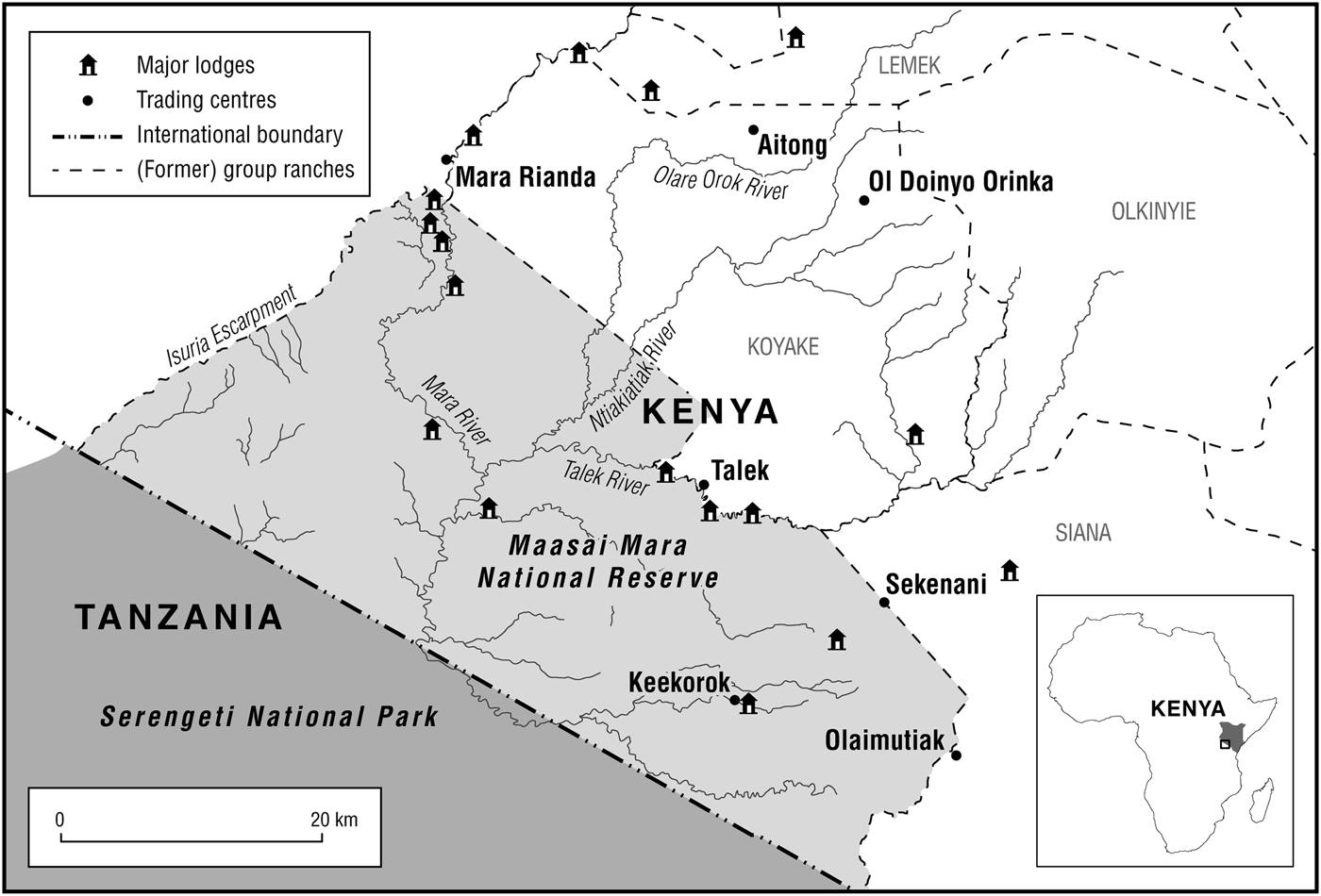
The political ecology approach I deploy in this paper is based on the use of geospatial technologies and on an appreciation that livestock and wildlife ‘agencies’ provide alternative explanations of livestock incursions into PAs, by embracing the spatial and temporal patterns of resource use, access and control – the central tenets of a political ecology of pastoralism (Little Reference Little, Bassett and Crummey2003). To substantiate the arguments in this paper, I depend on two main lines of evidence. First, I rely on key informant interviews with Maasai elders, herdsmen, ecological scientists, safari guides, rangers and other PA officials to better understand livestock movements into the MMNR and the drivers of these movements. My evidence is drawn from fieldwork around the Talek village centre, which lies immediately north of the border of the MMNR (Figure 1). Second, I draw on a large body of secondary literature on animal counts and popular media. These two lines of enquiry highlight competing evidence – in some cases contradictory – on the spatial and temporal patterns and processes of interaction among wildlife and livestock in drylands, as understood by both ecological scientists and Maasai pastoralists. All of the evidence is drawn directly from within the study site, unless otherwise noted. Understanding incursions as modern co-productions necessarily relies on multiple strands of literature from different disciplines and operating on different scales. My reliance on seemingly disparate literatures therefore reflects a concerted effort to understand not only the different factors and how they interact to produce incursions, but also the assumptions made (be they scalar, historical, ecological or political), in order to better understand incursions from these multiple perspectives.
The study area lies along the northern border of the Maasai Mara National Reserve in southern Kenya, approximately 250 kilometres south-west of Nairobi

In the next section, I briefly describe the socio-environmental history of the Maasai Mara in order to provide a historical context to the practice of incursions. I do this by demonstrating how land cover dynamics within the ecosystem are the product of complex and variable interactions between fire and herbivory that are both anthropogenic and natural.
THE SOCIO-ENVIRONMENTAL HISTORY OF THE MAASAI MARA
The MMNR (1,510 square kilometres) is a small part of the northern extension of the greater Serengeti-Mara ecosystem (SME) – an area of approximately 25,000 square kilometres (Sinclair et al. Reference Sinclair, Hopcraft, Olff, Mduma, Galvin, Sharam, Sinclair, Packer, Mduma and Fryxell2008). Whether through watching television documentaries or through magazines and books, we have all become familiar with the MMNR. Two unanswered questions associated with this evocative imagery are as follows: how did these landscapes come to be produced in the first place? And what are the implications of such production for contemporary PA management strategies?
Historian Jan Shetler has argued that the Western Serengeti has been created through thousands of years of human interaction with the environment (Shetler Reference Shetler2007) and that a ‘layering’ of social identity and human use by various ethnic groups has produced the savannahs we recognize today as the SME. This historical narrative has been complemented by archaeological research around the Rift Valley of southern Kenya, where at least 200 pre-historic pastoral settlements have been found, dating back as far as 2,000 years ago (Robertshaw and Brown Reference Robertshaw and Brown1990).
The broader Mara region has witnessed four dramatic land cover shifts over the last 160 years, which highlight how the landscapes we witness today are a product of human history:
1. Grassland to woodland (1850 to 1950): During this period there was a significant increase in the amount of bush land and wooded savannahs from the original grassland state. These changes in land cover are attributed to the spread of imported rinderpest, which reduced grazing densities by eliminating up to 80 per cent of livestock and wildlife and led to the expansion of tsetse fly habitats (Wilson Reference Wilson1987; Waller Reference Waller1990).
2. Woodland to grassland (1950 to 1960): This period was marked by a widespread rinderpest vaccination campaign (Sinclair et al. Reference Sinclair, Hopcraft, Olff, Mduma, Galvin, Sharam, Sinclair, Packer, Mduma and Fryxell2008) and an increase in the number of anthropogenic fires. The fires were set by Maasai herders, to improve pastures by eliminating ticks and to eliminate bush land that harboured tsetse fly that transmitted sleeping sickness, and by park authorities conducting fire management activities to alter the available biomass and attract migratory wild animals, which tourists travelled to see. There were also state-led tsetse control measures; these reduced the abundance of tsetse fly and led to a decline in woodland habitat (Waller Reference Waller1990).
3. Stable state grasslands (1960 to 1980): Wildebeest numbers rose from a little over 200,000 to 1.2 million (Serneels and Lambin Reference Serneels and Lambin2001a) as a result of the rinderpest release, which reduced the vulnerability of grazing ungulates to the disease. Conversely, elephant numbers declined significantly because of high rates of poaching in the Serengeti National Park. Elephants continued to use woodland areas for shade and to forage on woody species such as croton thickets (Dublin Reference Dublin, Sinclair and Arcese1995). The increase in the number of grazing ungulates as well as the increased use of woody areas resulted in a decline in the existing patches of woodland.
4. Grassland to agriculture (1980 to the present): There has been large-scale conversion of savannah grasslands to commercial-scale wheat production (Serneels and Lambin Reference Serneels and Lambin2001b) north of the SME. The drivers of this change are conducive state agricultural policies, increased private land tenure and market opportunities for mechanized agriculture (Homewood et al. Reference Homewood, Lambin, Coast, Kariuki, Kikula, Kivelia, Said, Serneels and Thompson2001).
There are two important points to draw from this short synthesis of the environmental history of the Mara ecosystem that inform how we view incursions as being co-produced. First, the physical environment within the Mara ecosystem has never been static: it is not the ‘pristine wilderness’ as commonly described by safari operators (Norton Reference Norton1996) or conservation organizations (IFAW 2010). Landscape changes have been a factor of anthropogenic as well as natural factors. Second, diseases and control measures have strongly influenced human and wildlife demographics over the past 160 years. These points are important because situating incursions within a historical context: (1) changes the starting point for conversations about illicit use and environmental change; and (2) helps clarify how land cover dynamics are important in understanding what is considered to be ‘wilderness’ or ‘pristine’.
POLITICAL GEOGRAPHIES OF RESOURCE CONTROL AROUND THE MARA REGION
The politics of producing productive lands
The MMNR was first produced in 1948 with the establishment of the Mara Game Reserve (MGR). The area carved out was an estimated 520 square kilometres and encompassed the land between the Isuria escarpment to the west, the Tanzania border to the south, and the Mara River to the north (Figure 1). This area was selected for the reserve because it featured a large density and distribution of charismatic mega-fauna (lions, elephants, buffalo and rhinos). Sport hunting safaris were common in the area prior to the establishment of the MGR and prohibited afterwards (Wilson Reference Wilson1987).
In 1961, control of the MGR was brought under the Narok County Council (NCC) – a local government administration system. Renamed the Maasai Mara National Reserve, the borders of the PA were extended east of the Mara River to encompass an area of 1,813 square kilometres. The primary reason for the devolvement of control from the central state to local government was effectively to share tourism revenues with the local community. Several hundred Maasai families were displaced from their grazing lands in order to create the reserve; many current residents still remember, with great sadness, the moment when they were ordered out of the expanded MMNR in 1961. Mzee KoshalFootnote 1 was a young Maasai man who was a locally recruited ranger at the time:
We were driven in six Land Rovers and a truck to the manyattas [homesteads] – all sixty of us. We asked the people to leave and burnt down their houses – even with their possessions still inside. We didn't think anything of it; we burnt the houses and left after telling the people that this was now a park.
By-laws of the MMNR state that there is to be no grazing by livestock or ‘human use other than development of appropriate facilities for tourists’ (Talbot and Olindo Reference Talbot, Olindo and Kiss1990: 69). This ordinance is extracted from the Wildlife (Management and Conservation) Act (Cap. 376) of 1976, which stated that ‘(3) Any person who, without authorization (f) knowingly introduces any animal or domestic animal or vegetation into a National Park; shall be guilty of an offence and liable to a fine not exceeding ten thousand shillings or to imprisonment for a term not exceeding one year or to both’, thus providing a legal basis for the restriction of cattle into PAs. It was also during this period (the 1970s and 1980s) that the economic value of wildlife tourism increased through better marketing and improvements in the safari infrastructure (camping locations and safari lodges). Tourist numbers peaked in the mid-1990s when the MMNR accounted for as many as 200,000 visitors annually (Karanja Reference Karanja, Walpole, Karanja, Sitati and Leader-Williams2003). Many local Maasai noted that there were only three camps along the Talek River between the Sekenani and Talek park gates during that same period. Today, there are over twenty camps in the same stretch.
Lying north of the MMNR is the former Koyake Group Ranch (KGR) (Figure 1). The KGR was one of a number of group ranches created by the Land Group Representatives (Ranches) Act of 1968. This legislation enabled rangelands, previously held as trust land for grazing by the leadership of a local district council, to be demarcated into several communally owned group ranches (Galaty Reference Galaty1992). Land in the group ranches was jointly owned and managed by an elected committee. Registered members held freehold titles to land and herded their livestock collectively, but they owned their herds individually. One of the aims of the state in setting up group ranches was to provide legal title to areas that the Maasai had historically used for centuries, which could then be used as collateral to finance infrastructure developments and to increase the economic value of pastoralists' livestock to the state (Galaty Reference Galaty1992). Additionally, the state sought to reduce stocking rates and land degradation in pastoral areas (Rutten Reference Rutten1992; Behnke and Muthami Reference Behnke and Muthami2011). However, the formation and operation of the group ranches were unequal across disparate social groups. Many of the elected committee members were also local elites who did not regularly disburse gains made from the group ranches (either through setting up campsites or from livestock products) across the different levels of the ranch membership (Thompson and Homewood Reference Thompson and Homewood2002; Sørlie Reference Sørlie2008).
In 1984, three excisions were made to the MMNR along the Mara and Talek rivers to provide Maasai and their livestock from the KGR access to perennial rivers essential for watering. This reduced the total area of the MMNR to 1,510 square kilometres (Walpole et al. Reference Walpole, Karanja, Sitati and Leader-Williams2003).
Thompson et al. (Reference Thompson, Serneels, Ole Kaelo, Trench, Homewood, Kristjanson and Trench2009) note that residents of the eight group ranches surrounding the MMNR should be entitled to 19 per cent of the annual revenues collected from park entrance fees. These revenues would be distributed through infrastructure projects in the form of schools, clinics and dispensaries as well as livestock dips. This payment system, which began in the late 1980s, was fraught with problems, as there was little oversight and transparency (Thompson et al. Reference Thompson, Serneels, Ole Kaelo, Trench, Homewood, Kristjanson and Trench2009: 101). To remedy the situation, a number of wildlife associations (community action groups) were formed in order to provide more equitable payments to community members. This attempt, too, failed to provide regular pay-outs to communities because of a lack of adequate participation in the political processes of revenue payments, corruption and the rise of local elites (Thompson and Homewood Reference Thompson and Homewood2002).
In 2002, members of the KGR voted to subdivide the ranch (Thompson et al. Reference Thompson, Serneels, Ole Kaelo, Trench, Homewood, Kristjanson and Trench2009). Many landowners in the KGR argued that they could receive benefits more directly from their individual titles to land if they were able to bypass corrupt group ranch officials and set up their own camps and lodges. ‘I never received any payments. When I asked about it to the chairman, he told me that the money was spent on bursaries [scholarships] for children to go to boarding schools in Lemek or Narok,’ said one former member of the KGR. Each registered group ranch member was eligible to receive an equal share of the communal holding (150 acres), although subdivision was rarely (and could not be) equitable in terms of quality, given the variability of the landscape. Elite members of the ranch allocated themselves parcels that were often close to rivers or shady areas that would attract the attention of private investors seeking to erect luxury tented camps and lodges (Sørlie Reference Sørlie2008).
Within the former KGR, the sudden ‘availability’ of land, which could be used to expand tourism and conservation ventures, led to intense interest on the part of private tourism operators, in conjunction with international and local conservation organizations, in the hope of gaining surplus revenue. Local elites were instrumental in facilitating the leasing of land to conservancies, and several conservancy members cited the names of a few individuals who ‘helped convince’ them of the need to sign the lease agreements.
By 2004, there were an estimated 1,200 individuals who had received legal title to their subdivided land contained within blocks 1 and 2 (clearly divided areas with defined criteria for development). At this time, livestock contributed approximately 70 per cent of the household income for the Maasai pastoralists within Talek and the remainder came from tourism (Thompson et al. Reference Thompson, Serneels, Ole Kaelo, Trench, Homewood, Kristjanson and Trench2009). It is important to note that there are significant variations within these proportions because some parcels of land have better game-viewing circuits and prime locations for luxury tented camps, which garner higher economic returns.
In early 2005, three private safari operators joined together to establish a ‘community conservancy’ that was carved out of the recently privatized KGR. By May 2006, this became the Olare Orok Conservancy (OOC) – 20,000 acres of land leased from 277 Maasai landowners (OOC 2012a) whose land directly borders the MMNR. Approximately 90 per cent of the landowners agreed to lease 150 acres of land each for a period of fifteen years for a monthly rental payment of 19,000 Kenyan shillings (Ksh) (approximately US$230). The remainder of the landowners leased the same amount of land for a period of five years, with a monthly lease payment of Ksh16,500 (US$200). Many Maasai landowners to whom I spoke stated that the process of leasing was complicated, with initial mistrust between landowners and conservancy managers. However, according to the OOC website, this process was as ‘easy as 1-2-3’ (OOC 2012a). First, ‘wildlife safari operators rent land from 277 Maasai landowners on a monthly basis. Second, Maasai pastoralists have reduced livestock herd sizes in core conservation areas. Third, the conservancy is now a haven for big cats, is part of the annual migration, and offers year-round prime wildlife viewing’ (OOC 2012a).
Given the failures of the group ranch associations and the NCC in adequately disbursing tourist revenues, Maasai landowners saw the conservancy as a way to increase their household income through steady payments made according to a more transparent process. Much of this plan was predicated on a reduction in herd sizes and the prohibition of livestock grazing on conservancy lands, because tourists on safari did not want to see cattle grazing inside the conservancy. In order to assuage community members' concerns regarding the reduction of their herd sizes, a number of concessions were made through hay-baling projects and infrastructure development (OOC 2012b). Pastoralists decided to choose the funds from the conservancies over the land on which they could graze their animals (Butt Reference Butt2011), and so they are ‘squeezed’ between the MMNR on the one side and the conservancies on the other.
Finally, the area around the northern border of the MMNR has experienced a rapid increase in human population and settlement density (Table 1). These changes are thought to be the product of high fertility rates, the relative improvement in healthcare facilities within the district (Sindiga Reference Sindiga1996) and changing land tenure policies – all of which have contributed to the increased sedentarization of Maasai livelihoods (Homewood et al. Reference Homewood, Kristjanson, Trench, Homewood, Kristjanson and Trench2009).
The number of households and individuals within the Koyake Group Ranch

Source: Lamprey and Reid Reference Lamprey and Reid2004: 1014.
Maasai pastoralists who reside around the PA have been ecologically marginalized, firstly by the loss of land to the MMNR and secondly by the loss of land to establish conservancies. Additionally, they have been economically marginalized by inequitable revenues from tourism and wildlife-viewing fees due to a lack of adequate political representation. Maasai landowners, despite the loss of grazing land to conservancies, are drawn to the promise of steady revenue payments offered by conservancy managers – essentially replacing the local government with private enterprise. Politics alone, however, does not cause incursions. While unequal power relations and multi-scalar political economies merge to disenfranchise pastoralists, movements into PAs are also affected by the changing material conditions of the landscape, which in turn influence patterns of resource utilization among grazing ungulates.
ANIMAL GEOGRAPHIES OF RESOURCE UTILIZATION
In this section of the paper, I examine the changes in the spatiality, temporality, demography and distribution of resource utilization among wildlife and livestock in and around the MMNR. These data are drawn from secondary literature on the relationships between wildlife and livestock and original work on livestock movements from the study site. The secondary data relating to trends in spatial and temporal patterns of wildlife and livestock relationships are on the landscape scale (hundreds to thousands of square kilometres); my own work on livestock herding patterns looks at smaller scales (tens to hundreds of square kilometres) and focuses on the level of the grazing orbit – the daily path traversed by pastoral cattle. Wildlife and livestock monitoring efforts on a large scale tend to result in coarser resolutions, capturing broad ecological processes, while much pastoral decision making is apt to rely on finer scales. I intentionally jump scales in order to capture the variety of different process-related scales. Scale, process and pattern are important in understanding incursions, given the changing materiality of the landscape and the fact that the agency of wildlife and livestock is patterned and structured in ways that show where, why and for how long different animals access and utilize resources. Through these analyses, we can begin to better understand the ways in which human-managed livestock and wildlife relate to one another in a highly variable environment.
Wildlife densities, distributions and interactions
The SME is considered to be one of the richest assemblages of wildlife in the world; millions of wildebeest, Thomson's gazelle and zebra migrate yearly within the area. The migration pattern begins from the wetter grasslands in the Serengeti between January and June, moving to the western corridor inside the MMNR in Kenya, where abundant forage from the wet season is consumed, before traversing the tall dry grasses back to the Serengeti between September and November. These movements are part of the Serengeti grazing succession, in which different species of grazing ungulates reduce the amount of forage to varying degrees. Larger grazing ungulates such as wildebeest and zebra are able to consume and digest coarse forage before smaller ungulates such as Thomson's gazelle eat the high-quality forage on pastures that others have abandoned (McNaughton Reference McNaughton1976). This is because large herbivores can ‘tolerate more fibrous and lower-quality diets than can small herbivores because of their larger gastrointestinal tracts and lower specific metabolic requirements’ (Bhola et al. Reference Bhola, Ogutu, Piepho, Said, Reid, Hobbs and Olff2012: 1511).
Wildlife populations around the MMNR have fluctuated over the last thirty years. Based on systematic reconnaissance flights (aerial surveys flown along selected flight lines in 5 kilometre square blocks) and geospatial analyses, estimated numbers of wet season migratory wildebeest increased from 220,000 in 1961 to over 1.3 million in 2001. This increase is attributed to the disappearance of the rinderpest virus in ungulate populations of the SME (Sinclair et al. Reference Sinclair, Hopcraft, Olff, Mduma, Galvin, Sharam, Sinclair, Packer, Mduma and Fryxell2008). Ogutu et al. (Reference Ogutu, Owen-Smith, Piepho and Said2011), using long-term monitoring data from census counts along road transects across the MMNR, have found that there was an almost uniform decrease in resident wildlife species inside the MMNR (except for Grant's gazelle, ostrich and elephants) and in the surrounding pastoral ranches (except for ostrich and elephants) between 1977 and 2010. During this period, both resident and migratory wildebeest were found to have declined by 97 per cent and 64 per cent respectively in the MMNR and by 82 per cent and 66 per cent respectively in the surrounding ranches. Declines were recorded for zebra during the same period.
Through the use of sophisticated spatial and statistical methods of analysis, such as spline and Poisson models, researchers have been able to spatially identify that the declines in resident wildebeest were greatest in the areas furthest away from the MMNR, while the greatest declines for migratory wildebeest were centred on the reserve. Increases in livestock grazing inside the park, poaching activities (Ogutu et al. Reference Ogutu, Owen-Smith, Piepho and Said2011) and the loss of habitat due to expanding wheat cultivation in areas north of the MMNR (Serneels and Lambin Reference Serneels and Lambin2001b) are cited as the main drivers for the declines in wildlife populations.
While wildlife declines are the cause of much of the contestation over incursions, many scientists argue that incursions are the product of increasing livestock densities, expanding distributions (Ogutu et al. Reference Ogutu, Owen-Smith, Piepho and Said2011: 102) and increasing frequency of movement in the MMNR. In the next section, I interrogate these claims with reference to scientific publications that reveal important nuances in resource utilization among pastoralists' livestock.
Spatial and temporal patterns of resource utilization by livestock
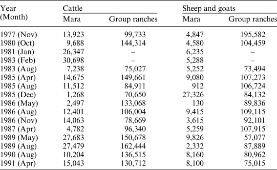
Data from aerial flights between 1980 and 2000 over much of the MMNR and the KGR reveal that during this period cattle numbers fluctuated between 6,000 and 55,000 (Lamprey and Reid Reference Lamprey and Reid2004). These fluctuations were the result of drought periods and large-scale livestock movements (Broten and Said Reference Broten, Said, Sinclair and Arcese1995; Ottichilo et al. Reference Ottichilo, Said, De Leeuw, Skidmore and Prins2000; Lamprey and Reid Reference Lamprey and Reid2004). Lamprey and Reid (Reference Lamprey and Reid2004) estimate that 75 per cent of the variation in wet-season cattle numbers can be explained by rainfall in the previous two years, although none of the variation can be explained in the dry season, as there are on- and off-ranch movements mainly to neighbouring Trans Mara District, where orographic precipitation is more reliable. A separate ground count in 2002 across the same region, involving vehicles sampling at 1 square kilometre blocks, suggests that there were 31,683 cattle within the MMNR and the KGR (12,910 of which were found inside the MMNR) (Reid et al. Reference Reid, Rainy, Ogutu, Kruska, McCartney, Nyabenge, Kimani, Kshatriya, Worden, Ng'ang'a, Owuor, Kinoti, Njuguna, Wilson and Lamprey2003). Some of the earliest estimates of wildlife and livestock in and around the MMNR always noted the presence of cattle inside the reserve (Table 2).
Historic livestock population numbers inside and outside the MMNR, 1977–91
Source: Broten and Said Reference Broten, Said, Sinclair and Arcese1995.
Analysis of livestock numbers reveals a different picture: the number of cattle within the reserve increased by 1,104 per cent, rising from 2,001 cattle in the period 1977–79 to 24,112 cattle in 2007–09 (Ogutu et al. Reference Ogutu, Owen-Smith, Piepho and Said2011: 105). The number of cattle within the surrounding ranches increased in the thirty-year period (from 4,590 in 1977–79 to 7,951 in 2007–09). Seasonal analysis for the same area found that there was significant spatial variation whereby ‘cattle were more abundant in the ranches than in the reserve in the dry season but more occurred in the reserve in the dry than in the wet season and more recently (2000–2010) than in earlier years (1970–1999)’ (Bhola et al. Reference Bhola, Ogutu, Piepho, Said, Reid, Hobbs and Olff2012: 1517).
The underlying ecological processes driving these spatially different densities are the amount of forage taken by cattle and the implications of the reduced height of forage for wildlife. The size of animals influences the spatial distribution where ‘medium sized (wild) herbivores tend to utilize the ranches when water and short, nutritious grasses, created and maintained by heavy livestock grazing (Rannestad et al. Reference Rannestad, Danielsen, Moe and Stokke2006) [enable] them to enhance their total protein consumption (McNaughton Reference McNaughton1976)’ (Bhola et al. Reference Bhola, Ogutu, Piepho, Said, Reid, Hobbs and Olff2012: 1523). The changing materiality of the grasses also affects the relationship between livestock and wildlife: short grasses enhance the visibility of predators, thus potentially lowering predation risk in the ranches compared with the reserve (Hopcraft et al. Reference Hopcraft, Sinclair and Packer2005; Ogutu et al. Reference Ogutu, Bhola and Reid2005). Thus the spatially differentiated grazing density of livestock similarly alters the resource utilization patterns of wildlife.
Additional research from within the study region highlights how pastoralists and their livestock can create beneficial environments for wildlife through a number of different pathways (Bhola et al. Reference Bhola, Ogutu, Piepho, Said, Reid, Hobbs and Olff2012; Butt and Turner Reference Butt and Turner2012). Data from the Amboseli ecosystem in southern Kenya clearly demonstrate that abandoned pastoral homesteads become nutrient hotspots that attract wildlife because of the nutritious grasses sprouting there – a product of dung accumulation (Muchiru et al. Reference Muchiru, Western and Reid2009). Experimental work from the Mpala Research Centre in central Kenya has suggested that cattle grazing can facilitate wildlife by modifying grazing environments, depending on seasonality (Odadi et al. Reference Odadi, Karachi, Abdulrazak and Young2011). In general, there is consensus that both old settlements and the grazing actions of cattle in the dryland ecosystems of Kenya can have positive influences on biodiversity structure and function, although these influences are highly dependent on the level and type of activity. However, where livestock mobility is limited, there is heavy grazing and trampling, which has a negative impact on the onset and duration of green biomass (Butt Reference Butt2010a). These legacies of pastoral settlement effects demonstrate how pastoralists modify the environment, facilitating certain wildlife species. Thus popular notions of incursions are also devoid of ecological understandings, which demonstrate how pastoralists produce the landscapes on which wildlife thrives, under specific conditions.
Beyond larger-scale analyses of livestock densities and distributions within the two broad political spaces (ranch versus reserve), research on pastoral cattle mobility at the village level, derived from GPS units (Figure 2), has found that: (1) cattle movement into PAs is widespread; (2) neither herd size nor season are significant limiting factors influencing movements into the MMNR (Butt et al. Reference Butt, Shortridge and WinklerPrins2009); and (3) the highest frequencies are recorded during drought periods (for example, during the drought of 2005–06, up to 99 per cent of daily herding was being conducted inside the MMNR (Butt Reference Butt2011)). Further analyses of pastoral livestock interactions with the physical environment, combining GPS-derived cattle mobility patterns and satellite-derived measures of vegetation productivity, find the following:
1. The spatial distribution of cattle density on the landscape as a function of distance away from the household shows seasonal differences.
2. The highest cattle densities are found in spatially distinct areas of the landscape in different seasons. In other words, pastoralists do not graze the same areas repeatedly across different seasons.
3. The increased cattle density in areas around the household during the wet season has differential impacts on the environment as the phenology of grasses in these areas demonstrates markedly different rates and magnitudes of green-up and brown-down (Butt Reference Butt2010a).
There are several key points to take away from these findings of animal geographies within and around the MMNR and the KGR. First, the rapid increase in migratory wildebeest numbers has only occurred over the last fifty years. Spatially, the migration takes place both within and outside the MMNR and, temporally, the abundance of wildebeest is greatest during the dry season. Decreases in wildlife numbers have been largely attributed to livestock grazing, poaching, and loss of habitat from expanded wheat cultivation. Second, cattle grazing can have both positive and negative effects on wildlife habitat. Third, livestock have consistently utilized the reserve since before the late 1970s and the densities of livestock within the reserve are increasing, as is the periodicity of their movements. Finally, patterns of resource utilization among pastoral livestock and their effects on the environment are both spatially and temporally variable.
Illustrative GPS-derived path of cattle mobility (at ten-second intervals) for one household bordering the MMNR over the course of a single day (5 August 2009), season (dry season 2009) and year (wet and dry seasons 2009). The grey shaded areas on the maps to the left are the approximate borders of the PA. The maps to the right show an inset area where the actual paths of mobility can be seen. There is heavy cattle utilization on specific paths that lead to and from the Maasai pastoral household.
‘INCURSIONS’: THE INTERSECTION BETWEEN ANIMAL AND POLITICAL GEOGRAPHIES
Given information on the political geographies of resource control, and animal geographies of resource utilization, what factors influence pastoralists' decisions to enter the MMNR, and how are relationships between pastoralists and PA managers based on differing ways of contextualizing movements into the PAs? To answer these questions, I downscale the level of the analysis to focus on household-level decision-making processes among pastoralists and PA managers.
Herding decisions of pastoralists around protected areas
Pastoral herding decisions are governed by both household- (social) and landscape-level (ecological) considerations that synergize on any given day to produce a particular grazing path (Butt Reference Butt2011; Burnsilver et al. Reference Burnsilver, Boone, Galvin, Fox, Mishra, Rindfuss and Walsh2003). Household-level factors include the quantity and quality of herding labour, the size and composition of the herd, and the relationship of the herder to the herd owners, among several other factors. Landscape-level factors include the quality and quantity of water and forage resources, and the density and distribution of other cattle herds, as well as the susceptibility of the herd to epizootic diseases such as sleeping sickness (spread through the tsetse fly) and malignant catarrhal fever (spread through the afterbirth of wildebeest). Herders will often consult elders and other herders about the best grazing strategy anywhere from an hour before herding to two days or even a week before. Herders also make spontaneous decisions on where to graze after herding has begun and often due to rapid changes in social and ecological constraints, such as the likelihood of attack by wildlife on cattle and the influence of ranger patrols when herding is conducted inside the PA (Butt Reference Butt2011).
For most pastoralists, landscape-level decisions associated with grazing inside the MMNR are spatially and temporally patterned based on the need to ecologically balance forage intake with energetic costs (Butt Reference Butt2010b). During the wet season, forage and water are locally abundant and herders do not have to manage livestock deep inside the PA. However, for settlements located metres away from the border of the MMNR, this still results in movement into the PA (Butt et al. Reference Butt, Shortridge and WinklerPrins2009). As the dry season progresses, forage desiccates and quality forage is located in key resource areas distributed throughout the interior of the park. A key factor in the variability of forage in and around the study area is that the wildebeest grazing during the migration significantly reduce the amount of forage available for pastoralists' cattle, between June and September, when over a million wildebeest graze in areas both inside and outside the MMNR.
Historically, pastoralists would access grazing lands before and during the existence of the MMNR and the KGR. Both areas afforded spatially and temporally variable forage and water to pastoralists. Herding movements into the MMNR were most common during extended dry periods and drought, while the KGR was a regular grazing area when it was not abnormally wet or dry. The decision to graze inside the MMNR is significantly influenced by herd size in the wet and dry seasons, but not during drought (Butt Reference Butt2011). Additionally, the distance travelled into the MMNR is greater for larger herds than it is for smaller herds (Butt et al. Reference Butt, Shortridge and WinklerPrins2009; Butt Reference Butt2011). The herding decisions associated with pastoralists who reside around the periphery of the MMNR differ not only in terms of seasonality, but also as a function of social groupings. More specifically, the timing of grazing decisions and the herd management strategies are likely to be more beneficial for large herds (indicative of greater wealth) than for smaller herds (Butt Reference Butt2011).
A significant factor associated with the decision to graze livestock in the MMNR is the creation of the OOC, which reduced the amount of available grazing lands for the Maasai in areas outside the MMNR. The decision to lease land to the conservancy was primarily influenced by the promise of a more reliable source of income. Mzee Saiyalel was allocated 150 acres after the subdivision of the KGR, but he was reluctant to lease his land to the conservancy for fifteen years. ‘Fifteen years is a long time,’ he said to me. ‘In that time, I can get maybe three times as many cows. Maybe I can put up my own camp also.’ However, as I discuss in the next subsection, these decisions are not based solely on monetary and resource concerns, but also on the increased securitization of the conservancy and the MMNR.
Relationships between pastoralists and protected area managers
Over the past decade, many interviews with herders and elders have noted that the relationships between pastoralists and PA managers are deeply antagonistic. However, there is evidence to suggest that this was not always the case. During the 1970s and 1980s, a period of much lower cattle density, cattle grazing was still prohibited inside the PA but pastoralists would approach PA officials and seek permission to graze their livestock inside the MMNR. For example, a Maasai elder, in describing the drought of 1984, stated that:
We visited the [senior] warden and took him a gift of a he-goat and maize beer … we politely asked him to allow us to graze in the park because of the drought … He never hesitated. He told us where to graze – in the designated areas of the park [between Posse and Oon'gila]. As soon as the rain fell we removed our livestock out of the park without being ordered to do so by the park authorities.
The historical relationships between pastoralists and the MMNR revolved around a moral economy where park authorities were cognizant of the ecological and social needs of pastoralists. Not only did PA managers allow cattle into the MMNR during drought periods, they also assisted local communities when neighbouring ethnic groups raided their cattle. Many rangers and senior park wardens were considered members of the community and took part in cultural ceremonies as well as transporting sick people to the district hospital. Mzee Ole Nkiok told me a story of the former senior park wardens (Major General Temple Boreham and Ole Tipis):
By the time this park was introduced, by a mzungu [white man] called Temple, we have just settled permanently here … when cattle raiding incidences occurred, he instructed the rangers to assist the herders to get back their livestock [that] were taken by armed ‘ilmutendes’ [livestock raiders]. I have seen this happen when Soit's herd were raided and brought back safely by the game rangers.
Beginning in the late 1990s (the same period during which tourist numbers peaked), this relationship began to sour when park authorities began restricting cattle movements into the MMNR, more harshly than they had in the past, even during periods of drought. Pastoralists found herding their cattle inside the MMNR were caught and fined up to Ksh10,000 (US$165) per herd. In some cases, the Maasai would combine herds to avoid paying the full Ksh10,000. The financial repercussions were compounded by the physical and emotional costs borne by pastoralists. Rangers resorted to violent tactics to capture and detain herders. Herders were often beaten and abused at the hands of the rangers and their cattle were confiscated and placed in secure enclosures at the park gates. Ole Murunya, another Maasai elder, recalled:
Today, even if a three-year-long drought comes [the] senior warden cannot allow us to graze inside the park. Also during Ole Tipis' reign, [he would] give out the county council car to take the sick to the hospital. Today, even if someone is dying on the side of the road I am sure they will not even stop and help them. Today, the game rangers and the herders are like a hyena and a donkey – total enemies.
Yet these stories do not tell us why the relationships between pastoralists and PA managers have deteriorated. From interviews and observations with both groups, I have noted that these conflicts are the products of three simultaneous transformational moments concerning the ways in which tourists themselves understand and experience the MMNR. The first concerns the creation of the safari as a distinct commodity, which is predicated upon a separation between ‘nature’ and ‘culture’, and where ‘nature’ is equated to wildlife-rich savannah landscapes devoid of humans. This binary has led to situations where tourists are dissatisfied (and indeed angry) when they witness cattle grazing inside the MMNR (Kemei Reference Kemei2006). It is also important to note that the binary between nature and culture is being driven not just by the increase in volume of tourists to the Mara, but by the expectation of the safari itself (Norton Reference Norton1996): tourists are promised in advertisements that they will see the ‘Big Five’ (leopards, lions, buffalo, rhino and elephants), and tour drivers are promised better tips if they encounter these animals (Butt Reference Butt2012).
The second moment of transformation concerns the strategic spatial and temporal placement of MMNR officials to protect the safari experience. The protection of the ‘authentic’ safari experience limits tourists' interactions with local productive peoples, deepens the nature–culture binary, obscures tourists' understanding of the way in which the safari has been created, and forcefully evicts and fines herders caught grazing inside the MMNR. For example, tourists' only interactions with local Maasai happen when they are taken to cultural manyattas between mid-morning and mid-afternoon (in between game drives) – a time when most cattle are away from the household. Each encounter lasts no more than 30 minutes, and tourists are shown curios, staged dances and a tour of the households.
The third moment relates to how the creation and protection of the safari experience and the fetishisms surrounding it lead to processes of identity creation. Tourists and rangers regard herders as transgressors of pristine wilderness; tourists identify rangers as protectors of nature and herders view rangers as contemporary cattle raiders. Rangers see cattle grazing inside the park as a threat to their identities as protectors of nature (Butt Reference Butt2012). On no occasion did I find that PA managers acknowledged that the grazing activities of pastoral cattle actually help to create the environment that wildlife find favourable.
The specific forms, tactics and repertoires of the conflicts between herders and MMNR officials, much like the ecology of resource utilization among wild and domestic herbivores, is also spatially and temporally patterned. Tourism in the MMNR is highest during the migration (between June and September), which is also the local dry season. Forage constraints are high for pastoralists and there is significant overlap between cattle and wildebeest. This is the period during which conflicts are greatest between cattle and wildlife. During the wet season (April to May), when forage is not limited, cattle do not need to enter the MMNR as frequently, or travel as deeply inside it. This is also the period when tourist numbers are at their lowest and occupancy rates in the hotels and lodges can be as low as 20 per cent.
These drivers of resource conflicts are not specific to the MMNR. In the past seven years, conservancy managers have adopted similar approaches, although with less violent tactics than those of their counterparts in the MMNR. However, the ‘lesser’ violence comes at the cost of conservancy fines for grazing – also Ksh10,000 – but also entails the loss of grazing privileges for the whole community of landowners covenanting land. This has meant that there is stronger peer pressure against non-compliance for herders who have leased their land to the conservancy. The legal commitment to five- or fifteen-year leases of grazing land to conservancies, in return for payments that do not provide a substitute for the livestock production lost, is now no longer capable of being recouped by incursion into the MMNR.
CONCLUSIONS: TOWARDS A POLITICAL ECOLOGY OF INCURSIONS
The movement of domestic animals into PAs is a worldwide phenomenon. Yet much of the understanding of incursions tends to be poorly contextualized and inadequately examined. In this paper, I have presented a case study from the Maasai Mara to question how such movements come to be produced rather than taken as a given, to understand relationships between pastoralists and PA managers, and to examine how each group understands livestock movements into PAs.
By placing livestock movements and the establishment and operation of the PA into a historical context, we find that the PA is a product of human history and modification of the physical environment. There has also been significant human demographic change within the Mara region, while changes in livestock demography are less clear: some researchers suggest that livestock numbers in the reserve have increased (Ogutu et al. Reference Ogutu, Owen-Smith, Piepho and Said2011) while others suggest that numbers have fluctuated within the periods of analysis (Broten and Said Reference Broten, Said, Sinclair and Arcese1995; Lamprey and Reid Reference Lamprey and Reid2004). Changes in human demography do not easily translate into concomitant changes in livestock demography because the latter are mediated by climatic variability and herd management strategies, both of which are spatially and temporally heterogeneous. Ecologically, the grazing actions of livestock help to facilitate beneficial environments for wildlife, and the spatial patterns of wildlife and livestock are seasonally variable. Despite this, however, the frequency of livestock movements into the MMNR has increased substantially, while the spatial extent of grazing areas available for pastoralists has decreased because of changes in land tenure and the politics of land management.
I have argued that incursions are modern co-productions that arise from the changing intersections between the politics of PA management strategies and ecologically varied geographies of resource utilization. Most importantly, this investigation has revealed that PA managers did not see livestock movements into the MMNR as incursions until the advent of greater resource controls, which are driven by changes in the governance of natural resources and the commoditization of the safari. The increased securitization of the PAs did not take place until monetary flows increased to the institutions that manage these PAs. This came about through the growing influence of tourism and safari ideals that are predicated on an intentional separation between ‘nature’ and ‘culture’. Incursions, therefore, are not a given – instead, they are produced in relation to how key actors characterize the relationships between wildlife and livestock, which are fluid across both space and time.
While traditional political ecological approaches tend to methodologically highlight the use of participatory social-scientific approaches, this research highlights the importance of melding such approaches with data derived from technologies such as GPS, satellite imagery and aerial census counts to reveal the spatial and temporal heterogeneity inherent within the physical landscape as well as the socially varied dynamics of resource access. These technologies can be powerful tools to question the ways in which people's interactions with PAs have been portrayed.
ACKNOWLEDGEMENTS
The author would like to acknowledge Kayla Yurco, Jenny Cooper and Meghan Cornwall, as well as the reviewers, for their insights into this paper.