


Introduction
As anthropogenic pressures build on wildlife across the modern world, it is of particular importance to identify the habitat requirements of little-known species as a crucial first step towards appropriate conservation management (Possingham et al. Reference Possingham, Andelman, Noon, Trombulak, Pulliam, Soulé and Orians2001; Manly et al. Reference Manly, McDonald, Thomas, McDonald and Erickson2002; Jones Reference Jones, Marzluff, Bowman and Donnelly2004; Brooks et al. Reference Brooks, Mittermeier, da Fonseca, Gerlach, Hoffmann, Lamoreux, Mittermeier, Pilgrim and Rodrigues2006; Delong and Steenhof Reference Delong and Steenhof2020). The monotypic Green Avadavat Amandava formosa, also known as Green Munia, is endemic to central India, occurring very locally within a fragmented range extending from southern Rajasthan to Odisha and Andhra Pradesh (Collar et al. Reference Collar, Andreev, Chan, Crosby, Subramanya and Tobias2001; Payne Reference Payne, del Hoyo, Elliott, Sargatal, Christie and de Juana2021). The unexplained patchiness of the species may involve undetected habitat requirements, but could also reflect pressure from the cage-bird trade in India (Bhargava Reference Bhargava1996; Collar et al. Reference Collar, Andreev, Chan, Crosby, Subramanya and Tobias2001) and beyond (Teschemaker Reference Teschemaker1905, Rahmani et al. Reference Rahmani, Kalra and Khan2012). In view of this (now illegal) trade combined with presumed habitat loss to intensifying agriculture, the species is variously classed as ‘sensitive’ (eBird Sensitive Species Committee 2017), of ‘high’ conservation priority (SoIB 2023; Praveen Reference Praveen2025) and globally Vulnerable (Collar et al. Reference Collar, Andreev, Chan, Crosby, Subramanya and Tobias2001; IUCN 2018), having a declining population estimated at just 6,000–15,000 mature individuals (BirdLife International 2018, SoIB 2023). It is listed in Appendix II of CITES (CITES Appendices 2023) and on Schedule-I of India’s Wildlife Protection Act (Wildlife Protection Act 2022).
Within its known range, Mount Abu Wildlife Sanctuary (hereafter MAWLS), at Mount Abu in southern Rajasthan, is the species’ stronghold (Butler Reference Butler1875; Collar et al. Reference Collar, Andreev, Chan, Crosby, Subramanya and Tobias2001; Sangha and Devarshi Reference Sangha and Devarshi2006; Rahmani et al. Reference Rahmani, Kalra and Khan2012) and possibly the only site in the world where it can be found with relative ease. There, it is usually seen in grassy patches within a mosaic of boulders, streams, fields and shrubs comprising the native Karonda Carissa spinarum along with the invasive Lantana Lantana camara and Mysore Thorn Biancaea decapetala, which are used for cover and breeding (SZ pers. obs.). However, a deeper understanding of its distribution and habitat preferences is needed to ensure appropriate future management at MAWLS, which is now facing various human pressures on land belonging to the Forest Department at the sanctuary’s periphery and close to the main town and surrounding villages (Patil et al. Reference Patil, Dharaiya and Thatte2022; Zutshi Reference Zutshi2024). Already captive breeding is being attempted as a means of bolstering its populations (BNHS 2023), so a better knowledge of its preferred habitat will obviously help inform choices of release sites for any introductions and management across its range.
Methods
Study area and habitats
MAWLS is situated in the south-western Aravalli ranges in Sirohi District, Rajasthan, spanning approximately 326 km2, between 24°33′ and 24°43′N and 72°38′ and 72°53′E. It was declared a wildlife sanctuary in 1960 (MoEFCC 2020) and is an Important Bird Area (IN067) and Key Biodiversity Area (Site 18354) (BirdLife International 2004; KBA Partnership 2025) (Fig.1). Along with Mount Abu town, a hill-station and major tourist destination, it falls within a declared Eco-Sensitive Zone (ESZ) (MoEFCC 2020). Eighteen villages surround the higher municipal area of the town and MAWLS, and over forty villages are located around the lower periphery. There are ten forest blocks within MAWLS, eight of them reserved forests comprising 104 km2 and two being protected forests covering 222 km2 (Rajasthan Forest Department 2012).
Distribution and abundance of Green Avadavats by grid squares at Mount Abu Wildlife Sanctuary, March–August 2023.
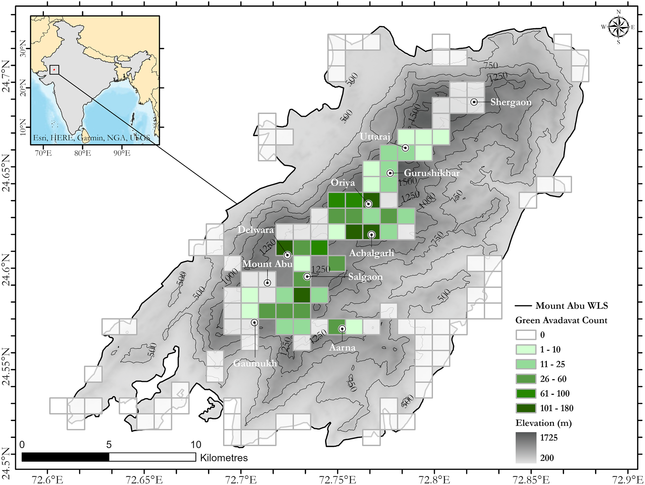
Figure 1. Long description
A topographical map with an inset map of India in the top-left corner showing the sanctuary’s location in Rajasthan. The main map uses grayscale shading to represent elevation from 200 to 1725 meters, with contour lines labeled at 500, 750, 1000, 1250, and 1500 meters.
Superimposed on the topography is a grid of squares indicating Green Avadavat counts. The highest concentrations (101 to 180 individuals, shown in dark green) are clustered in the central high-elevation regions near Oriya and Achalgarh. Moderate counts (26 to 100, medium green) surround these cores, extending toward Mount Abu and Salgaon. Lower counts (1 to 25, light green) are found at the edges of the central plateau near Gurushikhar, Uttaraj, and Aarna. Empty white grid squares indicate zero counts, primarily located in the lower-elevation peripheral areas of the sanctuary.
Key locations marked with circular icons include Shergaon in the Northeast, Gurushikhar and Oriya in the center, and Gaumukh in the Southwest. A scale bar at the bottom-left indicates 0 to 10 kilometers, and a compass rose is in the top-right corner. The legend at the bottom-right defines the Green Avadavat Count color scale and the Elevation grayscale.
The forests in the sanctuary are classed as Southern/Central Indian subtropical broadleaved hill forest (Champion and Seth Reference Champion and Seth1968) and the remaining vegetation consists of xeromorphic subtropical scrub and thorn forests in the foothills, and scrub and subtropical semi-evergreen forest along streams, deep gorges and valleys at higher altitudes (Rajasthan Forest Department 2012). The hilly landscape is boulder-strewn with several reservoirs and seasonal streams that are recharged during the monsoon season (usually occurring mid-July to mid-September). In an eco-region otherwise dominated by arid conditions (Sharma et al. Reference Sharma, Kulshreshtha and Rahmani2013), MAWLS harbours a rich avian and floral diversity, owing to the range of habitats, altitudinal variation (extending 300–1,722 m a.s.l) and a distinct, humid subtropical and tropical savanna climate in the foothills (Köppen–Geiger Classification 2025). Mean annual precipitation is 1,389 mm (IMD 2022), with a short, wet monsoon season in late-July–August, often extending into September; however, an increasing number of unseasonal, intense rainfall events have occurred in recent years. The mean daily maximum temperature at Mount Abu is 25.9°C, with a recorded high of 40.4°C and a low of −7.4°C (IMD 2022). During the dry winters, sub-zero night-time temperatures are routinely recorded in December and January.
Field protocol and data collection
Surveys to record avadavat presence and numbers, and to measure habitat variables, were conducted at MAWLS between mid-March and early August during the mostly dry (sporadically wet) spring and summer season of 2023. The study area was split into 451 1×1 km grid squares spanning the entire wildlife sanctuary area, 40% of which were surveyed, including the foothills and periphery of the sanctuary. To determine suitable survey areas, squares were rated according to the likelihood of detecting Green Avadavats based on (a) locations of previous observations (including ten squares within Mount Abu town), (b) general habitat based on previous observations (scrub-dotted grassy patches in a mosaic of boulders, woodland and streams near fields and villages at higher elevations) and (c) citizen science records (eBird 2023; iNaturalist 2025). Once these known and likely suitable squares had been surveyed, a random selection of remaining squares was targeted (Figure 1). However, certain areas of MAWLS—particularly the south-west and south-east, and the elevation range 500–1,000 m a.s.l—could not be surveyed owing to poor or no access roads and trails (numerous dead ends), difficult terrain (steep slopes and many cliffs) and impenetrable vegetation.
Survey squares were divided into four quadrants, and two experienced observers (one SZ), walking in a north-facing clockwise direction within a square, spent a minimum of 30 minutes in each quadrant. The walking route within a square was plotted considering ground practicalities such as access and obstacles, but as far as possible passing through or close to the various habitats contained within it. Sampling was conducted between 06:00 and 12:00 in 75 squares (58.2%) and between 15:00 and 18:00 in 54 squares (41.8%). Within each square, the following habitat characteristics were recorded: mean altitude, percentage grass cover, percentage rapidly spreading shrub vegetation (invasive Lantana camara, invasive Biancaea decapetala and native Carissa spinarum) and total survey time in minutes (effort). Grass and shrub cover variables were assigned using open-source satellite imagery before surveying the whole square and verified by estimation during on-site sampling.
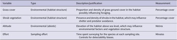
A strip width of approximately 200 m was possible in most squares, and vantage points were sought to maximise coverage and detection. As much as possible equal effort was made to survey each square, while accepting topographical limitations. Table 1 details the habitat predictor variables collected.
Habitat predictor variables recorded during the surveys
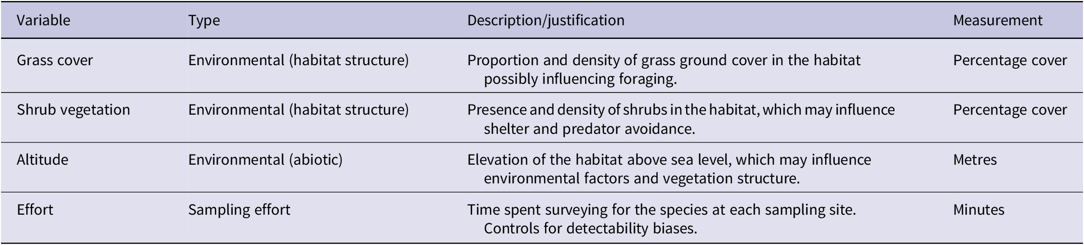
Table 1. Long description
The table consists of four columns titled Variable, Type, Description/justification, and Measurement.
* Row 1: Variable is Grass cover. Type is Environmental (habitat structure). Description is the proportion and density of grass ground cover in the habitat possibly influencing foraging. Measurement is Percentage cover.
* Row 2: Variable is Shrub vegetation. Type is Environmental (habitat structure). Description is the presence and density of shrubs in the habitat, which may influence shelter and predator avoidance. Measurement is Percentage cover.
* Row 3: Variable is Altitude. Type is Environmental (abiotic). Description is the elevation of the habitat above sea level, which may influence environmental factors and vegetation structure. Measurement is Metres.
* Row 4: Variable is Effort. Type is Sampling effort. Description is the time spent surveying for the species at each sampling site to control for detectability biases. Measurement is Minutes.
Statistical analyses
Since understanding the conditions that favour the birds’ presence was a key aim, a binomial generalised linear model using a logit link function was fitted, with species presence/absence as the response variable, and grass cover (%), combined shrub vegetation cover (%), mean altitude of the square (metres), and the sampling effort in each square derived from GPS track data (minutes) as predictors. We evaluated all possible subset combinations of the habitat and effort variables, and selected the best model using the AIC criterion corrected for a small sample size (AICc), from which we estimated parameters (Burnham and Anderson Reference Burnham and Anderson2002). Standardised regression coefficients were calculated to facilitate comparison of the relative effect sizes of predictor variables (Table 2), whereas unstandardised parameter estimates, standard errors, z-statistics and P-values are reported for the best-supported model (Table 3). Relative variable importance (RVI) was calculated by summing Akaike weights across all candidate models, and variance inflation factors (VIF) were calculated for predictors in the best-supported model to assess multicollinearity. All analyses were performed in program R (R Core Team 2020) using the MuMIn package (Barton Reference Barton2020).
Model selection results for the presence of Green Avadavats at MAWLS based on habitat characteristics and survey effort. Shown are standardised coefficients for variables entered into the ‘top five’ competing models, AICc and ΔAICc values, and model weights. Models are ordered by increasing ΔAICc

Table 2. Long description
The table contains eight columns: Model (variables selected), Effort (mins), Grass cover (%), Shrub vegetation cover (%), Mean altitude (m), A I C c, Delta A I C c, and Weight.
* Row 1: Effort, grass cover, shrub cover, altitude. Coefficients: Effort 1.04, Grass 0.96, Shrub 2.38, Altitude 1.62. A I C c 71.2, Delta A I C c 0, Weight 0.713.
* Row 2: Effort, shrub cover, altitude. Coefficients: Effort 1.07, Grass (none), Shrub 2.44, Altitude 2.4. A I C c 74.8, Delta A I C c 3.59, Weight 0.119.
* Row 3: Effort, grass cover, shrub cover (no altitude). Coefficients: Effort 1.12, Grass 1.21, Shrub 2.94, Altitude (none). A I C c 75.4, Delta A I C c 4.18, Weight 0.088.
* Row 4: Grass cover, shrub cover, altitude (no effort). Coefficients: Effort (none), Grass 1.03, Shrub 2.04, Altitude 1.61. A I C c 75.9, Delta A I C c 4.71, Weight 0.068.
* Row 5: Shrub cover and altitude only. Coefficients: Effort (none), Grass (none), Shrub 2.02, Altitude 2.2. A I C c 81.5, Delta A I C c 10.3, Weight 0.004.
Unstandardised parameter estimates for the best-supported binomial GLM, together with variance inflation factors (VIF) and relative variable importance (RVI). Estimates, standard errors, z-statistics and P-values are from the best-supported binomial GLM. VIFs were calculated for predictors in the best-supported model. RVI was calculated as the summed Akaike weights across all candidate models

Table 3. Long description
The table contains seven columns: Variable, Estimate, Std. Error, z, P, V I F, and R V I. There are four rows of data:
* Survey effort (min): Estimate 0.0268, Std. Error 0.0114, z 2.35, P 0.019, V I F 1.28, R V I 0.925.
* Grass cover (percent): Estimate 0.0444, Std. Error 0.0195, z 2.28, P 0.023, V I F 1.13, R V I 0.875.
* Shrub vegetation cover (percent): Estimate 0.0875, Std. Error 0.0307, z 2.85, P 0.004, V I F 4.18, R V I 0.995.
* Mean altitude (m): Estimate 0.0035, Std. Error 0.0018, z 1.99, P 0.046, V I F 4.17, R V I 0.908.
Results
Distribution at MAWLS
Of 129 squares surveyed, the species was recorded in 40 (31%), with a total of 1,520 Green Avadavats detected during the survey. Most detections were visual (94%; mostly heard first, then seen), with the remainder (6%) by call only. Avadavats were widespread towards the north and centre of the study area, with the largest numbers being found around Oriya (180 individuals in a square), Achalgarh (147 individuals), Delwara and Bhimalaya areas (108 individuals each). Good numbers (over 50) were also recorded in squares in the Aarna, Salgaon, Torna, Hetamji and Gaumukh areas (Figure 1). Birds were recorded in squares with mean altitude between 775 m and 1,592 m, on the ascent to Guru Shikhar (1,722 m), the highest peak in the Aravalli range. The highest altitude at which the birds were recorded was 1,703 m. The mean altitudinal range of surveyed squares was 1,330 m (260–1,591 m); 62 squares (48% of surveyed squares) were below 775 m with no bird detections.
Model results
The best-supported model (with the lowest AICc) contained all the predictors (Table 2), whereas the second most likely model did not include grass cover proportion. The best model had a weight of 0.71, compared to the second model’s 0.12, with a ΔAICc of 3.59.
Relative variable importance (RVI) scores indicated that shrub vegetation cover had the strongest support (RVI = 0.995), followed by survey effort (0.925), mean altitude (0.908) and grass cover (0.875; Table 3). The best-supported model indicated that Green Avadavats were significantly more likely to occur in squares with higher shrub vegetation cover (estimate = 0.08749, P = 0.00437), greater survey effort (estimate = 0.02681, P = 0.01867), higher grass cover (estimate = 0.04435, P = 0.02289) and at higher mean altitudes (estimate = 0.00349, P = 0.04612; Table 2). There was a strong positive correlation between shrub vegetation cover and altitude (r = 0.87, P < 0.0001), but no significant correlation between grass cover and altitude (r = −0.14, P = 0.12). Despite the strong correlation between shrub vegetation cover and altitude, variance inflation factors for all predictor variables were below 5 (Table 3), indicating that multicollinearity was not sufficiently high to affect model interpretation. Squares in which birds were detected had higher mean altitudes (1,262 m) than unoccupied ones (574 m; Figure 2) and substantially higher shrub cover (60.3% vs 21.1% in unoccupied squares).
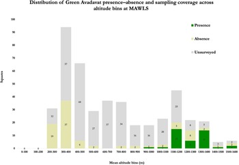
Presence/absence of Green Avadavats by altitude at MAWLS. As indicated in Methods, the lack of exploration and data in the 500–1,000 m elevation band reflects the inaccessibility of the areas.
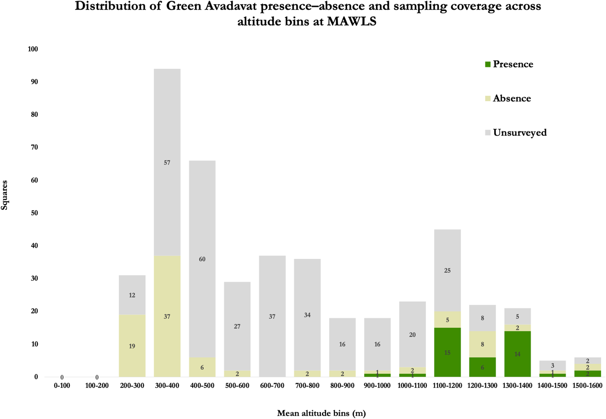
Figure 2. Long description
A stacked bar chart with the Y-axis labeled Squares ranging from 0 to 100 and the X-axis labeled Mean altitude bins in meters ranging from 0 to 1600. The legend indicates three categories: Presence (dark green), Absence (light yellow), and Unsurveyed (light gray).
Data trends from left to right:
* 0 to 200 meters: No data recorded.
* 200 to 300 meters: 19 absence, 12 unsurveyed.
* 300 to 400 meters: 37 absence, 57 unsurveyed.
* 400 to 500 meters: 6 absence, 60 unsurveyed.
* 500 to 600 meters: 2 absence, 27 unsurveyed.
* 600 to 700 meters: 37 unsurveyed.
* 700 to 800 meters: 2 absence, 34 unsurveyed.
* 800 to 900 meters: 2 absence, 16 unsurveyed.
* 900 to 1000 meters: 1 presence, 1 absence, 16 unsurveyed.
* 1000 to 1100 meters: 1 presence, 2 absence, 20 unsurveyed.
* 1100 to 1200 meters: 15 presence, 5 absence, 25 unsurveyed.
* 1200 to 1300 meters: 6 presence, 8 absence, 8 unsurveyed.
* 1300 to 1400 meters: 14 presence, 2 absence, 5 unsurveyed.
* 1400 to 1500 meters: 1 presence, 1 absence, 3 unsurveyed.
* 1500 to 1600 meters: 2 presence, 2 absence, 2 unsurveyed.
Presence is only recorded at altitudes above 900 meters, with the highest concentration between 1100 and 1400 meters.
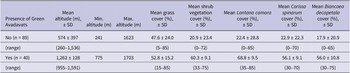
Table 4 summarises mean values for habitat measures for positive and negative squares, with shrub cover split by species. Squares where the avadavat were recorded tended to have higher proportions of all three shrub species, including both invasives.
Habitat characteristics of surveyed squares at MAWLS. Values are means with standard deviations (SD). Ranges are given in parentheses. Shrub cover (%) is the combined proportion of Lantana camara, Carissa spinarum and Biancaea decapetala. Individual shrub species cover values were estimated independently and are not additive due to spatial overlap
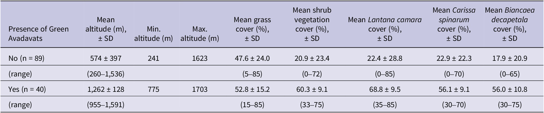
Table 4. Long description
The table contains nine columns: Presence of Green Avadavats, Mean altitude in meters plus or minus S D, Minimum altitude, Maximum altitude, Mean grass cover percentage plus or minus S D, Mean shrub vegetation cover percentage plus or minus S D, Mean Lantana camara cover percentage plus or minus S D, Mean Carissa spinarum cover percentage plus or minus S D, and Mean Biancaea decapetala cover percentage plus or minus S D.
Row 1: Presence No (n = 89). Mean altitude 574 plus or minus 397 (range 260 to 1,536). Minimum altitude 241. Maximum altitude 1623. Mean grass cover 47.6 plus or minus 24.0 (range 5 to 85). Mean shrub cover 20.9 plus or minus 23.4 (range 0 to 72). Lantana camara 22.4 plus or minus 28.8 (range 0 to 85). Carissa spinarum 22.9 plus or minus 22.3 (range 0 to 70). Biancaea decapetala 17.9 plus or minus 20.9 (range 0 to 65).
Row 2: Presence Yes (n = 40). Mean altitude 1,262 plus or minus 128 (range 955 to 1,591). Minimum altitude 775. Maximum altitude 1703. Mean grass cover 52.8 plus or minus 15.2 (range 15 to 85). Mean shrub cover 60.3 plus or minus 9.1 (range 33 to 75). Lantana camara 68.8 plus or minus 9.5 (range 35 to 85). Carissa spinarum 56.1 plus or minus 9.1 (range 30 to 70). Biancaea decapetala 56.0 plus or minus 10.8 (range 30 to 75).
Discussion
Surveys of Green Avadavats at MAWLS in March–August 2023 showed that the species was locally widespread towards the north and centre of the study area, with the two predictors most strongly associated with its presence being shrub vegetation cover and altitude. Although these two variables were strongly correlated, we suggest that both may play a role in explaining the species’ occurrence. The species was found in good numbers at high-elevation ranges at MAWLS and proved common above 1,200 m; up to 180 birds in multiple flocks were recorded in some squares. Mehra et al. (Reference Mehra, Sharma and Mathur2005) similarly recorded the birds between 900 and 1,500 m, most commonly above 1,200 m. Nevertheless, although squares were selected with the highest probability of detecting Green Avadavats (based on previous observations, and eBird and iNaturalist data), birds were only found in one-third of the squares surveyed. As previously reported (Lodhiya Reference Lodhiya1999; Mehra and Sharma Reference Mehra and Sharma2004; Mehra et al. Reference Mehra, Sharma and Mathur2005; Tiwari and Tiwari Reference Tiwari and Tiwari2005), these findings suggest a patchy local distribution, likely reflecting a restriction to areas where suitable shrub density, grass cover and elevation intersect, limiting the species to pockets of usable habitat.
The avadavat was not encountered in nine higher-altitude squares where it was usually found previously; it was, however, present in adjacent squares similar in habitat characteristics. Whether the absences were genuine, resulting from changes in local occupancy (for whatever reason), or false negatives owing to chance failures of detection, is not possible to judge. A positive correlation between occupancy and altitude was apparent, with bird presence concentrated exclusively in the upper elevational strata (Figure 2). From these results, the species’ altitudinal limit at MAWLS during the dry season lies between 775 m (lowest recorded elevation) and 1,703 m (highest recorded elevation). However, very few squares within the range of 500–1,000 m could be surveyed owing to access issues mentioned under Methods. Therefore, there remains some uncertainty as to the species’ true distribution and abundance at these altitudes.
Two caveats need to be issued concerning these results. First, following a recent trend at Mount Abu, unseasonal, brief but intense bouts of rain during the survey months (April–July) resulted in greater water availability and grass than usual, which could have affected the distribution of the birds during this study; consequently, water was not examined as a habitat component in the analysis. Second, as expected (e. g. Buckland et al. Reference Buckland, Marsden and Green2008), the amount of time spent surveying each square was strongly positively correlated with the likelihood of detecting avadavats. Greater time spent in a square may increase detection probability simply through increased opportunity to observe or hear the species, but it also indicates that the square was more difficult to traverse, owing to the rugged terrain and denser shrub vegetation cover. This in turn may introduce a bias by conflating effort with habitat complexity. To better manage this issue, future analyses could incorporate measures of habitat accessibility and vegetation density directly, or control for time spent per square to normalise detection probability across varying conditions.
Breeding data for the Green Avadavat in the wild are very scarce (see Collar et al. Reference Collar, Andreev, Chan, Crosby, Subramanya and Tobias2001). Nesting has not been observed at Mount Abu, but observations in the years 2018–2022 indicate that it may occur in response to the monsoon season in August–September, when flocks disappear and the species is much less in evidence (SZ pers. obs.). However, where breeding might occur is unclear. A previous study reported that the species is absent in Mount Abu during August–October (Tiwari and Tiwari Reference Tiwari and Tiwari2005), implying that the birds might descend to the foothills where agriculture is the dominant habitat. However, in recent years the avadavat has been found at higher elevations during these months (SZ pers. obs.), albeit spotted with relative difficulty and in low numbers. The birds are also present at higher elevations even at midwinter (December–January), when many juveniles are seen, suggesting considerable tolerance of sub-zero temperatures (SZ pers. obs.). Two factors might plausibly lie behind this circumstance: an apparent departure from the landscape owing to the adoption of much more discreet behaviour, and a genuine departure driven by the sudden availability of water in areas possessing the other key components of the species’ habitat. Since these considerations are not mutually exclusive, it may not be that all birds at higher elevations move downslope, just a significant proportion of them; and vice versa in the dry season. Unverified records on the eBird database exist in the lowlands and foothills, and local farmers and residents there claimed sightings during our surveys. Additionally, small lowland populations have been recorded in neighbouring Udaipur (Sharma et al. Reference Sharma, Koli and Sukhwal2012; eBird 2023), Rajasamand (Chhangani Reference Chhangani2002; Sharma et al. Reference Sharma, Koli and Sukhwal2012; eBird 2023) and northern Gujarat (eBird 2023).
It therefore seems likely that the key element in the avadavat’s distribution and abundance at Mount Abu is not elevation per se but the water which the mountain’s elevation draws from the sky. Not only is water vital for the growth of the grass on whose seeds the avadavat depends, but it is also needed by the birds to help digest those seeds (Payne Reference Payne, del Hoyo, Elliott and Christie2010). Although percentage grass cover was the predictor with the smallest effect on the species’ presence, it was still important and significant in our model: squares where Green Avadavats were recorded had at least 15% grass cover. In addition to using grass as a food source, the birds also use it for cover and nesting (Collar et al. Reference Collar, Andreev, Chan, Crosby, Subramanya and Tobias2001; Sajan and Mohapatra Reference Sajan and Mohapatra2018). Even so, in 2023 there was evidence of grazing in squares where Green Avadavats were detected, and it was notable that unlike certain estrildids in MAWLS (including Red Avadavat Amandava amandava present in the foothill areas), which tended to be seen in areas with longer grass, Green Avadavats foraged in areas of short, grazed grass patches bordered by shrub vegetation (SZ pers. obs.).
The importance of shrub vegetation to the avadavat is strongly apparent in this analysis, presumably owing to its function as easily reached cover adjacent to foraging areas. There is significant cover of Lantana camara, Biancaea decapetala and Carissa spinarum in all forest blocks, especially over 700 m. Although Lantana camara and Biancaea decapetala are invasive species and can cause biodiversity loss (Kohli et al. Reference Kohli, Batish, Singh and Dogra2006; Global Invasive Species Database 2025), leading to demands for its large-scale removal (Tiwari and Varu Reference Tiwari and Varu1999; Sharma et al. Reference Sharma, Raghubanshi and Singh2005), the clearance of these and other shrubs (undertaken by the local forest department in recent years without success) should be approached with caution at Mount Abu, and undertaken as an experiment to test the degree of dependence the avadavat has on them (individually and collectively) for roosting and cover, and very possibly also for breeding.
Trapping by local communities for medicinal use has been identified as a threat at Mount Abu (Mehra et al. Reference Mehra, Sharma and Mathur2005, Tiwari and Tiwari Reference Tiwari and Tiwari2005; hence Payne Reference Payne, del Hoyo, Elliott, Sargatal, Christie and de Juana2021), but members of these communities, questioned during fieldwork, were unaware of this, and there is no evidence of the practice occurring at MAWLS currently or in the recent past. However, habitat loss and degradation, including clearance of shrub vegetation and the effects of unmanaged tourism, are significant ongoing threats at MAWLS (Mehra et al. Reference Mehra, Sharma and Mathur2005; Sangha and Devarshi Reference Sangha and Devarshi2006; Zutshi Reference Zutshi2020, Reference Zutshi2023; BirdLife International 2004). Despite the Eco-sensitive Zone (ESZ) declaration at Mount Abu, sprawl from the town and surrounding villages is a serious problem. Since 2023, the local administration has permitted commercial constructions on agricultural land around Oriya village (1,350 m), a prime location of the avadavat, contrary to ESZ guidelines and local regulations. Similar developments and ineffective enforcement of ESZ regulations are affecting the villages of Achalgarh, Delwara, Jawai, Salgaon, Dhundayi, Torna and Aarna (all in the range 1,100–1,550 m). In addition, changing climatic conditions are increasing the risk of wildfires at the sanctuary (Zutshi Reference Zutshi2022), pesticides are becoming more prevalent in agriculture in the area (Sajan and Mohapatra Reference Sajan and Mohapatra2018), and local communities are insufficiently aware of the great importance of Mount Abu to the Green Avadavat (Zutshi Reference Zutshi2020, Mehra and Sharma Reference Mehra and Sharma2004).
On the evidence gathered here, we recommend a new phase of research and conservation for the Green Avadavat at Mount Abu. A programme of colour-ringing and mist-netting in various parts of the sanctuary would yield valuable information about movements and survival. Focused studies of diurnal activity would identify key foods, behavioural routines and habitats. Monitoring the response of the species to the removal of invasive vegetation in particular areas would clarify the value of cover to the maintenance of its populations. The discovery of nests—perhaps involving a citizen science initiative—would enable vital data on breeding ecology and productivity to be gathered. A local pride campaign could be directed at communities and local leaders for their stewardship of the species, coinciding with a review of the wildlife sanctuary’s management plan, in which a clear aim should be to maintain optimal habitat conditions, as confirmed by further research, for the long-term preservation of the Green Avadavat.
Acknowledgements
The study was supported by Zoologische Gesellschaft für Arten- und Populationsschutz e.V. (ZGAP Germany), Idea Wild USA, Re:wild USA and National Finch and Softbill Society (NFSS USA). We are very grateful to Rajasthan Forest Department, in particular Arijit Banerjee (PCCF and HoFF Rajasthan Forest Department) and K.C.A. Arun Prasad (APCCF Wildlife Rajasthan Forest Department), for permission to work in the wildlife sanctuary and to publish the study (F.19 (Report)permission/cwlw/2025/03851). This study was made possible thanks to the assistance of Teja Ram Rana in fieldwork, Dr. Kumaraswami M (NCCR, Chennai) for mapping; and the cooperation of the Mount Abu Forest Department. Suggestions and support from the late Dr. G.V. Reddy (former PCCF Rajasthan Forest Department), Gajendra Singh Khimsar (former Forest Minister Rajasthan), Balaji Kari (former DCF Mount Abu) and Sammy Mathur proved extremely valuable, and two referees offered most helpful advice.
Competing interests
The authors declare that they have no competing interests in publishing this manuscript.




 Open access

