NORTHUMBERLAND
(1) Corbridge, Playing Field (NY 984 650):Footnote 33 geophysical survey revealed a probable road surface and structures, followed by a brief evaluation. Excavation revealed Roman archaeology underlying the topsoil and a layer or relict ploughsoil containing unstratified Roman ceramics. A paved road running east–west was confirmed, and an external wall of a building was found east of the revealed road, positioned north of the road. A probable hearth or furnace was evidenced against the internal wall of the building, though the trench size restricted recovery of the full extent of the building.
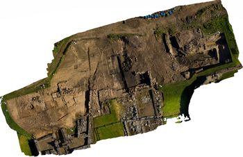
(2) Vindolanda, (a) outside the third-century fort (NY 769 663):Footnote 34 2019 was the second year of a five-year research excavation at Vindolanda: Understanding Communities and Identities: The Severan Fortlet and Roundhouse Complex at Vindolanda. Work continued in an area of the site currently covered by the third-century extramural settlement, between the north-western corner of the last stone fort, the third-century bath-house and the modern line of the Stanegate Road (fig. 2). Excavations expanded to the east and west of the trenches explored in 2018Footnote 35 and are presented in reverse-chronological order.
Vindolanda: an aerial view of the excavations to the north-west of the last stone fort. (3D image created by Adam Stanford)

ParaIndThe remains of the 17th- to 19th-century farmhouse, Smith's Chesters, was located, surviving as an inverted rectilinear foundation trench, cut through the natural boulder clay subsoil of the hillside and backfilled with ash, rubble and farming debris. The building was demolished by the Clayton family in the 19th century and had been almost entirely removed from its landscape. The area to the south of the farmhouse was covered by a cobbled yard which in turn had been constructed over the partial remains of several third-century extramural domestic structures as well as the outlet drain for the bath-house toilet block. The material from the outlet drain contained several Roman beads and pottery, and bone from the third-century occupation. The soil fill from the drain was blackened by soot and on further analysis conducted by Oxford and Cambridge Universities was shown to contain ample evidence of parasites from the Roman use of the toilet block. Further analysis is being undertaken of this evidence.
ParaIndWest of the toilet drain, also dug into the natural clay of the bank and an earlier backfilled fort ditch, were the remains of a small square-shaped heated room with an ornamental door and aqueduct below the floor. Initial interpretation of the structure suggests an Antonine or mid-second-century date for this building. Its purpose is unknown, but its location, shape and attributes would not be out of keeping for a small shrine or heated cult room.
ParaIndEast of the bath-house toilet drain the excavations continued to investigate the large series of Antonine fort ditches, some 20 m in breadth, running in a north–south orientation that were partially explored in 2018. The ditches produced more leather, animal bone and the partial remains of a juvenile skull. Two teeth remained in situ and are awaiting DNA and isotopic analyses.
ParaIndThe Antonine ditches had been cut through earlier defensive works dating from Vindolanda period I to period IV, c. a.d. 85–105, the northern defences of the pre-Hadrianic forts. Both ramparts and ditches proved to be informative. The ramparts were constructed in three different styles and utilised a variety of woods and other materials in each construction phase, showing a distinct progression in Roman engineering techniques. The associated northern fort ditches were broad, 6 m across their top, and their contents were preserved by a mixture of anaerobic and waterlogged deposits, producing over 30 oak tent pegs, fragmentary ink and stylus tablets, and many well-preserved shoes and animal bones. The bases of the ditches had been filled by loose rubble and more than 1.5 m of clean grey silt. This silt appears to have been washed into the ditches in a single flood event rather than over a sustained course of time, suggesting a reason for the abandonment of the defensive line used until c. a.d. 105. An area north-west of the ditches was also scoured by floodwater to a depth of 3 m on the steeply sloped hillside through the natural clay. This land damage was subsequently backfilled with turf, possibly using material from the abandoned ramparts.
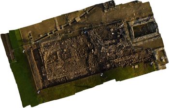
ParaInd(b) inside the third-century fort (NY 766 033): excavation of the area to the south of the granaries encountered in the south-western quadrant of the fort provided evidence for the last ancient occupants of Vindolanda (fig. 3). These included post-pits and pads for timber-built structures and the broad stone foundations of a partially preserved apsidal structure, dating to between the sixth and eighth centuries and tentatively identified as a church. The church had a west-facing apse, partially constructed over a fourth-century barrack and the road to the south of the granaries. Within and surrounding the structure were several early Christian carvings, ranging from simple crosses and crudely carved figures on stones to a more complex fragmentary and poorly preserved lead vessel with numerous inscribed symbols decorating its external and internal surfaces. Symbols identified include numerous Chi-Rhos, crosses, ships, fish, whales, angels and the stylised image of a priest.
Vindolanda: the church foundation and other buildings within the south-western quadrant of the last stone fort at Vindolanda. (3D image created by Adam Stanford)

ParaIndBelow the church and to its west, well-preserved remains of drains, roads and the last Roman period structures were encountered. Excavations will continue in this area during 2020 with the aim of reaching the preserved remains of Severan period roundhouses below the later buildings.