

TOPOGRAPHICAL–HISTORICAL BACKGROUND
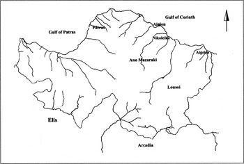
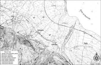
A temple of the Geometric period was uncovered in 2004 in a rescue excavation conducted by the 6th Ephorate of Prehistoric and Classical Antiquities (EPCA) in the village of Nikoleika near Aegion (Kolia and Gadolou Reference Kolia and Gadolou2011; Kolia and Gadolou Reference Kolia and Gadolou2007). The site lies beside the old national road, west of the modern course of the River Kerynites (Figs. 1, 2 no. 1). This article presents an account of the excavation seasons of the years 2004–9, as well as an analysis of the architecture of the apsidal temple and of the cult practices related to the brick-built altar.
Map of Achaea.

Topographical plan of the area west of the River Kerynites.

East of the River Selinous and west of the Kerynites lay the chora of ancient Helike, a city destroyed by earthquake in 373/372 bc. According to Pausanias (7.24.5), Helike lay east of the Selinous and 40 stades (c.7.2 km) from Aegion. The Geometric sanctuary at Nikoleika, east of the Selinous and 7.5 km from Aegion, was therefore within the chora of ancient Helike. Homer refers to ‘broad Helike’ and counts it, with Pellene, Gonoussa (Donoussa), Hyperesia (Aegira) and Aegion, among the cities of the kingdom of Agamemnon which sent ships to Troy (Iliad 2.575). There are also two references in the Iliad to the renowned sanctuary of Poseidon Heliconius, located in Helike (Iliad 8.203; 20.404). According to Strabo, the founder-hero (oikistes) of Sybaris in South Italy was Οισ< …> or Is of Helike (Strabo 6.1.13 [C 263]; Rizakis Reference Rizakis1995, 297, no. 515). Many ancient authors, even in late antiquity, refer to the destruction of Helike and its submersion beneath the waves, an event that quickly acquired mythical proportions.Footnote 2 Neighbouring Aegion seized this opportunity to capture the territory of Helike, and became the most powerful city in Achaea as well as the religious and political centre of the First Achaean League, assuming the status of the submerged city (Papachatzis Reference Papachatzis1980, 148–9; Petropoulos Reference Petropoulos and Panitsas1990, 510–13; Katsonopoulou Reference Katsonopoulou and Rizakis1991, 227–34; Reference Katsonopoulou, Katsonopoulou, Soter and Schilardi1998a, 47–52; 2002, 205–15). Helike was never refounded and its former territory remained part of Aegion into Roman times (Strabo 8.7.5). However, its exact location is still elusive (Pausanias 7.25.4; Strabo 8.7.5 [C 387]; Bölte Reference Bölte1912, line 2858; Xinopoulos Reference Xinopoulos1912, 32).
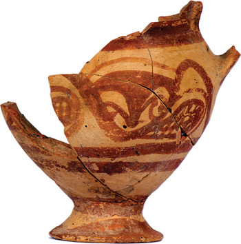
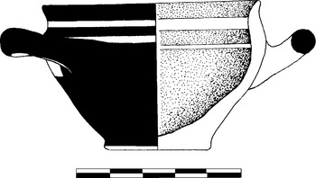
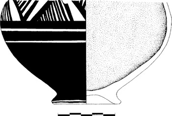
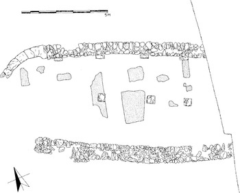
The Geometric temple was found some 400 m from the foot of Kallithea or Psoriarou Hill, where richly furnished Late Helladic IIB–Late Helladic IIIC graves have previously been excavated (Petropoulos Reference Petropoulos1995b, 233–6; Reference Petropoulos1996, 240; 2006, 37–44; Reference Petropoulos, Deger-Jalkotzy and Zavadil2007, 254, 256–7) (Fig. 2, no. 2). These graves form part of an extensive chamber tomb cemetery considered by their excavator, Michalis Petropoulos, to belong to Mycenaean Helike (Petropoulos Reference Petropoulos1995b, 233–6; Reference Petropoulos and Greco2007, 253–4). His view is further supported by the discovery in 2009 of a Mycenaean settlement some 250 m from the Geometric temple, at the foot of the hill where the cemetery lies. This excavation (trial trenches opened by the 6th EPCA in the course of the construction of the new Athens–Patras motorway) (Fig. 2, no. 3) is still in progress, but preliminary evidence indicates that the settlement covered an area of over one hectare, with signs of habitation dating back at least to the Late Helladic II period (Fig. 3). Also important for research in the sanctuary at Nikoleika is the discovery of a further apsidal Geometric building in trial trenches opened in the adjacent building plot to the northeast of the Geometric temple. It is not yet known whether this building belonged to the sanctuary or to a settlement that extended around the temple.
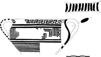
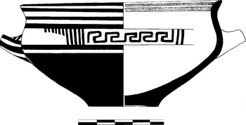
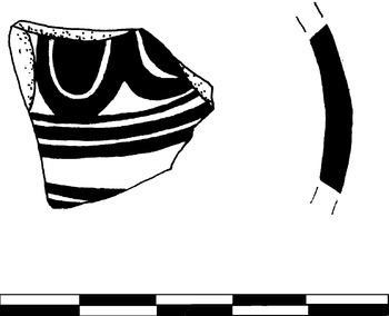
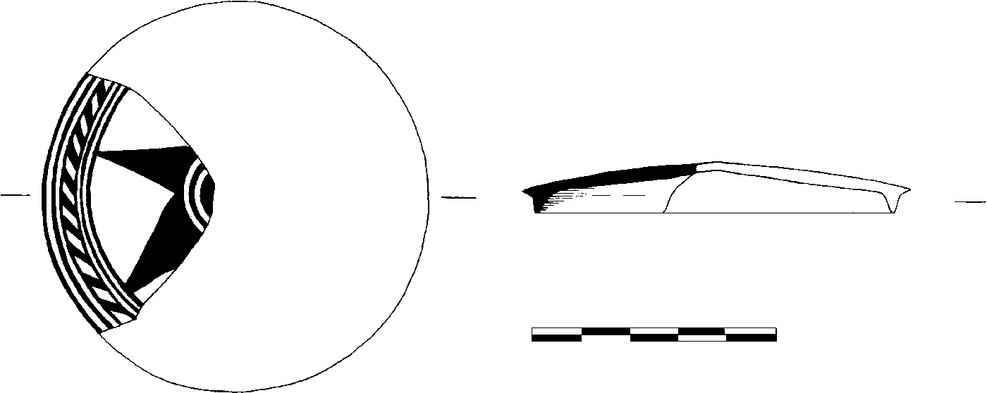
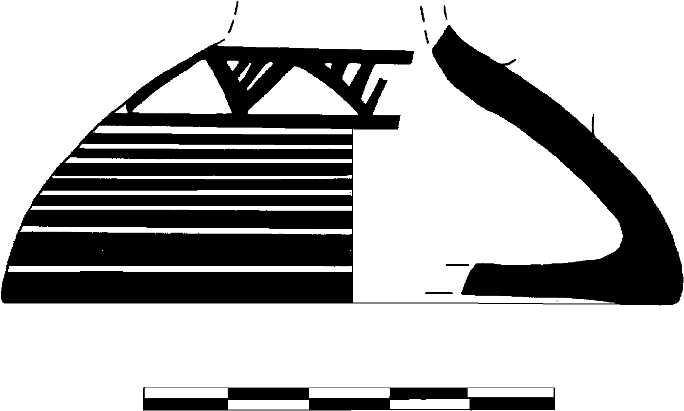
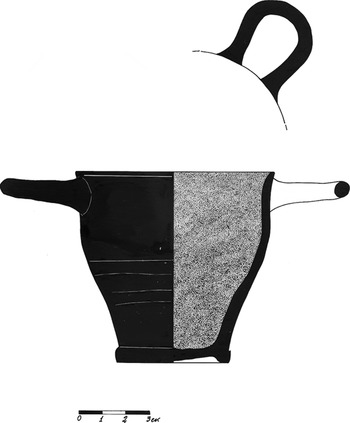
Kylix from the excavation of the Mycenaean settlement south of the Geometric temple, Aegion Archaeological Museum AMA 2892.

Inland and further to the west, on Brouma or Agios Georgios Hill at Keryneia (an outlier of the mountainous massif of Prophitis Ilias), ancient remains have been noted and a Hellenistic temple excavated (Petropoulos Reference Petropoulos1985, 123–7) (Fig. 2, no. 4). There are scattered ashlar blocks and remnants of retaining walls at various points on the hill, and a few Mycenaean sherds have also been found. In the wider area, at Diaselo near Prophitis Ilias, Archaic graves have been excavated (Papapostolou Reference Papapostolou1978, 100). Clearly, this was a site of human activity from prehistoric to Hellenistic and Roman times. The position of the hill in the south of the plain, in the centre of the chora, and its steep, natural fortification, indicate that it was the acropolis of Helike.Footnote 3 At the foot of the crag, the 6th EPCA is currently excavating an extensive Early Helladic settlement (Fig. 2, no. 5), and a second Early Helladic settlement (possible destroyed by earthquake) is being investigated by the Helike Project in the plain to the north of Rizomylos (Fig. 2, no. 6) (Katsonopoulou Reference Katsonopoulou and Greco2002, 208–9). Just to the southwest of this Early Helladic settlement (on the Klonis plot) are the remains of a Late Roman farmhouse (Katsonopoulou Reference Katsonopoulou, Katsonopoulou, Soter and Schilardi1998b, 125–45; Petropoulos Reference Petropoulos, Kazakou and Zapheiropoulou2006, 44–8) (Fig. 2, no. 7). Graves and a probable Late Roman farmhouse have also been excavated at the northwest edge of the village of Nikoleika (Kolia Reference Kolia2002; Katsonopoulou Reference Katsonopoulou and Greco2002, 210) (Fig. 2, no. 8), while in 2006 the 6th EPCA investigated part of a Roman cemetery to the north of the Geometric temple (Kolia Reference Kolia2006). Lastly, even further west, near the Selinous river, at Mouries, the Helike Project is currently excavating an Early Hellenistic building complex, possibly a craft or industrial installation (Katsonopoulou Reference Katsonopoulou, Katsonopoulou, Soter and Koukouvelas2005, 33–6). In sum, this archaeological evidence indicates continuous human occupation of the narrow plain between the Selinous and Kerynites rivers from the Early Helladic period to the present, exploiting the fertile alluvial soils despite the catastrophic consequences of frequent seismic activity.
THE EXCAVATION
A) The apsidal temple
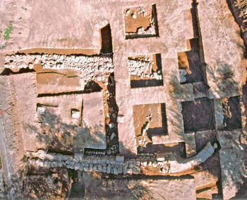
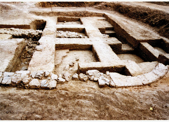
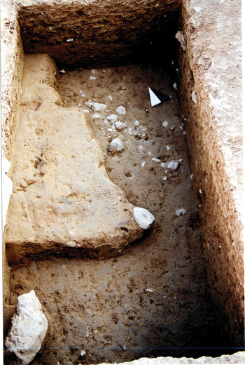
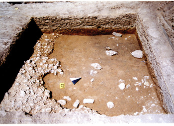
The temple was discovered during the removal of earth in preparation for construction on a plot owned by Athanasios Komninos and Paraskevi Karachaliou in the centre of the village of Nikoleika, at a point where no antiquities had previously been found (Figs. 4, 5). Excavation commenced in 2004 as a rescue operation, and was continued systematically in subsequent years. Work focused on uncovering the building (which is identified as a temple on the basis of its dimensions and form, without internal partitions [Mazarakis-Ainian Reference Mazarakis-Ainian1997, 388], and the associated portable finds). To date, most of the apsidal building within the boundaries of the Komninos–Karachaliou plot has been fully excavated, although its west edge has not been investigated as it extends into a neighbouring plot. Some trenches opened outside the temple yielded important finds, but a large part of the plot has not been explored because its expropriation is still pending.
Aerial photograph of the temple.

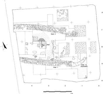
Ground plan of the excavation.

The south wall of the temple (wall 1), 12 m in length, was revealed at a depth of –2.67 m (in the central part) to –2.97 m (in the east, with the semicircular prostasis) below the surface of the old national road.Footnote 4 Wall 1 is preserved to a relatively great height because of the steep northwards slope of the ground from the old national road towards the temple. Two trenches were then opened – inside wall 1, and transverse to its middle – to confirm the dimensions and condition of the building. When its size was ascertained, a grid was marked out for its systematic excavation.
The building is oriented east–west, with the entrance on the east side. It has been revealed for a length of 12 m, while its width in the east is 6.7 m and in the west 7 m. The fill covering is no more than 1.3 m thick in the east part of wall 1 and 0.7 m at its west end, and consists of ochre-brown argillaceous soil. The north wall of the temple (wall 2) was found some 5–5.3 m from the south wall, and traced for 11.5 m. Because of the slope of the ground, wall 2 survives to a lower height than wall 1 and parts of it are dislodged, presumably by later cultivation (see e.g. grid squares Γ2 and Γ4 in Fig. 5), while there is no trace of the semicircular east end. Both walls 1 and 2 display a slight swelling on the outer and the inner side which is more pronounced on wall 2.
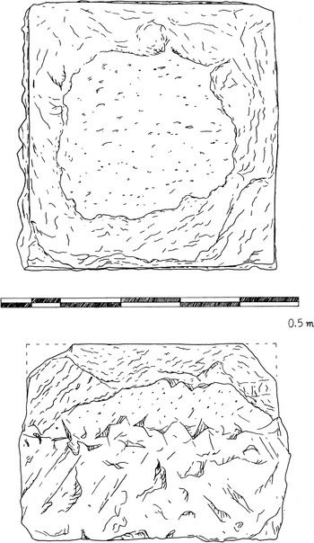
Inside the temple, approximately on its longitudinal axis, stood a row of wooden columns on stone bases (Figs. 6, 7). Three quadrilateral sandstone bases are preserved in the central and the west part of the temple at a depth of –2.8 to –3 m. A fourth base was probably removed from the east end of the temple in later times. The intervals between the bases are 1.75 and 2.42 m respectively from east to west, and their distance from the temple walls varies (none is situated exactly on the axis of the temple). Up to 0.34–0.35 m high, they are 0.45 m square at the base decreasing to 0.42 m at a height of 0.18 m, thus forming a small ridge around the perimeter. From this point upwards they were visible, whereas the lower part was sunk into the floor. The bedding surface of the wooden column (c.0.33 m in diameter) is preserved on top of the first base from the east.
Drawing of the column base in the baulk of square Β2.

View of the west flank of squares Α2, Β2, Γ2; the column base is visible.

Along the interior of the south wall were four rectangular bases, also of sandstone (Fig. 8), which supported wooden piers to buttress the temple walls. Corresponding bases will also have existed on the north wall. From east to west, the bases were found at a depth of –2.8 m to –2.86 m. They range in length from 0.48 m to 0.5 m, and in width from 0.175 m to 0.22 m, and are 0.25 m high. They are bedded at a depth of c.–3 m upon the temple floor, at a slightly higher level than the column bases, with the exception of the fourth pier base which is founded in the floor. The column bases correspond more or less to the pier bases.
Pier base in square Β4 and the west part of wall 1.

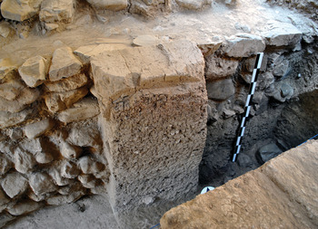
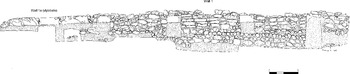
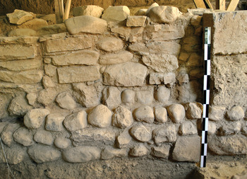
The south wall (wall 1) displays significant differences in the course of its construction. At the arc-shaped east end it consists of neatly hewn ashlar blocks of sandstone (wall 1a) (Figs. 9, 10). Initially this part was thought to be a remnant of the apse, but its distinct function in relation to the long walls of the temple is demonstrated by their different masonry. Wall 1a, of ashlar blocks, is just 0.25 m high, while the south long wall is of roughly-worked small or medium-sized stones and rubble, and is more than 1 m high. The blocks in wall 1a range in length from 0.74 to 0.81 m and in width from 0.5 to 0.78 m at the west end, where wall 1a joins wall 1.
Face of the south wall of the temple (wall 1) and of the stylobate of the prostoon (wall 1a).

View of the temple from the south. Visible is the different construction of wall 1a (stylobate of the arc-shaped prostoon) and wall 1.

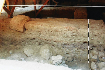
Wall 1 is of more regular construction than wall 2. It consists of slab-shaped and roughly-worked or unworked pieces of schist, sandstone and limestone in two courses, with smaller stones and earth in the interstices. It ranges in width from 0.72 m to 0.8 m (Figs. 9, 11) and its maximum preserved height at the east and west ends (east of the first pier base and west of the fourth) is 0.76 m and 0.69 m respectively. The lowermost course, constructed of relatively small river pebbles, protrudes 0.08–0.21 m beyond the face of the wall. The foundation of wall 1 is at a depth of –3.6 m at the east end and –3.51 m at the west (Fig. 8). By contrast, between the second and third pier base, wall 1 is 1.16 m high on the north face, since its foundation is at a depth of –3.81 to –3.94 m. Its lowest part, at a depth of –3.45 m, protrudes 0.14–0.2 m beyond the face, and is built of river pebbles and small unworked stones (Figs. 9, 11). Excavation outside wall 1 in square Α3 showed that there is no section built of river pebbles in the lower part of the south flank of the wall: here the foundation lies at –3.68 m, i.e. c.0.13/0.26 m higher than on its north flank.
Face of the south wall of the temple (wall 1), between the second and third pier bases.

The lower part of wall 1 was initially assigned to an earlier phase due to its different construction and because it projects beyond the face (Kolia and Gadolou Reference Kolia and Gadolou2007). However, it is probably a retaining wall towards the north, where the ground slopes markedly. This is supported by the fact that the lower, projecting part of wall 1 barely follows the curvature of the overlying part and was not found on the outer flank of wall 1. Indeed, it may consist of just one course of stones towards the north, as is seen in its upper part distinguishable between the second and the third pier base. It is not fortuitous that this ‘retaining wall’ is encountered after the second pier base, where the ground level was lower in the earlier phase due to the presence of the altar, and where the surface had to be raised appreciably for the construction of the temple. It seems that because of its sanctity the altar was preserved to its full height and filled with earth.
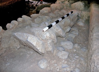
Wall 2 was revealed for a length of 11.5 m and continues westwards into the adjacent plot (as does wall 1) (Fig. 12). Its upper surface was identified in the east at a depth of –3.36 m and in the west at –3.07 m, while its bedding was found at a depth of –3.6 m at the east end and –4.01 m in the centre. The greater depth of the foundation of wall 2 in comparison with wall 1 must be related to the northwards slope of the ground. At its east end (in square Γ1), wall 2 is only 0.24 m high, at its midpoint it is 0.73 m and in the west it decreases to 0.3 m. Its construction differs from that of wall 1: it consists of small and medium-size unworked stones, mainly river pebbles, densely packed rather than laid in two courses. On both faces, and the exterior in particular, the stones (conglomerate and limestone) are bigger. There is earth between them but no flat stones (in contrast to wall 1). The construction of wall 2 is closer to that of the lower part of wall 1. The wall ranges in width from 0.78 to 0.92 m in its upper part, increasing to 1.02 m in the lower. In square Γ3 and west into Γ4 it is founded in the layer of river stones, while to the east, in squares Γ2 and Γ1, it is founded in the grey-brown soil. Its east end consists of two conglomerate boulders (its foundation at this point). Outside wall 2, in squares Γ3–Δ3, a course of small rounded river pebbles was revealed at a depth of –3.91 m, projecting 0.2–0.22 m from its north flank. These are the same as the stones projecting in the bedding of the north flank of wall 1, between the first and the second pier base. This course is up to 0.1 m high and was covered by yellow sandy soil containing very few sherds. The same course was also identified in the bedding of the north flank of wall 2 in square Γ2 at a depth of –3.58 m (as the east part of wall 2 is founded higher: Fig. 13). There is a good parallel for the projection of the foundation beyond the face of the walls in the temple of Artemis Aontia at Ano Mazaraki, although there the foundation and the temple walls are built mainly of limestone slabs, a material abundant in the area (Petropoulos Reference Petropoulos1992–3, 145, fig. 4).
The north wall of the temple (wall 2).

The projecting stones at the base of wall 2 in square Γ2.

The floor of the apsidal temple, of reddish beaten earth, survives in fragmentary condition. Large parts were found around the column bases at depths from –3.13 to –3.24 m, and 0.06–0.1 m thick. At the centre of the temple, however, east of the second column base, it is markedly elevated and up to 0.19 m thick. At this point an area of floor measuring 1.88 × 1.4 m was found at a depth of –3.06 to –3.10 m.
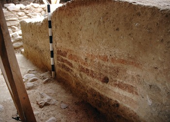
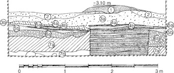
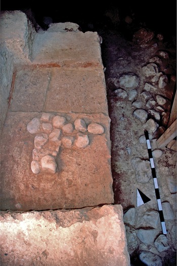
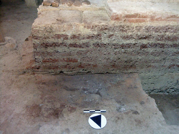
In 2006, the mudbrick altar was revealed in the approximate centre of the later apsidal temple (squares B3–Γ3). Immediately below the raised floor of the temple and the two overlying layers of clay in the lower area (which were initially thought to be floors), lay the east part of a square brick-built construction, 0.59 m high and 1.26–1.3 m wide (Fig. 14). Its east end, 0.2–0.25 m long, had been damaged and the courses of mudbrick were crumbly. Only the lowest course was stable: this was 0.06 m thick, uncovered at a depth of –4.06 m, and bedded at –4.12 m. The square altar consists of six successive courses of reddish brown mudbricks, 0.08–0.06 m thick, alternating with an equal number of thinner layers of clean buff soil, 0.04–0.05 m thick, thus alternating colours (Figs. 14, 15). In the northeast part, the upper course was of brownish red mudbricks in the shape of irregular quadrilateral slabs: the trapezoidal mudbrick at the northeast corner is 0.49 m long and 0.47–0.54 m wide, with a 0.03–0.04 m-wide groove at the point of contact with the contiguous mudbrick to the west (Fig. 16). The mudbricks are usually gritty in texture with a hard surface, solid and porous, while some are mottled sandy yellow in places. The surface of the brick-built altar is preserved at a depth of –3.59 m, and bedded in dark brown earth with gravel on its east flank, while north and east of it the contemporary floor was found at a depth of –4.14 to –4.16 m. A fine layer of yellow soil, devoid of sherds which covered the southeast part of this surface, contained the remains of a rubble construction forming an angle with two irregular small sides 0.6 and 0.46 m long (Fig. 16). This construction, as the surface of the mudbrick altar, was covered by the lower layer of reddish clay (‘floor 1’).
East face of the altar in square Β3.

Stratigraphy of the face of the altar in squares Β3–Γ3. 1: temple floor, 2: yellowish brown with gravel, 3a: pale yellow with gravel, 3b: pale yellow with traces of incineration, 4a: clayey layer, 4b: yellow brown, 5a: clayey layer, 5b: yellow under-layer, 6a: grey with traces of yellow soil and stones, 6b: grey, 7a: yellow sandy, 7b: yellow brown sandy.

The surface of the altar with the construction (?) of unworked stones.

The north flank of the brick-built construction, which extends along the baulk in squares Β3/Γ3 and Β4/Γ4, was uncovered in 2008 (Fig. 17). Of overall length 2.33 m and height 0.59–0.6 m, its surface was found at a depth of –3.63 m, slanting slightly to the west. On the basis of the finds, the excavation data, and the square form of the construction, this is interpreted as an altar antedating the apsidal temple. East and north of the altar, a floor of beaten reddish brown earth with gravel and small stones was found at a depth of –4.14/–4.16 m in Β3 and –4.18/–4.205 m in Γ3–Γ4. It is contemporary with the brick-built construction, since the lowest brick course is bedded at this depth. On the floor east of the altar were a fragment of a cooking pot with traces of burning, lumps of clay and one animal bone. The floor on the east flank of the altar and in square Γ4 was destroyed, nor does it continue to the south where there is pure buff sandy soil devoid of artefacts.
View of the altar from the northeast.

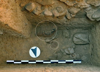
The removal of a small baulk in square Γ3 revealed intense traces of burning in place of the floor. Cleaning of these traces revealed an irregular cutting in the floor along the north flank of the brick-built altar (length: 0.7 m, width: 0.48 m). An earlier floor of black-grey clay was identified here at a depth of –4.215 m (Fig. 18). Two burnt coarse sherds and a handful of burnt bones were collected from its surface. The two floors are essentially in contact, since the brownish red floor was laid exactly on top of the earlier floor which continues beneath it and the altar; the burnt floor is thus earlier than the altar.
The earlier floor with incinerations, north of the altar in square Γ3.

B) Stratigraphy (Figs. 7, 14, 15, 20)
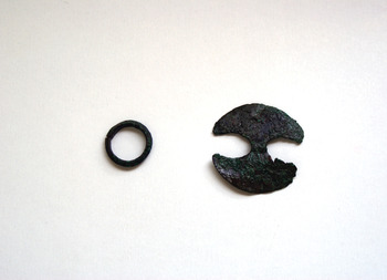
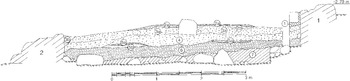
The temple was covered by hard, brown-yellowish argillaceous soil which contained a very few Late Geometric and Early Archaic sherds. Under this layer lay the temple floor, of reddish beaten earth, at a depth of –3.06 to –3.24 m. Below the floor, over the entire area of the building, two successive layers are encountered: a) of yellowish brown, rather hard, argillaceous earth containing gravel, and b) of yellow, paler earth, also argillaceous, hard and containing gravel. These under-layers for the floor range in thickness from 0.15 to 0.25 m. The column bases are bedded in the second layer and are covered to about half their height by the first, while the arc-shaped end of wall 1 (wall 1a) is founded in the first layer (Figs. 7, 20). The yellowish brown layer yielded a few sherds, mainly monochrome or with banded decoration and some with decoration of Thapsos type. There were rather more sherds of the same types in the second layer. Several minor objects were recovered, notably fragments of terracotta wheels and of two iron daggers, part of a bronze chain and bronze beads. In some places the lower part of the pale yellow layer was coloured grey by ash. Outside wall 2, in the pale yellow layer, was a cache of mostly metal artefacts – a bronze bead, ring, pin and miniature figure-of-eight shield, plus one fragmentary iron object and a glass-paste bead (Fig. 19).
Bronze miniature shield ΑΜΑ 881 and ring ΑΜΑ 880 from the pale yellow layer north of wall 2.

Stratigraphy of the west face of squares Α2–Γ2 in the interior of the temple, scale 1:20. 1: pale brown with gravel, 2a: temple floor, 2b: yellow under-layer, 3a: yellowish brown with gravel, 3b: pale yellowish brown, 4: pale yellow with gravel, 5a: clayey level, 5b: yellow under-layer, 6: grey, 7: yellow sandy with stones.

Under these layers, approximately in the centre of the temple, two successive thin clayey layers, ranging in thickness from 0.075 to 0.02 m, were identified at a depth of –3.45/–3.5 m and –3.54/–3.63 m respectively and initially interpreted as floors. The upper layer is of brownish yellow beaten earth with traces of red clay and sparse gravel, and the lower of brownish red clayey earth (Figs. 14, 15). Sandwiched between them was pure yellow earth without sherds. These ‘floors’ are solid in most of square Β3, in the east part of square Β4 and at the south edge of squares Γ3 and Γ4. Indeed, in square Β3, east of the second column base, both are slightly raised by 0.05/0.06 m. They do not touch any wall. They were found in extremely fragmentary condition in the squares around Β3 and Β4, essentially as large pieces of clay lacking the cohesion and stability to be considered regular floors. In 2008, the west side of the lower ‘floor’ was identified in square Β4. This is straight and coincides with the front of the west flank of the brick-built altar, which the so-called ‘floors’ cover and essentially seal (Fig. 21). Consequently, these layers are not floors of two earlier building phases, as initially presumed (a presumption supported neither by the stratigraphy nor by the dating of the pottery), but are rather a kind of covering of the altar, the most numinous point of the locus sanctus. This view is reinforced by the fact that the floor of the apsidal temple is also markedly elevated exactly above the altar and east of the second column base (Fig. 15).
Clayey layer over the altar, in its northwest corner.

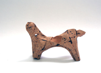
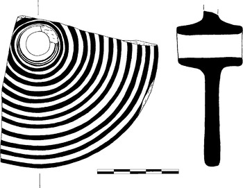
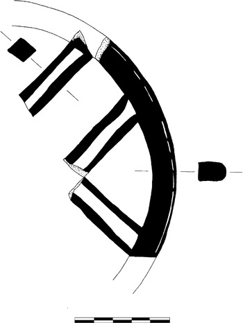
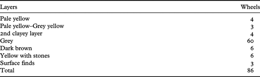
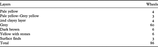
In squares Β3 and Β4 the brick-built altar was revealed under the ‘floors’ (Figs. 14, 15). The stratigraphy around the altar is the same: under the traces of ‘floors’ identified, or under the pale yellow layer, the grey–greyish brown layer with traces of incineration was excavated. These traces were more pronounced in squares Γ3 and Γ2, and less so in square Β3 south of the altar. The grey layer was found in contact with the altar and extends to the east and west of it, as well as to the north and south where it is delimited by the temple walls. To the north and east of the altar its thickness ranges from 0.3 to 0.4 m, while to the south, towards wall 1, it diminishes to 0.14 m. This layer included distinct traces of burning, broken animal bones (cooked or burnt), numerous small or medium-sized unworked stones, lumps of clay and copious objects: broken vases and sherds (mainly drinking vessels and cooking pots), horse figurines, parts of terracotta architectural models, one stone seal and several metal objects (bronze beads, rings and pins, iron daggers, and one small gold bead) (Figs. 22–7). The most characteristic finds, however, are 60 terracotta wheels, either disc-shaped with a pierced axle at the centre or with spokes (Table 1, Figs. 28 and 29).
Terracotta horse figurine from the grey layer ΑΜΑ 2299.

Skyphos ΑΜΑ 1956.

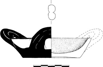
Three-handled plate ΑΜΑ 2890.

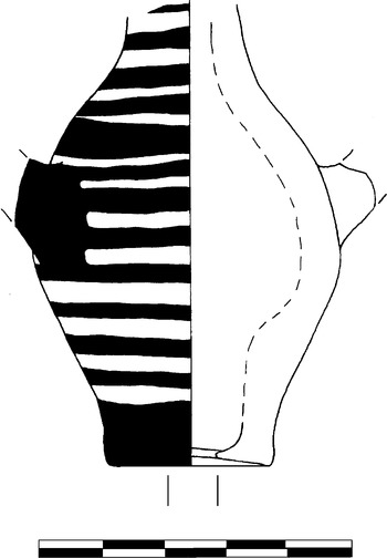
Amphoriskos ΑΜΑ 2308.

Cooking vessel (plate) ΑΜΑ 2891.

Kantharos ΑΜΑ 1929.

Wheel ΑΜΑ 2169.

Wheel ΑΜΑ 2311.

Wheels and layers.
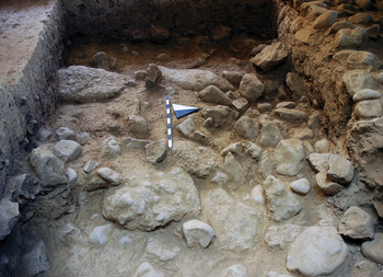
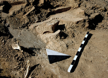
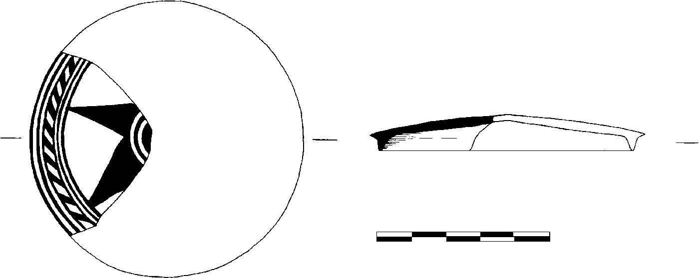
Under the grey layer, the yellow layer of sandy earth with stones and fewer finds was excavated. A skyphos with early Thapsos decoration (Aegion Archaeological Museum [ΑΜΑ] 2306) was found a short distance south of the altar, placed between stones (Fig. 30). Many sherds recovered from the yellow layer join vessels from the overlying grey layer, demonstrating that the two layers were deposited contemporaneously as fill for the construction of the apsidal temple. The yellow layer is 0.34/0.4 m thick in the south part towards wall 1, and decreases to 0.14/0.08 m towards wall 2. In the lowest part of the yellow layer were numerous unworked stones, large and small. In particular, several large stones found along the east flank of squares Α2–Γ2 were initially thought to be remnants of a makeshift enclosure of the altar, but the removal of the largest, northernmost one showed that they had simply fallen into the yellow earth (Kolia and Gadolou Reference Kolia and Gadolou2011). Beneath this particular stone were found parts of the terracotta architectural model with figurative decoration (ΑΜΑ 2018, 2170, 2313) published by Anastasia Gadolou in this volume (see also Kolia and Gadolou Reference Kolia and Gadolou2011, figs. 16–17) (Fig. 47). At a depth of –3.8/–3.9 m, particularly in squares Γ2 and Γ3, the earth is replaced by the dense layer of stones on which wall 2 is bedded (Fig. 31). To the south, towards wall 1, the quantity of stones is somewhat reduced. The earth between the stones is yellow, mixed in places with grey-black, and contains extremely few sherds (mainly of cooking vessels) plus lumps of burnt clay and a few animal bones. In square Γ2 at a depth of –4 to –4.1 m was a layer of river gravel containing no finds. River gravel is encountered even higher, at –3.74 m, in the east part of square Β2, while in squares Β1 and Γ1 it occurs at a depth of –3.63 m. Consequently, we observe that towards the centre of the temple the river gravel is found at greater depth, while as we proceed eastwards the archaeological layers peter out as the river gravel is at a higher level.
Skyphos ΑΜΑ 2306.

Layer of stones in square Γ3.

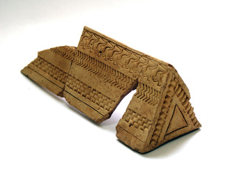
In the southeast part of the temple (squares Α1, Α2, Β1 and Γ1) a dark brown layer with traces of burning and plentiful pottery was identified at a depth of –3.4 to –3.8 m. This layer also extends beneath the foundation of wall 1 in these squares. River gravel was found beneath it. Several sherds recovered from this layer belong together with sherds from the grey layer: the two layers are thus of similar composition but the brown has fewer traces of burning. Pottery from the dark brown layer includes Middle and Late Geometric sherds, plus a few Early Geometric and several Protogeometric. Noteworthy among the finds is part of the roof of an architectural model with impressed decoration (ΑΜΑ 2125) which joins a fragment found in the grey layer in square Β3 (Kolia and Gadolou Reference Kolia and Gadolou2007, figs. 3–4; 2011, 155) (Fig. 32).
Roof with impressed decoration, of a terracotta architectural model ΑΜΑ 2125.

A Protogeometric building or construction at the east end of the temple, near the entrance, may have been destroyed when the site was levelled for the construction of the temple. Its existence would explain the large quantity of Protogeometric pottery found here. In the east part of the baulk between squares Β0 and Β1 a small part of a floor of hard, brownish red clayey earth (0.2 to 0.67 m wide, 0.9 m long) was identified at a depth of –3.41 m (Fig. 33). Conspicuous traces of burning and one broken Protogeometric kantharos (ΑΜΑ 2135) (Fig. 34) were found on this floor, plus a bronze hair ring at the edge of it.
Floor of the Protogeometric period in the baulk of squares Β1–Β0.

Kantharos ΑΜΑ 2135.

CHRONOLOGY
The ochre-yellowish argillaceous layer above the floor of the apsidal temple contained a very few sherds of the Late Geometric period and the seventh century bc. Of particular value in dating the use of the building to the first quarter of the seventh century bc is the group 97/2004, found on the floor in squares Α1–Α2, which includes a few Early Protocorinthian sherds (ΑΜΑ 1893–ΑΜΑ 1895) (Figs. 35–6). It is possible that the building fell into disuse in the second half of the seventh century, since very few Protocorinthian sherds of the first half of the seventh century can be distinguished among the sherds from the fill covering it (Fig. 37). The abandonment of the apsidal temple and its replacement with a new temple is indicated by the architectural members found in the layer with the roof tiles north of the Geometric building (see below).
Aryballos sherd ΑΜΑ 1893.

Sherd ΑΜΑ 1894.

Lid sherd ΑΜΑ 2163.
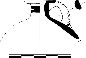
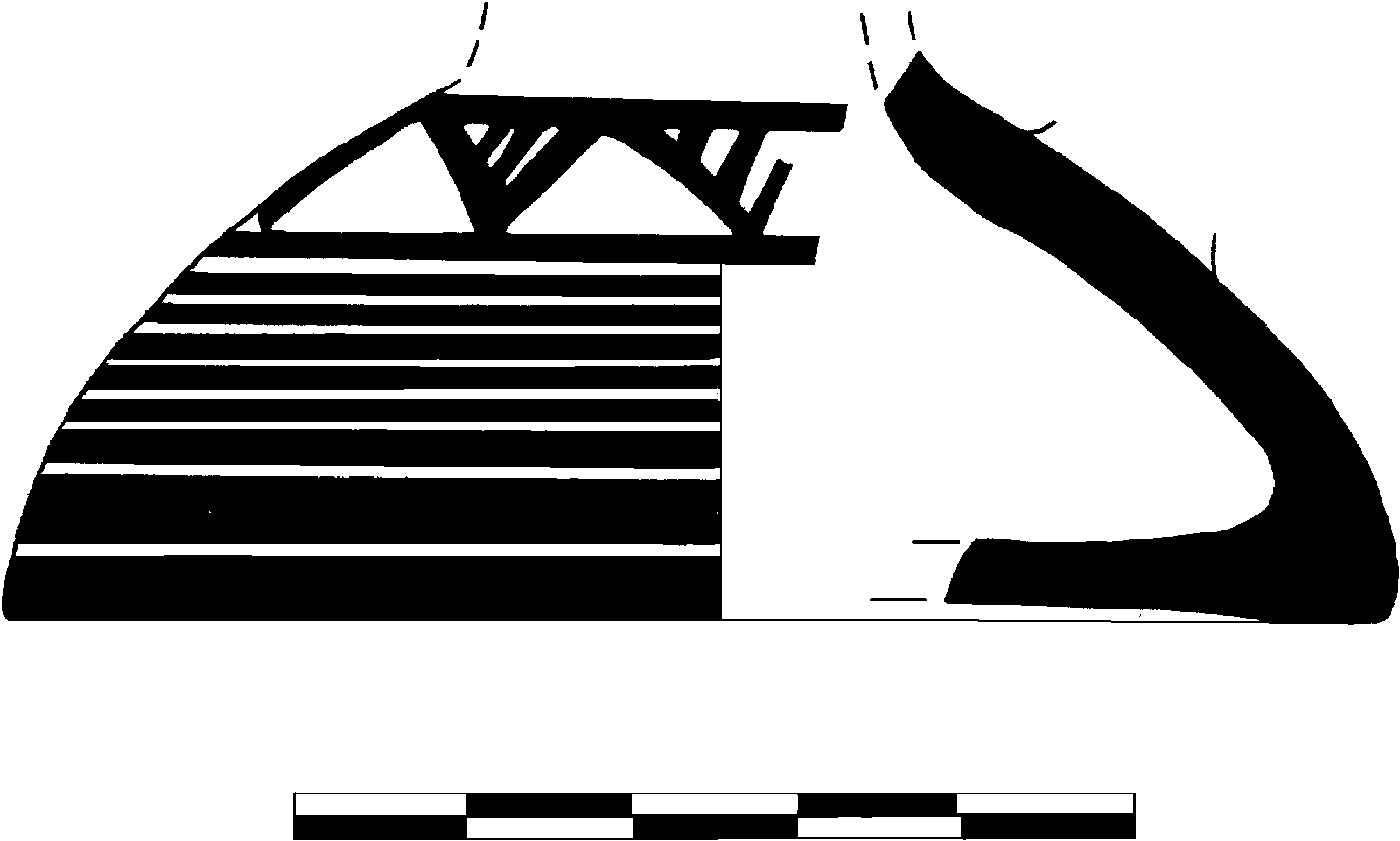
The dating of the temple construction to the very end of the eighth century bc is based on the decorated Late Geometric pottery found in all layers under the temple floor, and mainly on the Thapsos-type sherds (a class which ceased to be produced around 700 bc).Footnote 5 This date is confirmed by a fragmentary late eighth-century conical oinochoe (ΑΜΑ 2181), which is either Protocorinthian or an Achaean imitation, recovered from the pale yellow layer in squares Α1–Α2 (Dunbabin Reference Dunbabin1962, 36, no. 206, pl. 9) (Fig. 38).
Conical oinochoe ΑΜΑ 2181.
It emerges from the stratigraphy and the pottery that, despite their different constitution, the successive layers below the temple floor down to the altar floor were deposited contemporaneously during the construction of the building in order to fill in the altar and raise the ground level. This is corroborated by the fact that joining or associated sherds from numerous vases, as well as parts of the architectural models, were found dispersed into different layers. A case in point is the roof of the terracotta architectural model (ΑΜΑ 2018, 2170, 2313), parts of which were found mainly in the grey layer east and northeast of the altar, in squares Β3, Γ2, Γ3 and Γ4, as well as in the overlying yellowish brown layer near the foundation of the first column base, although one other fragment was found in the lower yellow layer at a depth of –4.13/–4.18 m, below the large stone northeast of the altar.
The temple construction should be dated on the basis of the latest sherds, i.e. the Late Geometric pottery, even though all layers also contain earlier finds. Indeed, Late Geometric pottery is predominant in all layers (Figs. 24–5, 27, 38), although in the grey and the lower yellow layer Middle Geometric pottery constituted over 30% of the total of decorated sherds (Figs. 23, 30), and all layers contained a small number of Protogeometric and Early Geometric sherds.
The grey layer contains finds related to rites performed at the altar, including animal bones obviously from sacrifices, and cooking pot sherds among other finds (Figs. 23–6, 28–9). The pottery shows that the altar was in use throughout the second half of the eighth century, until the construction of the temple at the end of the century, but the large percentage of Middle Geometric pottery strongly suggests that the altar was built in the first half of the eighth century. Important evidence for the date of the altar is provided by a skyphos with early Thapsos-type decoration (ΑΜΑ 2306) found in the yellow layer just south of the altar, placed between stones at a depth of –4.01 to –4.07 m, i.e. slightly higher than the altar floor (Fig. 30). This skyphos dates from c.760/750 bc, offering a valuable datum for the use of the altar in the second quarter of the eighth century bc.Footnote 6
As noted, all layers contained Protogeometric sherds, but these are most frequent in the dark brown layer in the southeast part of the temple, where they may be associated with a destroyed building or other construction, as the remnant of floor at the east end of the temple indicates. The best surviving specimen is the kantharos ΑΜΑ 2135, which was found in fragments on this floor (Fig. 34). It is similar to the kantharos from a funerary pithos found at Derveni, some 5 km southeast of Nikoleika (Dekoulakou Reference Dekoulakou1982, 219–36; Gadolou Reference Gadolou2008, 35, 153, pl. 135 α). The floor with the traces of burning on the north flank of the altar yielded only a few undiagnostic sherds; nonetheless, it must predate the construction of the altar (perhaps thus dating to the late ninth–early eighth century bc).
TRENCHES OUTSIDE THE TEMPLE
Trench Δ 2
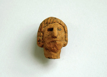
Δ2, the only trench outside the north wall of the temple, revealed grey-brown soil with gravel on the surface. Beneath that, river gravel was identified at a depth of –3.71 m along its south and east flank: this is in circular formation to north and west, while in the rest of the trench the soil is grey in colour, identical to the corresponding layer inside the temple (Fig. 39). At a depth of –3.8 m in the northwest corner of the trench lay a pyre defined by a surround of unworked stones. The sherds from the pyre and from the grey earth date to the Late Geometric period, while notable among the finds is the head of a terracotta male figurine ΑΜΑ 2840 (Fig. 40).
View of square Δ2 from the southeast. Visible in the northwest corner is the fire.

Figurine head ΑΜΑ 2840.

Trenches north of the temple
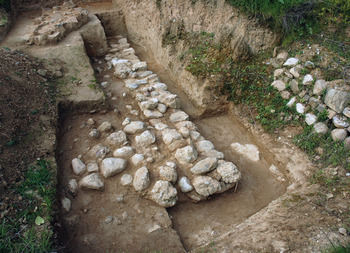
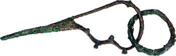
A trench oriented east–west (12.7 × 5.6 m) was opened 20 m from the north wall of the temple. In the west part, at a depth of –5.25 m and oriented north–south, a wall of small and medium unworked stones stood 0.37 m high, 4.53 m long and 0.6 m wide. It continued to the south beyond the trench, but to the north was destroyed (Fig. 41). East of it was a layer of fallen stones, from which was retrieved a late eighth-century bronze Drachenfibel or Dragofibel fibula (Sundwall Reference Sundwall1943, 248, fig. 409, type HIIIa c1; Laux Reference Laux1973, 50–1, no. 234, pl. 47). This type was widespread in North Italy, mainly in the seventh and sixth centuries bc, and its discovery hints at the area's relations with the Italian peninsula (Fig. 42).
The wall of the Geometric period in the trench north of the temple.

Bronze fibula ΑΜΑ 954.

East of the wall and at a higher level (–4.3 to –4.88 m), in the yellowish sandy soil, was a dense layer of roof tiles and other terracotta architectural revetments – simas with painted decoration, palmette tiles with relief decoration (Fig. 43), and parts of terracotta plaques with fragmentarily preserved relief figures, outstanding among which is the head of a sphinx. A few fragments of sandstone Doric column drums were also unearthed. The tiles comprise over 1200 fragments of tegulae and imbrices, mainly of Corinthian type. All these finds date to around the mid-sixth century bc, indicating an Archaic successor to the Geometric temple.
Palmette roof tile from the layer with the roof tiles, north of the temple.

A skyphos found in fragments in the southwest part of the layer, close to the relief head, plus sherds of a second of the same type found beside it, provide important dating evidence for the creation of the deposit and thus the destruction of the temple to which the tiles and architectural terracottas belonged (Fig. 44). Exact parallels for both vases (Sparkes and Talcott Reference Sparkes and Talcott1970, 260, nos. 349–50, pl. 16, fig. 4; Robinson Reference Robinson1950, 308–9, nos. 575–9, pls. 197, 201) date the deposit to the transition to the second quarter of the fourth century bc, the time of the destruction of Helike in the earthquake of 373/372 bc. It is thus possible that the Archaic temple was destroyed in this earthquake: the remains of its superstructure were then disposed of, presumably very close to its ruins, which should be sought in the Komninos–Karachaliou building plot.
Skyphos ΑΜΑ 2888.

Trenches east of the temple
In 2008 two trial trenches were opened east of the temple. The first, 12 m from the temple and approximately on its axis, revealed a conspicuous layer of burning with Late Geometric sherds, stone chippings, and a bronze pin at –1.8 m below the surface. On the instructions of the landowner the trench was back-filled with no further excavation, but the burnt material in the earth and its position east of the temple entrance suggest that it probably relates to the altar of the apsidal temple.
A second trench further north brought to light at a depth of –0.80 m the upper part of a wall which may belong to an apsidal building oriented north–south, as it forms a slight but clear northwards curve. Built of flat stones in two courses, it rests in a brownish yellow layer with a very few and undiagnostic sherds.
THE APSIDAL TEMPLE
The Geometric temple at Nikoleika is apsidal and 7 m wide. While its overall length is as yet unknown (Fig. 45), the slight convexity of the south wall and the more pronounced of the north leads to the hypothesis that it is no more than 20 m long. If so, it contrasts with the apsidal hekatompedoi of the second half of the eighth century bc, such as the temple of Artemis Aontia at neighbouring Ano Mazaraki (Petropoulos Reference Petropoulos1987–8, 81–96; Reference Petropoulos1992–3, 141–58; 1997, 165–92; Reference Petropoulos and Greco2002, 143–65) or the temple of Apollo at Eretria (Building D) (Auberson and Schefold Reference Auberson and Schefold1972, 116–18; Coldstream Reference Coldstream1977, 196, fig. 104; Bérard Reference Bérard1982, 91; Mazarakis-Ainian Reference Mazarakis-Ainian1997, 62 and n. 175 with bibliography, fig. 105).
Ground plan of the temple.

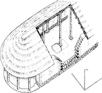
The particularly neat masonry of the arc-shaped end of the south wall and the regularity of its curve are impressive (Figs. 9, 10). Initially this wall was considered to be a remnant of the apse, but the distinct function of the arc in relation to the long walls of the temple is reinforced by their different construction, as noted above. Consequently, it can only be the south part of the stylobate of a semicircular prostoon, analogous to that of the temple of Artemis Aontia at Ano Mazaraki, although there the support comprises five independent stone bases and not a single stylobate (Petropoulos Reference Petropoulos1997, 166–7, drawings 1–2; Reference Petropoulos and Greco2002, 150). The addition of the semicircular prostoon will have given the façade of both temples a monumental aspect. It is, however, suggested that the roof of the prostoon should not be restored as a sloping or flat semicircular shelter in front of the temple façade with the open triangular tympanum, but as integral to the roof of the temple proper. In this case, the roof above the prostoon would have been half-conical, as in the buildings of oval ground plan (Fig. 46). This solution is preferred also by the excavator of the Ano Mazaraki temple, Michalis Petropoulos, although he proposes three alternative hypotheses for the restoration of the roofing (Petropoulos Reference Petropoulos1997, 167; Reference Petropoulos and Greco2002, 154, fig. 10). The single roof of the semicircular prostoon and the main building would give the temple the appearance of an oval building, even though it is apsidal in ground plan. Furthermore, the prostoon would have had the character of a pronaos or prodomos, as at Ano Mazaraki (Petropoulos Reference Petropoulos1997, 169; Reference Petropoulos and Greco2002, 155). Consequently, we may suppose that, by analogy with the temple of Artemis, an adyton perhaps existed in the west, unexcavated, part of the temple at Nikoleika. With regard to the single stone stylobate, it seems that the use of stone architectural members became common in temple building of the late eighth–early seventh century bc. In Corinth in particular, limestone blocks or other stone members were frequently used as bases for wooden uprights in buildings of rubble masonry or with mudbrick superstructure, since their surface was flat and smooth, but also because they protected the wood from damp (Rhodes Reference Rhodes1987, 478). Taking these factors into consideration, the semicircular prostoon at a temple entrance appears to be an innovation distinctive to the Late Geometric temple building of Achaea and is consistent with attempts to monumentalise cult buildings in this period. Nonetheless, this solution seems to have held limited appeal, since it is not encountered outside eastern Achaea.
Reconstruction drawing of the temple (axonometric).

The roof of the temple must have been made of reeds and straw with clay, while the frame will have been timber, as was usual in this period (Fagerström Reference Fagerström1988, 101–2). Moreover, the temple excavation yielded no evidence of tiles, with the exception of two fragments found on the surface which must come from another building. In the reconstruction drawing of the temple (Fig. 46), the roof is depicted as pitched, not vaulted, following the roofs of the two terracotta architectural models with impressed and figurative decoration (Figs. 32, 47; and Gadolou this volume, figs. 1–6). At its east and west ends it is restored as half-conical, while it is not known whether there was an internal ceiling structure.
Representation of a chariot race on the architectural model ΑΜΑ 2018, 2170, 2313.

The thickness of the foundations indicates that the temple superstructure was of mudbrick, although no clear traces of this have been found in the surface layer. Along the inner flank, the four square sandstone bases at intervals of 1.8 to 2 m, roughly corresponding to the bases of the central colonnade, must have been used for bedding vertical wooden supports to strengthen the temple walls and support the timber frame of the roof. Corresponding bases will have existed along the north wall of the building. Similar internal buttressing is encountered in the south temple at Kalapodi (late eighth–early seventh century bc), the temple of Apollo at Halieis (Late Geometric–Early Archaic) and the first temple of Artemis Orthia in Sparta (c.700 bc).Footnote 7 In these temples, however, the vertical wooden piers were set partially in the mudbrick walls, i.e. they functioned as engaged pillars (Mazarakis-Ainian Reference Mazarakis-Ainian1985, 43). This was evidently not so at Nikoleika, because the surface of the stone foundation of the south wall is situated higher than the surface of the bases.
The temple at Nikoleika had a central colonnade which supported its pitched roof. The central colonnade is encountered in apsidal buildings from as early as the Protogeometric period (e.g. in the Heroon at Lefkandi), but is established in rectangular or apsidal buildings of religious or cult function from the mid-eighth century bc (see e.g. the Heraion of Samos, the temple of Apollo in Eretria, or the temple of Artemis Orthia in Sparta) (Fagerström Reference Fagerström1988, 107–8). However, in the larger temple of Artemis Aontia at Ano Mazaraki, the internal width of which is 5.9 m, there was no internal colonnade (at Nikoleika the internal width is 5.3 m). Moreover, the temple of Artemis Aontia had a peristasis, whereas there was no such feature at Nikoleika (perhaps because in this lowland coastal area it was not needed to protect the building from the weather, unlike at mountainous Ano Mazaraki). At Ano Mazaraki, the bases of the peristasis are divided into two groups, according to material. The limestone bases belong to the first phase of the temple and the sandstone to the second, when the temple was enlarged and acquired the semicircular prostasis (Petropoulos Reference Petropoulos1992–3, 146–9; 1997, 168–9).
In short, the temple at Nikoleika is an apsidal building in which the principal characteristics of late eighth-century bc architecture are present, with the exception of the semicircular prostoon which, as we have seen, is a peculiarity of Achaean temple building in the Late Geometric period. It is generally accepted that there was a significant upsurge in temple building in the second half of the eighth century bc, with a proliferation of constructions associated with worship. A variety of arguments have been made to link this phenomenon with major social processes, especially surrounding the creation of the city-state (Mazarakis-Ainian Reference Mazarakis-Ainian1985, 46–7; Reference Mazarakis-Ainian, Hägg, Marinatos and Nordquist1988, 118–19), and it is in this historical framework that the temple at Nikoleika is set. The monument was probably erected by the aristocracy of Helike to house cult activity that until then had taken place exclusively at the open-air altar.
THE ALTAR
The quadrilateral construction approximately in the centre of the later apsidal temple is identified as an altar on the basis of its physical form, the composition of the grey layer with strong traces of burning, and the type and quantity of finds (animal bones, broken vases, figurines, numerous terracotta wheels, fragmentary architectural models and metal artefacts, and mainly bronze pins and rings).
Rupp classifies brick-built altars of rectangular ground plan in type B of his first category of altars (rudimentary altars), while ash altars are classed as type A (Rupp Reference Rupp1974, 284). In a more recent study by the same researcher, brick-built altars are classed as type D of rudimentary altars, noting the addition of types B (natural rocks), C (piles of stones) and E (small terracotta altars) to the scheme (Rupp Reference Rupp, Etienne and Le Dinahet1991, 304). Following Yavis' typology the Nikoleika altar could be classed in the category of earthen mounds, rude stones and stone heaps used as altars (Yavis Reference Yavis1949, 214–15). And according to Riemer's scheme it can be included, on the criterion of its shape and not its construction material, in the category of early stone altars in the form of a table (trapeza) or rectangular flat surface (Block- oder Tischaltäre) (Riemer Reference Riemer2005, 185–7, figs. 72,1 and 75; Sahin Reference Sahin1972, 36–40). These date to the Protogeometric (Altar I in the Samian Heraion is dated to the tenth century bc, although this could be lowered slightly) (Riemer Reference Riemer2005, 186 with n. 416) and mainly the Geometric period. According to Riemer, altars upon which the sacrificial fire was lit and the ash remained after the ritual was over can be classed among ash altars in a wider sense of the term (Riemer Reference Riemer2005, 179–80).
From the Geometric period the commonest material indications of the performance of animal sacrifice in sanctuaries are layers containing ash, bones and votive offerings, whereas architectural remains of altars are rare (Sahin Reference Sahin1972, 16; Rupp Reference Rupp1974, 281–4; 1983, 101). On present evidence, as Riemer observes, the typological and chronological development of altars during the Geometric period cannot be clearly distinguished (Riemer Reference Riemer2005, 179–80, 185–6). No other Geometric brick altar has yet been found. In 1969 a Classical mudbrick altar coated with whitish green clay (dated 475/450–375/350 bc) was excavated in the temenos of the Sacred Spring in Corinth (Williams Reference Williams1970, 23–4, pl. 11; Rupp Reference Rupp1974, 284). Four phases are observed, and it seems that the altar was reconstructed three times because of its easily eroded material. Initially it was constructed of mud with a coating of whitish green clay, while in the succeeding phases it was of mudbrick outside and mud inside, again coated with whitish green clay. The earliest altar was just 0.16 m high and 0.97 m wide, while the width of the later altars ranged from 0.84 to 0.88 m, their length was 8.75 m and the height of the last altar is 0.21 m. Broken bones found around the altar are mostly of pigs and bovines, but also of sheep and goats. In the excavator's view, the sacrificed animals were burnt in small pieces in a zone 0.5 m wide along the west flank of the altar. Chronologically closest to the Nikoleika altar is the first altar of the temple of Artemis Orthia in Sparta, dated by Rupp to the late eighth century bc (Boardman Reference Boardman1963, 1–7; Rupp Reference Rupp and Hägg1983, 104), which consists of an oblong stone foundation which is conjectured to have supported a mudbrick superstructure. In the second half of the eighth century, plain rectangular altars of unworked stones outside and earth inside, a type already known in the earliest altars Ι and ΙΙ in the Samian Heraion, reappear (Rupp Reference Rupp and Hägg1983, 104). According to Rupp, altars of this type may have had mudbrick superstructures. A similar construction to that of the altar at Nikoleika is also observed in the rectangular mudbrick eschara inside the Late Geometric Sacred House at Plato's Academy in Athens (Mazarakis-Ainian Reference Mazarakis-Ainian1997, 141–2, fig. 132). The existence of mudbrick altars is also known from textual sources. For example, Pausanias (6.20.11) refers to the mudbrick altar at the starting line of the hippodrome of Olympia, which was rebuilt each year because of erosion due to weather conditions (Rupp Reference Rupp1974, 284).
The altar at Nikoleika, with its alternating layers of reddish brown mudbrick and thinner layers of yellow soil, shows a pattern of colours reminiscent of the mudbrick walls of the Early Archaic south temple at Kalapodi (Felsch Reference Felsch1987, 15, fig. 22; Reference Felsch, Etienne and Le Dinahet1991, pl. XIII b; Mazarakis-Ainian Reference Mazarakis-Ainian1997, 138). Mudbrick construction obviously favoured the development of high temperatures during the burning of the sacrificed animals. It was easy to remove the burnt upper layers and replace them after the rituals or when they were damaged by the elements. This is demonstrated by the discovery of burnt pieces of mudbrick and clay in the grey layer, as well as in the lowest yellow layer among the fallen stones (Fig. 48). Pieces of clay were also found around the altar of Artemis in the sanctuary of Apollo Daphnephoros in Eretria, where they are thought to come from the cleaning and replacement, after every ritual, of the clay slab covering the stone altar (Huber Reference Huber2003, 112–14).
Parts of burnt mudbricks in the grey layer in square Β4.

So far no traces of burning have been found on the altar at Nikoleika or in the upper mudbrick layers. After the final ritual the altar must have been cleaned and its upper layers replaced, after which it was covered by two layers of clay and the space around it filled in order to build the temple.Footnote 8 By contrast, at Kalapodi, after the last sacrifice before the foundation of the Classical north temple, the ash and the remains of the sacrifice were left in situ on the altar, as were the votive offerings (Felsch, Kienast and Schuler Reference Felsch, Kienast and Schuler1980, 89 [R.C.S. Felsch]; Reference Felsch, Etienne and Le Dinahet1991, 88–91). And at Kommos on Crete, a terracotta bull figurine with strong traces of burning from the sacrificial fire was found on the Hellenistic altar C (Shaw and Shaw Reference Shaw and Shaw2000, 691). It is notable that the floor of the temple at Nikoleika is markedly elevated exactly above the east part of the altar, a kind of marker (sema) of the position of this locus sanctus. Cult was therefore continued at the same point but in a new form, reflecting the socio-political developments that led to the foundation of the temple in the late eighth century bc, when in all probability the altar was transferred to a new position east of the temple.Footnote 9
A black layer similar in composition to the grey layer at Nikoleika was found in the temple of Artemis Aontia at Ano Mazaraki. It contained ash, rubble and votive offerings – in the excavator's opinion the remains of an ash altar that predates the temple (Petropoulos Reference Petropoulos1992–3, 153, 156). However, the ash layer was identified in trench V, at the north end of the temple, south of the north end of the long west wall (wall 1) which must belong to a later extension of the building (Petropoulos Reference Petropoulos1997, 168–9, drawing 1). The ash altar may therefore relate to the first phase of the temple, since it is located in front of the temple entrance, rather than being an earlier structure for open-air worship as at Nikoleika.
The contents of the grey earth, which include pottery and other votive offerings from the Protogeometric period to the end of the eighth century, attest to the longevity of worship. The finds are mixed with the earth, burnt material, bones and, at some points, with small unworked stones. It is impossible to detect any stratigraphy, which is also the case at other long-lived sanctuaries with layers from sacrifices. Characteristic examples are the layers in the Pelopion at Olympia and the east terraces at the sanctuary of Poseidon at Isthmia (Kyrieleis Reference Kyrieleis2006, 35–47; Morgan Reference Morgan1999, 316). Since the finds from the grey layer originate from the rituals on the altar, the earliest pottery dates the beginning of cult to the Protogeometric period (950–850 bc). The discovery of the earlier fire-hardened clay floor with ash on it, which continues southwards under the altar, suggests that in a previous phase a clay hearth with an ash altar, from which the earliest pottery in the grey layer perhaps derives, existed on the site of the later brick-built altar.
Some conclusions can be drawn about the ritual performances by examining the composition of the grey layer. This does not consist exclusively of burnt remains but also has quite a lot of soil, which explains the colour variation from grey-black to grey-brown or dark brown. Consequently, it lacks the greasy texture and black colour encountered in analogous layers in sanctuaries where the remnants of the sacrificial fire were deposited around the altar and levelled from time to time (Kyrieleis Reference Kyrieleis2006, 35–47; Huber Reference Huber2003, 114; Papapostolou Reference Papapostolou2008, 191; Felsch Reference Felsch2007, 9; Shaw and Shaw Reference Shaw and Shaw2000, 670–3; Rupp Reference Rupp and Hägg1983, 101–2; Lebesi Reference Lebesi1985, 19). Thus, for example, the greasy consistency of the black layer at Thermon is attributed to the burning of fat from the sacrificial animals, organic materials, and perhaps animal blood (Papapostolou Reference Papapostolou2008, 209–11). Instead, the composition of the burnt layer at Nikoleika is similar to that in the east part of the sanctuary of Poseidon at Isthmia, where the remains of fires with bones and pottery of the Protogeometric and Geometric period are in secondary deposition at the very least, since after each ritual the remains of the sacrifices and sacred meals were removed from the hearth (ash altar) and not left to accumulate around it. This layer was used as filling on the east terraces of the temple in a series of operations to extend the usable space as later monumental constructions were built (Morgan Reference Morgan1999, 319). At Nikoleika too, the remains of each sacrifice and the associated meals must have been cleared away from the area around the altar and dumped perhaps nearby, as also at Kalapodi, where a rectangular precinct of the seventh century bc served as a deposit (apothetes) for the ash from the sacrifices (Felsch Reference Felsch2007, 11). At Nikoleika this deposit was laid in the late eighth century over the entire site of the temple and the area to the north in order to raise the ground level and preserve the altar prior to the erection of the apsidal building.
Animal bones were found mainly in the grey layer, broken into tiny pieces 1–2 cm in size.Footnote 10 Some 80% are carbonised and calcified, while the rest are not burnt. On 26% intense surface erosion indicates that they remained exposed on the ground for many years after the rituals, while some have butchery marks. The few diagnostic remains are mainly from domesticated animals, predominantly sheep, perhaps goats, and to a lesser extent pigs and a few bovines, while two examples of deer have been identified.
Study of the osteological material has revealed that during this period sacrifices were made in which parts of the animals were charred completely for the deity honoured. These sacrifices were followed by ritual meals in which worshippers participated, as attested by bones without traces of burning, from the cooked parts of the animals. The burnt bones show a preponderance of long bones, indicating the performance of regular sacrifices in which the thigh or thighs of the animal were burnt completely on the altar. While it is premature to draw conclusions given the relatively small quantity of diagnostic osteological material, the possibility that holocaust sacrifices took place, as at Thermon, cannot be ruled out (Papapostolou Reference Papapostolou2008, 200–2). Research in recent years has shown that holocaust sacrifices were not associated exclusively with the cult of chthonic deities but were special rites performed in response to emergency events (Ekroth Reference Ekroth2002, 226–8, 307). It should be noted too that in holocaust sacrifices the slaughtered animal was rarely burnt whole: more often, just pieces were burnt. The quantity of meat incinerated in these rites was related to the seriousness of the situation or the danger threatening the community (Ekroth Reference Ekroth2002, 217–28).
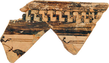
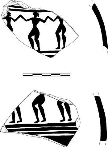
The conclusion that meals were consumed is strengthened by the pottery in the grey layer, a large percentage of which consists of drinking vases (mostly skyphoi and kantharoi) and kitchenware (mostly cooking pots and plates) (Figs. 23, 26). A small number of jugs and oinochoai, amphoriskoi and two-handled or three-handled plates were also found (Figs. 24–25). The meat from the sacrificed animals used for the sacred meals must have been cooked near the altar. The fire in square Δ2, north of the apsidal temple, was perhaps associated with the preparation of meals, bearing in mind the similar secondary fires in spaces K2 and K3 at Minoa on Amorgos (Marangou Reference Marangou and Hägg1999, 19–20). However, the meals will have been consumed around the altar. Ritual meals in the open space around the altar were held in the Samian Heraion, as well as in the sanctuary of Poseidon at Isthmia (Kron Reference Kron1988; Morgan Reference Morgan1999, 319–20). The ceremonial possibly also included libations on the altar, for which plates, oinochoai and jugs would have been used. The ritual may have involved dance too, as is suggested by the sherds from the oinochoe or jug with a scene of a representation of a dance of male figures (Fig. 49).Footnote 11
Jug sherds ΑΜΑ 1988, 2304.

The pottery from the grey layer consists of a large number of sherds with little erosion of the edges, which in many cases can be joined. This may indicate that at Nikoleika the sacrifices were followed by a smashing of the vessels used in the ritual and the devotees' meal (Morgan Reference Morgan1999, 323; Shaw and Shaw Reference Shaw and Shaw2000, 692; Simantoni-Bournia Reference Simantoni-Bournia2000, 213; Huber Reference Huber2003, 146–7). Moreover, the sherds (cooking vessels excluded), the wheels and the horse figurines display no traces of burning, indicating that the vessels and votive offerings were not placed near the sacrificial pyre during the ritual (Kyrieleis Reference Kyrieleis2006, 45–6).
Overall, however, it should be emphasised that on present evidence any reconstruction of the ancient rituals is purely hypothetical. In this early period ceremonial had not been crystallised: indeed, in the Geometric period considerable diversity is encountered in cult customs, related to local traditions as well as to the deity worshipped in each sanctuary.
EPILOGUE
The numerous terracotta chariot wheels, the horse figurines, the painted representation of a chariot race on the roof of the terracotta architectural model (discussed by Anastasia Gadolou in this volume; Fig. 47), as well as other depictions of horses or individual wheels, support the hypothesis that the deity worshipped was associated with horses and chariot races, perhaps Poseidon (Wüst Reference Wüst1953, lines 470–2; Schachermeyr Reference Schachermeyr1950; Burkert Reference Burkert1977, 217–18; Langdon Reference Langdon1989, 198–201; Mylonopoulos Reference Mylonopoulos2003, 365–8, 398).
The ancient cult of Poseidon Heliconius at Helike is attested in the sources. Homer first mentions the worship of the god at Helike (Iliad 8.203, 20.404), and Pausanias (7.24.5) recounts that when the first inhabitants of Helike, the Ionians, were expelled by the Achaeans they took their cult to their new homeland in Asia Minor. Moreover, several ancient authors explain the destruction of Helike by the earthquake of 373/372 bc in terms of the wrath of Poseidon at the disrespect shown by the city's residents to the emissaries of the Ionian cities of Asia Minor, who were seeking the ancient statue of the god, or at least an example of its type, in order to make one like it for themselves (Aelian De Natura Animalium 11, 19; Diodorus Siculus 15.48.3–49.5; Pausanias 7.24.5–6; Polyaenus 8.46; Strabo 8.7.2). According to some researchers, Poseidon Heliconius was worshipped in a sacred grove without a temple. This view is based on ancient sources, although mostly those much later than the destruction of Helike and the sanctuary of Poseidon by the earthquake of 373/372 bc.Footnote 12
The relation of the deity worshipped to horses and chariot races is underlined by the finds from the grey layer, which, as we have seen, contained votive offerings and vessels used in the sacrifices. Noteworthy is the discovery in this layer of 60 wheels from chariot models; one should also note the terracotta horse figurines with holes in the shoulders for attachment to model chariots (Morgan Reference Morgan1999, F34–F35, pl. 74; Heilmeyer Reference Heilmeyer1972, 118–22, pl. 21; Sinn Reference Sinn1981, 68, nos. 51–9, pls. 10.6, 9–11; Stampolidis Reference Stampolidis2004, 273, no. 338; Popham and Lemos Reference Popham and Lemos1996, pl. 55, nos. 11–13, pl. 58, nos. 1, 5–7, 19, pl. 60, no. 23, pl. 126 a; Shaw and Shaw Reference Shaw and Shaw2000, 179–81, nos. AB19–AB31, pls. 3.10, 3.11, 3.22, 3.39; Foxhall Reference Foxhall and Hattler2008, 116, nos. 42, 43) (Table 1, Figs. 22, 28–9). However, several wheels must have been deposited as singletons, since only eight horse figurines were found (Eder and Wagner Reference Eder, Wagner and Hattler2008, 203, no. 107). The large number of wheels recovered from this layer indicates that these objects were related directly to the deity worshipped, since they are the most numerous and characteristic find. The direct relationship between the worship of Poseidon and the representation of a chariot race on a terracotta architectural model from Nikoleika (Fig. 47) is discussed in detail by Anastasia Gadolou in this volume. Indeed, the terracotta architectural model is a very special votive offering which was dedicated to the god and then smashed after the ritual, just as the vases noted above (Huber Reference Huber2003, 146; Simantoni-Bournia Reference Simantoni-Bournia2000, 213). Poseidon's relation to horses and chariots is known already from the Mycenaean period, as attested at the Late Helladic IIIA–IIIB sanctuary at Methana attributed to Poseidon. Among the votives offered there were horse figurines with helmeted riders and chariot models (Konsolaki Reference Konsolaki and Hägg2002, 33, 35–6). Moreover, the festivals in honour of the god held in most of his sanctuaries in the Peloponnese included chariot races (Mylonopoulos Reference Mylonopoulos2003, 316).
Finally, the dedication of the architectural models found in the grey layer (parts of at least three have been recovered and there might have been more) may relate to Poseidon's most ancient capacity as god of earthquakes and natural phenomena (Burkert Reference Burkert1977, 217; Mylonopoulos Reference Mylonopoulos2003, 391–5). Epithets related to Poseidon's status as god of earthquakes include ἐνοσίχθων, ἐννοσίγαιος, ἀσ φάλειος, γαίοχος, σεισίχθων. The dedication of architectural models, generally associated by scholars with the worship of Hera (Fagerström Reference Fagerström1988, 155–7), could be an act to placate Poseidon and solicit his protection for the dedicators, their houses and the community in general in an area particularly prone to seismic activity.
Continuing excavation will give a fuller picture of the sanctuary, which occupied a sizeable area around the apsidal temple. The discovery of the temple of the sixth century bc is awaited, and it will be a priority to complete the excavation of the apsidal temple and to excavate the Geometric building north of the temple. Nonetheless, the evidence currently available demonstrates that the Nikoleika shrine was a major sanctuary of Helike, with cult practised continuously from Protogeometric into Classical times, when the Archaic temple must have been destroyed by the earthquake of 373/372 bc. Its particular significance lies in the fact that essentially all stages in the development of an age-old and initially open-air cult area are preserved in a temple of the eighth century bc. And for the first time a building – indeed a temple – of ancient Helike has been identified and excavated.
APPENDIX: THE FAUNAL REMAINS FROM THE GEOMETRIC SANCTUARY
by Eleni Psathi
Ephorate of Paleoanthropology and Speleology of Northern GreeceFootnote 1
Excavation of the sectors surrounding the sacrificial altar has yielded animal bone which belongs to a single stratigraphic unit. This unit is composed of several layers with distinctive sediment coloration. Pottery joins between these layers testify to their chronological homogeneity. The bone material contains both burnt and unburnt remains, but the great majority are charred and reduced to very small fragments. There is, therefore, strong evidence for the practice of animal sacrifice, sacred meals and burnt offerings at the altar, but probably a significant part of both the cultural and the organic material was not found in situ.
It is possible to define a part of the above stratigraphic unit as the level of fire sacrifices at the altar par excellence (henceforth called the ‘Altar unit’). This comprises the lower yellow, grey-brown, grey-yellow and dark brown layers, and contains all types of finds mentioned above. In this study the faunal material from this level is distinguished from that in the rest of the unit.
General presentation and quantification of the material
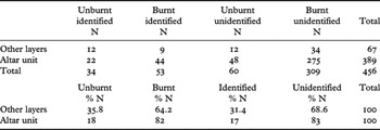
456 bone remains are recorded (Table A1), 81% of which are unidentified fragments 1–2 cm long. Similarly, 80% of the remains are burnt (90% of the burnt remains are in fact calcined). Taphonomic observations suggest that the high frequency of burning, the intense fragmentation and the small number of remains identified anatomically or to species level are closely related: bones already fragile or fragmented by fire are easily reduced to crumbs by trampling, sediment disturbances or bio-erosion. Indicative of the latter is the high number of remains displaying root etching and cortical exfoliations (26%), both of which indicate the prolonged exposure to atmospheric conditions natural in open-air cult places. The above pattern of bone preservation is very pronounced in the altar context, which has yielded the bulk of the bone material (85.3%), and justifies the separation of the ‘Altar unit’ from the rest of the material, where the low percentage of burnt remains is correlated with a higher frequency of identified items. However, even in the ‘Altar unit’ some unburnt material is present, suggesting the introduction of bone debris resulting from the butchery process or from the debris of cooked meat.
General quantification of animal bones remains from Nikoleika (N = Number of remains).

Animal species, meat processing and age of culling
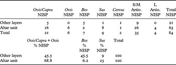
The faunal assemblage comprises the common domestic group (Table A2) : ovicaprids, cattle and pigs. Wild fauna are represented only by two cervid remains (probably red deer, Cervus elaphus) and do not appear meaningful in cult activities. Of the ovicaprids, only the genus Ovis (sheep) can safely be identified.
Frequency of mammal taxa (NISP = Number of identified specimens, S/M Artio. = Small/medium-sized unidentified Artiodactyla, L Artio. = Large-sized unidentified Artiodactyla).

According to the general frequency of each taxon, sheep and possibly goats clearly predominate,Footnote 2 especially if one also considers the category of small/medium-sized anatomically identified remains. However the presence of pigs and cattle is also important. It is interesting to note the sharp rise in the percentage of cattle, followed by a great reduction of pigs in the layers not associated directly with the altar. Is this a sample artefact, given the small number of remains in those layers and possible contaminations from the ‘Altar unit’, or does it reflect distinct cult practices affecting each animal species?
Skeletal preservation per species reveals major differences between the ovicaprids and the rest of the fauna present. Always taking into consideration the unidentified small/medium-sized artiodactyls, though with some degree of caution due to the small number of identifiable remains, it seems that entire carcasses of ovicaprids were treated in the vicinity of the altar, although some anatomical elements are completely or nearly absent, like small compact bones (e.g. carpals, tarsals), teeth and finally vertebrae. All the meat-bearing bones are present although in very small numbers, the central metapodials being more abundant (Mc and Mt III–IV), possibly because they are easily recognisable due to their morphology. In contrast, cattle and pigs are represented by few anatomical elements. The cattle profile is the opposite of that observed in sheep/goats, displaying essentially cranial and axial remains: pigs are identified by cranials and phalanges, and red deer by one metapodial fragment and one phalanx. Another interesting pattern emerges if only the ‘Altar unit’ is considered: sheep/goat and pig remains are burnt, while those of cattle and deer are not. Bearing in mind that most of the material is charred, the differential preservation observed in each species, as well as the anatomical discrepancies between the different species, can only be partially attributed to taphonomic factors like the inherent resistance of each category of bone and the destructive power of the fire, or recovery bias (all the sediments were systematically dry sieved). This pattern too is probably the result of culinary and/or sacrificial practices, such as meat preparation and consumption in different areas of the sanctuaryFootnote 3 and, possibly, the throwing of bone debris after meat consumption even onto the altar fire.
Even so, focusing again on the ‘Altar unit’, the high percentage of unidentified charred fragments (Table A1), which are nearly all mid-shafts of long bones and should be attributed to small/medium-sized animals, along with the equally high frequency of sheep/goats, points to holocaustic practices involving these animals. Unfortunately, it is not possible to determine the exact nature of the holocaust (systematic or not, burnt offerings of entire animals or of carcass portions).
Butchery marks are very rare (about 9%), and are found mostly in the ‘Altar unit’. The low percentage is not surprising given the poor state of preservation of the bone cortex. Most occur on ovicaprid or small artiodactyl remains. They are identified as chopmarks on ribs and on a humeral/radio-ulnar articulation, as filleting marks on limb bone mid-shafts and, finally, as percussion notches and percussion cones resulting from the breakage of long bones to access the marrow. Chopmarks have also been observed on a cattle rib.
Breakage patterns observed on identified limb bones and some proximal phalanges, such as spiral and split fractures, suggest mostly fragmentation on fresh bones during the butchery process. Also, although transverse clean cuts can be caused by the fire, they are more consistent with the chopping of long bones for culinary purposes. It should be noted, once again, that the above patterns occur mostly on charred bones.
The few data on ageing are essentially provided by post-cranial elements in the ‘Altar unit’. Ovicaprids were slaughtered from 10–12 months until 4–5 years. Most pigs are younger than 12 months but are not piglets, while cattle are ‘adults’ without further precision. Finally, one unidentified long bone from a foetus of small-sized artiodactyls could trigger discussion about the sacrifice of pregnant sows or ewes. The above are the most frequently encountered age categories in similar cult contexts and they do not provide any particular information about the target age groups for each sacrificed species, especially if one considers the small population size of the assemblage studied.
Discussion
The faunal assemblage studied allows us to obtain only a general idea of the ritual related to animal sacrifice in this sanctuary. The practice of sacrificial banquets is attested not only by the faunal data but also by the other cultural remains. However, there are insufficient data to determine the exact nature of such practices, especially as far as burnt animal offerings to the deity are concerned. The deity, judging by votive objects, is most likely Poseidon. Nevertheless, according to the evidence yielded by the ‘Altar unit’, holocaustic offerings are probable, although they may not be the only type of sacrifice on the altar. Sheep (and possibly goats) are the only animals for which there is strong evidence for complete carcass processing, apparently from ritual killing, the preparation of meat for consumption and the offering to the god. In contrast, there is no direct relation between the cattle and deer remains and the offerings on the altar. For pigs, the available data is ambiguous: some animals may have even been burnt entirely in the altar fire. Finally, sacrifices of pregnant animals are possible.
Sacrifices usually of pregnant ewes or sows were related to the ‘abnormal’ cults of female chthonian deities (Bremmer Reference Bremmer, Hägg and Alroth2005). Pigs were also sacrificed, mostly young, during holocaustic rituals or not, to a variety of deities, Olympian or chthonian. Pregnant sows are usually related to the cult of Demeter (Clinton Reference Clinton, Hägg and Alroth2005). Without calling into question the identity of the main god worshipped at Nikoleika, the cult of another deity cannot be totally excluded. Besides, Poseidon is bipolar (Olympian and chthonian) in nature.
Published comparanda, often very limited, are available from the faunal assemblages of certain other Geometric sanctuaries, usually with altar contexts. These include the Long Altar of the sanctuary of Poseidon at Isthmia (Gebhard and Reese Reference Gebhard, Reese, Hägg and Alroth2005), area E1s from the sanctuary of Athena Alea at Tegea (Vila Reference Vila, Mashkour, Choyke, Buitenhuis and Poplin2000), the temple of Apollo at Thermon (Gardeisen Reference Gardeisen and Papapostolou2008), the sacrificial area in the northern sector of the temple of Apollo Daphnephoros at Eretria (Chenal-Velarde Reference Chenal-Velarde2001), Altar U at Kommos (Reese and Ruscillo Reference Reese, Ruscillo, Shaw and Shaw2000) and, finally, the Circular Altar from the sanctuary of Apollo Hylates at Kourion (Davis Reference Davis and Buitron-Oliver1996). The common trends which emerge from the above faunal samples are observed also at Nikoleika: the dominance of ovicaprids and significant frequencies of cattle and suids. Wild species are usually represented by few remains. There is strong evidence of the complete processing of ovicaprids, from the ritual killing until the offering of a part of the carcass to the god. Around the sacrificial area, the percentage of burnt remains is usually very high and in most cases holocaustic practices have been suggested.
In nearly all of the above cases burnt remains come essentially from sheep/goats and cattle. In some contexts (Eretria, Kourion) holocaustic practices are better defined, with the burning of thighbones (femora and patellae) and chines (ossa sacralia and coccygeal vertebrae) at the former, and of right hindlimbs at the latter. But according to our current knowledge of Geometric sanctuaries, burnt sacrifices do not follow well-established rules such as those suggested by later literary and iconographic evidence. This is also the case at the sanctuary in ancient Helike.