INTRODUCTION
Although the objective of archaeoastronomy is to investigate all aspects of life that had some relation with celestial observations, its most typical subject has been the study of architectural orientations and other apparently intentional alignments detected in the spatial distribution of archaeological features. Research in Mesoamerica has had a significant role in the development of appropriate theoretical guidelines and methodological procedures, which lend credence to the resulting interpretations (Aveni Reference Aveni and Aveni1989, Reference Aveni2001, Reference Aveni2003; Aveni and Hartung Reference Aveni and Hartung1986; Iwaniszewski Reference Iwaniszewski1994; Šprajc Reference Šprajc2005, Reference Šprajc, Dowd and Milbrath2015a, Reference Šprajc2018). Nonetheless, some ideas continue to be popular even though they are irreconcilable with the available data and analyses. One of them is that the Mesoamerican buildings were commonly oriented to sunrises or sunsets on the equinoxes. The purpose of this contribution, which extends preliminary arguments presented in an earlier study (Šprajc and Sánchez Reference Šprajc, Nava, Šprajc and Pehani2013), is to assess the validity of this belief in the light of the current state of research.
In discussions about astronomical concepts of ancient societies, the equinoxes have received disproportionately great attention. They are often mentioned in tandem with the solstices, as if they were the only conceivably significant moments of the tropical year. In fact, while the solstices are marked by easily perceivable extremes of the Sun's annual path along the horizon (and were important in Mesoamerica and other ancient societies), the equinoxes are not directly observable; nothing happens at the equinox that would call attention by itself. To find out which day is as long as the night is not a trivial problem. Not only is an accurate timekeeping device needed; since the equal length of day and night applies to time spans delimited by sunrise and sunset on a perfectly flat horizon and without intervening atmosphere, any measurement in a specific environment is affected by small lags due to atmospheric refraction, and the error is increased even more substantially by any elevation on the natural horizon. Due to the variable horizon altitudes and refraction, even the process of bisecting the angle enclosed by the directions to the Sun's positions at the solstices does not lead to the equinoctial sunrise or sunset point, except by chance (Ruggles Reference Ruggles1997).
The equinox has a precise meaning within the framework of Greek geometrical astronomy that underlies the Western scientific tradition, which defines the equinox as the moment when the Sun crosses the celestial equator, having the declination of 0°. But since the celestial equator is a theoretical geometric construct based on a specific celestial coordinate system, it is unlikely that identical concepts would have developed independently in other ancient societies (Belmonte Reference Belmonte, Boutsikas, McCluskey and Steele2021; Munro and Malville Reference Munro and McKim Malville2010; Ruggles Reference Ruggles1999:148–151, Reference Ruggles, Ruggles and Urton2007:314–315). In an article evocatively titled “Whose Equinox,” Ruggles (Reference Ruggles1997:S45) argued:
While archaeoastronomers are generally aware of the problems of ethnocentrism, a number of concepts are so deeply rooted within the twentieth-century Western framework of thought that we hardly question whether analogous concepts actually existed in the context of other world-views, let alone whether they had an importance similar to their importance for us.
Since a clear example of this is the equinox, Ruggles (Reference Ruggles1997:S49) suggested that “it would probably be helpful if the word ‘equinox’ were simply eliminated from archaeoastronomers’ vocabulary.” In a more recent publication, however, he observed:
Yet almost twenty years on from the publication of “Whose Equinox?”, the equinoxes seem to feature as prominently as they ever did in the list of potential celestial targets considered by default by archaeoastronomers and archaeologists alike, with innumerable studies considering putative equinoctial observations, alignments or indicators (Ruggles Reference Ruggles2017:132).
The same critique applies to the studies and general notions about Mesoamerican cultures. A widespread belief that the equinoxes were important for prehispanic societies is reflected in an increasingly popular modern tradition: particularly on the March equinox, numerous archaeological sites are flooded by large numbers of visitors (Delgadillo Reference Delgadillo Torres2008; Fournier and Vargas Reference Fournier García, Vargas, Cerecer and Wiesheu2009). Even in recent scholarly literature, the prehispanic significance of equinoxes continues to be highlighted in ways that are entirely inconsistent with the available evidence. On the one hand, epigraphic records and ethnographically documented survivals of prehispanic concepts offer no compelling evidence that the Mesoamericans were aware of the equinoxes. On the other, since decades ago, when the first serious studies revealed the prevalent clockwise skew of architectural orientations from cardinal directions, as well as the existence of various orientation groups (Macgowan Reference Macgowan1945; Marquina and Ruiz Reference Marquina and Ruiz1932), it has been evident that the purpose of recording equinoctial sunrises or sunsets could not have been an important orientation motive. Further research has led to more specific and convincing conclusions, which are summarized below.
ORIENTATION PATTERNS IN MESOAMERICAN ARCHITECTURE
The orientations of important civic and ceremonial Mesoamerican buildings exhibit a clearly non-uniform distribution, indicating that they refer predominantly to astronomical phenomena observable on the horizon. No other possible orientation motive (for example, climate, local topography, magnetism, defensive concerns) can account for the widespread and long-lasting alignment groups. The only conceivable rationale for the concentrations within certain azimuthal ranges is the use of rising and setting points of celestial bodies as reference objects (Aveni and Hartung Reference Aveni and Hartung1986:7–8). It has long been evident that the orientations largely refer to sunrises and sunsets on agriculturally important dates (Aldana and Barnhart Reference Aldana y Villalobos and Barnhart2014; Aveni Reference Aveni2001, Reference Aveni2003, Reference Aveni2008; Aveni et al. Reference Aveni, Dowd and Vining2003; Broda Reference Broda2000; Dowd and Milbrath Reference Dowd and Milbrath2015; Iwaniszewski Reference Iwaniszewski and Aveni1989).
More specifically, systematic studies in different Mesoamerican regions have revealed that, notwithstanding some regional and time-dependent variations, the practice of orienting important buildings was based on the same principles throughout Mesoamerica. The dates most frequently recorded by solar orientations, which prevail, cluster in agriculturally significant seasons, and the intervals separating them tend to be multiples of 13 or 20 days. Since the latter were elementary periods of the Mesoamerican calendrical system, such orientations enabled the use of observational calendars that facilitated a proper scheduling of agricultural activities and the corresponding rituals: knowing the mechanics of the formal calendar and the structure of the observational scheme, it was relatively easy to predict the relevant dates (the dates separated by multiples of 13/20 days had the same number/sign of the 260-day calendrical cycle), even if direct observations were impeded by cloudy weather. As indicated also by ethnographic evidence, this anticipatory aspect must have been an important characteristic of the observational calendars. Considering that modern farmers determine canonical, agriculturally significant dates with the aid of the Western calendar (in some places, astronomical observations are still practiced), rather than by observing seasonal environmental changes, it is obvious that the latter are not a reliable reference. Therefore, and given the overwhelming evidence that the Mesoamericans had no regular intercalation system that would have maintained a permanent correlation between their 365-day calendrical and the slightly longer tropical year, astronomical observations were a necessity in prehispanic times (Aveni and Hartung Reference Aveni and Hartung1986; Aveni et al. Reference Aveni, Dowd and Vining2003; Sánchez and Šprajc Reference Sánchez Nava and Šprajc2015; Sánchez et al. Reference Sánchez Nava, Šprajc and Hobel2016; Šprajc Reference Šprajc2001, Reference Šprajc and Nava2018; Šprajc and Sánchez Reference Šprajc and Nava2015; Šprajc et al. Reference Šprajc, Nava and Ortiz2016; Tichy Reference Tichy1991). The astronomically motivated intentionality of the most prominent alignment groups in the Maya Lowlands has been additionally supported by statistical analyses, which revealed significances above the 3-sigma level for the most prominent orientation groups (González-García and Šprajc Reference González-García and Šprajc2016).
It should be underlined, however, that the observational use was not the sole purpose of architectural alignments. The simple objective of timekeeping by means of solar observations could have been achieved without monumental constructions, even without archaeologically recoverable artifacts. The buildings that marked certain dates did not serve as observatories in the modern sense of the word. Since the repeatedly occurring directions are most consistently incorporated in the monumental architecture of civic and ceremonial urban cores, the appropriately oriented buildings must have had an important place in the worldview and even in the cosmologically substantiated political ideology.
The celestial coordinate making it possible to identify potential astronomical target(s) of an alignment is the declination, which expresses angular distance from the celestial equator to the north and south (having values from 0° to ±90°) and depends on the azimuth of the alignment (angle in the horizontal plane, measured clockwise from the north), geographic latitude of the observer, and the horizon altitude corrected for atmospheric refraction (all celestial bodies that, observed from one and the same spot, rise/set at the same horizon point have the same declination). For the declinations within the solar span (from about −23.5° to 23.5°), the corresponding dates can be determined. In order to assess the intentionality of alignments and to determine their possible astronomical referents, the method known as kernel density estimation was employed in the previously published analyses (Sánchez and Šprajc Reference Sánchez Nava and Šprajc2015; Sánchez et al. Reference Sánchez Nava, Šprajc and Hobel2016; Šprajc Reference Šprajc2018; Šprajc and Sánchez Reference Šprajc and Nava2015; Šprajc et al. Reference Šprajc, Nava and Ortiz2016). In this method, the alignment data (declinations, dates, intervals) are assigned errors derived from the estimated uncertainties of azimuths obtained with measurements. Each value is represented as a Gaussian curve (kernel), with the estimated error considered to represent standard deviation from the nominal value. By summing up the kernels representing each data set, the relative frequency distribution is obtained (I have used freely available Kernel.xla 1.0e Excel add-in developed by the Royal Society of Chemistry [https://www.rsc.org/]). The advantage of this method over the use of simple histograms is that the errors assigned to similar values tend to cancel out; it can thus be expected that the most prominent peaks of the resulting curves closely correspond to the values targeted by particular orientation groups.
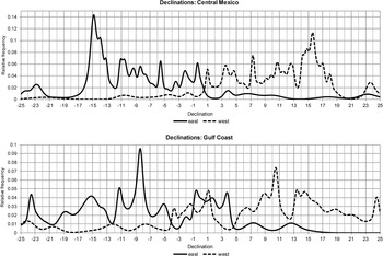
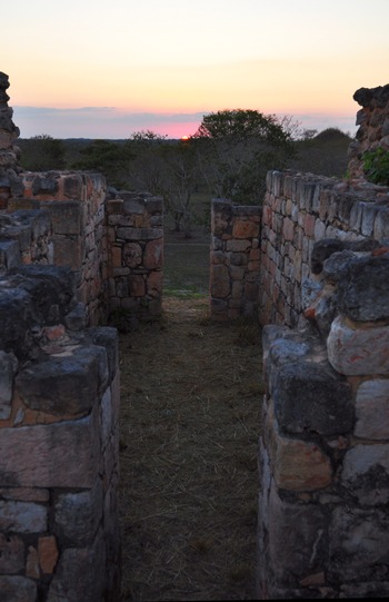
Figure 1 shows relative frequency distributions of declinations marked on the eastern and western horizon by orientations in two Mesoamerican regions (for other areas, see publications cited above). If equinoctial orientations had been common in Mesoamerica, the distribution of the corresponding declinations would exhibit a concentration centered on 0°. In fact, the peaks are found closer to −1° (declinations east) and 1° (declinations west). Since the dates corresponding to the former, falling before/after the spring/fall equinox, do not have any conceivable significance, the orientations of this group were most likely functional to the west, marking sunsets on March 23 and September 21 (±1 day), which are the so-called quarter-days of the year (when the Sun's declination is about 0.8°): falling two days after/before the vernal/autumnal equinox, these dates divide each half of the year delimited by the solstices in two equal parts of about 91 days. The existence of this orientation group was first noted by Ponce de León (Reference Ponce de León1982, Reference Ponce de León H., Broda, Iwaniszewski and Maupomé1991) and Tichy (Reference Tichy1991). The solstitial and quarter-day orientations occur throughout Mesoamerican history (Figure 2), but predominate in early sites, suggesting that these four moments represented the most elementary references in monitoring the seasons of the year: if the solstices, marked by easily perceivable extremes of the Sun's trajectory along the horizon, served for halving the seasonal year, the next step in timekeeping must have been the determination of mid-points in time between the solstices (Šprajc Reference Šprajc2018, and bibliography therein).
Relative frequency distributions of declinations marked on the eastern and western horizon by architectural orientations in two Mesoamerican regions (central Mexico: n = 69; Gulf Coast: n = 56); only declinations within the solar span are shown (based on data published in Šprajc Reference Šprajc2001; Šprajc and Sánchez Reference Šprajc and Nava2015).

Oxkintok, Yucatan, Mexico, sunset on a quarter-day (March 22, 2011) along the axis of the upper room of the Classic period Structure CA-14. Photograph by the author.

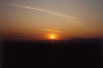
Aside from being astronomically oriented, many important buildings were located on places that allowed prominent mountain peaks on the horizon to be used as natural markers of sunrises and sunsets on relevant dates, including quarter-days of the year. Particularly interesting examples are Teotihuacan and Cuicuilco, which are, paradoxically, two of the sites most invaded by modern equinoctial pilgrims. While at the astronomical equinoxes no phenomena can be observed that might corroborate the visitors’ preconceptions, both sites offer a visual spectacle on the quarter-days: observing on top of the Sun Pyramid at Teotihuacan, the Sun rises over Cerro Tepayo, a prominent mountain on the eastern horizon (Figure 3), while for an observer on the round pyramid at Cuicuilco, the rising Sun aligns with Cerro Papayo, a notable feature on the eastern horizon of the Valley of Mexico (Šprajc Reference Šprajc2000a, Reference Šprajc2001).
Teotihuacan, Mexico, sunrise on a quarter-day (March 22, 1993) over Mount Tepayo, observed from the top of the Sun Pyramid. Photograph by the author.

PUTATIVE EQUINOCTIAL ALIGNMENTS IN MESOAMERICA: A CRITICAL ASSESSMENT
Before examining the claimed equinoctial alignments in Mesoamerica, it seems necessary to call attention to some fundamental methodological guidelines for any serious archaeoastronomical study. If any alignment is to be explored for its astronomical potential, the corresponding data (azimuth, horizon altitude, declination, dates) must be sufficiently precise and reliable and can be obtained only by employing adequate measurement techniques and data reduction procedures, described in various publications (e.g., Aveni Reference Aveni2001; Hawkins Reference Hawkins1968; Ruggles Reference Ruggles1999; Sánchez and Šprajc Reference Sánchez Nava and Šprajc2015). However, an important and regularly more difficult task concerns the astronomically motivated intentionality of alignments. For any architectural orientation or alignment identified in an archaeological context, it is relatively easy to find an astronomical correlate, but to propose, with a reasonable degree of confidence, that the observed correspondence is not fortuitous, we need either independent contextual evidence suggesting an astronomical motive for the alignment in question (iconography, written sources etc.) or a statistically significant number of comparable alignments incorporated in a coherent or homogeneous set of archaeological features (i.e., of the same type and pertaining to the same cultural complex) and corresponding to the same declination, or both. On the other hand, the meaning of an alignment, or a coherent set of alignments with the same astronomical referent, can be properly understood only if we manage to find reasons for which the postulated astronomical phenomenon could have been significant to the society that produced the alignment(s). The viability of archaeoastronomical hypotheses is directly proportional to the degree of significance that can be assigned to the astronomical phenomena involved. Such significance is to be sought in the relationship of the astronomical phenomena with specific environmental and cultural facts (e.g., seasonal climatic changes, subsistence strategies, religion, political ideology; Aveni Reference Aveni and Aveni1989, Reference Aveni2003; Hawkins Reference Hawkins1968; Iwaniszewski Reference Iwaniszewski and Aveni1989; Ruggles Reference Ruggles1999; Šprajc Reference Šprajc2005).
In Mesoamerica, the contextual data allowing us to suppose that the orientation of a building was motivated by astronomical considerations are frequently ambiguous and, in most cases, non-existent. Therefore, convincing interpretations can rarely be achieved without analyzing a reasonably large sample of reliable and homogeneous alignment data. Due to disregarding the basic methodological requirements summarized above, many hypotheses about the meaning of orientations and other alignments in Mesoamerican architecture are questionable, difficult to verify, or entirely speculative, a criticism that also applies to the claimed equinoctial alignments. As will be shown below, these proposals are characterized by one or a combination of the following methodological flaws:
(1) Archaeological evidence is outweighed by the preconceived significance attributed to the equinoxes.
(2) The alignment or the observational scheme proposed has no support in material evidence.
(3) The interpretation is based on deficient or erroneous alignment data.
(4) The interpretation applies to subjectively selected alignments.
(5) Alternative interpretations are more likely.
In the following sections I discuss particular cases that most clearly illustrate the shortcomings listed above.
Archaeological Evidence Overridden by the Preconceived Significance of the Equinoxes
One of the earliest proposals about astronomical motives underlying the layout of Mesoamerican buildings was published in the 1920s, suggesting that Group E of Uaxactun, Guatemala, was an astronomical observatory, intended specifically for sighting the equinoctial and solstitial sunrises (Ricketson Reference Ricketson1928a, Reference Ricketson1928b). In the following decades, a number of other architectural compounds with a similar configuration have been found, most of them in the central Maya Lowlands. Commonly labeled E Groups, these architectural complexes deserve special attention because the early astronomical interpretation of Group E of Uaxactun was soon extended to other similar assemblages and may have been the very origin of the widespread idea about the importance of the equinoxes in the Maya area and in Mesoamerica in general. The astronomical uses commonly attributed to E Groups represent probably the most eloquent example of how a traditional prejudice is given greater weight than materially evidenced facts.
A typical E Group has a symmetrical ground plan, with its central axis running approximately east–west, from a pyramidal temple on the west side of a plaza to the center of an elongated platform that delimits the plaza on its east side and extends in a roughly north–south direction. The latter has no superstructures in the so-called La Venta type, which is the earliest variant of this assemblage. The Cenote type has a central building on the platform, slightly set backwards, whereas the Uaxactun type, the latest version of the complex, has two additional buildings on the platform's extremes (Chase and Chase Reference Chase, Chase, Freidel, Chase, Dowd and Murdock2017; Inomata et al. Reference Inomata, Triadan, Pinzón, Burham, Ranchos, Aoyama and Haraguchi2018). Most E Groups were built during the Preclassic period (around 1000 b.c. to a.d. 250).
For the eponymous Group E of Uaxactun, Ricketson (Reference Ricketson1928a, Reference Ricketson1928b) argued that, observing from the substructure of the western pyramid (Structure E-7-sub), the outer edges of Temples E-1 and E-3 on the extremes of the eastern platform recorded solstitial sunrises, whereas the equinoctial Sun rose over Temple E-2 in the middle of the platform. Soon afterwards, Ruppert (Reference Ruppert, Hay, Linton, Lothrop, Shapiro and Vaillant1940) noticed that other compounds of this type have different orientations and suggested that they had more ceremonial than observational functions. Accordingly, some scholars interpreted them as allegorical imitations of the astronomically functional template at Uaxactun (Aimers and Rice Reference Aimers and Rice2006; Aveni and Hartung Reference Aveni, Hartung and Aveni1989; Awe et al. Reference Awe, Hoggarth, Aimers, Freidel, Chase, Dowd and Murdock2017; Fialko Reference Fialko1988; Guderjan Reference Guderjan2006). On the other hand, Aveni and colleagues (Reference Aveni, Dowd and Vining2003) argued that the alignments incorporated in E Groups were astronomically functional, largely corresponding to solar positions on different agriculturally important dates. Nonetheless, and although it soon became evident that many E Groups were earlier than the supposed prototype at Uaxactun, it was still argued that their initial purpose was to record the solstices and equinoxes, but that this observational function was subsequently abandoned and replaced by a predominantly ritual use (Aimers and Rice Reference Aimers and Rice2006; Guderjan Reference Guderjan2006). It was also suggested that stone columns or wooden poles placed on the eastern platform could have served as markers of the equinoxes or solstices (Aimers and Rice Reference Aimers and Rice2006:80; Rice Reference Rice2007:155), although no specific evidence supports this hypothesis. All these conjectures share the prejudice that the only potentially significant moments of the tropical year were the equinoxes and the solstices.
E-Group assemblages have been found in a large number of archaeological sites, both in the Maya Lowlands and along the Pacific and Gulf coasts and adjacent highlands. Given the long-known diversity of their orientations, as well as the study by Aveni and colleagues (Reference Aveni, Dowd and Vining2003), it is surprising how often we can still read, even in some contributions in the recently published book on E Groups (Freidel et al. Reference Freidel, Chase, Dowd and Murdock2017), that the alignments incorporated in complexes of this type marked the equinoxes and solstices. Although some alignments approximate the equinoctial directions, such statements are inconsistent with what is known about the orientations of both E Groups and other buildings.
Supposing that the equinoctial alignments were inaccurate and more symbolic than observationally functional, they would have been distributed evenly both south and north of the true equinoctial direction; in fact, the orientations of most E Groups, indicated by their central axes, are skewed south of east, in agreement with the long-known trend observed in buildings of different types throughout the Maya Lowlands, as well as in other parts of Mesoamerica (Aveni Reference Aveni2001; Macgowan Reference Macgowan1945).
Conversely, even though the intended orientations of particular structures, due to their present state of conservation, often cannot be accurately determined, the analyses of large samples of alignment data from different Mesoamerican regions have revealed that the orientations marked astronomical events quite precisely. The solar orientations, which prevail, allowed the use of observational calendars composed of multiples of 13 or 20 days and intended for facilitating the scheduling of agricultural and related ritual activities. Low-precision alignments would have been useless for such purposes. Since we thus know which dates were most frequently recorded and particularly significant, it is worth noting that in several buildings, where the alignments that most likely served for observations are sufficiently well-preserved and can be measured with precision (e.g., the axes of symmetry of upper structures, indicated by double pairs of jambs), these dates are recorded with surprising accuracy (Figure 2; Šprajc Reference Šprajc and Ruggles2015b:Figures 52.3–52.8; Šprajc and Sánchez Reference Šprajc and Nava2015:Figure 4.22; Šprajc et al. Reference Šprajc, Nava and Ortiz2016:Figures 4.7 and 4.14).
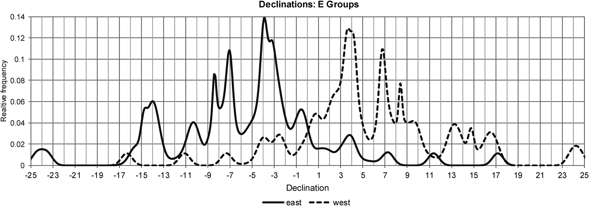
More specific conclusions regarding the astronomical significance of E Groups have been reached in a recent study of alignments in 71 complexes of this type in the central Maya Lowlands (Šprajc Reference Šprajc2021a, Reference Šprajc2021b). The analyses have shown that, although built primarily for ritual purposes, these assemblages were astronomically functional, but their use was not essentially different from that of other astronomically oriented buildings. While the distribution of lateral alignments (from the western building to the extremes of the eastern platform) offers no support to the idea that they were used systematically for sighting celestial events, the orientations of E Groups marked by their central axes belong to widespread alignment groups, mostly materialized in buildings of other types. With very few exceptions, the central axes lie within the angle of annual solar movement along the horizon, matching various dates commonly recorded by other buildings, often at one and the same site, but the equinoxes are not among them. In Figure 4, which shows the distribution of declinations marked by the central axes, there is no concentration centered on 0°, whereas the peak at 0.8° suggests that some near-equinoctial alignments targeted sunsets on the quarter-days. In sum, while a few E Groups were oriented to solstitial positions of the Sun, their relationship with the equinoxes can be safely rejected.
Relative frequency distributions of declinations marked on the eastern and western horizon by the central axes of 71 E Groups in the central Maya Lowlands; only declinations within the solar span are shown (based on data published in Šprajc Reference Šprajc2021a).

Paradoxically, even Group E of Uaxactun, which originated the most popular hypothesis about the astronomical significance of the compounds of this type, cannot be related to the equinoxes and solstices. According to archaeological excavation data, amply discussed elsewhere (Šprajc Reference Šprajc2021a, Reference Šprajc2021b), the allegedly solstitial and equinoctial alignments connect buildings from different periods and thus could have never been observationally functional (Kováč et al. Reference Kováč, Karlovský, Desprat, Navarro, Arroyo, Salinas and Paiz2015:1034; Rosal and Valdés Reference Rosal, Valdés and Valdés2005; Rosal et al. Reference Rosal, Valdés, Laporte, Laporte and Valdés1993; Valdés Reference Valdés1987).
The popular associations of E Groups with the equinoxes represent probably the most notorious example of preponderance of preconceptions over the available archaeological data. To mention but two more cases, Vadala and Milbrath (Reference Vadala and Milbrath2014) suggest that the orientation of the Late Preclassic Structure 4 of Cerros, Belize, targeted the equinoctial sunrises. As they recognize that its east–west axis, with an azimuth of 88°, corresponds to sunrises several days after/before the equinox, they assume that, due to the Sun's fairly rapid movement along the horizon around the equinoxes, the builders were able to establish only an approximate equinox alignment, perhaps by bisecting the angle delimited by solstitial directions, or by halving the time span between the solstices. However, given the difficulties mentioned above and the procedures leading to inaccurate results, it is hard to understand how the builders could have been aware of the equinox in the first place.
Similarly, Rice and Pugh (Reference Rice and Pugh2017:12) suppose that the orientations skewed 3–4° south of east, shared by the Middle and Late Preclassic E Groups at Nixtun-Ch'ich', Guatemala, and several other sites, suggest a calibration to an approximately eight-day period before the vernal and after the autumnal equinox. They also presume that the equinoxes, being difficult to determine with empirical observations, might have been estimated by counts of days from the solar zenith passages. But again, if the observers were unable to fix the equinox, they could not have known how many days to count. Instead, the orientations of E Groups of Nixtun-Ch'ich', apparently determinant of the main east–west axis of the site, belong to the most widespread alignment group materialized in the complexes of this type, corresponding to sunrises on March 11 and October 2, separated by 160 (= 8 × 20) days (Šprajc Reference Šprajc2021a, Reference Šprajc2021b).
Alignments Not Evidenced in the Archaeological Record
In some cases, two of which will be discussed below, the alignments claimed to be equinoctial are not indicated in material remains, or the observational scheme proposed has no support in archaeological evidence.
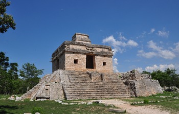
At Dzibilchaltún, in the northwestern extreme of the Yucatan Peninsula, Structure 1-sub, also known as the Temple of the Seven Dolls (Figure 5; Andrews and Andrews Reference Andrews and Wyllys Andrews1980), is one of the increasingly popular focuses of modern equinoctial pilgrimages, which reflect a common belief that the passage shaped by four east–west aligned doorways of the building was intentionally oriented to the rising Sun on the equinoxes (Casares Reference Casares Contreras2016; Dowd Reference Dowd, Dowd and Milbrath2015; Maldonado and Hernández Reference Maldonado Cárdenas and González2013; Méndez et al. Reference Méndez, Barnhart, Powell and Karasik2005). The widely publicized photographs showing the solar disk nicely framed by the doorways contribute to the popularity of the event. However, virtually identical photos can be taken from different points and on various consecutive days, but only after the Sun has reached a considerable altitude, because the orientation of the temple, skewed about 1° clockwise from cardinal directions, does not correspond to the equinoctial position of the Sun on the horizon. Since an exhaustive discussion of this case was presented elsewhere (Sánchez and Šprajc Reference Sánchez Nava and Šprajc2015:140–142; Šprajc and Sánchez Reference Šprajc and Nava2018), I will summarize only the most relevant facts.
Dzibilchaltún, Yucatan, Mexico, Temple of the Seven Dolls, looking southeast. Photograph by the author.

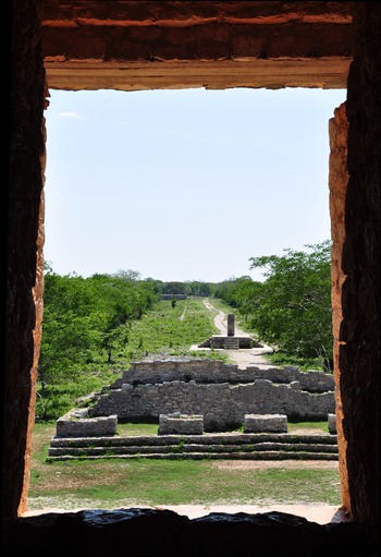
The causeway leading westward from the temple (Sacbé 1) is skewed 1°40' north of due west, and its central axis extended eastward passes a few meters north of the center of the temple (Andrews and Andrews Reference Andrews and Wyllys Andrews1980:14, Figure 2; Stuart et al. Reference Stuart, Scheffler, Kurjack and Cottier1979). Therefore, the convenient points for observing the phenomenon are located along a line running considerably south of—but not exactly parallel to—the central axis of the causeway, as well as several meters south of Stela 3, which stands on a platform in the middle of Sacbé 1, some 130 m west of the temple (Figure 6), and would thus appear to have been an appropriate marker of the observation spot. As a consequence, the multitudes visiting the site on the equinoxes concentrate in a space south of the stela, evidently searching for the most convenient spot for sighting the Sun through the temple's doorways. The central doorway of Structure 7, located about 40 meters west of Structure 1-sub, might represent another archaeologically preserved marker for observing the equinox Sun through the opening shaped by the four east–west aligned doorways of Structure 1-sub. However, from that vantage point, given the size of the opening, the Sun can be seen during various consecutive days at different altitudes, but there is no architectural element that would have allowed the observer to pinpoint the equinox date.
Dzibilchaltún, Temple of the Seven Dolls, looking west along the axis of symmetry of the western pair of doorways, with Structure 7, Stela 3, and Sacbé 1 in the background. Photograph by the author.

Instead, the orientation of the Temple of the Seven Dolls was likely functional in the western direction. Skewed about 1° north of west, it pertains to the widespread alignment group for which the sunsets on quarter-days of the year represent the only conceivably significant target. These dates could have been determined not only by direct observation of the setting Sun along the axis of symmetry of the four doorways (Figure 6), but also by observing light-and-shadow effects produced by pairs of windows and smaller openings in the eastern and western walls of the temple (Šprajc Reference Šprajc1995).
The ruins of the Templo Mayor of the Aztec capital of Tenochtitlan, in modern downtown Mexico City, represent another illustrative case. Referring to this building, the sixteenth-century friar Toribio de Benavente o Motolinía (Reference Motolinía and O'Gorman1971:51) writes that the Aztec feast of Tlacaxipehualiztli fell when the sun was in the middle of Uchilobos, which was the equinox. Since the temple is skewed notably south of east, Aveni and Gibbs (Reference Aveni and Gibbs1976) and Aveni and colleagues (Reference Aveni, Calnek and Hartung1988) proposed that the equinoctial observations were made from a spot at ground level west of the temple; given the building's height, the rising Sun would have appeared in the notch between the two upper sanctuaries only after it had moved considerably south of the east–west line. However, as extensively argued before (Šprajc Reference Šprajc2000b, Reference Šprajc2001:402–410), the hypothesis is hardly acceptable because, as the temple grew in height, the observation point would have had to be moved either farther away or to a higher level above natural ground; neither of the two scenarios finds support in archaeological evidence. Precise measurements in the Templo Mayor precinct revealed that one of the two sunset dates matching the east–west axis of the temple's late construction stages is April 4, which in the sixteenth-century Julian calendar corresponded to March 25, which in 1519 was the last day of the month of Tlacaxipehualiztli, and we can recall that the main feast of every month was celebrated on its last day (Caso Reference Caso1967; Prem Reference Prem2008). On the other hand, March 25, the Feast of the Annunciation, was commonly identified in medieval Europe with the vernal equinox (the canonical date of the ecclesiastical equinox established in a.d. 325 by the Council of Nicaea was March 21, but the Roman tradition associating the equinox with March 25 also survived: McCluskey Reference McCluskey, Ruggles and Saunders1993; Newton Reference Newton1972:22–27). We can thus conclude that Motolinía (Reference Motolinía and O'Gorman1971:51) did not refer to the astronomical equinox (the date of which would hardly have been known to a non-astronomer at that time), but rather only noted the correlation between the day of the Mexica festival—which in the last years before the Conquest coincided with the sunset along the axis of the Templo Mayor—and the date of the Christian (Julian) calendar that corresponded to the traditional day of the spring equinox. The dates marked by the building could be incorporated in an observational scheme composed of calendrically significant intervals. Also worthy of note is that orientations similar to that of the late stages of the Templo Mayor of Tenochtitlan (5°36' south of east) were identified in the neighboring area of Texcoco (Šprajc Reference Šprajc2001).
Interpretations Based on Deficient or Erroneous Alignment Data
As discussed earlier, any assessment of putative astronomical alignments must be based on reliable data (azimuth, horizon altitude). Since incomplete or imprecise data are given in a number of publications, the astronomical interpretations cannot be verified. As discussed by Šprajc and Sánchez (Reference Šprajc, Nava, Šprajc and Pehani2013), the orientation of the so-called Aposento de Moctezuma on the eastern slopes of Cerro de Chapultepec in Mexico City, related to the equinoctial sunrise by Galindo (Reference Galindo Trejo2003), cannot be established with precision, whereas Hohmann's (Reference Hohmann1995:104–106, Figure 195) equinoctial interpretation of the east–west alignment composed by Structures 9N-81 and 9N-83 in the Sepulturas group at Copán, Honduras, does not take into account the fact that, given the altitudes of the eastern and western horizon (more than 6° and 2°, respectively), the alignment corresponds to neither sunrises nor sunsets at the equinoxes, but may have been intended to record sunsets on the quarter-days of the year.
Exploring possible astronomical aspects of the Caracol tower at Chichen Itza, Yucatan, Mexico, Aveni and colleagues (Reference Aveni, Gibbs and Hartung1975) suggested that the diagonal line from inner right to outer left jambs of the west-facing window 1 corresponds to equinoctial sunsets. While a photograph supports their finding (Aveni et al. Reference Aveni, Gibbs and Hartung1975:Figure 9), they were careful enough to mention both the possibility that some of the blocks composing the window have shifted from their original positions and the difficulties involved in observing the event (which could be seen only from the floor level, due to the oddly inclined and apparently misplaced block of the inner right jamb). For these reasons they admitted that the “solar equinox alignment in window 1 remains problematical” (Aveni et al. Reference Aveni, Gibbs and Hartung1975:985). The fact that no other similar devices have been found further weakens the intentionality of this alignment, and even of other astronomical sightlines that they suggest were incorporated in the Caracol. Based on these and other arguments, Schaefer (Reference Schaefer, Bostwick and Bates2006a, Reference Schaefer, Bostwick and Bates2006b) dismissed their hypotheses, but it is fair to add that his harsh criticism, even if some issues are hardly debatable, contains assertions that are clearly objectionable (see rebuttals by Aveni Reference Aveni, Bostwick and Bates2006a, Reference Aveni, Bostwick and Bates2006b).
In other cases, of which only a few will be mentioned here, the hypotheses derive from evidently erroneous data. Córdova and Martínez (Reference Córdova Tello, Mora, Tello, Mora and Espinoza2012:28) relate the east–west axis of the archaeological site of Tamtoc, San Luis Potosí, Mexico, with the rising Sun on the equinox. However, not a single, even approximate equinoctial alignment can be identified in architectural orientations and overall layout of this site (Šprajc and Sánchez Reference Šprajc and Nava2015:79).
Coggins and Drucker (Reference Coggins, Drucker and Aveni1988) defined the group of the Temple of the Seven Dolls of Dzibilchaltún as an equinoctial observatory. However, as argued elsewhere (Sánchez and Šprajc Reference Sánchez Nava and Šprajc2015:141–143), their proposal about the importance of equinoxes, aside from depending on their interpretation of iconographic elements, is flawed by erroneous dates associated with the alignments.
Affirming that the early Middle Preclassic stages (ca. 900–600 b.c.) of Structure 19 on Mound 1 San José Mogote, Oaxaca, Mexico, are skewed 8° north of east, while the subsequent stages adopted a true east–west orientation, Flannery and Marcus (Reference Flannery and Marcus2015:7, 15, 17–19, 86–87, 119, 141; Marcus and Flannery Reference Marcus and Flannery2004:18258) associate these orientations with the equinoxes and the solstices. Field measurements at the site revealed that Structure 19 maintained the same orientation throughout its construction stages; with an azimuth of about 93.5°, it must have been intended to record sunsets on March 31 and September 12, separated by 200 (= 10 × 20) days and marked by other Middle Preclassic structures (Šprajc Reference Šprajc2018:232–233; Šprajc and Sánchez Reference Šprajc and Nava2015:44–49). Since the orientations marking calendrically significant intervals would have been useful only in association with the formal calendrical system, it is noteworthy that the existence of the 260-day count in mid-first millennium b.c. is attested in Monument 3 of San José Mogote (Flannery and Marcus Reference Flannery and Marcus2015:180–192).
For the Late Classic (ca. a.d. 600–800) Structure A-6 of Acanceh, Yucatan, Mexico, Quintal and Casares (Reference Quintal Suaste, Contreras and Salas2014) suggest that the central axis of the substructure records sunsets on the equinoxes, its azimuth and the corresponding horizon altitude being 268° and 5°, respectively. Such a horizon altitude, which they also assign to other putative astronomical alignments, is inconceivable in the flat landscape of the northern Yucatan Peninsula, invalidating their proposals.
Interpretations Based on Subjectively Selected Alignments
In a number of cases, the claimed equinoctial alignments were selected subjectively, apparently only because they fit the hypothesis. For example, Méndez and colleagues (Reference Méndez, Barnhart, Powell and Karasik2005) found an equinoctial alignment in the Temple of the Sun at Palenque, Chiapas, Mexico. In fact, in the complex architectural configuration of this building and in its relationship with others and with the surrounding landscape, they identified a number of alignments, relating them to the Sun's positions on the solstices, the equinoxes, the days of its zenith and nadir passages, and the extreme (standstill) positions of the Moon. The fact that, aside from the solstices, none of the dates most commonly recorded by axial orientations in the Maya area appears among the astronomical referents of these alignments raises the suspicion that their selection was not objective, encompassing all possible visual lines, but guided by prejudices about the importance of certain phenomena. Besides, as shown elsewhere (Sánchez and Šprajc Reference Sánchez Nava and Šprajc2015:173–174), the data provided for some of the alignments discussed do not correspond to reality.
Similarly, Lelgemann (Reference Lelgemann1996) relates several alignments in the Ciudadela compound at La Quemada, Zacatecas, Mexico, to the equinoxes and the solstices, but the architectural elements they are composed of are of different types (corners of the patio, of the central altar and of the annexed pyramid, a column, a jamb, the diagonal between two stelae found in the central altar) and seem to have been selected arbitrarily. Furthermore, the phenomenon of light and shadow observed on the equinox occurs half an hour after sunrise (Lelgemann Reference Lelgemann1996:106–107, Figure 4). There is no doubt that comparably impressive phenomena, produced by other architectural elements, could be observed on other dates and times of the day.
According to Tomasic (Reference Tomasic2009), some archaeological sites in the Holmul region, Guatemala, are located along the solstitial and equinoctial lines. Since only three alignments are discussed, and given their estimated errors of up to 2°, their possible astronomical correlates cannot be determined with any confidence. Moreover, two architectural groups claimed to mark the equinoctial and summer solstice sunrises, observing from Holmul, were found as a result of survey transects made in these directions precisely because of their preconceived astronomical significance, a procedure raising legitimate methodological objections: considering the high settlement density in the Maya Lowlands, one can only wonder how many other sites or architectural compounds would have been found had the surveyors followed other directions. Clearly, only objectively collected data on site distribution and typology in an area may serve as a reliable basis for assessing possible astronomical potential of intervening alignments.
Aveni and Hartung (Reference Aveni, Hartung and Tichy1982) mention that the alignment involving the Pyramid of the Sun at Teotihuacan and two petroglyph complexes located to the west (labeled TEO 11 and TEO 16) marks the equinoctial sunsets with considerable accuracy. As already argued by Ruggles and Saunders (Reference Ruggles and Saunders1984), the problem concerning the intentionality of this alignment is that the two groups of rock carvings are of different types and that there is a large number of petroglyphs in the area of Teotihuacan.
Alternative Interpretations Are More Likely
The proposals discussed below are based on reliable alignment data, but the cases are rather exceptional and, in the light of contextual and comparative data, the purpose of recording the equinoxes is less likely than other explanations.
As pointed out by Galindo (Reference Galindo Trejo1996) and confirmed by my measurements, the Postclassic Templo de las Caritas at Cempoala, Veracruz, Mexico, faces quite accurately the sunrises at the equinoxes. However, considering that this orientation also matches sunsets on the quarter-days and that the nearby Templo Mayor has a very similar orientation, but less compatible with the equinoctial sunrises, it is much more likely that both structures were intended to record sunsets on the quarter-days. Possibly the structure called El Pimiento marked the same dates, although on the eastern horizon (Šprajc and Sánchez Reference Šprajc and Nava2015:57).
Aveni and colleagues (Reference Aveni, Hartung and Charles Kelley1982) proposed that one of the factors that conditioned the location of Alta Vista, Zacatecas, Mexico, was the equinoctial alignment marked by Mount Picacho on the eastern horizon and materialized in a passage in the compound called El Laberinto. Furthermore, Medina and García (Reference Medina González and García Uranga2010:195) reported that the equinoctial Sun rose along the diagonal of the Southwest Plaza. Both alignments, indeed, correspond almost exactly to the equinoctial declination of the Sun. Their astronomically motivated intentionality is likely, considering that both the passage of El Laberinto and the diagonals of the two main quadrangles of the sites are aligned to prominent mountains (Šprajc et al. Reference Šprajc, Nava and Ortiz2016:19–24, Figures 4.1–4.4). Since many Mesoamerican buildings are oriented both astronomically and to conspicuous peaks on the local horizon, such correspondences cannot be attributed to chance (Šprajc Reference Šprajc2018:218). However, in light of the data from the rest of Mesoamerica, it seems unlikely that the concept of the equinox would have been known in a peripheral region. Even if such a possibility cannot be discarded a priori, an alternative explanation seems more plausible. The fact that the sunrise dates matching the passage of El Laberinto and the diagonal of the Southwest Plaza coincide with the equinoxes may well be fortuitous; rather than reflecting the builders’ awareness of the equinox, these dates must have been significant because, together with those marked by the diagonal of the Southeast Plaza on the western horizon, they could have been incorporated in a single observational calendar composed of multiples of 20 days (Šprajc et al. Reference Šprajc, Nava and Ortiz2016:19–24, Table 4.1). More data on architectural orientations in northwestern Mesoamerica would be needed to support this hypothesis. In the light of the currently available evidence from other regions, however, it seems more likely than the equinoctial one: in contrast to the absence of equinoctial orientations, the orientation patterns documented throughout Mesoamerica clearly reflect the use of observational calendars composed of calendrically significant intervals.
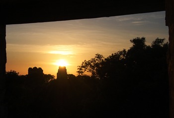
Another interesting example is the line connecting the centers of the entrances to the upper sanctuaries of Temples I and III of Tikal, Guatemala. The azimuth of this line, determined by both Aveni and Hartung (Reference Aveni, Hartung and Aveni1988:9, 12) and my own measurements, is 269°54'. Although this line reproduces almost exactly the true east–west direction, it can hardly be related to the equinoxes, as suggested by Aveni and Hartung (Reference Aveni, Hartung and Aveni1988) and Malmström (Reference Malmström1997:169–171), because the equinoctial sunrises or sunsets along this alignment could have been observed only on the natural horizon (with an altitude of about 0°). In fact, due to their heights, both temples mutually block the view to the horizon. As already pointed out by Hartung (Reference Hartung and Aveni1980:148), there was evidently no opening in the back wall of either building, hence the equinoctial observations were not possible once the construction was completed. While the existence of non-functional, merely symbolic alignments cannot be discarded, such a hypothesis in this case can hardly be substantiated, both because of the lack of equinoctial alignments in Mesoamerica and because the case at hand has a more plausible rationale. Observing in front of the upper sanctuary of Temple I westward, the angular altitude of the roof comb of Temple III is 3°36'; the declination corresponding to this altitude and the azimuth of 269°54' is 0°55'. Inversely, observing from the entrance to the sanctuary of Temple III, the roof comb of Temple I, rising to 2°36' of altitude, marks the declination of 0°47' (originally the roof combs could not have been much higher). Remarkably, the two declinations are very similar, corresponding to the positions of the Sun on the quarter-days of the year (Figure 7). It seems very likely that the relative placement of both temples and their heights were conditioned by the purpose of recording these dates, not only because they are marked by a number of orientations, but also because, observing from Temple IV, the Sun rises aligned with Temple III at the December solstice (recall that quarter-days are mid-points in time between the solstices) and with Temples I and II on two other significant pairs of dates (February 12 and October 30, and February 9 and November 1; Sánchez and Šprajc Reference Sánchez Nava and Šprajc2015:192–197).
Tikal, Peten, Guatemala, the rising Sun over the roof comb of Temple I, observed from the upper sanctuary of Temple III on a quarter-day (September 21, 2011). Photograph by Dieter Richter.

Light-and-Shadow Phenomenon at Chichen Itza
The most famous Mesoamerican building believed to reflect the importance of the equinoxes is undoubtedly El Castillo of Chichen Itza, also known as the Pyramid of Kukulcán. Being a rather singular case, it does not neatly fit any of the above categories of methodological inconsistencies and will be discussed separately.
Every year on the vernal equinox, thousands of visitors gather to watch the light-and-shadow effect produced in the late afternoon on the northern balustrade of the pyramid, giving the impression of a descending rattlesnake with illuminated dorsal triangles. The ophidian heads at the base of the northern stairway make this visual effect even more persuasive. The popularity of the phenomenon, first described by Rivard (Reference Rivard1969) and Arochi (Reference Arochi1976), is also mirrored in numerous publications interpreting it as the result of a carefully planned architectural design, whose objective was to record the equinoxes (see a summary in Carlson Reference Carlson1999).
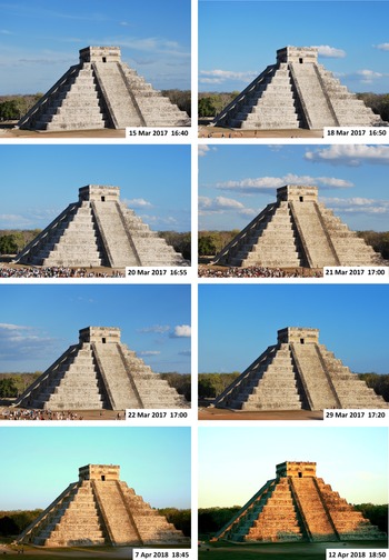
However, some researchers have noted that the interplay of light and shadow can be observed also a few days before and after the equinox (Aveni et al. Reference Aveni, Milbrath and Lope2004). In fact, a series of photographs taken in 2017 and 2018, from March to May every day, from 3 p.m. to sunset, at five-minute intervals, revealed that the phenomenon can be observed over a much longer period, at least from early March to mid-April. As the Sun goes down, the stepped bodies of the pyramid are projected onto the west face of the northern stairway. The increasingly jagged shadow rises and its tips begin to touch the edge of the balustrade, starting at the top and ending at the bottom, until several illuminated triangles are formed. The photos in Figure 8 were all taken at the moment when all triangles have formed, their apices touching the upper edge of the balustrade. In mid-March this occurs about 1.5 hours before sunset, when six triangles can be observed, while on subsequent days this moment approaches the time of sunset and the number of triangles increases. It has been suggested that the seven illuminated triangles and six intermediate shadows, appearing at the equinoxes, support the intentionality of the solar “hierophany,” considering that 13, the sum of these elements, had an obvious calendrical and symbolic significance. However, the seventh triangle begins to appear at the lower extreme of the stairway a few days before the March equinox, and since the whole set of seven triangles also can be seen during several following days, it could not have served as an accurate marker of the equinox.
Chichen Itza, Yucatan, Mexico, light-and-shadow effect on the northern stairway of El Castillo on several dates in March 2017 and April 2018. Note that the hours in April correspond to the summer (daylight saving) time. Photographs by Miguel Ángel Cab Uicab and Mariana Hernández Blanca.

Furthermore, there is no indication of a special importance of the seven triangles. In early April the number of triangles increases to eight, and in mid-April even the ninth triangle begins to form. It can barely be seen nowadays because the trees growing west of the Great Platform supporting El Castillo cast their shadows onto the lower part of the pyramid a few minutes before sunset, but likely would have been visible during the apogee of the city. One could suggest that the appearance of nine triangles, evoking the number of layers of the Maya underworld, was even more significant. However, since the daily variations are hardly noticeable, no date could have been determined by observing this phenomenon only.
In the attempt to interpret the luminous effect in a different way, Casares (Reference Casares Contreras2021) contends that, according to his observations in 2016, 2017, and 2018, the array of nine triangles appeared for the first time on April 9. Strangely, however, in his illustration (Casares Reference Casares Contreras2021:Figure 8), supposed to support the statement, only eight illuminated triangles can be seen, and my own Figure 8 shows that the ninth triangle was not completely visible even on April 12, 2018. For the other half of the year, Casares affirms that the nine triangles are visible for the last time on September 2 (when the Sun has the same declination as on April 9), but this date is thus also incorrect. It would be a digression to comment on other questionable parts of his argument, but his selection of the two dates seems to have been based on their preconceived significance derived from the conjecture that, falling 73 days before and after the June solstice, they had a connection with the 584-day synodic period of Venus (584 = 8 × 73). Although the interval of 584 days leads from September 2 to April 9, Venus would not have been visible on both dates in the same place of the sky, as Casares (Reference Casares Contreras2021:57) implies: after 584 days the planet returns to approximately the same apparent position relative to the Sun, but not relative to the starry background or the horizon, because its coordinates (right ascension and declination) do not repeat at 584-day intervals.
Returning to the equinoctial “hierophany,” it was suggested that its intentionality is supported by a comparable light-and-shadow effect produced around the December solstice on the northern stairway of a similar pyramid at Mayapan, also known as El Castillo (Arochi Reference Arochi, Broda, Iwaniszewski and Maupomé1991; Aveni et al. Reference Aveni, Milbrath and Lope2004). But also in that case the phenomenon is observable during about a month before and after the solstice, likewise with a varying number of triangles, and thus could not have served for determining any date either. Another allegedly significant detail of El Castillo at Chichen Itza was adduced by Rivard (Reference Rivard1969:52): of its four stairways, only the northern one, on which the illumination is produced, is decorated with snake heads at its base. However, this fact may well have a simpler explanation: the northern stairway ascends to the main entrance of the upper sanctuary, which faces north, in the direction of the sacred cenote to which a broad causeway leads. Besides, according to the sixteenth-century bishop Diego de Landa, the snake heads adorned the bases of the four stairways, although their presence has not been confirmed archaeologically (Tozzer Reference Tozzer1941:178).
To summarize, the light-and-shadow effect at Chichen Itza can be observed during several weeks; the day-to-day variations are barely perceptible, making it unsuitable for determining specific dates; the number of triangles varies, depending on the date and hour of observation; and there is no clue as to what the purpose of the builders might have been. Given these facts and the absence of comparable cases, the most prudent conclusion is that the phenomenon is accidental. Even assuming that it had a symbolic rather than observational function (Aveni Reference Aveni2001:295, 298–299), there are no grounds to suppose it commemorated the equinoxes; after all, the triangles are better defined and the whole display is visually more attractive only after/before the spring/fall equinox, in early April and early September (Figure 8).
FINAL REMARKS
Recent systematic studies in different parts of Mesoamerica have led to considerable advances in the understanding of astronomical principles materialized in architectural orientations. Analyses of large samples of alignment data have revealed the existence of various orientation groups, most of which recorded sunrises and sunsets on agriculturally significant dates. While the declinations marked by one prominent group are concentrated near the value of 1°, corresponding to the quarter-days of the year, the absence of any clustering around the equinoctial value of 0° makes the existence of orientations targeting the true equinox utterly unlikely.
A number of architectural alignments studied in Mesoamerica has been interpreted as reflecting the purpose to record the equinoxes. By examining various proposals of this kind, I have argued that for the most part they do not withstand critical scrutiny. Rather than being based on the available material evidence, such interpretations are subjective, lacking methodological rigor, and biased by preconceptions concerning the importance of equinoxes in prehispanic times. In some cases, they rely on deficient, imprecise, or erroneous data. In others, the claimed equinoctial alignments are not attested in material vestiges, but were constructed on the basis of certain conjectures. Subjectively selected alignments, apparently because they fit the hypothesis, represent another common problem. Many proposals suffer from a combination of these issues. In very few cases the alignments matching the equinoctial positions of the Sun are clearly embedded in architectural vestiges, but their scarcity, as well as other possible explanations that have been mentioned, make the intent of recording the equinox unlikely.
Since the architectural orientations related to the Sun evidently marked the dates that were significant it is reasonable to suppose that, had the equinoxes been important in Mesoamerica, they also would have been targeted by alignments. While we could still surmise that the concept of the equinox was known, but for some unknown reason had no role in orientation practices, the evidence to this effect is scant and ambiguous at best.
It has been argued that the equinoxes are recorded in Maya codices and monumental inscriptions. Indeed, several calendrical records in the Maya texts correspond to the equinoctial or near-equinoctial dates (e.g., Bricker and Bricker Reference Bricker and Bricker2011; Bricker and Vail Reference Bricker and Vail1997; Zender Reference Zender2004:253–254). However, there are no unequivocal data indicating that their purpose was, indeed, to record the equinoxes, rather than other events (Velásquez et al. Reference Velásquez García, Galindo Trejo, Iwaniszewski, de Velasco and Vega2011:147). Although the Maya Long Count dates can be correlated with our own calendar with reasonable confidence, epigraphic evidence is, in fact, not sufficiently reliable for assessing the potential importance of certain dates in the tropical year, because of the lack of consensus regarding the exact value of the correlation constant and considering that slightly different values might apply in different periods (cf., Martin and Skidmore Reference Martin and Skidmore2012). Furthermore, since many dates in the codices are not tied to the Long Count, their absolute positions in time, proposed by different authors, depend on their specific interpretations of contextual information, making such hypotheses difficult to verify.
Where the equinoxes are mentioned in ethnographic works, the term seems to be used as an approximate and Western-based seasonal reference, rather than as a specific date given by informants (e.g., Gossen Reference Gossen1974; Gutiérrez del Ángel Reference Gutiérrez del Ángel2010; Prechtel and Carlsen Reference Prechtel and Carlsen1988). There is no doubt that people whose lifestyle compels them to keep track of the seasonal environmental changes are aware of the days when the rising or setting points of the Sun are roughly equidistant from the solstitial extremes, or when day and night are of about equal length. But I have never found an indigenous definition or explanation of a concept equivalent or comparable to the equinox, nor any description of the method employed to determine such a moment. Particularly illustrative and explicit in this sense is the ethnographic information given by Vogt (Reference Vogt1997:111) for the Tzotzil Maya of Zinacantan, in the highlands of Chiapas, Mexico: while they are acutely aware of the solstitial positions of the Sun (marked also by orientations: see declinations clustered around ±23.5° in Figures 1 and 4), and even have names for the solstices in their own language, there are no words in Tzotzil to describe the equinox; nor do the modern Zinacantecos seem to be aware of the equinox positions of the Sun on the horizon. On the other hand, the observations of the Sun relative to horizon features have been documented in various communities (Fought Reference Fought1972:386, 435; Lincoln Reference Lincoln1945; Tedlock Reference Tedlock, Broda, Iwaniszewski and Maupomé1991:181), and it is precisely such horizon calendars that must have led to establishing the quarter-days.
Apparently, many researchers share the opinion that the “equinoxes” can be understood less precisely, merely as approximate dates. However, since the equinox is already precisely defined, it cannot be assigned other meanings. Aside from confusing, such a loose use of the term is misleading, as it implies the existence of a conceptual framework for which there is no evidence. Since archaeoastronomical studies are still viewed with skepticism by some archaeologists, a few words on the relevance of the problem are in order.
Many years ago, when much of archaeoastronomy was still characterized by an uninformative approach, devoid of social context, Kintigh (Reference Kintigh1992:1) aptly exposed the problem: “it may be true that a building is lined up within half a degree of true north, but what do I do with that singular fact?” Accordingly, since the directions to the equinox and quarter-day sunrises/sunsets differ by less than a degree, what might be the significance of accurately determining the intended target? An incorrect interpretation gives a false insight into the cognitive world of the society involved. Without taking into account hard data and by defining the alignment targets as equinoxes, many scholars have indulged in unproductive, ethnocentric and sweeping generalizations concerning the astronomical concepts in ancient societies. The awareness of the equinox in Mesoamerica would imply a profoundly different knowledge and would inevitably provoke a number of questions regarding the underlying intents, observational methods, and cosmological framework (cf., Ruggles Reference Ruggles1997). Alternatively, if the Mesoamericans were interested in quarter-days, as the evidence indicates, we can infer that their needs for timekeeping, basically conditioned by agricultural concerns, were solved by horizon-based counting of days from the solstices, a method that ultimately resulted in complex observational calendars. Furthermore, the architectural alignments based on astronomical criteria were not only embedded in important civic and ceremonial buildings of each settlement, but were also reproduced, albeit approximately and without being observationally functional, by many other constructions, frequently dominating considerable parts of the built environment and indicating an outstanding role of the underlying concepts in religion, worldview, and political ideology. As exemplified in a number of studies, it is precisely the significance of the astronomically and cosmologically important directions that allows us to understand some prominent aspects of architectural design and urban planning in Mesoamerica. In short, without having the correct data, we have no chance of answering the question most succinctly put by Aveni (Reference Aveni and Aveni1989:11): “What were they up to and why?”
RESUMEN
Los estudios arqueoastronómicos realizados durante las últimas décadas en Mesoamérica han demostrado que los edificios cívicos y ceremoniales fueron orientados, en gran parte, a partir de criterios astronómicos, mayormente hacia los ortos y ocasos del Sol en ciertas fechas, permitiendo de esta manera el uso de calendarios observacionales que facilitaron la programación de actividades agrícolas y ceremonias relacionadas. A pesar de los avances logrados en estas investigaciones, una de las ideas que siguen siendo populares, aunque carecen de sustento, es que muchos alineamientos registraban las posiciones del Sol en los equinoccios. Al examinar varias propuestas de esta índole y analizando sus deficiencias metodológicas, argumento que, en lugar de basarse en los datos fiables sobre los alineamientos, seleccionados objetivamente, estas hipótesis derivan del significado preconcebido atribuido a los equinoccios. En lugar de los equinoccios, las orientaciones casi equinocciales registraban los llamados días de cuarto del año, que ocurren dos días después/antes del equinoccio de primavera/otoño y subdividen cada mitad del año delimitada por los solsticios en dos partes iguales. Considerando que las direcciones astronómicamente significativas están materializadas en sectores importantes del entorno construido, resulta evidente que tuvieron un papel importante en la religión, la cosmovisión y la ideología política. Por lo tanto, la identificación correcta de sus referentes celestes, permitiendo interpretar de manera convincente su significado, intenciones subyacentes y prácticas de observación empleadas, es el requisito indispensable para poder profundizar en la comprensión de algunos aspectos sobresalientes del diseño arquitectónico y la planeación urbana en Mesoamérica.