

INTRODUCTION
In his satirical dialogue The Ship, or the Wishes (1), Lucian uses the port of the Piraeus as the backdrop for the arrival of a giant corn-freighter from Egypt that causes excited crowds to rush to the docks. Narrative style, content and literary tropes vividly evoke Plato's Republic and Phaedon, and leave no doubt that this is a fictitious setting, seen through the classicising lens of the Second Sophistic (Casson Reference Casson1950; Anderson Reference Anderson1977; Jones Reference Jones1986, 158; Houston Reference Houston1987). Yet the extraordinary size of the ship and the very fact of its unexpected arrival have frequently been taken a priori as sufficient evidence of the low frequency of maritime traffic into (and hence the insignificance of) the Piraeus during the Imperial period (Hertzberg Reference Hertzberg1866–8, 208; Panagos Reference Panagos1997, 185–9; Humphrey, Oleson and Sherwood Reference Humphrey, Oleson and Sherwood1998, 455). Although Lucian's text cannot be used as a basis for this pessimistic conclusion, such judgements reflect a continuous line of negative representations of the post-Classical port that can be traced from ancient Greek and Latin literary sources to historical works of the modern age (e.g. Kahrstedt Reference Kahrstedt1954, 260; Garland Reference Garland1987, 57, 59). Their persistence can be easily understood in the context of perceptions about Imperial Greece as a provincial backwater that more recent scholarship has begun to scrutinise on the basis of archaeological data (Alcock Reference Alcock1993; Reference Alcock and Mattingly1997).
The potential for a critical reassessment of the evidence relating to the Piraeus between its destruction by the Romans in 86 bc and Late Antiquity has not thus far been fully appreciated (for an exception see Day Reference Day1942, 121–5). As a result, interpretations such as the aforementioned still exert a powerful influence on our understanding of the physical appearance and function of the port, as well as its position within local and regional networks of the time. Of central importance for this reassessment is the examination of archaeological finds from rescue excavations conducted by the Greek Archaeological Service. Thus far, this body of material has been used to clarify issues relating to the topography and planning of the urban area in the Classical period (Hoepfner and Schwandner Reference Hoepfner and Schwandner1986, 12–20; Reference Hoepfner and Schwandner1994, 22–50; Eickstedt Reference Eickstedt1991; Steinhauer Reference Steinhauer, Greco and Lombardo2007; Reference Steinhauer, Vassilopoulou and Katsarou-Τziveleki2009). Drawing upon material from the rescue excavations as well as literary and epigraphic sources, the aim of this paper is to explore the changing landscape of the Piraeus, its infrastructure and the economic function of the port between the later first century bc and the sixth century ad. This reassessment permits a more complex understanding of the port's significance in the Roman period than was hitherto possible. It will also provide the initial groundwork for comparing the Piraeus with other Roman ports in the Aegean and the rest of the Mediterranean.
THE HISTORIC LANDSCAPE OF THE PORT AND THE SULLAN DESTRUCTION
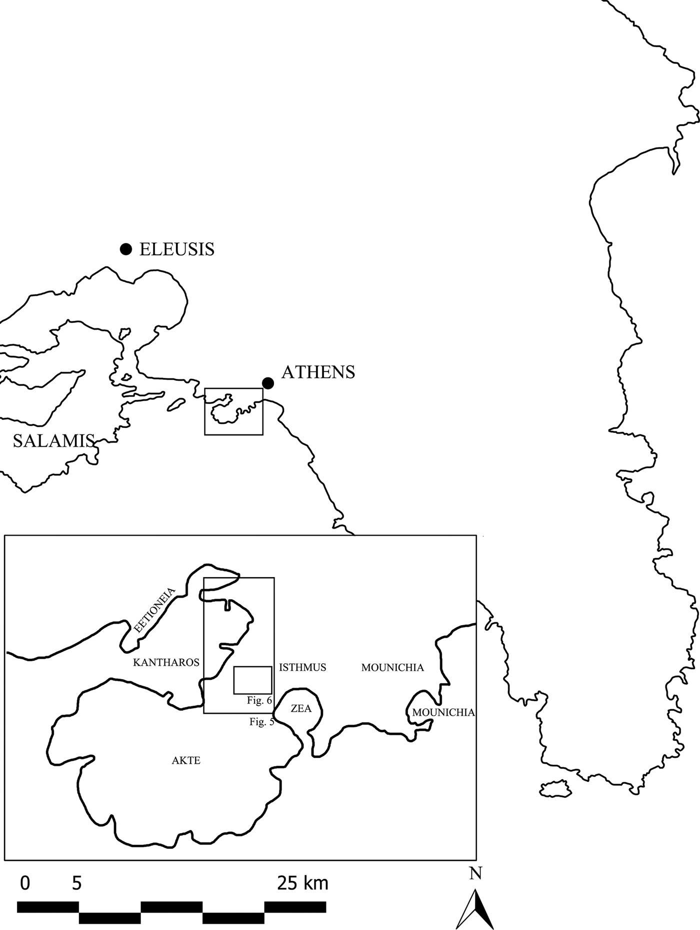
The Piraeus is a hilly peninsula of Cretaceous and Pliocene limestone and sandstone situated c.8 km south-west of Athens and bordering the alluvial plains of the Kephisos River to the north and north-east (Fig. 1). Its present-day topography is the result of uplift and erosion during the Pleistocene (Higgins and Higgins Reference Higgins and Higgins1996, 30–1), with recent geological research indicating that until c.1550 bc the peninsula was separated from Attica by a lagoon, verifying Strabo's etymology of its name as ‘the land beyond’ (Strabo 1.3.18; Goiran et al. Reference Goiran, Pavlopoulos, Fouache, Triantaphyllou and Etienne2011). Apart from the hill of Mounichia on the north-east, the main part of the peninsula consists of a central strip of low-hill terrain (the isthmus) which rises to the south to form an extensive rocky peninsula (the Akte). The distinctive feature of the topography consists of the three natural harbours, identifiable by their ancient Greek names: Kantharos on the west side of the isthmus, the circular harbour at Zea, and the small harbour of Mounichia on the north-eastern side of the peninsula (Eickstedt Reference Eickstedt1991, 9–15). Another protected cove lay to the north of the Kantharos and east of the Eetioneian peninsula. Extensive dredging and landfill operations after the refoundation of the port in the post-Ottoman period have altered the coastline along the eastern and northern waterfront of the Kantharos, leading to the disappearance of ancient harbour installations which had been visible until the beginning of the nineteenth century (Dodwell Reference Dodwell.1819, 420–3; Wachsmuth Reference Wachsmuth1890, 98). Evidence from submerged underwater remains of quarries and shipsheds at Zea indicates that the sea level has risen between 1.90 and 2.90 m since the Classical period; however, it is not clear when and at what rate the rise in the sea level occurred (Løvén et al. Reference Løvén, Steinhauer, Kourkoumelis and Nielsen2007, 68 and 69 fig. 8; Løvén Reference Løvén2011, 147–50).
Map of Attica and the Piraeus peninsula with place names mentioned in text.

Evidence for human settlement in the Piraeus stretches back into the prehistoric period but it was during the early fifth century bc that it became the stronghold of the growing Athenian navy. The peninsula was gradually transformed into an urban settlement with its own city walls and planned street grid (Garland Reference Garland1987, 163–5; Eickstedt Reference Eickstedt1991, 82–96; Hoepfner and Schwander Reference Hoepfner and Schwandner1994, 22–30; Gill Reference Gill2006); in the course of the 460s bc it was connected to Athens by means of roads and a set of linear fortifications known as the Long Walls (Conwell Reference Conwell2008; Petritaki Reference Petritaki, Vassilopoulou and Katsarou-Τziveleki2009a). With the exception of some parts of the urban fortifications and few remains of houses, archaeological evidence from the period of the city's foundation is limited, and most of the building remains date from the later fifth and fourth centuries bc, when – particularly during the ‘Lykourgan’ period – many building projects for the naval base, such as the Skeuotheke (arsenal) of Philon, were initiated. Literary sources and epigraphic evidence in the form of boundary stones suggest that the harbours were developed from early on as special zones with particular designated functions (Garland Reference Garland1987, 83–100; Eickstedt Reference Eickstedt1991, 63–8; Steinhauer Reference Steinhauer, Greco and Lombardo2007). The harbours of Zea and Mounichia were reserved for the fleet and constituted the naval base par excellence (Løvén Reference Løvén2011; Løvén and Schaldemose Reference Løvén and Schaldemose2011), while the Kantharos harbour served a range of functions, which included naval infrastructure and shipsheds as well as facilities for trade and commercial operations. The main features of the latter included five stoas, arranged between the southern and northern parts of the eastern shore (Steinhauer Reference Steinhauer, Greco and Lombardo2007; Reference Steinhauer, Vassilopoulou and Katsarou-Τziveleki2009). Other facilities, such as the diazeugma (an artificial pier for docking and for the offloading of ship cargoes), the choma (a jetty used for mustering ships’ crews) and the deigma (an area reserved for banking and the public display of commodities and samples of merchandise), are known almost exclusively from textual sources (Garland Reference Garland1987, 151–4; Eickstedt Reference Eickstedt1991, 62–6; Steinhauer Reference Steinhauer, Greco and Lombardo2007, 197–9; Reference Steinhauer, Vassilopoulou and Katsarou-Τziveleki2009, 187).
During the following centuries, the fortified urban area (c.5 km2 in total) became the epicentre of numerous military operations, culminating with the siege and sack by the Romans under the general L. Cornelius Sulla in 87/86 bc. During the fighting, the cemeteries and the Long Walls, which had lain in ruins since the end of the fifth century bc, were plundered for material for the construction of siege works and weapons (Kyriacopoulos Reference Kyriacopoulos1992), while the city walls, having been breached by the Romans, were apparently never rebuilt. Appian (Mithridatic Wars 30–41) and Plutarch (Sulla 14.6–7) relate that the port was burnt to the ground. Both make particular reference to the level of damage to the naval facilities at the Zea harbour (e.g. Philon's arsenal) and the fortifications, though the material evidence for this is patchy (Steinhauer Reference Steinhauer, Hoepfner and Schwandner1994a, 44–50; Palaiokrassa Reference Palaiokrassa1991, 43). Destruction deposits associated with the Sullan sack have been reported from several excavated plots, including sites with domestic buildings in the north part of the isthmus close to the landward defences and on the slopes of the acropolis hill of Mounichia (Grigoropoulos Reference Grigoropoulos2005, 20–2, fig. 13). Several of these sites have also yielded coin hoards containing the characteristic ‘star-and-crescent’ Athenian tetradrachms minted in haste prior to the siege (Kleiner Reference Kleiner1973; Oeconomides-Caramessini Reference Oeconomides-Caramessini1976; Grigoropoulos Reference Grigoropoulos2005, 24). It has also been posited that a destruction layer within the remains of a building on the north-east shore of the Kantharos, interpreted as part of a stoa or warehouse, that yielded a cache of Archaic and Classical sculptures, is related to the Sullan siege and sack (Garland Reference Garland1987, 190–1). Interpretations of this find vary, however: some see the sculptures as booty collected by the troops of Mithridates from Delos or by the Romans from sanctuaries in Athens and Attica; others see them as artistic treasures destined for export by the impoverished Athenians in an attempt to finance the city's defence on the eve of the siege by the Romans (Palagia Reference Palagia and Palagia1997).
SETTLEMENT CONTINUITY AND CHANGE AFTER 86 BC: THE EVIDENCE FROM RESCUE EXCAVATIONS
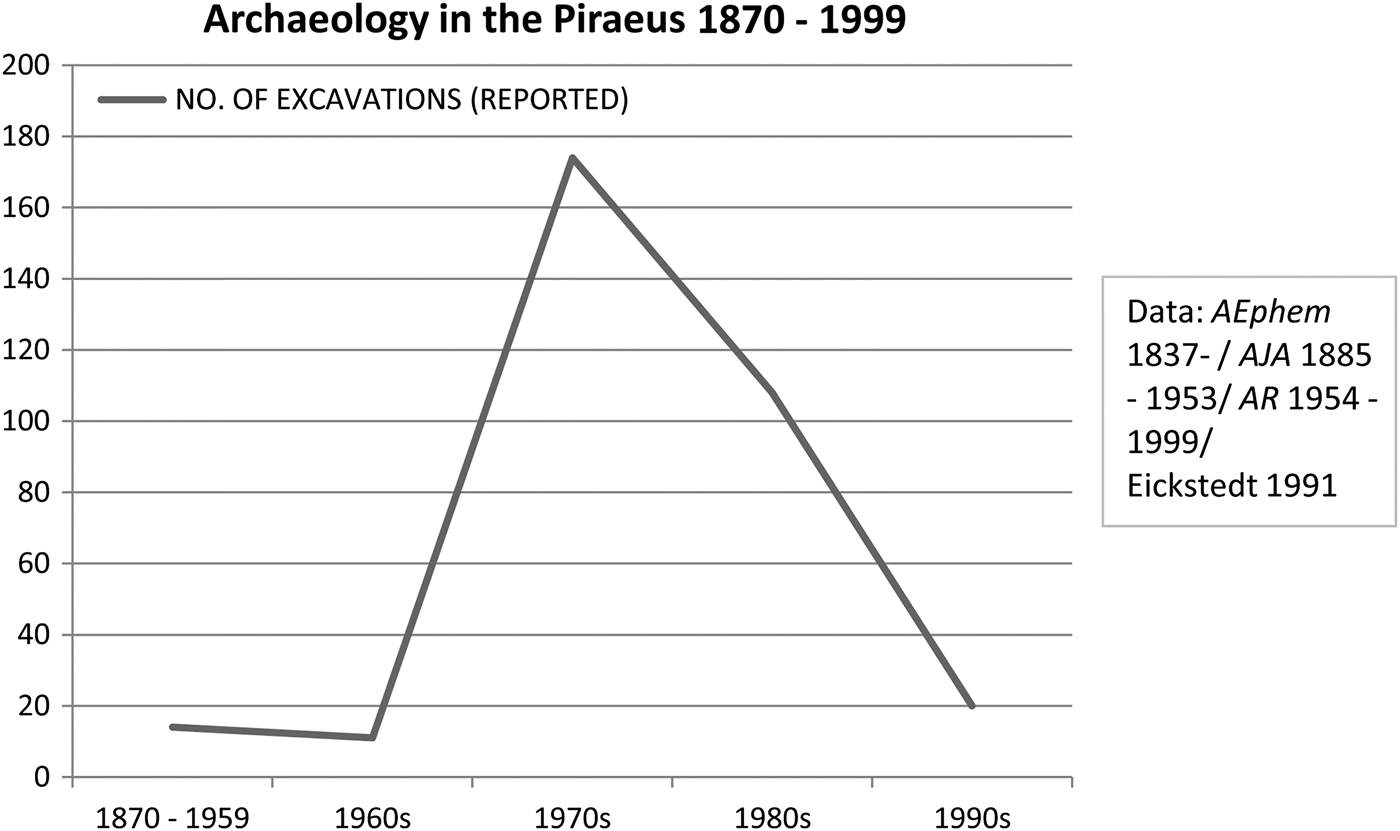
Cicero's reference to the Piraeus as a city in ruins (To his Friends, IV.5,4) and Strabo's comment (9.395–6) that in his day the port had been reduced to a small settlement (ὀλίγην κατοικίαν) have greatly influenced modern perceptions of the urban image as well as the extent and nature of settlement in the port during the Imperial period (e.g. Garland Reference Garland1987, 57; Eickstedt Reference Eickstedt1991). The historical evolution of the urban landscape can also be approached on the basis of evidence from rescue excavations. Archaeological exploration of the Piraeus began in the late eighteenth century and was intensified after the urban planning and refoundation of the city in 1834 following the transfer of the capital of the modern Greek state to Athens (Eickstedt Reference Eickstedt1991, 7–17; Malikouti Reference Malikouti, Steinhauer, Malikouti and Tsokopoulos2000). It was only in the latter half of the twentieth century, however, during the course of rapid urban development, that organised excavations by the Greek Archaeological Service were initiated on a large scale (Fig. 2). As is so frequently the case, these excavations generated masses of archaeological material, the vast majority of which has unfortunately not reached the stage of full publication. Nevertheless, given that the congested conditions of modern Piraeus do not lend themselves to extensive archaeological investigation, the material from these excavations forms the main body of evidence at our disposal.
Urban excavations in the Piraeus, late 19th – late 20th century.

Following Eickstedt's (Reference Eickstedt1991) seminal study, material from rescue excavations is now being increasingly integrated into more synthetic archaeological exploration and interpretation of ancient Greek urban sites (e.g. Lolos, Gourley and Stewart Reference Lolos, Gourley and Stewart2007; Sweetman Reference Sweetman2010). Ideally, rescue excavations provide stratified sequences of archaeological material that can be examined in a manner similar to urban surveys (e.g. Alcock Reference Alcock1991; Reference Alcock1993, 97–9; Bintliff Reference Bintliff, De Ligt, Hemelrijk and Singor2004) to track plot by plot the character and intensity of settlement on a diachronic basis both in quantitative and in qualitative terms. This type of analysis can be done by using a range of different indicators, such as the area occupied, the nature and extent of building or other activity and the range and volume of associated finds. For the Piraeus, such a study is not currently feasible, because a large number of preliminary site reports are not accompanied by sufficient chronological and/or spatial data. On a second note, problems also arise due to general lack of adequate stratigraphic information about the sequence of activity for many of the sites in question, as well as the nature of associated finds. Given these constraints, the available information can only be used in a rather general fashion, which nevertheless allows adequate scope for assessing chronological variation and shifts in function across the urban area.
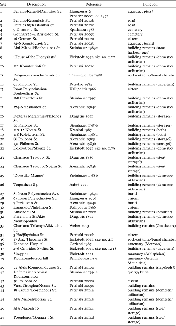
The plotting of dated material from rescue excavations reported by Eickstedt (Reference Eickstedt1991), along with more recent discoveries discussed by Petritaki (Reference Petritaki2000a; Reference Petritaki2000b; Reference Petritaki2002a; Reference Petritaki2002c; Reference Petritaki, Vassilopoulou and Katsarou-Τziveleki2009a; Reference Petritaki2009b; Reference Petritaki2009c; Reference Petritaki2010a; Reference Petritaki2010b; Reference Petritaki2010c; Reference Petritaki2014a; Reference Petritaki2014b; Reference Petritaki2014c; Reference Petritaki2014d), suggests that following an expansion in the fourth century bc, settlement during the Late Hellenistic period began to move away from the slopes of the Mounichia hill and the Akte towards the area of the isthmus (Fig. 3). Similarly, excavated plots with evidence for activity in the Imperial period and during Late Antiquity (Fig. 3; Table 1) show a settlement concentration in the area between the Kantharos and Zea harbours. Influenced by Strabo's comment, this pattern has been interpreted as the direct result of the Sullan destruction (Eickstedt Reference Eickstedt1991, 139). The decrease of settlement on Mounichia and Akte, however, is already documented for the third/second century bc and demonstrates that the decrease of the size of the urban area had started long before the Sullan sack. Similar processes have been documented in other Greek cities (Alcock Reference Alcock1993, 96–105; e.g. Thespiai: Bintliff Reference Bintliff, De Ligt, Hemelrijk and Singor2004). On the whole, it appears that the Roman port developed more or less over the same area as the Late Hellenistic settlement before the destruction of 86 bc. Rather than pointing to a dramatic decline, the pattern of urban settlement in the Imperial period appears thus to follow on from Hellenistic developments that had been set in motion before the Sullan destruction.
Distribution of sites with dating evidence excavated in the Piraeus by period (adapted from Eickstedt Reference Eickstedt1991).


The changes outlined above can be followed more closely on the basis of available evidence from the rest of the Piraeus peninsula (Fig. 4). A significant shift in land use has been documented for the area of the naval facilities at the Zea harbour and its immediate environs. So far these areas have furnished little evidence for activity in the Imperial and Late Roman periods and were either redeveloped or (apparently) abandoned (see below). Nor have the Akte peninsula and the slopes of the Mounichia hill (which were extensively settled in the Classical and Early Hellenistic periods) furnished any evidence for Roman building activity. There is a similar lack of concrete archaeological evidence attested for the Eetioneian peninsula, though epigraphic sources suggest that this part of the port remained in use during the Roman period (IG II2 1035, line 37; Culley Reference Culley1975; Reference Culley1977). The existence of a few underground burial chambers with Roman small finds and evidence for frescoes on the Akte and on the slopes of the Mounichia hill (Fig. 4 nos 11 and 35), together with the absence of other Roman residential activity, suggests that these areas probably lay at the extremities of urban space (Steinhauer Reference Steinhauer1989d, 26; Eickstedt Reference Eickstedt1991, 139 nos 4.1 and 4.2; Grigoropoulos Reference Grigoropoulos2005, 76–80).
Excavated sites with reported material of Roman Imperial to Late Roman date (adapted from Eickstedt Reference Eickstedt1991; for site numbers, see Table 1).

Tombs discovered within the Classical and Hellenistic urban area have been considered as a strong indication of urban decline (Eickstedt Reference Eickstedt1991, 139) but inferences based on this type of evidence alone must be treated with caution. The few solitary burials discovered close to the emporion date to the Late Roman period or even later (Fig. 4 nos 27, 29 and 41; Alexandri Reference Alexandri1984b; Steinhauer Reference Steinhauer1989a), and therefore are not relevant to developments in the Early Imperial period. Moreover, Roman tombstones reportedly discovered in the Piraeus are equally problematic in this respect, since their exact findspots and/or their original places of display are not known with certainty (Moock Reference Moock1998, 17–18). Furthermore, it must be remembered that burial in urban areas was not unusual as an expression of status in the Imperial period (Schörner Reference Schörner2007, 30–3) and therefore the occurrence of individual chamber tombs on the slopes of the Mounichia hill and the Akte may reflect special commemorative choices for specific individuals or social groups. In this context it is important to stress that the Roman port's organised cemeteries are located without exception outside the Classical fortification walls to the north of the Piraeus peninsula (e.g. Fig. 4 nos 4 and 5) and have frequently furnished evidence for continuous use from Classical and Hellenistic times (Raftopoulou Reference Raftopoulou1989, 30; Spathatou Reference Spathatou1988, 62; Eickstedt Reference Eickstedt1991, 255 [site no. 4.3]; Petritaki Reference Petritaki, Vassilopoulou and Katsarou-Τziveleki2009a, 465 [site no. 110]; Reference Petritaki2009b, 95; Bardani and Tsaravopoulos Reference Bardani and Tsaravopoulos2004–9). The persistence of this practice indicates that, despite their defunct state after the Sullan destruction, the ruined fortifications continued to fulfil a symbolic function as boundaries to the urban area.
On another level, the rhythm of recovery after the destruction of 86 bc can be gauged by means of the evidence for building activity and stratified Early Roman deposits. Archaeological evidence for public buildings in the port is scarce but a recent re-examination of masons’ marks from the theatre of Zea, constructed c.mid-second century bc (Fig. 4 no. 33), suggests that repairs or additions took place in the Augustan period (Weber Reference Weber2013, 55–7; Di Napoli Reference Di Napoli2013, 24–5). For the majority of sites, however, archaeological evidence for building activity of both domestic and public character is considerably later. A systematic study of the finds from the ‘Dikastiko Megaro’ site suggests that extensive modifications of the two courtyard houses date to a period between the second half of the first and the beginning of the second century ad (Fig. 4 no. 25; Grigoropoulos Reference Grigoropoulos2005, 261–72). Similarly, pottery from the upper fill of two cisterns excavated in two separate plots on the central part of the isthmus (Fig. 4 nos 13 and 30) and dated to a period between the later first and early second centuries ad, probably originated from nearby houses or other residential contexts (Kallipolitis Reference Kallipolitis1966, 67–70; Grigoropoulos Reference Grigoropoulos2005, 216–17 fig. 166–7). The presence of significant quantities of late second-/early first-century bc material (what, from an Athenian perspective, has been termed ‘Sullan debris’: Rotroff Reference Rotroff1997a, 35) in these contexts indicates that clean-up operations in the Piraeus continued for a considerable amount of time, and that urban reorganisation after the Sullan sack was slow, a pattern noted also in Athens (Rotroff Reference Rotroff, Hoff and Rotroff1997b, 100–1; Hoff Reference Hoff, Hoff and Rotroff1997, 40–1).
This examination of local long-term settlement patterns demonstrates that the reduction of the urban area of the Piraeus is a phenomenon not specific to the Imperial period. By the second century bc, settlement had already become concentrated between Zea and the Kantharos and this tendency appears to crystallise in the course of later centuries. While this question must be therefore considered within a long-term perspective, it should not be taken to mean that the destruction of the port in 86 bc did not affect urban settlement. Several areas of the Piraeus peninsula and parts of the harbours that were in use during the Late Hellenistic period indeed demonstrate few or no signs of Roman activity. More importantly, the types of Roman activity (e.g. tombs, private residences) observed in some cases contrast strongly with the evidence (both material and literary) for the function of the respective areas in the Classical and Hellenistic periods. All this would seem to suggest that significant shifts in settlement and the organisation of urban space took place following the Sullan destruction and during the course of the first century bc. Meanwhile, as was the case in Athens, the process of recovery, as reflected in the building activity and the function of domestic and public spaces, was slow. Epigraphic evidence to be discussed in the next section similarly indicates a piecemeal approach to the redevelopment of the port in the years following the Sullan sack, with extensive and concerted efforts taking place from the Augustan period onwards.
THE KANTHAROS HARBOUR AND ITS INFRASTRUCTURE
Both archaeological and epigraphic evidence indicates that, following the Sullan destruction and in the course of the Imperial era, the Kantharos was gradually reorganised as the main harbour of the Piraeus, with the harbours of Mounichia and Zea undergoing dramatic changes. The eastern shore of the harbour and the zone of the emporion of the Classical period, in particular, became the focus of interventions relatively early in the post-Sullan era. This is documented by an important inscription from the Athenian Acropolis (IG II2 1035; Culley Reference Culley1975; Reference Culley1977), which has been now convincingly redated to the years between 10/9 and 2/1 bc (Schmalz Reference Schmalz2009, 10–11) and concerns an extensive civic project for the restoration of sacred lands and public properties in Athens, the Piraeus and Salamis. In the section dedicated to lands and properties in the Piraeus, the text mentions that the deigma had already been restored by a certain Magnus, generally identified with Pompey (IG II2 1035, line 47). The Roman general is known to have provided funds for works in Athens in the 60s bc and it has been suggested that part of these funds may have been diverted for repairs in the Piraeus (Day Reference Day1942, 128–9 and 145–6; Hoff Reference Hoff, Hoff and Rotroff1997, 43, n. 80; Reference Hoff and Cathaway2002; Reference Hoff, De Blois, Bons, Kessels and Schenkeveld2005). If the identification is correct, then this was among the earliest restoration projects carried out at the port in the post-Sullan period.
In the same inscription, reference is made to several facilities related to the function of the harbour, some of which appear to have been included in this extensive restoration project in the Augustan period. Apart from the stoas (στοαί) in the Kantharos harbour, the inscription also makes reference to the dry docks (ψύκτραι), where ships were hauled to land to be caulked. It also mentions the existence of (chain) barriers (κλεῖθρα) used to cordon off the harbour entrances, a feature known to have existed in the Classical period (IG II2 1035, lines 45–7). Reference is also made to the existence of neoria in the Kantharos harbour, though, since this is an umbrella term used in antiquity for facilities of variable function (Judeich Reference Judeich1931, 449 n. 4), it is not clear whether this refers to shipyards or shipsheds. Of no less importance for the commercial operations in the area of the emporion is the possible reference to an open-air space next to the deigma, where measures and weights were kept, and which may suggest the location of the seat of the market officer (ἀγορανόμος) (IG II2 1035, lines 47–8; cf. Culley Reference Culley1975, 214; Steinhauer Reference Steinhauer, Greco and Lombardo2007, 197, n. 28). Τhe westernmost extremity of the harbour on the Eetioneian peninsula was, as in Classical times, taken up by the sanctuary of Aphrodite Euploia (Steinhauer Reference Steinhauer2003).
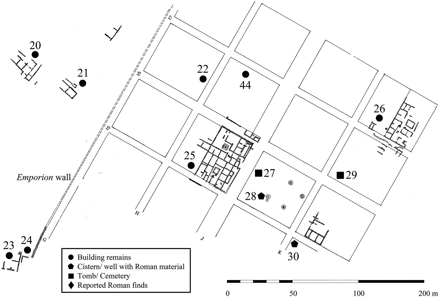
Apart from the insight into the inherited landscape of the Piraeus in the Early Imperial period, the inscription from the Athenian Acropolis reveals a concerted effort to render parts of the port and harbour infrastructure operative again. It also indicates a significant degree of continuity in the topography of the harbour, and the appearance of the maritime facade and its constituent elements. Additional support for this is provided by relevant archaeological discoveries. Four of the five stoas mentioned in ancient literary sources have been tentatively identified by several scholars (Judeich Reference Judeich1931, 443–50; Eickstedt Reference Eickstedt1991, 62–8; Steinhauer Reference Steinhauer, Malikouti and Tsokopoulos2000, 83–5; Reference Steinhauer, Greco and Lombardo2007, 199–201; Reference Steinhauer, Vassilopoulou and Katsarou-Τziveleki2009); however, owing to the restricted size of the excavated plots, the building remains could be explored only to a limited extent. Furthermore, several maps of the Piraeus show numerous linear or orthogonal built features jutting out from the pre-1834 coastline (Fig. 5). These clearly belong to elements of the ancient harbour such as jetties, breakwaters and quays but, given the lack of detailed systematic data for these features, their date and exact functions remain unclear, with the result that little can be said about their use during the Roman period.
Central part of the Kantharos harbour and emporion with building remains of Classical–Roman date (adapted from Steinhauer Reference Steinhauer, Malikouti and Tsokopoulos2000, 85; for site numbers, see Table 1).

For the purposes of the present discussion, it is more fruitful to concentrate on the reported evidence for Roman activity in the area of the Kantharos (Steinhauer Reference Steinhauer, Greco and Lombardo2007, 197–9; Reference Steinhauer, Vassilopoulou and Katsarou-Τziveleki2009; Grigoropoulos and Tsaravopoulos Reference Grigoropoulos, Tsaravopoulos, Chankowski and Karvonis2012, 277–80). Four of the sites identified as the remains of the harbour stoas have produced evidence for building and repairs in the Roman period, though, it should be noted, more precise dating of the respective building phases is generally lacking. In 1976 the remains of two parallel walls, surviving to a length of 9 m and 6 m respectively, were discovered at the junction of Charilaou Trikoupi and Notara Street, close to the site, where in 1886 excavation had uncovered the upper courses of the foundations of a stoa built in ashlar masonry and dated to the later part of the fifth century bc (Figs. 4 and 5 nos 23 and 24; Dragatsis Reference Dragatsis1886, 82–4; Alexandri Reference Alexandri1984a, 48–9 plan 7. Cf. Steinhauer Reference Steinhauer, Vassilopoulou and Katsarou-Τziveleki2009, 483). For the north wall, which abuts the upper foundation courses of the Classical building on its east, two different masonry techniques in dressed poros blocks and rubble with brick are reported, suggesting building phases of Roman date. The southern wall is built in brick and rubble with mortar bonding and shows ample redeployment of old stonework, similar to Late Roman buildings elsewhere in the town (Grigoropoulos Reference Grigoropoulos2005, 270–1), suggesting perhaps a construction date in the later third or fourth century ad. The walls attest to repeated repairs of this stoa in the Imperial period and in Late Antiquity.
To the north-east of the remains of the southern stoa, the site at 70 Philonos Street (Figs. 4 and 5 no. 17) has been identified as the second stoa of the harbour. Excavations here have uncovered extensive remains of a multi-space building that, based on numismatic evidence, appears to have remained in use until the sixth century ad (Steinhauer Reference Steinhauer1989b, 44; Grigoropoulos Reference Grigoropoulos2005, 64). The south part of this building consists of a row of at least four square spaces, which in the west connects at a right angle to another row of two spaces with a wide corridor. The exact function of this complex is not known but a residential or commercial use seems likely. The walls of the north-western flank of this building rest on an earlier wall, running north–south and surviving to a length of 13 m, which has been interpreted as belonging to the rear wall of a harbour stoa of Classical date. The available report does not make explicit reference to evidence for the use of the wall in the Roman period but this feature is aligned with a 4 m × 3.60 m near-square foundation of Early Roman date, which was discovered c.9 m to the south, underneath the remains of the Late Roman building. The aligned position of this feature with respect to the Classical wall suggests that the latter was still in use in the Imperial period. The near-square foundation has been interpreted as the substructure for the base of a colossal statue of Hadrian, which was found nearby (see below).
Remains associated with a third stoa, which have also been associated with repairs in the Roman period, are located further to the north, close to the modern quayside at the junction of Akti Miaouli Street and Bouboulinas Street (Figs. 4 and 5 no. 8). Excavations here uncovered part of the substructure of a Classical wall, comparable in construction style and block size to the foundations of the southern harbour stoa. These remains were partly built over by a 2.20 m high and 8 m long wall of massive construction dated to the Roman period, which may belong to a harbour pier (Steinhauer Reference Steinhauer1989c, 29). The remains lie very close to the (now land-filled) ancient seafront and to the north-east of the spur identified with the main loading jetty (διάζευγμα) and close to the remains of moles and the quayside. Repairs of ‘Late Roman’ date have also been reported from the remains of a large Classical building at the junction of Philonos Street and Defteras Merarchias Street (Fig. 4 and 5 no. 18; Dragatsis Reference Dragatsis1911, 147–51, fig. 1). The building was originally interpreted as belonging to one of the five stoas, though its placement further from the seafront suggests that it may have had some other function (Steinhauer Reference Steinhauer, Malikouti and Tsokopoulos2000, 88).
In his brief discussion of the Piraeus, Pausanias (1.3.14) mentions a makra stoa, which is also known from Classical sources as the site of the flour market. This building has now been identified on the north shore of the Kantharos and extensive evidence of Roman period activity has been associated with it (Fig. 4 and Fig. 5, no. 47; Steinhauer Reference Steinhauer, Malikouti and Tsokopoulos2000, 84–5; Reference Steinhauer, Greco and Lombardo2007, 201 n. 42; Reference Steinhauer, Vassilopoulou and Katsarou-Τziveleki2009, 484). According to the preliminary report (Petritaki Reference Petritaki2014d), the remains include part of the rear row of a building running east–west with a surviving length of 27.20 m, consisting of eight rooms fronted by a continuous colonnade that was placed at a distance of 3.90 m from them. The stylobate of this last feature was rebuilt in the Roman period, while the floor levels in the interior of some rooms show two distinct Roman phases. The reported pottery and small finds do not give a clear indication about the use of the building, which nevertheless is likely to have continued to be connected with the storage and redistribution of foodstuffs and grain. Despite its functional character, the makra stoa was a monumental building with an original length estimated at c.200 m (Steinhauer Reference Steinhauer, Vassilopoulou and Katsarou-Τziveleki2009, 484) and must have dominated the northern shore of the Kantharos. At this point it is important to note that immediately to the east of the stoa, on Philonos Street, the base of an honorific statue of Tiberius Claudius Bradua, the son of the Athenian magnate Herodes Atticus, was discovered in the late nineteenth century (Lolling Reference Lolling1881, 310–11; Judeich Reference Judeich1931, 449 with n. 2).
Despite the lack of detailed information for the specific function and dating of the features discussed above, the volume and density of building activity of Imperial and Late Roman date that has been documented in the area around the Kantharos demonstrates that, after the Sullan destruction, this area was redeveloped as the main harbour of the Piraeus. From the present evidence it would appear that the harbour experienced multiple phases of development to its infrastructure and remained operative from the first decades following the Sullan destruction right down to (at least) the sixth century ad. A striking feature of the evidence is that these developments do not seem to have altered the inherited features of the port, but were rather aimed at their refurbishment. The harbour facilities and stoas in the area of the emporion generally adhered to the alignment of pre-existing buildings of Classical and Hellenistic date and were frequently constructed from reused materials from these earlier buildings. As the Augustan inscription from the Athenian Acropolis indicates, this development was not coincidental. Rather, it reflects the conscious decision by the Athenian authorities in the Early Imperial period to ensure the functionality of the harbour without significantly altering its pre-existing layout and the architectural form and fabric of its features.
THE EMPORION AND THE INTERFACE WITH THE URBAN AREA
In the fifth and fourth century bc, the emporion constituted a distinct zone for trade (for both imports to, and exports from, Athens) and commercial transactions which was demarcated as a public space by boundary markers and lay under the direct control of Athenian state officers (Garland Reference Garland1987, 152–3; Eickstedt Reference Eickstedt1991, 188 (site no. I.134); Steinhauer Reference Steinhauer, Malikouti and Tsokopoulos2000, 83–5; Reference Steinhauer, Greco and Lombardo2007, 199–200; Reference Steinhauer, Vassilopoulou and Katsarou-Τziveleki2009). Traces of a massive wall dated to the Classical period discovered in three successive plots close to the southernmost stoa running north-east–south-west to a surviving total length of approximately 30 m suggest that the zone was also physically separated from the rest of the urban area (Judeich Reference Judeich1931, 447; Steinhauer Reference Steinhauer, Greco and Lombardo2007, 199–200; Reference Steinhauer, Vassilopoulou and Katsarou-Τziveleki2009, 486). It is possible that this physical distinction continued to exist into the Imperial age and became defunct only in the fourth century ad. This is indicated by the fact that the notional projection of the emporion wall to the north-east is interrupted by the remains of a large bathhouse excavated in two neighbouring plots at 118 Kolokotroni Street and 110–12 Notara Street (Figs. 4 and 5 nos 18 and 19) (Eickstedt Reference Eickstedt1991, 172, site nos 1.112 and 1.77). The part of the bathhouse discovered on the Notara Street plot continues underneath the unexcavated modern street further to the west, beyond the projected line of the boundary wall, suggesting that the building was constructed at a time when the enclosure wall of the emporion was no longer in use (Grigoropoulos and Tsaravopoulos Reference Grigoropoulos, Tsaravopoulos, Chankowski and Karvonis2012, 277–8 with n. 8). According to the available preliminary report, the bathhouse was built in the fourth century ad with a further architectural phase of later fifth century ad date (Kranioti Reference Kranioti1987, 63; Steinhauer Reference Steinhauer1988a), which provides the earliest chronological limit for the wall's disuse. The expediency of maintaining such a separation should be seen in the context of the ongoing function of the Kantharos as a commercial harbour that necessitated the control of trading activities for the purposes of levying customs duties and taxes.
Apart from the harbour stoas (see above), the remains of several multiroom buildings of Roman date have been reported from the area of the emporion. Excavated remains from a plot on 86 Philonos Street (Figs. 4 and 5 no. 20) consisted of a complex of at least six spaces, arranged in two rows, with two rectangular spaces running north-east–south-west and three further spaces, connected by doorways, bordering from the north-west (Alexandri Reference Alexandri1983a; Eickstedt Reference Eickstedt1991, 190, site no. I.144). Aligned to the latter row were another two spaces, one of which had an entrance from the east. The complex, from which coins of c.500 ad have been reported, has been dated to the Late Roman period, although several remains of walls suggest earlier (Roman?) activity in the area. Another site with evidence of multiple phases of building activity dated to the Roman Imperial and Late Antique periods was discovered about 50 m east of this plot at 131 Philonos Street (Figs. 4 and 5 no. 21; Alexandri Reference Alexandri1983b; Eickstedt Reference Eickstedt1991, 191 site no. 1.146). The remains consisted of a row of rectangular spaces connected by a doorway and facing north-east. At a 2 m distance from these spaces lay a (later) wall running parallel for c.7.5 m and forming a wide corridor. To the south, further walls and wellheads of cisterns were discovered. It is of significance that several walls in both plots share the same alignment towards the harbour and show similarities in construction technique and wall thickness (0.50–0.66 m). Given these similarities and the proximity of the plots to one another, it cannot be ruled out that these remains belonged to a single complex.
Traces of walls comparable in terms of building techniques and appearance to the aforementioned have been reported at several other sites on the eastern shore of the Kantharos, along Philonos Street (Figs. 4 and 5 nos 12 and 16; Eickstedt Reference Eickstedt1991, 190–1 site nos 1.141 and 1.145). It is to be noted that these walls form spaces that appear to be aligned to the harbour stoas and, along with the similarities noted above, may indicate the presence of buildings or larger complexes. Due to the lack of detailed published information, the function of these multiphase remains is unclear, although it has been suggested that in some cases they might have been used as storage facilities (Steinhauer Reference Steinhauer, Greco and Lombardo2007; Reference Steinhauer, Vassilopoulou and Katsarou-Τziveleki2009, 483). Definitive evidence comes from a recently investigated extensive building complex, 117 m in length, that included several rooms with large storage jars (Figs. 4 and 5 no. 46; Petritaki Reference Petritaki2014b). This complex lies very close to remains of Late Roman harbour jetties (Figs. 4 and 5 no. 8) and its main phase has been dated to the fourth/fifth century ad. The existence of Early Imperial-period warehouses for the storage of bulk commodities is now confirmed by a fragment of an inscription, in Greek, dated to the period between the second half of the first century bc and the first half of the first century ad (Grigoropoulos and Tsaravopoulos Reference Grigoropoulos, Tsaravopoulos, Chankowski and Karvonis2012, 297–8). The inscription, whose purpose may have been to honour a person who provided funds for the construction or repairs of buildings, makes reference to a large warehouse ([ἀπο]θήκης μεγ[άλης]) and a set of other (perhaps smaller) warehouses. The fragment was discovered at the ‘Dikastiko Megaro’ site (Figs. 4 and 5 no. 25; Fig. 6), a few metres to the east of the emporion and may refer to specific buildings in that area.
Classical–Early Roman street grid, domestic/utilitarian buildings and emporion wall to the east of the Kantharos (adapted from Steinhauer Reference Steinhauer, Malikouti and Tsokopoulos2000; for site numbers, see Table 1).

Due to the limitations and the random nature of urban rescue excavation, little can be said with certainty about how the harbour was integrated into the rest of the urban area of the port during the Roman period. The actual interface is difficult to reconstruct but the possible presence of a boundary wall surrounding the Kantharos in the Imperial period is significant (see above), as it indicates the existence of gates at the entrances to the harbour that facilitated access into and out of the emporion. On analogy with other Roman ports in the Aegean, where such gateways connected the port to the rest of the urban area and provided access to stoas, market squares or grander complexes (Bouras Reference Bouras, Chankowski and Karvonis2012), it is reasonable to suggest that the harbour gates connected the emporion to major roads leading to Athens and/or lay close to prominent urban monuments. While Pausanias (1.1.3) mentions the existence of two agorai in the Piraeus during his time, actual physical evidence of these is currently lacking (Hoepfner and Schwandner Reference Hoepfner and Schwandner1994, 43 and Steinhauer Reference Steinhauer, Hoepfner and Schwandner1994a, 49; Hoepfner Reference Hoepfner, Hoepfner and Lehman2006, 19–20; Grigoropoulos and Tsaravopoulos Reference Grigoropoulos, Tsaravopoulos, Chankowski and Karvonis2012, 279 with n. 17–18). The so-called Hippodamian agora, whose gate according to the building inscription of Philo's arsenal lay close to the latter (IG II2 1668, lines 5–6; see also SIG 3 , 969), was the civic centre of the deme since the Classical period, while the ‘agora for those close to the sea’ (Pausanias, 1.1.3) was close to the makra stoa in the northern part of the emporion (see above). It is possible that the precinct of Zeus Soter and Athena, which according to Pausanias (1.1.3) also continued to exist into the Imperial period, lay between the Hippodamian agora and the makra stoa of the emporion (Garland Reference Garland1987, 152–3).
Despite the extensive damages in 86 bc, the post-Sullan and Imperial redevelopment of the Piraeus did not involve a radical redesign of the emporion or the urban area but was based firmly on a conscious redeployment of the inherited features of the pre-Sullan port. The same observation can be made for the urban/residential area of the isthmus immediately to the east of the emporion, where the orthogonal street grid, first laid out in Classical times, was retained during the Imperial period (Grigoropoulos Reference Grigoropoulos2005, 111–13; Steinhauer Reference Steinhauer, Greco and Lombardo2007). The Imperial-period building activity took place within the bounds of the pre-existing plots, while signs of building encroachment on the streets appear only from the later third/early fourth century ad onward (Grigoropoulos and Tsaravopoulos Reference Grigoropoulos, Tsaravopoulos, Chankowski and Karvonis2012, 283–4) (Fig. 6). Interestingly, from the present evidence, it appears that the physical distinction between the emporion, where buildings were laid out with respect to the harbour shore, and the rest of the urban area, where plots conformed to the planned street grid, was maintained until late in the Imperial period.
THE ZEA AND MOUNICHIA HARBOURS: ABANDONMENT, PERSISTENCE OR REDEVELOPMENT?
In contrast to the activity attested for the Kantharos harbour and the emporion throughout the Roman period, the picture gained from the available evidence for the condition and use of the two smaller harbours is more erratic and suggests a range of responses. The two harbours were in pre-Roman times the chief locations of the Athenian naval base and their infrastructure must have suffered extensive damage during the Sullan sack, as suggested by ancient literary sources, and supported in certain cases by archaeological discoveries (see above). As concerns the Zea harbour, the reference to neoria in the Augustan inscription from the Athenian Acropolis (IG II2 1035, line 43) is suggestive of the persistence of some facilities in this area into the Early Imperial period (Day Reference Day1942, 144–5). It is not clear, however, if these facilities were slipways or shipsheds, nor can it be gleaned from the text whether they actually functioned or not. Recent underwater investigations in the Zea harbour by the Zea Harbour Project have registered no features of Roman date and a near-total absence of relevant finds (Løvén and Schaldemose Reference Løvén and Schaldemose2011, 39–40). It is interesting to note that the site of Philon's arsenal has yielded evidence for extensive plunder of stones during the early fourth century ad (Steinhauer Reference Steinhauer, Hoepfner and Schwandner1994a, 49), which indicates that, following its destruction in 86 bc, the building remained in a ruinous state for a considerable length of time and was eventually used as a quarry.
All these strands of evidence seem to suggest that the Zea harbour ceased to fulfil naval military functions during the Roman period and that several parts of the harbour front were abandoned or redeveloped for different purposes. This conclusion is reinforced by the results from an old excavation on the western shore of the Zea harbour, c.100 m to the south of the Late Hellenistic theatre (Fig. 4 no. 32; Dragatsis Reference Dragatsis1892). This excavation brought to light part of an extensive building, constructed of brick and with numerous spaces arranged around a court with a central pool, water pipes and an entrance with a mosaic floor (Fig. 7), which has been dated on stylistic grounds to the second century ad (Waywell Reference Waywell1979, 302). The building was initially interpreted as a bath complex (cf. Day Reference Day1942, 143) but the ground plan and absence of bathing facilities rather suggest a well-appointed urban villa (Kahrstedt Reference Kahrstedt1954, 49–50). It was constructed on top of the remains of Classical shipsheds, suggesting that by that time these features had fallen out of use and the area had been partly filled up. This example demonstrates that patterns of land use in this part of the port, which in the pre-Sullan era lay under direct state control, had changed. It also serves to illustrate the reasons that necessitated an official response by the civic authorities during the Augustan period against the alienation of public land (see above).
Early Roman urban villa near the Zea harbour (after Dragatsis Reference Dragatsis1892).

The evidence concerning the harbour of Mounichia is more puzzling. Despite the evidence for a few Roman rock-cut tombs on the western slopes of the hill overlooking the harbour (Fig. 4 no. 11; Steinhauer Reference Steinhauer1989d, 26), the sanctuaries of Artemis Mounichia on the south promontory and that of Asklepios on the southwest (Fig. 4 nos 38 and 39) seem to have been refurbished following the Sullan sack, and several finds and votives indicate cult continuity into the Roman Imperial period (Palaiokrassa Reference Palaiokrassa1991, 43; Eickstedt Reference Eickstedt2001). Apart from its naval function, the harbour in the Classical and Hellenistic periods was used for the training of young Athenian citizens (ephebes), which involved rowing exercises from the sanctuary of Artemis around the Akte to the Kantharos. An ephebic list dated to 192/3 ad (IG II2 2130, line 49; Garland Reference Garland1987, 113–14 and 230 no. 21) mentions a ‘battle at sea’ (ναυμαχία) off Mounichia, which indicates that docking infrastructure and possibly storage sheds for the boats may have existed there at that time. More recently, the remains of four shipsheds dating to the fifth century bc showing evidence for extensive rebuilding in both the fourth century bc and in the Roman period have been reported on the northern shore of the Mounichia harbour (Fig. 4 no. 40; Petritaki Reference Petritaki2010c, 443–4 with fig. 1). During the post-Sullan/Roman phase, the three colonnades to the north underwent extension, while a published photograph (Petritaki Reference Petritaki2010c, fig. 1) also shows an apsidal structure near the northern end of the plot. The surviving length of these colonnades (30.2 m) suggests a building of considerable size; it is, however, not yet clear whether the remains of this last phase, which has not yet been dated with more precision, belong to actual shipsheds or a building of a different function.
IMPERIAL REPRESENTATION AT THE PORT
Considering the overwhelming evidence for refurbishments to the Kantharos, it is perhaps no coincidence that the harbour and the area of the emporion also took on a monumental and politically significant character. The deigma retained its traditional role as prime location for displaying public documents. An example of this is a Hadrianic rescript concerning the regulation of fish sales during the Eleusinian Mysteries (IG II2 1103), which explicitly stated that the document must be set up in that location and was discovered close to the southernmost stoa of the emporion (Steinhauer Reference Steinhauer, Vassilopoulou and Katsarou-Τziveleki2009, 485; IG II2 1103, lines 10–11). In addition, during the Hellenistic period, statues of foreign rulers who had financed the grain supply of Athens were set up in the emporion (Judeich Reference Judeich1931, 449; Garland Reference Garland1987, 153). This precedent also appears to have been followed in the Early Imperial period, with the waterfront becoming a showcase of images of members of the Imperial house, as well as the local and provincial aristocracy.
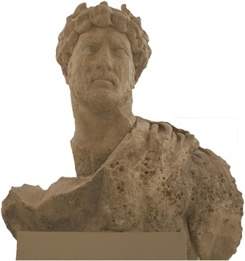
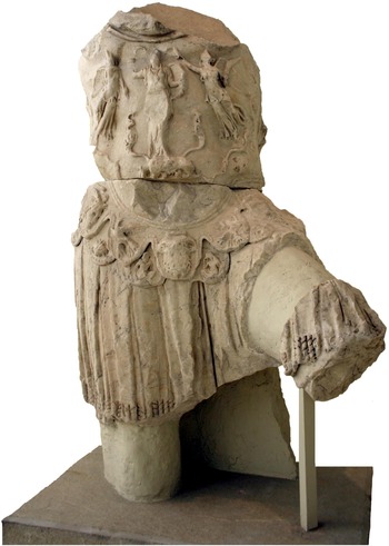
No less than five such statues and portraits are known from the area of the Kantharos. Several of these were reportedly dredged up from the seabed near the eastern shore of the harbour in the early twentieth century, while others were discovered during more recent rescue excavations close to the waterfront. They include images of Claudius and Trajan (Toynbee Reference Toynbee1958/9, 285 n. 1; Steinhauer Reference Steinhauer1998, 90–1), two colossal cuirassed statues of Hadrian (Figs. 8 and 9; Kallipolitis Reference Kallipolitis1966, 69; Zoridis Reference Zoridis1982; Bergmann Reference Bergmann2010, 220–7), and a larger than life-size statue of Balbinus in the guise of Zeus (Schlieffen Reference Schlieffen1935; Toynbee Reference Toynbee1958/9, 285 n. 1). A base of a similarly sized statue with an eagle at its feet has been regarded as a representation of either emperor Balbinus or his co-emperor Pupienus, and there is also a cuirassed bust of a young male which has been dated to the mid-first century ad (Toynbee Reference Toynbee1958/9, 286–8, pl. 68). Additionally, a statue base for the son of the Athenian magnate Herodes Atticus of Marathon, set up by a group styling themselves as the ‘citizens resident in the Piraeus’, is also known from the north part of the Kantharos (IG II2 3978; Lolling Reference Lolling1881, 309–10).
Colossal statue of Hadrian (Piraeus Museum Inv. 1197. Copyright Hellenic Ministry of Culture, Education and Religious Affairs, N3028/ 2002).

Torso and leg from a colossal cuirassed statue of Hadrian (Piraeus Museum Inv. 8097. Copyright Hellenic Ministry of Culture, Education and Religious Affairs, N3028/ 2002).

As contextual information for the old finds is completely lacking, it is unfortunately impossible to verify, in every case, the precise locations along the harbour's waterfront where these portraits or statue bases were discovered, let alone where they might have stood. Several of these portraits bear traces of wear attributed to deposition in the sea, and scholars in the past have suggested that the images either were set up in front of the harbour stoas or, alternatively, were artworks of Athenian sculptors destined for shipment overseas (Vermeule Reference Vermeule1968, 259; Zoridis Reference Zoridis1982, 121; Steinhauer Reference Steinhauer1998, 91). The latter explanation is not convincing because none of the portraits were apparently discovered in an assemblage together with other sculptural works that could suggest a workshop's cache or a ship's cargo. In fact, the fragments of the headless cuirassed torso of Hadrian crushing a barbarian were discovered near the site identified as the middle harbour stoa (Figs. 4 and 5 no. 17; Steinhauer Reference Steinhauer1989b, 44 with fig. 1). The torso clearly belongs to a colossal statue that originally may have measured between 3.50 m and 3.80 m in height (Bergmann Reference Bergmann2010, 261–2; P. Karanastassi, pers. comm.). Close to its findspot, excavation brought to light a massive square foundation of poros blocks measuring 4 m × 3.60 m, which has been interpreted as the substructure of the socle for a colossal statue or an associated architectural monument (Steinhauer Reference Steinhauer, Malikouti and Tsokopoulos2000, 37). The existence of this feature close to the place where Hadrian's headless torso was discovered is a strong indication that imperial statuary was on display at the harbour.
Both pictorial representations and literary references suggest that the shorelines of many Roman ports were dominated by statues of emperors. Moreover, the occurrence of two colossal statues among the imperial portraits discovered in the emporion is significant. Colossal images of emperors were a common feature of Roman ports in both Italy and the provinces, where they related directly to elements of the harbour topography, as did the statue of Trajan in front of the temple of Liber Pater at Portus and the colossal statues of Augustus and Roma at the harbour of Caesarea Maritima (Sear Reference Sear1982, 125; Kahn Reference Kahn, Raban and Holum1996). The size and prominent placement of such statuary could not escape the eyes of passengers on ships sailing into the harbour, as suggested in the famous comment by Arrian of Nicomedia that Hadrian's statue at the port of Trapezous was a bad resemblance of the emperor but ‘successful in its posture – facing the sea’ (Periplus of the Euxine Sea 1.1–4, trans. N. Hannestad, cited in Hannestad Reference Hannestad1986, 201). Given the prominence of harbours as locales of imperial propaganda (Tuck Reference Tuck1997), the display of imperial statues in the emporion sought to underscore the port's function as a node of communication within a unified realm.
ECONOMIC PERFORMANCE AND MARITIME FUNCTIONS
Attica boasted numerous natural harbours and coastal locations where ships or boats could moor. Various archaeological discoveries suggest that several of the rural demes on the western and eastern coasts were serviced by individual ports into the Roman period (Petropoulakou and Pentazos Reference Petropoulakou and Pentazos1973, fig. 28; Vermeule Reference Vermeule1962; Reference Vermeule1976, 73–4). However, its proximity to the city and the size and suitability of the Kantharos for commercial operations made the Piraeus the port of Athens par excellence. The main roads connecting the port to the asty were in place for centuries (Steinhauer Reference Steinhauer, Malikouti and Tsokopoulos2000, 111; Petritaki Reference Petritaki, Vassilopoulou and Katsarou-Τziveleki2009a, 463–5 and 470) and ensured that goods could reach swiftly the city markets and further inland, while at the same time enabling the overseas export of regional products. Not least, by the first century bc, the city was becoming a destination for travellers from east and west and therefore increasingly dependent on the revenue and benefactions generated by this maritime traffic (Woolf Reference Woolf and Alcock1997, 8–12).
M. Hoff (Reference Hoff, Hoff and Rotroff1997; Reference Hoff and Cathaway2002; Reference Hoff, De Blois, Bons, Kessels and Schenkeveld2005) has noted the significance of Pompeius Magnus’ donations for the deigma in the 60s bc as an early attempt at helping to re-establish the impoverished city's commercial infrastructures and reaffirm its openness to trade. This importance is further indicated by the evidence for the persistence and/or re-establishment of a number of Athenian magistracies whose sphere of activities related to the port's and city's markets, commerce and food supply in the Early Imperial period. The office of the agoranomos (albeit now including just one person as opposed to the five agoranomoi of the port in the Classical period: Garland Reference Garland1987, 77, 195–6) is attested from a price list of meat cuts, which was carved twice, first shortly before the sack of the port in 86 bc and once more around 25 bc (SEG XLVII 196B; Steinhauer Reference Steinhauer1994b; Schmalz Reference Schmalz2009, 9–10). The inscription was discovered in a residential block with commercial spaces and suggests that the officer was also responsible for the markets and retail activities in the urban area of the port (Grigoropoulos and Tsaravopoulos Reference Grigoropoulos, Tsaravopoulos, Chankowski and Karvonis2012, 293–4; Descat Reference Descat, Capdetrey and Hasenohr2012). Other epigraphic evidence indicates that his sphere of activity probably extended to the commercial operations in the emporion (IG II2 1035, lines 47–8). Another civic officer referred to as epimeletes (curator) of the Piraeus was (on analogy with the office of the Classical period: Garland Reference Garland1987, 79, 196) probably responsible for the administration of the emporion (IG II2 3268; Geagan Reference Geagan1967, 119–20). In addition to the offices explicitly concerned with the Piraeus, it is likely that several other civic magistrates were involved in ensuring the smooth operation of the port. The most important was arguably the hoplite general, whose chief responsibility, as in the Classical and Hellenistic periods, was the city's food supply but may have also included the administration of shipping (Geagan Reference Geagan1967, 21–3).
As in the previous centuries (Garnsey Reference Garnsey, Garnsey and Scheidel1998), securing enough food for the urban population must have been the chief concern faced by Athenian civic magistrates in the Roman period. The city not only had to import large quantities of grain, but also suffered frequently by severe shortages leading to civil unrest, a fact that from early on induced the intervention of imperial authorities (Day Reference Day1942, 209–10). This took a number of forms, including grants of grain-producing islands and overseas territories, and did not affect only grain but also involved direct state purchase of olive oil crops, as related in the Hadrianic law displayed in the Roman agora at Athens (IG II2 1110; Day Reference Day1942, 189–92; Harter-Uibopuu Reference Harter-Uibopuu, Alston and Nijf2008). Another Hadrianic rescript relates specifically to the function of the fish port and the fishmongers in the Piraeus (IG II2 1103; Day Reference Day1942, 192–3). The most extravagant, however, was the introduction of annual grain distributions by Hadrian (Dio Cassius, 69.16.2; Boatwright Reference Boatwright2000, 92, n. 41). This exceptional measure for a middle-sized provincial city (unparalleled outside Rome, with the possible exception of Antioch; De Giorgi Reference De Giorgi, Alston and Nijf2008, 77) underscores the importance attached to Athens by the emperor and has been linked to the city's enhanced role as the seat of the Panhellenion after 131/2 ad (Spawforth and Walker Reference Spawforth and Walker1985, 90). The specifics of this supply mechanism are not known but since the grain came from overseas, the harbour facilities and warehouses must have played key operational and logistical roles. If this was so, the emperor's statues erected at the harbour and the honours Hadrian received as ktistes in the port (IG II2 3373; Bergmann Reference Bergmann2010, 248–58) may also be understood within this context of the grain supply (Zuiderhoek Reference Zuiderhoek, Alston and Nijf2008, 177).
Grain must have been only part of the range of goods and commodities that arrived at the port from overseas. Indeed, the incoming grain trade may have indirectly promoted the establishment of various other lines of commercial operations, as suggested by the story of the philosopher Proclus of Naucratis, who lived in the second century ad. Philostratus (Lives of Sophists, 603) writes that Proclus owned houses in the Piraeus and Athens from which he coordinated an import business of luxury commodities from Egypt. Literary sources, similarly, contain various strands of information about the export of agricultural products from Athens and Attica (Day Reference Day1942, 202–12), while exports of certain classes of non-agricultural products, raw materials and manufactured goods, such as Pentelic marble and lamps, are also evidenced by relevant archaeological discoveries in several parts of the empire (Spawforth and Walker Reference Spawforth and Walker1986, 101; Kane, Donato and Carrier Reference Kane, Donato, Carrier and Luni2010; Herrmann Reference Herrmann and Jockey2011). Due to the lack of detailed data from excavated sites, however, it is impossible to examine how bulk commodities were handled in the port, how such products were stored and what quantities might have been involved. Pottery assemblages provide an index of the range and relative quantities of ceramic wares that reached the Piraeus over the Roman period (Grigoropoulos Reference Grigoropoulos2005, 207–45; Reference Grigoropoulos, Papanikola-Bakirtzi and Kousoulakou2010), but as these come from domestic sites, they are more informative about supply and local consumption than about the logistical aspects of commercial operations. A residential block excavated in the urban area of the port has furnished architectural evidence and finds that clearly indicate commercial activities during the Imperial and Late Roman periods; these, however, appear to have been of a retail nature (Fig. 6 no. 25), including the sale of food and drink during the last phase of occupation, and do not seem to have required large storage capacities (Grigoropoulos and Tsaravopoulos Reference Grigoropoulos, Tsaravopoulos, Chankowski and Karvonis2012, 280–93).
The clearest evidence for export activity through the port comes from the accidental underwater discovery of a large group of decorative marble relief panels and a few other works of sculpture (Strocka Reference Strocka1967, 39–40; Stephanidou-Tiveriou Reference Stephanidou-Tiveriou1979). The assemblage was recovered from the sea bottom at a depth of 4 m to 4.50 m in the north-eastern cove of the Kantharos close to the stone wall of an ancient mole that had collapsed. The findspot and traces of burning on the sculptures suggest that these were the cargo of a ship that caught fire and sank in the harbour. The panels (all of Pentelic marble), several of which have the same subject, demonstrate remarkable stylistic and technical similarities, suggesting that the group was the product of a single workshop of the early Antonine period. The size of the original consignment has been estimated as roughly double that of the recovered fragments. A similar relief panel found in Rome is attributed to the same workshop and it has been suggested that the panels found in the Piraeus were part of a shipment destined for Roman metropolitan consumption (Stephanidou-Tiveriou Reference Stephanidou-Tiveriou1979, 51, n. 10). It is probable, then, that the marble workshop responsible for these sculptures was established and operated in the port specifically for the export market.
The commercial operations in the Piraeus generated ample opportunities for business and, as the story of Proclus (see above) makes clear, attracted individuals of diverse ethnic and social backgrounds. As expected in a port, the evidence of tombstones with recorded ethnics discovered from the Piraeus and its environs demonstrates a strong presence of foreigners, including persons of both Athenian civic status from elsewhere in Attica and individuals from other regions of the eastern empire (Grigoropoulos Reference Grigoropoulos2009). Further epigraphic evidence demonstrates the activity of imperial slaves, as shown by the inscription on a marble throne first documented by J. Stuart and N. Revett (Reference Stuart and Revett1825, 20 with Pl. II fig. 2; CIL III 556) (Fig. 10). The throne appears to be an older monument, reminiscent of the honorific seats erected in Classical and Early Hellenistic theatres, that had been reworked and furnished with a funerary dedication in Latin in the early second century ad (Oliver Reference Oliver1941, 246; Maass Reference Μaass1972, esp. 101–2 with pl. IIIb; Weaver Reference Weaver1964, 139; Reference Weaver1965; Reference Weaver1968, 121–2; Reference Weaver1972, 75–8). The dedication is made by a certain Sagaris, who styles himself as deputy (vicarius) to Alcimus, imperial slave and cashier (arcarius) of the procurator of the province of Achaia. The presence of members of the procurator's staff at ports is attested from other provinces, and it has been argued that the role of such persons of slave status frequently masked their involvement in the management of their masters’ estates or business enterprises (Weaver Reference Weaver1972, 202–4).
Funerary monument of Q. Turranius Maximus (after Stuart and Revett Reference Stuart and Revett1825, pl. II fig. 2).

To the primary function of the Piraeus as a merchant port, one should add the use of the harbour as a station for military operations of the imperial fleet. This case has been made by several scholars in the past on the basis of a number of Latin tombstones that were discovered in Athens (the Athenian Agora and the Kerameikos), the Piraeus and Eleusis (Oliver Reference Oliver1941, 244–9; Reference Oliver1942, 90; Kienast Reference Kienast1966, 122; Reddé Reference Reddé1986, 227–30). The tombstones mostly commemorate members of the fleets of Misenum and Ravenna, as well as soldiers of several legions and army units, including the IX Claudia Pia Fidelis, the X Gemina and the cohors III Campestris, including M. Valerius Capito, who served as nauphylax (? ship's guard or supervisor of stowage) of the Misenum fleet (Fig. 11). Oliver (Reference Oliver1941, 246) argued that all tombstones date to the same period and suggested that they commemorated soldiers who died while stationed in the Piraeus on their way to the Parthian frontier sometime between 113 and 120 ad.
Tombstone of M. Valerius Capito (Piraeus Museum Inv. 1645; after Moock Reference Moock1998, pl. 68c. Copyright Hellenic Ministry of Culture, Education and Religious Affairs, N3028/ 2002).

More recently, it has been argued that these soldiers may have become involved in the completion of aqueduct building projects in Athens and Eleusis in the early years of Hadrian's reign (Lancaster Reference Lancaster2010, 466). Traces of an aqueduct attributed to Hadrian's refurbishment of Athens’ water supply have also been discovered in several rescue excavations in the northern outskirts of the Piraeus (Fig. 4 nos 1 and 7; Lolos Reference Lolos1997, 305; Grigoropoulos Reference Grigoropoulos2005, 99–102; Petritaki Reference Petritaki2002c; Petritaki Reference Petritaki, Vassilopoulou and Katsarou-Τziveleki2009a, 470, site nos 54 and 91), including reused parts of the Classical Long Walls (Liangouras and Papachristodoulou Reference Liangouras and Papachristodoulou1972, 344 b. 7; Conwell Reference Conwell1992, 538–40). The possible association between the stationing of military units in the port and aqueduct construction merits further examination, when more evidence about the actual date and construction details of the excavated remains becomes available. At any rate, Kienast (Reference Kienast1966, 122) and Reddé (Reference Reddé1986, 229) have argued that this presence was not a circumstantial event but goes back to the Julio-Claudian period and reflects the regular function of the Piraeus as a relay station of the Italian fleet. This may also explain Pausanias’ reference (1.1.2) to the existence of shipsheds (νεὼς οἶκοι) in the port in his time.
These observations draw attention to the multifaceted role and functions of the Piraeus during the Imperial period and highlight its position in the context of Athens, Attica and the province of Achaea. The importance of the Piraeus for Roman Athens cannot be overstated (Day Reference Day1942, 151). The port was the main maritime gateway of Athens and Attica, through which regional products and manufactured goods were exported in bulk to overseas markets, and imported staples, commodities and luxuries from across the empire reached the urban population in the city. Its smooth functioning hence directly related to the survival of Athens as an urban community, and this is mirrored not least in the continued evidence for several Athenian offices associated with the grain supply and the function in the port. In addition, commercial operations in the port were important for purposes of taxation for the imperial treasury, as suggested by the presence of members of the procurator's staff. The function of the port within the context of military operations of the imperial fleet is a matter that warrants future investigation. Considering the size of the Kantharos and the suitability of its harbour basin, however, this appears to be a plausible scenario and, as will be discussed in the next section, it is also documented in later times.
THE PORT IN THE POST-HERULIAN AND LATE ROMAN PERIOD
As was the case with the Sullan sack of 86 bc, the Herulian invasion of 267 ad is traditionally taken to mark a turning point in the history of Athens (Thompson Reference Thompson1959, 62; Frantz Reference Frantz1988, 1–3). Its impact on the settlement and function of the Piraeus is however less well-known. According to some historical sources, the Heruli reached Attica by sea and local resistance at Athens involved naval operations (reportedly with the participation of the imperial fleet) to repel them (Historia Augusta 6.1; Zonaras XII, 26 C–D; Dindorf Reference Dindorf1870–1, Dexippus F 28; Millar Reference Millar1969, 26–8; Fowden Reference Fowden1988, 51 n. 14). Evidence of damage and coin hoards from some sites may be associated with this episode (Fig. 4 nos 25, 26; Grigoropoulos Reference Grigoropoulos2005, 264–5; Grigoropoulos and Tsaravopoulos Reference Grigoropoulos, Tsaravopoulos, Chankowski and Karvonis2012, 283; Axioti Reference Axioti, Vassilopoulou and Katsarou-Τziveleki2009, 493–4; Petritaki Reference Petritaki2014c), while for the late third and fourth century ad there is evidence for both renewal and abandonment.
In the course of the Late Roman period, settlement activity appears to have shifted further towards the area of the emporion, as suggested by the occurrence of Late Roman tombs to the west of the Zea theatre (Fig. 4 nos 27, 29 and 41; Alexandri Reference Alexandri1984a; Steinhauer Reference Steinhauer1989a; Steinhauer Reference Steinhauer, Hoepfner and Schwandner1994a, 49). The area of the emporion has indeed furnished extensive evidence both of repairs and of new building activity dating to as late as the sixth century ad, and must have formed the core of the Late Roman port. Significant building activity can be associated with the stoas and other utilitarian constructions near the harbour (Figs. 4 and 5 nos 20, 21, 23, 24, 46), suggesting that the commercial function of the Piraeus remained important until the sixth century ad, or even later. Importantly, foundation walls and architectural fragments discovered close to the Zea theatre (Benson Reference Benson1959, 269) appear to indicate the presence of a basilica church (Fig. 4 no. 31; Steinhauer Reference Steinhauer, Malikouti and Tsokopoulos2000, 38; Lingouri-Tolia Reference Lingouri-Tolia, Dogka-Toli and Oikonomou2013, 26). As shown by the evidence from the ‘Dikastiko Megaro’ site (Fig. 6 no. 25), the street grid from the previous centuries became gradually defunct due to increased encroachment by domestic buildings; similarly, it was probably during this period that the physical separation of the emporion from the rest of the urban area ceased (see above).
From the early years of the fourth century ad and throughout the rest of the century the port experienced significant building activity of both private and public character (Steinhauer Reference Steinhauer, Hoepfner and Schwandner1994a, 49–50). Part of a residential block with houses in the central part of the isthmus (Figs. 4, 5, 6 no. 25) was transformed in the first half of the fourth century ad into a complex of independent residential units with two storeys and extended space provided for commercial and utilitarian use on the eastern street front (Grigoropoulos and Tsaravopoulos Reference Grigoropoulos, Tsaravopoulos, Chankowski and Karvonis2012, 282–5). The construction of a second storey and the creation of additional rentable accommodation reflect speculation in urban property and indicate demand for residential space at the port (Grigoropoulos Reference Grigoropoulos2005, 268, 270–1). Further to the north-east, a large bathhouse excavated in two neighbouring plots was constructed in the fourth century ad, with a second phase of extensive repairs dated to the fifth century ad (Figs. 4 and 5 nos 18 and 19; Steinhauer Reference Steinhauer1988a; Kranioti Reference Kranioti1987; Eickstedt Reference Eickstedt1991, site nos 1.77 and 1.112). The construction of such a large building indicates the existence of a reliable water supply and suggests that the aqueduct still functioned (Gauville Reference Gauville2001, 54 n. 14; Petritaki Reference Petritaki, Vassilopoulou and Katsarou-Τziveleki2009a, 476, no. 54). Meanwhile, extensive quarrying activity and stone robbing dated to the fourth century ad has been attested at the remains of Philo's arsenal close to Zea harbour (Fig. 4 no. 41; Steinhauer Reference Steinhauer, Hoepfner and Schwandner1994a, 49), indicating that the stonework was reused for construction work elsewhere in the port.
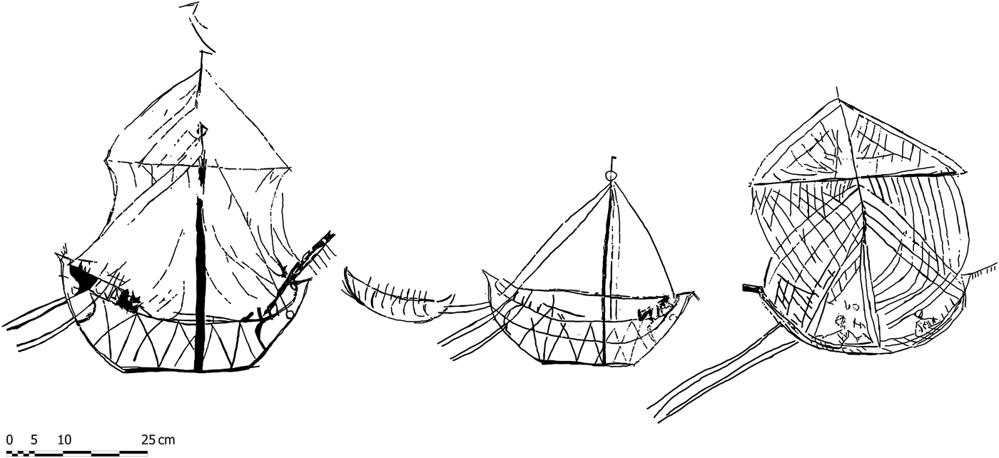
The precise reasons for these building projects are not known but it is evident that the apparent revival of the port had as much to do with the continued significance of maritime traffic and commerce for Athens as it did with broader historical developments. The nature of this traffic and the types of ship sailing into the port are suggested by a series of graffiti probably dating to the later third or fourth century ad from the walls of a cistern underneath one of the houses excavated at the ‘Dikastiko Megaro’ site (Figs. 4, 5 no. 25; Grigoropoulos and Tsaravopoulos Reference Grigoropoulos, Tsaravopoulos, Chankowski and Karvonis2012, 282–5). The graffiti show common Roman merchant vessels of different sizes with tenders, and include rudimentary details of their construction (Fig. 12; Tsaravopoulos Reference Tsaravopoulos and Tzalas1996). Apart from the commercial aspect, maritime traffic through the Piraeus ensured the steady inflow of pilgrims and students to the philosophical schools at Athens. Eunapius (Lives of the Sophists 480) describes how a captain upon arriving at the Piraeus led a group of his passengers to the house of the sophist Prohaeresius, noting that elder disciples of the various schools waited eagerly at the port to recruit new students who had just disembarked. Regular maritime transport for travellers on merchant ships existed between the Piraeus and several major ports in the eastern part of the empire, such as Alexandria and Cyrene, as suggested by various literary sources down to the late fifth century ad (Synesius, Letter 54; Dagron and Rougé Reference Dagron and Rougé1982, 117–33).
Late Roman ship graffiti (after Tsaravopoulos Reference Tsaravopoulos and Tzalas1996).

The port's role as a supply base for Athens must have also remained crucial throughout the fourth century ad. Literary sources credit Constantine and his successors with benefactions to Athens concerning the city's grain supply, including the reintroduction of a grain dole and gifts of grain-producing islands (Julian Oratio I.6, Panegyric to Constantius II). It has been suggested that the grain dole was introduced after Constantine himself was elected hoplite general in Athens, which may have taken place sometime after 317 ad (Barnes Reference Barnes1981, 72; cf. Sironen Reference Sironen and Castrén1994, 26 no. 10). It is reasonable to assume that in this capacity Constantine was directly interested in the upkeep of the harbour facilities at the Piraeus. Similar benefactions to the city's grain supply by Constantine's successors indicate that the port continued to be significant during this time, and attest to imperial involvement in its maintenance. It is also significant to note here that Athens and the Piraeus belonged to Constantine's power base in Greece during the struggle against Licinius. The port functioned as a naval station for the forces gathered by Constantine's son Flavius Julius Crispus during the winter of 324 ad, in preparation for the attack against Licinius’ fleet in the Hellespont (Barnes Reference Barnes1981, 76; Gauville Reference Gauville2001, 54). This may have been a reason behind the maintenance of the harbour facilities and the building activity in the port.
Additionally, the shift of centralised power to the eastern part of the empire must have had an impact on the function of the port in the long term. An important aspect was the redirection of a large part of maritime traffic and seaborne trade from the west to the new capital at Constantinople. In the Aegean, this impact is evident with the increase in the number of coastal sites and settlements with signs of architectural monumentalisation (e.g. public buildings, basilicae) and increased ceramic imports, especially African Red Slip Ware (ARS) which dominated the Mediterranean markets during the course of the fourth to around the mid-fifth century ad (Abadie-Reynal Reference Abadie-Reynal1989, 143–59; Bonifay Reference Bonifay2004; for Athens, see lately Hayes Reference Hayes2008, 71–2). M. Bonifay (Reference Bonifay2003; Reference Bonifay2005, 575–6) has noted that this predominance is not paralleled by high numbers of North African amphora imports, a pattern observed especially on coastal sites on the southern Greek mainland. This is also reflected in some pottery assemblages from the Piraeus, where from the first half of the fourth century and until the beginning of the fifth century ad ARS makes up between 35 and 50 per cent of the total fineware assemblage (Fig. 13 a; Grigoropoulos Reference Grigoropoulos2005, 226–31 with figs. 186–7; Reference Grigoropoulos, Papanikola-Bakirtzi and Kousoulakou2010). From the later fifth and until the mid-sixth century ad, the near-domination of the market by ARS is reversed by the influx of mass-produced red slip finewares from Asia Minor (Fig. 13 b). Here too, imports of North African amphorae commonly circulating in the rest of the Mediterranean remain low (Bonifay Reference Bonifay2004, 456), as is also the case on other Aegean and south Greek sites (e.g. at Argos: Abadie-Reynal Reference Abadie-Reynal1989, 145; Sodini Reference Sodini, Belke, Hild, Koder and Soustal2000, 195). According to Bonifay (Reference Bonifay2003), this pattern shows that ARS reached the Aegean not as an accompaniment to commodities transported in amphorae, but rather with other cargoes, such as grain, that leave no trace in the archaeological record. Bonifay postulates that such grain shipments were part of the annona from the provinces of Africa Proconsularis and Byzacena that were redirected from Rome to Constantinople and that operated through a network of ports on the southern Greek mainland.
Major categories of finewares (a) and amphorae (b) from the Piraeus, ‘Dikastiko Megaro’ site, c. mid-third to mid-sixth century ad. Values indicate percentages of the total respective assemblages by sherd counts (after Grigoropoulos Reference Grigoropoulos, Papanikola-Bakirtzi and Kousoulakou2010).

If this hypothesis is correct, it may be significant not only for understanding the distribution of ARS in the Aegean (Bes and Poblome Reference Bes, Poblome and Humphrey2009, 89) but also for appreciating the integration of the Piraeus within a wider economic network during the Late Roman period (Grigoropoulos Reference Grigoropoulos, Papanikola-Bakirtzi and Kousoulakou2010, 682–3). It is not difficult to envisage that in the course of the fourth century ad the Piraeus assumed the role of a major maritime hub for the transport of annonary shipments from Africa to the new capital. The port lay directly on the route from the North African provinces to Constantinople and, given the natural properties of the Kantharos and its related infrastructure, it could easily accommodate ships of various sizes. In addition, Constantine's early use of the Piraeus as an operational base and (not least) the legal benefits and prospects of profit offered to private shipowners (navicularii) by the central authorities (Garnsey and Whittaker Reference Garnsey, Whittaker, Cameron and Garnsey1998, 320; Broekaert Reference Broekaert, Antela Bernárdez and Ñaco del Hoyo2009) may have been crucial in this context. More work on the Late Roman phases and finds from other excavated sites in the Piraeus is needed to shed further light on the maritime connections and the overall economic performance of the port during this period.
CONCLUSION
This paper began with an image of the Piraeus in Lucian's The Ship, or the Wishes, which, like other statements in ancient literary sources, has influenced current perceptions of the port and its function in the Roman period. With few exceptions, previous scholarship has relied on this and other similar representations to paint a bleak picture of the Piraeus under the Roman Empire: a shrunken town with a diminished population, home to a few remnant monuments and a port whose glory days lay in the past. This picture, as demonstrated by the evidence discussed above, is in need of serious revision. A first important step is to dissociate the evolution of the port in the Imperial period from arbitrary notions of decline from a presumed ‘golden age’. Although the sack of Athens and the Piraeus in 86 bc was a destructive event with grave political, social and economic implications, its long-term effects were less disruptive for the extent of local settlement and demography. Clearly, settlement in the Imperial period did not expand as it did in the fourth century bc; however, it continued to extend over much the same area that the port had occupied by Late Hellenistic times, immediately before 86 bc. Similarly, the demographic collapse of the port's population after the Sullan sack as postulated by scholars in the past is not borne out by the available evidence, which rather suggests a modest growth over time (Grigoropoulos Reference Grigoropoulos2009). It is important to stress at this point that the process of recovery was slow and nuanced, involving elements of both continuity and change. This is seen, for instance, in the reorganisation of the Kantharos as the main harbour, the persistence of certain urban features, such as the street grid, and the adaptation or abandonment of others, as in the case of the naval yard at Zea.
A second step is to underline the multiple roles of the Piraeus within local, regional and wider contexts. The close link between the city of Athens and its port persisted until the Late Roman period, and this is mirrored in the presence of Athenian civic institutions and their intervention in infrastructural matters and administration. As Athens became a provincial city with the status of a cultural metropolis, the reorganisation of the Piraeus adapted to reflect the city's needs to tap tourist traffic and to ensure the supply of various goods for the urban population. Despite the paucity of detailed information, harbour facilities and infrastructure for bulk storage existed from the Early Imperial period until at least the sixth century ad. Meanwhile, commercial operations in the port must have generated significant revenue and taxes for both the city and the imperial treasury. In this context, the presence of imperial slaves connected with the procurator's staff is an indication that the port served as a key point of entry to and exit from the province and thus remained under some form of imperial supervision. A similar conclusion can be drawn from the evidence for the presence of the imperial navy and the military operations that were facilitated through the port at various times during this period. Future research based on new material evidence will undoubtedly contribute further insights into these matters, but the present observations serve to highlight the fact that the Piraeus was a key port in the regional maritime network of the Aegean throughout the Imperial period and Late Antiquity.
ACKNOWLEDGEMENTS
This paper originates from my PhD thesis at the Department of Archaeology, Durham University, which was generously funded by the A.S. Onassis Public Benefit Foundation. My thanks go first and foremost to Jennifer Price and Richard Hingley, who supervised this with great enthusiasm and unremitting support. I also wish to extend my gratitude to active and retired members of staff of the local Ephorate of Antiquities, particularly Aris Tsaravopoulos, Georgios Steinhauer and Kornilia Axioti for permission to study archival material and finds from several excavations in the Piraeus and for kindly facilitating my research. I am grateful to Conor Trainor for reading through the text and for substantially improving my English.