

When African countries gained independence, former British colonies had on average higher school enrollment rates than former French colonies (Benavot and Riddle Reference Benavot and Phyllis1988; Brown Reference Brown2000; Grier Reference Grier1999). A significant educational disparity still exists today. In 2000 former British colonies enrolled 70 percent of their school-age population in primary schools, 15 percent more than former French colonies (Garnier and Schafer Reference Garnier and Mark2006). Many scholars argue that the persistent difference in education is a legacy of the colonial past whereby countries inherited and more or less followed the very distinct education models that their colonizers implanted (Bolt and Bezemer Reference Bolt and Dirk2009; Cogneau Reference Cogneau2003; Garnier and Schafer Reference Garnier and Mark2006; Gifford and Weiskel Reference Gifford, Timothy, Gifford and Louis1971; Grier Reference Grier1999; White Reference White1996).
The conventional story can be summarized as follows: The British were interested in containing the costs of their colonies and saw mission societies as institutions that provided education cheaply. While the missionaries' primary concern was to “save the souls of African pagans,” providing education was a vehicle to attract and convert people (Berman Reference Berman1974; Foster Reference Foster1965). Missions had considerable freedom in how they ran their schools, recruited teachers, taught religion, and adjusted teaching contents to local conditions. Overall, the educational system was decentralized. Furthermore, in all primary schools instruction was in the local vernacular in the first grades, with English as a subject.Footnote 1 The French followed a different model aimed at assimilation. To turn Africans into Frenchmen, education was key. Schools could not operate without government permission, they had to employ government-certified teachers, follow a government curriculum and French was the only language of instruction (White Reference White1996). The 1905 Law on the Separation between the State and the Churches limited the activities of mission schools, and the state became the main provider of education.
However, attributing educational outcomes to the identity of colonizers may be grossly misleading because Britain and France colonized territories with different conditions. Although Britain eventually engaged in the competition for “spheres of influence” and colonies in Africa, in general policymakers were reluctant to acquire poor colonies that would become financial burdens (Wesseling Reference Wesseling1996). Instead, the British approach remained primarily commercial; acquisitions were often driven by private companies—the flag followed the trade. The French case was the opposite: the state decided to establish an empire reaching from Algeria, to Senegal and the Congo through military conquest. Thus, Britain tended to acquire territories with a higher potential for trade and commerce where the demand for education was higher and growing faster than the “light land” and poorer areas that the French took over.Footnote 2 Furthermore, British territories offered more favorable conditions for missionary settlement, and hence missionary schooling. Ewout Frankema (Reference Frankema2012) pointed to a healthier ecology and higher indigenous population densities in British colonies. Acceptance of missionaries also depended on native institutions and gains associated for various social groups.Footnote 3 Islamized societies tended to be more hostile; there, all colonizers sought to avoid provocations and restricted missionary activities (Bening Reference Bening1990; Skinner Reference Skinner2010). In West Africa, the most fertile ground for missionaries was where Islam did not extend—the tropical rainforest and much of the coastal South, which just happened to be colonized by Britain.
Existing studies of the educational (and economic) disparity in Africa have largely relied on cross-country regressions. These are ill-suited to estimate “the potential for trade and commerce” or to disentangle it from British colonization, given the small sample of African countries colonized. There are large idiosyncratic differences between territories that have nothing to do with educational models or institutions “created by” and specific to one colonizer. For instance, one does observe that within West Africa education tends to decrease as one moves further away from the more urbanized coastal areas. Thus, geography or Islam extension might be much more important than differences in colonial policies.
To get at this problem, we rely on a border discontinuity between a French and a British territory. While the choice of colony was not random, the exact location of the border—up to some distance— was. In the partitioning process, colonizers drew borders without accurate knowledge of the terrain, disregarding local circumstances and cutting through homogeneous geographic, cultural, and ethnic entities (Englebert, Tarango, and Carter Reference Englebert, Stacy and Matthew2002; Hargreaves Reference Hargreaves and Asiwaju1985).Footnote 4 The colonial boundaries had no antecedent as even the concept of territorial states was new—pre-colonial African states had based their power on ruling people, not territory (Herbst Reference Herbst2000). Thus, the drawing of borders provides a situation of a quasi-ideal natural experiment, where, by historical accident, individuals with otherwise identical background found themselves randomly divided into two groups: one group that was subjected to French policies and one group that was ruled by Britain.
In this article, we use this approach to identify the effect of colonizer's policies. We analyze religion, literacy, and nutritional status across the border between the British Gold Coast and French Togo. Using a newly collected data set of African recruits to the Ghana colonial army, we are able to measure border effects before the “start of the experiment” and thus test the assumption that the comparison and treatment groups were identical. This is important as recent research contested the idea that colonial rule “changed everything,” emphasizing instead deeper roots that existed before (Herbst Reference Herbst2000; Nunn Reference Nunn2008; Michalopoulos and Papaioannou Reference Michalopoulos and Elias2013). Moreover, we follow the same groups during colonial rule observing when border effects appeared or disappeared. Hence, we mitigate the problem of compression of history that Gareth Austin (Reference Austin2008) warned against.
COLONIZATION AND BORDERS
TogolandFootnote 5 came into being in 1884 when Germany declared a protectorate over the coastal zone and the hinterland (Brownlie Reference Brownlie and Ian1979).Footnote 6 British and French forces conquered German Togoland at the outset of World War I and split it into two occupation zones. The Treaty of Versailles in 1919 decided that Togoland would be split 60/40 into British Trans-Volta Togoland (TVT) and French Togo. Under the terms of treaty, France and Britain had the right to administer countries “as integral portions of its territory” and for most practical purposes they were treated as if they were colonial possessions (Nugent Reference Nugent2002).Footnote 7 In most respects, TVT was integrated into the Gold Coast and Togo into Afrique Occidentale Française.
The Milner-Simon agreement of 1919 set the new border (Figure 1). It was made of straight lines running between border stones and in other parts followed small rivers or watersheds. Although it avoided splitting villages, geographic or tribal considerations were not paramount and the paper border cut through “cultural areas.”Footnote 8 Ethnic groups divided by the frontier include from north to south the Moba, Anufo, Konkomba, Adele, Akposso, and Ewe.
Nevertheless, the partitioning did not result in two exactly equal parts. Trans-Volta Togoland (TVT) did not include the capital Lomé. The 308 kilometers of railroad built during German rule were placed in Togo, and TVT roads did initially not connect to the Gold Coast but were directed eastwards to Togo. The latter circumstances were more transitory, because roads were built in the 1930s integrating TVT into the Gold Coast colony. We will be able to evaluate the potentially confounding effects of partition, like differences in geography, infrastructure, and ethnicity. We will also use the 1914 Gold Coast-Togoland border as placebo check testing whether the old Anglo-German border left any persistent effect in TVT.
CHANGES IN COLONIZER AND BORDERS, 1914–1919

MISSIONARIES AND PROSELYTIZING
Missionary activities followed European penetration. Early missionary efforts were confined to the coast reaching only a tiny number of Africans (Foster Reference Foster1965). From 1850 on evangelizing movements gained momentum in Western countries, and more and more mission stations were established. African agency played an important role in proselytization. Normally, the endogeneity in mission location would raise serious identification problems. In our study, however, we can rule out geography and customs or other unobservable confounding factors, as we can positively assume that initial conditions were fairly similar on either side of the border. Colonizers profoundly shaped missionary activities.Footnote 9 The British administration largely pursued an open-door policy (Smith Reference Smith1966). French colonial authorities were basically anticlerical and to the extent they allowed missionaries they favored Catholics and French over non-French Protestants (Debrunner Reference Debrunner1965; Mumford and Orde-Browne Reference Mumford and Granville1937).
All colonizing powers restricted Christian missionary activities in the North.Footnote 10 The area's inhabitants had resisted colonial authorities who wanted to avoid conflict in recently pacified areas. Islam was strong among traditional elites—chiefs, traders—on which colonial rule rested. There were also views that Islam would suit the native population, stimulate trade and help to spread “civilization.”Footnote 11 German authorities did not allow Christian missions into northern Togo until 1910 and even then areas north of Sokode were off limit (Debrunner Reference Debrunner1967). The French largely continued this policy (Adotevi Reference Adotevi and Gayibor2011). The British long opposed and then heavily regulated missionary activities in the Gold Coast's Northern Territories. Effectively only the Catholic White Fathers Mission was allowed in (Der Reference Der1974; Thomas Reference Thomas1974). Restrictions were lifted only in the late 1940s and Protestant missionaries started evangelizing in the early 1950s.
After independence, mission societies lost ground: Churches developed into “African” churches, which were “self-supporting, self-governing, and self-propagating” (Welbourn Reference Welbourn, Gann and Duignan1971).
As a result, the trajectories of Christianization varied widely. In 1925 about 9 percent of the population was reported to be Christians in the Gold Coast, whereas in Togo it was only 6 percent (Gold Coast 1926; Gouvernement Français 1926).Footnote 12 In 1995 Christians were 64 percent of the population of Ghana and 43 percent of Togo (Hildebrandt Reference Hildebrandt1996).
EDUCATION
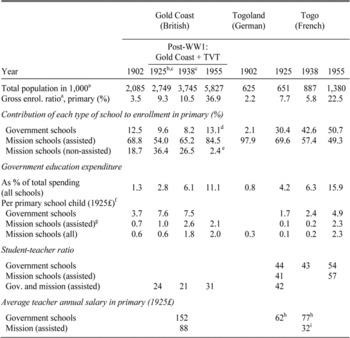
The educational systems of the different regions are highlighted in Table 1. About 90 percent of all students in the Gold Coast were enrolled in mission schools throughout the colonial period. Many of the schools received grants-in-aid from the state. German colonial administration in Togo also relied heavily on government subsidized mission schools (Lange Reference Lange1998). The pattern in French administered Togo, in contrast, stands out. From the start there were more government schools and their role grew over time, so that in 1955 more than 50 percent of students went to government schools.
In 1902 Gold Coast schools were eligible to receive grants if they could show a minimum daily average attendance of 20 students and proper school accounts. Capitation grants were proportional to average attendance and to students' grades in “Reading and Writing of the English Language and Arithmetic” at the annual inspection (Gold Coast 1920). By 1925 grants conditions had become tougher, more subjects had to be taught and teacher qualifications also mattered. Not all mission schools met these requirements, but they could still operate unassisted until an Education Ordinance in 1927 introduced a minimum of formal teacher qualification for all schools. There were 136 “bush schools” closed down (Williams Reference Williams1964).
In Togo, in 1925 subsidies were given to registered schools teaching in French and following the official curriculum, as a fixed amount for each pupil succeeding at the exams for the end of primary school (Gouvernement Français 1925). In 1929/30 mission schools were put under direct governmental supervision and had to follow the same rules as government schools (Gouvernement Français 1930). The teaching of the vernacular was first prohibited and then limited to one hour per school day. In compensation, the government paid for two-thirds of qualified teachers' wages. More than two-thirds of mission schools did not comply, were deauthorized, and closed or transferred into catechumenates. These establishments could teach basic reading, writing, numeration, hygiene, and “morality” in vernacular languages, but received no government support (Gbikpi-Benissan Reference Gbikpi-Benissan2011).
FEATURES OF THE EDUCATIONAL SYSTEMS IN GHANA AND TOGO

a Because colonial censuses underestimated the population, the figures were derived by extrapolating from 1960 numbers reported by UN Population Division (2011), assuming Ghana's demographic growth 1901–1960 as estimated by Austin (Reference Austin2007, p. 107) indiscriminately for all territories. We used Manning's (2010) estimate of the TVT/Togo population ratio of 37.4/62.6 to calculate Togoland population in 1902. School enrollment rates are very similar when based on alternative population estimates from Manning (2010) and Frankema and Jerven (2013). School-age population is assumed to be 20 percent of the total population.
b 1925/26 excludes Ewe Presbyterian schools (in British Togoland). Though salaries were paid by the government, Ewe Mission schools were not listed in Education reports or Blue Books.
c 1925 and 1938 Gold Coast figures include “upper primary schools” (class 7–10), but exclude middle schools (also class 7–10).
d Includes 568 “Local Authority Schools” equivalent to government schools.
e Figure refers to private schools.
f French Togo expenditures were transferred into pounds using the official exchange rate; both series were expressed in constant 1925 £ using the UK retail price index as deflator (Times Newspaper, 1971).
g Costs borne by the government through grants-in-aid.
h Total personnel expenditures divided by number of teachers.
i In 1938 the French government paid a subsidy of two-thirds of the wages for 62 teachers in the mission sector; this represented a per-teacher grant of £21 in 1925£, from which we infer 32 = 21/(2/3).
Sources:
Gold Coast (various years-a, b); Kolonialamt (Reference Kolonialamt1903); and Gouvernement Français (various years).
We hypothesize that the political choice of school mix had a profound impact on school supply and literacy. For governments using mission schools cut cost over public schools (Table 1). First, subsidies did not cover the full costs of mission schools. From the accounts schools submitted in the Gold Coast, we can infer that subsidies covered about 50 percent of costs in 1902 and 1925, then 66 percent in 1938 and 100 percent in 1955 respectively (Gold Coast 1903a, 1926a, 1939a). The rest was made up by school fees and voluntary contributions. For Togo, the situation is less clear. In 1938 subsidies covered two-thirds of the teacher salary if qualified. Education was free, which meant that mission schools could not fall back on school fees. Secondly, mission schools had lower costs than public schools. Teacher salaries in 1938, for example, were about half of what teachers received in the government school sector.
Contrary to the stylized facts about colonial educational systems, total expenditure on education was higher in the British colony. Although comparisons are difficult because of exchange rate variability, the Gold Coast spent much more than Togo on education (3 to 4 times more in per capita terms in 1925 or 1938).Footnote 13 It was richer and could use cocoa export taxes to raise revenue. However pre-World War II British Cameroons where fiscal income per capita was much lower and at par with French Togo had the same high level of spending for education as the Gold Coast (Dupraz Reference Dupraz2013). Higher subsidization of mission schools not only translated in higher enrollment, but also in lower student to teacher ratios: 20 to 30 on the British side, relative to 40 to 50 on the French side. This also implies that one should not dismiss an impact on literacy from quality of schooling—if costs (including teachers' wages) and student-teacher ratios are correlated with quality. But the fact remains, the Gold Coast government kept per pupil expenditures low by using mission schools and with a fixed budget that should have increased school supply.
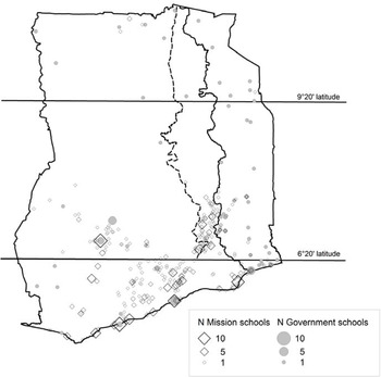
Education was a similar share of government budgets and followed a similar trend in both colonies; the share was low in the pre-World War II period, but increased steadily, to 11 percent and 16 percent in 1955 in Ghana and Togo respectively.Footnote 14 Enrollment rates were generally low before 1940s, probably less than 20 percent. Before World War I, the Gold Coast's enrollment rates were roughly on par with Togoland; during the interwar period enrollment rates in the Gold Coast exceeded the ones in Togo. Ghana's education programs started during World War II whereas Togo took off one decade later. The aggregate figures give a first indication of the role of missions, but they are not conclusive. Estimates of the school age population are crude approximations. In the Gold Coast, unassisted schools were not required to report their enrollments until 1945 and therefore did not do so systematically. Gold Coast and Togo schools may lack comparability both in terms of what constituted a school and in terms of efficiency and quality. Table 1 also masks pronounced spatial differences.Footnote 15 Figure 2 shows the location of primary schools in 1938. In the Gold Coast, schools were concentrated in the south, and only a handful of mostly government schools were located in the north. Togo showed little difference in the geographic pattern.
DATA
Colonial Army Recruits Data
For the colonial period, we use a new data source: attestation papers of men recruited to the Gold Coast Regiment (GCR), the British colonial army in Ghana. The data was collected from military personnel records held by the General Headquarters of the Ghana Armed Forces in Accra, Ghana. The army data represents the best available “survey style” records of the colonial time providing a wealth of information on the recruit's background such as age, place of birth, ethnicity, and previous occupation.
We measure literacy by the ability to sign one's name. Every recruit had to take an oath of allegiance and sign a declaration which legally subjected him to military rules and regulations. Here we find recruits' signatures, x marks, or thumbnails. Signature literacy is widely used by historians (Rachal Reference Rachal1987); it measures the outcome of schooling which, in our context of possibly wide differences in quality of schooling, is a good property (Wagner Reference Wagner1990). The level of signature literacy usually falls below reading skills and above writing skills (Rachal Reference Rachal1987). In our sample, signature literacy is strongly correlated with self-reported formal schooling.Footnote 16 The army measured recruits' height and we use this as indicator of nutritional status (Moradi Reference Moradi2009; Steckel Reference Steckel2008). Finally, the recruits' religion informs us about the missions' direct impact and the channel from proselytization to literacy.
GEOGRAPHICAL LOCATION OF GOVERNMENT AND MISSION SCHOOLS 1938

We retrieved the geographic coordinates of recruits' birth places by matching place names from the GEONet Names Server (National Geospatial-Intelligence Agency 2007). We identified 77 percent of the places of the ethnic groups who mostly resided in Togo. Much of the attrition is due to duplicate place names (a regular feature of Africa), that prevent identifying the location, stating place names in local languages and misspellings. British officers also did not follow French and German spellings of place names, which made it particularly difficult to identify small places in the GEONet database.Footnote 17 Hence, there is a somewhat higher attrition of recruits born in rural areas outside Gold Coast. Assuming less access to schooling, missionary activities, and health in rural areas, this selection effect tends to bias our estimates of religion, education, and height in German Togoland and French Togo against our hypothesis.
The GCR data set consists of a complete sample of recruits enlisted between 1908 and 1939. We under sampled the 1939–1945 enlistment period as more than 60,000 men served in the GCR during World War II. For the post-World War II, period only odd regimental numbers were selected. From the original sample of 24,984 recruits, only 22,410 have year of birth reported. We limit our analysis to recruits who were born between 1890 and 1930, as sample sizes are too small for years outside that range, especially from peripheral regions; this again removes 2,826 observations. Then, over a total of 19,584 recruits, the place of birth could be retrieved for 15,193, of whom 11,940 were born in either Togo or Ghana.
Present-Day Survey Data
For the post-independence period, we use the nationally representative household members' samples and males' samples from the 1998 Demographic and Health Survey (DHS). We complement the sample with the 1998 Ghana Living Standards Measurement Survey (GLSS4). These two surveys provide comparable figures on educational attainment, (self-declared) ability to read, and religion.
Colonial School Data
To more fully investigate school supply, particularly exposure to government and mission schools, we collected information on school location in 1902, 1925, and 1938. Education reports and statistical yearbooks recorded the number of schools by locality (Gold Coast 1926b, 1939b; Gouvernement Français 1925, 1938; Kolonialamt 1902/Reference Kolonialamt03); their geographic coordinates were retrieved from the GEONet data base. The location of government schools is always precise, but information on mission schools is less detailed and partly incomplete. For the Gold Coast, we only have information on mission schools that were on the assisted list. Hence, we omit non-assisted mission schools. Moreover, locations of a few mission schools had to be assumed either at mission stations or at the district capital (see Table 4 footnote). In total, we have 127 government and 1,039 mission schools in 400 localities.
STATISTICAL METHODS
Colonial Period Divergence
To analyze the natural experiment generated by the post-World War I partition of German Togoland, we implement two difference-in-difference strategies, in levels and in trends, on the cohorts of soldiers born in border areas.
To draw causal inference about the impact of British and French education policies, we can start with a simple strategy: compare the British Trans-Volta Togoland (TVT) area with the French Togo area before and after the partition. As primary schooling starts at age six, 1914 can be taken as the cutoff birth year: military recruits born after 1914 were only exposed to either British or French educational policies after 1920, whereas recruits born before 1914 could have started their school curriculum under German rule.
We restrict the comparison to recruits born close to the borders. As TVT is a rather narrow strip, we include all recruits from this area. We add recruits from Togo and the Gold Coast whose place of birth lies less than 50 km from the borders of TVT. Furthermore, as the southern border of TVT follows a straight latitudinal line at 6°20' (6.3 degrees), we exclude from our main estimation sample any recruit born below this line. We define two subsamples: born in South, i.e., between 6.3 and 9.3 degrees of latitude; born in North, between 9.3 and 11.3, to reflect the North-South divide in evangelization efforts and school supply. The TVT strip is narrow so nearly 90 percent of recruits were born no further than 50 km from the eastern border with Togo; likewise, out of the 439 recruits born above the 6.3 parallel in Togo, the 50 km bandwidth selects nearly three quarters of them. Finally, Gold Coast recruits play a very minor role, as they mainly contribute to the identification of some control variables' coefficients like latitude. They are however useful for interpretation.
We estimate a standard difference-in-difference (DiD) regression

where Y is the outcome under study (literacy, religion, height). j indexes the areas of birth: 0 = Gold Coast, 1 = TVT and 2 = Togo. B is a dummy for that area of birth, T is the year of birth, and T
0 = 1914. X is a set of control variables. With those notations, the parameter of interest (double-difference) is  Errors u are clustered by place of birth.
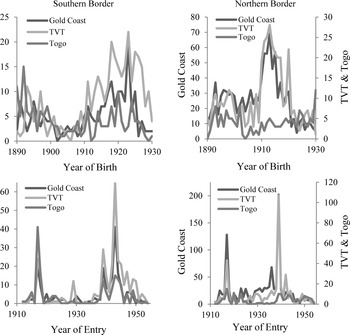
Birth cohort size is an important issue. Figure 3 shows large variations across time in the number of soldiers recruited. In particular, the two World Wars generated peaks (bottom panel graphs), and unsurprisingly the World War II peak is more pronounced in TVT and the Gold Coast. Many recruits of World War II were born in the 1910s, the average age at enlistment being 24-year-old (top panel graphs). As a result, early years (1914–1924) represent a disproportionate share of the post-1914 group compared to later years (post-1925). To correct for this, we reweigh recruits according to year of birth, assuming a 2 percent demographic growth rate in each of the six areas defined by the historical partition and by the North-South disaggregation.Footnote 18 Unweighted estimates are nonetheless also considered. Our simplest DiD estimates are first computed without controls, on each of the two subsamples, North and South separately. We then implement a series of tests to explore their validity and robustness.
To interpret the DiD estimates as causal inference requires assuming that literacy rates follow a common trend. The equality of pre-1914 levels 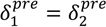 is consistent with that assumption. However, our data allow us to go further and instead of looking at levels, to test for a differential break in the trends of outcomes at the cutoff birth year 1914. We call this alternative model by the acronym DiD-T, and estimate the following linear probability regression
NUMBER OF RECRUITS FROM EACH BORDER AREA, PLOTTED BY YEAR OF BIRTH AND OF ENTRY


where, as above j indexes the area of birth and B is a dummy for it; T is the year of birth, and T
0 = 1914 is the kink-point year chosen for the trend break tests. Errors v are clustered by place of birth. Ideally, we wish to show first that the two groups born in German Togoland did not differ in level in 1914 (α1 = α2); second that the same two groups had the same trend under German rule  that TVT after being merged with the Gold Coast had the same trend
 We provide statistical tests for these three requirements (and check that they indeed hold for all our estimates). Finally, the double-difference in trends
 will measure the extent of a break due to differential policies.
Present-Day Border Discontinuities
In order to maximize comparability with the estimates for the colonial period, we apply the same sample selection rules to present-day survey data: we restrict to the 100 km wide strip lying across the Ghana/Togo border, and drop localities located below the 6°20' latitude. We first test for the significance of difference in means across the border. Then, following the methodology for regression discontinuity designs (Hahn, Todd, Van der Klauuw Reference Hahn, Petra and Wilbert Van der2001; Lee and Lemieux Reference Lee and Thomas2010), we identify border discontinuities using locally quadratic regressions

where Y is the outcome of interest, B = 0, 1, is the border side (or country) of residence, and D is the distance to the border, positively signed for B = 1 and negatively signed for B = 0, so that: B = 1{D ≥ 0}. X is a set of geographical controls (latitude and altitude). Errors ε are clustered by surveys' primary sample units.Footnote 19
For border discontinuities to reflect the causal impact of national policies (even locally), it is required that border localities are not sorted into “types” by the boundary alignment, where “type” determines outcomes. This first requires this alignment to have been sufficiently hazardous in 1919.Footnote 20 Another important condition is that types of people did not “manipulate” their distance to the border through migration. International migration from Togo to Ghana was not rare during the colonial period up until 1965, although part of it was only seasonal.Footnote 21 After 1965 and until the 1990s, flows reverted because of economic and political crises in Ghana, however Ghanaians mostly emigrated to Nigeria (Anarfi and Kwankye Reference Anarfi, Stephen, Ofuso-Mensah and Richmond2003). Internal migration could generate a larger bias, because one country capital city can be more attractive than the other. Lomé is much closer to the border than Accra, but including all Lomé residents in the border discontinuity estimation would rather reverse the bias than cancel it. Surveys unfortunately did not collect the place of birth. Yet, to account for internal migration, we can compare partitioned ethnic group members, in particular Ewe, whatever their place of residence (within the border area or elsewhere in each country).
COLONIAL ORIGINS OF BORDER DISCONTINUITIES
We first make the case for the divergence in literacy and religion after the 1919 partition, using the GCR data. We then relate this divergence to the school supply channel.
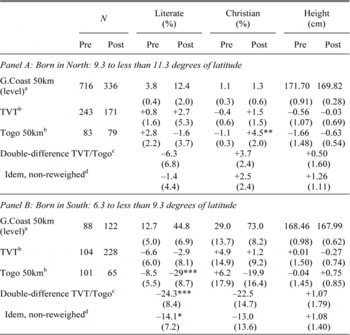
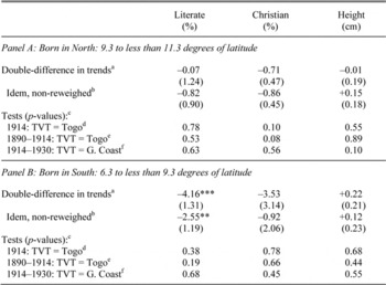
Table 2 shows DiD estimates at the TVT-Togo border for literacy, Christian religion, and height. The top panel looks at recruits born in the northern border area, the bottom panel at recruits born in South. The table suggests that partition had no effect in the North. For recruits born after 1914, the share of literate individuals increases by more than 10 percent everywhere while the share of Christians remains negligible; height variations are insignificant. In the South, all three outcomes are the same for cohorts born before World War I on both sides of the border. In contrast to the North, however, around one third of recruits declared themselves as Christians. After World War I, TVT outcomes rise to Gold Coast levels, whereas Togo's literacy rate and share of Christians lag behind. The DiD estimates point to a more than 20 percentage points divergence between 1914–1930 cohorts born on either side of the partition border: 24 pp for literacy, and 22 pp for Christian religion, the latter estimate being statistically imprecise. Finally, we find no significant divergence in height.Footnote 22
Table 3 presents DiD-T estimates, for the same outcomes and populations. Results are in line with those of Table 2. The statistical tests for the pre-treatment comparability of the two areas are convincing: TVT and Togo recruits born around the kink-point year 1914 displayed close levels of outcomes (α1 = α2), and were located on common pre-treatment trends (1890–1914) for these outcomes ( ). As with the DiD estimates, the northern areas show no change in those trends after partition. Again, it is in the South that we find a differential trend break for literacy. DiD-T estimates point to a high rate of divergence after 1914, about 4.2 percentage points per year over 15 years (2.5 for the non-reweighed estimate). While very large, this order of magnitude is broadly consistent with the 20–25 percentage points DiD estimate, as the latter figure is an average between early cohorts born just after 1914 and late cohorts born at the end of the 1920s. Of course, this pace of 4 pp a year could not be sustained forever, as literacy rates are bounded between 0 and 100 percent. Sample sizes however preclude identifying nonlinear dynamics.Footnote
23
These results mainly reflect Togo lack of progress in literacy before World War II, as post-1914 trends are about zero. In contrast, TVT caught up with the Gold Coast; it always records a positive rate of increase, even higher than Gold Coast proper, although never significantly so according to the third row of tests

AT THE TOGOLAND BORDERS BEFORE AND AFTER WORLD WAR I: DOUBLE-DIFFERENCES

* p < .10.
** p < .05.
*** p < .01.
a Mean level of outcomes in Gold Coast 50 km. Statistical significance is not reported; all mean levels are different from zero at 95 percent confidence.
b Simple difference with Gold Coast 50km:  where p = pre, post and k = 1, 2.
c Double difference between French Togo and British Togoland: 
d Raw estimates, without reweighing by demographic growth.
Notes:
Clustered standard errors, by place of birth (in parentheses). “DiD” estimates, see equation 1. Pre = Born 1890–1913; Post = Born 1914–1930. Sample sizes (N) are for the “Literate” outcome (North = 1,628; South = 708); a few missing values reduce the sample sizes for “Christian” (Nth.= 1,503; Sth.= 676) and “Height” (Nth.= 1,593; Sth.= 683). Year of birth cohort sizes are reweighed assuming a 2 percent demographic growth rate from 1890 to 1930 in each of the six areas.
Source and Coverage:
Gold Coast Regiment data. Recruits enlisted 1908–1955, born 1890–1930. TVT: Whole area. Gold Coast (resp. Togo) 50km: recruits born in Gold Coast (resp. French Togo), no further than 50 kilometers from the border with TVT.
AT THE TOGOLAND BORDERS BEFORE AND AFTER WORLD WAR I: TREND BREAKS

* p < .10.
** p < .05.
*** p < .01.
a Coefficient  in percentage points per year, see the text.
b Raw estimates, without reweighing by demographic growth.
c Tests are for reweighed estimates.
d Test α1 = α2, see the text.
e Test  see the text.
f Test  see the text.
Notes:
Source and Coverage:
Gold Coast Regiment data. Recruits enlisted 1908–1955, born 1890–1930. TVT: Whole area. Gold Coast (resp. Togo) 50km: recruits born in Gold Coast (resp. French Togo), no further than 50 kilometers from the border with TVT.
Evangelization exhibits the same divergence (–3.5 pp a year) as literacy, but is again not precisely estimated. Finally, DiD-T estimates confirm that height stature evolutions were not affected by the Togoland partition. As OLS estimates could be biased due to minimum height requirements at entry (Komlos Reference Komlos2004), we estimated truncated regressions with a variety of height minima from 60 to 65 inches and found this result to be robust.
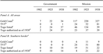
We now turn to divergence in school supply. Table 4 summarizes the school data that we collected for the years 1902, 1925, and 1938. Recall that the count of mission schools is restricted to assisted schools on the British side, and authorized schools (“écoles reconnues”) on the French side. We disregard unassisted schools because they were not accurately recorded. Table 4 offers three lessons: First, mission schools constituted the bulk of school supply in all areas, especially in TVT where only one government school was settled before World War II. Second, the number of mission schools grew between 1902 and 1925, even in the former German Togoland where the British and the French had expelled German and Swiss missionaries and this growth continued between 1925 and 1938 in the British part. Third, in French Togo nearly three- forths of the authorized mission schools were deauthorized between 1925 and 1938. Yearly aggregate figures show that collapse occurred in the years 1930/31 after the French administration imposed new regulations on private schools.
In each panel of Table 4, a fourth row proposes an alternative count of mission schools for Togo. In 1930, as already explained, some deauthorized schools were closed, others were transformed into catechumenates. The decision was based on the assessed poor quality of teaching, so that one could think that even before 1930 those schools were not comparable to British assisted schools. This fourth row then provides an alternative evolution of school supply in Togo, by only counting authorized schools as of 1938 for all years. By construction, we then no longer observe a collapse, but rather stagnation in “true” mission school supply between 1925 and 1938.
NUMBER OF SCHOOLS, 1902–1938

Notes:
a From 6.3 degrees of latitude to less than 9.3. Schools no further than 55 km from the border of British Togoland with either Gold Coast or French Togo.
b Assisted mission schools only, according to British rules, except for TVT 1902.
c Authorized or approved mission schools in 1925 and 1938, according to French rules (écoles ‘reconnues').
d In 1930 the authorization policy was enforced much more stringently. Many mission schools lost authorization (and assistance), and were either closed or turned into catechist schools. This row proposes an alternative retropolated counting of schools for 1902 and 1925: non-approved mission schools as of 1938 are not counted in 1902 or 1925 either.
Notes:
The 1902 German statistical yearbook did not list the schools of the Bremen Mission (“Norddeutsche Missionsgesellschaft”). We use the location of mission stations instead, i.e., we allocated 34 Bremen Mission schools to their 31 missions (hence 34/31 schools in each mission). Likewise, none of the schools of the “Ewe Presbyterian Church” was on the Gold Coast assisted list of 1925, despite teacher salaries being paid by the government. The Ewe mission had 49 schools, 17 of which we identified through a list of exam candidates, so that we assigned the remaining 32 schools to 36 mission stations locations (hence 32/36 school in each). Finally, the 1925 yearbook of French mandated Togo only gives summary statistics for the Catholic and Evangelic mission by district, not locality, whereas schools of the Wesleyan Mission (Methodist) were given by locality. We entered the geographic coordinates of the district capital.
Sources:
Gold Coast (various years-a, b) and Gouvernement Français (various years).
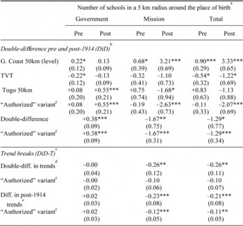
For both alternative counts of mission schools, we create a variable giving the number of schools that were available to each GCR recruit at the age of 10 within a 5 kilometers radius around his place of birth and within the colony he was living in. Table 5 shows what the aggregate evolutions in school supply mean at the level of the individual recruit. It suggests that the school supply channel is a good candidate for explaining the observed divergence in education and religion.Footnote 24 We compute DiD estimates (top panel of Table 5) and DiD-T estimates (bottom panel) for the number of schools of each type. Both point to a post-1914 divergence in school supply between TVT and Togo. DiD suggests that Togo lagged behind TVT in school supply by more than one school on average; even if more government schools were opened on the French side (0.4 more schools on average), this did not compensate for the relative loss of 1.7 mission schools. The trend break estimates point to an even stronger divergence of around 0.2 schools per year between 1914 and 1930, i.e., a difference of three schools among recruits born in 1930. The “authorized” variant, using our alternative counting of Togo mission schools, tells a similar story: DiD estimates are unchanged, and by construction DiD-T point to a slower but still significant divergence of around 0.1 schools per year. We find no such divergence in the northern part of the border (result not shown), rather a tiny French advantage, visible on the map for 1938 (Figure 2).
DIVERGENCE IN SCHOOL SUPPLY AT THE SOUTHERN TOGOLAND BORDER

* p < .10.
** p < .05.
*** p < .01.
a and in the relevant colonial territory. For each recruit's place of birth in the GCR data set, we first compute the number of schools lying in the 5 km radius and in the relevant territory for 1902, 1925, and 1938. We take ten years as the benchmark age for primary school. Recruits born before 1892 (resp. after 1928) are matched with the 1902 (resp. 1938) number of schools in their place of birth. Then intermediate cohorts born 1892–1915 (resp. 1915–1928) are matched with an interpolation of the 1902 and 1925 (resp. 1925 and 1938) number of schools.
b See Table 2.
c See Table 3.
d

e

f Non-authorized schools in 1938 are not counted in 1925 or 1902 either. See Table 4.
Notes:
Clustered standard errors, by place of birth (in parentheses). Cohort sizes reweighed assuming a 2 percent annual demographic growth over 1890–1930, see Table 2 and text. Pre = Born 1890–1913; Post = Born 1914–1930.
Source and Coverage:
Gold Coast Regiment data and school data (see Table 4). Recruits enlisted 1908–1955, born 1890–1930. TVT: Whole area. Gold Coast (resp. Togo) 50km: recruits born in Gold Coast (resp. Togo), no further than 50 kilometers from the border with TVT.
BORDER DISCONTINUITIES AFTER 1940
We now turn to border discontinuities in adult literacy and religion in 1998, using a survey sample of males born between 1930 and 1979. At the national level, there is some convergence in primary school enrollment: among the youngest cohort (1955–1979), 85 and 77 percent of men had ever been to school in Ghana and Togo respectively, i.e., a gap of 8 pp. In contrast, a very persistent 29 pp gap in favor of Ghana is observed for primary level completion, despite much progress on both sides since the postwar period. As a consequence, the literacy rate, here measured by self-declared ability to read “easily,” is 17 pp lower in Togo (74 percent vs. 57 percent). In terms of Christian religion, there is a similar difference with Ghana at 72 percent and Togo at 53 percent.
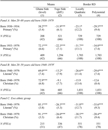
When restricting to border areas, in the northern part we do not find any discontinuity, neither in primary school attendance nor completion nor literacy (results not shown). In contrast, the southern part exhibits large discontinuities, as shown in Table 6. In the case of primary level completion (top panel), a very significant 32 pp difference is found among the 1930–1954 birth cohorts, that is only slightly decreased by true regression discontinuity (RD) estimates (−23 and −29 pp). Among 1955–1979 birth cohorts, the mean gap at the border (22 pp) is not far from the national level difference (29 pp), and it gets even larger with RD estimates (32 to 34 pp).
AT THE BORDER OF TOGO WITH GHANA IN 1998 (SOUTH)

* p < .10.
** p < .05.
*** p < .01.
a Primary = Completed primary level.
b Literate (self-declared) = “Reads easily” in DHS, “Can read a letter” in GLSS.
c Only a subsample of males 15–59 years-old were surveyed on literacy and religion.
Notes:
Clustered standard errors, by Primary Sample Units (in parentheses). Probabilistic sample weights used, adjusted for sample rate differences between the two countries. Column 1: Ghana 50 km sample means. Columns 2–4: Positive (resp. negative) numbers indicate differences in favor of Togo (resp. Ghana). Column 2: difference between Ghana 50 km and Togo 50 km sample means. Column 3: Locally quadratic regression in distance to the border on each side, coefficient γ in equation 3. Column 4: Cubic polynomial in latitude and longitude, see Dell (2010). Controls (only border RD): Dummies for each half degree of latitude, and for each 100 meters of elevation (from 0 to 300 or more).
Source and Coverage:
Ghana and Togo Demographic and Health Surveys 1998. Ghana Living Standards Survey 1998. Male individuals 20–69 years old whose residence lies no further than 50 km from the border, and between the 6.3 and the 9.3 parallels.
Literacy and religion were only collected for a reduced sample of men, which forced us to put all 1940–1979 cohorts together. Compared to the national level, the difference in means between the two border areas is reduced, especially for Christian religion (Panel B). However, RD estimates again point to a large difference in literacy (27–30 pp), meaning that distance to the border matters.
When restricting the comparison to the Ewe ethnic group (Panel C), then mean difference and border RDs become very consistent, and again point to a large handicap in literacy on the Togo side. Border discontinuities in Christian religion are also found to be large. The surveys unfortunately did not collect the place of birth of individuals. As results may be biased by selective migrations to places like capital cities where returns to education are higher, we compute the mean difference among all Ewe males from the same birth cohort, whether they are found in border areas or elsewhere in the two countries. For the 1940–1979 cohorts, the difference in literacy rates between Ewe living in Ghana and Ewe living in Togo is a highly significant 16pp; the figure for Christian religion is only 11pp but still very significant.
For cohorts born in the late colonial or the early post-colonial periods, these results are strikingly in line with what we found using the colonial military data for earlier cohorts (1914–1930): (i) a large gap in literacy, and a persistent shock on evangelization; (ii) no impact in the North, and no impact on height.Footnote 25
INTERNAL VALIDITY OF THE HISTORICAL PARTITION AS A POLICY EXPERIMENT
Let us now return to the GCR data and explore the internal validity of our DiD and DiD-T estimates. We implement a series of tests to check the robustness of our specification of the border discontinuity. We also want to exclude potentially confounding factors like geography, infrastructure, ethnicity, or skill-biased selection.
Geography
We varied the bandwidth (50 km, then 25 km); then we extended the southern comparison below the 6.3 latitude line, hence including the capital city of Togo, Lomé, as place of birth. We also implemented our DiD and DiD-T estimators on geographical variables as outcomes, to examine whether variation in these variables could confound our estimates of the impact of partition on education or religion. We used a first set of variables to capture differences in natural geography: latitude, altitude, ruggedness of terrain (Nunn and Puga Reference Nunn and Diego2012), and a second set to capture infrastructure: distance to cities, railroad lines, and cocoa production. The estimates showed that ruggedness could pose a threat to causal inference, but only for the DiD estimate. We then introduced each of the two sets of geographical variables as controls in our main DiD and DiD-T estimates and the results did not change relative to those reported in Tables 2 and 3. We also produced a full-fledged border discontinuity estimate, using distance to the border as an additional control variable. Finally, we built a placebo test where we replaced the TVT/Togo border by the border between Gold Coast and German Togoland. At this placebo border, we showed that the divergence in literacy was statistically insignificant.Footnote 26
Selection into the British Army
A remaining concern with our results comes from changes in recruitment selectivity from each of the two areas, TVT and Togo. These evolutions could stem from recruitment policy, or, because GCR recruitment was voluntary, from differential self-selection of applicants linked to the changes in outside options in the French vs. British labor markets.
To begin, labor markets were rather integrated during colonial times. The economy of the Gold Coast depended on the inflow of labor migrants and cross-border movement of labor was unrestricted (Cordell and Gregory Reference Cordell and Joel1982). Cocoa farms and mines in Ghana's forest region attracted large numbers of unskilled workers from Ghana's North and French West Africa, in particular Burkina Faso (Rouch Reference Rouch1957); Togolanders from both sides of the border migrated to the more dynamic areas in the West (Ward Reference Ward1950). The GCR as an employer did not discriminate against non-British Africans: roughly 30 percent of servicemen were born outside of Ghana. Language was not a job requirement. English and Hausa were used to communicate in the army—languages that were not vernacular for British Gold Coasters (Killingray Reference Killingray1982). Furthermore, due to the League of Nations mandate, Togolese men were exempted from military service on the French just as on the British side. Despite of this, the army did not take everyone. Physical fitness was a requirement. British officers also believed that men of exceptional soldierly qualities came from certain ethnic groups (the so-called “martial races”) and could have preferred them as long as enough men put themselves forward. Overall, our sample of recruits is not a random draw or representative of the male population. For our purpose, however, selection effects are less important than one might initially think, thanks to our econometric strategy. First, as the border divided ethnic groups, any preference for a certain ethnic group applies to their members on both sides of the border; one such “martial race,” for example, was the Konkomba who straddled the border. Second, any time-invariant difference in selection across borders will be canceled out by double-differences in levels or in trends.
We checked with multiple sources that the TVT/Togo boundary does not correspond to delimitations between distinct precolonial polities or cultural areas. Even if ethnonyms and typologies vary between sources, all of them confirm that the border actually split many ethnic “homelands” (Brownlie Reference Brownlie and Ian1979; Dickson Reference Dickson1969; Lewis and SIL International Reference Lewis2009; Murdock Reference Murdock1959; Nugent Reference Nugent2002; Olson Reference Olson1996). GCR recruits were also asked about their ethnicity, so that we could directly identify partitioned ethnicities: One major group is the Ewe in the South, and from North to South, the Moba (Bimoba), Anufo (Chakossi), Konkomba, Basare, and Kotokoli (Tem). Our literacy estimates were robust to restricting analysis to the subsamples of Ewe recruits, or of partitioned ethnicities more generally.
Yet, the changing composition of the GCR sample over time remains a concern. The World War II increased the demand for skilled personnel, and just after World War II the professionalization of the army further accelerated. Among recruits from the border area, the average share of literate or skilled individuals exhibits large upward shifts after 1938 and after 1946. At the same time, fewer recruits were coming from Togo during World War II, while more Ewe recruits from the southeast were recruited from both sides after World War II. As a first check for variations in recruitment, we included year of enlistment fixed effects as an additional control. This way we accounted for the fact that the GCR could have recruited more or less literate individuals during some periods, whatever their geographical origin. DiD and DiD-T were reassuringly unaffected.
The latter strategy, however, does not rule out time-varying differential selective recruitment according to geographic origin. Men of higher socioeconomic background found military service and wages less attractive compared to other employment opportunities. We believe that this general reluctance applied to each area. However, during World War II individuals with skilled occupations could have been coerced into the GCR more successfully within the Gold Coast territory, while at the same time the government of AOF, loyal to Vichy, had closed the borders with British colonies. Besides, improved job offers in post- World War II Togo could have induced skilled individuals to stay in the country rather than to apply to the GCR abroad. To deal with these possibilities, we dropped recruits who declared a skilled occupation, while still controlling for date of entry. This way we only compared recruits who entered the GCR the same year and who were originally working as farmers or in another unskilled/semiskilled occupation. We acknowledge that this strategy is not an unambiguous improvement, as it relies on the assumption of a constant correlation between literacy and skilled occupations (across time and space). Yet, our estimates passed this additional test and with these restrictions, the divergence in Christian religion increased. In fact, whatever their area of origin (TVT or Togo), 88 percent of skilled recruits born after 1914 are Christian. Our interpretation is that GCR recruitment was biased towards skilled men or even skilled Christians, so that including them blurs our estimates of the divergence in religion.
We also used data of recruits to the French army regiment based in neighboring Dahomey (today Benin). We selected Togolese volunteers for whom literacy and/or religion were recorded, and included them in the regressions, while controlling separately for year of entry in each of the two regiments. That way we allowed for the possibility that literate Togolese could have preferred joining the French army rather than the British. Results again remained unchanged.Footnote 27
We still acknowledge that we do not entirely rule out the possibility of an upward bias on our estimate of post-partition divergence; indeed literate Togolese could have found the option to stay in Togo more and more attractive, compared to joining the GCR in Ghana. However, the divergence in school supply that we also identified is not affected by these selection issues. The same is true of the differences in education that we observed in survey data, for the cohorts born after 1930 but before independence. These elements make us confident that the post-1914 divergence observed in soldiers data is not spurious.
CHANNELS OF CAUSATION AND EXTERNAL VALIDITY
We showed that differences in education and religion between Ghana and Togo can be traced back to the post-World War I partition, and that mission schools' supply makes a good candidate for explaining the divergence. We now examine alternative channels of causation, and discuss what is learnt more generally on the contrast between British and French policies in Africa.
One interpretation is that TVT simply benefitted from being merged with a wealthier and more dynamic region (cocoa producing Gold Coast), whereas Togo was left on her own. The difference in wealth should not be overstated however. TVT was not the most buoyant part of the Gold Coast. While cocoa production expanded from the Gold Coast into TVT in the 1920s, it reached the French side in the 1930s. The railroad that Germany started and France continued was on the Togo side. A large share of TVT cocoa beans were crossing the border to be transported to Lomé by railroad; besides, Togolese from the French side could cross the border to work in the Gold Coast on a seasonal basis (Goeh-Akue and Nabe Reference Goeh-Akue, Bammoy and Gayibor2011; Lawrance Reference Lawrance and Gayibor2011; Nugent Reference Nugent2002).
Yet, could a difference in income growth have translated in higher demand for educational services? Several facts are at odds with a demand-driven story. First, a large divergence in parental wealth between TVT and Togo should have translated into height differences that we did not find. Further, according to our estimations military recruits from TVT cocoa producing areas did not tend to be more literate (see the Online Appendix). Second, if returns to education had increased more in TVT, we should observe that TVT recruits became more skilled at the same time. However, when we estimate our models with “unskilled occupation” as the outcome variable, we do not find a significant border effect. Instead, we find the same divergence of literacy when restricting the analysis to recruits with unskilled occupation.
We therefore favor a supply-driven story where British policies differed from the French in the southern non-Islamized areas. The British policies involve: (i) higher spending in education, not necessarily linked to fiscal income;Footnote 28 (ii) higher contributions of subsidized mission schools. In northern areas, no such differences held.
We cannot determine exactly how much of the literacy divergence in southern areas was due to the level of spending in education on the one hand, and to the public/private mix on the other hand. The two elements are interlinked: the French authorities could have counterbalanced their opposition to missions with more secular government schools, i.e., by spending more in education, which they did not. Because of the Great Depression, the 1930s were not a good period for increasing public spending. After World War II, things could more easily change. In 1955 Togo, education expenditures had significantly increased and mission schools were receiving a substantial amount of subsidies, however the contribution of mission schools to total enrollment remained lower than in Gold Coast (Table 1).
We ran simple counterfactual simulations which suggest that, by having the same allocation of spending between government and mission schools as the British, while keeping with their own budget constraint, the French could have closed the gap in enrollment in Togo 1938, or 1955. Of course, observed student-teacher ratio would remain unchanged, so that equal enrollment rates could still translate in different literacy rates.
When thinking of the external validity of this Ghana-Togo comparison, two other pairs seem the most relevant ones, Ghana and its western neighbor Côte d'Ivoire on the one hand, the British and French Cameroons on the other hand. In the first case, survey data reveal that the cohorts born in the 1930s in the southern border counties of Côte d'Ivoire were also much less educated than their Ghanaian counterparts. However, quick convergence in literacy was observed among cohorts born in the 1940s. Côte d'Ivoire even significantly overtook Ghana in the 1970 cohorts, making another example of how “colonial legacy” can be overturned (see the Online Appendix, and also Cogneau, Mesplé-Somps, and Spielvogel, forthcoming). Beside Togo, Cameroon was the other German colony to be partitioned between the British and the French after World War I. Pre-World War II figures tell a similar story, with higher spending for education and stronger support of the missions on the British side (in French Cameroon, the colonial government chose to turn a blind eye to low-quality mission schools; Dupraz Reference Dupraz2013). Using population census data and border discontinuity techniques, Yannick Dupraz (Reference Dupraz2013) observes that the French side was lagging behind the British side until World War II. In the 1950s however, it caught up in terms of education expenditures, adopted a similar public/private mix, and overtook its neighbor in terms of school enrollment.Footnote 29
For the interwar period, the Côte d'Ivoire and Cameroon cases then appear very consistent with the Togo case. In that sense, the pre-World War II differences in educational policy and performance that we identify in the southern part of the Togo border have some external validity. Furthermore, in each case education outcomes were indistinguishable where colonizers chose fairly similar policies against missionaries, in the northern regions. The same is true for Ghana's northern border with French Upper Volta (later Burkina Faso).Footnote 30 We expect the same for northern Cameroon or Niger compared to Nigeria. However, the persistence after World War II was more country-specific. Convergence was achieved rather early in the cases of Côte d'Ivoire and Cameroon, while this process is still under way in today's Togo. In particular, in the 1950s Togo received less funding from the metropolis. Last, even though we favor a supply-driven story for the pre-World War II divergence between non-Islamized areas, and also for post-World War II cases of early convergence, we do not mean that channels of persistence do not involve demand effects. Indeed, it is fairly plausible that intergenerational transmission of preferences for education comes into play at some point, and relay initial supply shocks (see e.g., Wantchekon, Novta, and Klašnja 2Reference Wantchekon, Natalija and Marko013 on Benin). We do not mean either that the link between education and Christian religion has remained constant across time. In 1998 survey data, for cohorts born before 1959 near the TVT/Togo border, the odds of a Christian being literate rather than illiterate is nine times higher than for a non-Christian; this odds-ratio for Ghana being significantly higher (14) than for Togo (7). Yet, for cohorts born after 1960, it goes down to four for both areas.
The association between school and religion fades over time. On the one hand, other channels exist for evangelization, if only simple epidemiological diffusion. On the other hand, with secular state-led school expansion after World War II, more and more non-Christian children got enrolled in all areas.
CONCLUSION
The partition of German Togoland after World War I assigned subjects of otherwise homogeneous communities found themselves to either British or French rule, and later to independent Ghana and Togo. This provides us with an opportunity to study the impact of colonial policies on education. Using a new data set of recruits to the Ghana colonial army 1908–1955, we find that the two mandates of Togoland started to diverge in terms of literacy as early as in the 1920s.
Under the French mandate, a hostile stance was taken against missionary schools, a number of which were deauthorized in 1930/31 without being replaced by secular ones. The British government did spend more on education and at the same time pursued a cost effective policy of mission schools subsidization. This divergence is only visible in the southern parts of Togo and TVT. In the North, educational and evangelization efforts were weak on both sides, and did not produce any significant differences. Applying a border discontinuity analysis to contemporary survey data, we found that the border effects from the colonial times persist today.
This story of supply-driven divergence is able to account for other pairwise comparisons like the southern parts of anglophone and francophone Cameroons, or Côte d'Ivoire contrasted with Ghana, at least before World War II. In the 1950s and after the independences, the two latter examples demonstrate that policies could be changed and that early colonial legacy could be overturned; even today's Togo shows sign of convergence. In northern Islamized regions, our analysis suggests that a British Burkina Faso, Mali, or Niger would have achieved literacy levels no higher than they actually did under their French colonizer.