1. INTRODUCTION
The Hydrographic Institute of the Republic of Croatia (HIRC), issues about 100 navigational charts and 30 nautical publications. In 2001, the HIRC began ENC production of the northern Adriatic area in conjunction with C-map Italy (Altamura, Reference Altamura2003). In 2003 HIRC started its own production of ENC data (Duplančić Leder and Čala, Reference Duplančić Leder and Čala2003, Reference Duplančić Leder and Čala2004).
When ENC production captured the area of the Middle Adriatic, an archipelagic sea, it was concluded that an ENC produced with the paper chart compilation scale contained too many objects that caused clutter on an ENC. The solution to this problem was to apply on-line generalization and multiscale data management, using SCAMIN attribute values. By studying the world literature on this topic, it was found that only two methods of using SCAMIN attributes, the German (7Cs) and the Canadian ones, were available (Bisset and Fowle, Reference Bisset and Fowle2003). According to the PRIMAR questionnaire (Primar, 2006) and our own investigations on ENC data content, user feedback presented several demands: more soundings, more names and SCAMIN coding. The inference was that mariners, being accustomed to paper charts, want ENC to resemble paper charts as much as possible. Taking into consideration the demands of mariners and the recommendations of IC-ENC in ENC production, many HOs use the method of encoding SCAMIN attributes to help reduce the number of objects and to provide an uncluttered display. IC-ENC also recommends the use of standard rounded display scales. This paper defines Croatian (HIRC) methodology to assign SCAMIN attribute values to ENC data in the archipelagic sea area of the Croatian part of the Adriatic Sea.
2. SPECIFIC FEATURES OF THE ADRIATIC SEA
According to the United Nations Convention on the Law of the Sea, Part IV – Article 46 (http://www.un.org/), the term Archipelagic State is defined as a state constituted wholly by one or more archipelagos and may include other islands. Archipelago means a group of islands, including parts of islands, interconnecting waters and other natural features which are so closely interrelated that such islands, waters and other natural features form an intrinsic geographical, economic and political entity, or which have been historically regarded as such. The archipelago area is filled with islands and shallow waters. In an archipelago area navigation is demanding and complex manoeuvres have to be performed with margins counted in metres and seconds (Lüthöft and Nyce, Reference Lüthöft and Nyce2006).
The Adriatic Sea is a semi-enclosed sea forming a distinct sub-region within the Mediterranean Sea region. It is a deeply indented gulf (about 800 km long and 200 km wide), situated between the Apennine and Balkan peninsulas, between longitudes 12° 15′ E and 19° 45′ E, and latitudes 39° 45′ N and 45° 45′ N. The southern border of the Adriatic Sea includes the area of the Strait of Otranto by a line running from the mouth of the Buttrinto River (39° 44′N) in Albania to Cape Karagol in Corfu, through this island to Cape Kephali (these two capes are at latitude 39° 45′N) and on to Cape Santa Maria di Leuca (IHO, 1953). The surface of the Adriatic Sea is 138,595 square km (Buljan and Zore-Armanda, Reference Buljan and Zore-Armanda1976), while the total length of the Adriatic coastline (mainland and islands) is 8,281 km (Leder, Reference Leder2005). The shallowest part of the Adriatic Sea is in the Gulf of Trieste, and its deepest part is in the South Adriatic Pit (1,233 m).
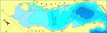
From a geographical point of view, the west and east coast of the Adriatic Sea are completely different. While on the west coast there are only a few islets, the east coast is significantly more indented, with a number of islands, islets and rocks. The Croatian islands area (Figure 1) makes the second largest archipelago in the Mediterranean. The Croatian part of the Adriatic Sea with 79 islands, 525 islets, and 642 rocks and rocks awash (1,246 total) extends over 4,398 km of insular coastline length and 6,278 km of coastline length determined from topographic maps at the scale 1:25 000 (Duplančić Leder et al., Reference Duplančić Leder, Ujević, Čala and Viđak2000, Reference Duplančić Leder, Ujević and Čala2004). Countless straits, passages and other areas dangerous for navigation along this coast cause this area to be an exceptionally difficult and complex navigational area and therefore demand a rigid regime of navigation. The Croatian coast is one of the most indented coasts in the world and after Greece it is the most indented coastline in the Mediterranean.
Bathymetric map of the Adriatic Sea.

Many studies of tides in the Adriatic Sea have revealed that sea level oscillations are of a mixed type with pronounced inequality in height. The most interesting phenomenum of the Adriatic tides is a very well developed amphidromy, where semi-diurnal tides are opposite in phase in the western and eastern coast of the Middle Adriatic (Polli, Reference Polli1960). Tidal amplitudes are small, rising from 0·23 m at Dubrovnik in the south to 0·68 m at Trieste in the north and have no influence on the safety of navigation (Leder, Reference Leder2004). Surface circulation in the Adriatic Sea can be described as a cyclonic meander with a north-west-going current along the eastern coast and south-east-going current along the western coast (Orlić et al., Reference Orlić, Gačić and La Violette1992). Gradient currents are the prevailing cause of this general current system and it is modulated seasonally. Higher-frequency current variability can be of high intensity due to the wind and it is weakly influenced by tidal currents. Currents have little influence on the safety of navigation in the open sea area. Mean current speeds in the open sea are about 0·5 knots (Leder, Reference Leder2004).
The most frequent surface waves in the Adriatic are generated by the Bora and Sirocco winds in the winter, or the Maestrale in the summer period. Characteristics of wind generated surface waves generally depend on the direction, speed and duration of predominant winds, dimensions of the area over which the winds blow (fetch), and topography of the sea bottom (sea depth), generating in the Adriatic much higher Sirocco waves than those of the Bora at the same speed and duration. An absolute maximum wave height in the open North Adriatic was recorded during a persistent gale force Sirocco, where Hmax=10·8 m (significant wave height H1/3=6·0 m, mean period Tsr=8·5 s, mean wave length Lsr=112·3 m). In Bora dominated situations, maximum wave height was also recorded in the North Adriatic: Hmax=7·2 m, H1/3=3·9 m, Tsr=8·5 s, Lsr=112·3 m (Leder, Reference Leder2004).
The Adriatic Sea is a temperate warm sea with a pronounced annual course of surface temperature ranging from 6°C in winter (North Adriatic) to 25°C in summer (open Adriatic). Cooling is most intensive during the winter, under the influence of meteorological factors, when sea temperatures reach their minimum. Freezing of the sea surface is a rare occurrence. During summer, sea surface temperature reach values of 22°C to 25°C, the open sea being warmer than the coastal waters. (Leder, Reference Leder2004).
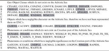
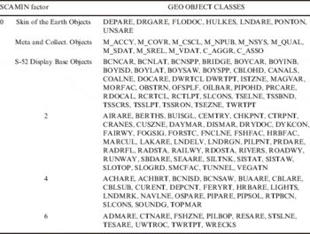
In the eastern part of the Adriatic coast there are no navigable rivers, with the exception of a shallow area navigable only by small boats, which make ECDIS display very suitable for that area. In the coastal area there are no mangroves, salt marshes or swamps to make navigation and berthing complicated. Some Geo object classes do not exist or have negligible significance on the Adriatic Sea, as well as the phenomena or conditions, so we omitted such objects from our study. These objects are irrelevant for the presentation on ENCs of the Adriatic Sea according to IHO standard S-57 (Table 1). Objects marked with a grey background (e.g. CAIRNS) in Table 1 are not used on ENC cells according to S-57 Version 3.1 (IHO, 2000), but those objects were part of the unique cartographic database presented on paper nautical charts as an output product.
Geo Object Classes which do not exist or have negligible character in the Adriatic Sea.

3. S-57 STANDARD, ENC AND ECDIS
The nautical chart is a mandatory tool for mariners on board ship. Together with other navigation equipment, it provides reliable pre-requisites for safe navigation. The ENC is a digital nautical chart produced by the National Hydrographic Office which complies with the International Hydrographic Organization (IHO) standardized product specifications S-57 Edition 3.1, and International Maritime Organization (IMO, 1995) Performance Standards for Electronic Chart Display and Information Systems (ECDIS). The ENC contains all the necessary navigational information shown on paper nautical chart and additional information such as characteristics of an object, names, etc. S-57 describes the standard to be used for the exchange of digital hydrographic data and for the distribution of digital data and products to manufacturers, mariners, and other data users. The most significant digital product being delivered in the S-57 format is the ENC (IHO 2000).
ENC data is presented on ECDIS, which consists of two main elements:
● Data base, called the ENC, containing all necessary geographic information in a digitized form.
● The equipment on board ship necessary for the display of information (integrated bridge system), including real time positioning and route information from navigation sensors (radar, ARPA, autopilot, gyro, echo sounder, wind sensor etc), with the capability of accepting updates to the ENC data (Bessero and Hecht, Reference Bessero and Hecht1996).
When a type-approved ECDIS uses ENC charts data supported by an update service, the system can replace the paper chart on board.
4. SCAMIN ATTRIBUTES AND EXPERIENCES OF OTHER COUNTRIES
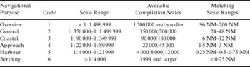
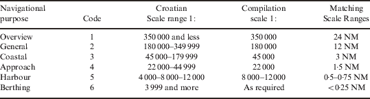
According to S-57 standards, the ENC database was built as a multiscale database which stores nautical data at different scale levels (several digital dataset – ENC cells). This makes it possible for the data to be provided to the ship as a set of “navigational usage”, allowing the navigator to adapt appropriate usage to the situation. According to S-57 standard, ENC is assigned to one of the 6 usage bands dependent on its intended navigational purpose. (IHO, 2004b). As a vessel moves from the open sea towards port, the navigational usage shifts from an overview (least detailed), through general, coastal, approach and harbour level to berthing level (most detailed). The same area and ENC cell objects could be used on different representation levels in different themes or navigational usage, called Multi-representation database (Hardy, Reference Hardy2000). IHO published “Recommendation for Consistent ENC Data Encoding” (Table 2) which proposed navigational purpose assignment to scale range (IHO, 2004a). As S-57 does not define minimum and maximum scale for each usage band, we propose a usage band scale range for archipelago seas and a compilation scale for all navigational purposes (Duplančić Leder, Reference Duplančić Leder2006) (Table 3).
Possible assignment of navigational purposes to scale ranges – a proposal of IHO (2004a).

Assignment of navigational purposes to scale range – a proposal for the Adriatic Sea.
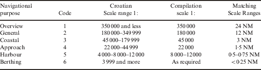
When zooming out the compilation scale (the scale on which the data was originally compiled – attribute “Compilation Scale of Data” CSCALE; IHO, 2000) or using ENC cell for other navigational purposes, an ECDIS display becomes crowded. Therefore, to reduce clutter on an ECDIS display it is necessary to use SCAMIN (scale minimum) attributes. Generalization can be defined as selection and simplified representation of detail appropriate to the scale and/or purpose of the map (ICA, 1973). SCAMIN is the S-57 attribute designed to provide the means for controlling on-line generalization and multiscale ENC data management in the ECDIS (Vachon, Reference Vachon2003). SCAMIN attribute represents the minimum scale at which the object may be used (e.g., for an ECDIS presentation). In order to optimize the performance and clarity of the ENC data, it is strongly recommended that SCAMIN is used (IHO, 2000). SCAMIN attribute allows optimal nautical data representation for any scale and purpose.
The experiences of other countries in using SCAMIN attributes, reported by Bisset and Fowle (Reference Bisset and Fowle2003), indicate that most of the hydrographic offices use one of two methods: the semi-automatic method proposed by an expert group from the Canadian Hydrographic Service (Vachon, Reference Vachon2003), and an automatic method suggested and initiated by the expert group of 7Cs, a German producer of the software package for ENC cell creation (Ulrich et al., Reference Ulrich, Rottmann and Büttgenbach2003). The German (7Cs) and Canadian (CHS) methods of assigning SCAMIN attribute values are based on their own experiences. In analysing these methods we determined that neither of them was entirely suitable for archipelagic sea areas (e.g., eastern Adriatic, Croatia, Greece, Sweden, Norway, Finland, etc.). Therefore we propose a new method of using SCAMIN attributes for archipelagic seas.
5. USING SCAMIN ATTRIBUTES FOR MULTISCALE DATA MANAGEMENT ON THE EAST ADRIATIC COAST
The generalized method for selecting objects of ENC data does not differ from the same method applied for compiling paper charts. However, paper charts are different from ENC cells in terms of representation of data, different resolution – 1000 dpi versus 100 dpi, and way of usage. Among available methods, we took the Canadian method of on-line generalization and then modified and adjusted it further for an archipelagic sea such as the Middle Adriatic.
Table 4 presents a new method (named the Croatian method) of cartographic rules for applying SCAMIN objects coding based on the tradition of compiling charts at the HIRC (Duplančić Leder and Lapaine, Reference Duplančić Leder and Lapaine2005). All objects appearing on ENCs according to this method are classified into 4 groups.
SCAMIN factor assignment of S-57 Geo object classes – a proposal for archipelago seas.

The formula for calculating SCAMIN values was:

CSCALE is compilation scale of ENC cell (see Table 3).
This formula was obtained by experimental examination of percentage decrement of SCAMIN value, ranged from 5% to 25%, by comparison and result analogy with the Canadian method. It was found that the SCAMIN value decreased by 10% gives the optimal density display for an archipelagic sea area (Duplančić Leder, Reference Duplančić Leder2006). So, formula (1) is a modification of the Canadian formula, in such a way that SCAMIN value is decreased by 10%. The SCAMIN values resulting from formula (1) are in agreement with the Croatian method of navigational purposes assignment to scale range and compilation scale proposal for Croatian part of the Eastern Adriatic Sea (Table 2).
The method of real-time ENC content generalization was presented in Duplančić Leder and Lapaine (Reference Duplančić Leder and Lapaine2005). During the method application and following the IC-ENC and IHO recommendations concerning consistency of the same areas in different usage bands and vertical consistency of the ENC data content (Primar, 2006), in Table 4 the object assignment was improved and the number of groups reduced from 5 to 4. As there was no significant difference between the usage of SCAMIN factors 1·5 and 2, these factors were integrated in to factor 2. Furthermore, a large amount of work was noted when applying a SCAMIN value to each object with a high possibility of coding failure. For example for coastal ENC, SCAMIN factor 1·5 is implemented at scale 1:70 000, and SCAMIN factor 2 at scale 1:90 000. It is obvious that there are negligible differences in ENC display on these two scales.
6. GENERALIZATION
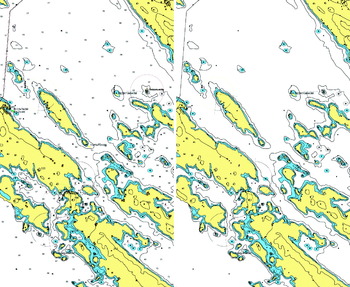
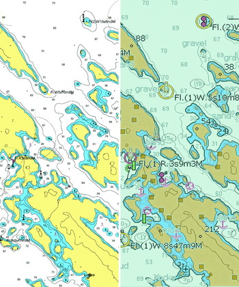
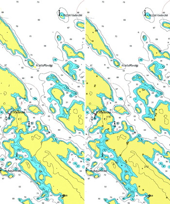
The generalization of data by choosing objects is shown in the example of coastal ENC cell ENC HR31021, with a compilation scale of 1:45 000 using the proposal in Table 3. This ENC presents the wider area of Telašćica Bay, situated in the Middle Adriatic Sea. It is one of the most demanding navigational areas; therefore it is a very good example of clutter on the ECDIS display. The left side of Figure 2 shows ENC HR31021 at the scale of 1:180 000 (four times reduced representation against the original compilation scale) without using SCAMIN attributes and consequently the screen display is very crowded. The right side shows the same area by applying the Croatian method of usage of SCAMIN attributes as in Table 1. According to the suggestion presented in Table 4, for usage bands of general charts the objects disappearing from the screen are ACHARE, BCNISD, CBLSUB, CTNARE, CURRENT, DEPCNT, LNDMRK, LIGHTS, PIPSOL. On the right side of Figure 2 it can be noted that there are fewer objects on the screen, therefore the clutter has been reduced. Moreover, the screen display of this area is not so crowded and suitable for navigational use. The right side of Figures 3 and 4 show a wider area of Telašćica Bay at a scale of 1:90 000 (double reduced representation against original scale) having applied SCAMIN attributes coding. Some objects have disappeared from the screen (BUISGL, LAKARE, LNDELV, LNDRGN, RAILWY and SBDARE) as suggested in Table 4.
Wider area of Telašćica Bay (scale 1:180 000) a) without SCAMIN (left) b) with SCAMIN (right).

7. COMPARISON OF METHODS
The proposed Croatian method of on-line generalization of ENC data contents presents a simplification of the Canadian method and its adjustment to the Croatian tradition in the compilation of paper navigational charts. This method ensures a better reduction of clutter on an ECDIS display and serves as an input to the ENC display optimisation, showing specific features of an archipelagic sea on the eastern side of the Adriatic coast. When the Croatian method is compared with the German and Canadian methods we believe that the Croatian method produces better results.
Figure 3 shows a comparison between the Croatian method (left side) and the German method (right side) of coding SCAMIN factor on ENC HR31021 at a scale of 1:90 000. By applying the Croatian method a large number of Geo object classes have disappeared from the screen, giving better results in reducing clutter display for an archipelagic area. A comparison between the Croatian and Canadian methods applied on ENC HR31021 at a scale of 1:90 000 is shown in Figure 4. It can be seen that the left and right side of Figure 4 are almost identical. The difference is in the fact that by applying the Croatian method Geo object classes disappears from the screen at a larger scale of ENC representation compared with German or Canadian method. The specific quality of the Croatian method is the smaller number of SCAMIN factor values (4 groups, from 0 to 6;), than in Canadian (8 groups, from 0 to 7) or German method (8 groups, from 0 to 12). The four groups are sufficient for an on-line generalization of ENC content (Table 4).
Wider area of Telašćica Bay (scale 1:90 000) a) Croatian method of applying SCAMIN (left) b) German method (right).

Wider area of Telašćica Bay (scale 1:90 000) a) Croatian method of applying SCAMIN (left) b) Canadian method (right).

8. CONCLUSION
The ENC database was built as a multiscale database. The same ENC cell could be used at different representation levels or navigation usages. During the ENC production of the Croatian part of the east coast of the Adriatic Sea area (which is a very complex and demanding navigational area), the high object density on the computer screen was apparent. It was obvious that the Adriatic Sea would have to be considered as an archipelagic sea. In order to reduce the clutter or density of objects on the display, especially when zooming out, a new usage band scale range for archipelago sea area and compilation scale for all navigational purposes has been proposed. In addition, a new method of real-time generalization of ENC content by using method of SCAMIN attribute coding was proposed. This method, as opposed to previously known methods, used a new formula for calculating SCAMIN attribute value and proposed a new classification of Geo object groups, in compliance with specific features of the Adriatic Sea. This method was developed by modification of the Canadian method. Since this method brought some original solutions we named it the “Croatian method of real-time ENC content generalization”. The method is in compliance with the traditional production of charts at the Hydrographic Institute of the Republic of Croatia and was demonstrated on a coastal ENC of a wider area of Telašćica Bay. With slight modifications, this method could be applied to other archipelagic sea areas.
ACKNOWLEDGMENT
The results published in this paper are part of the scientific project “Modern marine cartography” supported by the Croatian Ministry of Science, Education and Sports.