

Introduction
At first glance, the quantitative nature of paleoclimatology promises historians of the pre-modern era objectivity in a field where hard data can be frustratingly scarce. For those interested in global comparisons, climate also offers a link between distant regions. But on closer inspection, ambiguous climate records can render objectivity a chimera, and even with full data sets, isolating the impact of climate from social factors is more than daunting.
Both these attractions and pitfalls are obvious in the historiography of pre-colonial Southeast Asia, where large and hopeful claims have been made for climatic influence but where reliable information has been quite limited. Anthony Reid—a pioneer in this as in other fields of Southeast Asian history—was the first to invoke climate as an explanatory region-wide variable. In his justly acclaimed Southeast Asia in the Age of Commerce 1450–1680, he argued that during the mid and late 1600s Southeast Asia suffered a climatic downturn typical of the nadir of the Little Ice Age.Footnote 1 Hemispheric cooling yielded weaker monsoons, droughts, and famines, which joined Dutch competition to shrivel indigenes’ once robust engagement with global trade, along with indigenous political fortunes.Footnote 2 More recently Victor Lieberman, focusing on mainland Southeast Asia, suggested that higher rainfall in three periods—most notably the Medieval Climate Anomaly circa 900/950–1250/1300, and, less dramatically, the years between 1470 and 1590, and 1710 and 1810—spurred agricultural and population growth. By contrast, the late thirteenth to mid fifteenth centuries and (as Reid argued) much of the seventeenth century tended to be drier and less agriculturally propitious.Footnote 3
Yet, as both historians readily conceded, a dearth of local paleoclimatic records often rendered the argument moot. Apart from a 410-year Javanese teak tree-ring series on which Reid drew,Footnote 4 he and Lieberman were obliged to rely on archaeology and somewhat impressionistic notices of drought, floods, famine, and population shifts in indigenous chronicles and European accounts. This material they supplemented with hydrological records from pre-1820 South China, South Asia, and the Pacific, whose climates are linked to those of Southeast Asia in complex ways. But from Southeast Asia itself, especially the mainland, direct scientific data remained exiguous.
In the eight years since Lieberman's early work appeared, research on mainland climate has advanced substantially. Whereas it was long believed that in continental Southeast Asia, as in much of the tropics, inadequate seasonality inhibited annual tree-rings, Brendan Buckley and his colleagues have found teak trees in northwest Thailand with well-defined rings produced by locally distinct wet and dry seasons that extend back to 1558 CE. Yet more dramatic is their recent discovery in the southern and northern highlands of Vietnam of rare cypress trees (Fokienia hodginsii) whose rings show remarkable fidelity to instrumental records and, in the case of the southern cypresses, span 979 years from 1030 to 2008 CE. Because the annual growth of teak and cypress correlates strongly with soil moisture, tree-rings provide an accurate proxy of rainfall as determined by the strength and duration of the summer monsoon.Footnote 5 In turn, rainfall was by far the single most important non-anthropogenic determinant of rice yields and acreage, not only in rain-fed districts but also in irrigated and flood-dependent terrains.Footnote 6
The Thai and Vietnamese sites are separated from one another by 600–1300 km, but because their growth sequences correlate reasonably well, we may assume that the rainfall patterns they record characterized a good deal of the central and eastern mainland. Insofar as the Thai teak site of Mae Hong Son lies on the Burma border some 220 km from the Irrawaddy basin, one is tempted to assume substantial concordance with central Burmese patterns as well. Confidence in Thai and Vietnamese records is further strengthened by broad concordance with multi-proxy monsoon reconstructions across East and South Asia.Footnote 7
These discoveries promise to modify substantially the historiography of mainland Southeast Asia during 900 years, both by validating and challenging earlier reconstructions. On the one hand, they provide empirical support for Lieberman's hypothesis that stronger monsoons typical of the Medieval Climate Anomaly contributed to the early success of the mainland ‘charter states’ of Pagan in Upper Burma, Angkor in Cambodia, and Dai Viet in northern Vietnam, and that after circa 1300 the onset of the desiccative Little Ice Age helped to undermine those same polities. In fact, the transition from the Medieval Climate Anomaly to the Little Ice Age is thought to have initiated a southward shift, lasting over 500 years, in the position of the Inter-tropical Convergence Zone, which is where winds originating in the northern and southern hemispheres come together. This shift was probably responsible for the prolonged and lethal Angkor Droughts that Buckley has documented during the 1300s and 1400s, and for the associated turmoil across the mainland.Footnote 8
On the other hand, by complicating our understanding of the relation between climate and politics circa 1450–1820, this new research demands a more nuanced narrative than either Lieberman or Reid has yet offered. It supports their basic intuition that climate helped to govern agrarian rhythms. But it suggests that such influence waned after 1450, both because the scale of monsoon fluctuations diminished notably, and because more diverse and independent sources of power rendered Southeast Asian states, and to some extent the wider societies, less vulnerable to climatic pressures. In short, this paper urges greater attention to climate, whilst avoiding climatic determinism. Insofar as this research parallels recent work in European, Chinese, and global paleoclimatology, and provides independent corroboration for Indian and South Chinese patterns, it may also be of interest to non-Southeast Asianists.Footnote 9
After sketching monsoon dynamics, we weigh their economic and political implications for mainland Southeast Asia during four periods, each of which was reasonably coherent politically and, to some extent, culturally: (1) charter florescence, circa 950–1250/1300; (2) charter collapse, circa 1250/1300–1450; (3) reintegration, circa 1450–1610; (4) the high pre-colonial era, circa 1610–1820.
Monsoon dynamics
Spanning decades or even centuries, extended periods of northern hemispheric warming tend to enhance the strength of summer monsoons by increasing water vapour in the tropical atmosphere and by magnifying the land-sea thermal contrast that pulls moisture-laden summer winds into Asia from the relatively cool Indian and Pacific Oceans and the South China Sea. At the same time hemispheric warming drags the Inter-tropical Convergence Zone northwards, thus allowing monsoons to penetrate farther inland. In reverse fashion, as just indicated, prolonged cooling reduces the thermal contrast, shifts the Zone southwards, and thus compresses the volume, reach, and duration of summer rains.Footnote 10
Before the post-1850 intensification of anthropogenic change, three principal forcing mechanisms are thought to have governed long-term modifications in hemispheric climate, namely, variations in solar activity, in volcanism, and in ocean currents.
Some studies claim that, prior to circa 1850, fluctuations in solar radiation accounted for up to 70 per cent of the earth's temperature shifts. As determined by ice cores, tree-rings, lake sediments, and sunspot measurements, solar radiation was particularly strong from the tenth to late thirteenth centuries, that is, during the Medieval Climate Anomaly. It was especially weak during the Wolf Minimum of radiation (circa 1280–1340), the Sporer Minimum (circa 1400–1515 or circa 1450–1535), the Maunder Minimum (circa 1645–1715), and the Dalton Minimum (circa 1795–1825), all of which fell within the Little Ice Age.Footnote 11
By injecting into the atmosphere sulfate aerosols that deflect the sun's radiation back into space, volcanism can reinforce the cooling impact of reduced radiation and can moderate the warming effects of radiation increases. Between 1200 and 1699 William Atwell calculated that volcanism helped to lower hemispheric temperatures in at least 160 years, with especially pronounced impacts from 1225–1233, 1256–1262, 1444–1465, 1584–1610, and 1636–1644. On the other hand, some recent work points to stronger monsoons in the year immediately following high aerosol-producing tropical eruptions, so volcanism's net impact remains unclear.Footnote 12
Finally, decades to centuries-long oscillations in the heat economy of ocean currents profoundly influence Asian temperatures and precipitation. The oceanic system most relevant to Southeast Asia is the El Niño Southern Oscillation, which refers to the alternation between phases of cool and warm sea surface temperatures in the east and central tropical Pacific. The phase of cool temperatures is known as La Niña, and the warm phase as El Niño.Footnote 13 By moving water and air warmed by the sun from the east and central to the western Pacific and the eastern Indian Ocean, La Niña winds and currents tend to enhance Southeast Asian, South Asian, and South Chinese monsoons. Conversely, by interrupting this circulation, El Niño events tend to induce drought in Southeast Asia, India, and South China. Coral, speleothem, sediment, and dendrological data suggest that during much of the monsoon-rich Medieval Climate Anomaly, La Niña was a persistent base-like state in the Indo-Pacific tropics.Footnote 14 It yielded to more frequent El Niño episodes for much of the fourteenth and fifteenth centuries and during certain periods in the seventeenth, eighteenth, and early nineteenth centuries.Footnote 15
Note that, despite broad concordance across monsoon Asia, topographical idiosyncrasies and local shifts in wind circulation could produce significant rainfall discrepancies, at least in the short term, between different sectors of mainland Southeast Asia as well as between parts of India, South China, and Southeast Asia.Footnote 16
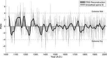
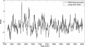
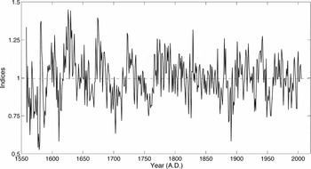
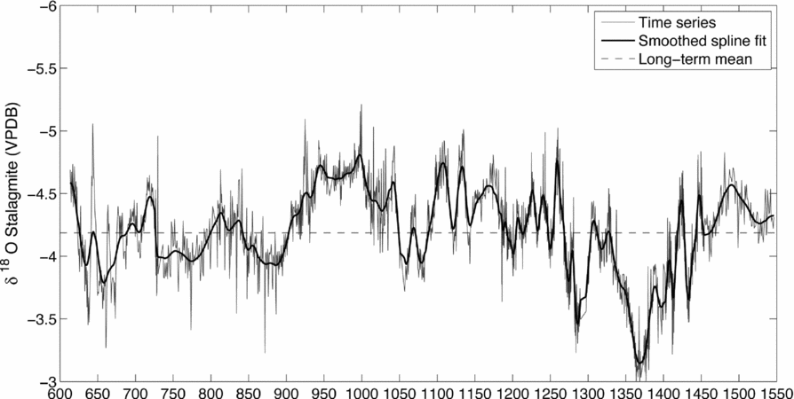
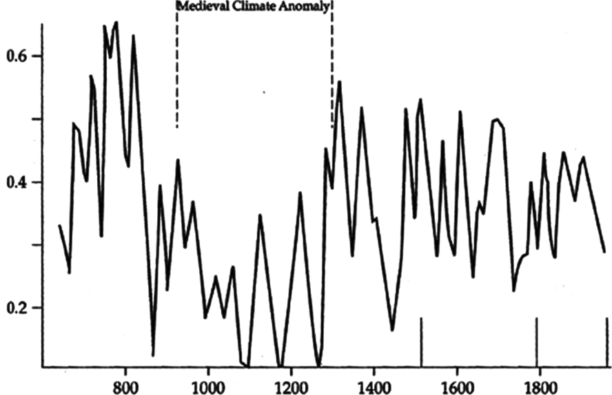
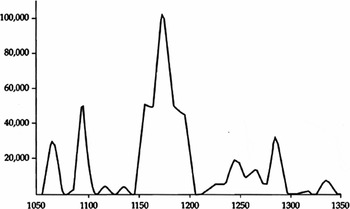
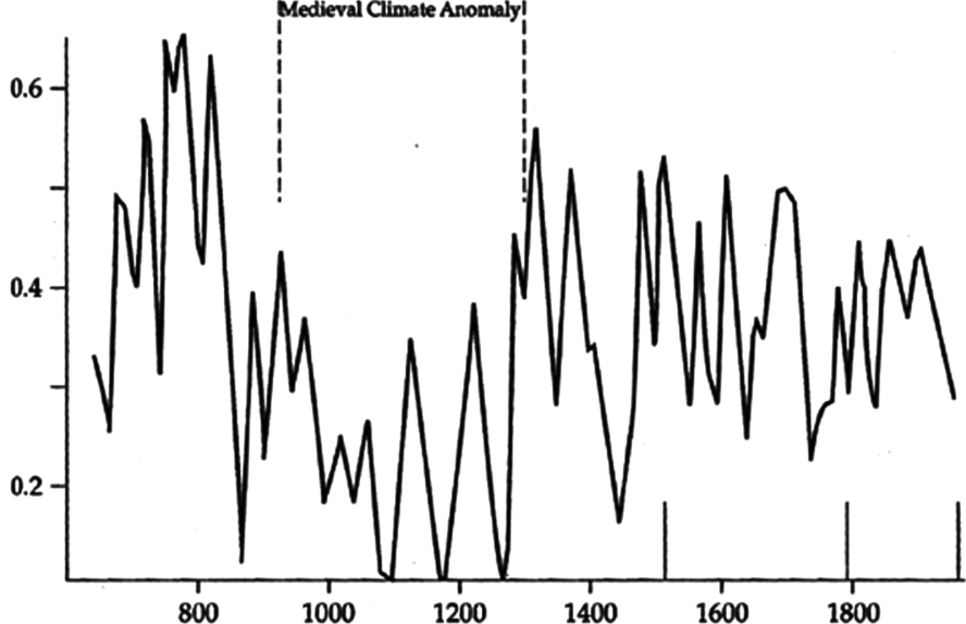
The following graphs record the combined impact on mainland hydroclimate of solar radiation, volcanism, and the El Niño Southern Oscillation as recorded in the above studies of southern and northern Vietnamese cypresses—captured in Figures 1 and 2, respectively—and of Thai teak in Figure 3. Rainfall values in Figures 1 and 2 are expressed in terms of the Palmer Drought Severity Index (PDSI), while Figure 3 records tree-ring widths as a proxy for rainfall.Footnote 17Figure 4 offers corroborating data based on speleothem calcite, i.e. stalagmite, records from Dandak Cave in east central India's core monsoon area.Footnote 18Figure 5 provides a composite time series for El Niño events over 1400 years, showing a marked reduction in such events during the Medieval Climate Anomaly.
Precipitation in southern Vietnam, measured according to the Palmer Drought Severity Index (PDSI), as reconstructed from tree-ring-widths of cypress trees (Fokienia hodginsii) growing in the highlands of Vietnam's Bidoup Nui Ba National Park. The higher the PDSI reading, the higher the annual rainfall. Although the sample size prior to 1250 is smaller than after 1250, the overall trend and multidecadal structure of the reconstruction imply far wetter than average conditions throughout key portions of the Medieval Warm Period, consistent with La Niña-like base state conditions.Footnote 19

Precipitation in northern Vietnam, measured according to the Palmer Drought Severity Index (PDSI), as reconstructed from tree-ring-widths of cypress trees (Fokienia hodginsii) growing in the Mu Cang Chai area of Vietnam. The higher the PDSI reading, the higher the annual rainfall.Footnote 20

Teak tree-ring widths, as a proxy for rainfall, from Mae Hong Son, Thailand. The wider the tree-ring, the higher the annual rainfall.Footnote 21

Stalagmite records, as a proxy for rainfall, from Dandak Cave in east central India. The left vertical axis shows the isotopic weight of precipitating rainwater, which correlates positively to precipitation. The right vertical axis shows precipitation as a percentage deviation from the twentieth-century mean, with droughts indicated by negative values.Footnote 22
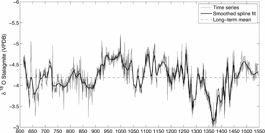
Composite time series for recurrence of El Niño events since 622 CE. Vertical axis represents events per year.Footnote 23
The charter era on the mainland, circa 950–1250/1300
How, then, did climate influence Southeast Asian political and economic development? Its earliest documented and arguably most sustained impact came during the charter era, circa 950–1250/1300.
Pagan, Angkor, and Dai Viet were all ‘charter states’ in the sense that each realm, as the earliest extensive indigenous polity in its area, provided a political, territorial, and high cultural charter for subsequent generations. All three flourished from the tenth to the thirteenth centuries—during the Medieval Climate Anomaly—and all three collapsed between 1280 and 1400, during the transition into the Little Ice Age.
The genesis of these polities was not tightly coordinated. As early as 802 Jayavarman II united (albeit temporarily) the Khmer lands, and by the early 900s Khmer civilization, centred at Angkor, boasted its defining features, including monumental temple construction and elaborate hydraulic works.Footnote 24 By contrast, although Upper Burma also supported irrigation and urban structures of some antiquity, not until the eleventh century did Pagan transform its system of autonomous city-states into a centralized kingdom, thus recalling Jayavarman II's ambition some 200 years earlier.Footnote 25 A Chinese province for most of the first millennium and independent only from 939, the northern Vietnamese area that would become known as Dai Viet also failed to support a stable indigenous polity until the early eleventh century.Footnote 26
Given these staggered starting points, remarkable indeed was the subsequent convergence of the charter states. Beginning with Rajendravarman (r. 944–968), whose reign is said to have constituted ‘one of the major discontinuities’ of Khmer history,Footnote 27 and continuing through to the early 1200s, several interlinked developments at Angkor point to a novel phase. Notwithstanding Jayavarman II's early aspirations, not until the tenth century did the notion of a unified Khmer polity gain stable expression. After 890, and more especially 1000, hydraulic and religious construction assumed an unprecedented scale, with the vast Eastern, Western, and Northern Barays (reservoirs) supplementing or replacing earlier water storage facilities and with twelfth-century Angkor Wat becoming the largest religious monument of all time.Footnote 28 Angkor's core population, perhaps 750,000 at its peak around 1200, also came to constitute what has been termed the ‘largest low density urban complex in the preindustrial world’.Footnote 29 Khmer frontier colonization rolled north and west of the Great Lake heartland, and imperial authority spread over much of modern Thailand, Laos, and south Vietnam.Footnote 30
In this same period (950–1250), Pagan exhibited a comparable leap in organizational complexity. The Burmans’ earliest agrarian projects focused on rice irrigation in the Kyaukse basin, northeast of Pagan, and in Minbu, to the south. After these ‘hubs’ (hkayaings) had been developed, with population pressing on available resources, in the twelfth century Burmans moved into frontier regions (taiks) west of the Irrawaddy. Insofar as Buddhist temple-monasteries, like their Khmer counterparts, helped to spearhead reclamation, temple endowments and cultivation moved more or less in tandem. Both phenomena grew slowly into the late eleventh century, accelerated with the opening of taik lands in the twelfth century—the same century as gave birth to Angkor Wat—and continued at elevated, if diminished, levels to about 1300. Together, hkayaing intensification and taik extension reflected and permitted substantial population growth. In turn rising aggregate and possibly per capita wealth encouraged commercial exchange and political integration within the Upper Burma core, and military expansion north to Bhamo, west into Arakan, and south into Lower Burma.Footnote 31
In what is now northern Vietnam, village records and family genealogies point to intensified movement after the tenth century from hilly areas of the Red River basin north and west of the capital into deltaic and coastal regions to the south and east. Taming the delta through polders and dikes was more taxing than cultivating the foothills, but potentially more rewarding insofar as more abundant water and more fertile soils facilitated multiple cropping. Between 1000 and 1300, and especially during the thirteenth century, the polder network expanded; new or extended dikes rechanneled the Red, Thai Binh, Ma, and Chu Rivers, whilst coastal barriers to tides and typhoons facilitated reclamation of extensive silt basins. Accordingly, the population in northern Vietnam grew from an estimated 1,600,000 in 1000 to 3,000,000 in 1300.Footnote 32
In summation, if political and institutional development at Angkor preceded that at Pagan and Dai Viet and if (on present evidence) the Vietnamese economy in the late thirteenth century showed somewhat greater vitality than its Khmer or Upper Burmese counterparts, for most of the period between 950 and 1300 all three realms saw a dramatic increase in cultivation and population and an elaboration of imperial institutions.
Idiosyncratic local factors independent of climate surely influenced the timing of these expansions. In the Irrawaddy basin, for example, if we accept that ethnic Burmans entered in force only in the mid 800s,Footnote 33 and if we credit Richard O'Connor's theory that the Burman water-control techniques were superior to those of earlier residents,Footnote 34 we may have a partial explanation for the rather gradual nature of agrarian expansion and the relatively late date of political integration under Pagan.Footnote 35 In northern Vietnam, Tang collapse in the early 900s drew the local elite into a tumultuous competition whose resolution under the early Ly Dynasty (1009–1225) was a precondition for political and probably economic maturation. Adaptation of Chinese-style hydraulic administration under the early Tran Dynasty (1224–1400) enhanced Dai Viet's agrarian prospects quite substantially.Footnote 36
But if local features help to explain early differences, they say nothing about the far more basic question: Why, amidst local variations, did all three charter states flourish between circa 950 and 1250/1300? Why do we not find charter geneses randomly distributed between, say, the fifth and fifteenth centuries? The problem is all the more intriguing in that China, South Asia, and Europe also enjoyed generally unprecedented economic, demographic, and political vigour for much of the period between 950 and 1250/1300.Footnote 37
The most obvious common factor in the Cambodian plain and the Irrawaddy basin was Indian maritime contacts, which provided a template for royal courts and temples. But this avails us little insofar as Saivite and/or Buddhist elements had been integral to both mainland cultures since at least the seventh century, while in Dai Viet, Indic influences remained marginal. Some best practices in agrarian technique and seed selection probably spread across the mainland either overland or, more probably, along the coast. But again why should diffusion have intensified after 950? Of yet wider significance, burgeoning trade with China and South Asia after 900 may have helped to coordinate mainland growth in three ways: (1) overseas demand encouraged specialized export crops (albeit on a yet modest scale);Footnote 38 (2) conceivably, more frequent trade contacts joined population growth to transform once uniformly lethal epidemic diseases like smallpox into endemic afflictions of childhood. By precluding the horrendous virgin-soil effects associated with smallpox in the New World, this would have benefited those coastal and lowland districts where populations were sufficiently dense to sustain chains of infection and where exposure to foreign pathogens was most common;Footnote 39 (3) more certainly, prestigious foreign goods gave charter states incentivesFootnote 40 and cash revenuesFootnote 41 to support agrarian expansion.
While working in synergy with these other factors, however, climate may have been the single most influential agency of charter coordination. As Figure 1 indicates, after a strong desiccative phase between 1040 and 1090, the twelfth century saw a dramatic, possibly unprecedented increase in rainfall, with the highest PDSI values on record. The thirteenth century then divided between an unusually dry first half (note, however, that pre-1250 readings are the least reliably replicated portion of the record) and an unusually wet second half. Average PDSI values between 1030 and 1300 exceeded those for any comparable period to 1900. These post-1030 trends are broadly consistent with records from Dandak Cave in east-central India (Figure 4) as well as with speleothem readings from Wanxiang Cave in North China.Footnote 42 Moreover, although the south Vietnamese cypress series starts only in 1030, Indian, Chinese, and European records and theoretical studies indicate that the Medieval Climate Anomaly as a whole, circa 900/950-1250/1300, (a) tended to be unusually warm, (b) saw the Inter-tropical Convergence Zone stabilize some five degrees latitude north of its post-Medieval Climate Anomaly location, and (c) may have produced a persistent La Niña-like condition in the tropical Pacific.Footnote 43 Historically all three conditions have been associated with increased rainfall over Southeast Asia and India. Persistent La Niñas tend to produce not merely an increase in monsoon volume, but more even annual distribution, with longer monsoons, shorter dry season droughts, and fewer deluges that can damage crops and irrigation works. Thus rain becomes available in more ‘usable’ form over a longer part of the year. All in all, these would have been ideal conditions for agricultural and political expansion, especially in those ‘rain-shadow’ dry zones, partially shielded from the monsoons by southwestern uplands, where both Pagan and Angkor lay.
Without Southeast Asian data prior to 1030 we cannot prove that the Medieval Climate Anomaly helped to ‘jump start’ charter state expansion. But given that the Dandak Cave materials (Figure 4) show extremely strong monsoons between 950 and 1030, and given the long-term correlations between Dandak and southern Vietnamese cypress data (Figures 1 and 4), it is reasonable to assume that climatic amelioration between 950 and 1030 contributed significantly, even critically, to early charter vitality across the mainland. That assumption is strengthened by the fact that our earliest currently available mainland PDSI reading, from 1030, is at a very high level (Figure 1).
After 1030 climate's contribution to charter construction is more easily demonstrated. At Pagan, Figure 6 (based on work by Bob Hudson, Nyein Lwin, and Win Maung) charts the volume of material used in religious construction between 1050 and 1350. Note that during the twelfth century, a period of greatly enhanced rainfall, building rose sharply. Given the ‘ideal’ climate between 1100 and 1150, one would expect a more rapid increase than has been detected. Perhaps excessive rain impeded brick construction, perhaps some edifice dates are problematic, perhaps political conditions were unfavourable. But the overall vigour of twelfth century construction remains stunning. Slow growth during the first third of the thirteenth century and renewed expansion from around 1230–1300 also are consistent with climatic trends, although as we shall see below, ecology and politics as well as rainfall began to impose a ceiling on fresh dedications. Insofar as Buddhist wealth derived principally from landed endowments, whose opening depended heavily on climate, it is hardly surprising that reclamation also correlated broadly to rainfall. Irrigation in the ‘hubs’ (hkayaings) of Kyaukse and Minbu, on which initial efforts focused, relied on streams that would have benefited from enhanced monsoons between 950 and 1040. Developed in the twelfth and thirteenth centuries, taik districts in Shwebo, Lower Chindwin and Pakokku lacked the same level of perennial irrigation as the ‘hubs’. Yet in these frontier areas the exceptional pluviation of these two centuries would have favoured rain-fed wet rice as well as dry crops. In contrast to religious construction, Burmese land reclamation between 1100 and 1150 remained vigorous.Footnote 45
Religious donations at Pagan, showing cubic meters of building material used in 89 epigraphically or historically dated monuments.Footnote 44

In Cambodia improved rainfall during the latter part of Angkor's eighth to tenth-century genesis may have helped farmers move from easily cleared but comparatively unproductive sites in the Mekong delta and the Mun-Chi River floodplains, towards wooded lowlands in the same river basins and around the Great Lake. In this normally arid regionFootnote 46 cultivators dug ponds and enclosed hundreds of thousands of small, bunded rice fields. Under royal direction they also developed an ever more elaborate network of reservoirs, canals, moats, and irrigation channels so as to harness both the monsoons and streams dependent on the monsoons. By capturing water for release during the dry season and periods of drought, by diverting excess water to the Great Lake, and by helping to sustain a year-round high water table, these facilities, capped by the great royal barays, helped to stabilize production. They thus contributed to that vast expansion in population and religious infrastructure that defined classical Angkor. What is more, strong eleventh and twelfth-century monsoons can only have aided Khmer colonization of northeast modern Thailand, which, like Burmese taiks, was relatively arid. Although we lack construction profiles comparable to those for Pagan, it is worth noting that Angkor Wat, Angkor's most lavish structure, arose in those very decades, between 1120 and 1150, that saw the most intense and ‘usable’ rainfall during the entire second millennium, and that by 1200, after a century of ideal pluviation, the number of temples in Angkor's extended core peaked at 3000 to 3500.Footnote 47
To argue that improved monsoons helped Pagan and Angkor, both located in dry zones, is not difficult. But in so watery an environment as the Red River delta, where Dai Viet was centred, would not increased rainfall have been an unwelcome impediment? In fact, those who reclaimed the delta came from upland areas with limited agrarian potential that would have benefited from wetter conditions. Delta colonization under both the Ly and Tran Dynasties drew in part on communities in higher elevations like Bac Giang, Thai Nguyen, Phu Tho, and Hoa Binh, where fifth- and even tenth-month rice crops remained vulnerable to drought. By reducing famine mortality and enhancing natality, more reliable rain-fed harvests in hilly areas may have helped to create the demographic pressure that impelled delta reclamation in the first place, whilst providing the extra manpower needed for polder construction to succeed.Footnote 48 Moreover, if we extrapolate from the nearby Pearl River basin, whose hilly topography resembles that of the Red River, from the twelfth to the early fourteenth centuries population pressure and slash-and-burn agriculture in the hills aggravated erosion, which increased the downstream flow of silt to support polders in areas like Thai Binh province, much of which was reclaimed from the sea and salt marsh.Footnote 49
Furthermore, in all three realms climatically assisted population growth not only increased the charter state's military and tax base, but in autocatalytic fashion, may have hastened the domestication of smallpox by creating local chains of infection sufficient to shift that disease from epidemic to endemic status. Likewise, by enhancing local demand for foreign imports and local provision of maritime exports, lowland economic growth may have stimulated trade with China and India, with its attendant cultural and material spurs to state formation.Footnote 50
Finally, although space precludes adequate consideration, the thesis of Medieval Climate Anomaly stimulus to charter expansion between circa 950 and 1250/1300 gains credibility from studies showing that, in this same period, warmer climate—whether by substantially extending the growing season or by increasing monsoon flows—contributed to the unprecedented agrarian and political vitality of Kiev, of the West European high middle ages, of Song China, and of warrior-led polities across South Asia. Expanding multilateral trade across Eurasia, both overland and by sea, was in large part a symptom of this generalized prosperity.Footnote 51
Charter state collapse, circa 1250/1300–1450
After centuries of growth, all three charter realms came under mounting internal and external pressures. In the second half of the fourteenth century these culminated in a generalized economic, political, and in some cases cultural collapse, an era of fragmentation and disorder, that contrasted sharply with the integrative thrust of the charter epoch.
To sketch briefly these events: The Upper Burma state, centred originally at Pagan, faced Mongol invasions after 1277, revolts in Lower Burma from 1287, and calamitous Shan invasions from the northern hills that climaxed between 1359–1368. (Shans were one branch of the great Tai ethno-linguistic family that includes Lao, Siamese, and Yuan.) Thereafter the western mainland—which, even in Pagan's heyday, held a plethora of encapsulated ethnicities—remained split between an upland zone of petty Shan states, a new Burman-dominated dry zone kingdom of Ava, and a coastal kingdom led by people of Mon ethnicity.Footnote 52
In the central mainland, Angkor lost control of its western satellites in the mid and late 1200s, after which Tai attacks from the west forced the political abandonment of Angkor itself, temporarily, it would seem, at some point between 1350 and 1389, and permanently by 1450. The central mainland thus fragmented between a rump Khmer state and a medley of Tai-led kingdoms to the west and north, among which Chiang Mai in the Ping basin, Sukhothai in the piedmont, Lan Sang in modern Laos, and Ayudhya near the coast proved pre-eminent. These geopolitical shifts were accompanied by the retreat of Angkorian high culture, as Sanskritic Hinduism yielded to Tai-mediated Theravada Buddhism, as the building of stone temples ceased, and Tai language and culture began to overshadow Khmer.Footnote 53
Because Tais failed to penetrate the Vietnamese lowlands and because Dai Viet was more ethnically uniform, hence less fissiparous, than Pagan or Angkor, post-charter cultural displacements were less pronounced. Yet Dai Viet also faced something of an existential crisis, as peasant distress sparked massive uprisings from the 1340s, and Dai Viet's southern neighbour, Champa, launched raids into the Vietnamese heartland between 1361 and 1390 that destroyed the Tran Dynasty. Together, emigration, famine, disease, and Cham attacks may have slashed Dai Viet's population from around 3,000,000 in 1300 to barely half that a century later.Footnote 54
How shall we explain these generalized disorders? In part, they reflected longstanding institutional weaknesses, including the ability of the elite to wring concessions from rulers who depended on them for accession or religious validation. In the late Pagan period, for example, successful candidates for the throne often felt obliged to reward supporters with land grants and to countenance the conversion of royal freemen into private bondsmen. To secure political support and to acquire merit for happy reincarnations, Pagan's rulers also patronized (and allowed others to patronize) the Buddhist monkhood with permanent endowments until by 1280 the monkhood owned one to two-thirds of cultivable land, all of it tax-free.Footnote 55 At Angkor as well, where successions were normally contested, politically indebted kings conferred tax-exempt acreages on aristocratic supporters, whose religious munificence began to rival that of the throne. Here, too, long term efforts to reclaim tax-free lands from aristocratic families and temples were only partly successful.Footnote 56 Similarly in Dai Viet, Mongol attacks ended Sinic bureaucratic experiments in favour of a more patrimonial system in which military princes built private estates tilled by servile labourers many of whom had left village tax-rolls. In all three instances, once royal authority in the core was impaired, the empire quickly unravelled, for these were ‘solar polities’ in which a central sun held in unsteady orbit planets, i.e., provinces, whose autonomy tended to increase with distance. Apart from ceremonial ties and the ever less credible threat of military chastisement, in Pagan and Angkor, in particular, there was no way to ensure the loyalty of formerly independent kingdoms, whose rulers often aped the ritual claims of the capital.Footnote 57
In each imperial core cumulative ecological stress, itself partly a function of Medieval Climate Anomaly vitality, hastened political devolution. In the heartland of Upper Burma the most critical resource was never land per se, rather irrigable land. But by the mid 1200s a pronounced reduction in donations suggests that reclamation already had reached or was approaching the limit of available water resources.Footnote 58 As the population continued to grow, the declining quantity and quality of per capita arable led more impoverished freemen to seek security as bondsmen on religious and lay estates. If this offered immediate benefits to some estate owners, in the long term peasant immiseration reduced the surplus and intensified intra-elite factionalism.
Resource limitations were at least as debilitating at Angkor, albeit with a peculiar twist focusing on the unusually elaborate hydraulic system. If some aspects of his thesis remain controversial,Footnote 59 paleoecologists and archaeologists have now confirmed much of Bernard Groslier's bold hypothesis, advanced over 35 years ago, that Angkor fell victim to ecological strains.Footnote 60 In the eleventh and twelfth centuries, as the search for fuel, building materials, and perhaps fresh arable land pushed peasants to clear forests ever farther north of Angkor in the Kulen hills, erosion and sedimentation began clogging streams and canals connected to the royal barays. Although these reservoirs supplied primary irrigation to only a small portion of Angkor's rice fields, they helped to stabilize overall production, as noted, by blunting seasonal floods, by providing water in the dry season and during droughts, and by sustaining a year-round high water table necessary for wells, ponds, and canals. As repeated breaches and only partly successful repairs suggest, erosion, sedimentation, and the sheer difficulty of maintaining an ever more convoluted system began to impede all three functions, even in Angkor's heyday. By the early 1200s the West Baray, for example, was going dry.Footnote 61 What is more, accumulating phosphates from human and animal waste may have joined lakeside deforestation to impair those lake fisheries that supplied Angkor's population with its chief source of protein.Footnote 62 As in Upper Burma, such pressures apparently began to reduce settlement and population,Footnote 63 to intensify factionalism, and thus to leave the realm vulnerable to Tai incursions.
Dai Viet too suffered cumulative resource constraints. In the late 1200s, by which time, recall, the population was almost twice that of 1000, new tracts became more marginal and reclamation began to stall. This slowdown joined land engrossment by princes and other notables to depress peasant income, which not only accelerated the transformation of taxpayers into servile labourers, but as the annals show, from 1343 prompted repeated uprisings by starving vagabonds and monks championing such slogans as ‘Relieve the impoverished people’.Footnote 64
In short, in one locale after another some 300 years of growth began to produce, if not Malthusian crises per se (more equitable land distribution probably would have alleviated peasant distress), then severe political and ecological strains. Reduced temple construction at Pagan, deforestation of the Kulen Hills and hydraulic difficulties at Angkor, peasant distress in Dai Viet, and sputtering reclamation in all three realms attested to the ecological dimension. In all three realms internal debility naturally encouraged—and was exacerbated by—provincial defections and external attacks. Indeed, insofar as major provinces retained traditions of independent sovereignty, the distinction between external attacks and imperial defections could be quite nominal. The pronounced localism of ethnic and religious identities—an inevitable by-product of popular illiteracy and weak market and political linkages—further inhibited capital-centred loyalties such as we shall find helped to stabilize post-charter realms.
But why across the mainland did institutional and ecological strains that had been building for some time become acute in the third quarter of the fourteenth century? What seems to have converted still manageable tensions into uncontrolled crises was the aforementioned transition from the Medieval Climate Anomaly to the Little Ice Age. By dragging the Inter-tropical Convergence Zone five degrees of latitude south (where it remained until the latter half of the nineteenth century), the Little Ice Age helped to diminish the geographic reach of summer monsoons. If a La Niña-like base-state in the tropical Pacific characterized the Medieval Climate Anomaly, the Little Ice Age may have been dominated by persistent El Niño conditions. Thus, whereas the Medieval Climate Anomaly had produced decidedly above average monsoon volume, during the Little Ice Age droughts became far more frequent and prolonged.Footnote 65 As Figure 1 shows, rainfall diminished notably in the early 1200s, improved after 1250, but declined sharply in the fourteenth century, reaching a low point around 1340–1380—the very years that saw major invasions and/or domestic upheavals in Burma, Dai Viet, and Angkor. In each realm it was these mid and late fourteenth century disturbances—Shan invasions in Upper Burma, Tai invasions and the first putative abandonment of Angkor, peasant revolts and Cham invasions in Dai Viet—that effectively terminated the charter era. After a brief respite, desiccation resumed for most of the period from circa 1390–1450 and from circa 1470–1490. All in all, of the 40 most negative annual PDSI scores in the 1000-year long south Vietnamese cypress record, six fell in the mid and late 1300s and seven in the early 1400s. In much of monsoon Asia a mere 10 per cent reduction in seasonal rainfall is sufficient to trigger a major drought, but in the fourteenth century these so-called Angkor Droughts may have seen a 20–30 per cent reduction (relative to the modern climatological mean) and lasted 30–40 years.Footnote 66 These tree-ring patterns are consistent with speleothem records from India and North China and with chronicle notices of severe drought from north eastern Burma, northern Thailand, and northern Vietnam.Footnote 67
Not only did the volume of the monsoons diminish for long periods, but new distribution patterns may have rendered such rains as did fall less accessible. The Medieval Climate Anomaly, we saw, was characterized by relatively gentle monsoons spread across a substantial part of the year, with limited dry season droughts, conditions that may have favoured double-cropping. In contrast, Little Ice Age monsoons probably were more volatile and more concentrated in short annual periods with high magnitude deluges. Thus northern Burma, northern Thailand, northern Vietnam, and Cambodia saw droughts broken by occasional freak floods from the 1290s to the late 1300s and in the first half of the fifteenth century.Footnote 68
Such conditions would have eroded royal legitimacy—since the ruler was responsible for maintaining cosmic harmony—whilst shifting power to more hydrologically secure districts. In Upper Burma the transfer of the royal capital from Pagan to Myinsaing, Pinya, Sagaing, and finally to Ava (1365) may have owed much to the fact that the latter four sites all lay closer than Pagan to perennially irrigated Kyaukse. Subsequently on the southern fringes of the dry zone, better watered districts like Prome and Toungoo began to enhance their authority at Ava's expense; and within the lowlands as a whole, Lower Burma, with average annual rainfall over three times higher than in the dry zone, achieved a novel pre-eminence. Indeed, the new Mon-led Lower Burma kingdom of Ra-manya, whose capital would settle at Pegu, detached the entire south from Upper Burma's authority.Footnote 69
At Angkor, the combination of recurrent drought and episodic deluge proved particularly damaging to the fragile hydraulic infrastructure, which, as we saw, in the early 1200s already was working at reduced capacity. Between circa1290 and 1340 severe floods cascaded through the system, inflicting what seems to have been irreparable damage, whilst droughts in the fourteenth and fifteenth centuries reduced further the system's basic supply.Footnote 70
To repeat, tensions rooted partly in Medieval Climate Anomaly growth had been present for decades, but now across the mainland climate intensified and synchronized those strains to the point of undisguised rupture. Traditionally scholars have explained the ‘fall’ of Pagan, Angkor, and Dai Viet by focusing on local, sui generis politics and institutions. Now climate, for the first time, helps to provide a coherent regional narrative.
To the direct impact of climate, however, we must add two other mechanisms of coordinated collapse: Tai incursions and maritime trade. Both were influenced by climate, although neither can be reduced to a function of climate.
Moving south and west from what are now South China and northern Laos, in the eleventh century illiterate Tai ‘valley wanderers’ entered the orbit of Pagan and Angkor as mercenaries and low-level tributaries. Four factors now allowed some of these groups to exploit charter state debility with dramatic success.Footnote 71 First, Tais enjoyed martial skills typical of rough-hewn frontiersmen. Second, Tai statelets benefited in the late 1200s from Mongol patronage and from Mongol pressure on Pagan, Angkor, and Nan-zhao (in Yunnan). Third, Tais apparently enjoyed superior agricultural techniques. Not only did they disseminate productive new rice strains, but O'Connor argues that upland water management skills let them (like Burmans in an earlier age) occupy a range of niches beyond the flood-land edge where previous cultivators had dwelled.Footnote 72 The superiority of this agrarian complex led many non-Tais to accept the newcomers’ language and social conventions, in effect, to become Tais, thereby swelling Tai ranks more rapidly than natural growth alone would have done.Footnote 73 Finally, Tais probably benefited from the Medieval Climate Anomaly. On the one hand, during the ideal monsoon conditions of the twelfth and late thirteenth centuries proliferating Tai-lowland economic interactions provided Tai monks, traders, mercenaries, and chiefs with the cultural capital—Buddhist literacy, models of kingship—that was critical to rule sedentary populations. Not surprisingly, Tai states most familiar with charter civilizations proved best able to exploit post-1250 turmoil.Footnote 74 On the other hand, successful Tai kingdoms like Chiang Mai, Chiang Saen, Phayao, even Sukhothai lay in rain-shadow zones that profited from the unusual reach and duration of monsoons to circa 1300. Most such places could have flourished only under a climatic regime very different than that of today.
At the same time as Tai pressure weakened charter states from the interior, rising maritime trade prompted defections at the coast. Between circa 950 and 1280 in India, South China, Europe, and other sectors of Eurasia, benign conditions associated with the Medieval Climate Anomaly contributed to agrarian-cum-population growth, which in turn swelled the demand for foreign luxuries, hence the volume of east-west traffic passing through Southeast Asian waters.Footnote 75 Mainland ports that provided entrepôt services and exchanged forest exotica and other local specialties for imported handicrafts and metals thus increased their authority at the expense of interior centres. Between circa 1280 and 1400 some scholars claim that Eurasian population losses, the Mongol diversion of trade overland, and Ming restrictions depressed Southeast Asian maritime trade.Footnote 76 Others argue that Eurasian demographic decline had little impact on—indeed may have favoured—those luxury trades in which Southeast Asia specialized.Footnote 77 But even if the pessimists are right that trade fell in absolute terms, given the severity of Southeast Asia's post-1300 agrarian crises, in the fourteenth century the relative contribution of maritime commerce to regional political economies almost certainly increased. What is more, the mid fifteenth century inaugurated a vigorous maritime expansion.
In synergy with climate and Tai attacks, maritime defections thus became a key element in charter collapse. Trade probably contributed more substantially than agriculture to the growing power of Ra-manya in Lower Burma, whose agrarian population actually seems to have been quite thin.Footnote 78 In the central mainland Angkor became the principal victim of this same maritime shift, while Suphanburi, Ayudhya, and Phnom Penh, all relatively near the sea, were amongst the main winners.Footnote 79 In the eastern lowlands as well, Champa benefited in the late 1300s from the tendency of Chinese shipping to bypass northern Vietnam in favour of the Cham coast, which specialized in rare forest products.Footnote 80
We note in passing that the Medieval Climate Anomaly–Little Ice Age transition also contributed to fourteenth-century crises in Europe, China, and India. The same decades (1340–1380) as collapsed Upper Burma, Angkor, and Dai Viet saw the nadir of French fortunes during the Hundred Years War, the fall of the Yuan Dynasty, and the effective collapse of the Delhi Sultanate. In each case climatic deterioration magnified in complex ways long-standing institutional and/or ecological vulnerabilities.Footnote 81
Climate and political reintegration, circa 1450–1610
During the ‘early modern’ era of mainland history, circa 1450–1820, climate remained influential, but less so than during the previous five centuries. As our introduction and Figures 1 to 3 suggest, after about 1450, with the partial exception of the eighteenth century, multidecadal rainfall fluctuations became less pronounced than during the Medieval Climate Anomaly and the early Little Ice Age. Moreover, multiple forces—economic intensification and diversification, firearms, institutional refinements, wider cultural circulation—sheltered post-1450 states and societies more effectively against dislocation. Thus, whereas climate continued to oscillate, in all three sectors of the mainland, political and cultural integration tended to progress in more or less linear fashion.
Consider first the period circa 1450–1610, whose coherence derived from the fact that in each sector these years saw the first sustained post-charter political revival. In each sector, moreover, post-charter experiments ended in the late 1500s with a second generalized collapse, albeit in the west and centre a collapse far shorter and less disruptive than that which closed the charter era.
Lieberman's claims for improved climate between circa 1470 and 1590 now may be seen as overstated,Footnote 82 because although conditions ameliorated, by and large the desiccation characteristic of the early Little Ice Age persisted. In the western and central mainland this continued to privilege well-watered districts along the perimeter of the old charter empires at the expense of their dry-zone cores.
Thus in the Irrawaddy basin low rainfall continued to weaken the interior, where Ava had succeeded to Pagan's authority, to the benefit of the coast and newly risen principalities along the southern fringes of the dry zone midway between Ava and the coast. In the latter districts the aforementioned states of Prome and Toungoo expanded tanks and feeder canals and benefited from a more productive, water-intensive rice strain known as kauk-gyi. Lying outside the charter heartland where land had been alienated to religion for 400 years, these southern principalities also faced fewer monastic claims to tax exemption than did Pagan or Ava. As a beneficiary of ecological realignment, as the chief refuge of Burmans fleeing disorders in the north, and as proud heir to Burman (as opposed to Mon or Shan) ethnic traditions, Toungoo emerged as the strongest state in the western mainland, conquering Lower Burma in 1539 and the entire western mainland by 1558. After taking Lower Burma, rulers of the so-called First Toungoo Dynasty (1486–1599) moved their capital to Pegu, near the coast, which besides being a major port, lay in a rice surplus area favoured by both rainfall and riverine overflow. First Toungoo kings would remain at Pegu until their dynasty fell at the close of the sixteenth century. In short, in the western mainland between 1450 and 1600 Little Ice Age climate helped—we shall emphasize shortly the limits to that contribution—to pull the political centre of gravity ever farther south.Footnote 83
A similar pattern characterized the central mainland, with Ayudhya near the coast playing the role of Toungoo and Pegu, and with Angkor and interior Tai kingdoms playing the part of Burmese dry zone centres. Founded circa 1351 near the frontier of the old Angkorian empire at the southernmost habitable extension of the Chaophraya basin, Ayudhya (capital of the future Siam) controlled what became the central mainland's most productive agrarian sector. In the lower Chaophraya basin, where rainfall was supplemented by alluvial floods from five major rivers, excess, not dearth, was the chief hydrological problem. Given the development of floating rice in the deep-water belt below Ayudhya and the suitability of the delta north of Ayudhya for high-yield rice strains similar to Burmese kauk-gyi, cultivation around Ayudhya was capable of considerable extension. By 1400, the Little Ice Age had helped to destroy Angkor's hydraulic system. Nor in the long term could new Tai centres in what is now north-central Thailand rival Ayudhya, in part because Little Ice Age desiccation rendered their agrarian base ever more inadequate. Although Chiang Mai, for example, called itself ‘A Million Ricefields’ (Lan Na), in fact it lay in a constricted basin that received only 75 per cent as much rainfall as Ayudhya and that lacked the same bountiful enrichment from annual floods.Footnote 84
Between 1378 and 1523 Ayudhya triumphed over interior Tai states in bitter contests to control export staples and population clusters on the northern fringe of the central plain. Ayudhya also forced Cambodia on the defensive, notwithstanding the southward shift of the Khmer capital to the Phnom Penh area. Thus Ayudhya became the new regional hegemon. These triumphs joined population growth, wider monastic education, and market linkages to meld from Tai, Khmer, and Mon elements a novel Siamese ethnicity, which afforded Ayudhya's realm a growing psychological and cultural solidity.Footnote 85
As the western and central mainland began to cohere under Toungoo/Pegu and Ayudhya, respectively, a revived Dai Viet unified most of the eastern littoral. In 1471 the new Lê Dynasty (1428–1788) effectively destroyed its proud southern rival, Champa, opening formerly Cham areas to Vietnamese settlement. Accelerating from the mid 1500s, Vietnamese colonization drew strength from a remarkable demographic recovery. Between 1417 and 1539 northern Vietnam's registered population rose from 1,862,000 to 5,625,000. Although it is unclear to what extent this increase reflected improved registration, as opposed to actual population growth, Li Tana is certain that population by 1540 easily surpassed its charter-era peak, providing the land-hungry recruits needed to ‘open the mountains and cut through the rocks’ of the southern frontier, as the saying went.Footnote 86
In Vietnam, however, climate's contribution to political integration was weaker than in the western or central mainland, where, we just argued, desiccation helped to drain power to well watered coastal districts. True, along the eastern littoral as well, migration proceeded from northern Vietnam to normally wetter territories farther south. Yet whereas everywhere else charter heartlands languished after 1450, in the east it was precisely Dai Viet's ancient core that was most demographically and politically vital. Admittedly, too, between circa 1490 and 1600 tree-rings suggest that rainfall became heavier in northern Vietnam than elsewhere on the mainland.Footnote 87 But by itself this upturn seems far too modest to explain Dai Viet's remarkable late fifteenth and sixteenth-century vigour.Footnote 88
What influences other than climate, then, were at work?Footnote 89 Vietnamese merchants and artisans profited from expanding maritime trade, particularly with China. More basic, from 1427, Vietnam enjoyed almost a century of peace. Villages beyond the polder cores had been the first to empty out during the turmoil of the fourteenth century. Now, with more settled conditions, peasants not only reoccupied those sites, but resumed their push into virgin lands. Having embraced quasi-bureaucratic Ming administrative models, the new Lê Dynasty promoted reclamation and provided a military shield behind which colonization could proceed. Lê infantry deployed Chinese-style firearms to good effect. But if multifaceted Sinic-style state strengthening favoured agrarian expansion, the reverse was also true. Economic growth swelled the government's tax base and, by supporting wealthy peasants and modest landowners, provided a social foundation for the anti-aristocratic Neo-Confucian revolution of the fifteenth and sixteenth centuries. Along with wider literacy, market integration, and state patronage, such developments recast Vietnamese ethnicity and disseminated elite cultural and social norms vertically as well as horizontally.
In the western and central mainland, too, although climate influenced agrarian productivity more obviously than it did in Vietnam, we would emphasize that it was but one of several spurs to coastal ascendancy—and not necessarily the most critical. Indeed, despite Lower Burma's military eclat, for most of the sixteenth century Lower Burma's demographic/agrarian base probably remained inferior to that of the dry zone. In addition to the Little Ice Age climate, Toungoo Burma and early Ayudhya owed their success to factors that, in distinct local permutations, recall Vietnam's expansion between 1450 and 1600.
First were maritime contacts. Lubricated by Japanese and New World silver, and responding to vigorous demands from Europe, China, South Asia, and Japan, Southeast Asian commerce rose sharply between 1450 and 1620. In essence, their monopoly position athwart riverine outlets enabled Pegu and Ayudhya to dictate terms of trade to multiple interior centres.Footnote 90 From the 1520s coastal trade also gave ports a monopoly on European firearms, reminiscent of Chinese weapons in Vietnam, which played a major role in unification wars. In other words, the same coastal areas that benefited from the Little Ice Age climate also benefited from trade and the arrival of guns—which makes isolating the effects of climate exceedingly difficult. Second, in the west and centre, as in Vietnam, recovery from antecedent disorders gradually enhanced each state's resource base. Third, again as in Vietnam, royal support for reclamation and trade reinforced local economic initiatives. Likewise, royal patronage joined new trade circuits and rising literacy to encourage ethnic and religious standardization, providing each state with a more secure cultural base. Finally, although Burma and Siam lacked administrative blueprints such as Vietnam had borrowed from Ming China, trial and error favoured critical improvements on charter-era administration, including novel curbs on religious wealth and institutions. In particular, facilitated by wider commercialization, a shift in religious donations from permanent tax-free lands to cash and handicrafts reduced the problem of monastic autonomy that had helped to cripple Pagan.Footnote 91
Nor can we accord climate the same primary responsibility for coordinated political breakdown across the mainland during the second half of the sixteenth century as during the late charter era. Coordination became striking indeed: in 1555 Ava, in 1558 Chiang Mai, in 1569 Ayudhya, in 1572 Lan Sang (Laos), and in 1599 Pegu all fell to invasions; whilst between circa 1540 and 1610 Vietnam endured what Li Tana terms ‘perhaps the longest period of disaster in [its] history’.Footnote 92
In some cases, it is true, climate probably contributed to these difficulties. In Figure 3, Thai tree-rings point to decidedly weak monsoons in the second half of the sixteenth century, whilst chronicles from Kengtung, Lower Burma, and northern Vietnam refer to politically destabilizing droughts and famines in 1574 and the 1590s.Footnote 93 Suggestive, too, were wretchedly destabilizing climates between 1584 and 1610 in western Europe, Russia, China, and India. In fact 1601 may have been the coldest summer in the northern hemisphere for 600 years.Footnote 94
And yet Figure 1 shows that late sixteenth-century PDSI average values, although low compared with the Medieval Climate Anomaly, were higher than between 1450 and 1550, when Toungoo/Pegu, Ayudhya, and the early Lê polity all displayed a lusty, adolescent vigour. What is more, in the north Vietnamese heartland between circa 1540 and 1610 political disorder coincided with rainfall heavier than found elsewhere on the mainland. None of this is compatible with a primarily, much less exclusively, drought-based explanation of late sixteenth-century regional turmoil.Footnote 95
Indeed, it seems best to regard synchronized late sixteenth-century upheavals as evidence not of economic difficulty, but of an excessive, ill-controlled vitality issuing from the above combination of rising maritime trade, firearms, agrarian expansion, state initiatives, and so forth. These forces fed a competitive process of consolidation all across the Indic mainland. Pegu simply proved itself the most successful player, and its stunning triumphs—first over the entire western mainland, then over Siam and most of the Tai world, including Laos—explain all instances of political collapse outside Dai Viet between 1555 and 1590.Footnote 96 Likewise, its string of victories notwithstanding, Pegu's fissiparous imperial structure reflected a weakness common to all Indic polities. That is to say, the same inability to prevent outlying dependencies from defecting to the enemy as crippled Ayudhya and other kingdoms in the face of Peguan assaults undermined Pegu itself once Ayudhya counter-attacked in the 1590s. Thus, uncontrolled ambition and woefully inadequate territorial controls brought all the Indic mainland to grief in a few short decades.
If Dai Viet's remote position shielded it from Peguan attack, Dai Viet too fell victim to its own success. Renewed population pressure in northern Vietnam, rapid expansion along the eastern corridor, and the absence of a unifying riverine artery best explain the civil wars which tore apart Dai Viet in the second half of the sixteenth century and which, in the seventeenth century, produced a sustained north-south split.Footnote 97
To summarize our findings for circa 1450–1610—Desiccation favoured coastal districts in the west and centre, but climate's contribution to economic and political vigour across the mainland seems to have been far weaker than during the Medieval Climate Anomaly. So too, climate's contribution to coordinated political collapse after circa 1550 was more limited than in the late charter era because: (a) climate in the sixteenth century oscillated less wildly, and may have been less geographically uniform, than in the thirteenth to fifteenth centuries; (b) whereas the three main charter polities rarely fought one another, Pegu in 1555 inaugurated a phase of warfare that destabilized the entire Indic mainland.
Climate and political stress in the high pre-colonial era, circa 1610–1820
Between circa 1610 and 1820 the post-charter integrative processes that had began during the fifteenth century—territorial consolidation, administrative centralization, and cultural homogenization—not only revived, but accelerated markedly. Whereas in 1340 the mainland held about 23 genuinely independent polities, and in 1555 perhaps eight, by 1820 only three remained: Burma, Siam, and Vietnam. Within each empire integration drew strength from a constellation of forces, many already familiar, including rising maritime trade and Chinese immigration, Western-style firearms, wider monetization, continuing if uneven population growth, expanding literacy, new educational networks, and wartime inducements to administrative and fiscal reform. As a result, by 1820 Kon-baung Burma, Chakri Siam, and Nguyen Vietnam governed the largest, most stable, most effectively integrated realms in mainland history. Compared with previous polities, provincial and religious autonomy was substantially reduced, resource extraction grew more ‘routinized’, and provincial, even tributary populations identified more readily with the ethnic and religious norms of each capital region.Footnote 98
Mainland climate fluctuated more from 1610 to 1820 than at any time since circa 1450. Yet ever more resilient economies, administrations, and cultures allowed the chief states to withstand climate stress with some success—greater certainly than in the late charter era. To repeat our central thesis, whereas climate was erratic or cyclic, economic and political growth remained substantially linear. Scholars have suggested that post-1610 droughts disrupted one or another mainland kingdom in three periods, namely the 1630s, circa 1640–1680, and between 1756 and 1805. Yet only in the third era is the evidence persuasive. And even this is open to debate. Consider each period in turn.
Drought and politics in the 1630s
If Figure 3 shows appreciably thicker than average tree-rings from 1620–1650, PDSI values in Figure 1 from 1610–1640 and in Figure 2 from 1630–1650 were generally low. Moreover, European records refer to appalling droughts and drought-induced famines all around the Bay of Bengal from 1629 to 1635, and perhaps to 1640.Footnote 99 On the basis of Dutch accounts, D. G. E. Hall argued that the Burmese famine of 1630–1635 was ‘one of the worst on record’ and helped persuade the ruler, Tha-lun, to return his capital by 1635 from coastal Pegu to Ava deep in the interior, in which region it would remain until 1885.
[T]he whole country was famine-stricken, people were dying of starvation and trade was at a standstill. This alone would suffice to explain the decision to abandon an expansionist policy and seek safety in retrenchment.Footnote 100
By insulating Burma from maritime influences, the move upriver—which Hall termed ‘one of the cardinal events in Burmese history’Footnote 101—bred ‘intransigence and xenophobia’ that contributed mightily to Burma's loss of independence to the British. Burma thus stood in sharp contrast to Siam, whose capital near the coast favoured a far more cosmopolitan, ultimately successful response to the European challenge.Footnote 102
Hall's imperialist instincts aside, both his emphasis on 1635 as a turning point and his focus on the drought seem misplaced. The royal commitment to Ava over Pegu almost certainly dated from 1597 or 1613, not 1635, and responded to a host of factors—Upper Burma's demographic superiority, the strategic advantage of an upriver over a downriver capital, the abandonment of plans to re-invade Siam—quite separate from monsoon failure.Footnote 103 In any case, as contemporary Dutch accounts make clear,Footnote 104 and as befit a dry zone, Upper Burma in 1635 suffered from famine at least as severe as at the coast, so it is difficult to see how moving upriver offered the slightest climatic advantage.
Why, then, after returning to Ava in 1635 did the Restored Toungoo Dynasty (1597–1752) pursue an ambitious programme of administrative reform that included the formation of new military (ahmu-dan) regiments, novel controls on provincial governors, fresh curbs on monastic autonomy, and unprecedented valley-wide tax inquests? Did such measures seek to compensate for the 1629–1635 famine? In truth, those reforms began in the 1610s and continued to the late 1600s. This chronology, plus the fact that royal edicts focused on military and fiscal concerns without mentioning drought, suggest that the new dynasty sought most basically to overcome those structural weaknesses, in particular the excessive autonomy of quasi-royal provincial governors, that had destroyed its First Toungoo predecessor.Footnote 105
Such a view is reinforced by remarkably similar reforms in Siam starting in the 1570s and continuing for the better part of a century. These measures addressed not short-term climate-induced shortages, but administrative deficiencies that had become painfully apparent during Burmese attacks on Ayudhya in the 1560s. Much like their Burmese counterparts, Siamese reforms included a radical expansion in royal manpower, more effective provincial controls, and new fiscal procedures. As such, they testified to secular improvements in the state's extractive and organizational capacity. Both Burma and Siam remained solar polities, but each sun's gravitational pull increased markedly.Footnote 106
Drought and politics in the mid and late seventeenth Century
If we conclude from all this that in the 1630s drought in parts of the mainland was real but political strains were muted, the situation may be distinguished from that later in the century. Between 1640 and 1680 both elements—drought and political upheaval—seem to have been modest, if not entirely absent.
This complicates Anthony Reid's aforementioned effort to assimilate Southeast Asia to a seventeenth-century Eurasian crisis rooted partly in Little Ice Age deterioration. In the mid and late 1600s, he argued, the same hemispheric cooling as impaired north European agriculture brought recurrent drought and famine to Southeast Asia. By eroding the local tax base and weakening indigenous merchants, such pressures joined Dutch aggression and falling export prices to rupture political and economic structures across the region.Footnote 107
Although the islands lie beyond the scope of this paper, for that region Reid's thesis remains plausible. If we accept H. P. Berlage's teak tree-ring series from Java, recurrent droughts between circa 1640 and 1680 probably helped to weaken Makasar, Banten, and Mataram in their contests with the Dutch, and thus may have contributed to a genuine watershed in archipelagic development.Footnote 108
On the mainland, however, the story seems quite different. PDSI readings show that between circa 1640 and 1685 southern Vietnam became appreciably wetter, not drier (Figure 1). Data from northern Vietnam (Figure 2) also point to improved monsoons between circa 1650 and 1670, whilst tree-rings from northwest Thailand (Figure 3) show that rainfall was average from circa 1640–1660 and well above average from circa 1670–1685. These findings, much at variance with Berlage, must be weighed against the low PDSI ratings between 1670 and 1690 shown in Figure 2, against Dutch reports from Siam of droughts in 1645, ‘periodically in the 1650s’, and in 1675,Footnote 109 and against unusually low ‘wetness index’ readings for Guangzhou in South China from 1650–1700.Footnote 110 And yet, all things considered, the image of markedly unfavourable climate in the mid and late seventeenth century, an image promoted by Lieberman as well as by Reid without benefit of mainland dendrochronology, seems overdrawn.Footnote 111
Assuming subsequent research confirms this conclusion, how should we treat the evidence of political breakdown on the mainland that Reid marshalled to substantiate his seventeenth-century crisis theory? In Burma, Reid is correct that administration came under pressure between 1664 and 1698 as royal servicemen (ahmu-dans) sought to avoid their obligations by illegally mortgaging royal lands and becoming debt-slaves to princes and leading officials. In some years high rice prices, hence popular distress, may have been linked to poor rainfall.Footnote 112 Yet the aforementioned structural reforms ensured that seventeenth-century disorders never rose to the level of a generalized crisis. Until the 1720s, or indeed the 1730s, the service system continued to function more or less adequately, the court survived endemic factionalism, and the outer zones of empire remained reasonably secure.
Nor is evidence of political/economic retrenchment in seventeenth-century Siam or Vietnam at all compelling. If upheavals attending the so-called Revolution of 1688 at Ayudhya reduced European influence, to speak of a post-1688 Siamese retreat from international commerce is quite misleading insofar as Chinese trade more than compensated for European withdrawal. In any case, the Revolution of 1688 had no obvious link to climate. Between circa 1640 and 1740 continued reclamation in the Chaophraya basin, proliferating rural markets, rising land values, and new commercial taxes all point, as in Burma, to a more productive, diversified, and monetized rural economy.Footnote 113 Likewise in Vietnam, warfare between the northern Trinh and the southern Nguyen regimes from 1627–1672 should be seen as a sign not of economic or political crisis in the manner of island Southeast Asia, rather of southern vitality as manifest in continuous frontier migration, the displacement/encapsulation of ethnic minorities, the spread of cash cropping, and burgeoning maritime trade. Also, in the more densely populated Trinh domain between circa 1630 and 1690, agrarian and commercial specialization, New World crops, and generally adequate rainfall led to a growth in its population of around 17 per cent.Footnote 114
Climate, economics, and politics in the eighteenth and early nineteenth centuries
On balance, then, both Reid and Lieberman seem to have painted an excessively bleak picture of seventeenth-century climate. Relying on European and indigenous records but again without tree-ring studies, Lieberman erred in the opposite direction for the eighteenth century, most of which he characterized as climatically benign.Footnote 115
Now it is true that southern Vietnamese PDSI readings in Figure 1 were elevated between 1720 and circa 1745, with those for 1730–1732 being the highest since the thirteenth century. Likewise, in Figure 2 from northern Vietnam, most years from 1715 to 1745 and from 1770 to 1815 saw above-average readings; whilst Thai tree-wing widths in Figure 3 also tended to be above average during the years 1720–1738 and 1770–1815.
However, in much of mainland Southeast Asia and adjacent regions these good years were both bracketed and bisected by very poor weather indeed. At one end, the late 1600s—which Richard Grove and John Chappell label a ‘mega-[El] Niño’ era—and the early 1700s saw droughts and drought-related famines and epidemics in Burma, Siam, Laos, South China, and much of India.Footnote 116 Continuing in some locales to 1716, these shifts show clearly in Figures 1 and 3 (though curiously not in Figure 2). The late eighteenth century also saw repeated monsoon failures. Grove and Chappell term these latter events a second ‘mega-[El] Niño’, while Edward Cook and co-authors of the recently published Monsoon Asia Drought Atlas (MADA) refer to the failures of 1790 and 1792–1796, which produced extremely high mortality rates in India, as the ‘East India Drought’.Footnote 117 Apparently related to that event were monsoon failures in Burma from 1802–1812 that the Burmese dubbed the ‘maha-thayaw’, the ‘great debris’, from the fact that corpses were left strewn across the landscape like debris (thayaw).Footnote 118 Finally, roughly midway between droughts at either end of the eighteenth century occurred what Cook and his co-authors term the ‘Strange Parallels Drought’, which they date to 1756–1768 but which, Figures 1, 2 and 3 suggest, may already have been under way by the late 1740s. ‘This spatially broad and persistent “megadrought” from India to Southeast Asia is one of the most important periods of monsoon failure found in the MADA’Footnote 119 and appears prominently in all three of our dendrochronological reconstructions.Footnote 120 According to Figure 1, weak monsoons continued, with only brief interruptions, from the 1750s until 1800, so in effect the Strange Parallels Drought merged with those at the end of the century.
What was the political impact of these newly discovered patterns? The same data can support conflicting interpretations.
One could argue that the Strange Parallels and East India Droughts contributed to late eighteenth-century breakdowns across the mainland, including the collapse of Ayudhya in 1767, of Nguyen Vietnam from 1771–1785, and of Trinh Vietnam in 1786. In fact, Cook and his colleagues were quick to note that the Strange Parallels Drought ‘coincided with a time of substantial societal upheaval and political reorganization across Southeast Asia’, whilst the East India Drought ‘was felt worldwide and resulted in widespread civil unrest and socio-economic turmoil’.Footnote 121
At Ayudhya, five dynamics prepared the way for the 1767 debacle at the hands of Burmese invaders: (1) excessive demands led many royal servicemen (phrai luang) to evade military and corvee commitments to the throne in order to join the private retinues of princes and high officials; (2) wider money-use increased debt-slavery amongst hard-pressed servicemen, again to the benefit of private patrons; (3) a rising population meant that the number of applicants for official posts outpaced available openings, which intensified court factionalism; (4) by disrupting the agrarian-based status hierarchy, commercialization also stoked intra-elite tensions, whilst encouraging downwardly mobile elites to step up their compensatory recruitment of private manpower; (5) succession disputes led to actual or threatened military conflict in the capital, which further impeded a coordinated response to the Burmese. Scholars have yet to analyze the intersection of climate with these patterns, but it is reasonable to assume that by impoverishing commoners, accelerating the flow of phrai luang from royal to private service, depressing the income of some sectors of the elite, and intensifying intra-elite competition, the Strange Parallels Drought magnified, powerfully perhaps, all five problems.Footnote 122
The Vietnamese lowlands present a comparable picture. The Tayson revolt that overthrew first the Nguyen and then the Trinh regimes grew from at least three tensions: (1) in north and central Vietnam eighteenth-century population growth reintroduced land shortages and fiscal pressures characteristic of the late fourteenth and sixteenth centuries; (2) lacking adequate supplies of specie, the overheated South China Sea economy sucked money out of Vietnam to supply South China and thus played havoc with Vietnamese taxation; (3) battling Siam to control the Mekong delta, the Nguyen became territorially and fiscally over-extended and sought to compensate with insupportable tax demands on the Qui Nhon region and on nearby hill-people. Recurrent drought can only have magnified all three problems, along with popular discontent. The Taysons arose in Qui Nhon in 1771, shortly after Cook's Strange Parallels Drought, and took power in 1785, in part by exploiting hatred of Nguyen taxes. Figure 1, derived from trees close to Qui Nhon, shows severe desiccation in the latter half of the eighteenth century.Footnote 123
In sum, evidence suggests that adverse climate helped to catalyze some eighteenth-century upheavals. In this view, the late 1700s offered a compressed replay of events between 1250 and 1450. In each case, institutional weaknesses joined economic growth—the latter spurred in some degree by periods of favourable pluviation—to create political fissures that monsoon failure suddenly burst wide open.
However, one can also find plenty of evidence for the marginality of climate after 1700. After all, to take the example of Siam, monsoons in the late 1600s and early 1700s were quite anaemic, but had no discernible political impact, no doubt because those social and institutional strains characteristic of the mid 1700s had yet to mature.Footnote 124 Likewise, because the Chakri Dynasty which took power in Siam in 1782 pursued extensive reforms, it not only proved immune to the East India Drought of the 1790s, but in those very years strengthened its strategic position in all directions and reached military parity with Burma, which itself was in a phase of aggressive expansion. Self-consciously determined to remedy Ayudhyan weaknesses and benefiting from European guns, from rapidly expanding Chinese trade and immigration, and from pervasive commodification, the Chakri court introduced new systems of manpower control, commuted labour services, expanded wage labour, and created trade monopolies whose benefits were widely shared amongst the elite. State resilience in the face of climatic adversity also reflected long-term cultural dynamics—rising literacy, the growth of vernacular literature, the vertical and horizontal dissemination of Theravada norms together with a pronounced sense of Siamese ethnic loyalty—all of which served to enhance popular identification with the capital.Footnote 125
Burma's fortunes, one could argue, showed yet more clearly climate's marginality. On the one hand, when the Restored Toungoo state fragmented around 1740, it did so not in a period of diminished rainfall—as Ayudhya would do in 1767—but with fully adequate monsoons. In Figures 1, 2, and 3 rainfall from circa 1720–1740 tended to be above average. Yet in those very years Burma fell prey to problems similar to those that would undermine Ayudhya. Ahmu-dans fled royal service for private service. Commercial and demographic growth fed elite factionalism at the same time as it led impoverished servicemen to become debt-slaves. Private retinues undermined military coordination. By 1740 the state was teetering.Footnote 126 Thus the Burmese and Siamese states faltered in comparable ways, but according to very different climatic schedules. How critical an agent of destabilization could climate therefore have been?
On the other hand, Burmese political structures proved unusually resistant to drought when it did occur, at least compared to the late charter era. Neither during the 1630s drought, the 1690–1716 mega-El Niño, the Strange Parallels Drought of 1756–1768, nor the East India Drought and associated maha-thayaw of circa 1790–1812 did the Burmese state—as opposed to the populace—suffer in any demonstrable way. Indeed, with the partial exception of the 1690s, each of these periods saw convincing displays of dynastic vigour. Thus, as already noted, Restored Toungoo officials pursued foundational reforms in the 1630s, whilst the Kon-baung Dynasty (1752–1885) achieved its greatest military triumphs between 1756 and 1768 and launched attacks against Manipur and Siam at the height of the maha-thayaw. Like its Chakri contemporary, the early Kon-baung state strengthened manpower control, monastic supervision, military mobilization, and taxation. It too benefited from monetization, agrarian diversification, market integration, and from an ever more inclusive, emotionally charged, proto-national ethnic loyalty. The latter drew on mass monastic education, denser market circuits, and the galvanizing legacy of Burman-Mon and Burman-Siamese warfare. In both Burma and Siam growing cultural-cum-administrative cohesion helps explain why the eighteenth-century interregnum was shorter and less disruptive than that of the late 1500s–early 1600s, which in turn was far more abbreviated than post-charter collapse.Footnote 127
Nor in the eastern lowlands after the early Tayson success does climate seem to have played a major role. According to Figures 1 and 2, rainfall in southern Vietnam in the late 1780s and 1790s was markedly less favourable than in the north. Yet the Nguyen insurgency that overthrew the Tayson in 1802 was based in the south, which benefited from multifaceted agrarian and commercial expansion and from innovative marine military technologies, while it was in the centre and the north of Vietnam that the Tayson held out.Footnote 128
According to this more restrictive view of climate, coordinated political collapse across the mainland in the latter 1700s reflected climate less than what might be termed a ‘military domino effect’. This pattern resembled that of the late sixteenth century, yet was more geographically inclusive. Having disintegrated in the 1740s, the Burmese state—benefiting from resilient local cultural and social networks—revived in the 1750s with such panache that it was able to destroy Ayudhya in 1767. Recovering quickly from the Burmese invasion and likewise drawing upon persistent capillary-level systems, Siam challenged the Nguyen in Cambodia in 1770–1771. This threat helped to precipitate the Tayson revolt of 1771, which led to the fall of the Nguyen and the Trinh and to eventual unification under the unprecedentedly powerful, restored Nguyen Dynasty.Footnote 129 Thus movements of political collapse and revival spread like a shock wave all the way from the mainland's western to eastern frontiers.
Note that if charter florescence and fourteenth/fifteenth century disintegration found echoes outside Southeast Asia, this early modern pattern of accelerating, sustained administrative and cultural integration also fits wider Eurasian trends.Footnote 130
Conclusion
Because paleoclimatology in mainland Southeast Asia is still at an early stage, this paper seeks to stimulate historical interest more than to provide definitive answers. We consider only monsoon effects, to the neglect of temperature and other potentially influential variables. Our monsoon proxy data are limited geographically and temporally, and such data as we have are not always consistent.
Nonetheless, as a provisional thesis, we have argued that from the charter era to the early nineteenth century rainfall levels had a major, but decreasing, political and economic impact. Indeed, the eras circa 950–1250, circa 1250–1450, circa 1450–1610, and circa 1610–1820 formed something of a logical progression.
During the first two periods climate provided a spur, by no means exclusive but in some cases apparently pivotal, to the more or less synchronized florescence of charter civilizations—and to synchronized charter collapse. Climate's coordinating power in these centuries reflected the unusual amplitude of Medieval Climate Anomaly and early Little Ice Age monsoon variation, plus the fact that political decentralization, cultural heterogeneity, and relatively undifferentiated economies left charter states particularly vulnerable to climatic disruption. Directly and indirectly, Tai incursions and maritime trade—two other precipitants of charter collapse—also benefited from high Medieval Climate Anomaly pluviation. At the same time the relative isolation of the charter states from one another precluded the sort of military coordination across the mainland found in later centuries.
Although between circa 1450 and 1610 climate continued to influence political rhythms, its synchronizing impact diminished for three reasons: (1) on present evidence, monsoon oscillations across the mainland were more restrained than in earlier centuries; (2) climate in northern Vietnam seems to have been moderately distinct from that elsewhere in the mainland; (3) for the first time interstate warfare provided a major agency of synchronization in the west and in the centre.
Finally, between circa 1610 and 1820 rainfall fluctuated more widely than at any time since 1300. But whilst the exact political impact, especially in the eighteenth century, is open to interpretation, on balance climate's ability to coordinate development across the mainland seems to have been limited by the growing, multifaceted solidity of each realm and by an associated increase in interstate warfare. In each empire, integration drew on secular increases in population and in agrarian, commercial, and cultural capital. All such factors benefited from periods of adequate rainfall after 1610, but few can be reduced to an epiphenomenal artefact of climate.