1. Introduction
Zealandia is a mainly submerged continent, c. 4.92×10⁶ km2 in area, in the SW Pacific Ocean. Zealandia became a discrete entity during Gondwana supercontinent break-up and separated from Australia and Antarctica during Late Cretaceous – Palaeogene time. Today, Zealandia comprises the islands of New Zealand and New Caledonia and the flanking and intervening offshore plateaux (Fig. 1, inset). Before break-up, the Zealandia section of the Gondwana margin underwent a profound change during late Early Cretaceous time (110–100 Ma) with the cessation of a long-lived Permian–Cretaceous convergent margin (Torlesse – Haast Schist accretionary wedge and related Median Batholith magmatic arc), to be replaced by widespread intracontinental crustal extension. This saw the rapid un-roofing of granulites and granitoid complexes in Fiordland and Westland (Tulloch & Kimbrough, Reference Tulloch and Kimbrough1989; Gibson & Ireland, Reference Gibson and Ireland1995; Ireland & Gibson, Reference Ireland and Gibson1998) and associated development of several fault-controlled basins across southern Zealandia containing basal levels of the Zealandia Megasequence (Momotu Supergroup) and Horomaka Supersuite intraplate igneous rocks (Mortimer et al. Reference Mortimer, Rattenbury, King, Bland, Barrell, Bache, Begg, Campbell, Cox, Crampton, Edbrooke, Forsyth, Johnston, Jongens, Lee, Leonard, Raine, Skinner, Timm, Townsend, Tulloch, Turnbull and Turnbull2014). The intracontinental extension continued until c. 83 Ma when basins developed on oceanic crust between Zealandia, Australia and Antarctica with formation of the Tasman Sea and SW Pacific Ocean crust. With continued oceanic spreading, the Zealandia continent subsided. The latest Cretaceous, that is, post-Coniacian – Palaeogene, Haerenga Supergroup part of the Zealandia Megasequence therefore records a period of widespread marine transgression, initially as non-marine beds (e.g. coal measures and fluvial sandstones) and subsequently as marine shelf to deep-water mudstones, sandstones and limestones.
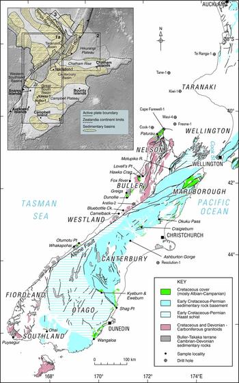
Simplified geological map of South Island, New Zealand showing Cretaceous rock outcrop and broad divisions of pre-Cretaceous basement with sample locations. Inset: southern Zealandia, showing Cretaceous–Cenozoic sedimentary basins studied: 1, present study area; 1a, area of main map; 2, 3, areas of previously published Cretaceous detrital zircon studies in northern and eastern New Zealand (Adams et al. Reference Adams, Mortimer, Campbell and Griffin2013a , Reference Adams, Mortimer, Campbell and Griffin b respectively).

Recent detrital zircon provenance studies of the basal Zealandia Megasequence (and its immediately underlying Early Cretaceous basement) in northern and eastern North Island, that is, from New Zealand basins closest to the present Pacific–Australian plate trench (Adams et al. Reference Adams, Mortimer, Campbell and Griffin2013a , Reference Adams, Mortimer, Campbell and Griffin b ), have identified clastic sand sources derived mainly from immediately underlying basement. However, some of the easternmost basins have surprisingly dominant inputs solely from westernmost parts of New Zealand, that is, from units well distant from the Pacific trench both now and during Cretaceous time. These provenance studies therefore hinted at a variable and evolving landscape across the Zealandia sector of Late Cretaceous Gondwana.
This present study now completes the regional survey of U–Pb detrital zircon age patterns of late Early – Late Cretaceous sandstones across Zealandia. Using the sampling and analytical methods described by Adams et al. (Reference Adams, Mortimer, Campbell and Griffin2013a , Reference Adams, Mortimer, Campbell and Griffin b ) we present here new data and interpretations of 1923 individual zircon age determinations from 37 samples of terrestrial and marginal marine sandstones collected across southern Zealandia (Fig. 1). Always bearing in mind the possibility of repeated zircon recycling, this allows us to determine in more detail the original Late Cretaceous sediment sources and to identify any similarities and differences (mixing and isolation) in space and time. These data are then used to describe the Cretaceous palaeogeography of the southern Gondwana margin before, during and after break-up.
2. Geological background
The New Zealand landmass includes a diverse range of Cretaceous rocks that includes granitoids, granulites and schists and older greywackes of the basement and younger less-consolidated and better-stratified clastic cover strata and intercalated volcanic rocks. The historical informal division into basement and cover has recently been formalized by Mortimer et al. (Reference Mortimer, Rattenbury, King, Bland, Barrell, Bache, Begg, Campbell, Cox, Crampton, Edbrooke, Forsyth, Johnston, Jongens, Lee, Leonard, Raine, Skinner, Timm, Townsend, Tulloch, Turnbull and Turnbull2014) who refer to the basement and cover rocks of New Zealand collectively as Austral Superprovince and Zealandia Megasequence, respectively. This new nomenclature is adopted here, but with some additional old names to allow back-reference to the related studies of Adams et al. (Reference Adams, Mortimer, Campbell and Griffin2013a , Reference Adams, Mortimer, Campbell and Griffin b ).
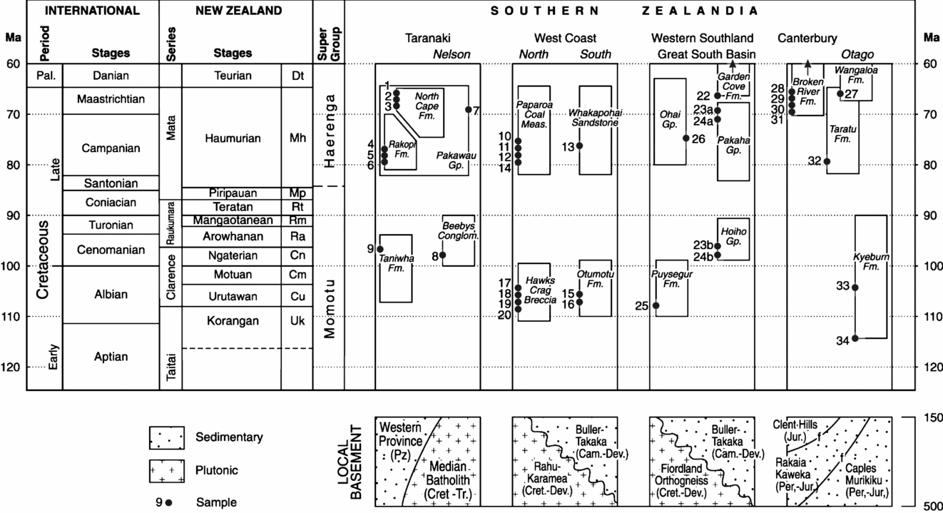
The Austral Superprovince is divided into Western and Eastern provinces that are, in turn, divided into several tectonostratigraphic terranes (Bishop, Bradshaw & Landis, Reference Bishop, Bradshaw, Landis and Howell1985), batholiths and igneous suites. The Western Province is essentially part of the early Palaeozoic foreland of eastern Gondwana; the Eastern Province is a collage of Permian–Cretaceous tectonostratigraphic terranes that are in part allochthonous and in part autochthonous, with respect to the continental foreland. Relevant parts are described below. The Zealandia Megasequence comprises first-order rift, transgressive and regressive sedimentary successions (King et al. Reference King, Naish, Browne, Field and Edbrooke1999; Uruski, Reference Uruski2010). The present study deals almost entirely with Late Cretaceous sandstones, the Momotu and Haerenga Supergroups, which form the lower parts of the Zealandia Megasequence (Fig. 2). The Momotu Supergroup comprises Albian–Coniacian syn-rift, non-marine and marine strata that make up the lowermost Zealandia Megasequence (e.g. Laird, Reference Laird and Plint1995). The base of the overlying transgressive Haerenga Supergroup records the commencement (c. 83 Ma) of widespread post-rift marine transgression (a sag phase associated with thermal subsidence), although terrestrial deposition continued within localized extensional, transform-related sub-basins in the west (Nathan et al. Reference Nathan, Anderson, Cook, Herzer, Hoskins, Raine and Smale1986). The Haerenga Supergroup comprises several laterally equivalent terrestrial, marginal marine and fully marine sedimentary successions (Nathan et al. Reference Nathan, Anderson, Cook, Herzer, Hoskins, Raine and Smale1986; King et al. Reference King, Naish, Browne, Field and Edbrooke1999).
Simplified stratigraphic columns of the Cretaceous–Cenozoic basins studied in this work, with sampled Cretaceous units. Ages of samples are approximate only. The probable nature of the local basement beneath each basin (where known) is also shown in cartoon form.

The Zealandia Megasequence is preserved in several major sedimentary basins across Zealandia (Fig. 1, inset), including the Taranaki, West Coast, Canterbury, Western Southland, Great South and Campbell basins which are studied in this paper. Most have extensive drillhole and seismic datasets and their stratigraphic successions and basin histories are well documented (Nathan et al. Reference Nathan, Anderson, Cook, Herzer, Hoskins, Raine and Smale1986; Field et al. Reference Field, Browne, Davy, Herzer, Hoskins, Raine, Sewell, Smale, Watters and Wilson1989; Beggs, Reference Beggs and Ballance1993; Turnbull et al. Reference Turnbull, Uruski, Anderson, Lindqvist, Scott, Morgans, Hoskins, Raine, Mildenhall, Pocknall, Beu, Maxwell, Smale, Watters and Field1993; King & Thrasher, Reference King and Thrasher1996; Cook, Sutherland & Zhu, Reference Cook, Sutherland and Zhu1999). In addition there is a modern 1: 250000 geological map coverage of the on-land parts of the basins (Bishop & Turnbull, Reference Bishop and Turnbull1996; Rattenbury, Cooper & Johnston, Reference Rattenbury, Cooper and Johnston1998; Forsyth, Reference Forsyth2001; Nathan et al. Reference Nathan, Rattenbury, Jongens and Suggate2002; Turnbull & Allibone, Reference Turnbull and Allibone2003; Rattenbury, Townsend & Johnston, Reference Rattenbury, Townsend and Johnston2006; Cox & Barrell, Reference Cox and Barrell2007; Forsyth, Barrell & Jongens, Reference Forsyth, Barrell and Jongens2008; Rattenbury, Jongens & Cox, Reference Rattenbury, Jongens and Cox2010; Turnbull, Allibone & Jongens, Reference Turnbull, Allibone and Jongens2010). We draw extensively on these authors to provide the basin summaries in the following sections. The stratigraphic successions in each of the above sedimentary basins are summarized in Figure 2, where the horizons of our detrital zircon sandstone samples are also shown.
Syntheses of New Zealand Cretaceous–Cenozoic basin geological histories have been provided by King et al. (Reference King, Naish, Browne, Field and Edbrooke1999) and Uruski (Reference Uruski2010, Reference Uruski, Gibson, Roure and Manatschal2015). In particular, these authors provide palaeogeographic maps of the Late Cretaceous – early Palaeogene intervals that document the Late Cretaceous – Oligocene marine transgression of the Zealandia Megasequence in all the basins. These maps provide a geographic-geological starting point from which the provenance information from detrital zircon patterns can be interpreted.
2.a. Taranaki Basin
The only productive petroleum basin in New Zealand is largely offshore from Taranaki, North Island (King & Thrasher Reference King and Thrasher1996). Western Province basement (Median Batholith and Takaka Terrane) has been penetrated in several wells (Mortimer, Tulloch & Ireland, Reference Mortimer, Tulloch and Ireland1997). Seismic study has identified a few occurrences of probable Momotu Supergroup syn-rift successions, but these have only been penetrated in the Te Ranga-1 well (Fig. 1) as Cenomanian shallow-marine and/or terrestrial sandstone, siltstone and coal (King & Thrasher, Reference King and Thrasher1996). However, the Haerenga Supergroup is widespread across the Taranaki Basin and comprises localized post-rift, terrestrial and marginal marine successions (Pakawau Group) overlain by more regionally continuous transgressive strata, for example terrestrial to marginal marine Kapuni Group (Palaeogene). The lower part of the Haerenga Supergroup is exposed onshore in the northwestern South Island, as represented by two formations of the Pakawau Group (Rakopi and North Cape) and the lowermost formation of the Kapuni Group (Farewell). The older Rakopi Formation comprises Campanian – early Maastrichtian fluvial-floodplain coal measure sandstones and siltstones (Browne et al. Reference Browne, Kennedy, Constable, Raine, Crouch and Sykes2010; Higgs et al. Reference Higgs, Arnot, Browne and Kennedy2010). The overlying Maastrichtian North Cape Formation records the first marine incursions as shallow-marine and marginal-marine environments but also conglomerate and sandstone (Fresne Conglomerate) and coal measure (Wainui Member) units. The exposed Farewell Formation comprises Paleocene (Danian–Thanetian) fluvial sandstones and conglomeratic sandstones, reflecting an upper coastal plain environment (Strogen et al. Reference Strogen, Baur, Bland, King and Strogen2011).
2.b. West Coast Basin
On-land Westland offers only a thin strip of outcrop (Fig. 1). The Western Province basement here is predominantly Early Ordovician metagreywackes (Buller Terrane) intruded by Devonian–Carboniferous granitoids mainly in the Karamea Batholith (but also Rahu Suite granitoids of the Paparoa Batholith). Prior to dextral Neogene transcurrent displacement (480 km) along the Alpine Fault, this region was adjacent to the SW margin of the Campbell Plateau. Similarly, pre-Neogene Taranaki and Western Southland basins would formerly have been adjacent.
The oldest sedimentary rocks of the Zealandia Megasequence are Albian, Momotu Supergroup terrestrial sandstones and conglomerates (Pororari Group, Hawks Crag Breccia and Otumotu Formation). These occur mainly in the north, that is, the Buller district of North Westland (Laird, Reference Laird and Plint1995), but scattered outliers occur as far south as Otumotu Point in South Westland. Predominant Pororari Group lithologies are red non-marine breccias, sandstones and siltstones. Petrofacies studies of some Pororari Group sandstones have identified separate greywacke and granitic sources (Nathan, Reference Nathan1978). Palynofloras and a local tuff horizon (Stitts Tuff) in Hawks Crag Breccia are of Albian age (Raine, Reference Raine1984; Nathan et al. Reference Nathan, Rattenbury, Jongens and Suggate2002). Our sample set also includes a possible Pororari Group red-bed succession in Bluebottle Creek (Fig. 1).
The Haerenga Supergroup is more widespread. The economically important Paparoa Coal Measures are in a NNE–SSW-aligned fault-bounded basin in North Westland (Paparoa Trough), c. 100 km long. This unit comprises entirely non-marine, fluvial and lacustrine, quartz-rich sandstones (all coarsening to the NW), mudstones and coals of mainly latest Cretaceous (Campanian–Maastrichtian) to early Paleocene age. Rare basalts 68–71 Ma in age are present within the lower formations (Sewell, Nathan & Adams, Reference Sewell, Nathan and Adams1988). Correlative units are encountered in the Aratika-2 drillhole to the east of the trough and possibly at Bluebottle Creek (Bell & Fraser, Reference Bell and Fraser1906). In South Westland, the Tauperikaka Coal Measures (Campanian–Maastrichtian) are overlain by marine Whakapohai Sandstone (Nathan et al. Reference Nathan, Anderson, Cook, Herzer, Hoskins, Raine and Smale1986).
2.c. Western Southland Basin
One of the few surface exposures of Momotu Supergroup in the Western Southland Basin is at Puysegur Point, Fiordland. Here, the Albian Puysegur Group comprises lacustrine and deltaic sandstones and siltstones (Bishop, Reference Bishop1986; Lindqvist, Reference Lindqvist, Mazengarb and Beggs1990). Local basement here includes high-grade Cretaceous metamorphic rocks intruded by Palaeozoic (Tuhua Intrusives) and Mesozoic (Median Batholith) granitoids. Haerenga Supergroup rocks also occur within the basin but are only exposed at Ohai in Northern Southland where Campanian–Maastrichtian coal, conglomerate, sandstone and coal (Ohai Group) rest on Eastern Province basement of the Brook Street Terrane (Turnbull & Allibone, Reference Turnbull and Allibone2003).
2.d. Great South Basin
The NE-striking Great South Basin is the largest sedimentary basin (100000 km2) on the Campbell Plateau and contains up to 7 km of sedimentary rocks. Its stratigraphic history has been defined by data from several oil exploration wells and several industry seismic surveys (Hunt International Petroleum, unpub. Petroleum Reports 716 and 730, 1977 and 1978; Beggs, Reference Beggs and Ballance1993; Cook, Sutherland & Zhu, Reference Cook, Sutherland and Zhu1999; Sahoo et al. Reference Sahoo, King, Bland, Strogen, Sykes and Bache2014). The local basement is Western Province metagreywacke (inferred correlative of Ordovician Greenland Group), intruded by granitoids of the Tuhua Intrusives. At its northern edge, the Great South Basin encroaches upon the Eastern Province basement. Syn-rift Momotu Supergroup successions are present as non-marine (but occasionally marine) Hoiho Group, which comprises slope-fan, deltaic and lacustrine conglomerates, sandstones, siltstones and occasional coal (Cook, Sutherland & Zhu, Reference Cook, Sutherland and Zhu1999). Haerenga Supergroup is represented by the Campanian–Paleocene Pakaha Group (which includes the prominent Kawau Sandstone). Within the Pakaha Group there is a progression from fluvial and marginal marine sandstone and siltstone to more thoroughly marine environments (with some local carbonate rocks and organic-rich mudstone). On the Campbell Plateau outside the major sedimentary basins, we have sampled two Haerenga Supergroup sandstones. Latest Cretaceous quartz-rich, non-marine sandstones and conglomerates (Garden Cove Formation) are locally exposed on Campbell Island (Oliver, Reference Oliver1950) and pass upwards, across the Cretaceous–Palaeogene boundary, into marine, earliest Paleocene siltstones (Hollis et al. Reference Hollis, Beu, Raine, Turnbull, Waghorn and Wilson1997). On Auckland Island, the Camp Cove Conglomerate is Oligocene in age while a spatially separate sandstone exposure, the Musgrave Formation, is Miocene in age (Ritchie & Turnbull, Reference Ritchie and Turnbull1985).
2.e. Canterbury Basin
The western margin of the Canterbury Basin rests unconformably upon Eastern Province greywacke of the Torlesse Composite Terrane and its metamorphosed equivalent (the Haast Schist). Syn-rift Momotu Supergroup rocks are mainly only present in restricted, fault-controlled exposures in the southern part of the basin at Kyeburn and Shag Point; these are Albian–Cenomanian terrestrial and fluvial conglomerates, sandstones, carbonaceous siltstones and rare coal. Silicic tuff horizons at both places have been dated at 112 Ma (Tulloch et al. Reference Tulloch, Ramezani, Mortimer, Mortensen, Van den Bogard, Maas, Ring and Wernicke2009). The basal overlying transgressive Haerenga Supergroup strata comprise dominantly fluvial, quartz-rich conglomerates and sandstones (Taratu Formation) that rest unconformably on Haast Schist. The Taratu Formation passes laterally and upwards into marginal marine Wangaloa Formation of Maastrichtian–Eocene age (Lindqvist & Douglas, Reference Lindqvist and Douglas1987; Pole, Reference Pole1992). In turn, this formation passes upwards into fully marine successions including greensands, siltstones and limestones. We note here that Momotu Supergroup (Waihere Bay Group) strata also occur on Pitt Island, Chatham Islands, c. 1000 km to the east (Fig. 1 inset) (Campbell et al. Reference Campbell, Andrews, Beu, Maxwell, Edwards, Laird, Hornibrook, de, Mildenhall, Watters, Buckeridge, Lee, Strong, Wilson and Hayward1993; Forsyth, Barrell & Jongens, Reference Forsyth, Barrell and Jongens2008).
The same succession is repeated in the northern part of the Canterbury Basin, where we have analysed samples from the Maastrichtian–Eocene Eyre Group (Haerenga Supergroup). This comprises the Broken River Formation, with fluvial quartz sands and occasional coals at the base, which passes upwards into shallow-marine Paleocene–Eocene glauconitic sandstones and mudstones (Forsyth, Barrell & Jongens, Reference Forsyth, Barrell and Jongens2008).
3. Methods
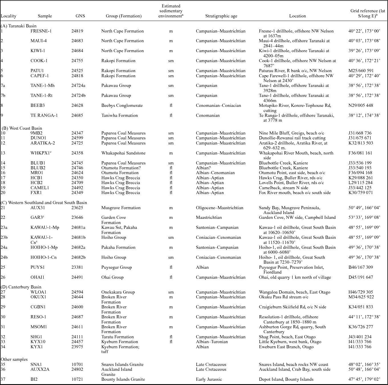
Coarse- to medium-sandstone (0.5 kg) samples were selected and reduced to centimetre-sized chips at the outcrop. Sample details are listed in Table 1. Locality numbers are noted throughout this text as italics in brackets, e.g. (1). A tungsten carbide swing-mill was used to acquire a single, broad 20–250 μm sized range to achieve as representative a sample as possible. The exceptions were extremely small (30–50 g) drill-core samples of washed cuttings in a <2 mm size range and consequently fewer zircons than desirable; in some cases <50 were obtained.
Cretaceous cover sandstones and related rocks, southern Zealandia: Sample localities.

a Estimated sedimentary environment: m: marine; sm: semi-marine, deltaic, estuarine; fl: terrestrial, fluvial, lacustrine
b Grid References refer to New Zealand 1:50 000 Map Series (NZMS260) version 231215
c Data previously published in Adams & Griffin (Reference Adams and Griffin2012).
Procedures for zircon mineral separation, mounting and polishing and inductively coupled plasma mass spectrometry (ICP-MS) U–Pb age determinations and their presentation are identical to those outlined in Jackson et al. (Reference Jackson, Pearson, Griffin and Belousova2004) and Adams et al. (Reference Adams, Mortimer, Campbell and Griffin2013a , Reference Adams, Mortimer, Campbell and Griffin b , Reference Adams, Mortimer, Campbell and Griffin2015). The ages reported here are from the outer parts of zircon grains, close to crystal faces and/or crystal terminations, avoiding older cores wherever possible. The great majority of zircon grains analysed fall within a 50–150 μm size range, and are mostly euhedral or show only modest abrasion. For samples with broadly unimodal age grouping, 20–40 zircon grains were analysed; for bimodal age grouping and more complex patterns, 40–60 and 60–80 were analysed, respectively. In some exceptionally small drill-core samples, these preferred criteria were unachievable. Also as an exception, zircons in the Fox River sandstone (20) were frequently metamict and seven discordant ages were rejected, resulting in a small sample set (29).
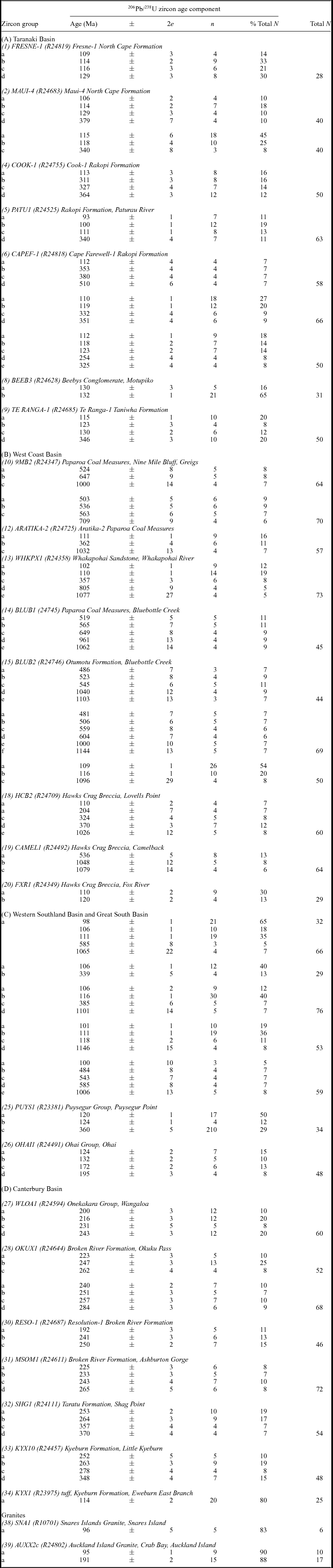
Data reduction and presentation were carried out using ISOPLOT 3:00 software (Ludwig, Reference Ludwig2003). Full analytical details and their interpretation (U–Pb, Th–Pb isotopic ratios, full U–Pb measured ages, accepted datasets and significant 206Pb/238U age components derived from them) are tabulated in Supplementary Data File 1 (available at http://journals.cambridge.org/geo). All accepted 206Pb/238U ages shown there have concordant 207Pb/235U–206Pb/238U ages and no or very low common-Pb corrections. The combined probability/histogram diagrams acquired with ISOPLOT are shown in Supplementary Data File 2 (organized by parent basins); these indicate age components that are regarded as significant and are summarized in Table 2. Also in Table 2 and Supplementary Data Files 1 and 2 we include new U–Pb zircon data from three Campbell Plateau granites, that is, from the Snares Islands, Auckland Island and Bounty Islands. These were dated to provide extra information on basement sources of zircon on the Campbell Plateau.
Detrital zircon U–Pb age components. Cretaceous cover successions, southern Zealandia. The letters a, b, c, etc. refer to the groups in online Supplementary Data File 1 (available at http://journals.cambridge.org/geo). e: errors are 95% confidence limits; n: number of grains in age group; N: total population of zircon grains analysed.

The New Zealand Geological Timescale (Cooper, Reference Cooper2004) is used here, with small subsequent changes of Raine et al. (Reference Raine, Beu, Boyes, Campbell, Cooper, Crampton, Crundwell, Hollis and Morgans2015).
4. Results
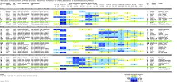
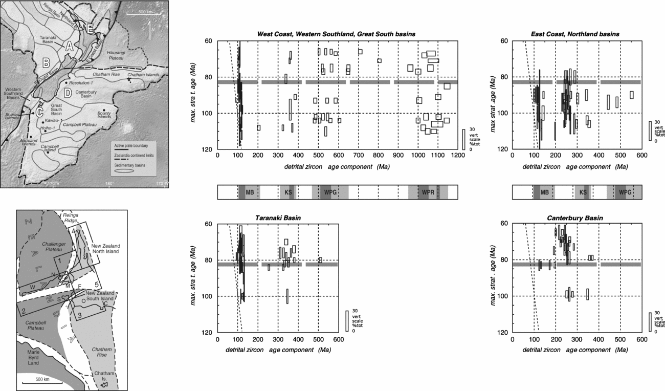
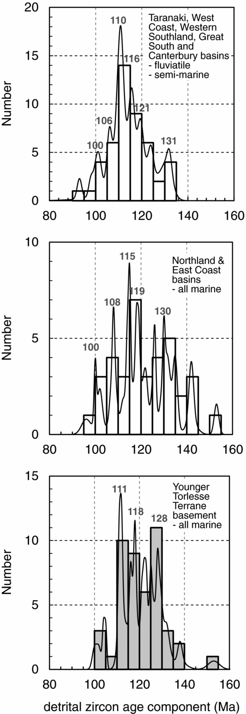
For ease of description, we group the 37 datasets by sedimentary basin: (A) Taranaki, (B) West Coast, (C) Western Southland Basin and Great South Basin and (D) Canterbury. In Figure 3, the individual zircon ages (N=1923) from 37 Cretaceous samples are grouped into selected geological periods. It is clear that the overwhelming majority of the detrital zircons (>99%) are substantially older than their sample depositional age, and there is very little contemporaneous Late Cretaceous zircon input into the sandstones. Early Cretaceous detrital zircon ages are the most common (>31% total), followed by Triassic–Permian (16%), Carboniferous–Devonian (13%) and Ordovician – Late Neoproterozoic (17%). In Figure 4, only the significant zircon age components derived from the probability density diagrams (Supplementary Data File 2, available at http://journals.cambridge.org/geo; summarized in Table 2) are displayed. Details of the significant age components in the Early Cretaceous interval in Figure 4 are expanded in Figure 5 to highlight their most popular values as indicated. Note also that Figures 4 and 5 include East Coast and Northland Basin data from the North Island (Adams et al. Reference Adams, Mortimer, Campbell and Griffin2013a , Reference Adams, Mortimer, Campbell and Griffin b ) so that these become complete New Zealand Late Cretaceous compilations.
Percentages of detrital zircons with selected geological age groupings, in Cretaceous cover successions across southern Zealandia. In each data block, the broad horizontal dashed line at 83 Ma approximately separates syn-rift Haerenga Supergroup from post-rift Momotu Supergroup successions.

Detrital zircon age components in sandstones from Cretaceous cover successions in Cretaceous-Cenozoic basin regions of this study as shown on Figure 1 (inset map), as follows: combined West Coast, Western, Southland and Great South basin (top left), Taranaki Basin (bottom left), Canterbury Basin (bottom right). To this is added data (top right) from Northland and East Coast basins (from Adams et al. Reference Adams, Mortimer, Campbell and Griffin2013a , Reference Adams, Mortimer, Campbell and Griffin b ). In each diagram, sample data are stacked vertically according to estimated maximum stratigraphic age. Detrital zircon component ages (horizontal axis) are taken from Table 2. The heights of data boxes represent the proportion (percentage) of the individual zircon age component in each sample (see scale bars at right).The broad horizontal dashed lines at 83 Ma separate syn-rift Haerenga Supergroup from post-rift Momotu Supergroup successions The dashed diagonal line defines the coeval oldest stratigraphic age limit and youngest detrital zircon age limit for any sample. A more detailed analysis of the rather compressed mid-Cretaceous sector (100-130 Ma) is further shown in Figure 5.

Probability density/histogram diagrams of significant detrital zircon age components (NB not individual ages) in mostly fluvial and semi-marine Late Cretaceous cover successions of the present study (top) and marine equivalents in Northland and East Coast basins from Adams et al. (Reference Adams, Mortimer, Campbell and Griffin2013a , Reference Adams, Mortimer, Campbell and Griffin b ) (middle), compared with analogous data from marine Early Cretaceous basement terranes (lower, highlighted with grey tint) in northern and eastern New Zealand (from Adams et al. Reference Adams and Griffin2013a , Reference Adams, Mortimer, Campbell and Griffin b ). Some common age peaks from the probability density curve are noted.

4.a. Variations between basins
4.a.1. Taranaki Basin
Most of the sandstones sampled from the Taranaki Basin have major Early Cretaceous and minor Carboniferous–Devonian zircon populations (2, 3, 5, 6, 7, 9) with only a few Ordovician – Late Neoproterozoic zircons. The Early Cretaceous and Carboniferous–Devonian detrital zircon populations match the temporal pulses of magmatism in the nearby Median Batholith (principally Early Cretaceous) and Karamea Batholith (principally Late Devonian – Early Carboniferous) (Muir et al. Reference Muir, Weaver, Bradshaw, Eby and Evans1995, Reference Muir, Ireland, Weaver and Bradshaw1996, Reference Muir, Ireland, Weaver, Bradshaw, Waight, Jongens and Eby1997; Mortimer et al. Reference Mortimer, Tulloch, Spark, Walker, Ladley, Allibone and Kimbrough1999). At the single-locality level however, the principal zircon groups show considerable variation: (1) within the probable Western Province basement region, the Cook-1 (4) and Cape Farewell (6) datasets do not have the major Cretaceous zircon groups (which might be expected from the nearby Rahu Suite and Median Batholith granitoids, respectively) but instead there are large (>90%) Palaeozoic and/or Precambrian populations that represent zircons recycled from Palaeozoic basement rocks; and (2) the opposite extreme is seen in the Motupiko (8) and Fresne-1 (1) datasets where Cretaceous zircons make up >70% of the sample. At Motupiko (8), Beeby's Conglomerate is locally unconformable on Brook Street Terrane rocks but has no recycled Permian or Triassic zircons from that terrane (Adams, Campbell & Griffin, Reference Adams, Campbell and Griffin2007). Instead, it has zircons derived exclusively from Early Cretaceous sources (of which >80% are Berriasian–Barremian), probably from the Median Batholith granitoids immediately to the west. At Fresne-1 the minor groups of Jurassic and Permian zircons are unusual in this basin, with the former having a probable source within the minor Jurassic plutons of the Median Batholith, while a source for the latter is uncertain, possibly from minor granitoids within the Brook Street Terrane.
4.a.2. West Coast, Western Southland and Great South basins
Samples from the West Coast, Western Southland and Great South basins commonly have abundant Early Cretaceous zircons (16–20, 22–25). Unlike the Taranaki Basin datasets, there are few or no Devonian–Carboniferous zircons; instead there are substantial late Mesoproterozoic – Ordovician zircon populations, especially at the northern localities (10–16, 19). The Precambrian – early Palaeozoic zircon groups are characteristic of the Buller and Takaka terranes of the Western Province (Adams et al. Reference Adams, Mortimer, Campbell and Griffin2015), but the Early Cretaceous and Devonian–Carboniferous zircons suggest Median, Paparoa and/or Hohonu Batholith plutonic sources. At three localities (17, 24a, 25) late Early Cretaceous zircons very much dominate (often >60%), presumably reflecting prominent local granitoid sources, and the Palaeozoic–Precambrian zircon proportions are accordingly much reduced. The Ohai locality (26) is an exception here with a large proportion (60%) of Jurassic and Triassic zircons, which reflects recycling from the local Murihiku Terrane (here Triassic and Jurassic). In addition, its significant Early Cretaceous zircon population (38%) was presumably derived from the Median Batholith immediately to the west. The dataset from the Hawks Crag Breccia (18) shows an interesting variation on the above patterns with the inclusion of an unusual and significant (12%) group of Jurassic–Triassic zircons whose provenance is uncertain. The Triassic zircons might be recycled from volcaniclastic sandstones such as those in the nearby Topfer Formation (Triassic), now only seen very locally in outcrop, but perhaps formerly overlying basement more extensively in this region (Nathan et al. Reference Nathan, Rattenbury, Jongens and Suggate2002).
4.a.3. Canterbury Basin
Sandstones from the Canterbury Basin have dominantly Triassic–Permian zircons but also significant minor contributions of Carboniferous (27, 32, 33), early Palaeozoic and late Neoproterozoic zircons (28–33) and, in a few cases (27, 30, 31), minor groups of Early Jurassic and Early Cretaceous zircons. The major Permian–Triassic detrital zircon proportions are characteristic of Eastern Province greywacke-schist terranes in general and, with the addition of minor early Precambrian–Palaeozoic zircons, the local Rakaia Terrane basement in particular (Adams, Campbell & Griffin, Reference Adams, Campbell and Griffin2007) from which they are therefore recycled. A latest Cretaceous sandstone (27) at Wangaloa is unconformable here upon Caples Terrane basement, but the youngest zircons in this dataset, aged <200 Ma, suggest a maximum earliest Jurassic depositional age, an age range at the extreme youngest age limit for the Caples Terrane in general (Adams, Campbell & Griffin, Reference Adams, Campbell and Griffin2009). Jurassic and early Early Cretaceous significant age components are rare but an interesting example occurs in the dataset (29) from Resolution-1 drillhole (Milne, Simpson & Threadgold, Reference Milne, Simpson and Threadgold1975), which has an Early Jurassic 192±1 Ma (Table 2) component. This is similar to the Bounty Islands Granite (37) to the east, here dated at 191±2 Ma. In these examples additional zircon contributions, perhaps recycled from the Permian, Triassic or Jurassic formations of the Murihiku and Brook Street terranes, cannot be excluded. A rare tuff member (34) in Kyeburn Formation in East Otago is here dated at 114±2 Ma, indicating that the formation as sampled at locality (33) extends to earliest Albian time.
4.a.4. Variations across the syn- to post-rift transition
Across a time interval at c. 83 Ma, from syn-rift (Momotu Supergroup) to post-rift (Haerenga Supergroup) sedimentary cover successions, the zircon age populations within individual regions show few dramatic changes, either in absolute values or their proportions (Figs 3, 4). Two exceptions to this pattern are: (1) an increase in late Palaeozoic zircons in the Haerenga Supergroup of the Taranaki Basin, suggesting direct derivation from newly created upland regions in the Devonian–Carboniferous, Karamea Batholith; and (2) outside the present study region, there is a decrease in early Palaeozoic and Precambrian detrital zircons in the Haerenga Supergroup in the East Coast and Northland basins, suggesting that the zircon sources in Western Province basement, clearly available prior to c. 83 Ma, had become buried by marine transgression commencing at that time.
4.b. Cretaceous detrital zircons
There are important similarities in the distribution of Early Cretaceous zircon populations across the New Zealand basins. In Figure 5, a compilation of all the significant age components (not individual ages) from all the datasets indicates four age groupings – c. 100 Ma, 108–110 Ma, 115–116 Ma and 130–131 Ma – that are common in all the basins (except the Canterbury Basin). In the Taranaki Basin sandstones the Early Cretaceous aged components are more commonly 110–130 Ma (2, 3, 6–9) while the West Coast – Western Southland and Great South Basin samples (13, 17, 18) commonly have a slightly younger range of 100–115 Ma. In general, these groups are similar to the principal Cretaceous magmatic pulses within the Median Batholith (Muir et al. Reference Muir, Weaver, Bradshaw, Eby and Evans1995, Reference Muir, Ireland, Weaver and Bradshaw1996, Reference Muir, Ireland, Weaver, Bradshaw, Waight, Jongens and Eby1997). However, in the Great South Basin datasets (22–24), the youngest age components (c. 100–106 Ma) are younger than any of these. Surprisingly, in these Great South Basin localities there are few (<2%) zircons dated 90–100 Ma that could have been derived from Campbell Plateau granites such as those at Snares Islands (35) and Auckland Island (37), here dated at 96±5 and 95±1 Ma, respectively (Table 2). However, zircons from the latter do dominate the Miocene Musgrave Formation sandstone on Auckland Island (21).
4.c. Pre-Cretaceous detrital zircons
Pre-Cretaceous zircons are common in all the datasets except (8), and their main age groups in terms of basement zircon sources to Cretaceous cover successions relevant to individual basins have been outlined above.
Comparing the total Late Cretaceous sandstone zircon datasets from the Eastern and Western Province it is readily apparent that Permian–Triassic zircons are far more abundant, in terms of both individual zircon proportions (Fig. 3) and significant age components (Fig. 4), than their Western Province counterparts. This feature clearly reflects the fact that basement rocks in the Eastern Province tectono-stratigraphic terranes developed in an active accretionary wedge whose first-cycle sediment inputs were dominantly from Carboniferous–Jurassic (principally Permian–Triassic) magmatic arcs beyond the Western Province, that is, they are allochthonous, and from a NE Australian sector of the Gondwana continental margin (Adams, Campbell & Griffin, Reference Adams, Campbell and Griffin2007). The provenance of the minor Palaeozoic and Precambrian zircons in these Eastern Province basement rocks is probably the continental hinterland to these magmatic arcs.
The Cretaceous cover successions in the Western Province provide a different picture. The pre-Cretaceous zircons are commonly >300 Ma old and form three principal age groups: (1) Late Devonian – Carboniferous with significant age components, c. 325–355 and 365–380 Ma, particularly in offshore Taranaki and, to a lesser extent, c. 360–385 Ma in Westland, Fiordland and on the Campbell Plateau; (2) late Neoproterozoic – Early Ordovician zircons with significant zircon age components in the range 470–700 Ma; and (3) rather scattered Precambrian individual zircon ages, in a broad range >700 Ma and as old as 3235 Ma, but with significant late Mesoproterozoic components aged c. 1000–1200 Ma (Fig. 3, Table 2). These three zircon age groups are readily matched with the age patterns from the Palaeozoic basement of the Western Province in Zealandia (Adams et al. Reference Adams, Mortimer, Campbell and Griffin2015), or potentially from similar rocks present in formerly adjacent parts of Gondwana, that is, SE Australia and Antarctica. The nature of the mid-Cretaceous Gondwana break-up that formed Zealandia, and distinctive features of Zealandia's Palaeozoic basement, suggest that zircon recycling was solely from the Zealandia basement as discussed in more detail in the following section.
5. Discussion
When combined with the results of Adams et al. (Reference Adams, Mortimer, Campbell and Griffin2013a , Reference Adams, Mortimer, Campbell and Griffin b ), the results of the present study provide a complete regional dataset of detrital zircon ages from Early and Late Cretaceous sandstones that spans the tectonic transition from convergence to extension in the Zealandia sector of Gondwana (King et al. Reference King, Naish, Browne, Field and Edbrooke1999). With detrital zircons as their proxy, this allows the identification of the major sediment sources, their extent and duration, and the disposition of the regional river-drainage systems across southern Zealandia.
5.a. Isolation of Zealandia from Gondwana
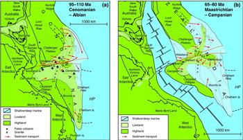
The Zealandia continent separated from Gondwana (Australia and Antarctica) as new seafloor was progressively created in the SW Pacific Ocean and Tasman Sea. From the seafloor palaeomagnetic record, southern Zealandia was substantially isolated from Gondwana by c.83 Ma (Fig. 6; see also Sutherland et al. Reference Sutherland, Stagpoole, Uruski, Kennedy, Bassett, Henrys, Scherwath, Kopp, Field, Toulmin, Barker, Bannister, Davey, Stern and Flueh2009, figure 14) but the northern sector of Zealandia remained connected until Palaeogene time. Along these spreading centres there would necessarily have been a preceding phase of uplift and consequent rift-formation, as confirmed by the strong evidence for Albian–Santonian (c.113–83 Ma) syn-rift tectonic environments and extensional sedimentary basins (Laird, Reference Laird and Plint1995; Norvick et al. Reference Norvick, Smith and Power2001, Reference Norvick, Langford, Hashimoto, Rollet, Higgins and Morse2008; Uruski, Reference Uruski2010; Strogen et al. Reference Strogen, Baur, Bland, King and Strogen2011). For these reasons, any ancestral Cretaceous river systems draining from interior Eastern Gondwana across the southern Zealandia continental margin would have been severed at this time, and all the late Early – Late Cretaceous sandstones studied here would therefore have had their sediment sources entirely within Zealandia (Fig. 6). Clearly however, most of the older (e.g. early Palaeozoic) inherited zircons in these rocks could potentially have come from Australian/Antarctic sources, to be recycled from their Zealandia host rocks later (e.g. the early Palaeozoic Greenland Group). However, the early Palaeozoic sandstones in the New Zealand Western Province often have detrital zircon components in the range 600–700 Ma, absent from their Australian and East Antarctic counterparts, which suggests that their original sources are probably within (present-day) Zealandia (Adams et al. Reference Adams, Mortimer, Campbell and Griffin2015). It is notable that such 600–700 Ma components, recycled from local basement, are seen in the Late Cretaceous, mainly fluvial, cover successions at western and southern localities (10, 11, 14, 16).
Cretaceous palaeogeography and regional pre-Late Cretaceous basement at: (a) syn-rift, Albian–Cenomanian (c. 100–110 Ma) termination of the active Gondwanaland margin in southern Zealandia; and (b) Campanian–Maastrichtian (c. 65–80 Ma) after final continental break-up to form Zealandia. Zealandia continental block reconstructions are after Gaina et al. (Reference Gaina, Müller, Royer, Stock, Hardebeck and Symonds1998) and Sutherland (Reference Sutherland1999). The broad dashed orange lines, approximating the present-day Alpine Fault region, denote a zone between northern and southern Zealandia across which considerable adjustment has been made to the original rigid-block configuration to allow proper alignment of basement terranes in Cretaceous time. Basement is shown as: Eastern Province (dashed), Median Batholith and possible Cordillera Zealandia (++), Western Province (medium stipple), possible Precambrian basement (coarse stipple). ‘Highland’ terrain invokes mountains, volcanic plateaux and deserts whereas ‘lowland’ terrain invokes fluvial, deltaic and semi-marine. Note that areas of the Gondwana margin that were potentially upland and therefore available for erosion are particularly uncertain on the Lord Howe Rise, Challenger Plateau, the Ross Sea region of Antarctica, Fiordland and northern North Island, New Zealand. Red arrows show suggested directions of sediment transport from source to basin. The curved red arrows with circle endings denote a ‘privileged’ transport corridor, that is, without intervening sediment inputs (Adams et al. Reference Adams, Mortimer, Campbell and Griffin2013a , Reference Adams, Mortimer, Campbell and Griffin b ).

5.b. Cretaceous zircon sources within Zealandia
As noted above, the great majority of detrital zircon ages are substantially older than the depositional ages of their parent Late Cretaceous sandstones. This is in contrast to the situation in the Early Cretaceous Torlesse, Waipapa and Caples terranes of the Eastern Province, where the sandstones have youngest significant zircon age components coincident with their depositional age (Cawood et al. Reference Cawood, Nemchin, Leverenz, Saeed and Ballance1999; Pickard, Adams & Barley, Reference Pickard, Adams and Barley2000; Adams, Campbell & Griffin Reference Adams, Campbell and Griffin2007; Adams et al. Reference Adams, Mortimer, Campbell and Griffin2013a , Reference Adams, Mortimer, Campbell and Griffin b ). The explanation for this is twofold. Sandstones of the Momotu and Haerenga Supergroup are not first-cycle sandstones, and therefore have very high proportions of recycled zircons. In contrast, the greywackes of the Torlesse Terrane for example combine products of erosion and redeposition of Palaeozoic greywackes, as well as contemporary contributions from Permian–Triassic magmatic rocks. Momotu and Haeranga sandstones have very few Late Cretaceous zircon grains and this is compatible with the paucity of known penecontemporaneous magmatism (compared with voluminous pre-100 Ma magmatism) in New Zealand (see also Tulloch et al. Reference Tulloch, Ramezani, Mortimer, Mortensen, Van den Bogard, Maas, Ring and Wernicke2009).
In our dataset, we can clearly identify true juvenile zircon input only in the tuff sample (34) dated at 114±2 Ma from the Kyeburn Formation of the Canterbury Basin, and in the Taranaki Basin sandstone at Paturau River (5) which has a 98±1 Ma Late Cretaceous component and, uniquely, individual zircon ages of 81±2 and 84±2 Ma, close to its Campanian–Maastrichtian depositional age (see Table 2). It is possible that the zircons of the Whakapohai and Hoiho sandstones (13, 24a, 24b) with their significant 100–102 Ma age components may also have been derived from syn-rift magmatism (Tulloch et al. Reference Tulloch, Ramezani, Mortimer, Mortensen, Van den Bogard, Maas, Ring and Wernicke2009), but the transition from youngest subduction-related to oldest rift-related igneous and sedimentary rocks can only be approximately placed in the 110–100 Ma interval.
5.c. Late Cretaceous sediment paths in Zealandia
In the southern Zealandia region, the Late Cretaceous sandstone detrital zircon patterns clearly reflect recycling of (1) metasedimentary rock sources in the west, from early Palaeozoic basement of the Western Province and in the east, from Permian–Cretaceous basement of the Eastern Province; and (2) primary granitoid sources from the Cretaceous (mainly) and Jurassic plutons of the Median Batholith (Fig. 4).
5.c.1. Taranaki, East Coast and Northland basins
In the eastern regions, that is, the Canterbury Basin, zircon inputs from the Median Batholith into the mostly non-marine to marginal marine successions are entirely absent; local Torlesse Composite Terrane was the main sediment source (Fig. 4). This is in contrast to the entirely marine East Coast and Northland basins, where Momotu Supergroup successions (here Albian–Turonian, 110–90 Ma) have detrital zircons derived from the Median Batholith as well as others recycled from local Eastern Province basement (Waipapa, Kaweka and Pahau terranes). The zircon patterns in the Momotu sandstones are similar to those in the local basement rocks, here Pahau (Barremian–Albian) and Waipapa (Late Triassic – Early Cretaceous) terranes (Fig. 4). However, in the late Late Cretaceous (Santonian–Campanian) Haerenga Supergroup successions, there is a gradual diminution of Aptian–Albian zircon components derived from the Median Batholith (Adams et al. Reference Adams, Mortimer, Campbell and Griffin2013a , Reference Adams, Mortimer, Campbell and Griffin b ). Mortimer et al. (Reference Mortimer, Gans, Palin, Meffre, Herzer and Skinner2010) note the dominance of <100 Ma zircons in a sandstone from the Reinga Basin.
Occupying a position interior to the entirely marine East Coast and Northland basins, the marine to marginal marine Cretaceous cover successions of the Taranaki Basin also have major late Early Cretaceous zircon inputs from the Median Batholith, but also minor Devonian–Carboniferous contributions from the Karamea Batholith further to the west (Fig. 4). Unlike the East Coast Basin and Northland Basin examples above, this pattern continues through the transition from the Momotu to the Haeranga Supergroup. In addition, there are almost no Permian–Triassic zircon contributions from the Eastern Province (Waipapa and Pahau) terranes.
To summarize, the detrital zircon patterns of the Taranaki, East Coast and Northland basin demonstrate that during the syn-rift phase of Gondwana break-up (c. 110–83 Ma), the Median Batholith was a major upland sediment source contributing zircons to all the fluvial, marginal marine and marine depositional basins to the east. In the Taranaki Basin this included a small proportion of Devonian–Carboniferous zircons derived from the Karamea Batholith to the west but, in the East Coast and Northland basins, these are much diminished and are replaced by major zircon contributions from the local basement there (Pahau and Waipapa terranes). For the Taranaki, East Coast and Northland basins, the regional drainage gradients therefore appear to be from (present-day) west to east. In the latest Cretaceous post-rift stage (<83 Ma), these patterns are only modified with the loss of Median Batholith zircon inputs into the East Coast and Northland basins, suggesting a degree of separation between them, that is, a developing depositional basin acting as a barrier.
5.c.2. Canterbury Basin
In the Canterbury Basin, the absence of the Early Cretaceous zircons from the Median Batholith, so characteristic of the Taranaki, East Coast and Northland basin datasets (above), is striking. This indicates that the local basement, mainly within the Torlesse Composite Terrane, was a substantial eroding upland area supplying the Canterbury Basin with a regional drainage gradient from west to east, and the absence of zircons from the Median Batholith suggests that it was not part of this hinterland.
5.c.3. West Coast and Western Southland
In contrast to the Eastern Province examples discussed above, the basin sandstones of the West Coast and Western Southland clearly have variable and localized sediment sources (Figs 3, 4). Early Cretaceous (130–110 Ma) zircon populations often dominate and are almost certainly derived from the Median Batholith to the east and/or the Rahu Suite granitoids to the west, However, the zircon populations are highly variable (0–72% total, Fig. 3) and are sometimes overwhelmed by older components (late Neoproterozoic – Ordovician, c. 700–450 Ma; late Mesoproterozoic, c. 1000–1200 Ma; Fig. 3), that are more characteristic of the Western Province metasedimentary basement (Adams et al. Reference Adams, Mortimer, Campbell and Griffin2015). Evidence for local and variable sources is particularly striking in seven relatively closely spaced West Coast Basin localities (Fig. 3). At Nine Mile Bluff (10), Dunollie (11), Bluebottle Creek (15) and Camelback (19), the zircon sources seem to have been entirely within the local Greenland Group (Early Ordovician) basement. It is surprising that there is no additional significant contribution from Devonian–Carboniferous Karamea Suite granitoids that should have been exposed in the early Palaeozoic basement nearby at that time. However, at the Cook-1 drillhole (4), Motupiko (8) and Hawks Crag (17, 18) localities, Devonian–Carboniferous and/or Cretaceous zircons do predominate. These 130–100 Ma zircons have nearby sources in the Median Batholith (8) and the plutons/core complexes of the Rahu Suite (17, 18) (Fig. 6a; Tulloch & Kimbrough, Reference Tulloch and Kimbrough1989). The Devonian–Carboniferous zircons in (4) would have had their sources in the Karamea Batholith to the east.
5.c.4. Great South Basin and Campbell Plateau
In the Great South Basin and on the adjacent Campbell Plateau, there is a similar situation; any extension of the Median Batholith is uncertain however, as some Cretaceous zircon component ages (c. 100–106 Ma (22–24)) are younger than those in West Coast Basin sandstones. Again, there are few Devonian–Carboniferous zircons and the late Neoproterozoic – early Palaeozoic and late Mesoproterozoic age groups are often more important (22, 24b). In general, the variability of the zircon sources suggests the presence of very local Late Cretaceous watersheds and short sediment transport distances within the Western Province, rather than an interchange of separate river-born sediments from separate distant sources.
5.d. The nature of mid-Cretaceous sediment source regions
The Median Batholith was a major sediment source during mid-Cretaceous time (c. 110–83 Ma), and would therefore have occupied an extensive granitoid upland area at the heart of Zealandia. This would have constituted, at the very least, a major plateau perhaps with associated volcanic edifices upon it (a rather speculative proposition, as good evidence is lacking). A more dramatic scenario by Tulloch et al. (Reference Tulloch, Beggs, Kula, Spell and Mortimer2006) proposed the existence of an Andean-style, Cretaceous ‘Cordillera Zealandia’ mountain range above the Median Batholith. This was postulated on the basis of the isostatic compensation required above a 40 km thick granulite crust.
A major drainage divide must therefore have existed within on-land Zealandia, certainly prior to continental break-up (Fig. 6a) and possibly after that (Fig. 6b). Long river systems would have extended out from a central upland region towards the eastern depositional basins (Taranaki, East Coast Northland), while those draining into western depositional basins (West Coast, Western Southland, Great South) and fluvial successions on the Campbell Plateau would have been shorter and more localized.
Adams et al. (Reference Adams, Mortimer, Campbell and Griffin2013a , Reference Adams, Mortimer, Campbell and Griffin b ) noted the occurrence of distinctively high proportions of Western Province detrital zircons and corresponding diminution of Cretaceous Median Batholith zircons in late Early and Late Cretaceous (Waioeka Terrane and Houhora Complex, respectively) sandstones that are now at the easternmost margin of the Eastern Province. It was concluded that transporting such sediments would require: (1) a major antecedent river cutting across the Median Batholith upland, acting as a significant sediment transport corridor (Fig. 6a); and/or (2) possible assistance by longshore coastal drift at the Gondwana continental margin; or (3) postulating a local sector of the Gondwana margin with Western Province rocks exposed there during middle Late Cretaceous time.
Bialas et al. (Reference Bialas, Buck, Studinger and Fitzgerald2007) postulated rift-edge uplift between Cretaceous East and West Antarctica. Speculatively, such rift-edge uplifts may have been generated around the periphery of what was to become Zealandia (c. 120–110 Ma). It is possible that at the syn-rift stage such uplifted Zealandia flanks could have briefly supplied sediment to local Cretaceous basins, for example exhumed early Palaeozoic basement in Westland as a source for the West Coast Basin sediments, and possibly early Palaeozoic/Precambrian basement for parts of the Great South Basin (Adams & Griffin, Reference Adams and Griffin2012). At the close of the syn-rift stage (c. 83 Ma), these uplifted rift edges, now eroded, would have gradually subsided to allow the major post-rift, post-Santonian marine transgression across southern Zealandia. We note, however, that not all of the Zealandia part of Gondwana would have been land during the interval 105–85 Ma. For example, Norvick et al. (Reference Norvick, Smith and Power2001, Reference Norvick, Langford, Hashimoto, Rollet, Higgins and Morse2008) and Bache et al. (Reference Bache, Mortimer, Sutherland, Collot, Rouillard, Stagpoole and Nicol2014) have all suggested that several pre-85 Ma basins on the Lord Howe Rise contain well-stratified (possibly marine) rocks, capped by unconformities. Substantial marine inundation of Zealandia may have begun prior to c. 85 Ma, bolstering the case that, from this time, detrital zircons of any age could not have been sourced from Australia or Antarctica.
5.e. Cryptic Cretaceous zircon sources
The most common Cretaceous-age components in the detrital zircon populations (Fig. 5) are c. 110, 120 and 130 Ma in all areas (except Canterbury where representation is limited; Fig. 4). However, the samples from the Great South Basin and Campbell Plateau (22–24) have younger components (c. 110–100 Ma; Fig. 5) more commonly than their counterparts to the north. This may suggest that the Campbell Plateau, unlike the Nelson and Fiordland granitoid complexes, is underlain by substantial areas of younger 105–95 Ma granites, as represented on Auckland and Snares Islands (35, 36). These could be part of the extensive area of anorogenic (A-type) granite magmatism, unrelated to the Median Batholith that is widespread in Marie Byrd Land and more associated with Cretaceous rifting of West Antarctica from southern Zealandia (Weaver et al. Reference Weaver, Adams, Pankhurst and Gibson1992; Richard et al. Reference Richard, Smith, Kimbrough, Fitzgerald, Luyendyk and McWilliams1994; Adams, Seward & Weaver, Reference Adams, Seward and Weaver1995; Bradshaw et al. Reference Bradshaw, Pankhurst, Weaver, Storey, Muir, Ireland and Ricci1997; Pankhurst et al. Reference Pankhurst, Weaver, Bradshaw, Storey and Ireland1998). A similar preponderance of younger ages is also seen in the Northland Basin, where late Early Cretaceous sedimentary rocks in the Houhora Complex and Late Cretaceous horizons within the Northland Allochthon (Adams et al. Reference Adams, Mortimer, Campbell and Griffin2013a ) have common zircon age components <110 Ma, probably derived from rift-related, anorogenic A-type magmatic sources within northern Zealandia and unrelated to the Median Batholith (Tulloch et al. Reference Tulloch, Ramezani, Mortimer, Mortensen, Van den Bogard, Maas, Ring and Wernicke2009).
5.f. Cryptic Precambrian zircon sources
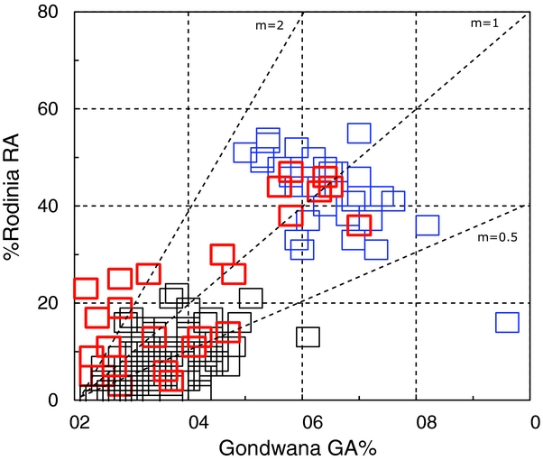
Adams & Griffin (Reference Adams and Griffin2012) and Adams et al. (Reference Adams, Mortimer, Campbell and Griffin2015) speculated that late Mesoproterozoic complexes (1200–1000 Ma) are present in southwestern Zealandia. This suggestion was based on the presence of unusually high proportions of Rodinian-age (RA, 1600–700 Ma) compared with Gondwanan-age (GA, 700–442 Ma) detrital zircons in Late Cretaceous sandstones. In Figure 7, the original data (13, 22, 23b) are here combined with 22 new data from the present study (Fig. 7) in which their RA/GA ratios can be compared with those from all published Eastern and Western Province basement sources. Of these 25 Cretaceous cover succession datasets, five have RA/GA ratios (m) >2 and support the original proposition that such ratios could not have been acquired by derivation of primary or recycled zircons from any known basement sources (or mixture of sources) cropping out anywhere within Zealandia. This is another reason that speculative uplift at Cretaceous rift flanks of southern Zealandia during the Albian–Santonian interval could have provided sediment sources from an exhumed (but now reburied) Precambrian (Rodinian) basement.
Percentages of detrital zircons in sandstones from Cretaceous cover successions across southern Zealandia (red) originating in the Rodinia (RA) and Gondwana (GA) supercontinents, compared with data from Western Province (blue) and Eastern Province (black) basement. Data points represent individual sandstone samples; combined zircon population totals of <100% reflect samples with significant additional populations from post-Gondwana sources (most evident in the Eastern Province samples). Some representative RA/GA ratios (m) are shown.

It is acknowledged that Gibson & Ireland (Reference Gibson and Ireland1995) argued for the absence of a Precambrian basement in the Fiordland sector of the Western Province based on studies of mostly Cretaceous granulite and orthogneiss. However, inherited Precambrian ages have subsequently been found in these rocks (Scott et al. Reference Scott, Palin, Cooper and King2009). In the Nelson-Buller sector of the Western Province, the Cretaceous granitoids also contain inherited Precambrian zircons (Muir et al. Reference Muir, Ireland, Weaver and Bradshaw1994). More recently, Precambrian detrital zircons have been recovered from Early Ordovician graptolitic slate and quartzite formations in southwest Fiordland. They are abundant in the latter, reaching 90% of total (Adams et al. Reference Adams, Mortimer, Campbell and Griffin2015).
6. Conclusions
Detrital zircon populations in 37 late Early – Late Cretaceous sandstones from sedimentary basins in southern Zealandia reveal provenances relevant to palaeogeography during Gondwana supercontinent break-up. Most samples have local detrital zircon provenances in the immediately adjacent basement, that is, from early Palaeozoic (Western Province) and Jurassic–Permian (Eastern Province) metasedimentary basement and/or the Median Batholith. Wholesale mixing of zircons from both provinces is not seen. The zircon sources for the Taranaki, Canterbury, East Coast and Northland basins can be reconciled with a general west–east regional drainage gradient, with greater proportions of Median Batholith zircons in the Taranaki Basin sandstones and Eastern Province metasedimentary basement zircons in the Canterbury Basin sandstones. Samples from the West Coast Basin represent extreme variations in zircon populations from exclusively Western province zircon sources, ranging from exclusively plutonic (Median Batholith, Karamea and Rahu Suite granites) to exclusively metasedimentary basement (Buller and Takaka terrane) sources and, as such, reflect localized sediment supply from small fluvial catchments and with no regionally consistent drainage gradient. In the sandstones of the Great South Basin and Campbell Plateau, zircons of age 100–110 Ma are more common than in the other basin datasets, and possibly originated from regional, intraplate anorogenic granites rather than the slightly older Median Batholith.
The Median Batholith was a major source of sediment and zircons for both syn-rift and post-rift sandstones (principal components are mostly c. 110, 116, 121 and 131 Ma) in most basins, and must therefore have constituted a major upland source area through late Early and Late Cretaceous time. Its influence as a source region diminishes to the north (Northland Basin) in the post-rift (Santonian–Campanian) phase, to be replaced by slightly younger (Albian–Cenomanian) zircon sources. Jurassic zircon components that could originate from the Median Batholith are extremely rare. In southern Zealandia, some mid-Cretaceous sediments may have originated from Precambrian basement exhumed locally at the Zealandia margin during the syn-rift stage.
This study completes three regional detrital zircon surveys of the provenance of Cretaceous sandstones across the New Zealand region (see also Adams et al. Reference Adams, Mortimer, Campbell and Griffin2013a , Reference Adams, Mortimer, Campbell and Griffin b ). Together they provide a comprehensive provenance perspective and coherent geological interpretation of the separation and ultimate isolation of Zealandia from Gondwana.
Acknowledgements
The authors thank GNS Science colleagues Simon Nathan, Mark Rattenbury, John Begg, Ian Turnbull and the late Malcolm Laird for sharing their extensive knowledge of regional Cretaceous geology. Ministry of Business Innovation and Employment, Wellington kindly provided access to core samples from oil-exploration drillholes. The research was supported through New Zealand Government core-funding to GNS Science. Peter King and colleagues in the GNS Basin Studies Group provided valuable advice regarding best selection of drillhole samples in the Taranaki, West Coast and Canterbury basins and provided financial support for the zircon analyses. Norman Pearson and Will Powell at GEMOC, Macquarie University, Sydney provided important technical assistance throughout the programme. This is contribution 529 from the Australian Research Council Centre of Excellence for Core to Crust Fluid Systems (http://www.ccfs.mq.edu.au) and 972 in the GEMOC Key Centre (http://www.gemoc.mq.edu.au). The analytical data were obtained using instrumentation funded by DEST Systemic Infrastructure Grants, ARC LIEF, NCRIS, industry partners and Macquarie University. Philip Carthew at GNS Science is thanked for careful preparation of the diagrams. Peter King and Mark Rattenbury are thanked for an initial review of the manuscript as are an anonymous referee and George Gibson, whose comments helped to improve the manuscript.
Supplementary material
To view supplementary material for this article, please visit http://dx.doi.org/10.1017/S0016756816000285.