INTRODUCTION
Archaeological research at Caobal was conducted as a subproject of the Ceibal-Petexbatun Archaeological Project directed by Inomata and Triadan. This larger project has been conducting interdisciplinary research at Ceibal since 2005, with the objective of examining the cultural origins and interregional interactions that contributed to Ceibal's Preclassic florescence as well as this center's renewed regional dominance during the Late and Terminal Classic periods (Inomata et al. Reference Inomata, Triadan, Aoyama, Aguilar and Yonenobu2013, Reference Inomata, MacLellan, Triadan, Munson, Burham, Aoyama, Nasu, Pinzón and Yonenobu2015, Reference Inomata, Pinzón, Palomo, Sharpe, Ortíz, Méndez and Román2017a). Investigations at Caobal contribute to understanding the settlement history of this minor center as well as changing relations within this community and their interactions with elites from the central core of Ceibal (Munson Reference Munson2012). As discussed by Inomata et al. (Reference Inomata, Triadan and Aoyama2017b), recent investigations at Ceibal and Caobal significantly refine our understanding of the social interactions and subsequent transformations that shaped early sedentary life in the southern Maya lowlands. This article presents a summary of results from archaeological investigations at the minor center of Caobal, focusing on the construction sequence and materiality of buildings in the civic-ceremonial precinct. These data identify the specific social and physical contexts of temple building projects to elucidate the microhistory of this community in the context of broader sociopolitical changes during the Preclassic period.
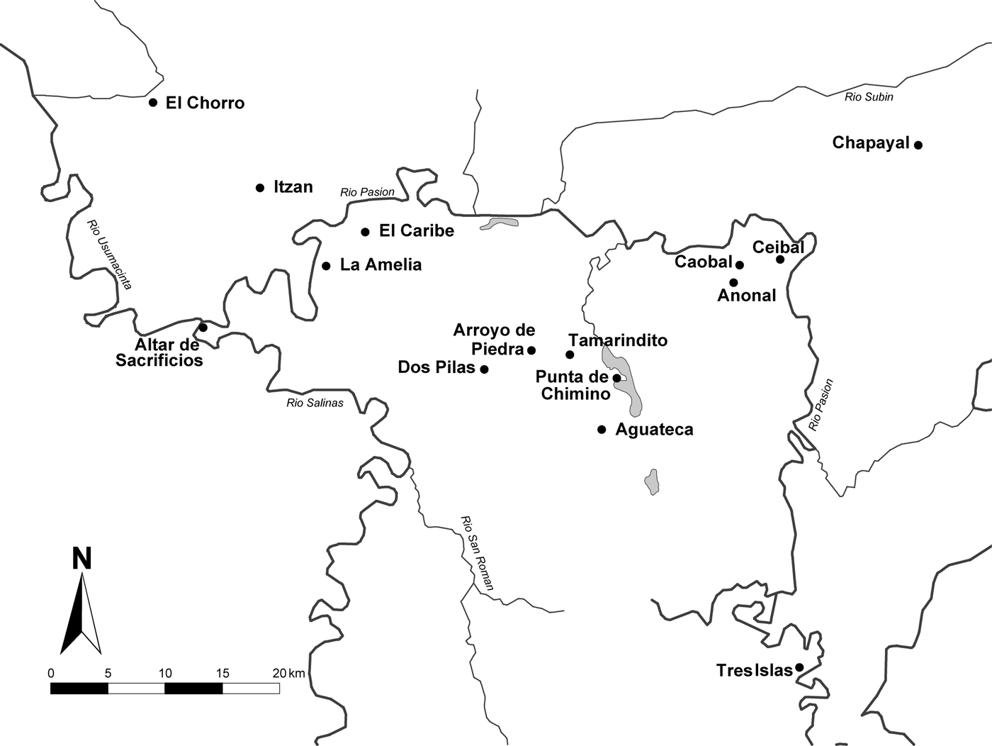
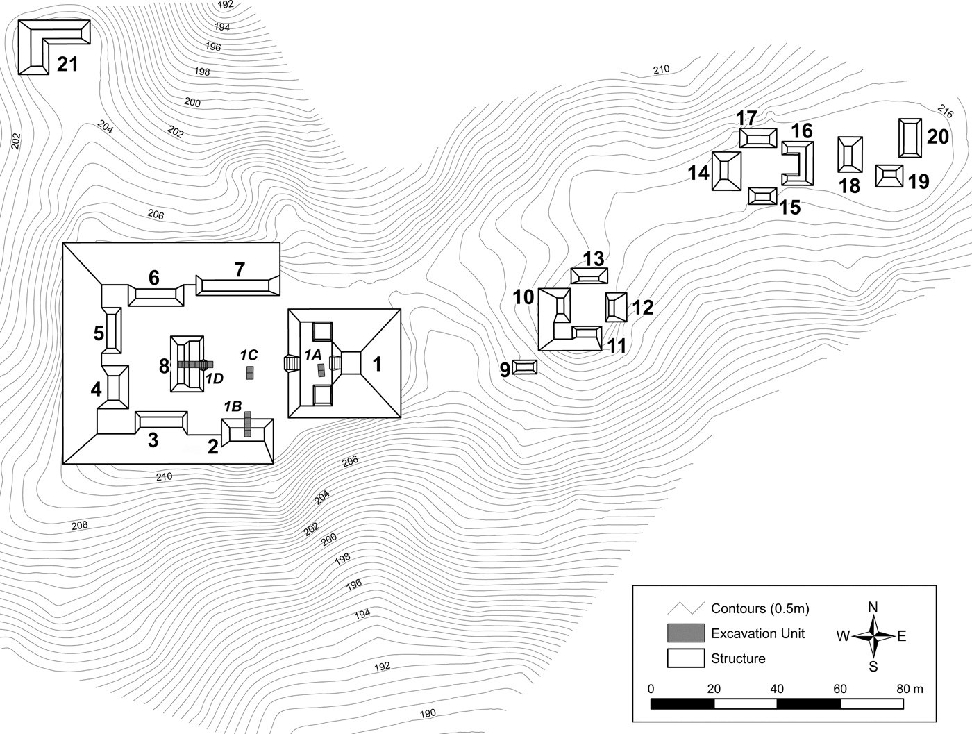
Caobal is a minor ceremonial center located in the periphery of Ceibal's extensively documented settlement in southwestern Peten, Guatemala (Figure 1). This small hilltop site is situated on an outcrop of marl bedrock whose surrounding topography gives way to two natural depressions flanking the northern and southern edges of the site. The settlement is composed of a central precinct, consisting of civic-ceremonial buildings that enclose a single central plaza, and a small residential zone, consisting of at least three house-mound groups to the east as well as a single L-shaped platform located north of the central precinct (Figure 2).
Regional settlement map of sites in the Petexbatun-Pasión region of southwestern Peten, Guatemala. Map by Munson.

Settlement map of Caobal, showing the location of excavation units and operation numbers (in italics). Map by Munson.

Similar to many other minor temple groups previously identified near Ceibal, this cluster of mounds forms a compact arrangement of platforms and pyramidal structures that was likely a local center of habitation and religious activity for dispersed populations. This configuration, however, represents Caobal's final architectural form, as it would have existed at some point prior to abandonment in the ninth century a.d. Similarly, the surface remains and plans of residential groups reflect architectural styles characteristic of the Late and Terminal Classic periods, but provide little indication about Preclassic occupation or the configuration of earlier buildings in the central precinct. Previous research has suggested that these minor temple groups were important nodes of residential organization at Ceibal (Tourtellot Reference Tourtellot1988), although we still do not know when these groups were established or how the growth of these outlying communities changed alongside the development of political authority in the epicenter of Ceibal. This study relies on a detailed intrasite chronology (Munson Reference Munson2015) that examines how pre-Hispanic Maya communities constructed and modified local civic-ceremonial buildings in order to evaluate the way these architectural changes intersected with social changes in the local community of Caobal during the Preclassic period.
MATERIALITY AND TEMPORALITY OF MAYA ARCHITECTURAL TRADITIONS
The organization of ancient Maya settlement has been the subject of intense study because of its implications for social stratification, urbanism, and understanding sociopolitical processes. Archaeological research on the topic has ranged from investigations focused on site-specific settlement mapping (Folan et al. Reference Folan, Kintz and Fletcher1983; Sabloff and Tourtellot Reference Sabloff and Tourtellot1991; Tourtellot Reference Tourtellot1988; Willey et al. Reference Willey, Bullard, Glass and Gifford1965) to regional comparisons and broader-scale architectural patterning (Ashmore Reference Ashmore1991; Ashmore and Sabloff Reference Ashmore and Sabloff2002; Brown and Witschey Reference Brown and Witschey2003; Marcus Reference Marcus1973). The emphasis on settlement for Maya studies can be attributed to Willey's work in the Belize Valley and later investigations at sites in the Pasión region, including Ceibal and Altar de Sacrificios (Willey Reference Willey1973, Reference Willey1990; Willey and Smith Reference Willey and Smith1969; Willey et al. Reference Willey, Bullard, Glass and Gifford1965, Reference Willey, Smith, Tourtellot and Graham1975). In this regard, a major finding from the original Ceibal settlement survey was a number of architectural groups arranged around a central pyramidal structure, which were later dubbed “very minor ceremonial centers” (Tourtellot Reference Tourtellot1988:39–44), are referred to here as minor temple groups or minor centers.
Scholars have suggested on numerous occasions that these architectural complexes were important organizational nodes for dispersed populations in pre-Hispanic Maya society (Becker Reference Becker1999; Bullard Reference Bullard1960; Chase and Chase Reference Chase, Chase, Iannone and Connell2003; Fry Reference Fry1969; Haviland Reference Haviland and Ashmore1981; Iannone Reference Iannone and Garber2004; Lucero Reference Lucero2007; Munson Reference Munson2005; Ringle Reference Ringle, Grove and Joyce1999; Tourtellot Reference Tourtellot1988; Tourtellot et al. Reference Tourtellot, Everson, Hammond, Iannone and Connell2003). In its most general form, minor center refers to small concentrations of architectural features which may include shrines, vaulted buildings, pyramidal structures, plazas, stelae, causeways, and/or ballcourts (Bullard Reference Bullard1960). The more specific reference to minor temple groups implies the presence of pyramidal architecture with a presumed civic-ceremonial function. These terms have been applied to a variety of architectural forms, but the concept denotes a hierarchical relationship as well as social and geographic distance between groups of buildings that may have had quite distinct functional attributes (Chase and Chase Reference Chase, Chase, Iannone and Connell2003). Perhaps in part due to this variability, theories abound regarding the social significance of these architectural clusters.
Although various typologies have been proposed for classifying minor centers (Ashmore Reference Ashmore and Ashmore1981; Bullard Reference Bullard1960; Hammond Reference Hammond1975; Iannone Reference Iannone and Garber2004; Tourtellot Reference Tourtellot1988:277–284), such classifications tend to generate static interpretations of what were undoubtedly multiuse spaces that went through variable phases of construction and abandonment. Recent research emphasizes this point by focusing on the agency of ancient builders as well as the depositional practices that contributed to constructing mounded architecture (Blake Reference Blake and Lesure2011; Joyce Reference Joyce2004; McAnany and Hodder Reference McAnany and Hodder2009; Mills and Walker Reference Mills, Walker, Mills and Walker2008). These latter approaches arguably pay greater attention to the interpretative implications of stratigraphy and chronology for understanding social and material changes associated with ancient built environments. The material remains archaeologists encounter represent cumulative traces of discrete and individual acts that we can disaggregate with variable success. More often, these palimpsests are treated as distinct occupation phases, which may obscure the continuous or discontinuous flow of human action and social memory in and out of architectural spaces. Time has always been an important unit for archaeological analysis, but scholars have begun to recognize different tempos or periodicities as well as the conflation between cyclical and linear time in sequential architectural deposits (Ashmore Reference Ashmore, Iannone and Connell2003:10–11; Joyce Reference Joyce2004; Lucas Reference Lucas2005; McAnany and Hodder Reference McAnany and Hodder2009; Normark Reference Normark2016; Rice Reference Rice2008). This emphasis on temporality draws attention to the dynamic interaction between buildings in variable stages of construction, abandonment, and reuse (Stanton and Magnoni Reference Stanton, Magnoni, Stanton and Magnoni2008). It remains an analytical challenge, however, to correlate multiple episodes of construction at adjacent buildings within a single settlement (Munson Reference Munson2015).
Built environments with long architectural sequences are suitable contexts for investigating the temporality and materiality of ancient architecture because people often acquire or move into structured spaces which they may subsequently modify, demolish, rebuild, renovate or ignore altogether, depending on what suits their current needs. It remains a challenge to not only identify the material remains of these repeated practices but also to interpret how these episodes of construction, renovation, and reuse contributed to social changes in the past. While it may be easy to assume that minor centers like Caobal performed important integrative functions within the community, it is essential to consider how this process unfolded at the local scale. This calls attention to the ways people used and constructed these buildings, as well as how these collective projects contributed to defining and integrating communities through practice (Wenger Reference Wenger1998). By analyzing the pace of and materials used in the construction of minor temple groups beyond the core of Maya centers, we aim to demonstrate how pre-Hispanic communities simultaneously built upon and transformed their social world.
PREVIOUS RESEARCH AT CEIBAL
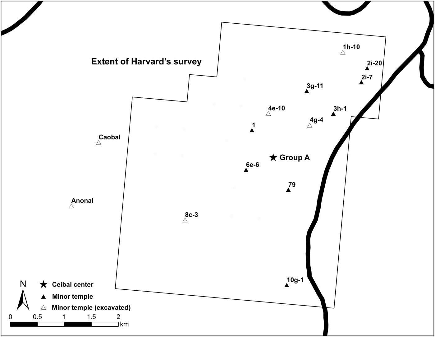
Significant archaeological research has been undertaken in the Petexbatun-Pasion region over the past fifty years (see Demarest Reference Demarest1997; Houston Reference Houston1993; Inomata Reference Inomata1997; Inomata and Triadan Reference Inomata, Triadan and Christie2003, Reference Inomata and Triadan2010; Inomata et al. Reference Inomata, Triadan and Aoyama2017b; Sabloff Reference Sabloff1975; Tourtellot Reference Tourtellot1988; Willey et al. Reference Willey, Smith, Tourtellot and Graham1975). One of the primary objectives of early archaeological investigations at Ceibal was to ascertain the functions of Maya urban centers based on settlement pattern studies (Willey et al. Reference Willey, Smith, Tourtellot and Graham1975:8). Thus, an important component of this project involved survey and excavation of selected architectural units outside the site center led by Tourtellot (Reference Tourtellot1988). The settlement survey covered an area of 20 km2 and used a sampling design based on the traverse technique established at Uaxactun and Tikal (Figure 3; Tourtellot Reference Tourtellot1988:8–11). Excavations were also carried out in a sample of these mapped structures in order to refine the earlier architectural typology of Ceibal and provide a more complete documentation of features associated with these structures (Tourtellot Reference Tourtellot1988:34–38).
Settlement map, showing the distribution of minor temples around Ceibal, including those that were excavated by Tourtellot (Reference Tourtellot1988) and Munson (Reference Munson2012). Map by Munson.

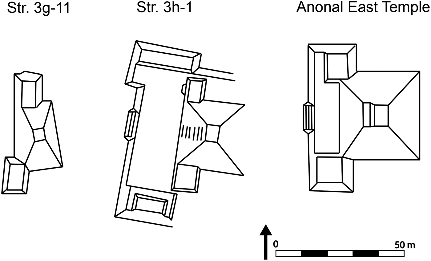
As shown in Figure 3, several minor temples called Class M structures were identified in the original Ceibal survey (Tourtellot Reference Tourtellot1988). These buildings share similar architectural plans and features, including their east-west orientation, flanking low platforms, as well as plastered facades (Figure 4). These are also modest structures in size, ranging from four to 10 meters in height. Many of them are laid out in a similar manner to Caobal: facing west and forming the eastern boundary of a formalized plaza space; although it is important to remember this form represents the latest architectural arrangement of these buildings. Five of the original Class M structures were subject to test excavations by the Harvard project, but in most cases none of the adjacent structures associated with these minor temple groups were excavated beyond mapping the surface architecture. An exception, however, is a group of three structures (1H-8a, 1H-8b, 1H-8c) located on an elevated patio across from temple Structure 1H-10. These three buildings were investigated as part of Operation 140 and were found to be contemporaneous with the west-facing minor temple (Tourtellot Reference Tourtellot1988:169). Since a primary goal of Harvard's settlement survey was to identify specific features associated with the architectural classes being tested, excavations tended to expose only the uppermost levels of these structures. The test pit placed in front of the eastern pyramid at Anonal, however, revealed a stratified sequence of Preclassic and Classic remains, including large quantities of Middle Preclassic ceramics that hint at a very early and continuous occupation of Ceibal's peripheral settlement (Tourtellot Reference Tourtellot1988:183–185). No other units were excavated at Anonal and few of the other minor temple groups were subject to extensive excavation, so we lack the broader contextual evidence needed to infer changes in the overall spatial and social organization of these minor centers.
Selected sample of Class M structures from Ceibal's original settlement survey, showing similarity in architectural form, orientation, and flanking platforms. Drawings by Munson.

INVESTIGATIONS AT CAOBAL
Caobal was first discovered in 2006 while recording minor ceremonial centers originally documented by Harvard's investigations at Ceibal (Munson Reference Munson2006). Tourtellot's (Reference Tourtellot1988) survey identified 13 minor temple sites in the Ceibal periphery, including the small and neighboring ceremonial-administrative center called Anonal located just 1.4 km south of Caobal (see Figure 3). Anonal lies outside of Tourtellot's original survey grid, but was first discovered during road-building operations in Harvard's last field season at Ceibal (Willey et al. Reference Willey, Smith, Tourtellot and Graham1975:46). A reconnaissance trip to relocate Anonal and other minor temple sites near Ceibal resulted in the discovery of a previously undocumented group of mounds now identified by the name Caobal (Munson and Inomata Reference Munson and Takeshi2011).
Caobal is situated approximately 3.2 kilometers west of Ceibal's Group A and is defined by a small cluster of civic and residential structures (see Figures 1 and 2). The central precinct is a dense architectural complex built on top of a natural rise on the western edge of the site and was the focus of extensive investigations under the current project. This sector of the site is identified by a medium-sized pyramidal mound and seven smaller mounds, which form a compact plaza measuring approximately 50 × 20 meters. The group is oriented along an east-west axis and planned around the focal point of Structure 1, the largest mound. The basal platform of Structure 1 measures 35 × 35 m and stands nearly nine meters tall. This pyramidal mound is composed of two terraced levels that are connected by a central staircase on the building's west side leading down to the plaza level. The upper terrace is flanked on either side by two low platforms, which form a sort of triadic complex for the temple building's final form.
Various-sized mounds on the remaining north, south, and west sides of the main plaza define the central precinct at Caobal. The next tallest mound, Structure 2, stands approximately 2.5 meters tall and forms part of the southern edge of the plaza. On the north side of the plaza, Structure 7 occupies the longest and lowest architectural position measuring about 26 meters long and is less than one meter tall. Across from one another, Structures 3 and 6 are similarly sized platforms standing about 1.5 meters tall and measuring 16 × 7 m and 17 × 6.5 m, respectively. Structures 4 and 5 enclose the west side of the plaza, measuring 13.5 × 8.5 m and 14.8 × 6.1 m, respectively. There was no evidence of standing walls or room divisions on any of the platform mounds enclosing the plaza, suggesting that some of them may have been the foundation for perishable structures. Structure 8 is a large terraced platform located in the center of the main plaza, facing Structure 1. This building divides the plaza into two sectors—a larger eastern sector identified as a public space for communal gathering and ritual, and a smaller western sector which was not investigated beyond topographic mapping.
Investigations at Caobal were conducted over three field seasons (2006, 2008–2009) with the objective of examining continuities and changes in the material record and settlement history of this minor temple site. Fieldwork included detailed topographic mapping, test pitting in various parts of the site, extensive excavations of multiple structures in the temple precinct, as well as recording and stabilizing trenches caused by previous looting activity (Munson Reference Munson2012). With the goal of uncovering the complete architectural sequence for buildings in the central precinct, three excavation units were placed along the central axes of Structure 1 (Operation 1A), Structure 2 (Operation 1B) and Structure 8 (Operation 1D), while a fourth (Operation 1C) was located in the eastern sector of the main plaza (see Figure 2). Excavations emphasized vertical exposure and documentation of each construction episode to bedrock in all sub-operations; such a strategy is advantageous for exposing deeply buried stratigraphic levels, but is recognizably limited in its ability to reveal broad exposure and interpretation of architectural features.
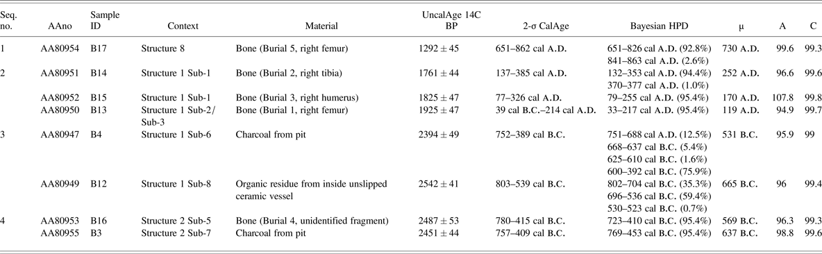
We obtained reliable stratigraphic information about the sequence of construction from each excavated structure, but faced several challenges for evaluating intrasite spatial variation and establishing a fine-grained chronology of architectural changes within the central precinct. A primary issue relates to the mixed nature of these deposits. Many of the deposits were composed of architectural construction fill containing secondary ceramic refuse, which resulted in poor preservation of common diagnostic types as well as some stratigraphic inversions using traditional seriation methods (Munson Reference Munson2012:222–224). Another confounding issue has to do with the precision of the radiocarbon curve between 2800 and 2400 years BP. Although we have an adequate sample of radiocarbon samples from Preclassic contexts (Table 1), several of these come from non-adjacent units so Bayesian modeling of the dates does little to reduce the large error bars associated with flattening of the radiocarbon curve during this period (Munson Reference Munson2012:237–253).
Bayesian-modeled radiometric determinations from Caobal. Adapted from Munson Reference Munson2012:237–253.

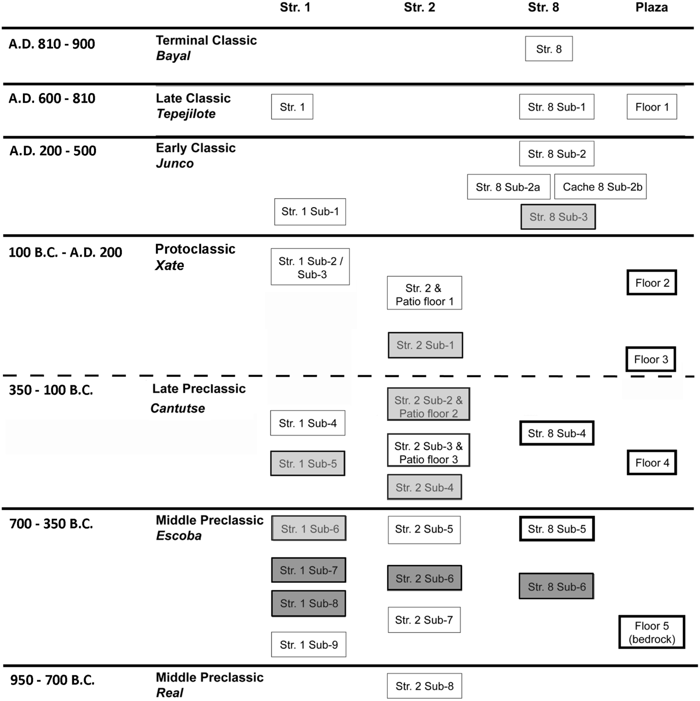
To overcome the limitations of traditional chronological assessment, a network-based cluster analysis was used to develop a fine-grained site chronology using diagnostic ceramic types and selected variables (e.g., artifact density, type of architectural fill used, and concentration of shells) to characterize the composition of each deposit (Munson Reference Munson2015). Given the assumption that deposits composed of a similar matrix are more likely to have formed under similar spatiotemporal conditions, these additional variables represent the cumulative actions associated with each construction event, including the selection and preparation of primary building materials, identification of resources (i.e., middens) for secondary fill material, and other activities either directly or indirectly related to these construction events. In order to minimize potential confounding effects due to formation processes and the mixing of old material into later deposits, only those assemblages dated to the Preclassic were included in the cluster analysis. Results from the cluster analysis produced three distinct groups of deposits based on compositional similarities (see Munson Reference Munson2015:452–455). By combining the known stratigraphic relationships of individual excavation units with the groupings resulting from the cluster analysis, we gain a better understanding of the relationships between construction episodes at discrete loci and can begin to reconstruct the sequence of architectural changes within the built environment (Figure 5).
Stratigraphic and intra-site spatial relationships between adjacent deposits excavated in the central precinct of Caobal, based on Munson (Reference Munson2012, Reference Munson2015). Dark grey units are approximately contemporaneous deposits of similar earthen-refuse fills; light grey units represent similar compositional deposits of plaster; and heavy black outlined units represent architectural surfaces such as plaza and patio floors presumably formed via processes (i.e., accumulation) other than construction of the building platforms. Other assemblages were ordered based on stratigraphic position and assigned phases based on ceramic analysis and radiometric determinations. Chart by Munson.

CONSTRUCTION HISTORY OF A MINOR TEMPLE CENTER
Despite the modest size and compact layout of Caobal's central precinct, there is evidence for significant construction activity beginning in the Middle Preclassic period and continuing through the Classic period. The intensity of construction, application of certain architectural technologies, and focus of ritual activity, however, changed markedly throughout this time, especially during the Preclassic period. In the remainder of this paper we highlight two key transitions in the construction of civic-ceremonial architecture along with corresponding changes in community organization.
Living Surfaces
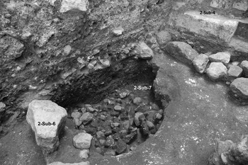
Early settlers of Caobal established this site as a domestic settlement during the early Middle Preclassic period based on the identification of habitation loci and the accumulation of refuse material on the bedrock surface. Unlike the extensive sequence of early Real floors documented in Group A at Ceibal (Castillo and Cortave Reference Castillo, Cortave, Román, Inomata and Triadan2009, Reference Castillo, Cortave, Román and Inomata2010; Castillo Aguilar and Sal Ávila Reference Castillo Aguilar, Ávila, Aguilar and Inomata2011; Inomata et al. Reference Inomata, Triadan, Aoyama, Aguilar and Yonenobu2013, Reference Inomata, Triadan and Aoyama2017a) there is no architectural evidence for construction activities earlier than the Real 3 phase at Caobal (see Inomata et al. Reference Inomata, Triadan and Aoyama2017a). Rather, the earliest evidence of landscape modification both at Caobal and Ceibal appears to have been the clearing of old topsoil to expose the natural bedrock as a living surface. This practice is similar to habitation patterns found at other early Maya villages and is perhaps one reason why there is little evidence of pre-ceramic occupation at these settlements (see Lohse Reference Lohse2010). At Caobal, we found evidence for expansive clearing of the natural soil in Operations 1A, 1B, and 1C where accumulations of domestic debris were found trampled into the upper few centimeters of the soft marl bedrock. There is additional evidence to suggest that early residents deposited refuse in large pit features and incorporated domestic debris into later construction fills. A large circular pit (2-Sub-7) found on the south side of the plaza, measuring1.6 m in diameter and 0.5 m deep, was filled with dark loose soil, river cobbles with evidence for fire-cracking and alteration, along with ceramics, lithics, shell and mammal bone fragments (Figure 6). Although little is known about the domestic or ritual practices of these early inhabitants, it appears these residents procured locally available riverine resources and were engaged in interregional trade relationships perhaps mediated by incipient elites at Ceibal (Aoyama and Munson Reference Aoyama and Munson2012).
Photograph of large trash pit (2-Sub-7) used for the deposition of domestic debris, including ceramic fragments, chert and obsidian flakes, abundant quantities of freshwater snails (Pomacea sp.), river bivalves, and modest quantities of burned mammal bone. Photography by Munson.

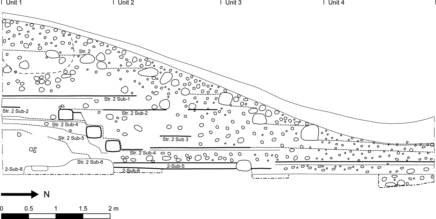
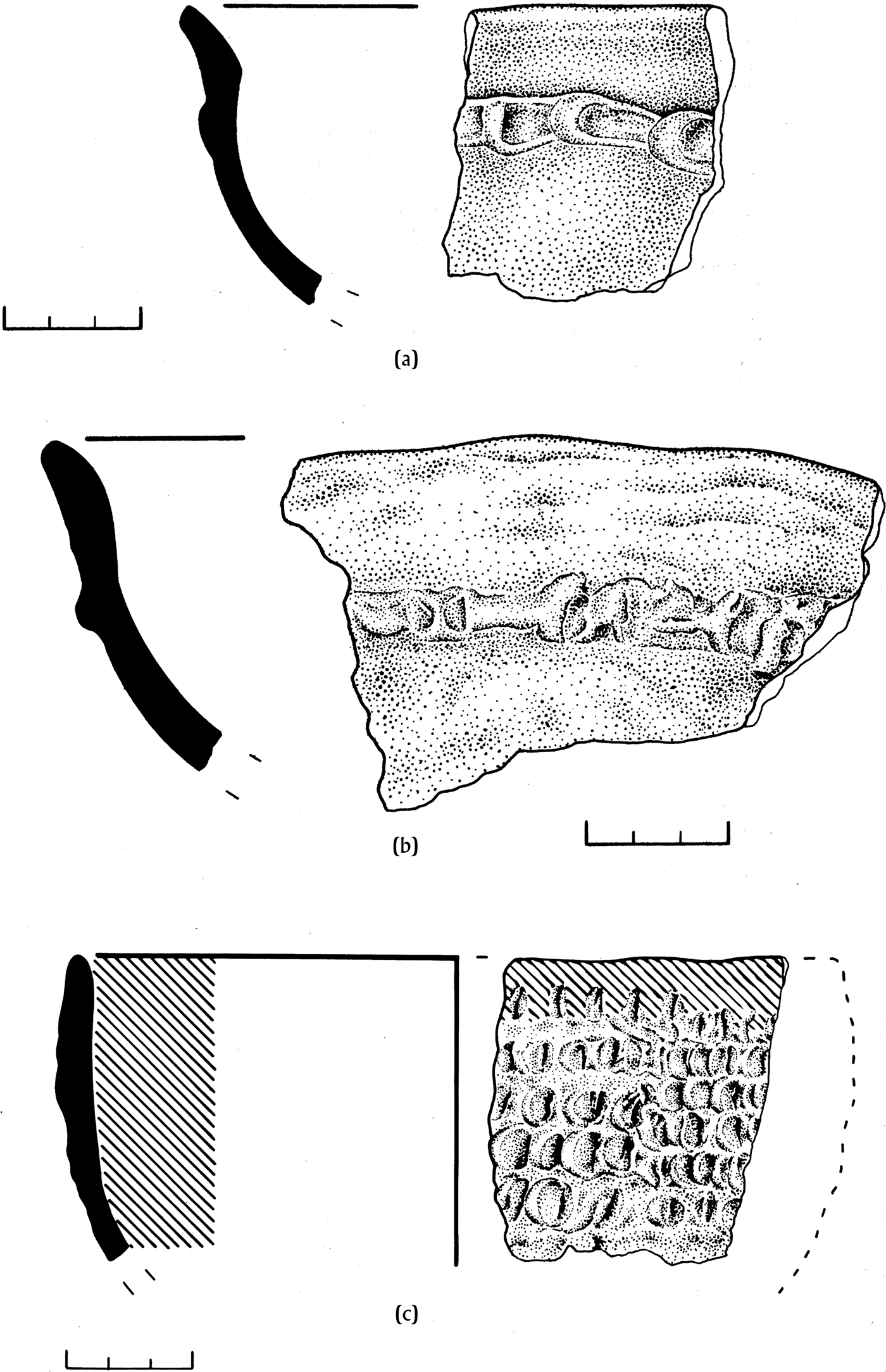
The large pit feature and quantity of trash found in construction fills suggests a modest sedentary population during the earliest phase of occupation. Three postholes dug into bedrock beneath Structure 1 likely supported a pole-and-thatch style structure, providing direct evidence for some of the earliest permanent occupation at Caobal. Although no diagnostic artifacts were found in direct association with these architectural features, a dense scatter of ceramics found in the lowest level of Operation 1B contained types representative of the Real 2 phase (Figure 7) and significant quantities of Real 3 ceramic types were found in deposits overlying bedrock in Operation 1A and 1C (Figure 8). Given the types and density of ceramic artifacts found in these levels, Caobal appears to have been settled sometime between 850–700 b.c.
Profile drawing of Structure 2, showing stratigraphic relationship between construction layers. Drawing by Munson.

Drawings of impressed fingernail decoration from selected Real 3 ceramic types: (a–b) Balidzon Impressed and (c) Yalmanchac Impressed. All examples are from the construction fill of Structure 1-Sub 8. Drawings by Alfredo Román.

Earthen Architecture
One of the most striking observations of Caobal's settlement history is the consistency in architectural forms and general layout of buildings in the central precinct. Although it appears this settlement initially had a domestic focus, subsequent occupants used the footprint of earlier activity areas and habitation sites to construct raised platforms and pyramidal architecture, defining a civic-ceremonial architectural complex at this hilltop site. The initial stages of platform construction mark the first stage in the transition to more permanent settlement and the establishment of standard architectural practices during the late Middle Preclassic period.
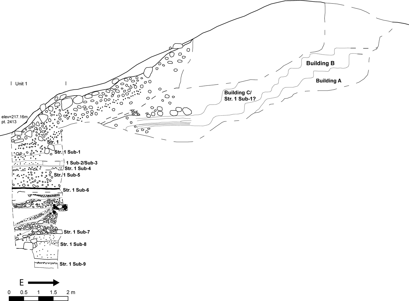
Low boulder-walled platforms constructed from dark earthen sediment with high clay content and abundant cultural debris are common in the first half of the Escoba phase (see Figure 5). Portions of three such platforms (1-Sub-8, 2-Sub-6, and 8-Sub-5) were discovered during excavations and appear to have been used, if not constructed, at about the same time based on similarities between the composition of fill, diagnostic ceramic artifacts, and absolute elevation (Munson Reference Munson2015). A low rectangular-shaped earthen platform (8-Sub-6) was constructed just above bedrock on the western side of the plaza during the first half of the Escoba phase. This platform was raised with a single course of large flat boulders and filled with a mixture of silty clay and moderate quantities of refuse. Another low earthen platform (2-Sub-6) marked by stone alignments was constructed in the southern part of the site around the same time. This raised platform created an elevated habitation surface where a small circular stone-lined pit was found on a greasy clay surface along with ash and scattered refuse. A third raised platform (1-Sub-8) constructed from a single course of large boulders was filled with domestic refuse and leveled with a clay floor sometime around the mid-seventh century b.c. (Figure 9). It is possible this structure may have been apsidal or circular in form, similar to the contemporaneous circular platform named Kotko at Ceibal (Castillo and Cortave Reference Castillo, Cortave, Román, Inomata and Triadan2009) and other Middle Preclassic platforms excavated from sites in various parts of the Maya lowlands (Aimers et al. Reference Aimers, Powis and Awe2000; Hammond et al. Reference Hammond, Gerhardt, Donaghey and Hammond1991; McAnany Reference McAnany and McAnany2004). The presence of domestic refuse recovered from the construction fill of 1-Sub-8 and abundant quantities of snail shells (Pomacea sp.) found in a concentrated deposit near the platform's surface point to some of the common discard and recycling practices associated with the construction process.
Profile drawing of Structure 1, showing stratigraphic relationships between construction layers. Drawing by Munson.

Similar materials and construction practices contributed to raising these low platforms to build the earliest pyramidal mounds at Caobal. Flanking the southern edge of the plaza was an earthen stepped platform (2-Sub-5) containing a disarticulated and highly fragmented human burial accompanied by numerous marine shell beads (Munson Reference Munson2012:452–453). Other notable findings in this earthen mound included a modeled figurine fragment depicting three bird-like creatures, circular worked sherds, and ceramic fragments with appliqued spikes. Although spiked censers may be more common during the Late Preclassic, similar ceramic fragments have been found at various sites during the Middle Preclassic, including Ceibal and Altar de Sacrificios (Adams Reference Adams1971:Figure 9i; Grove and Gillespie Reference Grove, Gillespie and Plunket1998; Laporte Reference Laporte2007:36; Sabloff Reference Sabloff1975:60), suggesting that rituals associated with censers or urns were common in the greater Pasión region during this time.
The construction of a large terraced mound (Building A) atop another earthen platform (1-Sub-7) on the eastern edge of the plaza dominates this newly formed central precinct. During the early Escoba phase, a raised platform, defined by a north-south alignment of large flat rectangular stones filled with dense refuse and finished with a fine layer of brown clay, was constructed over 1-Sub-8 (see Figure 9). Although there is no contiguous stratigraphic relationship between Building A and 1-Sub-7, these two architectural features are the latest earthen constructions beneath Structure 1, and are, thus, likely contemporaneous. Once completed, this early terraced mound would have been an impressive earthen pyramid towering 6 m above the plaza level. The construction of these mounds over low residential platforms represents the initial transition to less quotidian architectural and ritual practices within the central precinct no later than the sixth century b.c.
Although modest in size, the community of Caobal became heavily invested in the construction and renovation of pyramidal temple architecture during the Middle Preclassic period. Although it is possible that earlier mounds were constructed beneath Building A, it seems this site was initially a residential setting that was subsequently transformed into a more formalized architectural complex for communal gatherings and public ritual. The quantity of refuse incorporated into the fill of this pyramidal mound suggests the collective participation that contributed to the construction of these early temple structures.
Platform Expansion
The transformation of Caobal from a humble settlement with semi-perishable architecture to a more formal space with civic-ceremonial architecture was accomplished through repeated episodes of construction in addition to architectural techniques. The introduction of plaster marks the second major transition in the construction of this early Maya community. Several plaster platforms were constructed over earlier earthen mounds using alternating deposits of marl and reddish-yellow sandy clay procured from the local bedrock. These surfaces were sealed with thick layers of plaster, which would have required substantial increases in labor and resources to produce.
The eastern terraced platform (1-Sub-6) was the first structure to be substantially remodeled with this new plaster technology. This platform was raised 1.5 m in a single construction event using alternating deposits of tamped marl and reddish-yellow clay with cobbles (see Figure 9). Although the resulting discontinuous layers may suggest periodic renovation and gradual expansion of this platform, observation of the compacted marl surfaces in thin section indicate these were never sealed with plaster or exposed to the elements for extended periods of time (Munson Reference Munson2012:479–480). A sealed pit containing burned rocks and large fragments of charcoal was discovered in the middle of these fill deposits, providing additional evidence that platform constructed occurred as a single planned event (see Figure 9). The Bayesian calibrated radiocarbon age of 600–392 cal b.c. (p = 0.759) obtained from charcoal in this pit secures the date of platform construction to the latter part of the Escoba phase (see Table 1). This late Middle Preclassic date overlaps with the construction of another expansive plastered platform called the Kaq platform in front of Structure A-24 at Ceibal (Castillo and Cortave Reference Castillo, Cortave, Román, Inomata and Triadan2009; Inomata et al. Reference Inomata, Triadan, Román, Aoyama, Román, Inomata and Triadan2009, Reference Inomata, Triadan, Aoyama, Aguilar and Yonenobu2013). Prior to these major platform renovations, there was a period of intensive occupation marked by a sequence of numerous low clay and stone-walled platforms. The construction of new plaster platforms over these earthen floors represents a significant shift—not only in terms of labor and building technology, but also with regards to the ways these new structures facilitated more restricted interactions as discussed in more detail below.
At Caobal, a new pyramidal structure (Building B) appears to have been constructed on top of the newly plastered basal platform (1-Sub-6), covering the earlier earthen mound. The trench profile reveals this structure was superimposed on Building A, following the same orientation and terraced form as its predecessor (see Figure 9). Further investigation through horizontal expansion or tunneling into the mound was not possible, however, due to loose and unstable fill and, as such, determining the precise building sequence and contiguity between the basal platform and the superstructure were not feasible. Nonetheless, similarities in the color and texture of the construction fills, as well as the presence of earthen architecture beneath Building B and 1-Sub-6 suggest these were coterminous building projects. It also appears this new pyramidal superstructure (Building B) was finished with a coat of plaster similar to the platform surface of 1-Sub-6. It is worth noting that this pyramidal superstructure remained a durable feature on the landscape for several centuries based on stratigraphy, observations of the plaster surface in thin section, and correlations of radiometric dates with Ceibal (Munson Reference Munson2012:324–325, 476–481). Although the overall size of the pyramidal superstructure did not significantly increase during this renovation, the new construction style, materials, and platform expansion indicate major shifts in labor specialization and architectural technology employed by this growing community.
Construction activities during the first half of the Late Preclassic period transformed the central precinct into a more formal architectural complex with the standardized construction of plaster platforms delimiting the plaza center, thus providing an enclosed and more restricted space in front of the long-standing pyramidal temple Building B. Evidence from adjacent structures and plaza floor fills indicate that substantial building activity took place at this time. Although these new buildings replicate the basic layout and form of earlier earthen mound constructions, the scale and style of architectural elaboration of these plastered buildings appears to have aided in the transformation of this civic space. The construction of Structure 2-Sub 4 illustrates this point. Large rectangular blocks of chalky marl were hewn from bedrock, placed directly atop the earthen steps of 2-Sub-5, and cemented together with sandy clay marl (see Figure 7). A layer of plaster was also applied to the patio in front of this building to create a level open space. The steps and patio were covered in a thick coat of plaster and painted red, but were subsequently burned perhaps marking the ritual termination of this structure at a later date. While the function of this terraced platform remains undetermined, the use of plaster, separately processed mortar, and the standardized form of compacted marl blocks could indicate increasing specialization in plaster production and emerging social divisions as suggested by similar technological changes in Preclassic architecture from other lowland Maya sites (Hansen Reference Hansen2000).
Following the delimitation of the central precinct by expanded plastered platforms, a period of renewed temple construction was initiated that lasted through the Junco 1 phase. Platform renovations and modest ritual offerings accompanied these repeated episodes of construction, while new burial practices in the temple platform reflect changing ritual practices in the central precinct. The original plastered basal platform (1-Sub-6) was also severely burned prior to renovation, perhaps in conjunction with the ritual termination of Structure 2-Sub 4. Subsequent renovations to the temple platform were completed using the same technique of plastering and alternating use of fill deposits, although these layers were not as substantial and only thin veneers of plaster coating were added to the surface, suggesting that these were not major remodeling events like that of 1-Sub-6.
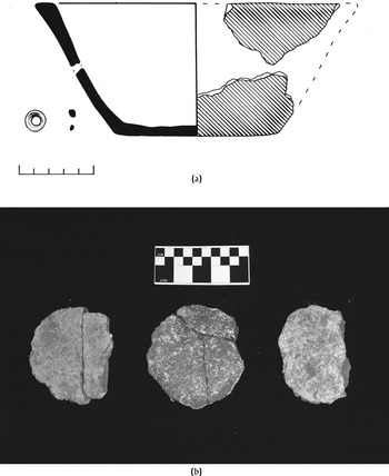
Several offerings were also made in conjunction with these renovations, including three circular worked sherds placed along the central axis of 1-Sub-5 and a simple red-slipped cache vessel containing a jade bead deposited during the construction of 1-Sub-2/Sub-3 (Figure 10). A series of dedicatory burials placed in front of this ceremonial building, associated with construction episodes 1-Sub-2/Sub-3 and 1-Sub-1, suggest further evidence for changes in ritual activity associated with emerging local leaders by the beginning of the Early Classic period (Munson Reference Munson2012:449–455). The modest quality of these ritual offerings and lack of burial goods, however, suggests that elite involvement may not have been essential to the completion of civic architectural projects. There is little evidence to suggest that early temple platforms and mounded architecture were linked to the authority of specific individuals, although leaders surely emerged in particular social situations. Additionally, the durability and longevity of the earliest plastered platform and pyramidal structure (1-Sub-6) at Caobal suggests an extended period of stability within this community, attesting to the historical and cultural importance of these architectural features.
Cache deposits recovered from the construction fill of: (a) Structures 1-Sub 2/Sub 3, containing a jade bead and a Caribal Red cache vessel lid (drawing by Alfredo Román); (b) 1-Sub-4, containing three worked sherds placed as a dedication along the central axis and floor of the structure (photograph by Munson).

CREATING COMMUNITY THROUGH REPEATED PRACTICE
This study regards the built environment, particularly civic-ceremonial architecture, as an important context for examining social and political changes associated with the development of early Maya communities. Rather than focusing on the final materialized form of these structures, we consider the acts and materiality of construction itself to be significant practices that contributed to the creation of this community. The construction materials, technology, organization of labor, and underlying motives for building large civic-ceremonial structures are carefully examined in relation to earlier and later episodes of construction to discuss how the temporality and materiality of temple architecture facilitated varied social interactions.
Although the archaeological signature of these construction events may imply punctuated changes in the architectural form and layout of Caobal's central precinct, this does not necessary reflect episodic social change. Rather, the materiality and repeated building practices that defined this architectural complex offer clues to how these social processes unfolded over long periods of time.
The construction of earthen-mound architecture far from the epicenter of major Maya sites during the Middle Preclassic period points to the autonomy of these communities and the central importance of religion for establishing social bonds from a very early time. Although the earliest domestic features provide little evidence for social differences at this time, inequalities are likely and could have been based on principles of primogeniture as suggested for other early Maya villages (McAnany Reference McAnany1995). Pyramidal earthen mounds constructed over these early residential platforms represent the transformation of this small settlement into a modest ceremonial center during the first half of the Middle Preclassic period. These architectural projects were accomplished using rather informal techniques and readily available building materials. Such quotidian practices suggest this was a communal effort that may have been subsidized by religious rationales. The juxtaposition of domestic refuse in the fill of these civic buildings further points to the collective participation necessary for early mound construction.
The shift from earthen construction materials to plaster represents a marked change in the degree of specialization required to formalize this architectural complex. It is especially significant that this new construction technique was first applied to temple architecture and then to more quotidian structures. The introduction of plaster technology at Caobal signals the formalization of monumental architectural traditions and religious practices during the late Middle Preclassic period, although it is unclear what role early communal leaders played in the construction of these buildings and new sanctified traditions. Nonetheless, this durable temple platform points to a period of stability and implied continuity in religious practice for several centuries. Such an enduring spatial framework may have produced the type of social landscape in which collective memories could operate and promote acceptance of supernatural metaphors (Connerton Reference Connerton1989:37; Ringle Reference Ringle, Grove and Joyce1999). That is, the inheritance and unchanging structure of Caobal's Middle Preclassic ceremonial center may have facilitated instances of recollection about past people, events, or ideas that were fundamental to new positions of power later in the Preclassic period.
While the earliest plastered public building may have solidified communal ideals and formalized ritual practices, the durability and permanence of this temple platform could have figured centrally in subsequent competitive displays and local power contests. At Caobal these negotiations are apparent through repeated episodes of construction and the shift in dedicatory burial practices by the beginning of the Early Classic period. The high frequency of reconstruction and consistency in building techniques suggests that community members were actively engaged in the recollection of individuals or earlier events associated with this building, as they replicated the basic form and layout of earlier platforms. These sequential platform renovations, however, created more restricted access to the temple precinct and ceremonies that took place in Caobal's main plaza. This pattern of restricted ceremonial space is repeated at a number of Pasión centers around this time (Bachand Reference Bachand2010; Johnston Reference Johnston2006; Smith Reference Smith1972) albeit in variant architectural forms. The dedicatory burial practices associated with Caobal's renovated temple platform further imply new expressions of corporeal, as opposed to supernatural, power. Such circumscribed ceremonies indicate that ritual practice was becoming increasingly differentiated and participation limited to certain social groups. The large central plaza in Ceibal's Group A, however, likely remained the focus of ceremonial activity at this time for the wider population. These architectural changes seem to parallel the introduction of new ceramic styles and monumental sculpture to the Pasión region, but the precise timing and distribution of these phenomena are still not well understood. Indeed, the transition from the Preclassic to Early Classic period was a time of dynamic social and political change, both locally at Caobal and in the broader Pasión region, and deserves additional investigation.
CONCLUSION
Investigations at Caobal have revealed a long and detailed record of occupation and architectural changes at a small ceremonial center located in the southern Maya lowlands. Caobal grew from an ephemeral hamlet into a formal civic arena for the local population throughout the Preclassic period. Although certain aspects of the settlement layout and repeated episodes of construction imply a degree of continuity for defining architectural traditions, we see how the reproduction of these traditions modify social relationships within the community. Despite the long history of architectural and social transformations documented by this research, the nature of the archaeological record from which these continuities and changes are interpreted is but a small window into the complex relationships between periphery and center, public and private, high status and less privileged, as well as past and present in pre-Hispanic Maya society. Precisely because the pre-Hispanic Maya constructed their temples and houses over previous buildings, excavating and interpreting the extent of these early settlements remains extremely difficult. Nonetheless, this small window provides a sharply focused glimpse into these social, political, and material transformations as they unfolded under specific historical circumstances.
Tracing the development of Preclassic architectural traditions from this forward-looking perspective allows us to consider the consequences of building big (Joyce Reference Joyce2004). Continuities in settlement layout and repeated episodes of construction at Caobal demonstrate that this community created and maintained social and political relationships with this place over a long period of time. Especially for Caobal's Preclassic occupation, however, these repeated practices also reflect social transformations as people negotiated new relations of power and meaning associated with the buildings and practices that took place in these spaces. Importantly, this process involved more than a basic building program. Groups established social relationships and negotiated new social roles through daily and ritual practices that were intimately linked to this place. The repeated acts and shared experiences that accompanied these building projects routinely created and re-established these community ties. Although we may never know the precise motivation for choosing this particular hilltop site on which to build a few platforms and earthen pyramid, we can study those acts and contexts that contributed to making this place a central focus of communal activity and religious practice for many generations.
RESUMEN
Las investigaciones arqueológicas en el centro menor de Caobal proveen datos relevantes sobre las tradiciones locales de la arquitectura cívica-ceremonial, como la relación entre estos edificios y las trasformaciones sociales y políticas durante el periodo preclásico. Los remanentes de la arquitectura maya prehispánica representan una serie de acciones, decisiones y prácticas repetitivas que contribuyen a largas secuencias de construcción observadas en una serie de estudios arqueológicos. En particular, estos datos sacan a luz a dos edificios mayores que tomaron lugar dentro del centro de Caobal desde aproximadamente 850 a.C.–250 d.C. Con el estudio de los materiales y la temporalidad de la arquitectura de templos menores más allá de los centros de poder primarios, hemos examinado cómo estos edificios fueron construidos y en consecuencia cómo estas construcciones pudieron haber transformado las prácticas diarias, identificación política y los valores religiosos de las comunidades mayas prehispánicas. La subsecuente construcción de edificios en Caobal proveen un largo y detallado record arqueológico que nos permite reconstruir la historia de las prácticas sociales y materiales que conformaron esta comunidad más allá del centro Ceibal.
ACKNOWLEDGEMENTS
We are grateful to the directors of the Ceibal-Petexbatun Archaeological Project, Takeshi Inomata and Daniela Triadan, for their support, mentorship, and encouragement. We are deeply indebted to the directors and other personnel of the Instituto de Antropología e Historia de Guatemala for the permit to work at Ceibal and Caobal. Our thanks to Prof. Kazuo Aoyama, Estela Pinto Gonzalez, Kenichiro Tsukamoto, Juan Manuel Palomo, Ashley Sharpe, Mónica Cortave, Manuel Alejandro de León, Omar Schwendener, David Trautman, Matthew Vaccaro, Maren Hopkins and Jonathan Scholnick for their contributions to the fieldwork and laboratory analysis. Arthur Demarest and William Ringle are also recognized for their helpful comments on an earlier version of this paper. Any errors of fact or interpretation remain our own. Research at Caobal was funded by the National Science Foundation (Doctoral Dissertation Improvement Grant BCS-0837536), a Junior Fellowship at Dumbarton Oaks, and the Schools of Anthropology and Social and Behavioral Sciences at University of Arizona.