INTRODUCTION
It is often the case that modern highway routes coincide with settlements and other sites from antiquity, given that geophysical characteristics judged favorable for modern highway construction were likewise considered favorable factors for settlement and construction in ancient times (Pulido and Grave Reference Pulido Méndez, Grave Tirado, Wario and Staedtler2005). Hence archaeological remains will likely be endangered whenever highway construction is contemplated. One such case is the so-called “Arco Norte,” or Carretera Libramiento Norte de la Ciudad de Mexico, a four-lane highway that crosses parts of the modern states of Mexico, Hidalgo, and Tlaxcala. The portion that includes Hidalgo traverses a diverse landscape that was home to a wide variety of indigenous settlements dating from before the beginning of the Christian era to the Spanish conquest, as well as Novohispanic occupation from the colonial and historical periods, and even more recently abandoned sites.
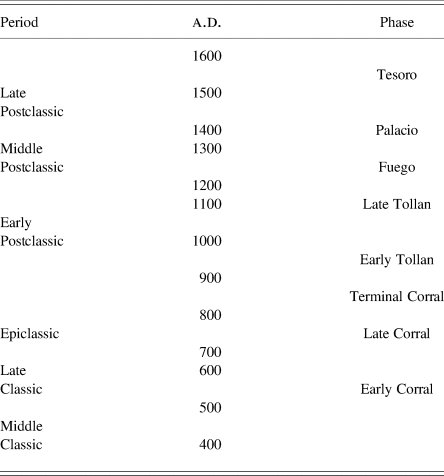
The proposed construction of the Arco Norte led to a program of intervention by the Dirección de Salvamento Arqueológico of the Instituto Nacional de Antropología e Historia (INAH), to assess, register, and in some cases protect the archaeological heritage along the proposed route, which in the state of Hidalgo included the site of Tula, the ruins of the ancient city Tollan Xicocotitlán, which rose to prominence during the Early Postclassic period (Table 1). Indeed, the proposed right of way traverses the northern portion of the ancient city (Figure 1), which led to the creation of the Proyecto de Salvamento Arqueológico en la Carretera de Libramiento Norte de la Ciudad de México (hereafter Proyecto ZUN [Zona Urban Norte]), the program of survey and salvage excavations that are the subject of this article.
Revised chronology for Tula and the Tula region (after Healan et al. Reference Healan, Cobean and Bowsher2021).

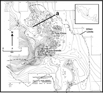
Map of the Tula urban zone, showing the distribution of mounds more than 1 m in elevation (Yadeun Reference Yadeun and Moctezuma1974) and (a) the location of the Arco Norte right of way included in the Proyecto Zona Urbana Norte (ZUN).

Taking advantage of the inherently linear nature of highway construction projects, the investigation took the form of a 1.4-km transect across the northern part of the ancient city (Figures 1 and 2), thus providing an opportunity to systematically investigate a segment of the ancient city that was previously unknown, i.e., the area located near its northern limits. As detailed below, systematic survey followed by exploratory excavation and ultimately extensive excavation in selected localities revealed a pattern of settlement like that seen in the urban core, featuring a diversity of structures and associated activities and institutions believed to reflect the totality of life at the barrio level. In addition, these investigations have shed additional light on both Tula's earliest and latest settlement history, two aspects of the ancient city that have only recently begun to be understood.
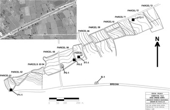
Distribution of agricultural plots (parcels, or parcelas) along the Arco Norte right of way and the five localities where extensive excavations were conducted. Path of current highway is shown in inset. Google Earth imagery; drawing by Alfredo Reyes Castro.

BACKGROUND
Tula is located on the northern flank of the Basin of Mexico, an area with a long tradition of large cities and civilizations that included Classic period Teotihuacan and Tenochtitlan, capital of the Late Postclassic Aztec Empire. The Tula region is a topographically diverse area of mountains, hills, river valleys, and a large alluvial plain that currently supports intensive agriculture irrigated by modern canals and the Tula and Salado rivers, including systems that may have their origins in the prehispanic era. In the same way, many of the existing roads follow older routes that connected Tula to surrounding towns, at least as early as the colonial era.
Prehispanic sdettlement in the Tula region spans a period of at least a millennium (Table 1), beginning in the Classic period Chingú phase with what appears to have been the colonization of the region by Teotihuacan featuring the appearance of numerous settlements in the alluvial plain (Mastache et al. Reference Mastache, Cobean and Healan2002:51–76). However, there was also settlement in the region by other peoples associated with Coyotlatelco ceramics, whose origins can be traced to the eastern Bajío (Hernández and Healan Reference Hernández, Healan and Beekman2019). This included the initial settlement of Tula during the Early Corral phase, with the appearance of settlement associated with the monumental center known as Tula Chico (Figure 1; see Cobean et al. Reference Cobean, Healan and Suárez2021). During the Early and Late Tollan phases, Tula grew to a size of at least 16 km2, incorporating the hills, plains, and river valleys surrounding a new, larger monumental complex known as Tula Grande (Figure 1). Salvage and other excavations conducted in over 30 different localities within the limits of the ancient city over the past several decades reveal a dense urban settlement of residential compounds and, in some cases, cobblestone streets grouped into larger entities corresponding to barrios (Healan Reference Healan, Manzanilla and Chapdelaine2009). The city was supported by a large hinterland of settlements, ranging from scattered hamlets to towns (Mastache et al. Reference Mastache, Cobean and Healan2002:179–215).
In recent years, the growing industrialization and development of the region have created numerous opportunities to conduct detailed investigations, including salvage and rescue operations, at many locations within the ancient city besides the Proyecto ZUN (e.g., Gamboa Cabezas and Healan Reference Gamboa Cabezas and Healan2021; Paredes Gudiño and Healan Reference Paredes Gudiño and Healan2021). The Proyecto ZUN is of particular importance because it is the first program of archaeological investigation to be conducted in the northernmost portion of the ancient city.
The area within the purview of the Proyecto ZUN forms a narrow band approximately 1.4 kilometers in length (Figure 1a), and consists principally of agricultural land subdivided into 13 quadrangular parcels, each oriented roughly north–south (Figure 2). Access to the area was provided by an east–west brecha, or unpaved road, that was also used by vehicles involved in the construction of the highway.
The area of investigation is located within sub-area A7 of Yadeun's archaeological and topographic map of the Tula urban zone (Yadeun Reference Yadeun and Moctezuma1974:Figure 2), a polygon of approximately 1 square kilometer, within which 158 mounds over 1 m in height were identified, including 14 over 2 m in height. Based on excavations conducted in other parts of the city, the larger mounds probably represent pyramids supporting temples or other structures, while the smaller elevations mostly represent substructure platforms and collapsed debris of residential structures. Aerial photography suggests the terracing along the Tula River at the western end of the area of investigation was artificially modified in prehispanic times, creating wide horizontal spaces to accommodate some of the larger mounds.
Unfortunately, it appears that a substantial number of mounds and residential platforms that existed at the time of Yadeun's survey have been destroyed in recent years through mechanized plowing and land leveling. An additional 11 mounds that lay within the highway right of way were likewise slated for destruction, including a unique and highly significant twin temple pyramid described below, which I was successful in protecting by facilitating the diversion of the roadway.
PEDESTRIAN SURVEY
Fieldwork for the Proyecto ZUN was conducted in 2004 and 2005, and featured a multi-phased program of archeological procedures to locate, assess, and investigate prehispanic remains in the area of investigation. Phase 1 was a parcel-by-parcel pedestrian survey, guided in part by Yadeun's map of the distribution of mounds over 1 m in height, along with available aerial photography and Google Earth satellite imagery. These diverse sources of information were effective in making a preliminary assessment of the archaeological features and their apparent state of preservation, as well as identifying topographic evidence of probable residential and other structures for potential investigation.
The pedestrian survey revealed considerable variation in the extent of preservation of archaeological remains. In parcels 11–13 at the eastern end of the area of investigation (Figure 2), the soil was extremely shallow, within which numerous outcrops of caliche, known locally as tepetate, were observed. Visible mounds and other archaeological features were sparse—to some extent, a factor of preservation, but probably an indication of sparse occupation as well. At the western end of the area, the soils are much thicker and contain abundant archaeological remains. Unfortunately, this is also the most productive agricultural land, hence the focus of intensive and sustained land modification, which resulted in the destruction of many of the mounds that were present when Yadeun's map was created.
EXPLORATORY EXCAVATION
Following the pedestrian survey, some 30 2 × 2 m exploratory excavations were initiated at various locations, selected on the basis of topographic features or surface material. These excavations provided information on soil thickness, natural and cultural stratigraphy, and ceramic data which suggested that prehispanic occupation spanned the entire (Early Corral to Tesoro phase) occupation sequence (Table 1). Moreover, structural remains were encountered in many of the excavations, leading to the more intensive excavations described below.
One of the most useful contributions of exploratory excavation was the discovery that archaeological remains situated along the edges and in the corners of individual parcels tended to be intact, presumably because of limitations in the maneuverability of heavy machinery at these locations. This knowledge proved invaluable in locating intact remains for excavation, as seen in Figure 2.
EXTENSIVE EXCAVATION
During exploratory excavation, it was noted that the variability in architectural form, quality, and construction corresponded to that seen in domestic and nondomestic structures encountered in excavation of other localities, suggesting the existence of a varietyof structures and related social, political, religious, and other institutions at the local or barrio level. More extensive excavations were conducted to sample the range of structural variability, in the interest of shedding light upon the structure and function of barrio life in the northern fringes of the ancient city. Intensive excavations were conducted in five localities, as seen in Figure 2 and described below.
Locality B-1, Epiclassic Pyramid
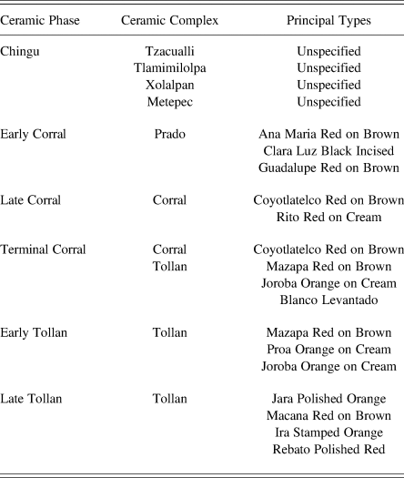
Locality B-1, some 100 meters south of the proposed right of way, was a large, rectangular mound, roughly 12 meters in width and 3 meters in height, that was bisected by the east-west brecha (figure 2) and further damaged when the brecha was widened to accommodate highway construction vehicles. The road cut revealed a complex construction history, containing multiple strata and loose ceramics that included Prado complex (Early Corral phase) sherds (Table 2). Although not part of the proposed right of way, it was targeted for limited excavation because of its apparent early date.
Ceramic phases, corresponding ceramic complexes, and principal types in the Tula ceramic chronology (Cobean Reference Cobean1990).

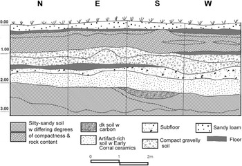
A 2 × 2 m pit placed in an undisturbed portion of the mound confirmed the complex construction history (Figure 3) suggested by the exposure in the road cut. The mound was a pyramid constructed in multiple stages with various layers of fill and intervening floors of compact soil and gravel consisting of crushed tepetate. Of particular interest is a layer of artifact-rich fill, nearly 1 meter thick, containing animal bone and Prado complex ceramics that confirmed its Early Corral phase date.
Profile of pit excavated into the Epiclassic Pyramid. Drawing prepared by Dan M. Healan.

While only the fill layers of the mound interior were encountered in excavation, a portion of the surrounding wall system was exposed in one of the road cuts, revealing a system of retaining walls constructed of large rounded boulders, possibly river cobbles. It is noteworthy that all of the materials used in the construction of the Epiclassic Pyramid could be obtained in the immediate area, including boulders, cobbles, and sand from the river and gravel from exposure of tepetate. One of the exploratory excavations encountered a tepetate outcrop with signs of quarrying activity.
Although the pyramid was initially constructed during the Early Corral phase, ceramics recovered from fill in higher levels include diagnostic Late Corral and Terminal Corral phase ceramics indicative of periodic expansion, prior to its apparent abandonment before the beginning of the Tollan phase. Fragments of human and animal bone, some of which had been burned, were also recovered from the fill, which might indicate ritual activity during construction.
Along with other evidence presented below, the Epiclassic Pyramid confirms the existence of Early Corral phase occupation in this area, presumably part of the settlement associated with the Tula Chico monumental complex c. 1 km to the southeast (Figure 1). It is smaller in size than the principal pyramid at Tula Chico, the latter measuring roughly 25 × 18 m, and with its supporting platform approaches six meters in height, suggesting the Epiclassic Pyramid was a local (barrio level) temple that served the immediate area.
Locality P6-1, Twin Temple Pyramid and Peripheral Structures
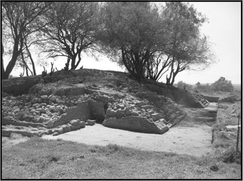
One of the most significant finds of the Proyecto ZUN is a highly distinctive Tollan phase structure that, in its final stage, consisted of a single pyramid with twin flanking stairways that apparently supported two separate temples (Figures 4–6). It is the only example of a twin temple pyramid discovered so far in Tula and would appear to be the oldest known example in western Mesoamerica. The pyramid lay directly in the path of the proposed highway, but given its obvious importance and cultural significance, the right of way was diverted, so that the structure remains intact today.
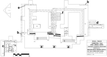
Plan of locality P6-1, the Twin Temple Pyramid and adjacent structures: (a) altars; (b) surrounding wall; (c and d) residential structures; (e) Palacio phase offering; (f) probable looter's pit. Plan drawing by the author.

West side of Twin Temple Pyramid, showing juxtaposed, but separate stairways. Photograph by the author.

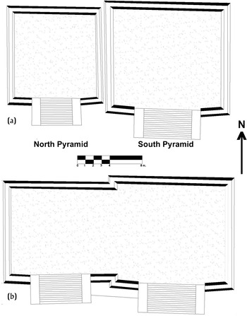
(a) Stage 3 of Twin Temple Pyramid, showing narrow space between North and South Pyramids, with possible astronomical significance; (b) stage 4, showing unification of North and South Pyramids. Plan drawing by the author.

Exploratory excavation of the pyramid revealed a four-stage construction history initially involving two separate pyramids, designated the North Pyramid and the South Pyramid. Stage 1 involved the construction of the North Pyramid, a low earthen platform whose overall size and form could not be determined, although itappears to have been relatively small (< 10 m wide) and rectangular, supporting a structure with adobe walls. Associated ceramics included Mazapa and Corral complex pottery consistent with a Terminal Corral phase date (Tables 1 and 2), although only ceramics from the upper portion of the platform were recovered; hence an earlier date for its initial construction is possible.
During stage 2, construction was likewise limited to the North Platform, during which it underwent enlargement plus the addition of a masonry facade and a staircase on the west side. The stage 2 north Pyramid was a two-tiered structure about 5 meters in height, which exhibited many of the characteristics of later monumental buildings at Tula, including the use of rectangular stone tablets to form a talud/tablero facade, and the use of tabular stone facing covered with stucco. Wall remnants presumed to be part of a surmounting temple were encountered on top. Associated ceramics likewise indicate a Terminal Corral phase construction date.
Stage 3, dated by ceramics to the Early Tollan phase, involved the expansion of the North Pyramid and the initial construction of the adjacent South Pyramid, whose size exceeded that of the North Pyramid (Figure 6a). The two were situated side by side, but separated by a narrow space. Unlike the North Pyramid, whose core was made of compacted soil, the South Pyramid exhibited an interior core constructed of cajones, a grid of intersecting walls whose interstices were filled with rounded boulders, presumably from the river. Cajones were also used in platform construction at Tula Grande, where its earliest occurrence appears to date to the Terminal Corral or Early Tollan phase (Healan et al. Reference Healan, Cobean and Bowsher2021). No walls associated with superstructures were encountered, although the South pyramid contained a remnant stucco floor with a slight (c. 3 cm) indentation similar to the shallow impluvia or “sunken patios” seen in Edificios 1, 3, and 4 at Tula Grande.
As seen in Figure 6a, the stage 3 pyramids differ in size, and slightly in spatial orientation. Their east–west orientation and the narrow space separating them afforded a view of the rising and setting sun, hence it may have had astronomical significance, a possibility that will be investigated in the future.
During stage 4, which occurred during the Late Tollan phase, the space between the two platforms was enclosed, creating a single pyramid accessed by the two independent staircases (Figure 6b). A new facade covered both structures, eliminating the previous difference in orientation, while giving the unified structure a slightly more northerly orientation. The north stairway was enlarged, becoming essentially the same size as the south stairway. No superstructural traces were found, although the upper surface of the stage 4 structure was largely obliterated by erosion in the northern portion and a large looter's pit in the middle (Figure 4f), as well as heavily worn footpaths. There is, however, considerable indirect evidence of their existence in the form of various whole and fragmentary sculptural elements recovered from the rubble surrounding the pyramid. These include panels, cornices, lintels, and other worked stone objects commonly used as decorative trim on the roofs and facades of structures at Tula Grande. Of particular interest are two objects in the rubble: a fragment of an almena, or decorative trim with a tenon at one end, and a rectangular stone block with a narrow slot into which the tanged element was apparently inserted. Both of these objects also appear at Tula Grande, as part of the roof trim lining the open patios of Edificio 3, and along the top of the Coatepantli, or serpent wall, on the north side of Pyramid B. In both cases the almena had the form of an ehecacoxcatl, or cut shell motif resembling an uppercase G (Mastache et al. Reference Mastache, Cobean and Healan2002: Figure 5.34). The almena recovered from the rubble was too fragmentary to determine its form, although G-shaped almenas were encountered in the nearby residential compound described immediately below.
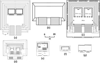
As noted above, the P6-1 pyramid would appear to be the earliest known example of the twin temple pyramid in western Mesoamerica, all other known examples of which are associated with the Late Postclassic Aztec (Figures 7a–7e), including the iconic Templo Mayor of Tenochtitlan. There are however, a number of pyramids with twin flanking stairways at Early Postclassic Zacaleu in highland Guatemala (e.g., Figure 7f), although each of these apparently supported a single rather than two separate temples. That the Tula example involved the union of two existing structures with different construction histories, as easily seen in the overall configuration of both its plan and its stairways, distinguishes it from the others.
Mesoamerican Twin Temple Pyramids: (a) Templo Mayor (after Serrato-Combe Reference Serrato-Combe2001: 10); (b) Tlatelolco (drawn from Google Earth imagery by Dan M. Healan); (c), Tenayuca (Marquina Reference Marquina1964:Lamina 51); (d) Teopanzalco (Marquina Reference Marquina1964:Lamina 63); (e) Santa Cecilia Acatitlán (García Moll and Fierro Padilla Reference García Moll and Padillo2016:Figure 7); (f) Zacaleu (Woodbury and Trik Reference Woodbury and Trik1953:Figure 32); (g) Tula.

Exploratory excavation in the surrounding area encountered three small altars in front of the pyramid (Figure 4a) and a wall apparently enclosing the pyramid and altars (Figure 4b) and separating them from adjacent residential structures (Figures 4c and 4d). Excavation immediately to the north and south encountered portions of two structural complexes, both badly damaged but appearing to have been residential compounds. Associated ceramics are Tollan Complex, hence the structures were probably contemporaneous with stages 3 and/or 4 of the pyramid. Extant remains include several hallmarks of Tula's elite architecture, including stucco flooring and tabilar stone facing on interior walls and a narrow gallery or portico along the building front. Several loose pieces of sculpture were recovered from the buildings, including stone panels and G-shaped almenas like those atop the coatepantli at Tula Grande.
There is substantial evidence of Aztec occupation during the Palacio phase. Aztec III ceramics were encountered in the rubble of both Structures c and d to the north and south of the pyramid. Structure d was heavily disturbed by excavation of a pit, perhaps in recent times, in whose profile were the remains of a stone-lined hearth, or tlecuil, that appears to have been part of a Palacio phase structure erected over the remains of Structure d.
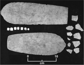
The most notable feature of the Palacio phase occupation was an offering associated with Aztec III ceramics located in the northeast corner of the walled area surrounding the temple (Figure 4e). The offering includes two chert “knives” or bifaces (Figure 7) that apparently were decorated to represent stylized faces in profile, although only loose shell pieces, including those representing teeth, were recovered. Very similar anthropomorphic bifaces have been recovered from offerings in the excavations of the Templo Mayor of Tenochtitlan (Matos Reference Matos Moctezuma1988:Plates XXI–XXIII). Aztec offerings including chert bifaces were found in various structures at Tula Grande, although none included anthropomorphic features.
Locality P6-2, Possible Administrative Building/Elite Residence
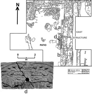
Excavation along the eastern edge of the same parcel, 80 m east of the Twin Temple Pyramid, uncovered portions of a large patio with adjacent structures atop platforms along the north and east sides (Figure 9), associated with Tollan complex ceramics. The exposed portion of the patio measured approximately 10 meters on one side with tabular stone facing on the north and east sides. The structure on the east side was accessed from the patio by twin abutting staircases faced with worked stone (Figures 9a and 9b). The structure was not preserved, but loose fragments of stone panels and other architectural ornaments recovered in excavation indicate that it was a structure of high architectural quality.
Palacio phase (Aztec III) offering consisting of two chert bifaces and shell pieces derived from anthropomorphic representations. Photograph by the author.

Plan of Locality P6-2, possible Administrative Structure/Elite Residence: (a and b) patio steps; (c) alfarda separating steps (a) and (b); (d) carved panel. Plan drawing and photograph by the author.

A large rectangular panel with a relief carving (Figures 9d and 10d) was encountered lying face down on the patio floor directly in front of, and aligned with, the central alfarda, or border between the two staircases, suggesting it had fallen forward from a position on the front of the alfarda. The panel was made of pink cantera, an easily worked volcanic stone of local origin commonly used at Tula Grande and elsewhere in the ancient city for relief carvings and other decorative sculpture, and measured c. 79 cm long, 40 cm wide, and 7 cm thick. The panel was broken into seven pieces, all present and in situ. The recessed portion of the relief carving was painted with red pigment, while the raised portion was painted with red, yellow, white, and light blue pigments.
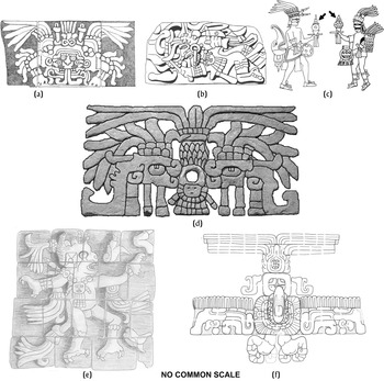
Comparison of carved panel from Locality P6-2 (d) with other representations from Tula and elsewhere: (a) h–j–p–s panel, Pyramid B, Tula Grande (Jiménez Garcia Reference Jiménez García2021:Figure 3a; (b) Reclining figure, Edificio 3, Tula Grande (Jiménez García Reference Jiménez García1998); (c) deities or deity impersonators holding tlacheloni's (arrows) (Vesque Reference Vesque2016:Figure 5; Olivier Reference Olivier2004:Plate 5b); (e) “dancing jaguar” frieze Los Falos, Chichén Itzá (Schmidt Reference Schmidt2003:Figure 33); (f) reconstruction of Scarlet Macaw frieze from Ball Court, Copan (Fash Reference Fash2010:Figure 3).

As seen in Figure 10d, the imagery on the panel is a bilaterally symmetrical arrangement of three groups of elements or motifs consisting of a central group flanked by two opposing groups that are imperfect mirror images of each other. The central group is a vertical arrangement of elements above and below a roughly circular element with a c. 5.5 cm wide orifice whose interior was painted white, with patches of stucco on its rim.
Immediately beneath the perforated circle is what appears at first glance to be an individual wearing a bead or mosaic collar, but is instead a necklace or breastplate of which the human face is part. A very similar necklace/breastplate is worn by a reclining individual on one of the carved panels from Edificio 3 at Tula Grande (Figure 10b). The face and surrounding collar of rectangular elements were painted yellow, and the two rows of rectangular elements immediately below were painted blue. Two elongated elements with yellow painted button–like terminal appendages extend diagonally from the collar, possibly elongated ear ornaments.
Immediately above the perforated circle is a representation of a bundle or multiple rows of feathers painted blue, topped with a red painted band beneath a row of blue painted rectangular elements, from which emerges a panache containing a single central plume painted white, flanked by two elongated blue painted plumes on each side. The latter are strikingly similar in appearance to representations of plumes in other sculpture at Tula, most notably what Jiménez García (Reference Jiménez García2021) calls the hombre–jaguar–pájaro–serpiente (h–j–p–s) figure that appears on the facade of Pyramid B at Tula Grande and numerous other localities within the ancient city (e.g., Gamboa Cabezas and Healan Reference Gamboa Cabezas and Healan2021).
The two flanking groups each contain a prominent eye bordered on its top and sides by stylized volutes and smaller spiral elements. Each eye contains a small divided rectangular element, perhaps to indicate a pupil or a shiny or wet appearance. Directly beneath each eye are two blue painted linear elements resembling drops of water presumed to represent tears. The volutes around each eye are painted blue, except for the three yellow painted spiral elements, two on the side facing the central group of elements and the other on the opposite side. Beneath the latter spiral is a linear arrangement of two or three rectangular elements that resemble the elongated ear ornaments often seen in representations of individuals at Tula, including Figure 10b. The blue volute over each eye is topped with two rows of rectangular elements, the lower also painted blue and the upper yellow, from which emerges a panache of red painted plumes that intertwine with those in the central element group. The two opposing groups are imperfect mirror images, exhibiting differences in the shape of volutes, number of plumes, and configuration of spiral elements.
While a more detailed analysis of the panel is currently in progress, a number of preliminary observations can be made, including that it is almost certainly of local manufacture given the use of local raw material and the iconographic and stylistic parallels to other representations at Tula noted above. The central group of vertically arranged elements and prominent circular orifice collectively resemble a tlachieloni (Figure 10c), or “optical apparatus” (Olivier Reference Olivier2004:206), as depicted and described in numerous contact period codices, and which the latter author associates principally with the Aztec deity Tezcatlipoca. According to the imagery and descriptions these sources provide, the central orifice gives the object its name, which informants of Sahagún describe as “a hole through which he watches people” (Sahagún Reference Sahagun1997:95). Olivier believes that the object, which he describes as a scepter, is so closely associated with Tezcatlipoca that it can be used as to identify the deity (Olivier Reference Olivier2004:60).
The two opposing groups of elements appear to represent highly stylized masks viewed in profile, each facing the tlachieloni. Only the eye of the wearer is visible, suggesting the individual or deity represented is largely invisible, and the spiral elements could represent smoke, a possible reference to Tezcatlipoca. The differences noted between the two masks may be intentional, representing twin deities or a distorted reflection of a single deity.
It must also be noted that some of the elements seen in the Tula carved panel have counterparts in the art and ideology of other parts of Mesoamerica, most notably the Maya region. The yellow spirals in front of the eyes are reminiscent of similar elements in representations of the Maya god Cauac recognized as the witz monster that, as described by Schele and Freidel (Reference Schele and Friedel1990:427) citing a personal communication from David Stuart, were found in the corners of temples that served as access caves to the underworld, located atop pyramids that represented the sacred mountain or witz. Representations of necklaces or breastplates containing a human face have been identified in stelae at several Late Classic Maya sites including Machaquilá del Petén, Bonampak, and Yaxchilan (Grube Reference Grube and Nikolai2000) which, according to the latter author, were worn by nobility during ceremonies of autosacrifice. Of particular interest is a sculpted frieze (Figure 10e) on the building known as Los Falos in the Initial Series Group at Chichen Itzá (Schmidt Reference Schmidt2003:Figure 29), depicting what appears to be a feline impersonator with a remarkably similar necklace, including the diagonal elements thought to be ear ornaments.
Karl Taube (personal communication, 2015) has noted that the imagery on the Tula panel exhibits notable similarities to the composite reconstruction (Figure 10f) of a series of eight friezes depicting a Scarlet Macaw in flight that apparently adorned the facades of Buildings 9 and 10 of the Ball Court at Late Classic Copan, Honduras (Fash Reference Fash2010:Figures 2 and 3). Particularly notable are the similarities between the panache at the top of the central group of elements on the Tula panel and the tail of the Copan Macaw, and the necklace of rectangular elements and face or faces on both. As seen in Figure 10f, the head of the Copan Macaw is a projecting appendage, raising the possibility that the orifice in the Tula panel likewise held a tenoned projecting head, although no such object was encountered in excavation. The lack of a head and the absence of feet and clear representations of wings make the identification of the imagery on the Tula as a macaw or other avian representation problematic, but there is both direct and indirect evidence of macaws from Epiclassic period contexts at Tula. These include a human burial containing the partial remains of two macaws (Ara militaris) (Paredes Gudiño and Healan Reference Paredes Gudiño and Healan2021) in the Museo locality, and a relief carving of a probable macaw associated with the ruins of a temple or pyramid at Tula Chico (Cobean et al. Reference Cobean, Healan and Suárez2021:Figure 5g). The possibility that the Tula panel incorporates and perhaps reinterprets iconographic elements and ideological concepts from other areas of Mesoamerica, perhaps including pan–Mesoamerican concepts, will be considered in a subsequent study.
The northwest corner of the patio contained a large concentration of broken pottery (Figure 9e) that included the basal portion of 20 Soltura Red-Orange and other large ollas, all resting undisturbed on the patio floor. In addition to these in situ partial specimens, the quantity of loose olla sherds in the deposit indicate the total number of ollas present was much larger, estimated at between 40 and 45 vessels. The concentration also included the remains of perhaps 10 bowls of Jara Polished Orange and Macana Red on Brown. The soil in the basal portions of the ollas contained numerous macroscopic plant remains that included beans and maize. The storage of large quantities of food and perhaps non-food items in the patio of a large, well-built structural complex may indicate the control and possible redistribution of agricultural products at the local level, suggesting the complex may have functioned in an administrative capacity. Alternatively, the mass storage of food may have been in preparation for feasting, which would suggest the structure was the residence of locally powerful elites, although the fact that this store of food apparently went unused is perplexing. While the pattern of breakage suggests plow damage, this portion of the courtyard appears to have been spared from the ravages of modern agriculture given its depth and its location along the edge of the parcel, raising the possibility the vessels were broken prior to entering the archaeological state.
It is unfortunate that so little remained of this crucial structural complex. An irrigation canal along the edge of the adjacent parcel 7 precluded excavating further to the east, and to the west the structure had been largely destroyed by mechanized plowing. The proximity of this complex to the Twin Temple Pyramid suggests that they were religious and administrative components of the same barrio. If so, the intervening area may likewise have housed major components of the barrio's administrative, religious, and sociopolitical infrastructure, although most are probably severely damaged or destroyed. In the adjacent parcel 7, survey encountered a mound over 2 m in height in the southeast corner that may likewise have been a barrio-level temple, which unfortunately was destroyed by the landowner during the several months that passed between survey and excavation.
As in the P6-1 locality, there is evidence of a Palacio phase occupation, including a compacted earth surface associated with Aztec III ceramics overlying the structure on the east side of the patio, although little remained. An intrusive burial containing an Aztec III censer was found near the southern limits of the excavation.
Locality P7-1, Terminal Corral Phase Habitation Area
In the southern portion of the adjacent parcel 7, surface ceramics suggested the presence of an earlier (Terminal Corral phase) occupation that prompted exploratory excavation in what was designated Locality P7-1. Beneath the plow zone, excavation uncovered a surface marked with erosional rills from water runoff that originated from an area containing ash and evidence of exposure to fire, and impressions that appeared to be the imprint of vessel bottoms. This suggested some activity involving the heating of water or other liquid, and perhaps its intentional disposal
Excavation beneath this feature encountered three partial burials. The first was missing the bones of one leg, the second lacked the skull, and the third contained only a skull and cervical vertebrae, possibly belonging to the individual in the second burial. Near these were two burials of young canids, species undetermined (Alicia Blanco Padilla, personal communication 2006). Similar canid burials, including those of the west Mexican species Xoloizcuintli, were encountered in Early/Late Corral phase contexts in excavations in other localities in Tula (Cobean et al. Reference Cobean, Healan and Suárez2021; Paredes Gudiño and Healan Reference Paredes Gudiño and Healan2021), but the burials in parcel 7-1 appear to date to the subsequent Terminal Corral phase.
Locality P1-1, High-Status Apartment Compound
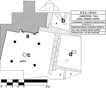
At the south end of parcel 1, the widening of the brecha truncated the south end of a large rectangular platform, exposing structural remains. Extensive excavations were conducted on the northern portion of the platform some 15 m from the brecha, exposing an area of approximately 140 square meters that included an interior patio and adjacent rooms of what appears to be a large residential structure (Figure 11) whose layout and architectural quality suggests it was an elite residence, as also suggested by its location on a natural elevation overlooking the Tula River. Associated ceramics date the structure to the Early/Late Tollan phases.
Plan of Locality P1-1, High Status Apartment Compound: (a) patio steps; (b) anomalous adobe partitions; (c and d) tlecuiles. Hatched area indicates structures too badly damaged to discern. Drawing by Alfredo Reyes Castro.

Only the patio and adjacent rooms on the east and northeast sides of the patio were intact (Figure 11:1–4), while those on the west and northwest sides were completely destroyed. Three sides of the patio were exposed, which if square, would measure approximately 8.5 meters on one side. Its floor and those of the intact rooms were covered with stucco, and at its center were the remains of four round columns surrounding a large subfloor tlecuil (Figure 11c). Only the bases of the columns remained, but one contained the remains of a wooden beam. Associated debris indicated the columns had been faced with tabular stone covered with stucco—the same mode of construction used in the columns and pillars of Edificios 3 and 4, Tula Grande. The columned area may have been open to the sky, a common feature of hypostyle buildings at Tula. The patio was accessed by a set of stairs at the north end (Figure 11a), a well-built feature faced with worked stone slabs and blocks, with flanking alfardas faced with worked stone.
All walls were constructed of adobe covered with stucco, except for an anomalous partition in room 4 that subdivided it into two or more irregular areas (Figures 11b and 11c). Room 1was a spacious room, which, if square, would measure approximately 5.5 meters on one side and contained a tlecuil at its center Figure 11d). The room floor contained numerous fragments of Soltura Red-Orange ollas, though not in the quantity seen in the patio of the “Administrative Structure” in P6-2. No access between this room and the patio was apparent, although some doorways in other residential structures at Tula had “step-over” thresholds. Room 1 may also have been accessed from Room 3 or another room to the east.
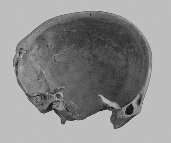
Room 3, in the southeast corner of the excavation, contained fragments of human bone, with evidence of beveling and polishing and traces of paint. The most intact specimen is the right half of a calvarium that had been made into a container (Figure 12). The interior surface was painted red, with a turquoise band on the rim. Room 3 and perhaps other parts of the compound housed activities associated with the manufacture of objects from human bone.
Container made from the right half of a human calvarium, with red painted interior and blue rim (no scale). Photograph by the author.

The Locality P1-1 structure is similar in layout and architectural quality to Edificio 4, Tula Grande, which Báez Urincho (Reference Báez Urincho2021) suggests was a palace. Similar buildings have also been found in other localities at Tula (Healan Reference Healan2012:66–67), suggesting that individuals of high status lived in barrios throughout the city. Their common layout involving rooms clustered around interior patios led Healan (Reference Healan2012) to refer to them as “apartment compounds,” although Gamboa Cabezas and Healan (Reference Gamboa Cabezas and Healan2021) prefer “room cluster compound,” a term that does not presume the structures necessarily housed more than one family.
Evidence that working human bone was an activity in this particular household is of particular interest in light of previous studies that identified specialized craft activity associated with the occupants of elite residences in other parts of Mesoamerica (Aoyama Reference Aoyama2007; Inomata Reference Inomata2001; Manzanilla Reference Manzanilla2006). Previous evidence from Tula includes possible cloth and tecalli vessel manufacture in areas adjacent to Tula Grande (Healan Reference Healan2012:70). More recently, similar evidence of activity involving the modification of human skulls was found in a similar structure likewise situated on a terrace along the Tula River immediately west of Tula Grande (Gamboa Cabezas and Healan Reference Gamboa Cabezas and Healan2021).
As with other localities in the area of investigation, excavation encountered evidence of Aztec occupation in the P1-1 locality which, in this case, involved covering the Tollan phase structure with a thick layer of fill that apparently supported a Palacio phase structure. Unfortunately, agricultural activity had removed all but the fill layer and associated Aztec III ceramics.
During excavation it was determined that recent agricultural activity had deposited soil from adjacent areas over the P1-1 platform, creating a reverse stratigraphy in which deposits containing Prado and Coyotlatelco complex ceramics overlay Palacio phase and Tollan phase strata. Although out of context, these secondary deposits provide additional evidence of Epiclassic period settlement in the ZUN.
Locality P12-1, House Compound
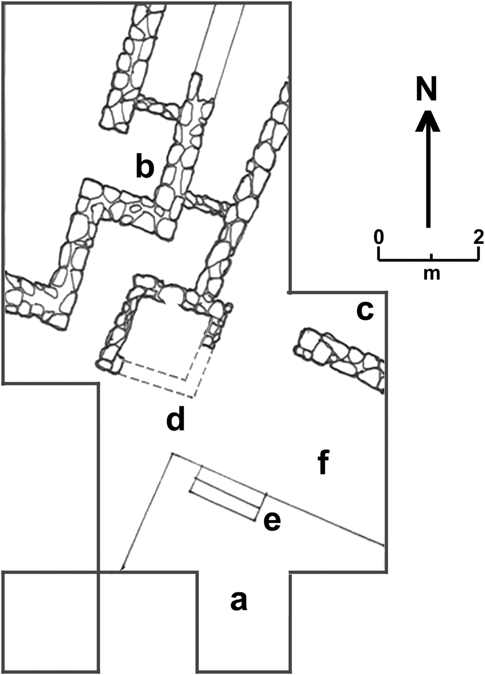
In parcel 12, near the eastern end of the area of investigation, excavation of a low platform encountered a portion of a house compound (Figure 13), probably the most common form of residential structure in the Tollan phase city (Healan Reference Healan, Manzanilla and Chapdelaine2009). Excavation exposed the northeast portion of an outdoor patio (Figure 13a) and two clusters of rooms (Figures 13b and 13c) pertaining to one or probably two distinct structures on its north and northeast flank. Like other house compounds, the patio was at ground level and flanked by platforms, atop which the individual houses were set back from the edge to form a corridor around the patio (Figure 13d), which was accessed by steps at least in the northwest corner (Figure 13e).
Plan of Locality P12-1, probable house compound: (a) patio; (b and c) adjacent structures; (d) surrounding passageway; (e) steps; (f) subfloor cache of pottery and figurine. Plan drawing by Dan M. Healan.

If the remains in Figure 11 are like other house compounds excavated at Tula, they comprise the northwest portion of a compound consisting of an exterior patio enclosed by individual houses on its four sides. Some house compounds contain additional houses in the open corners, which may be the case here (Figure 13b). The dimensions of the excavated portion suggest that the overall compound would have been of comparable size to the Central Group, a completely exposed house compound in the Canal locality, approximately 1.5 kilometers to the southeast (Healan Reference Healan2012:Figure 8g).
The P12-1 house compound was badly damaged, but sufficiently intact to indicate its walls were constructed of tepetate cobbles mortared with mud, a common type of wall construction for Tollan phase house compounds. Both the patio and room floors were compacted clay and sand, but traces of stucco were found in the corridor surrounding the patio. Exploratory excavation indicated that no previous structures had existed, and associated ceramics indicate a Late Tollan phase occupation.
As with other house groups, the ceramic assemblage includes sherds of predominately utilitarian ceramics, plus braziers and censers suggestive of ritual activity at the household level. As with many of the other residential structures excavated at Tula, associated ceramics also included exotic specimens, in this case, sherds of Tohil plumbate and an undetermined variety of Fine Orange. Exploratory excavation of the North Platform encountered a cache of ceramic objects (Figure 13f) that included three miniature vessels, a human figurine depicting an elderly individual, possibly the deity the Aztecs called Huehueteotl, and a fragment of a flute painted in multiple colors. Its location inside the platform and lack of association with a burial suggests it was a dedicatory offering from when the house compound was constructed.
If the admittedly limited exposure is representative, it appears that this locality was not settled until late in Tula's history, perhaps during the final episodes of its expansion. Given the thin soil, numerous tepetate outcrops, and little surface evidence of occupation in the larger area, as noted above, it may have been considered undesirable for settlement until late in Tula's history. The lack of evidence of continuous settlement between P12-1 and the other excavated localities suggests it may have lain beyond Tula's urban limits.
The presence of Aztec III pottery sherds and figurine fragments indicate the locality was occupied during the Palacio phase, although no intact structural or other remains were identified. Also present were a small number of Fuego phase (Aztec II) ceramics, one of the few indications of possible Fuego phase occupation outside of Tula Grande.
SUMMARY AND DISCUSSION
The proposed construction of the Arco Norte provided an opportunity to systematically investigate a segment of the ancient city that was previously unknown. Taking advantage of the inherently linear nature of highway projects, the investigation took the form of a 1.4-km transect across the northern part of the ancient city (Figures 1 and 2).
A comparison of the results of the pedestrian survey with Yadeun's (Reference Yadeun and Moctezuma1974) previous survey and mapping shows that many of the mounds present in 1974 have been destroyed, mostly from intensive mechanized agriculture that included intentional razing of mounds as much as 2 meters in height. Fortunately, a number remained intact, including the Twin Temple Pyramid, whose importance was such that it was successfully saved from destruction by rerouting a portion of the proposed highway.
Additional evidence of the considerable damage to prehispanic remains in the area became evident during exploratory excavation, but this also revealed that limitations in the maneuverability of large agricultural machinery tended to leave archaeological remains intact along the margins and in the corners of agricultural fields, a discovery that played a major role in deciding specific locations for conducting more extensive excavations.
The Proyecto ZUN investigations provided extensive evidence of settlement that began very early in the city's history and persisted throughout its life and beyond. This includes evidence of Prado complex (Early Corral phase) occupation in Localities B-1 and P1-1 that suggest this area was part of the early settlement centered around Tula Chico, located nearly 1 kilometer to the south. This possibility was previously suggested by Yadeun (Reference Yadeun1975:Figure 30) on the basis of sparse Coyotlatelco surface ceramics, but until now had not been confirmed by excavation—hence Epiclassic Tula appears to have been larger than previously thought. The presence of Prado ceramics likewise refutes the previous notion that this ceramic complex was restricted to elites who lived around Tula Chico.
The succeeding Terminal Corral phase is a transitional period whose ceramic assemblage includes representatives of both the preceding Corral and the subsequent Tollan complexes (Table 2). Its transitional character, which makes it susceptible to confusion with mixed deposits, plus the fact that it was initially defined on the basis of data from only two excavations (Cobean Reference Cobean1990:46–48) has raised questions about its validity (Healan Reference Healan2012:83). However, the presence of Terminal Corral phase ceramic assemblages in several localities in the ZUN not only provides support for its validity, but suggests it can be refined or even subdivided. On the one hand, two particularly diagnostic Terminal Corral types, Mazapa and Blanco Levantado ceramics, were found to co–occur with diagnostic Coyotlatelco ceramics of the preceding Late Corral phase in the earliest stage of the North Platform of the Locality P6-1 Twin Temple Pyramid, while in Locality P7–1, Mazapa ceramics co–occurred with those of the subsequent Tollan complex ceramics, thus suggesting that these two contexts date from early and late portions, respectively, of the Terminal Corral phase.
With the exception of the Epiclassic Pyramid, Tollan ceramics were the predominant ceramic complex in all of the localities excavated, confirming evidence from surface survey that this area was as much a part of the Early Postclassic city as areas closer to the urban core.
In addition to its invaluable role in locating intact remains for subsequent investigation, exploratory excavation also identified a diversity of structures and associated remains like those found in other large-scale investigations in other parts of the city (e.g., Gamboa Cabezas and Healan Reference Gamboa Cabezas and Healan2021). Such diversity at the local level suggests the existence of formal neighborhoods or barrios, each with its own political, religious, social, and other institutions that mimic those of the larger urban polity. Thus the exploratory excavations provided an opportunity to sample various types of structures and associated institutions that collectively comprise the components of a functioning barrio, including the domestic, religious, social, and political realms. It is not known whether all of the localities sampled in excavation were part of a single barrio, but their remains are assumed to collectively represent the variety of institutions present.
While structures believed to have been barrio-level temples have been found in other excavations at Tula (Paredes Gudiño and Healan Reference Paredes Gudiño and Healan2021; Stocker and Healan Reference Stocker, Healan and Healan1989), the Twin Temple Pyramid in Locality P6-1 is unique in its size and configuration of dual temples and stairways. While in some ways it presages the Templo Mayor and other Aztec examples, it is worth noting that it originated as a single pyramid during the Late Corral or Terminal Corral phase, before additional construction produced an adjacent but separate pyramid that remained a separate structure until the two were joined during the Late Tollan phase, and even then maintained spatially separated stairways. Its unique size and form may reflect the importance of this particular barrio with respect to the deities involved. It appears to have been regarded as a special structure by the later Aztec occupants, whose offering of anthropomorphic chert bifaces, a common component of offerings in Tenochtitlan's Templo Mayor, is the only one of its kind from Tula.
Evidence of political institutions at the barrio level includes the possible administrative structure in Locality P6-2, which appears to have been involved in the mass acquisition of foodstuffs, suggesting its occupants exercised control over their distribution. Although I have called it an Administrative Structure, it may also have had a residential component beyond the extremely limited exposure, presumably housing those who held political power in the barrio, raising the alternative possibility that the massed foodstuffs were in preparation for a feast. Either interpretation would point to the structure and its inhabitants as a barrio-level political institution. The carved panel possibly containing references to Tezcatlipoca and/or Maya themes and concepts likewise suggests activities beyond the purely domestic realm, although the panel may have been acquired elsewhere in the city given prior evidence of reuse of sculpture in constructing tlecuiles (Gamboa Cabezas and Healan Reference Gamboa Cabezas and Healan2021:Figure 4a) and as decorative facing on an alfarda in another patio (Healan Reference Healan and Dan M.1989:Figure 9.18).
Locality P1-1 provides an additional example of a probable elite residence, in this case one located on a terrace overlooking the Tula River whose rather distant location from Locality P6-2 raises the possibility that the two were not part of the same barrio. Given its seeming high status, the presence of household activity involving the manufacture of painted containers and probably other objects from human bone may seem surprising, but consistent with evidence of elite households that engaged in craft manufacture in other parts of Mesoamerica.
Locality P12-1 offers a glimpse of barrio-level residential life at the commoner end of the social spectrum, although this locality may not have been part of the barrio or barrios with which the other localities were affiliated. Despite the limited exposure, its less than spacious character and lack of architectural elaboration is in sharp contrast to the elite residence in Locality P1-1, and possibly P6-2, yet it appears that the residents of the P12-1 House Compound enjoyed access to exotic goods, a phenomenon that has been observed repeatedly in excavation of other non-elite residences at Tula (Diehl et al. Reference Diehl, Lomas and Wynn1974; Gamboa Cabezas and Healan Reference Gamboa Cabezas and Healan2021; Paredes Gudiño and Healan Reference Paredes Gudiño and Healan2021).
Finally, although modern agricultural practices in this area have inflicted the worst damage upon these uppermost remains, the Aztec occupation of the area appears to exhibit many of the same characteristics seen in other parts of Tula. This includes a tendency to reoccupy existing Tollan phase structures with apparently little or no modification. A notable exception appears to be Locality P-1, where the Tollan phase Apartment Compound was covered by fill that presumably supported a structure that has since been destroyed. Its favorable location on a terrace overlooking the Tula River may explain the special attention paid to occupation in this locality.
In retrospect, the Proyecto ZUN brings three particularly notable revelations to the study of ancient Tula. First, the remains encountered in excavation indicate comparable political, social, religious, and economic institutions to those inferred from excavations conducted in other parts of the city, which not only supports previous interpretations of Tula's internal organization along barrio lines, but suggests that this organization was as codified in barrios in the northern fringes of the city as it was in those at its core. Second, these rich, diverse remains were recovered from excavations whose location was determined not by prior archaeological information, but by factors wholly unrelated to archaeology, in a sense wholly random with respect to prior archaeological knowledge, which speaks volumes about the potential richness, diversity, and complexity of the site as a whole. Third, despite the considerable destruction that Tula has sustained in recent decades, portions of the prehispanic city remain amenable to systematic investigation using methods adapted to the constantly changing landscape of modernization and development.
RESUMEN
La construcción propuesta de una autopista que cruzaría la parte norte del sitio de Tula—es decir, las ruinas de Tollan-Xicocotitlan—condujo a la creación del “Proyecto de Salvamento Arqueológico en la Carretera de Libramiento Norte de la Ciudad de México,” en lo que se denominó la Zona Urbana Norte (ZUN). Se creó así un programa de prospección, excavaciones de salvamiento, y rescates diseñados para evaluar, registrar, y en algunos casos proteger el patrimonio arqueológico a lo largo de la ruta propuesta. El área de investigaciones forma una banda estrecha, aproximadamente 2 km de longitud, dentro de tierras agrícolas subdivididas en parcelas cuadrangulares. El área considerada como ZUN es parte de la zona urbana de Tula que fue recorrida y mapeada por Yadeun (Reference Yadeun and Moctezuma1974), quien identificó numerosos montículos y terrazas habitacionales en el área. Por desgracia, un número sustancial de las estructuras prehispánicas se han destruido mediante el arado mecanizado y la nivelación de la tierra. Otros 11 montículos que yacían dentro del derecho de vía de la carretera también estaban programados para su destrucción, incluida una pirámide con templos gemelos muy importante, que se conservó al lograr el desvío de la carretera.
El trabajo de campo para el Proyecto ZUN se realizó en 2004 y 2005, y contó con un programa arqueológico de múltiples fases para localizar, evaluar, e investigar restos prehispánicos en el área de investigación. La fase 1 fue un recorrido durante lo cual se realizó una evaluación preliminar de las características arqueológicas y su aparente estado de conservación, así como la identificación de evidencia topográfica de estructuras probables para investigación potencial. Después del recorrido, se realizaron 30 excavaciones exploratorias en lugares seleccionados por las características topográficas o el material de la superficie. Estas excavaciones indicaron que la ocupación prehispánica abarcó toda la secuencia de ocupación (la fase Corral temprana hasta la fase Tesoro) e incluyó una variedad de estructuras y otros restos que llevaron a excavaciones más intensas en cinco localidades.
La Localidad B-1, la “Pirámide Antigua,” fue un montículo dañado por la construcción de la carretera, donde la excavación reveló que se construyó durante la fase Corral temprano, lo que proporciona evidencia de que la localidad fue parte del primer asentamiento de Tula (período epiclásico).
La localidad P6-1 contiene una gran pirámide con dos escaleras y templos gemelos, el ejemplo más antiguo de tal estructura en el oeste de Mesoamérica durante la fase Corral terminal. La excavación reveló que se originó como dos plataformas separadas que posteriormente se unieron durante la fase Tollan. Posteriormente, en la fase Palacio, se colocó una ofrenda cerca del edificio que contuvo dos bifaciales (“cuchillos”) antropomórficos de sílex.
La localidad P1-1 contenía un complejo de departamentos situado en una terraza frente al río Tula que claramente era una residencia de élite que había sido gravemente dañada por el arado y la construcción de la carretera. Uno de los cuartos intactos contenía numerosos fragmentos de hueso humano trabajado y pintado, incluido un recipiente pintado hecho de un cráneo humano.
La localidad P12-1, ubicada cerca del extremo oriental del área de investigación, era un complejo de casas simple que fue la forma más común de vivienda en Tula, aunque sus habitantes disfrutaban de acceso a artículos exóticos al igual que los de otros complejos de casas en Tula.
El Proyecto ZUN proporcionó evidencia de que la organización y el estilo de vida característicos de los barrios en el núcleo urbano de Tula también eran característicos de aquellos en los límites norteños de la ciudad. Además, las investigaciones revelaron que a pesar del daño considerable sufrido por el sitio en los últimos años, porciones significativas de la antigua Tula aparentemente permanecen intactas y susceptibles de investigación arqueológica.
ACKNOWLEDGEMENTS
First of all, I appreciate the invitation from Dr. Dan M. Healan and Dr. Robert H. Cobean to participate in this special section, and the opportunity to publish the results of my research derived from an archaeological salvage and rescue project. I also extend my gratitude to the archaeologists Margarita Carballal Staedtler and Ma. Antonieta Moguel Cos of the DSA-INAH, for their trust and support in my directing the project involving the “Arco Norte” highway. I am especially grateful to Dr. Healan above all, for his interest and advice in bringing this work to its best conclusion, and his critical help and advice that reflect his having been my “maestro” for many years. Happily, I continue to learn from his teaching.