


1. Introduction
Constraining marine-terminating ice sheet and crustal behaviour during advance and retreat phases is important for understanding the behaviour of past ice sheets and ice contributions to global sea levels (Dietrich et al. Reference Dietrich, Ghienne, Schuster, Lajeunesse, Nutz, Deschamps, Roquin and Duringer2017). However, in most areas of Antarctica the precise patterns of retreat at the grounded ice margin are generally not well represented by exposed outcrops of glacial deposits. The impacts of advances and retreats of substantial ice masses are dominated by a combination of allogenic factors such as eustasy (including both sea level falls due to the withdrawal of seawater to form ice and sea level rises due to melting during deglacial periods), tectonism (causing uplift and subsidence), and isostasy (due to crustal depression and release caused by ice loading and unloading; Boulton, Reference Boulton1990; Fielding et al. Reference Fielding, Browne, Field, Florindo, Harwood, Krissek, Levy, Panter, Passchier and Pekar2011; Dietrich et al. Reference Dietrich, Ghienne, Lajeunesse, Normandeau, Deschamps and Razin2019). The rapidity of isostatic effects is also likely to be influenced by the thermal state of the underlying lithosphere (Fielding et al. Reference Fielding, Browne, Field, Florindo, Harwood, Krissek, Levy, Panter, Passchier and Pekar2011). However, autogenic controls, which refer to processes driven by internal dynamics, can also be important and have to be identified and, where possible, filtered out before allogenic factors can be considered. Autogenic processes can create landforms and patterns of sedimentation that are geographically highly localized and are a natural consequence of a system’s internal behaviour independent of external processes like climate or tectonics.
King George Island, the largest of the South Shetland Islands in northern Antarctic Peninsula, is host to deposits of at least three important glacial episodes involving ice masses in the Antarctic Peninsula region (Birkenmajer, Reference Birkenmajer1987 a, b; Smellie et al. Reference Smellie, Hunt, McIntosh and Esser2021 a b; Nawrocki et al. Reference Nawrocki, Pańczyk, Smellie, Kozłowska-Roman and Tomczyk2025). The largest and most significant episode is the Late Oligocene Polonez Glaciation, represented by the glacial and glaciomarine Polonez Cove Formation, which is correlated with the Oi2b isotope event (c. 26–27 Ma; Smellie et al. Reference Smellie, McIntosh, Whittle, Troedson and Hunt2021 b; Duncan et al. Reference Duncan, McKay, Levy, Naish, Prebble, Sangiorgi, Krishnan, Hoem, Clowes, Dunkley Jones, Gasson, Kraus, Kulhanek, Meyers, Moossen, Warren, Willmott, Ventura and Bendle2022; Nawrocki et al. Reference Nawrocki, Pańczyk, Smellie, Kozłowska-Roman and Tomczyk2025), a major global cooling episode (Miller et al. Reference Miller and Mountain1996). It is of particular importance as it was the first direct proof of Antarctic ice present at a low elevation prior to the Miocene (Birkenmajer, Reference Birkenmajer1982; Porębski and Gradziński, Reference Porębski and Gradziński1987). The Polonez Cove Formation is the only known deposit related to Oi2b, and it crops out at several widely separated localities along the south coast of King George Island. It is very well exposed, more or less continuously, for 2.6 km in cliffs between Low Head and Lions Rump, where the type area is defined (Birkenmajer, Reference Birkenmajer1982; Figures 1 and 2). The Polonez Cove Formation is the one of the best-known and most intensively studied Cenozoic geological units in Antarctica (e.g. Birkenmajer, Reference Birkenmajer1982, Reference Birkenmajer1987 a, b, Reference Birkenmajer1995; Birkenmajer and Weiser, Reference Birkenmajer and Weiser1985; Gaździcka and Gaździcki, Reference Gaździcka and Gaździcki1985; Birkenmajer and Gaździcki, Reference Birkenmajer and Gaździcki1986; Porębski and Gradziński, Reference Porębski and Gradziński1987, Reference Porębski and Gradziński1990; Dos Santos et al. Reference Dos Santos, Rocha-Campos, Trompette, Uhlein, Gipp and Simóes1990; Dingle et al. Reference Dingle, McArthur and Vroon1997; Dingle and Lavelle, Reference Dingle and Lavelle1998; Troedson and Smellie, Reference Troedson and Smellie2002; Quaglio et al. Reference Quaglio, Anelli, Dos Santos, De Perinotto and Rocha-Campos2008, Reference Quaglio, Warren, Anelli, Dos Santos, Rocha-Campos, Gazdzicki, Strikis, Ghilardi, Tiossi and Simoes2014; Smellie et al. Reference Smellie, McIntosh, Whittle, Troedson and Hunt2021 b; Nawrocki et al. Reference Nawrocki, Pańczyk, Wójcik and Tatur2021, Reference Nawrocki, Pańczyk, Smellie, Kozłowska-Roman and Tomczyk2025). As a result, the lithofacies and general depositional history are relatively well known, involving a progression from ice-contact and ice-proximal till of a marine-terminating ice sheet up into a variety of shallow-marine sediments. The variations in lithofacies were interpreted by Troedson and Smellie (Reference Troedson and Smellie2002) to be caused mainly by fluctuations in sediment supply linked to pulses of local volcanism. However, the nature of that volcanism and how it is connected to sedimentation in the Polonez Cove Formation, either acting passively simply as a provenance or as active volcanism situated within the sedimentary basin itself, have never been examined closely. The relative influence of allogenic and autogenic controls is thus unclear. The nature of the evolving Late Oligocene landscape, including the extent of contemporaneous ice and the influence of coeval volcanism on sedimentation, is also not well understood. The Polonez Cove Formation is overlain by a predominantly volcanic sequence known as the Boy Point Formation (BPF), which has been much less studied (Birkenmajer, Reference Birkenmajer1982; Smellie et al. Reference Smellie, McIntosh, Whittle, Troedson and Hunt2021 b). However, the BPF contains unique information about the post-Polonez Cove Formation evolution of the local landscape, its ice cover and associated base-level changes. Combining the knowledge derived from both successions enables a much more holistic understanding of the behaviour of Late Oligocene ice in the northern Antarctic Peninsula region not only during the recession from a major glacial (Oi2b) but also during a hitherto-unrecognized ice advance.
Location Map showing the location of King George Island in the South Shetland Islands (northern Antarctic Peninsula; inset), the distribution of the rocks described in this study (coloured red; other rock outcrops shown in grey) and localities mentioned in the text.

Figure 1. Long description
The map displays the geographic area of the South Shetland Islands, focusing on King George Island. Key locations labeled include Magda Nunatak, Lions Rump, Low Head, Vaureal Peak, Cape Melville, and Three Sisters Point. The map highlights the distribution of specific rock formations in red, with other rock outcrops shown in grey. An inset map in the bottom right corner shows the broader context of the South Shetland Islands in relation to the Antarctic Peninsula, specifically highlighting King George Island, Bransfield Strait, and Antarctic Peninsula. The main map includes a scale bar indicating distances in kilometers and a coordinate grid for precise location referencing.
Geological map of the Polonez Cove and Boy Point formations, including the locations and ages of isotopically dated lavas (by 40Ar/39Ar). Based on Smellie et al. (Reference Smellie, McIntosh, Whittle, Troedson and Hunt2021 b), modified.

This paper is a comprehensive re-evaluation of the Polonez Cove and Boy Point formations on King George Island. It presents new detailed geological maps, stratigraphical, sedimentological and volcanological field observations, and new palaeoenvironmental information. A particular focus is on the volcanic units within both formations and their unique impact on the associated sedimentary deposits. They are used to document the relative influence of autogenic versus allogenic controls on sedimentation and examine the pattern of evolution of the Late Oligocene landscape and ice configuration. The study is based primarily on unpublished results from fieldwork on the Polonez Cove Formation by the author, expanded to include the first detailed study of the BPF. A revised and improved stratigraphy of both formations is provided. Sedimentological–volcanological controls were overwhelmingly autogenic. However, a tectonic influence on baseline elevation is also recognized, and other allogenic influences (glacio-isostasy and eustasy) are identified and described for the first time. The study has also enabled the Oi2b ice sheet to be reconstructed across Antarctica.
2. Geological background
The geology of King George Island is dominated by Palaeocene and Eocene volcanic sequences erupted under subaerial conditions (Smellie, Reference Smellie and Kleinschmidt2021 a). They are the products of several large overlapping mafic–intermediate stratovolcanoes linked to subduction at the South Shetland trench (Leat and Riley, Reference Leat and Riley2021 a, b). The island is also host to distinctive sedimentary deposits formed during at least three important Late Oligocene and younger glacial episodes: the Polonez Glaciation (Oi2b; c. 26–27 Ma), Melville Glaciation (Mi1a; c. 21–22 ma) and Legru Glaciation (poorly dated but possibly ≤c. 10 Ma; Smellie et al. Reference Smellie, Hunt, McIntosh and Esser2021 a, b; Nawrocki et al. Reference Nawrocki, Pańczyk, Smellie, Kozłowska-Roman and Tomczyk2025). The two oldest sequences are marine, whereas the third (Legru Glaciation) is a terrestrial alpine event and comprises deposits transported and released from an ice cap situated on King George Island (Birkenmajer, Reference Birkenmajer1987 a; Smellie et al. Reference Smellie, McIntosh, Whittle, Troedson and Hunt2021 b).
The Polonez Glaciation is represented by the Polonez Cove Formation. The formation rests upon a local basement composed of Eocene andesite lavas of the Hennequin Formation (formerly called the Mazurek Point Formation; cf. Birkenmajer, Reference Birkenmajer1982; Smellie et al. Reference Smellie, Hunt, McIntosh and Esser2021 a), and it is capped by andesite–dacite lavas and clastic rocks of the Late Oligocene Boy Point Formation (Smellie et al. Reference Smellie, McIntosh, Whittle, Troedson and Hunt2021 b; Figures 2 and 3). Published estimates for the thickness of the Polonez Cove Formation range from 59–63 m for localities at Oberek Cliff, Godwin Cliffs and Magda Nunatak (Troedson and Smellie, Reference Troedson and Smellie2002), to 22–120 m at Oberek Cliff (Quaglio et al. Reference Quaglio, Warren, Anelli, Dos Santos, Rocha-Campos, Gazdzicki, Strikis, Ghilardi, Tiossi and Simoes2014). The greatest thickness is probably at Oberek Cliff and is c. 60–80 m (within the accuracy of a hand-held GPS; see Section 3).
Schematic composite stratigraphical log of the Polonez and Boy Point formations. Because of lateral thickness variations of the units and sub-units (Table 1), thicknesses are approximate. The scale is also approximate. The blocky ornament in the lavas is intended to indicate the distinctive pervasive fracturing and breccia present in each. Red pecked lines are unconformities. Henn = Hennequin. See Figure 2 for explanation of the unit abbreviations.

Figure 3. Long description
A stratigraphic log depicting the composite structure of the Polonez Cove and Boy Point formations. The log includes various units and sub-units with approximate thicknesses due to lateral variations. The formations are divided into distinct layers labeled with letters and numbers, such as S6, L4, S5, L3, and so on. Intrusive sedimentary dykes and glacial surfaces are marked within the log. Unconformities are indicated by red dashed lines. The log also highlights breccias and breccio-cgls associated with specific layers. The base of the log shows a basal unconformity. The scale provided is approximate, with a marked length of 20 meters.
A major feature of the Polonez Cove Formation is the presence of numerous distinctive exotic clasts with a likely provenance in East Antarctica (e.g. Ellsworth, Pensacola and Theron mountains; Birkenmajer and Weisser, Reference Birkenmajer and Weiser1985; Dingle and Lavelle, Reference Dingle and Lavelle1998; Nawrocki et al. Reference Nawrocki, Pańczyk, Wójcik and Tatur2021). They include red quartzose sandstone, archaeocyathid-bearing and other coarse clastic limestones, and Precambrian granitoid, which are unknown in the South Shetland Islands and Antarctic Peninsula. This led to early interpretations of the formation being linked to a pan-Antarctic glaciation comprising a grounded continental ice sheet that extended all the way from the Transantarctic Mountains, across the Weddell Sea and Antarctic Peninsula to reach King George Island, which was envisaged as the leading (northwest) edge of the enormous ice mass (Birkenmajer, Reference Birkenmajer1982, Reference Birkenmajer1983; Birkenmajer and Weiser, Reference Birkenmajer and Weiser1985; Porębski and Gradziński, Reference Porębski and Gradziński1987; Dos Santos et al. Reference Dos Santos, Rocha-Campos, Trompette, Uhlein, Gipp and Simóes1990). Such a reconstruction is implausible given the intervening deep Weddell Sea and the high topographical barrier of the Antarctic Peninsula (Paxman et al. 2021a). To resolve the problem, Troedson and Smellie (Reference Troedson and Smellie2002) suggested that the ice responsible for the basal ice-contact and ice-proximal diamictic lithofacies of the Polonez Cove Formation comprised a locally sourced (South Shetland) marine-terminating ice mass, which might have been detached from the main Oi2b ice masses located in mainland Antarctica and the Antarctic Peninsula. The ice that fed the Polonez Glaciation was considered to be an ice cap or dome that draped King George Island (and the South Shetland Islands generally) and overrode sea floor deposits containing exotic dropstones, which accumulated in a proto-Bransfield Strait. The clasts are important as they provide the earliest indisputable evidence that ice was grounded at sea level, in East Antarctica, the South Shetland Islands and Antarctic Peninsula. Thus, the Oi2b event was undoubtedly significant. It probably had major but unspecified global environmental implications, and the Polonez Cove Formation is the only known deposit preserved onshore.
The precise nature of the sedimentary basin and adjacent landscape is not well established, although glacial, shallow-marine and subaerial (ice-free) settings have been suggested (Birkenmajer, Reference Birkenmajer1982; Porębski and Gradziński, Reference Porębski and Gradziński1987). Porębski and Gradziński (Reference Porębski and Gradziński1987) proposed that the dominant sediment source was situated to the south-east based on their theoretical reconstruction of the associated ice sheet and the progradation direction of supposed lava-fed delta foresets within the Polonez Cove Formation, which indicated one or more volcanic centres situated within Bransfield Strait. Like Birkenmajer (Reference Birkenmajer1982, Reference Birkenmajer1983), they envisaged the Polonez Glaciation comprising (improbably) a grounded continental ice sheet extending continuously between King George Island and East Antarctica. A marine setting is undoubted, however, and the presence of (1) earliest Miocene marine sediments at Cape Melville (Melville Glaciation; Birkenmajer, Reference Birkenmajer1987 b; Troedson and Riding, Reference Troedson and Riding2002; Figure 1), (2) potential Eocene marine sedimentary basement in southwestern Bransfield Strait (Birkenmajer and Dudziak, Reference Birkenmajer and Dudziak1991) and (3) subaerial volcanic strata of Palaeocene–Oligocene age widely exposed north and west of the Polonez Cove Formation outcrop on King George Island (Smellie, Reference Smellie and Kleinschmidt2021 a) and sparsely on islands on the south-east side of Bransfield Strait (Rex, Reference Rex1976), indicate that the Cenozoic palaeogeography included a prominent epeiric sea in the approximate location of Bransfield Strait today (also implied by Quaglio et al. Reference Quaglio, Warren, Anelli, Dos Santos, Rocha-Campos, Gazdzicki, Strikis, Ghilardi, Tiossi and Simoes2014). The seaway was either a strait open at both ends or it was an elongate embayment open only to the north-east. It may have been deep enough to form a barrier to grounded ice flowing from the Antarctic Peninsula all the way to the South Shetland Islands.
2.a. Age of the Polonez Cove and Boy Point formations
The Polonez Cove Formation is the oldest Cenozoic glacial sedimentary unit exposed on Antarctica and also one of the most highly fossiliferous. Unfortunately, practically all of the fossils are reworked forms or are long-lived (a list of fossils and source references is published by Smellie et al. Reference Smellie, McIntosh, Whittle, Troedson and Hunt2021 b) and an accurate palaeontological age for deposition has proved elusive. Coccoliths are the only age-diagnostic fossils (Gaździcka and Gaździcki, Reference Gaździcka and Gaździcki1985). They indicate a general upper Early Oligocene to Late Oligocene age but which is usually quoted, on minimal evidence, as c. 33–32 Ma, an age that has become embedded in the literature (e.g. Gaździcka and Gaździcki, Reference Gaździcka and Gaździcki1985; Birkenmajer and Gaździcki, Reference Birkenmajer and Gaździcki1986; Birkenmajer, Reference Birkenmajer1995; Dingle and Lavelle, Reference Dingle and Lavelle1998; Quaglio et al. Reference Quaglio, Anelli, Dos Santos, De Perinotto and Rocha-Campos2008, Reference Quaglio, Warren, Anelli, Dos Santos, Rocha-Campos, Gazdzicki, Strikis, Ghilardi, Tiossi and Simoes2014). Similarly, 87Sr/86Sr ages on fossil shell material within the Polonez Cove Formation vary from c. 32 to 27 Ma (Dingle et al. Reference Dingle, McArthur and Vroon1997; Dingle and Lavelle, Reference Dingle and Lavelle1998; K. Krajewski, cited by Warny et al. Reference Warny, Kymes, Askin, Krajewski and Tatur2019) but are bedevilled by alteration of the original shell material (acknowledged by Dingle et al. Reference Dingle, McArthur and Vroon1997). The ages are probably affected by contemporaneous meteoric water which re-equilibrated with volcanic strata on King George Island through which the water flowed down to the sea. Thus, inshore seawater mixed with meteoric water results in shell carbonate with much lower 87Sr/86Sr values (affected by the volcanic rocks) than occur in open-ocean seawater (cf. Smellie, Reference Smellie2021 b). The Sr ages are therefore unreliable.
However, unlike most glacial sedimentary deposits in Antarctica, the presence of volcanic rocks within the Polonez Cove Formation (Porębski and Gradziński, Reference Porębski and Gradziński1990; Smellie et al. Reference Smellie, Millar, Rex and Butterworth1998) has provided material suitable for isotopic dating and has demonstrated that the Polonez Cove and Boy Point formations are very similar in age, with the Polonez Glacial correlated with the Oi2b isotope event (Smellie et al. Reference Smellie, McIntosh, Whittle, Troedson and Hunt2021 b; Nawrocki et al. Reference Nawrocki, Pańczyk, Smellie, Kozłowska-Roman and Tomczyk2025). Smellie et al. (Reference Smellie, McIntosh, Whittle, Troedson and Hunt2021 b) determined somewhat disparate and imprecise 40Ar/39Ar ages for the Polonez Cove Formation of 26.38 ± 2.59, 25.90 ± 1.30, 27.56 ± 0.66 and 26.73 ± 1.19 Ma for samples of lava from the Low Head and Oberek Cliff members (Figure 2), from which they calculated a mean age of 26.64 ± 1.43 Ma. Nawrocki et al. (Reference Nawrocki, Pańczyk, Smellie, Kozłowska-Roman and Tomczyk2025) also obtained a U-Pb concordia age of 27.19 ± 0.77 Ma on zircons obtained from a lava within the Oberek Cliff Member.
Fewer published ages exist for the Boy Point formation. Two 40Ar/39Ar ages of 26.80 ± 0.69 and 25.23 ± 0.97 Ma were obtained on lavas L3 and L2, respectively, from Chopin Ridge by Smellie et al. (Reference Smellie, McIntosh, Whittle, Troedson and Hunt2021 b; Figure 2). They have a mean age of 26.02 ± 0.83 Ma, although the younger of the two ages is probably slightly affected by proximity to, and thermal effects of, the large Chopin Dyke. The ages for the Boy Point and Polonez Cove formations are very similar (within uncertainty), indicating that the age difference is very small.
3. Methods and terminology
Fieldwork on the Polonez Cove and Boy Point formations was undertaken on King George Island during a total of 5 weeks. Geological maps were made by a combination of field mapping and photogrammetry using 1:10 000-scale Falkland Islands and Dependencies Aerial Survey Expedition and HMS Endurance aerial photographs provided by the British Antarctic Survey. Detailed geological mapping was often on a bed-by-bed basis transferred onto annotated field sketches and photographs of cliff sections (e.g. Figures 4–6), and plotting unit boundaries directly onto aerial photographs, which were then combined to construct a geological map (Figure 2) and schematic logged section (Figure 3). Rock samples were taken for petrography, whole-rock geochemistry and 40Ar/39Ar isotopic dating (Smellie et al. Reference Smellie, McIntosh, Whittle, Troedson and Hunt2021 b). A total of 105 thin sections were examined from both formations. All rock samples are archived in the British Antarctic Survey Geological Specimens Collection, Cambridge, England. A comparison of the various stratigraphies used by other workers with that used in this new study is presented in Supplementary Information file S1. For part of the study, a hand-held GPS (Garmin eTrex) was used for determining elevations and approximate unit thicknesses, adjusted for daily pressure drift, with an estimated accuracy of c. ± 10 m.
Annotated field photograph of the sequence exposed at Flabellum Bastion, illustrating the excellent exposure of many of the localities examined in the area. Because of the absence of distinctive stratigraphical marker units BM and SM at the locality, the distinction between LHM and OCM is difficult. However, the relatively low proportion of olivine phenocrysts in the lava clasts in members above the KGM closely resembles that of the LHM outcrop at Magda Nunatak and is very unlike that of the overlying, much more olivine-rich OCM at that locality. Henn = Hennequin. Location of the centrepoint of the diagram: 62.13375°S, 58.16603°W. See Figure 2 for explanation of the unit abbreviations.

View of the sequence exposed in Oberek Cliff south of Chopin Dyke looking north from Low Head, annotated with geological details. See Figure 2 for geological legend. Location of the centrepoint of the diagram: 62.15223°S, 58.13752°W.

Figure 5. Long description
The image consists of two elements: a geological diagram and a photograph. The geological diagram is an annotated illustration of the sequence exposed in Oberek Cliff south of Chopin Dyke, looking north from Low Head. It includes various geological layers and features labeled with different colors and symbols, such as Chopin Dyke, collapsed rock mass, and different sediment layers (L1, L2, L4, S0, S1, S2, S3). The diagram also includes labels for different geological masses (CLM, OCM, SM, KGM, BM, LHM) and faults (f). The photograph shows a coastal cliff with rugged terrain and a body of water at the base, providing a visual context for the geological diagram. The cliff features various rock formations and layers, consistent with the annotated details in the diagram.
Annotated panorama showing the geology of coastal outcrops north from Chopin Dyke. Note that the perspective makes the appearance of the CLM seem unusually thick north of the Chopin Dyke. See Figure 2 for geological legend. Location of the centrepoint of the diagram: 62.14498°S, 58.12978°W.

The terminology for volcaniclastic rocks is after White and Houghton (Reference White and Houghton2006). Aphanitic is used here to describe an essentially glassy rock that is highly charged with abundant crystallites or microlites and thus has a dull appearance on freshly broken surfaces; it grades into very fine-grained, i.e. essentially finely crystalline but with minor interstitial glass. Lava that is closely and pervasively fractured but otherwise massive is called jigsaw-fractured or jigsaw-fit fracturing. Good examples were sketched by Porębski and Gradziński (Reference Porębski and Gradziński1987, fig. 11). Where rotation of the individual clasts has occurred, it is simply called a breccia.
Because the Krakowiak Glacier is now reduced by melting to small patches of snow and ice that are unlikely to survive many more years, the steep slope that formerly underlay the glacier is informally named Krakowiak Crag (after Smellie et al. Reference Smellie, McIntosh, Whittle, Troedson and Hunt2021 b). Finally, the proto-Bransfield Strait into which the Polonez Cove Formation was deposited is herein informally called the Polonez Basin.
Latitude and longitude coordinates used to locate illustrated features are from REMA Explorer (https://rema.apps.pgc.umn.edu/).
4. Description of the Polonez Cove and Boy Point formations
The revised stratigraphy of the Polonez Cove and Boy Point formations (including abbreviations used in this paper for the several members) is presented in Table 1. Detailed descriptions of the numerous sedimentary lithofacies are provided by Birkenmajer (Reference Birkenmajer1982), Porębski and Gradziński (Reference Porębski and Gradziński1987, Reference Porębski and Gradziński1990), Dos Santos et al. (Reference Dos Santos, Rocha-Campos, Trompette, Uhlein, Gipp and Simóes1990), Troedson and Smellie (Reference Troedson and Smellie2002) and Quaglio et al. (Reference Quaglio, Anelli, Dos Santos, De Perinotto and Rocha-Campos2008, Reference Quaglio, Warren, Anelli, Dos Santos, Rocha-Campos, Gazdzicki, Strikis, Ghilardi, Tiossi and Simoes2014) and are not repeated here, but the main distinguishing features are summarized for each member (Table 1), and those for the Boy Point formation are described for the first time (section 4.b). The published interpretations of the sedimentary lithofacies (members) in the Polonez Cove Formation are supplemented by new observations by the author. Published descriptions of the lithofacies in the Chlamys Ledge Member of the Polonez Cove Formation and all those within the Boy Point formation are minimal; hence, the opportunity is taken to provide more detailed information here.
Revised stratigraphy of the Late Oligocene Polonez Cove and Boy Point formations, King George Island

Long description
The table presents a detailed stratigraphic log of the Polonez and Boy Point formations. It includes columns for units and sub-units, summary lithologies description, comments, thickness, and Oligocene water depths. The table is divided into several sections: Boy Point Formation, Wesley Cove Member, Polonez Cove Formation, Chlamys Ledge Member, Oberek Cliff Member, Siklawa Member, Low Head Member, Baywater Member, and Krakowiak Glacier Member. Each section lists specific units with their descriptions, comments, thickness in meters, and water depths in meters. The table provides a comprehensive overview of the stratigraphic variations and characteristics of these geological formations.
* Owing to lateral facies variations, thicknesses are indicative; representative values given are based on this study, Troedson and Smellie (Reference Troedson and Smellie2002) and Porębski and Gradziński (Reference Porębski and Gradziński1987)
** This paper n/a – not applicable.
4.a. Polonez Cove formation
Birkenmajer (Reference Birkenmajer1982) and Porębski and Gradziński (Reference Porębski and Gradziński1987) divided the Polonez Cove Formation into four major stratigraphical–sedimentological units (members) based on prominent, mappable differences in the lithofacies. Three of the members (Krakowiak, Low Head and Oberek Cliff) were further subdivided into sub-units, also based on lithofacies variations. The stratigraphy was revised by Troedson and Smellie (Reference Troedson and Smellie2002) with the addition of two new members (Bayview and Chlamys Ledge) and the Krakowiak, Low Head and Oberek Cliff members were also subdivided but somewhat differently from those of previous workers (Supplementary Information S1). Table 1 shows the stratigraphy, principal lithofacies and unit/sub-unit designations used in this paper. The geographical distribution of the various members is shown in Figures 2 and 4–6.
Each of the members crops out throughout the main area examined between Low Head and Magda Nunatak. Additional outliers are present near Vauréal Peak and at Three Sisters Point indicating a minimum original lateral extent of at least 25 km for the Polonez Cove Formation (Figure 1; Paulo and Tokarski, Reference Paulo and Tokarski1982; Birkenmajer, Reference Birkenmajer1995; Quaglio et al. Reference Quaglio, Anelli, Dos Santos, De Perinotto and Rocha-Campos2008; Smellie et al. Reference Smellie, McIntosh, Whittle, Troedson and Hunt2021 b). The outcrops near Vauréal Peak and at Three Sisters Point were ascribed to the Krakowiak and Low Head members (KGM and LHM; Paulo and Tokarski, Reference Paulo and Tokarski1982; Birkenmajer, Reference Birkenmajer1982, Reference Birkenmajer1995). However, the former locality consists only of KGM (see Supplementary Information S2). The LHM outcrop at Three Sisters Point is isolated, rests directly on lavas of the Hennequin Formation (not seen at any other LHM outcrop), and is very poorly described. Outcrops of the very similar Bayview and Siklawa members (BM, SM) are very restricted and occur only intermittently, particularly the Bayview Member, which forms two small outcrops between Chopin Dyke and Low Head (Figures 2, 5 and 6) and another at Magda Nunatak (Troedson and Smellie, Reference Troedson and Smellie2002).
The Polonez Cove Formation can be divided into four distinctive lithofacies associations or facies sequences, which correspond to mappable stratigraphical members. They comprise (1) Krakowiak Glacier (KGM); (2) Bayview and Siklawa (BM and SM); (3) Low Head (LHM) and Oberek Cliff (OCM); and (4) Chlamys Ledge (CLM; Figure 3). Thus, the stratigraphy used here differs from purely sedimentological treatments that focussed on the individual lithofacies, including single thin beds of limited stratigraphical importance (e.g. Porębski and Gradziński, Reference Porębski and Gradziński1987; Troedson and Smellie, Reference Troedson and Smellie2002), although there is considerable overlap in the two schemes. The KGM is dominated by muddy to sandy diamictite, in three sub-units that differ in the presence of local shearing, basement striations (Figures 7a,b) and rare marine fossils (KG1); largely massive diamictite but with thin sandstone and conglomerate lenses (KG2); and composed of sandy and muddy diamictite, sandstone and conglomerate showing weak to moderate stratification (KG3). The KGM sits on top of a geographically widespread erosional surface with a relief locally exceeding 10 m (Birkenmajer, Reference Birkenmajer1995; up to 19 m at Chopin Dyke; Figure 5). The surface is generally sharp and shows striations and ice moulding at two localities (Three Sisters Point and Mazurek Point IV; Figure 7a; Porębski and Gradziński, Reference Porębski and Gradziński1987; Birkenmajer, Reference Birkenmajer1995). In places, the underlying Hennequin Formation lava is pervasively fractured, locally brecciated and intruded by sediment-filled dykes (Figure 7b; Dos Santos et al. Reference Dos Santos, Rocha-Campos, Trompette, Uhlein, Gipp and Simóes1990; Troedson and Smellie, Reference Troedson and Smellie2002). Sub-units KG2 and KG3 are up to 16 m thick (Table 1) whereas KG1 occurs as thin (typically <0.3 m) impersistent lenses; deformed bedding occurs locally in KG2 and KG3 (Porębski and Gradziński, Reference Porębski and Gradziński1987; Troedson and Smellie, Reference Troedson and Smellie2002).
Images showing erosional surfaces within the Polonez Cove and Boy Point formations. (a) Striated muddy layer at the base of the Krakowiak Glacier Member; Mazurek Point IV (62.1461°S, 58.1229°W); the locality and position of the striated layer are sketched by Birkenmajer (Reference Birkenmajer1995, figure 8); the hammer shaft is c. 4 cm in width; the striations are parallel to the double-headed white arrow shown. (b) Sharp contact between KGM (KG3) and Hennequin Formation andesite lava; the lava is heavily fractured and locally brecciated; the notebook is 17 cm long; Flabellum Bastion (62.1336°S, 58.1639°W). (c) and (d) Ice-smoothed eroded surface on top of lava L2 within the Wesele Cove Member of the Boy Point Formation (62.1459°S, 58.1283°W); location shown in Figure 6); the surface is polished and shows prominent striations parallel to the double-headed white arrows shown; pencil (c. 12 cm long) is indicated by white ellipses; note in (d) how the striations are essentially perpendicular to the steep snow-covered backing slope (Krakowiak Cliff), suggesting that the surface is within the Boy Point Formation and unlikely to be recent.

Figure 7. Long description
Panel A: A photo of a striated muddy layer at the base of the Krakowiak Glacier Member. The hammer shaft is approximately 4 centimeters wide, and the striations are parallel to the double-headed white arrow. Panel B: A photo of a sharp contact between the KGM (KG3) and Hennequin Formation andesite lava. The lava is heavily fractured and locally brecciated, and a notebook is present for scale, measuring 17 centimeters long. Panel C: A photo of an ice-smoothed eroded surface on top of lava L2 within the Wesele Cove Member of the Boy Point Formation. A pencil, approximately 12 centimeters long, is indicated by white ellipses, and the surface shows prominent striations parallel to the double-headed white arrows. Panel D: Another photo of the same ice-smoothed eroded surface, showing how the striations are essentially perpendicular to the steep snow-covered backing slope (Krakowiak Cliff).
BM and SM are thin sequences (typically <6 m; Table 1; Troedson and Smellie, Reference Troedson and Smellie2002) composed of planar-bedded, graded and laminated fine sandstones and mudstones with generally rare marine fossils. SM is more sand-rich generally and can be split into two sub-units, SM1 – predominantly fine sandstones that grade up into breccias of the OCM; and SM2 – fine sandstones and mudstones interbedded with up to three laterally persistent pebbly sandstones and granule conglomerates that form prominent ledges on the outcrop face; SM2 is overlain abruptly by OCM. SM1 appears to be confined to Oberek Cliff south of Chopin Dyke and may be unfossiliferous in contrast to SM2, in which fossils are generally present (Troedson and Smellie, Reference Troedson and Smellie2002). LHM and OCM each comprise up to three distinctive sub-units. Both members contain a core lithofacies association composed of columnar-, jigsaw- and rarely pseudopillow-fractured basalt lava (LH1a, OC2a) enclosed by massive monomict basalt breccia with irregular jigsaw-fractured basal masses (LH1b, OC2b; Figure 8). Entablature and colonnade jointing is conspicuously developed in the core lava. The basalt forming the lithofacies in both members contains prominent olivine phenocrysts, the proportions of which vary between different dome outcrops, and it has the most primitive compositions of any lavas in the South Shetland Islands (Table 2). A debrite (OC1) forms the basal deposit in OCM but is absent from LHM; it is only seen at Mazurek Point and Magda Nunatak (Figure 9a,b). Although originally described as polymictic (Porębski and Gradziński, Reference Porębski and Gradziński1987), thin section examination indicates that it is essentially monomict, dominated by aphanitic to very fine-grained olivine basalt clasts. The core sub-units in LHM and OCM are draped by two further sub-units, which are either gradational into one another or are separated by a planar erosional surface. The earlier-formed sub-unit in both members is composed of massive to weakly stratified, monomict, basaltic gravel breccia with angular clasts, forming broadly planar beds with sparse to rarely abundant marine fossils (mostly fragments) and few exotic clasts (LH2a; OC3a). The upper, more widely developed sub-unit is composed of planar to lenticular foreset-like beds of gravelly sandstone with generally abraded clasts and often conspicuous marine fossils gathered into coquina-like masses (Figure 9a) and more numerous (but relatively scarce overall) exotic clasts (LH2b, OC3b). LH2b also contains lenticular beds, and it consists of a series of broad, shallow stacked channels (Figure 9b). Cross-bedded units are locally prominent in both members and the base of LHM is a conspicuous erosional surface (Figure 9c).
(a) Map (after Smellie et al. Reference Smellie, Millar, Rex and Butterworth1998) of the geology of Low Head, showing the Low Head dome core (LH1a) and overlying breccias and breccio-conglomerates (LH1b, 2a). Dome 2 is possibly an extension of dome 1 or else a separate but coeval dome. (b) Cartoon section through the Low Head dome showing how it might have appeared in the Late Oligocene; expanded view shows breccia surface with accumulations of living and dead bivalves (red), which are reworked by wave- and storm-generated currents and moved downslope in concentrated density flows. The approximate location of views shown in Figure 10a,b is also shown.

Selected images showing lithofacies in the Polonez Cove and Boy Point formations. (a) Coquina-like shelly concentration in sub-unit LH2b; north side of Low Head (62.15463°S, 58.134°W); similar concentrations occur in the OCM but fossils are generally less common; the pencil is c. 15 cm long. (b) View of stacked channel-confined gravelly breccio conglomerates and conglomerates; three sediment packages are indicated (numbered 1–3); LH2b; north side of Low Head (62.15539°S, 58.13346°W); person gives scale. (c) View of BM sandwiched between KGM and LHM; note the prominent sharp erosive base of LHM; beach bluff north of Low Head (62.15445°S, 58.13402°W); BM is 1.7 m thick. (d) Well-structured bed (concentrated density flow deposit) showing prominent reverse- then normal grading and sharp bed boundaries in LH2b; Flabellum Bastion (62.13397°S, 58.16443°W); note the very low angle of dip of the bed, incompatible with an origin as delta foresets; the pencil (ringed) is c. 15 cm long. (e) Close view of pebbly sandstones and conglomerates in S5; note prominent rounding of the pebbles and grain support; summit of Chopin Ridge just south of Chopin Dyke (62.15039°S, 58.13758°W); the hammer shaft is c. 5 cm wide. (f) Sequence in crags overlooking Mazurek Point lll (62.14649°S, 58.12670°W), showing OC2 overlain by OC3a, itself overlain along a channel contact by cross-bedded OC3b, then CLM; the relations indicate that the uppermost few metres of OC3b were affected by reworking by wave- and storm-generated currents whilst undisturbed lower deposits were not; person gives scale. (g) View of Oberek Cliffs looking north from Low Head (62.14882°S, 58.13134°W), showing how the sequence is dominated by an extremely thick WCM; the basal beds, at least, of the unit gently onlap the underlying Chlamys Ledge Member, prograding to the right; the cliffs are c. 200 m high. (h) Sedimentary dyke intruding lava L3; north end of Krakowiak Cliff (62.14172°S, 58.13233°W); the rock bluff at left is c. 6 m high. (i) Close view of typical pervasively fractured and brecciated lava (Li); note the relatively small size of the clasts forming the breccia, and the presence of an irregular, relict, massive lava mass at left; the features were likely caused by rapid quenching of the lava, probably during interaction with snow or ice; Linton Knoll (62.13484°S, 58.16456°W); the field notebook is 17 cm long.

Figure 9. Long description
Panel A: A close-up photo of a coquina-like shelly concentration in sub-unit LH2b. A pencil is placed for scale, approximately 15 centimeters long. Panel B: A view of stacked channel-confined gravelly breccio conglomerates and conglomerates. Three sediment packages are indicated and numbered 1 to 3. A person is present to give scale. Panel C: A view of BM sandwiched between KGM and LHM. The prominent sharp erosive base of LHM is noted. The beach bluff is north of Low Head. BM is 1.7 meters thick. Panel D: A well-structured bed showing prominent reverse- then normal grading and sharp bed boundaries in LH2b. A pencil is ringed and is approximately 15 centimeters long. Panel E: A close view of pebbly sandstones and conglomerates in S5. The prominent rounding of the pebbles and grain support is noted. A hammer shaft is present, approximately 5 centimeters wide.
XRF analyses of lavas from the Late Oligocene Polonez Cove and Boy Point formations, King George Island

Long description
The table presents the chemical composition of lava samples from the Polonez Cove and Boy Point formations. It includes data for 16 samples, detailing their locations, stratigraphy, and composition. The table has 16 rows and 24 columns. Column headers include Sample number, Sample location, Stratigraphy, and various chemical elements and compounds such as SiO2, TiO2, Al2O3, Fe2O3T, MnO, MgO, CaO, Na2O, K2O, P2O5, LOI, Total, Cr, Cu, Ga, Nb, Ni, Pb, Rb, Sr, Th, V, Y, Zn, Zr, Ba, La, Ce, Nd, Cl, and S. Row labels include sample numbers and locations. Notable trends include variations in the composition of different samples, with some samples showing higher concentrations of certain elements like SiO2 and Al2O3. The table provides a detailed comparison of the chemical properties of the lava samples from these formations.
* This paper; all analyses run at University of Keele (UK) on a Philips PW1400 X-ray fluorescence spectrometer
The Chlamys Ledge Member (CLM) is a persistent unit up to 25 m thick within the Polonez Cove Formation, extending from Magda Nunatak all the way to Oberek Cliff above Low Head (Figure 2). It is much less well known than other members in the Polonez Cove Formation. The basal surface is erosive. Although the upper surface is often described as erosional (Birkenmajer, Reference Birkenmajer1995; Quaglio et al. Reference Quaglio, Warren, Anelli, Dos Santos, Rocha-Campos, Gazdzicki, Strikis, Ghilardi, Tiossi and Simoes2014), it is not well exposed and often inaccessible. It appears to be conformable with homoclinally orientated beds of the overlying Boy Point Formation (Wesele Cove Member (WCM); see section 4.b.1), but the thickness of the CLM decreases markedly in a southerly direction, and it may be a shallowly erosive disconformity (Figure 6). The CLM is easily distinguished from the WCM (and the Boy Point Formation generally) by its mafic lava provenance, which contrasts with the andesite–dacite composition and much paler colour of the WCM caused by prominent feldspar phenoclasts. The CLM is composed of khaki brown to dark grey-brown or green-brown, crumbly, heavily fractured, medium to fine sandstones, rarely coarser-grained and often crossed by numerous fibrous carbonate veins. Bedding is planar, extending 100–150 m laterally and typically c. 10–50 cm thick, or less commonly lenticular. Interbedded fine sandstones and silty mudstones are also present but less common and are often difficult to see. The sandstones look massive but they are generally normal graded or have rare basal reverse grading, some with planar laminations in their upper parts. They are frequently amalgamated, with shallow erosional surfaces. Fossils (dispersed whole and broken pectens, brachiopods and gastropods) are generally scarce but also locally form weakly concentrated lenses. Exotic pebbles and cobbles are generally uncommon but are prominent locally and, together with the much finer grain size of the CLM, their presence can be used to quickly distinguish the CLM from the underlying OCM in which exotic clasts are scarce.
4.b. Boy Point Formation
Unlike the Polonez Cove Formation, the outcrop extent of the Boy Point Formation is more restricted. It extends north for c. 2.5 km from just above Low Head and then tapers out c. 3 km west of Lions Rump (Smellie et al. Reference Smellie, McIntosh, Whittle, Troedson and Hunt2021 b). It is at least 120 m thick (top eroded) and is easily distinguished from all other stratigraphical units on King George Island (and South Shetland Islands generally) because of the andesite–dacite compositions of its strikingly multicoloured lavas and their conspicuous large plagioclase and amphibole phenocrysts. The Boy Point Formation is composed of two parts (Wesele Cove and Linton Knoll members) distinguished by mainly sedimentary and mainly volcanic lithofacies, respectively.
4.b.1. Wesele Cove Member (WCM)
The WCM comprises the basal outcrops of the Boy Point Formation and is c. 60–80 m thick (Table 1). It is composed of sedimentary units S0–S4, and Si, an outlier <10 m thick at the base of Linton Knoll (Figures 2–6). It also includes two pale green to purplish-grey, prominently feldspar-phyric andesite–dacite lavas: lava L1 at its base, which is up to 50 m thick; and lava L2 near its top, which is 30–40 m thick. Both lavas are very fine to aphanitic and nonvesicular. They are pervasively fractured (jigsaw-fit) and extensively brecciated, and the breccias are massive, monomict and relatively fine-grained, with clasts <30 cm (mainly <10 cm). They also contain generally small and isolated relicts of massive lava (Figure 9i). Lava L2 appears to have sunk 10–15 m locally into unit S2/S3 (Figure 6). Breccias associated with lava L1 are also crudely stratified and include additional minor breccio-conglomerate; the deposits of the latter can also be traced north, as much thinner beds, for almost 1 km in basal outcrops of Krakowiak Crag (Figures 2 and 6).
Units S1–S3 mainly consist of off-white to pale green, often fissile, medium to coarse feldspathic sandstones, which form a very thick unit dominating Krakowiak Crag (Figures 6 and 9g). The division into numbered sediment packages, each of which is essentially indistinguishable, is based on the presence of prominent thin (dm thick) weathering notches that are laterally continuous for many tens of metres but vanish locally. Bedding above and below appears to be parallel to the notches and either conformable or very gently inclined on strata in the underlying Polonez Cove Formation but the rock face is largely inaccessible. The surfaces are interpreted as disconformities and are best seen in Oberek Cliff on the south side of Chopin Dyke (Figure 5). The stratification in S1–S3 is faint and usually hard to distinguish, occurring as thin pebbly lenses and trails 1–2 m long and occasional faint beds extending >10 m. Cross-stratification is also present but is hard to distinguish and minor overall. The sediments contain abundant plagioclase feldspar and conspicuous large (cm-sized) fresh red-brown and green-pleochroic amphibole phenoclasts, and angular, blocky nonvesicular lava clasts. Fine matrix is minor (typically just a few percent). The lava clasts are fine quartzofeldpathic mosaics, and they contain large feldspar and amphibole phenocrysts like the phenoclasts. Yellow clay-altered fiammé-like lapilli are locally prominent but scarce overall. A further poorly known unit, labelled ‘S0’, occurs between the base of lava L1 and the top of the underlying Chlamys Ledge Member of the Polonez Cove Formation (Figures 3 and 5). It can be traced from the Chopin Dyke to the cliff above Low Head. It is at least 8 m thick but possibly up to 15 m and is composed of soft, pale green fissile felspathic sandstone interbedded with brown mudstone layers a few centimetres thick, a few dispersed abraded boulders of andesite–dacite lava and some ill-defined layers of fine gravelly conglomerate. Additionally, it is locally associated with a prominent bed of dark brown-green sandy diamict up to 10 m thick that contains 25–30 % large well rounded boulders and angular blocks of andesite–dacite lava and jigsaw-fractured mafic lava up to 2 m in diameter. The latter resembles lava from within the lava dome outcrop at Low Head (LH1a).
Unit S4 occupies a hollow separating and resting on two outcrops of lava L2 and hence is stratigraphically above units S1–S3 (Figure 6). It is c. 15–20 m thick, pale green and, like S1–S3, also contains conspicuous feldspar and amphibole phenoclasts. S4 is composed of massive medium to (mainly) coarse sandstones and granule conglomerates, faintly stratified, comprising thin lenses and thicker (1–2 m) massive beds with a few dispersed subrounded pebbles to 3 cm across. However, some of the massive beds in the basal 2 m of S4 contain poorly preserved surface moulds of bivalves, mainly pectinids (chlamys/austrochlamys spp.) and rarer cockle shells (likely Cardiidae spp.), both dispersed and concentrated in loose lenses; a few brachiopods are also present (personal communication from R. Whittle, British Antarctic Survey, March 2025). Similar fossils are known to occur in the Low Head and Chlamys Ledge members (Smellie et al. Reference Smellie, McIntosh, Whittle, Troedson and Hunt2021 b). The top of S4 is a gently north- to northwest-dipping planar erosional surface. Although easily mapped, it is poorly exposed but, where it truncates lava L2, the surface is smooth, shows prominent striations with an azimuth approximately perpendicular to Krakowiak Crag (Figure 7c,d) and contains small smoothed-off pockets of indurated muddy brown diamict with rare gabbro clasts.
Finally, a small outcrop provisionally correlated with the WCM is poorly exposed at the base of the lava sequence in the Boy Point Formation at Linton Knoll (Si). It was informally named the Loud Waterfall member by Warny et al. (Reference Warny, Kymes, Askin, Krajewski and Tatur2019). At the locality, about 7 m of pale khaki grey, faintly bedded, coarse sandstone, sandy granule conglomerate and lesser small-pebble conglomerate are exposed, massive-looking overall but with a planar weathering texture that prob reflects a crude bedding fabric mirrored by thin gravel lenses. Beds have a sandy matrix. They are polymict, with texturally variable lavas probably of South Shetland Islands provenance, together with abundant aphanitic to fine quartzofeldspathic mosaic felsic lava clasts and abundant large plagioclase and amphibole phenoclasts. Scarce ‘exotic’ grains of coarse quartz-sericite mosaic were also observed in thin section. The sequence is capped by a bed of massive coarse sandstone c. 25–40 cm thick. The deposit lacks macrofossils but Warny et al. (Reference Warny, Kymes, Askin, Krajewski and Tatur2019) identified low concentrations of in situ marine palynomorphs (Leiosphaeridia spp.). The features of Si mirror those of unit S4. The two sequences occupy similar stratigraphical positions and a correlation within the uppermost WCM is suggested.
4.b.2. Linton Knoll Member (LKM)
Above the Wesele Cove Member, the remainder of the Boy Point Formation is formed of lavas with mainly andesite–dacite compositions (Table 2; Smellie et al. Reference Smellie, McIntosh, Whittle, Troedson and Hunt2021 b) interbedded with polymict epiclastic sediments (Figure 3). The LKM is a new member, named but not defined by Warny et al. (Reference Warny, Kymes, Askin, Krajewski and Tatur2019), who incorrectly described it as composed of agglomerates and lavas. The name is adopted here formally to encompass all of the geological units above the erosional surface that truncates the WCM. The top corresponds to the present-day surface and is erosional.
Two extensive thick lavas (L3, L4) are present in the upland area backing Krakowiak Crag, occurring as in situ exposures and extensive blockfields of frost-shattered debris (Figures 2 and 6). At least four thinner lavas (Li-Liv) are also present at Linton Knoll but they are more poorly exposed and individually cannot be correlated with confidence with the succession on Chopin Ridge, which they closely resemble. The lavas are nonvesicular, aphanitic to finely crystalline (the top surface of Li is coarsely crystalline) and strikingly multicoloured, varying randomly between grey, red, green and pink; a conspicuous red coloration is also patchily present, affecting some lava surfaces and internal breccia zones penetrating many metres down into lavas. Lava thicknesses are 25 and 30 m in the main outcrop area on Chopin Ridge (but much thinner south of the Chopin Dyke fault; Figure 6), and 2–20 m at Linton Knoll. Feldspar and red-brown or green amphibole phenocrysts are conspicuous and abundant in all lavas apart from a single small outcrop of uncertain stratigraphical position within the L3–L4 outcrop area, which is a porphyritic (plagioclase, clinopyroxene, olivine) basalt (Table 2). Like lavas in the WCM, all the lavas in the LKM are pervasively jigsaw-fractured and brecciated. Clast sizes in the breccias are typically <1–2 dm (Figure 9i). There is no fine matrix. A notable feature of lavas Li and Lii is the presence of intrusive wedges formed of fine to glassy lava breccia, sometimes mixed with sandy–pebbly to clayey sediment, which penetrate the basal lava surfaces and extend up to 6 m into the lava interiors. Similar features affect lava L3, forming prominent irregular dykes of intrusive diamict and sandy pebble conglomerate, which penetrate the lava as clastic dykes extending up to 15 m, at least, and also locally daylight on the 30 m-thick lava surface (Figures 2, 3 and 9h). Lava surfaces are generally poorly exposed.
The LKM lavas are interbedded with greenish-grey, sandy granule and pebbly conglomerates and rare medium to coarse sandstones identified here as units S5 and S6 on Chopin Ridge, and Sii and Siii at Linton Knoll. They are poorly exposed, apart from S5, but appear to share similar sedimentological characteristics. The maximum observed thickness is c. 6 m. They are polymict, formed of relatively well sorted, subangular to (mainly) subrounded lava pebbles <5 cm in diameter (Figure 9e). They also contain feldspar and amphibole phenoclasts and abundant aphanitic felsic lava clasts. Stratification is crude, on a cm to dm scale, lensed to tabular, and includes single pebble trails and lenses (down to 2 cm thick) extending c. 2 m laterally. Channel-based trough cross-stratification and planar cross-stratification up to 1.5 m thick are also present.
5. Discussion
5.a. Depositional environments in the Polonez Cove Formation
The members of the Polonez Cove Formation are divided into four distinctive lithofacies associations that yield critical information on transport and depositional patterns and environmental conditions during the Late Oligocene. They comprise: ice-contact and ice-proximal deposits (Krakowiak Glacier Member); quiet, deep-water sedimentation below storm wave base (Bayview and Siklawa members); coarse clastic sedimentation linked to submarine dome emplacement and coeval erosion (Low Head and Oberek Cliff members); and a major influx of hyperpycnal deltaic sandstones, also deposited below storm wave base (Chlamys Ledge Member).
5.a.1. Ice-contact and ice-proximal deposits (Krakowiak Glacier Member)
Interpretation of the KGM and its three sub-units (KG1-KG3) is critically important for interpreting the characteristics of the Polonez Glaciation ice sheet and its links with the global isotope events identified by Miller et al. (Reference Miller, Wright and Fairbanks1991, Reference Miller and Mountain1996; section 5.c). Because of the presence of small numbers of marine fossils, together with shearing (and in the underlying Hennequin Formation), striations and clastic dykes, KG1 likely formed principally by lodgement at the base of an erosive marine-terminating ice sheet (Troedson and Smellie, Reference Troedson and Smellie2002). The northwest–south-east orientation of basal striations indicates a probable south-easterly ice flow. Diamictites in KG2 probably formed by a variety of meltout and glaciogenic debris flow processes but occasional sandy and muddy interbeds, some with shell fragments, suggest current reworking, perhaps by meltwater streams in subglacial cavities. It records the initiation of retreat of the contemporaneous ice sheet. The evidence for local glaciotectonism in KG2 may reflect deformation associated with an unstable grounding line (intermittent lifting and reattaching) as well as possible lodgement processes. By contrast, weak to prominent stratification distinguishes KG3, including channelized beds, and is attributed to reworking and redeposition of glacial outwash in an ice-proximal glaciomarine position. Thus, KGM represents a combination of ice-contact and ice-proximal marine lithofacies, and it is the sole physical evidence for an expanded ice sheet grounded on King George Island, which was an ice dome at the time (and on the South Shetland Islands generally). The thickness of the member (10–15 m; Porębski and Gradziński, Reference Porębski and Gradziński1987), paucity of evidence for well-developed meltwater processes such as prominent outwash deltas and fans (Troedson and Smellie, Reference Troedson and Smellie2002) and limited terrestrial vegetation (Warny et al. Reference Warny, Kymes, Askin, Krajewski and Tatur2019) collectively suggest a sub-polar environment and thermal regime for the ice (Anderson and Ashley, Reference Anderson and Ashley1991; Stewart, Reference Stewart1991; Hambrey and Glasser, Reference Hambrey and Glasser2012).
The thickness of KG2 and dominance of diamicts interpreted as tills and mass flow tills suggest that KG2 may reflect a former stationary ice margin on top of which proglacial sediments and meltout tills (KG3) accumulated. KGM is unlikely to be a grounding zone wedge (GZW). The scale is too small, and GZWs represent relatively high rates of sediment delivery from fast-moving ice streams and outlet glaciers, and typically form above cross-shelf troughs and major fjord systems, particularly below ice shelves (Batchelor and Dowdeswell, Reference Batchelor and Dowdeswell2015), none of which characteristics seem close to those envisaged for the Polonez Glaciation. Large terminal moraines, which are generally several tens of metres thick, also appear to be too thick for the KGM. It is also unlikely to be a grounding line fan (GLF). GLFs require the existence of a channelized meltwater network beneath a marine-terminating ice mass, and they are therefore restricted to temperate glacial regions where surface-derived meltwater is present (Powell, Reference Powell1990), again unlike conditions envisaged. The greatest similarity is with small-moraine ridges, formed through a combination of meltwater deposition, basal meltout and lodgement. Squeeze-push processes from the overlying ice might be responsible for at least some of the deformation shown by KG3, although iceberg grounding is also plausible, or even a transient local ice advance (Porębski and Gradziński, Reference Porębski and Gradziński1987; Troedson and Smellie, Reference Troedson and Smellie2002). Small moraines are constructed during minor ice-margin still-stands or oscillations during overall retreat of a grounded ice mass and form deposits that are generally less than 15 m thick (Batchelor and Dowdeswell, Reference Batchelor and Dowdeswell2015). They represent relatively short pauses in the position of the ice margin during deglaciation. Therefore, uniquely in the Polonez Cove Formation, the KGM records the delivery of sediment to the grounding zone, its location and, from its volume, the duration of a still-stand or re-advance in the Oi2b ice margin during its retreat.
5.a.2. Quiet, deep-water sedimentation below storm wave base (Bayview and Siklawa members)
Within the BM and SM, the dominance of very fine–fine sandstones and mudstones is consistent with low-energy, relatively deep-water neritic conditions. The absence of internal erosional surfaces and scarce presence of fossil faunas, reworked from shallower water, suggest that the sediments were probably deposited in a relatively distal offshore (basin floor) location beyond the lower shoreface. The mudstones are probably suspension deposits while the associated sandstones have been interpreted as storm deposits (tempestites; Gaździcki, Reference Gaździcki1984; Porębski and Gradziński, Reference Porębski and Gradziński1987). They lack characteristic sedimentary structures like hummocky cross-stratification and swaley cross-stratification, which are storm-induced indicators, but that may be because they were deposited in deep water below storm wave base. Evidence for contemporaneous current activity consists of planar and (minor) ripple cross-laminations, and normal grading, characteristic of turbidites, including deposits of hyperpycnal flows. The mudstones probably represent background (suspension) sedimentation, at least in part. The sedimentation was punctuated by influx of fine sandy turbidites. Therefore, at least some mudstone may represent the finest-grained material lofted from the turbidites. Rather than tempestites, they may be the distal expressions of a deltaic turbidite system linked to a contracted but still relatively proximal ice terminus with sedimentation rates sufficiently high to inhibit benthic life and bioturbation (BM?; Boulton, Reference Boulton1990). Alternatively, with their clasts dominated by monomict, nonvesicular, aphanitic to very fine-grained basalt, they are deposits of far-travelled (>few km) turbidity flows sloughed from the flanks of a submarine lava dome (SM; see section 5.a.3). The lithofacies broadly resemble cyclopsams and cyclopels described from modern marine environments, but they lack a clear cyclic repetition of sand and mud (Stewart, Reference Stewart1991). The abundance of monomict basalt clasts in the sandstones, compared with their absence in the KGM, indicates that mafic volcanism commenced as soon as the overlying ice retreated (see section 5.a.3).
The laterally continuous beds of muddy diamict and pebbly sandstone present within SM2, some multistorey, are interpreted as deposits of debris flows and hyperconcentrated (flood) flows (Mulder and Alexander, Reference Mulder and Alexander2001). For them to be present offshore in relatively thick deposits implies that they were fed by moderate floods or they are runout deposits of collapses of the steep flanks of submarine domes (see next section). Penitella-bearing burrow moulds are present at four levels in the diamictites (Gaździcki et al. Reference Gaździcki, Gradziński, Porębski and Wrona1982) signifying that significant pauses occurred between deposition of the diamicts. South of Chopin Dyke, SM1 grades up into coarse monomict volcanic breccias of the OCM (OC3), to which they may be genetically related (Porębski and Gradziński, Reference Porębski and Gradziński1987; section 5.a.3). By contrast, at Mazurek Point and Magda Nunatak, a coarse monomict (volcanic) debrite (OC1) intervenes between SM2 and OCM Figure 10a,b). However, the proportion of olivine phenocrysts in the lava clasts in the debrite is noticeably different from the overlying OCM sub-unit (OC2) at both localities and OC1 and OC2 are unlikely to be genetically related. A case can thus be made that OC1 debrites are not linked genetically to the overlying OCM lithofacies but, together with the finer-grained deposits in SM2, are deposits of far-travelled debris flows and other gravity flows linked to collapse of submarine lava domes not currently exposed (section 5.a.3).
Views showing lithofacies of the OCM. (a) Magda Nunatak (62.12080°S, 58.21244°W), showing dome core (OC2a) and associated breccia lithofacies (OC2b). Other members of the Polonez Cove Formation area are also indicated. Henn = Hennequin. (b) Coastal cliffs overlooking Mazurek Point lll (62.14640°S, 58.12547°W), showing the same lithofacies as in (a). Note the considerable similarities between the two outcrops and with outcrops of the Low Head dome (Figure 8). Note that at both localities, OC1 shows differences in provenance to the overlying OC2 lithofacies, suggesting that OC1 deposits may be genetically related to other submarine lava domes, currently unexposed, rather than to the overlying OCM.

5.a.3. Coarse volcaniclastic sedimentation linked to submarine mafic lava dome emplacement and erosion (Low Head and Oberek Cliff members)
The LHM and OCM were interpreted by Porębski and Gradziński (Reference Porębski and Gradziński1987, Reference Porębski and Gradziński1990) as products of lava-fed deltas, formed almost entirely by delta foreset beds and (for LHM) their erosional detritus. However, the proposed capping lava (‘topset’) is poorly preserved and, unusually for a lava-fed delta, comprises a sheet-like mass of columnar basalt seen at Low Head, Mazurek Point lll and Magda Nunatak (Figures 8, 10). Moreover, the development of a prominent entablature above a thinner colonnade in the lavas indicates that the lavas were flooded by water (Long and Wood, Reference Long and Wood1986; Forbes et al. Reference Forbes, Blake and Tuffen2014), hence emplaced subaqueously rather than subaerially, as is the case for lava-fed delta caprocks (Skilling, Reference Skilling2002; Smellie and Edwards, Reference Smellie and Edwards2016). Initial lava effusion was thought to be of ‘a’ā type to generate coarse blocky breccia, but the authors compared the later (volumetrically dominant) delta products with those of pāhoehoe deltas. This is consistent with the presence of homoclinal bedding in the deposits, which is generally absent from ‘a’ā deltas (Smellie and Edwards, Reference Smellie and Edwards2016). However, the deposits lack lava pillows or their fragments, which are ubiquitous in pāhoehoe deltas. Moreover, most beds are dominated by conspicuously abraded clasts (absent in pāhoehoe deltas), the dips of the beds are much too low (5–28°, mainly <10°; Figure 2; typically 25–40° in pāhoehoe deltas), and reactivation surfaces, so common in pāhoehoe deltas, are also absent. It is suggested here that the lithofacies in LHM and OCM are better explained as products of submarine mafic lava domes and their contemporaneous erosional detritus, as further described below.
The best-exposed dome is at Low Head (LHM). It was described in detail and interpreted by Smellie et al. (Reference Smellie, Millar, Rex and Butterworth1998; Figure 8a), but comparable lithofacies are also exposed in cross-section at Mazurek Point and Magda Nunatak (Figure 10). The Low Head outcrop is broadly circular with lithofacies varying outward from a columnar jointed and jigsaw-fractured basalt core (LH1a), to encircling orthobreccia with isolated fractured basalt (LH1b). The lithofacies are characterized by elemental and isotopic similarities that clearly indicate a compositional homogeneity across the entire outcrop, which has an original diameter of c. 500 m. The massive breccia is a thick autobreccia derived from the mafic lava core by thermal quenching, mechanical breakage and bulk-interaction explosivity (sensu Kokelaar, Reference Kokelaar1986) caused by trapped seawater flashing to steam, which also dragged unconsolidated sediment up into the breccia. However, the distribution of lithofacies is only concentric on three sides. The lithofacies distribution is less regular in the west, where the deposits are dominated by jigsaw-fractured basalt enclosing a tiny outcrop of columnar basalt. It is therefore suggested that either the original dome extended further west than previously envisaged, or else there were two coeval domes whose outcrops coalesced (see Figure 8a). The latter explanation would provide an explanation for the local presence of north-east-dipping crude breccia beds (LH2a?; erroneously regarded as delta foresets by Porębski and Gradziński, Reference Porębski and Gradziński1987, Reference Porębski and Gradziński1990) that are otherwise anomalous in the single-dome model.
The additional lithofacies that compose LHM and OCM are essentially alike, being coarse sequences dominated by mafic volcanic breccias (LH2a/OC3a), and breccio-conglomerates and conglomerates (LH2b/OC3b), forming coarse crude beds that are draped with outward-dipping quaquaversal orientations on core sub-units LH1a,b and OC2a,b. Two contrasting depositional modes have been published. The LH2a/b sediments were envisaged as a coarse shallow-marine sequence eroded from a lava-fed delta partly exposed at Low Head and deposited at a high-energy coastline corresponding to the upper shoreface, whereas OC3a/b were described as primary mafic lava-fed delta deposits linked to at least two prograding deltas (Porębski and Gradziński, Reference Porębski and Gradziński1987, Reference Porębski and Gradziński1990; Troedson and Smellie, Reference Troedson and Smellie2002). However, Quaglio et al. (Reference Quaglio, Warren, Anelli, Dos Santos, Rocha-Campos, Gazdzicki, Strikis, Ghilardi, Tiossi and Simoes2014) reinterpreted both members as allogenic fan delta deposits transported by gravity-driven flows and deposited between fair-weather and storm wave base in relatively deep water at the shoreface–offshore transition; no evidence for water depth was provided and fan deltas and their deposits are not depth-diagnostic. That interpretation was based on the distinctive features of many of the clastic beds (e.g. basal reverse grading, massive centres and upper normal grading; Figure 9d), which indicate transport and deposition from concentrated density flow deposits (Mulder and Alexander, Reference Mulder and Alexander2001), an interpretation supported by the present author. Quaglio et al. (Reference Quaglio, Warren, Anelli, Dos Santos, Rocha-Campos, Gazdzicki, Strikis, Ghilardi, Tiossi and Simoes2014) also demonstrated unambiguously that the so-called coquinas in the LHM (Figure 9a), formerly regarded as current-sorted tempestites (Gazdzicki, Reference Gaździcki1984), are also deposits of sediment gravity flows. Comparable shelly concentrations also occur but are less prominent in the OCM and a similar interpretation applies. The presence of lenticular beds, prominent stacked shallow channel bedforms, the amplitude (c. 30 cm) and wavelengths of associated cross-beds, and the sediment coarseness indicate that they were deposited by relatively strong currents. For these features, a high-energy, relatively shallow-water, storm-dominated depositional environment is likely, as suggested by Porębski and Gradziński (Reference Porębski and Gradziński1987). Winnowing by storms may also be responsible for the low-relief, thin (single grain to a few grains thick) sheet-like layers of pebbles and granules within LH2b. Although the absence of unequivocal evidence for storms (e.g. hummocky and swaley bedforms) normally indicates deposition below wave base, the very coarse grain size probably suppressed the bedforms or unidirectional flow exceeded the strength of oscillatory flow, at times at least. Storm deposition is therefore not precluded (also suggested by Quaglio et al. Reference Quaglio, Warren, Anelli, Dos Santos, Rocha-Campos, Gazdzicki, Strikis, Ghilardi, Tiossi and Simoes2014).
Rather than deposition within fan deltas (as illustrated by Quaglio et al. Reference Quaglio, Warren, Anelli, Dos Santos, Rocha-Campos, Gazdzicki, Strikis, Ghilardi, Tiossi and Simoes2014), it is suggested that the sequence of lithofacies listed above for LHM and OCM is best explained by the growth of several small submarine mafic lava domes within the Polonez Basin during at least two periods of dome emplacement on the sea floor, and erosion focussed particularly on their shallow-water summits (Figures 8b and 11). Redistribution of coarse dome-sourced detritus (breccias) to greater depths is envisaged to be mainly by concentrated gravity flows, probably driven mostly by tidal oscillations. Further reworking occurred during storms, which yielded the prominent channels, cross-beds and basal eroded surface of the LHM. The model is consistent with the high-energy conditions indicated by the coarse lithofacies (Porębski and Gradziński, Reference Porębski and Gradziński1987; Reading and Collinson, Reference Reading, Collinson and Reading1996; Troedson and Smellie, Reference Troedson and Smellie2002; Pemberton et al. Reference Pemberton, MacEachern, Dashtgard, Bann, Gingras and Zonnelveld2012). The shallow dome summits were covered by easily mobilized autoclastic breccias, which were probably concentrated into temporary sediment bars that may have emerged in a swash zone. Thus, successive sub-units LH1b→2a→2b and OC2b→3a→3b are mutually gradational deposits passing out successively from the columnar basalt core. Deposits of the density flows in the LHM probably accumulated no deeper than the lower shoreface and potentially were shallower (i.e. well within storm wave base), whilst somewhat deeper water conditions (below wave base apart from the upper few metres; Figure 9f) are envisaged for OCM lithofacies (see section 5.c). During deposition of OC3 and LH2, the south flank of King George Island is envisaged as a storm-influenced epeiric ramp. It is probable that changes in storm intensity and frequency are major factors that controlled the stacking patterns and different bed types within the sub-units.
Geological map showing the distribution of lava domes in the LHM and OCM postulated in this paper. The coloured ticks shown associated with several domes indicate bedding orientations (in LH2b and OC3b) which, together with the lithofacies, help to fix the approximate original locations of the domes. Base map after Smellie et al. (Reference Smellie, McIntosh, Whittle, Troedson and Hunt2021 b).

Figure 11. Long description
A geological map showing the distribution of lava domes in the LHM and OCM regions. The map includes various geological formations such as intrusions, Polonez Cove Fmn, Cinder Spur Fmn, Boy Pt Fmn, and older units from the Eocene. Faults and unconformities are marked with dashed lines. The map highlights specific locations like Magda Nunatak, Lions Rump, Low Head, and Krakow Icefield. Lava domes are indicated with circles, with different colors and fill patterns representing their exact or uncertain locations within the OCM and LHM regions. Bedding orientations are shown with colored ticks associated with several domes.
The shallow dome summits provided a suitable shallow-water substrate for the largely pectinid fauna, which are epibenthic (living on the surface of the seabed), highly mobile and prefer a sand and gravel surface (Figure 8b). Initial shell accumulation and winnowing by tidal currents probably took place on the dome summits prior to incorporation and dispersal to greater depths in density currents (cf. Quaglio et al. Reference Quaglio, Warren, Anelli, Dos Santos, Rocha-Campos, Gazdzicki, Strikis, Ghilardi, Tiossi and Simoes2014). The shell beds are a record of multiple erosional and depositional episodes, with most associated with storm events, although they are not coquinas. Pectinid bivalves also require an ice-poor setting in which to live, possibly even sea-ice-free (Berkman et al. Reference Berkman, Cattaneo-Vietti, Chiantore and Howard-Williams2004; Williams et al. Reference Williams, Nelson, Smellie, Leng, Johnson, Jarram, Haywood, Peck, Zalasiewicz, Bennett and Schöne2010), implying that they represent relatively warm conditions, even interglacials. This suggestion is consistent with their stratigraphical position younger than the basal ice-contact and ice-proximal KGM, and deposited during ice recession. The presence of abundant Leiosphaeridia spp. marine sphaeromorph acritarchs and Impletosphaeridium spp. dinoflagellates is considered a reliable indication of seasonal sea ice or even fast ice (Warny et al. Reference Warny, Kymes, Askin, Krajewski and Tatur2019). However, the presence of numerous exotic and locally derived clasts, as dropstones, within LHM and OCM (and throughout the Polonez Cove Formation) indicates that the Polonez Basin was at least seasonally ice-free although glacial conditions with ice at sea level continued elsewhere within Antarctica.
5.a.4. Major influx of hyperpycnal sandstone deposits (Chlamys Ledge Member)
The CLM is a distinctive tabular sheet or wedge dominated by sandstones with the characteristics of turbidites. They are interpreted as mainly deposits of sandy depositional lobes linked to a deltaic system and emplaced by sustained hyperpycnal flow (Mulder et al. Reference Mulder, Syvitski, Migeon, Faugères and Savoye2003; Mutti et al. Reference Mutti, Tinterri, Benevelli, di Biase and Cavanna2003; Zavala et al. Reference Zavala, Arcuri, Di Meglio, Gamero Diaz and Contreras2011; Girard et al. Reference Girard, Ghienne and Rubino2012). The abundance of sand and thickness of the member suggests that it was fed by a well-developed fluvial system that transported volcaniclastic debris directly into the sedimentary basin, entering the sea at a delta and transitioning into hyperpycnal turbidity currents that constructed a turbidite fan system offshore. A link to flooding conditions is implied by the relatively deep and distal offshore depositional site (see below; Mutti et al. Reference Mutti, Davoli, Tinterri and Zavala1996), which would normally be occupied by prodelta muds. Speculatively, the dominance of nonvesicular, aphanitic mafic lava clasts in CLM sandstones might also provide a link between the floods and glaciovolcanism, whereby lavas (possibly lava domes) emplaced in a glacial cover triggered meltwater floods (Loughlin, Reference Loughlin2002; Smellie, Reference Smellie2008; Girard et al. Reference Girard, Ghienne and Rubino2012; see also section 5.b.1). The scarce coarser deposits (pebbly sandstones and sandy conglomerates, reverse graded basally and containing a few pebbles or dispersed pecten shells) may represent deposition from concentrated density flows left behind by bypassing turbidity (hyperpycnal) flows (Mutti et al. Reference Mutti, Davoli, Tinterri and Zavala1996; Zavala et al. Reference Zavala, Arcuri, Di Meglio, Gamero Diaz and Contreras2011). Finer-grained basin plain deposits of the turbidity flows are not preserved but presumably exist (or previously existed) somewhere down current, away from the present-day outcrop area. The notable absence of bioturbation and trace fossils in shelfal deposits like these is also consistent with rapid deposition from hyperpycnal turbidites (cf. Zavala and Pan, Reference Zavala and Pan2018). Hyperpycnal flows are usually distinguished by abundant plant debris (Mutti et al. Reference Mutti, Tinterri, Benevelli, di Biase and Cavanna2003; Zavala and Pan, Reference Zavala and Pan2018). Its absence implies a hinterland poor in plants (Troedson and Smellie, Reference Troedson and Smellie2002; Warny et al. Reference Warny, Kymes, Askin, Krajewski and Tatur2019), probably indicative of a harsh environment. Warny et al. (Reference Warny, Kymes, Askin, Krajewski and Tatur2019) also found an extremely depauperate, mostly reworked terrestrial flora in their palynological study of the Polonez Cove Formation, including the CLM, consistent with a sparse tundra flora, a much-expanded ice sheet and widespread erosion during the antecedent Polonez Glaciation. Without good data about facies distribution patterns and the lateral stratigraphy of the basin fill, it is impossible to describe patterns of delta deposition and precise water depths. However, deltas are probably the major source of sand delivered to the shoreface (and beyond; Pemberton et al. Reference Pemberton, MacEachern, Dashtgard, Bann, Gingras and Zonnelveld2012), and hyperpycnite deposits are particularly common on margins that received ice melt during glacial terminations, such as the setting envisaged for the Polonez Cove Formation (Mulder et al. Reference Mulder, Syvitski, Migeon, Faugères and Savoye2003). The overwhelmingly medium–fine sandy nature, planar beds and absence of erosional structures and cross-beds suggest a quiet lowermost shoreface or offshore depositional setting, with deposition probably below storm wave base. The probable existence of a mature deltaic system implies that any contemporaneous ice had retreated from the coastline as climate ameliorated (warmer mean air temperatures) and its extent was potentially at a minimum (see section 5.c).
5.b. Eruptive and depositional environments of the Boy Point Formation
Virtually nothing is published about the eruptive and depositional conditions of the volcano-sedimentary Boy Point Formation. At its base, the Boy Point Formation consists mainly of weakly stratified sediments of the Wesele Cove Member, whereas the overlying Linton Knoll Member comprises thick, lithologically distinctive andesite–dacite lavas interbedded with poorly exposed much thinner units of clast-supported sediments.
5.b.1. Wesele Cove Member – hyperconcentrated flood flow deposits and submarine felsic lavas
The sediments of sub-units S0–S4, and Si at Linton Knoll, form several homogeneous pale-coloured packages of medium–coarse and fine gravelly sandstones largely formed of monomict lava clasts with quartzofeldspathic textures indicative of alteration of felsic glass (WC2; Table 1). Vesicular textures in tephra often survive alteration, and their absence here suggests that the clasts were not pumiceous, hence not formed explosively, although minor, dispersed, flattened, clay-altered fiammé occur at a few locations. The blocky shapes indicate a provenance of felsic lava that has undergone rapid quenching, probably by water. The absence of accessory and accidental clasts, common in explosive hydrovolcanic eruptions, is also an indication that the eruption was not explosive, as is the absence of abundant fine tuff. The sediments forming sub-units S1–S3 occur in several uniform sandstone packages individually c. 15–30 m thick, lacking clear evidence of erosion between each. The faint stratification and lack of obvious internal erosional surfaces suggest that each of the numbered sub-units is a discrete genetic sediment package. The gentle inclination of bedding onto the underlying Chlamys Ledge Member (Figure 9g) suggests they may have a low-angle clinoform geometry typical of delta front deposits (Girard et al. Reference Girard, Ghienne and Rubino2012), although topset beds appear to be lacking (removed by erosion; but see S4, below). They most closely resemble deposits of hyperconcentrated or concentrated density flows, although the apparent lack of grading and absence of erosional surfaces suggests that hyperconcentrated conditions predominated (Mulder and Alexander, Reference Mulder and Alexander2001). Additionally, beneath sub-unit S1, beds of blocky breccia to cobble and boulder breccio-conglomerate (WC1; Table 1), individually several metres thick, drape lava L1 and can be traced north for more than 1 km, becoming finer and thinner with distance. The beds are monomict, composed of clasts identical to lava L1. They were probably formed by entrainment of coarse lava clasts in overpassing fast-moving currents, perhaps during a very high-discharge initial flood stage to sub-unit S1.
Hyperconcentrated density flows are also sometimes known as flood flows because they represent high-concentration, high-discharge events (e.g. Sohn et al. Reference Sohn, Rhee and Kim1999; Mutti et al. Reference Mutti, Davoli, Tinterri and Zavala1996; Svendsen et al. Reference Svendsen, Stollhofen, Krapf and Stanistreet2003). Resulting deposits are typically massive or exhibit crude horizontal stratification lacking scour-and-fill structures, and grain sizes typically range from sand-grade to pebble, although sometimes also including outsize clasts (cobbles and boulders). Spectacular published examples in a volcanic context include graded monogenetic sandy–fine gravelly units 10–120 m thick (mean: 40 m) dominated by blocky sideromelane in glaciovolcanic terrains formed during the sudden and rapid release of meltwater in substantial volcano-generated ‘outburst’ floods known as jökulhlaups (Walker and Blake, Reference Walker and Blake1966; Loughlin, Reference Loughlin2002; Smellie, Reference Smellie2008; Girard et al. Reference Girard, Ghienne and Rubino2012; Banik et al. Reference Banik, Wallace, Höskuldsson, Miller, Baco and Furbish2014). In the WCM, the presence of thin beds and minor cross-beds, and absence of overall grading within each sub-unit suggest relatively prolonged continuous flows whose velocity fluctuated or pulsed rather than a short-duration build-up, sudden release and rapid decay of a jökulhlaup-like flood of stored water. Girard et al. (Reference Girard, Ghienne and Rubino2012, figure 3) showed a proglacial landscape with outwash plain and deltaic wedge resembling that envisaged here for deposition of the CLM, but lacking volcanism triggering melting in the hinterland ice. Like clasts in the CLM (section 5.a.4), a genetic link to coeval volcanism is suggested by the monomict compositions, composed of originally glassy (quenched) felsic grains, but the greater thickness of WCM sediment packages implies that the volcanism was much larger in scale. Relatively continuous meltwater release would occur if eruption comprised lava effusion within thick permeable snow or firn rather than in impermeable ice unless the latter was highly fractured (crevassed). The quenching could also be achieved by emplacement in the sea (like lavas L1 and L2; see below). However, chilling within seawater does not provide an obvious explanation for triggering a flood, whereas melting of overlying snow and ice is plausible, especially in an active volcanic region (Björnsson, Reference Björnsson2002). The only physical evidence for coeval ice within the Boy Point Formation consists of a prominent, laterally widespread surface dipping gently seaward that separates the WCM and LKM (Figure 7c,d). It is only well exposed where it cuts across lava L2, at 186 m above sea level in Krakowiak Crag (Figure 6), and it is prominently ice-smoothed and ice-scratched (Figure 7c,d). Striation azimuths are perpendicular to Krakowiak Crag and the surface cuts across numerous small pockets of brown muddy diamictite with few subrounded polymict pebbles of Boy Point Formation lavas and at least one of fine gabbro. Ice obscures the contact with the overlying LKM but the orientation of the striations suggests that the surface might be Late Oligocene in age and overlain by the LKM rather than a much more recent feature.
By contrast, sub-units S4 and Si, at the top of WCM, are noticeably coarser-grained (mainly coarse sandstones and pebbly granule conglomerates) that contain sparse marine faunas. The differences are significant and are compatible with deposition of sub-units S4 and Si possibly as subaqueous delta plain (‘topset’) deposits (cf. Girard et al. Reference Girard, Ghienne and Rubino2012).
In addition to the weakly stratified sediments which dominate the WCM, at least two thick dacite lavas are also present (lavas L1 and L2). The lavas are nonvesicular (indicating they were degassed) and pervasively jigsaw-fractured but contain ill-defined patches of massive lava and lava breccia too. The small size of the clasts in the breccia is consistent with relatively rapid chilling and fracturing (Anderson et al. Reference Anderson, Stofan, Plaut and Crown1998). Taken together, the characteristics are consistent with a degassed lava probably quenched by water. Both of the mapped lobes of lava L2 in Krakowiak Cliff have also sunk down 10–15 m into underlying WCM sediments (Figure 6), indicating that the sediments were unconsolidated at the time and presumably water-saturated, although peperite was not observed.
5.b.2. Linton Knoll Member – glaciovolcanic lava effusion and cogenetic fluvial discharge
The LKM is mainly dominated by thick andesite–dacite lavas interbedded with much thinner units of clast-supported polymict sediments. Although poorly exposed, the major features of the sediments (coarse grain size, prominent clast abrasion, poor lateral continuity of bedding, local trough cross-beds, relatively good sorting (but wide range of sand and coarser grain sizes; Figure 9e)), and absence of fossils (in contrast to their abundance within the Polonez Cove Formation), suggest deposition in a non-marine environment. They are interpreted as deposits of gravel-bedload streams or rivers (see also Birkenmajer, Reference Birkenmajer1982), essentially forming sheets of framework gravel. The horizontal (planar) bedding suggests deposition on the tops of braid bars whilst pebble trains and conglomeratic sheets are interpreted as products of lags and bar sheets similar to those occurring in coarse-grained fluvial fans and braided river systems. The coarse grain size, dominant crude planar stratification and structureless beds indicate rapid deposition during high-energy, high-discharge events, forming a braided system; the lesser shallow-channelled cross-stratification is consistent with lateral accretion associated with bar shifting during channel migration, or bar-flanking deposits of inter-bar channels formed during low discharge conditions (Steel and Thompson, Reference Steel and Thompson1983; Collinson, Reference Collinson and Reading1996). High discharge and abundant sediment supply are also key features of braided systems (Miall, Reference Miall1977).
The lavas in the LKM are nonvesicular and were degassed prior to effusion, like WCM lavas L1 and L2. Their very finely crystalline nature, together with the closely spaced jigsaw fracturing and brecciation, suggests rapid quenching (Figure 9i). At Linton Knoll, lavas Li and Lii contain distinctive intrusive wedges of finely brecciated lava, interpreted as spiracles. The presence of glassy lava clasts indicates that the lava was hot at the time and was rapidly chilled. The wedges are often mingled with sandy–pebbly sediment dragged up from underlying beds. Similar sediment and diamict also form prominent irregular clastic dykes within lava L3 but on a much larger scale (Figures 6,9h). Spiracles and the clastic dykes formed where the lavas flowed over wet or damp sediment, trapping and heating the moisture and causing it to flash to steam and penetrate the overlying lava, often entraining unconsolidated sediment with it. They are a spectacular example of hydrovolcanic bulk-interaction steam explosivity (Kokelaar, Reference Kokelaar1986) and are often associated with jigsaw fracturing in the host lava. They are a common feature of volcanic terrains (e.g. Duraiswami et al. Reference Duraiswami, Bondre and Dole2003; Borch et al. Reference Borch, Russell and Barendregt2023). By contrast, the top surface of lava Li is much more coarsely crystalline consistent with slower cooling, probably under subaerial conditions. Moreover, the patchy red coloration that affects several of the lavas on Chopin Ridge is suggestive of subaerial lava boles. However, the coloration frequently occurs focussed along joints, and it also affects breccia zones deep within lavas, including within the marine WCM (e.g. lava L2), hence is fugitive and probably mainly a secondary alteration effect. Local subaerial weathering of some lava surfaces cannot be wholly excluded, however.
The LKM lavas are interbedded with fluvial sediments and hence are terrestrial. There is no obvious palaeotopography or other evidence (e.g. lacustrine sediments) to suggest that they may have flowed into a pluvial lake. To cause the quenching, the lavas are therefore envisaged flowing over and into a surface of snow or ice, or in ice tunnels (Edwards et al. Reference Edwards, Belousov, Belousova and Melnikov2016; Hodgetts et al. Reference Hodgetts, McGarvie, Tuffen and Simmons2021). The meltwater generated caused rapid cooling and mechanical brecciation into relatively small clasts, which are smaller than felsic autobreccias formed subaerially (Figure 9i; Anderson et al. Reference Anderson, Stofan, Plaut and Crown1998). During flow, subsidence of the lava caused by volcanic heat-generated sapping of the underlying snow and ice would also cause mechanical deformation of the lava, which contributed to the jigsaw fractures. Similar fracturing affects marine-emplaced lavas L1 and L2 in the WCM, which were undeniably water-cooled. It is suggested that the intense fracturing of those was also influenced, at least partly, by the subsidence of the lavas into soft unconsolidated sediments.
The greatest resemblance of the LKM is with lava–fluvial sediment couplets observed in glaciovolcanic settings in Antarctica and Iceland, which are collectively called sheet-like sequences of Mt Pinafore type (cf. Loughlin, Reference Loughlin2002; Smellie, Reference Smellie2008). In those sequences, advancing water-cooled lavas are preceded by and ultimately overlie glacial diamicts and fluvial sediments flushed out subglacially by meltwater generated by the glaciovolcanic eruptions, which were explosive (hydrovolcanic) initially. All published examples of glaciovolcanic sheet-like sequences are mafic, apart from a single rhyolitic occurrence in northern Victoria Land (Antarctica; Smellie et al. Reference Smellie, Rocchi and Armienti2011). Unlike the mafic examples, however, the absence of juvenile, explosively generated hydroclastic detritus in the LKM sediments suggests that the associated eruptions were probably effusive and lacked a significant pyroclastic element. This is consistent with the degassed (nonvesicular) nature of the lavas. The clasts in the LKM sediments are polymict, with a significant input derived from andesite–dacite lavas similar to LKM lavas, and the rivers or streams probably incorporated the detritus by erosion of the (subglacial?) landscape over which they flowed.
The glacial cover associated with sheet-like sequences of Mt Pinafore type is relatively permeable (i.e. not entirely formed of impermeable ice) to yield the characteristics observed (Smellie, Reference Smellie2008). It comprises a relatively thin cover of snow, firn or fractured ice <c. 150 m thick (Smellie and Edwards, Reference Smellie and Edwards2016). Estimating the contemporary snow/ice thickness is only possible where a sheet-like sequence has melted completely through the glacial cover. Only lava Li has an upper surface that probably cooled subaerially, although the possibility of subaerial boles on top of lava L3 suggests that it, too, might have melted through its glacial cover, although it cannot be proven at present. Lava Li is c. 20 m thick. Together with likely sagging of the glacial cover towards the hot lava, a thickness for the coeval snow/ice of perhaps 40–50 m is estimated. It might be highly localized in extent. Other lavas in the LKM are thicker (up to 30 m) and are quenched to their summits, implying that the glacial cover was not melted through. Thus, the coeval snow/ice thicknesses elsewhere were >60 m, but the estimate is a minimum and may not closely reflect actual snow/ice thicknesses.
5.c. Effects of isostasy, eustasy and local tectonics on the Polonez Cove and Boy Point formations
Assessing allogenic effects on the Polonez Cove and Boy Point Formations is problematical, and any results are necessarily empirical but they provide a useful different perspective on the depositional conditions of the Polonez Cove and Boy Point formations. Deposition of the Krakowiak Glacier Member (KG2 and KG3) was (glacio)marine. Precise water depths are unknown but probably similar to those of the Bayview Member (see below). The remainder of the Polonez Cove Formation is composed of shallow-water sediments of a marine transgression deposited during ice recession. They are interbedded with coeval volcanic units, forming subaqueous lava domes and their detritus (Low Head and Oberek Cliff members). Depths relative to the different members in the PCF can be inferred. The KGM passes up abruptly into the BM, whose thin fine-grained (mud-rich) beds signify quiet deposition probably corresponding to an offshore basin-floor location. On high-energy coasts, such mud-rich proglacial deposits probably require at least 30 m of water in which to accumulate and greater depths (to c. 70 m) are likely (Boulton, Reference Boulton1990). They are probably amongst the deepest-water conditions known in the Polonez Cove Formation. The sudden upward transition from coarse- (KGM) to fine-grained sediment (BM) indicates rapid ice loss (Anderson et al. Reference Anderson, Kennedy, Smith and Domack1991) and submergence (flooding) of the sea floor following the retreating ice. Rapid ice retreat is also indicated by the lack of a grounding line wedge or till delta (see section 5.a.1).
From the absence of internal erosional surfaces and cross-beds, the BM was probably deposited below storm wave base. Depths to mean storm wave base are ill-defined and highly variable. However, most wave bases seem to die out at depths of 30–50 m (Rankey and Appendini, Reference Rankey and Appendini2022). 50–60 m is probably a reasonable estimate for mean storm wave base in the northern Antarctic Peninsula region today, based on the depth of the submarine platform eroded round Deception Island, a Holocene active volcano in Bransfield Strait (information of the author). Thus, it is suggested conservatively that sedimentation depths for the BM were probably below c. 50–60 m. The KGM lacks evidence for contemporaneous volcanism whereas the BM (and succeeding members) contains numerous clasts of olivine basalt, indicating that the volcanism may have been triggered by the rapid ice loss and consequent relatively sudden depressurization of the crust and uppermost mantle (Edwards et al. Reference Edwards, Russell and Pollock2022; Singer et al. Reference Singer, Moreno-Yaeger, Townsend, Huber, Cuzzone, Edwards, Romero, Orellana-Salazar, Marcott, Breunig, Ferrier, Scholz, Coonin, Alloway, Tremblay, Stevens, Fustos-Toribio, Moreno, Vera and Amigo2024; and references therein).
The surface separating KGM and BM may be regarded as a maximum flooding surface, and the deep-water conditions during deposition of BM might suggest that the crust had not yet begun to rebound significantly despite the loss of its ice overburden. Studies by Boulton (Reference Boulton1990), Dietrich et al. (Reference Dietrich, Ghienne, Schuster, Lajeunesse, Nutz, Deschamps, Roquin and Duringer2017) and Dietrich et al. (Reference Dietrich, Ghienne, Lajeunesse, Normandeau, Deschamps and Razin2019) indicate that fine-grained, relatively deep-water sediments like the BM can be deposited during the earliest stages of ice decay, even in isostatically forced, regressive deglacial systems. They represent the simultaneous marine invasion that followed the retreat of the ice margin and flooding of a glacio-isostatically depressed strip of land. Deposition of the BM could thus have occurred whilst isostatic uplift commenced (Figure 12). Studies have demonstrated that the timescale for uplift can be short (few thousand years (<10 k.y.); Dietrich et al. Reference Dietrich, Ghienne, Schuster, Lajeunesse, Nutz, Deschamps, Roquin and Duringer2017, Reference Dietrich, Ghienne, Lajeunesse, Normandeau, Deschamps and Razin2019), which is also likely for King George Island since rapid isostatic rebound should be facilitated by the thin lithosphere and low viscosity of the upper mantle in the Antarctic Peninsula region (Nield et al. Reference Nield, Barletta, Bordoni, King, Whitehouse, Clarke, Domack, Scambos and Berthier2014).
Schematic diagram illustrating changes in water depth in the Polonez Basin due to allogenic factors (isostasy, eustasy and local tectonism). The numbered water depths shown are only indicative but they reflect the relative depositional depths of the different members. See text for details. Not to scale.

Water depths during construction of the succeeding Low Head member are more uncertain. It was deposited within storm wave base, which caused episodic erosion right down to the base of the member (Figure 9c). The lithofacies characteristics of sub-unit LH2b also suggest a significant fall in relative sea level. The height of the submarine Low Head dome and its sedimentary cover (c. 25 m) provides a minimum water depth. Despite the uncertainties, shallower conditions than for BM are likely (well within wave base), implying that uplift had occurred and is assumed to be isostatic. It is therefore inferred that the pattern of relative sea level variation recorded at the former Oi2b ice sheet margin was initially controlled by glacio-isostasy (uplift). It involved a short-term relatively rapid sea level fall (cf. BM-LHM) followed by a moderate sea level rise dominated by glacio-eustasy (cf. SM-CLM; Boulton, Reference Boulton1990), as described further below.
The LHM is overlain by the Siklawa Member, which is dominated by thin fine-grained sandy beds like the BM. The transition is abrupt and represents a significant increase in water depths, which must have been quite rapid (Figure 12). Like the BM, the SM probably represents relatively quiet depositional conditions corresponding to the lower shoreface/offshore transition, perhaps 35–50 m depth and implying a rise in sea level of c. 20 m that is ascribed to eustasy (Figure 12). Such a change is very similar to estimates of sea level change calculated from δ18Obenthic values for Oi2b (Miller et al. Reference Miller, Browning, Schmelz, Kopp, Mountain and Wright2020; Figure 13). For comparison, it corresponds to melting c. 37% of the present-day East Antarctic Ice Sheet. Unlike the BM, however, the SM is locally (SM1) gradational with overlying basalt breccias (OCM; Porębski and Gradziński, Reference Porębski and Gradziński1987). The SM1 deposits probably represent the distal equivalents of the coarser beds that characterize that member, and they are coeval (‘toesets/bottomsets’). Like the LHM, the thickness of the submarine dome and its capping beds provide a minimum estimate for the contemporaneous water depths for the OCM (c. 30 m; i.e. 20 m (OC2) plus c. 10 m (OC3 where it overlies OC2)). This is comparable to the 20–30 m estimated by Porębski and Gradziński (Reference Porębski and Gradziński1990) for the OCM, based on their lava-fed delta model (reinterpreted here as a lava dome). It is also similar to estimates for the depth to the lower shoreface/offshore transition outside of Antarctica (Pemberton et al. Reference Pemberton, MacEachern, Dashtgard, Bann, Gingras and Zonnelveld2012). The absence of internal erosion and traction deposits (except in the upper few metres of OC3; Figure 9f) suggests relatively deep water (c. 35–50 m?, like the coeval SM). However, during inflation, the dome grew and its surface potentially reached relatively shallow depths (mid-shoreface?, i.e. just within wave base). This is unlike the LHM, in which erosional effects are prominent right to the base (Figure 9c). Moreover, the much lower fossil abundance and species diversity in the OCM (Smellie et al. Reference Smellie, McIntosh, Whittle, Troedson and Hunt2021b) also suggest greater water depths compared with the LHM.
Sea level curves from Miller et al. (Reference Miller, Browning, Schmelz, Kopp, Mountain and Wright2020). The prominent lowstand indicated (with peak values at B and D) is identified with the Oi2b global cooling event. Also shown are plausible positions on the curves of members in the Polonez Cove (between D and E) and Boy Point (E to F) formations, together with an inferred younger period of deep erosional downcutting (G to H), probably glacial in origin. See text for further explanation. PCF – Polonez Cove Formation; BPF – Boy Point Formation.

Figure 13. Long description
A line graph showing sea level changes in meters over time in millions of years. The horizontal axis represents age in millions of years, ranging from 26.4 to 27.0. The vertical axis represents sea level change in meters, ranging from -50 to 30. The graph includes two formations: Boy Point Formation (BPF) indicated by red dashed lines and Polonez Cove Formation (PCF) indicated by purple dashed lines. Key points labeled on the graph include G, H, BM-OCM, KGM, LKM, WCM, CLM, A, B, C, D, E, and F. Notable periods and events are marked, such as G-H: period of major downcutting by ice, B-C: warm interstadial, recession followed by C-D: renewed advance of Oi2b ice front, and A-B: period of downcutting by Oi2b ice and transport of exotic clasts. The graph illustrates fluctuations in sea level associated with these events and formations.
A still-stand may have occurred after activity of the OCM dome ceased and is represented by a prominent planar erosional surface on top of OCM, which truncated homoclinally dipping beds in OC3b and gave the OCM a false appearance as foreset beds of a lava-fed delta (Porębski and Gradziński, Reference Porębski and Gradziński1987, Reference Porębski and Gradziński1990). It was followed by a further increase in sea level during which flood(?) deposits of the CLM accumulated to a thickness of at least 25 m. Basin depths during the period of CLM deposition are uncertain but the lack of internal erosional or tractional structures implies quiet offshore depths below storm wave base (i.e. >c. 50–60 m). The surface between the CLM and overlying WCM looks conformable but the CLM becomes thinner (down to a few metres) in a southerly direction. The cause of the thinning is uncertain. It may be that minor uplift (greater in the south), occurred at the close of CLM deposition, thus raising its surface to within wave base. Ice extent was probably at a minimum (Figures 12, 13; section 5.a.4).
In a sequence stratigraphic framework (following Dietrich et al. Reference Dietrich, Ghienne, Lajeunesse, Normandeau, Deschamps and Razin2019), the combination of glacial sediments (KGM) overlain by fine-grained marine sediments (BM) corresponds to an early-stage glacial retreat system tract. Thereafter, the overlying marine sedimentary facies of the Polonez Cove Formation represent a transgressive system tract in which the background sediment supply was unable to compete with the glacio-eustatically driven sea level rise. However, at times abundant influx of contemporaneous volcanic debris (LHM, OCM) caused major shallowing of parts of the Polonez Basin. Such episodes are autogenic and time-limited, caused by temporary within-basin volcanism, and they do not inform us about allogenic influences (eustasy versus isostasy).
Deposition of the succeeding Wesele Cove Member of the Boy Point Formation comprised several influxes of glassy felsic lava detritus in high-concentration floods linked to active (glacio)volcanism, together with submarine final emplacement of the furthest-travelled andesite–dacite lavas. An ice sheet had thus re-formed or readvanced by that time. The associated andesite–dacite volcanism thus began during ice sheet advance, though there is petrographical evidence, as minor numbers of volcanic clasts, that some of the evolved volcanism had commenced during the period of the Polonez Cove Formation. Contemporaneous water depths in the Polonez Basin are uncertain during WCM deposition. An offshore or possibly lower shoreface setting is suggested by the apparent absence of erosional surfaces. However, the thickness of the member and the rapid influxes of relatively coarse sediment suggest that deposition might have kept pace with, or even exceeded, sea level rise. For example, if S4 and Si are marine delta plain ‘topset’ beds, the Polonez Basin was back-filled, at least locally. At this time, the terrestrial hinterland is envisaged draped in a thin permeable glacial cover composed of snow, firn and fractured ice (tens of metres thick? Smellie, Reference Smellie2008) to explain the more or less continuous influx of meltwater postulated for each sediment package (S0–S4; Si) rather than sudden-impact, short-duration floods (jökulhlaups; section 5.b.1).
A prominent planar erosional surface truncates the sediments and lavas in the WCM. The surface is glacially modified, at least locally (Figure 7c,d), which (if the surface is contemporary with the Linton Knoll Member) might indicate that the coeval glacial cover now included a sufficient thickness of ice (wet-based) to cause basal erosion (section 5.b.1). Calculations using assumed environmental parameters capable of causing basal erosion during the early Pliocene on James Ross Island suggested ice thicknesses of 45–200 m were required, with the greater thicknesses associated with colder mean ice surface temperatures (Johnson et al. Reference Johnson, Smellie, Nelson and Stuart2009). Given that the Late Oligocene period was probably warmer (Westerhold et al. Reference Westerhold, Marwan, Drury, Liebrand, Agnini, Anagnostou, Barnet, Bohaty, De Vleeschouwer, Florindo, Frederichs, Hodell, Holbourn, Kroon, Lauretano, Littler, Lourens, Lyle, Palike, Rohl, Tian, Wilkens, Wilson and Zachos2020), only a few tens of metres of ice (s.s.) could have caused the erosion of the top of lava L2. However, to that should be added perhaps a few tens of metres of snow and firn, suggesting a thicker glacial cover than during formation of the WCM. Hence, by the end of the period represented by the WCM, climate cooling had resulted in an increased thickness of the ice cover. Theoretically, the thickness of the glacial cover during emplacement of glaciovolcanic sheet-like sequences may reach c. 150 m (Smellie and Edwards, Reference Smellie and Edwards2016). Although it was probably not particularly thick, the basal erosive ice layer would have been fractured and therefore permeable.
Uplift at the end of deposition of the WCM (also recognized by Birkenmajer, Reference Birkenmajer1995) must also have taken place since marine PCF outcrops reach a maximum elevation of c. 275 m asl in the outcrops at Magda Nunatak (summit elevation (of sub-unit OC2); Birkenmajer et al. Reference Birkenmajer, Paulo and Tokarski1985), and the LKM is entirely terrestrial. It may be significant that no beach deposits intervene between the WCM and LKM, suggesting that the uplift was rapid and prevented beach deposits from forming, or they were removed by ice. Thus basin inversion, which probably began by rapid sediment infill (WCM), might have been completed by local tectonism (uplift; Figure 12). There is a possible alternative explanation, however. Although the very large East Antarctic Ice Sheet is much too far away to have an effect, if the Late Oligocene glaciers on King George Island melted prior to the ice mass in the Antarctic Peninsula (by an unknown amount of time – few k.y.?), the uplift might in part reflect a component of isostatic rebound linked to the latter and may not be related to local South Shetland tectonism. However, the northern Antarctic Peninsula opposite the South Shetland Islands is relatively low-lying (<600 m, except in a narrow central spine that is c. 1000 m high, rising southwards). The potential width of any Oi2b ice is also barely twice the width of that in the South Shetland Islands (see section 5e) and most would have been situated on the marine shelf of a proto-Bransfield Strait. It is thus likely that the northern Antarctic Peninsula ice was probably quite thin. The impact of delayed isostatic uplift caused by melting Oi2b ice in northern Antarctic Peninsula is therefore likely to be minor in the South Shetland Islands and unlikely to account for >250 m of local uplift seen at Magda Nunatak.
Finally, younger volcanic units on south-eastern King George Island (Cinder Spur Formation, 25–24 Ma; Smellie et al. Reference Smellie, McIntosh, Whittle, Troedson and Hunt2021 b) are subaerial right down to sea level indicating that the uplift which affected the Polonez Cove and Boy Point formations was not reversed, or not significantly so. The steep erosional surface separating the Polonez Cove and Boy Point formations from younger units of the Cinder Spur Formation can be mapped but is unexposed (Smellie et al. Reference Smellie, McIntosh, Whittle, Troedson and Hunt2021 b).
5.d. Is the Polonez Glaciation truly part of Oi2b or a slightly younger glacial event?
Although the Polonez Glaciation has been identified with the major Oi2b glacial (Smellie et al. Reference Smellie, McIntosh, Whittle, Troedson and Hunt2021 b; Nawrocki et al. Reference Nawrocki, Pańczyk, Smellie, Kozłowska-Roman and Tomczyk2025), a small age disparity, and therefore uncertainty, still exists within the limits of the isotopic dating both of the Polonez Cove Formation and Oi2b. According to Troedson and Smellie (Reference Troedson and Smellie2002), grounded ice of the Polonez Glaciation overrode and incorporated marine sediments containing exotic clasts sourced from East Antarctica and the Antarctic Peninsula, which were probably transported and deposited by icebergs during the Oi2b event. The erratics could not have been carried as bedload in an ice sheet all the way from East Antarctica to their King George Island location. Because of the clockwise Weddell Gyre, most icebergs in the Weddell Sea today travel up the east coast of the Antarctic Peninsula and exit across the Scotia Sea (see section 5.e). However, because of the influence of the Antarctic Coastal Current, a proportion is also swept into Bransfield Strait (Barbat and Mata, Reference Barbat and Mata2022). Presumably similar trajectories could have affected icebergs in the Late Oligocene if a proto-Bransfield Strait existed at the time, as postulated earlier (section 2). Thus, if grounded ice associated with the Polonez Glaciation overrode and incorporated marine sediments containing exotic erratics already ice-rafted from East Antarctica and the Antarctic Peninsula during or immediately following the Oi2b glacial, then the ice flowing off King George Island might be at least slightly younger than the Oi2b event and the two might be independent glacial episodes, although they may have been very similar in age.
It is proposed here that the Oi2b event included significant fluctuations of the ice front similar to those documented for the European and other Northern Hemisphere ice sheets during the last glacial cycle, linked climatically to stadials and interstadials (e.g. Boulton et al. Reference Berkman, Cattaneo-Vietti, Chiantore and Howard-Williams2004; Wilmes et al. Reference Wilmes, Ward, Uehara, Green and Duarte2023; Goffin et al. Reference Goffin, Tarasov, Benediktsson and Licciardi2026). This is illustrated schematically in Figure 13, which proposes empirically that the sea level curves suggest that the Oi2b glacial might have occurred in two phases, at least. An early phase of ice expansion and downcutting (A to B in Figure 13) delivered abundant exotic erratics to the Polonez Basin. It was followed by a prominent interstadial (B to C) during which the ice receded and was succeeded by a further ice advance (C to D) that incorporated the exotic erratics in Oi2b ice on King George Island. Thereafter, the Polonez Cove Formation records the recession of ice following the Oi2b glacial maximum (D–E in Figure 13). When peak warming is reached (E in Figure 13), remnant Oi2b ice no longer reached sea level; hence, exotic erratics are absent from the post-glacial Wesele Cove Member of the Boy Point Formation, but the overlying Linton Knoll Member records the re-establishment of ice, on King George Island, at least (E–F).
In the scenario outlined above, an epeiric embayment (proto-Bransfield Strait/Polonez Basin) is assumed to have existed during the Oi2b glacial and it lacked perennial sea ice or a confined ice shelf (sensu Anderson et al. Reference Anderson, Kennedy, Smith and Domack1991) in order for icebergs to penetrate. Much of the Weddell Sea was also seasonally ice-free to permit free travel for icebergs. Thus, icebergs released from East Antarctica and the Antarctic Peninsula were able to move into and across the proto-Bransfield Strait embayment during the Late Oligocene Austral summer, where they deposited their bedload of erratics. This scenario supports the hypothesis proposed by Birkenmajer (Reference Birkenmajer, Yoshida, Kaminuma and Shiraishi1992) that a marginal basin existed in Bransfield Strait back to Oligocene times, at least, although its mode of origin remains unclear. It also provides the first clear evidence that the Weddell Sea and proto-Bransfield Strait were open water, at least seasonally, during Oi2b.
5.e. Consequences for regional ice sheet configuration during Oi2b
As a consequence of this study, the geographical configuration of the Oi2b ice sheet in Antarctica can be reconstructed for the first time (Figure 14). A palaeotopographical reconstruction of Antarctica based on Paxman et al. (Reference Paxman, Jamieson, Hochmuth, Gohl, Bentley, Leitchenkov and Ferraccioli2019 a) was used as a base map. Given that the major topographical development during the Neogene was the subsidence of the West Antarctic Rift (outside of the Marie Byrd Land dome), it is likely that the maximum palaeotopography for 23 Ma constructed by those authors, and which is used here, is close to that which was present during Oi2b. Other important factors used in the reconstruction are as follows:
-
1. King George Island contains the only known deposits that can be attributed to the Oi2b event (Polonez Cove Formation). They demonstrate that sub-polar (polythermal) ice was present on King George Island and was grounded below sea level. Moreover, erratic clasts with an Antarctic Peninsula provenance are abundant throughout the formation (Birkenmajer and Weisser, Reference Birkenmajer and Weiser1985; Dingle and Lavelle, Reference Dingle and Lavelle1998; Troedson and Smellie, Reference Troedson and Smellie2002) and indicate that an elongate ice dome also covered the Antarctic Peninsula and also extended down to sea level.
-
2. The Polonez Cove Formation is also characterized by distinctive erratic clasts with a provenance sourced from Precambrian–lower Palaeozoic metamorphic and plutonic basement together with quartzose sandstones derived from the Devonian–Triassic Beacon Supergroup (Birkenmajer and Weisser, Reference Birkenmajer and Weiser1985; Nawrocki et al. Reference Nawrocki, Pańczyk, Wójcik and Tatur2021). Outcrops of lithofacies with these characteristics are absent on the Antarctic Peninsula (except in the far south, at Erehwon Nunatak and Fitzgerald Bluff; Figure 14) and South Shetland Islands but are prominent in numerous areas flanking the southern and eastern Weddell Sea (Paxman et al. Reference Paxman, Jamieson, Ferraccioli, Jordan, Bentley, Ross, Forsberg, Matsuoka, Steinhage, Eagles and Casal2019 b; Kleinschmidt, Reference Kleinschmidt2021 and chapters therein; Figure 14). Their presence indicates that Oi2b ice was grounded in those areas and extended down to sea level. An ice shelf must have been absent, since studies have demonstrated that ice shelves dump coarse basal debris typically within a few tens of kilometres of the grounding line (mainly <10 km), thus releasing icebergs free of detritus at the ice shelf front (Drewry and Cooper, Reference Drewry and Cooper1981; Smith et al. Reference Smith, Graham, Post, Hillenbrand, Bart and Powell2019). The absence of an ice shelf (and presumably in the Ross Embayment too) can be attributed to warmer sea temperatures in the Late Oligocene and associated enhanced ice shelf fracture and calving (Wilson et al. Reference Wilson, Pollard, DeConto, Jamieson and Luyendyk2013; Paxman et al. Reference Paxman, Gasson, Jamieson, Bentley and Ferraccioli2020). The absence of the buttressing effects of a substantial ice shelf also implies that the coeval inland ice sheet was relatively thin since ice shelf collapse has been shown to directly lead to glacier acceleration and thinning (Scambos et al. Reference Scambos, Bohlander, Shuman and Skvarca2004; Reese et al. Reference Reese, Gudmundsson, Levermann and Winkelmann2018).
-
3. Despite its low-lying elevation (generally <500 m asl) in the landscape reconstruction by Paxman et al. (Reference Paxman, Jamieson, Hochmuth, Gohl, Bentley, Leitchenkov and Ferraccioli2019a), Marie Byrd Land contains evidence for Late Oligocene ice in volcanic outcrops exposed at Mount Petras (Wilch and McIntosh, Reference Wilch and McIntosh2000; Rocchi et al. Reference Rocchi, LeMasurier and Di Vincenzo2006). With ages varying between 36.11 ± 0.22 and 27.18 ± 0.23 Ma, the outcrops are interpreted variously as evidence for a thick regional ice sheet or an isolated, thin, alpine ice cap on Mount Petras itself. However, both interpretations may be viable, with the summit of Mount Petras potentially an ice dome rising above a more extensive ice sheet, which is favoured here. The youngest age of the volcanism is close to the age of Oi2b, although not coincident, but it clearly indicates that ice was present during the Late Oligocene. Mount Petras is situated on the high (>1000 m) coastal side of Marie Byrd Land, where snowfall is probably enhanced. Further inland, less precipitation is likely and, together with the low palaeotopographical elevation, may combine to create a much thinner ice mass, or it may even be absent in part.
-
4. Seismic reflection data have identified buried scour-and-fill troughs and flat-topped ridges in the Roosevelt sub-basin, at the western edge of Marie Byrd Land (Sorlein et al. Reference Sorlein, Luyendyk, Wilson, Decesari, Bartek and Diebold2007). They were interpreted as glacial features formed by erosion and deposition and are further evidence for ice sourced in West Antarctica (Marie Byrd Land) during the Late Oligocene (>25 Ma).
-
5. De Santis et al. (Reference De Santis, Anderson, Brancolini, Zayatz, Cooper, Barker and Brancolini1995) inferred that large areas lying above sea level persisted in the central Ross Sea in the Late Oligocene. Provenance data employing single-grain detrital geochronology for sediments from DSDP Site 270 identified local ice sourced on the emerged part of the Ross Sea Central High by c. 26.4–25.4 Ma (Olivetti et al. Reference Olivetti, Balestrieri, Chew, Zurli, Zattin, Pace, Drakou, Cornamusini and Perotti2023).
-
6. Pekar and DeConto (Reference Pekar and DeConto2006; also Pekar and Christie-Blick, Reference Pekar and Christie-Blick2008) suggested that the Late Oligocene was sufficiently cold that large continental ice sheets reached sea level for much or all of East Antarctica during glacial maxima.
Reconstruction of the Oi2b ice sheet in Antarctica. The reconstruction uses the palaeotopography of Paxman et al. (Reference Paxman, Jamieson, Hochmuth, Gohl, Bentley, Leitchenkov and Ferraccioli2019 a) as a base map. Ice flow lines are inferred from the c. 34 Ma (pre-glacial) fluvial drainage network depicted by Paxman et al. (Reference Paxman, Jamieson, Hochmuth, Gohl, Bentley, Leitchenkov and Ferraccioli2019 a), which would have exerted an important influence on subsequent ice flow. Although ice thicknesses cannot be suggested, the absence of contemporaneous ice shelves implies that the ice sheet was relatively thin (presumably much thinner than today). It was also very erosive and hence quite dynamic. Place-name abbreviations are as follows: AP – Antarctic Peninsula; BI – Berkner Island; DML – Dronning Maud Land (Heimefrontfjella); EM – Ellsworth Mountains; EN/FB – Erehwon Nunatak & Fitzgerald Bluffs; PPB – Pensacola–Pole sub-basin (subglacial); SR – Shackleton Range; SSI – South Shetland Islands; ThM – Theron Mountains; WN – Whichaway Nunataks. All the localities indicated, apart from SSI and AP, have outcrops of Beacon Supergroup sandstones, and most also have Precambrian–lower Palaeozoic basement. The outcrops provided the distinctive far-travelled erratics found in the Polonez Cove Formation on King George Island. The remainder of East Antarctica (not shown) probably has the Oi2b ice sheet extending right down to sea level in the Paxman et al. (Reference Paxman, Jamieson, Hochmuth, Gohl, Bentley, Leitchenkov and Ferraccioli2019 a) palaeotopography, since ice in East Antarctica is the oldest, thickest and most robust in the region and formed from inception at c. 34 Ma (e.g. Pollard and DeConto, Reference Pollard and DeConto2020). The significance of the numbered localities shown (1–6) is explained in the text.

6. Conclusions
King George Island (South Shetland Islands, Antarctica) is host to a well-exposed sequence linked to a major Late Oligocene glaciation (Polonez Glaciation, represented by the Polonez Cove Formation). It contains the only known deposits on Antarctica left by the prominent Late Oligocene (c. 27–26 Ma) Oi2b global cooling event. As a result, the Polonez Cove Formation is one of the best-known and most intensively studied Cenozoic sedimentary units in the Antarctic region. It was succeeded by the mainly volcanic Boy Point Formation. The Boy Point Formation is essentially indistinguishable in age from the Polonez Cove Formation and both should be considered when assessing the evolution of environmental conditions in the northern Antarctic Peninsula region during the Late Oligocene. Considered jointly, the formations provide a unique record of the glacio-isostatic and glacio-eustatic effects of a major retreating ice sheet (Oi2b), as well as a hitherto-unrecognized terrestrial ice advance during a succeeding unnamed glacial episode.
Ice of the Polonez Glaciation is represented by the Krakowiak Glacier Member (KGM), interpreted as small-moraine deposits of sub-polar ice that indicate a relatively short still-stand or oscillation of the ice sheet during its retreat. After the KGM, the margin of the Late Oligocene Polonez Basin (a Bransfield Strait precursor) was strongly influenced by mafic volcanic activity. The volcanism comprised several marine-emplaced lava domes, which grew and were eroded contemporaneously and were the dominant sediment source in the Polonez Cove Formation. As a result, the different proportions and sedimentological characteristics of the Polonez Cove Formation deposits were controlled primarily by autogenic processes, with water depths determined allogenically. Recognizing autogenic controls is important since the presence of coarse sediment sequences is generally taken, per se, as an indication of shallow water and high-energy conditions, but in the case of the Polonez Cove Formation the coarse sediment is a product of the upward growth and erosion of submarine lava domes, and background water depths were much greater. Moreover, the recognition that the Oberek Cliff Member is not a lava-fed delta removes the suggestion that water depths for that member were c. 25 m, when they were probably much deeper (c. 35–50 m?). As Oi2b ice withdrew, deep-water conditions are indicated by the Bayview Member, which was deposited during the retreat of the ice margin and simultaneous flooding of the isostatically depressed land surface, and during the initial stages of isostatic uplift. As the ice front receded further, isostasy dominated and is reflected by the shallower water conditions represented by the Low Head Member.
Succeeding deposits (Siklawa Member to Chlamys Ledge Member) accumulated in progressively deeper water, attributed to eustasy (sea level rise). Eustasy ended with at least partial sediment infilling of the Polonez Basin caused by large influxes of hyperconcentrated and concentrated density flows and their deposits, genetically linked to glaciovolcanic andesite–dacite eruptions (Wesele Cove Member of the Boy Point Formation). An absence of erratics sourced in East Antarctica and northern Antarctic Peninsula in the Wesele Cove Member suggests that Oi2b ice was no longer grounded at sea level at that time. It was then followed by an episode of rapid uplift on King George Island (up to 275 m) and basin inversion mainly caused by local tectonism. Probably as a consequence of the uplift, terrestrial ice readvanced over the Late Oligocene landscape, and it is recorded by andesite–dacite eruptions that resemble glaciovolcanic sheet-like sequences of Mt Pinafore type (Linton Knoll Member of the Boy Point Formation). Ice thicknesses were at least several tens of metres but are ill-defined (<150 m). Following the termination of volcanism in the Boy Point Formation, profound basal (wet-based) erosion by ice was probably responsible for cutting deeply (>200 m) across the underlying strata, down to sea level. As no associated glacial deposits have yet been identified, its origin is speculative. Final geological activity in the area took place 1–2 m.y. later, with eruption of mafic lavas of the Cinder Spur Formation under subaerial conditions. The latter extend down to and below present sea level indicating that the uplift that affected the Polonez Cove and Boy Point formations was not reversed, or only slightly so, leading to the present excellent exposure of the two uplifted glacial-related formations.
As a result of this study, it has become possible to reconstruct the Oi2b ice sheet in Antarctica. Although no ice thicknesses can be suggested, the ice was probably comparatively thin overall (much less than today) owing to the absence of buttressing ice shelves. It was also highly erosive, had a sub-polar thermal regime and, as the ice margin retreated and advanced significantly (at least on King George Island), it was probably quite dynamic.
Supplementary material
The supplementary material for this article can be found at https://doi.org/10.1017/S0016756826100971
Acknowledgements
The author is very grateful to the British Antarctic Survey for its support of much of the fieldwork involved in this investigation and the Transantarctic Association for funds to offset later fieldwork costs. JLS also gratefully thanks the following: Professors Tony Rocha-Campos and Paulo dos Santos and the logistical support of the Brazilian Antarctic Programme (PROANTAR; i.e. Programa Antártico Brasiliero) for his invited visit to King George Island in 2014; Mike Thomson (BAS) for introducing the author to the Polonez Cove Formation during their visit to King George Island in 1975; Andy Teasdale and Filipo Croso for their field assistance; the captains, officers and crews of HMS Endurance, RRS Bransfield and RV Ary Rongel for their invaluable logistical support; Rowan Whittle, Alexa Troedson and Fernanda Quaglio for conversations about aspects of the Polonez Cove Formation; Mike Tabecki (BAS) and Annika Burns (Leicester) for making the numerous thin sections from challenging samples that are at the heart of this study; Ieuan Hopkins and Kevin Roberts (British Antarctic Survey Archive Service) for helping with access to archived field data; and Beverley Ager and Mandy Tomsett (British Antarctic Survey Library) for obtaining copies of hard-to-access papers relating to this study. Finally, the author is very grateful to Dan Le Heron, Jean-François Ghienne and an anonymous reviewer for their careful and insightful reviews of this paper. This study is a contribution to the aims and objectives of AntVolc (SCAR Expert Group on Antarctic volcanism: https://scar.org/science/antvolc/home/).
Competing interests
The author declares that he has no known conflicts of interest.
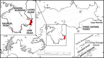
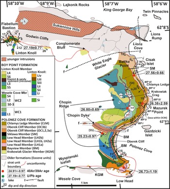
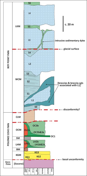
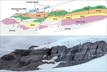
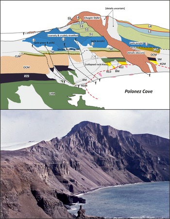
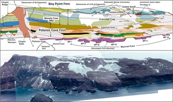
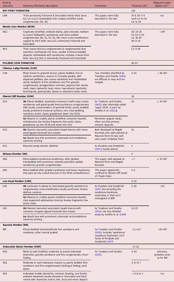
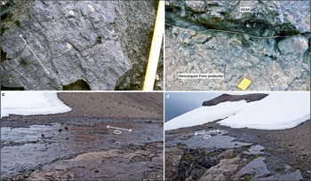
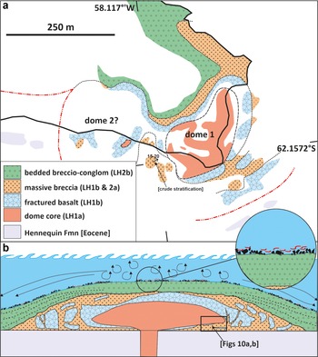
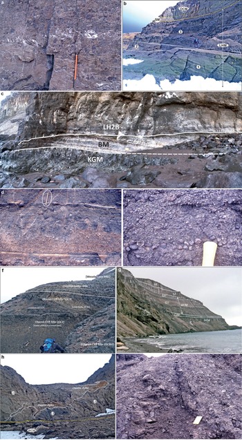
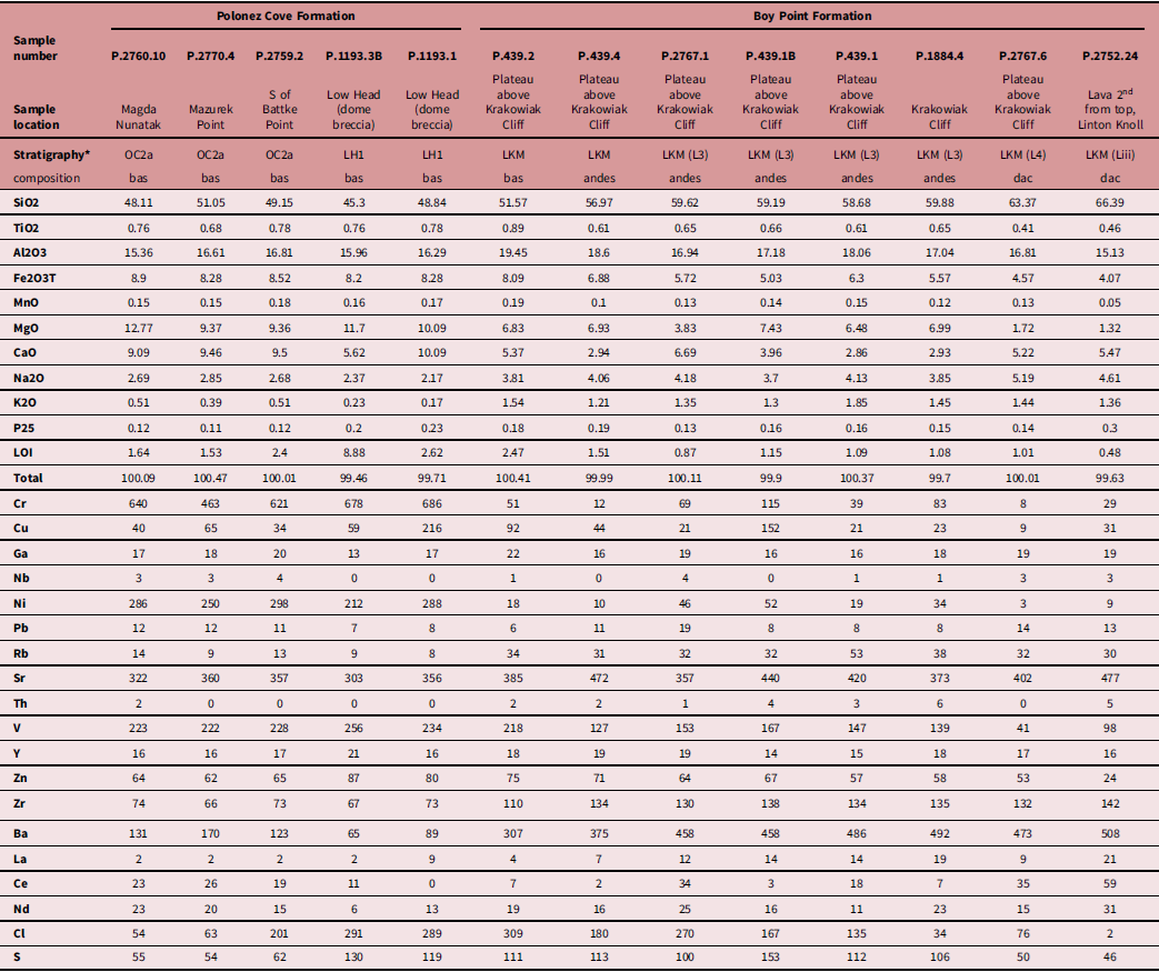
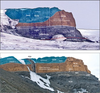
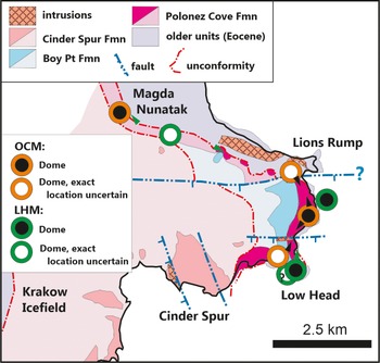
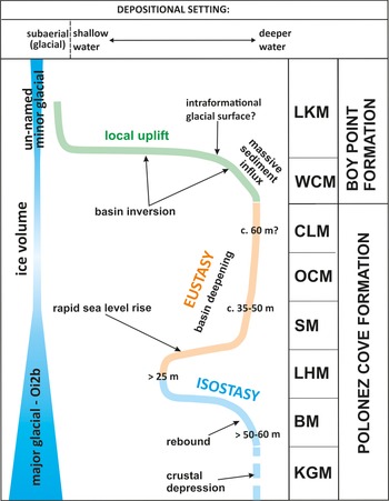
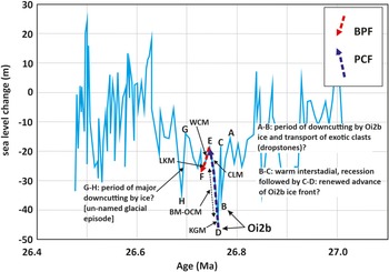
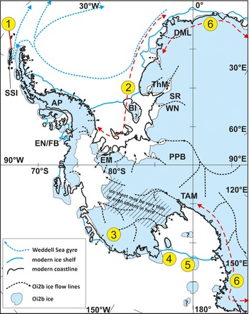


 Open access

