


Introduction
As indicated by Reference PatersonPaterson (1994), surging glaciers have been identified only in certain regions of the Earth, but these cover a wide range of climatic, morphological and geological situations: from polar to subtropical areas and from maritime to mid-continentalareas. Among the zones in which this type of glacier has been identified are the mountain chains of Alaska, U.S.A., and the YukonTerritory, Canada; Svalbard; Iceland; Greenland; the Russian High Arctic; and Asia (the Pamirs, the Tien Shan andthe Karakoram) (Reference HewittHewitt,1969,Reference Hewitt1998; Reference PostPost, 1969; Reference Mayewski and JeschkeMayewski and Jeschke, 1979; Reference WeidickWeidick,1988; Reference Dowdeswell, Hamilton and HagenDowdeswell and others, 1991;Reference Wake and SearleWake and Searle, 1993; Reference Heinrichs, Mayo, Echelmeyer and HarrisonHeinrichs and others, 1996; Reference Dowdeswell and WilliamsDowdeswell and Williams, 1997; Reference Jiskoot, Murray and BoyleJiskoot and others, 2000). Some great advances of this type of glacier are reported to have taken place in the Karakoram, although studies of surging glaciers of that region are few. In 1953, Kutiah Glacier advanced down an ice-free valley 12 km in 2 months (Reference DesioDesio,1954; Reference HewittHewitt, 1969). Such advances have practical consequences (e.g. blocking off access to the yak pastures or to trekking routes, as occurred in 1989 with Pumarikish Glacier, atributary of Hispar Glacier (Reference SearleSearle,1991)).
In this paper, we present some aspects of the recent history of Liligo Glacier, a small glacier in the Karakoram, Pakistan. Some of these historical data have already been used to outline the dynamics of several glaciers in Braldo valley during the 20th century (Reference Pecci and SmiragliaPecci and Smiraglia, 2000). This study aims to provide a critical review of the sources used, and a presentation of other sources of information on Liligo Glacier, such as cartographic sources and photographs (including satellite images).
Liligo Glacier is smaller than other known and studied Karakoram glaciers (none of which are known to surge), such as Siachen Glacier (75km long), Hispar Glacier (61km long) and Baltoro Glacier (58 km long). Liligo Glacier is about 10km long and has a surface area of about17km2. According to Reference MasonMason’s (1930) classification, it could be defined as a transverse glacier, which, with a short length and steep surface slope, flow sperpendicular to the longitudinal type and therefore is nearly perpendicular to the main axis of the range. In fact, Liligo Glacier is found in a transverse valley, which from a north-to-south direction enters the main Baltoro valley slightly upslope from the snout of Baltoro Glacier (Fig. 1). In the vicinity of the confluence of Liligo valley, camps are frequently set up as a starting point for expeditions headed towards the upper Baltoro. Thus, the Liligo Glacier terminus has been described and photographed by a number of explorers and mountaineers since the end of the 19th century.
Map of Baltoro Glacier and location of Liligo Glacier (arrow).The thick lines indicate the main mountain ridge; the lines indicate the glacier boundaries; black dots represent the main peaks.

Data Acquisition and Methods
A variety of sources were used to reconstruct the variations of the terminus of Liligo Glacier.These sources differ in the type of information provided and in their reliability. Only the field measurements, the large-scale maps and the satellite images offer quantitative data permitting correlation. The reports written by explorers and mountaineers are often subjective, while official medium-scale maps, usually prepared on the basis of older maps, are lacking in precision. The sources used for this paper are listed in Table 1, along with their degree of reliability.
Data sources and reliability evaluation

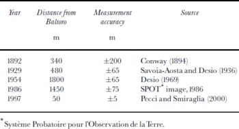
The sources listed above were screened, and only those offering “good” reliability were used, with the exception of the Reference ConwayConway (1894) map. For the maps, this reliability is based on: presence of a geographic grid or of trigonometrical or topographical points for georeferencing; map scale (at least 1:200000); type of survey; data sources; official evaluation. The maps were georeferenced by using a geographic information system (GIS) and finding at least 15–20 homologous points; the accuracy of these measurements (evaluated taking into account georeferencing errors and map scale) is reported in Table 2. The ground photos were compared with a recognition of the similar structures on the rock walls enclosing the glacier, as indicated (Figs 2–5). For maps and satellite images the distance between the terminus of Liligo Glacier and the southern margin of Baltoro Glacier was measured.
Liligo Glacier in 1909. The lines on the photograph show the rock structures used to georeference the photographs to those in other years. (Photograph by V. Sella, from De Filippi (1912).)

Liligo Glacier in 1953 .The lines on the photograph show the rock structures used to georeference the photographs; boundary of the glacier terminus is also indicated. (Photograph by A. Desio.)

Liligo Glacier in 1985. The lines on the photograph show the rock structures used to georeference the photographs; boundary of the glacier terminus is also indicated. (Photograph by C. Smiraglia.)

Liligo Glacier in 1997. The lines on the photograph show the the rock structures used to georeference the photographs. (Photog ra ph by M. Pecci.)

Variations of the Liligo Glacier terminus from the southern lateral moraine of Baltoro Glacier (measurement accuracy was evaluated taking into account georeferencing errors and map scale)
Terminus Variations of Liligo Glacier
On the map prepared by Conway in 1892 (Reference ConwayConway, 1894), the Liligo Glacier terminus is clearly separated from the side of Baltoro Glacier by a distance of about 400–500m. This distance was estimated taking into account the glacial stream’s point of origin. The lower sector of the glacier is abundantly covered with debris. In 1909, the terminus was still separate; without direct measurements, Reference De FilippiDe Filippi (1912) estimated the distance to be about 500 m. He noted the morphology of the terminus: “The Liligo glacier is very broken up with no surficial moraines, occupying at least the centre of its valley, with the terminus at a distance of about half a kilometre from the side of the Baltoro, with a steep front, a hundred metres high” (Reference De FilippiDe Filippi, 1912, p. 229). The morphology of the terminus is well illustrated in a splendid photograph taken by V. Sella and shown in Figure 2. This photograph also shows the rock structures, serving for comparison with the other photographs.
The map of Baltoro Glacier published by Reference Dainelli and MarinelliDainelli and Marinelli (1928) is very schematic. It indicates a terminus with little debris and two main medial moraines. In 1929, Desio observedaverydifferent morphology of the terminus: “It was possible to observe the lower sector of an ice flow so slight, narrow and thin, greatly covered by a surficial moraine, hidden downward beneath the glacial debris. . . The lower part of Liligo Glacier appears to be extremely reduced. The morainal slopes near the glacier appear to be very fresh and it is evident that they have been left by the glacier very recently. In this regard, the comparison with the situation of Liligo Glacier twenty years earlier, as shown in a photograph taken by Sella in 1909, is of particular interest. It looks as if, at that time, the glacier was advancing, whereas today it is retreating” (Reference Savoia-Aosta and DesioSavoia-Aosta and Desio, 1936, p.388–389, 396). The map surveyed on that occasion shows a frontal sector a little less than 500 m distant from the side of Baltoro Glacier and completely covered with debris, forming two medial moraines upslope.
The photograph taken by Desio in 1953 (Reference Pecci and SmiragliaPecci and Smiraglia, 2000) presents a picture similar to that in 1929, but the terminal sector is well within the valley, completely covered by debris and far from the rock structure on the wall serving as the reference point (Fig. 3). Thelarge-scale map of Baltoro Glacier surveyed by Desio in 1954 (Reference DesioDesio,1969) confirms this, and affords an estimate of about 1800 m for the distance of the Liligo terminus from the margin of Baltoro Glacier. The description, and the photographs taken, by Smiraglia in 1985 (Reference SmiragliaSmiraglia, 1987; C. Smiraglia, unpublished) reveal the terminus to be less covered by debris and probably less depleted (Fig. 4).
The SPOT 1 HRV1 201-278 satellite image of 22 June 1986, georeferenced using a GIS, shows the terminus at a distance of little less than 1.5 km from the side of Baltoro Glacier. The lower sector of the glacier is completely covered with debris which in the upper section is limited to two main moraines; between the two moraines numerous transverse crevasses are visible. For the early 1990s, the descriptions, photographs and distance estimates present a much-changed picture compared to the preceding sources, and one which resembles that at the beginning of the 20th century. The frontal sector, partially free of debris, bulging and heavily crevassed, had pushed on well below the reference structure on the rock wall, and, according to the measurements taken by Pecci in 1997, it was 50 m from Baltoro Glacier at that time (Reference Pecci and SmiragliaPecci and Smiraglia, 2000) (Fig. 5). The data on the frontal variations of Liligo Glacier are summarized in Table 2 and in Figure 6.
frontal positions of liligo glacier, 1892–1997.

Discussion
The sources, although diverse, offer indications for two strong terminus advances of Liligo Glacier. The first possible surge starts just before 1909 and terminates sometime before 1929. A strong retreat follows, lasting until at least 1954. Sometime after 1954 and before 1986, the glacier advances again (+350 m), and a further advance of almost 1500m occurs between 1986 and 1997. The data reported above do not permit an accurate definition of the beginning and end of the advance phases; the problem, as Reference Dowdeswell, Hamilton and HagenDowdeswell and other (1991) observe, is “the lack of time series of observations of sufficient resolution to pinpoint both surge inception and termination”. In particular, the date of the beginning of the most recent advance phase is not known. The position of the terminus in 1986 was closer to Baltoro Glacier than in 1954. It is also certain that the strongest and most recent advance phase occurred later and was in progress in 1996 (photographbyA. da Polenza). If we suppose that this last phase, which is quantifiable as an advance of 1450 m, lasted from 1986 to 1996 (probably an overestimate), an annual increase of about 140 m could be inferred. This advance rate is lower, and the duration longer, than that of other glaciers in the Karakoram known as surging glaciers (with advances of several kilometres in a few months, according to data collected by Reference HewittHewitt (1969)).Yet the assimilation of this glacier with others characterized by surges is certainly plausible.
As well as the terminus-advance rate and duration, the ice-surface features and the terminus characteristics are also important. They are used as indicators of surging glaciers and include: (a) looped and folded medial moraines, formed by the flow of ice from a tributary glacier while the main glacier is quiescent; (b) potholes on the glacier surface during the quiescent phase; (c) a heavily crevassed surface indicative of the active phase in the surge cycle (Reference Meier and PostMeier and Post, 1969; Reference PatersonPaterson, 1994; Reference Dowdeswell and WilliamsDowdeswell and Williams, 1997).
As Liligo Glacier has not been confluent with Baltoro Glacier for over a century, there are no traces of a looped moraine. However, the morphology of its frontal sector is significant, as can be observed in the photograph taken by V. Sella in 1909. As described by Reference De FilippiDe Filippi (1912), the front is a vertical ice cliff about 100 m high, in an advancing phase, as demonstrated by the cones at the base resulting from the continuous collapsing of ice. The entire glacier tongue, which is visible in the image, is heavily crevassed, with limited debris cover. Overall, its morphology resembles that of Kutiah Glacier in a surge phase, as shown in unpublished photographs taken by A. Desio in 1953 (personal communication from A. Desio, 1986). The same can be said for the situation in 1996–97, although the ice cliff does not appear to be as steep.
Conclusion
Using a variety of sources, this study detected at least two advance phases for Liligo Glacier. The first took place after 1909, and the second took place possibly after 1954 and accelerated in magnitude after 1986 (at least 1450m advance between 1986 and 1997). The duration of each surge has a large range of uncertainty as does the exact position of the glacier front at the beginning and end of the surges, so the terminus advance rates (145–75ma−1) have an even larger range of uncertainty. This yearly frontal advance is lower than the rate for other known surging glaciers in the Karakoram. But some ice-surface features, particularly the heavily crevassed surface in the mid-terminal sector of the tongue and the frontal ice cliff, observed in the historical images dating from the beginning of the 20 thcentury and in the more recent ones from the end of the 20th century, are another significant indicator. The lack of folded and looped moraines, which are clearly visible in the satellite images of other small glaciers flowing into Baltoro Glacier and in larger glaciers in neighbouring areas (a detailed analysis of these glaciers, and of the use of these ice-surface features as indicators of whether or not glaciers have surged, is now in progress), may be due to the fact that Liligo Glacier advances down an ice-free valley and has not flowed into Baltoro Glacier for at least a century. Taking these considerations into account, we believe that Liligo Glacier is a surge-type glacier, with phases of activity that have durations of decades and quiescent phases lasting almost 50 years.This confirms the inclusion of Liligo Glacier in the list of known and suspected surging glaciers reported by Hewitt (http://www.agu.org/eos_elec/97106e.html) for the last 100 years, most of which are transverse (like Liligo Glacier) or tributary glaciers and are comparable to Liligo in being of small to intermediate size and in being predominantly or wholly avalanche-nourished. Finally, it may be helpful to add that Liligo is the only ice mass in Baltoro basin classified by Reference KotlyakovKotlyakov and others (1997), using satellite imagery, as a definite surging type.
Acknowledgements
Theauthors dedicate this study to A. Desio, one of the greatest experts on the mountain sand glaciers of the Karakoram, who died in 2002 at the age of 104. This research was conducted as part of the Ministerio Istruzione, Universita, Ricerca (MIUR) 2001 Project,“Glacier retreat in the Italian Alps and climatic changes since the deglaciation to the present phase”. Field data were collected during the expeditions undertaken as part of the Ev-K2-CNR Project. The authors gratefully acknowledge the careful reviews by two referees, K. Hewitt and H. Jiskoot, and by the editor T. Murray, which greatly improved the manuscript.



