INTRODUCTION
In this article I discuss the aquatic lifeway in Michoacán, Western Mexico, from ca. a.d. 1540 to the present. The cultural activities linked to subsistence in aquatic environments (fishing, hunting, gathering, and manufacture) are seen here through the lens of ethnohistory, based on the major historical sources from the sixteenth century (and later) that deal with aquatic landscapes and resources in Michoacán and neighboring areas. Equally important is the perspective derived from ethnographic information about subsistence activities in the Lake Pátzcuaro Basin during the twentieth century. Lastly, the archaeological implications of all this information are discussed through an ethnoarchaeological study (conducted by the author in 2009) of the subsistence strategies and the material culture associated with the aquatic lifeway in the Lake Pátzcuaro Basin.
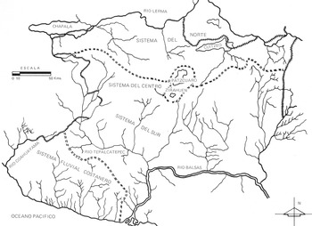
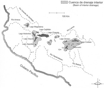
Michoacán owes its name to the Aztecs, who named the different regions of their ecumene, or known world, according to each region's most salient characteristics. The Nahuatl word Michoacan means “land of fish,” which is a very accurate description of this part of West Mexico, since it was covered by great lakes and countless streams, rivers, springs, marshes, and other wetlands (Figure 1). In order to understand the critical role of the aquatic landscapes and resources in the area under discussion, in the following pages I explain the most salient characteristics of the aquatic lifeway in Mesoamerica (Figure 2).
Many lakes, rivers, and wetlands have dominated the landscape of Michoacán for thousands of years, making this one of the most fertile environments in Mesoamerica. Adapted from Guevara (Reference Guevara and Florescano1989:24).

The basins of internal drainage of West Mexico as they existed around a.d. 1500, indicating the major archaeological sites of different periods: (1) Capacha; (2) Chupícuaro; (3) El Opeño; (4) Ihuatzio; (5) Loma Alta; (6) Loma Santa María; (7) Pátzcuaro; (8) Queréndaro; (9) Teuchitlan/Etzatlán; (10) Tinganio; (11) Tres Cerritos; (12) Tzintzuntzan; and, (13) Urichu. Base map adapted from Tamayo and West (Reference Tamayo, West and Wauchope1964:Figure 4).

Mesoamerica was the only civilization in history that was bereft of any kind of domesticated livestock, but despite this condition Mesoamerican foodways were among the most complete in ancient times. Most large, and potentially domesticable, animal species in the New World became extinct some 12,000–17,000 years ago; that is, right around the time that humans began to appear on the continent (indeed, it has been suggested that early humans contributed to the extinction of Pleistocene fauna; Diamond Reference Diamond1999).
The domestication of cattle, horses, pigs, sheep or other animals in the Neolithic (ca. 7000–2000 b.c.) in the Old World allowed human populations to considerably broaden the range of exploitation of their environment, since the anatomical adaptation of ungulates (primarily ruminants such as cattle, sheep, goats, and camels, among others) to a diet high in cellulose and low in proteins gave humans an indirect way of exploiting cellulose-rich plants, especially grasses and the boughs and leaves of bushes (Harris Reference Harris and Reed1977:220). This complex of domesticated animals (that provided wool, milk, and energy for field labor in addition to meat) never emerged in pre-Hispanic Mesoamerica. While this fact certainly had far-reaching implications for technology and culture, its primary impact was on the diet of ancient Mesoamericans. According to Parsons (Reference Parsons, Staller and Carrasco2010, Reference Parsons, Williams, Sánchez, Weigand and Gándara2011), the lack of domesticated herbivores obliged the ancient inhabitants of Mesoamerica to look for alternative foodways. And this meant exploiting nonagricultural resources, such as the aquatic animal and plant species that complemented basic agricultural products thanks to their high levels of proteins and nutrients (Parsons Reference Parsons, Staller and Carrasco2010, Reference Parsons, Williams, Sánchez, Weigand and Gándara2011).
Parsons (Reference Parsons2006) has developed an analytical perspective to illustrate the dependence of Mesoamerican peoples on a wide range of natural resources of aquatic origin (apart from agriculture) for their daily sustenance. He holds that nonagricultural resources from many lakes in Mesoamerica, particularly salt and edible insects (and perhaps algae as well), were so energetically and economically important as to attract large numbers of people to engage full-time in their extraction, processing, and distribution. Such an attraction would necessarily have been significant in sociopolitical terms. In Parsons’ (Reference Parsons, Mastache, Parsons, Santley and Serra1996:442) opinion, the beds and swampy shores of lakes should be considered in much the same way as agricultural land when we attempt to evaluate pre-Hispanic productive potentials and carrying capacities.
Rojas (Reference Rojas1998) provides another important point of view for this discussion, for she believes that few regions in the Americas had nonagricultural food resources as abundant as those of the Basin of Mexico, where fishing, bird hunting, salt production, and the capture of turtles, frogs, salamanders, small crustaceans, mollusks, and diverse insects and their larvae, as well as algae and other aquatic plants, all enriched the diet and subsistence of inhabitants from very early times. Each one of these activities has its own character and history, which can be reconstructed in part thanks to archaeological, historical, and zoological studies. The knowledge and remembrances of present-day inhabitants are also an invaluable source of information on local flora and fauna (Rojas Reference Rojas1998).
These abundant aquatic species represented a great natural wealth that had consequences for the sociopolitical organization of such Mesoamerican states as the Aztecs and Tarascans, who lived in an ecological context characterized by numerous large lakes, marshes, and other bodies of water. Because they had no domesticated cattle, Mesoamericans developed subsistence strategies that produced an aquatic lifeway that was unique in the ancient world (Diamond Reference Diamond1999; Weigand Reference Weigand2000). According to Sugiura et al. (Reference Sugiura, García and Aguirre1998), this “aquatic mode of subsistence” may be defined as a system that articulates all activities linked to processes established between human groups and their means of production. Thus, it is a specific response and interrelationship between people and their biophysical surroundings that develops to ensure their survival and reproduction as a group. The aquatic mode of subsistence is part of a broader system that consists of an ecotonal lakeside zone where two structurally distinct ecosystems—one aquatic, the other terrestrial—interact to produce an abundance of natural species.
The exploitation of this lakeside zone did not require complex technology; rather, it was based on the appropriate management of empirical knowledge related to exploitable resources, and on a set of basic tools or artifacts. The inhabitants of lakeside areas were not limited to exploiting the aquatic environment, for they widened their sphere of action to include the surrounding alluvial soils, indispensable for agriculture, and the forests beyond them (Sugiura et al. Reference Sugiura, García and Aguirre1998).
As discussed in Williams (Reference Williams2020), the aquatic lifeway was present in most of Mesoamerica throughout the whole of the pre-Hispanic sequence, from the Archaic period (Niederberger Reference Niederberger1976, Reference Niederberger and Graham1981, Reference Niederberger1987), the Formative (Coe Reference Coe and Benson1981; Coe and Diehl Reference Coe and Diehl1980; Serra Reference Serra1988), the Classic (McClung Reference McClung, McClung and Rattray1987), the Postclassic (Millhauser Reference Millhauser, Nichols and Rodríguez-Alegría2017; Rojas Reference Rojas1998), and persisting into the twentieth century (Albores Reference Albores1995; Parsons Reference Parsons2019; Sugiura et al. Reference Sugiura, García and Aguirre1998).
In some areas of Mesoamerica, such as the Basin of Mexico and parts of Michoacán, several elements of indigenous life, particularly those related to the sphere of material culture associated with an aquatic lifeway (i.e., fishing, hunting, gathering, and manufacture), were not greatly modified by Spanish influence after the Conquest. In fact, most of the techniques, tools, and artifacts survived into the early decades of the twentieth century (García Sánchez Reference Sánchez, Magdalena, Florescano and Acosta2004). On the basis of historical and ethnographic sources, an aquatic lifeway can be characterized by the three basic subsistence activities: (1) fishing, including not only fish but many other edible aquatic species, such as insects; (2) hunting, which includes semiaquatic species such as birds and reptiles, among others, as well as land animals that dwell in the lakeside area and the nearby forests and hills; and (3) gathering, which includes aquatic species (both edible ones and others used for manufacture, such as reeds) and land species, and thus encompasses a wide variety of wild resources (animal, vegetable, and mineral; García Sánchez Reference Sánchez, Magdalena, Florescano and Acosta2004). To these three activities we must add the manufacture of all kinds of artifacts and features that are indispensable for the subsistence and reproduction of human social groups, such as baskets, reed mats, and fishnets, among many others.
There is a great similarity worldwide in the nature of the tools, implements, and procedures used to obtain and process aquatic resources. In order to carry out these activities, a whole range of artifacts exists for “cutting, scraping, penetrating, grinding, gouging, boiling, and storage. These implements would have to be manufactured or acquired, and maintained or curated, repaired, and replaced” when broken or worn out. Likewise, “other implements would be needed to manufacture or repair such infrastructure elements as fishnets, traps, ropes, baskets, bags, boats, shelters, and pottery” (Parsons Reference Parsons2006:285).
What follows in the next section is a discussion of the natural environments and aquatic resources that were available in Michoacán during the early Colonial period, and by extension in the pre-Hispanic period as well.
AQUATIC LANDSCAPES AND RESOURCES IN SIXTEENTH-CENTURY MICHOACÁN
The natural setting where the Tarascans developed their culture over thousands of years is a remarkable one. According to Guevara (Reference Guevara and Florescano1989), the landscape in Michoacán is one of the most abrupt in Mexico with high elevations and deep depressions. The reason for this is that Michoacán is at the meeting ground of five of Mexico's largest physiographic units: (1) the Valleys and Wetlands; (2) the Central Sierra; (3) the Hot Lands; (4) the Southern Sierra Madre; and (5) the Coastal Region. Michoacán is certainly a land of bounty; indeed González (Reference González1991) wrote that from the perspective of geography and ecology, Michoacán can be considered a microcosm that comprises many, if not all, the regions found within Mesoamerica, a veritable “sample book” for the whole of Mexico. According to González (Reference González1991:15), traveling across Michoacán is equivalent to making the proverbial tour de monde, since the state has all kinds of topographies: mountains, forests, lakes, valleys, and rivers, where one finds “all climates, plants and animals.”
According to Guevara (Reference Guevara and Florescano1989), there are four great hydrographic systems in Michoacán, respectively covering the northern, central, and southern parts of the state, as well as the Pacific coast. Guevara tells us that the Northern System encompasses the Lerma River Basin, which is born in the Estado de México to the east of Michoacán, and ends its course in Lake Chapala to the west. The Lake Cuitzeo Basin, holding the largest lake in Michoacán, is part of this hydrographic system. Lake Chapala, meanwhile, is the largest body of water in Mexico, at the western end of Michoacán. The second hydrographic system discussed by Guevara is the Central System, which includes lakes Pátzcuaro and Zirahuén. Both lakes are located in one of the highest areas of the Transversal Volcanic Axis. The last hydrographic region discussed here is the Southern Hydrographic System. This system includes most of the rivers and streams of Michoacán. The most important rivers are the Balsas and the Tepalcatepec. The latter river is the largest and is important for agriculture, as it crosses the fertile Tierra Caliente, or hot lands of Michoacán (Guevara Reference Guevara and Florescano1989).
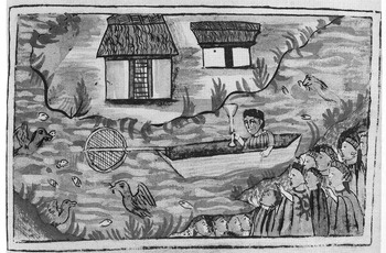
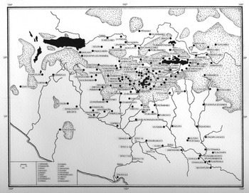
The main sources of information for our discussion of the natural resources and landscapes of the Tarascan territory at the first decades of the Spanish Colonial administration are the Relación de Michoacán (Figure 3), written around a.d. 1540 (Alcalá Reference Alcalá2008), and the Relaciones geográficas de Michoacán, written between ca. a.d. 1530 and 1580 (Acuña Reference Acuña1987). In the latter source we find detailed information about several areas within the Michoacán region, as well as the goods paid as tribute by the towns that had just been subjected under a new Colonial administration (Figure 4). The Relaciones geográficas are an invaluable source of information, since “all the informants, or most of them…were old men, of an age around 80 and 90 years. Living relics, therefore, of the pre-Hispanic world…both actors and witnesses of the drama of the Conquest” (Acuña Reference Acuña1987:333).
The Lake Pátzcuaro Basin was one of the richest ecological settings in Michoacán, where the aquatic lifeway flourished from early times, as seen in the Relación de Michoacán. Adapted from Alcalá (Reference Alcalá2008:Figure 33).

Map of Michoacán and adjacent areas with the main towns during the Protohistoric period (ca. a.d. 1450–1530). Adapted from Pollard (Reference Pollard, Williams and Weigand2011:Figure 1).

Another important source for the present discussion is the book called Libro de tasaciones de pueblos de Nueva España (González de Cossío Reference González de Cossío1952), and also the compilation of Colonial documents published by del Paso y Troncoso (Reference Paso y Troncoso1905) under the title of Papeles de Nueva España…Suma de visitas de pueblos por orden alfabético. Both books rely on previously unpublished documents housed in Spanish archives in order to discuss taxation, giving a clear panoramic view of the strategic resources that were available in each part of the province.
According to de Rojas (Reference Rojas1990), the tribute system in New Spain followed the customs of the previous indigenous Mesoamerican institutions, but the Spanish also introduced new changes. From the 1560s on, tribute was restricted to maize and money, and it decreased because of the high levels of mortality among the native population. Tribute obtained from the pueblos realengos, that is to say towns that depended directly on the Spanish Crown, was sent to the Real Hacienda (Royal Revenue Administration) in Mexico City, and from there was shipped directly to Spain. At the beginning of the Colonial era taxes were paid in kind, but from the second half of the sixteenth century, when there was more currency circulating in New Spain, the Spanish Crown tried to collect tribute from the Indians in money rather than goods (Paredes Reference Paredes1984).
It is not always easy to understand the levels and amounts of taxes paid in Michoacán during pre-Hispanic times, since we have neither codices nor other ancient documents similar to those from central Mexico and southern Mesoamerica. The data we have for the Colonial period are fragmentary and usually not very precise, so the projection of post-Conquest data to the pre-Hispanic past is not justified without further contextualization. Generally speaking, however, the Ordenanzas reales or royal ordinances (Zorita Reference Zorita1984 [1574]) allow us to assume that the amount of taxation in the Colonial period was not so different from the situation in pre-Hispanic times. An example of this information comes from de Zorita (Reference Zorita1984 [1574]:70), judge of the Audiencia of Mexico between 1556 and 1564, who wrote that “tribute should be less than what they paid in their times of infidelity.”
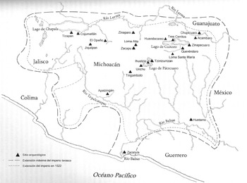
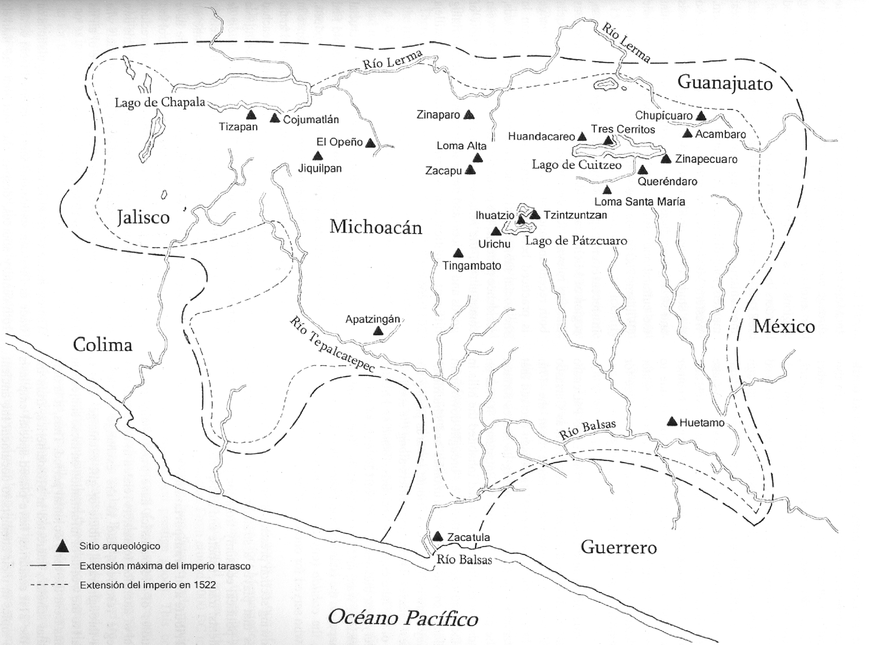
In the early sixteenth century, broad extensions of West Mexico were under the political aegis of the Tarascan Empire (Figure 5), known as Irechecua Tzintzuntzani, the second-most powerful empire in Mesoamerica after the Aztec Triple Alliance (Pollard Reference Pollard1993, Reference Pollard, Williams, Mestas and Esparza2009). In 1522, the king (irecha or cazonci) ruled an area of over 75,000 km2 that encompassed the greater part of the current state of Michoacán and portions of the neighboring states of Jalisco, Guanajuato, Colima, and Guerrero (Pollard Reference Pollard1993:Map 12). During the Protohistoric period (ca. a.d. 1450–1530), the Tarascan state may have been the most strongly centralized polity in Mesoamerica. In fact, this kingdom offers an example of state formation that shared some characteristics with ancient complex societies; namely, a high degree of centralization of power and economic activities, and rapid expansion. Its process of state formation, however, cannot be understood outside of historical and ecological contexts (Pollard Reference Pollard1993:181). The core geopolitical area of the Tarascan Empire was in the Lake Pátzcuaro Basin, where more than 90 communities were located with a combined population of between 60,000 and 105,000 inhabitants (Pollard Reference Pollard, Smith and Berdan2003).
Map showing the territory of the Tarascan Empire, encompassing the area of modern Michoacán and portions of adjacent states. The major archaeological sites are represented by triangles. Adapted from Pollard (Reference Pollard, Foster and Gorenstein2000:Figures 5.1 and 6.2).
When the first Spanish arrived at the Lake Pátzcuaro Basin around 1525, they found that fishing was one of the most important activities for the subsistence of all the towns around the lake, as shown by the Relación de Michoacán (Alcalá Reference Alcalá2008:29), which mentions a fisher in a canoe with many different kinds of fish with the following names: “Hacínnaran…and…hurápeti…cuerepun…thirón…charoé…There are so many kinds of fish here, all these I am seeking in this lake. By night I fish with net and by day with fishhook” (all translations from the Spanish are by the author). The species of fish mentioned by the Tarascan fisher have been described by Guzmán et al. (Reference Guzmán, Polaco and Pollard2001:157) as follows: hacínnaran (huacumaran in modern Tarascan), Algansea lacustris; hurápeti, Chirostoma estor; cuerepun, C. attenuatum, C. patzcuaro; thirón, Allotoca dugesi, Goodea luitopoldi, and Skiffia lermae; charoe (charal), Chirostoma spp.
The Relación de Michoacán tells an interesting story in which aquatic fauna is perceived to have magical undertones. This is the story of a group of fishers (at least some of them women) who “after much work looking for fish…came upon a big snake and…took it to their home with great happiness. The priests greeted them and said: ‘Welcome, sisters, have you brought even a small fish?’ to which they replied: ‘Lords, we found nothing, we do not know what this is.’” The priests informed them that “this too is fish, and it is edible. Roast it in the fire to take the skin off and cut it up in pieces and put it in the pot over the fire.” The fishers went home “to eat that snake boiled with maize…toward midnight…their feet had turned into a snake's tail, [and] they began to shed tears” (Alcalá Reference Alcalá2008:26–27).
The nutritional (and perhaps also ritual) importance of fish for the indigenous populations of the Lake Pátzcuaro Basin since early times has been underscored by recent excavations at Urichu, an archaeological site on the southwestern margins of Lake Pátzcuaro. Excavations in a complex of mounds and plazas at Urichu discovered a tomb made of stone alignments under the floor of an elite residential structure. The tomb contained at least 10 human interments and 87 funerary objects of the Late Classic and Epiclassic periods (ca. a.d. 500–900). Among the objects deposited inside the tomb there were four tripod plates containing fish remains of the species Goodea luitpoldi, locally known with the Tarascan name of t'iru (tiro in Spanish). This fish is part of Lake Pátzcuaro's indigenous aquatic fauna. This was the first archaeological evidence of the use of t'iru in the region, as well as the first record of an offering of fish from ancient times (Guzmán et al. Reference Guzmán, Polaco and Pollard2001:152–160).
Fishing was a strategic resource for the ancient inhabitants of the Lake Pátzcuaro Basin. Accordingly, we know that the Tarascan state had a whole administrative apparatus dedicated to the control and regulation of fishing and other productive activities. The Relación de Michoacán tells us that there was an official known as varuri, who was in charge of all the men who fished with nets and brought their daily catch to the cazonci (king) and all the other lords—“because this is the food of this people…The said varuri still has the custom of collecting fish from the fishermen” (Alcalá Reference Alcalá2008:177)—although fish were probably not as plentiful as before the Conquest. There was another official known as tarama, who was in charge of all the people who fished with fishhooks.
The information mentioned above is complemented by the Relación geográfica de la ciudad de Pátzcuaro (Acuña Reference Acuña1987), which mentions the natural resources and landscapes that were available in the Lake Pátzcuaro Basin during the pre-Hispanic period and the first decades of Spanish rule. According to this Relación geográfica, before the Conquest the local people “were sustained by maize, pumpkin, beans and chili peppers, deer meat and fish, which still are very abundant.” At a distance of a quarter league (1 league = ca. 4,828 m) north of the city of Pátzcuaro there was “a great fresh-water lake where a large amount of white fish is produced, which is very healthy and good…the Indians exploit [the fish] and are sustained by it” (Acuña Reference Acuña1987:200). Around this lake there were “many fertile towns and many orchards, which are barrios [neighborhoods] of this city [of Pátzcuaro]…and in the midst of the lake there are…small islands…and all the inhabitants are fishers” (Acuña Reference Acuña1987:201).
At the time of the Spanish arrival in the Tarascan region, all towns within the Lake Pátzcuaro Basin were under the control of Tzintzuntzan, the capital of the Tarascan Empire (Pollard Reference Pollard, Foster and Gorenstein2000). Among these towns was Tiripetío, which had existed since the late thirteenth century or early fourteenth century, before the beginning of the empire. Tiripetío may have been a small chiefdom that had been subjected by Curíngaro, a more prosperous town, until it fell under the aegis of the Tarascans around a.d. 1540 (Cerda Reference Cerda2000:11). We read in the Libro de tasaciones de pueblos that Tiripetío in 1551 was part of the encomienda of a certain Juan de Alvarado, who received as tribute four Castile chickens and 10 loads of grass, six loads of firewood and two loads of ocote (i.e., resinous wood), as well as “three Indians to carry water.” On “fish days” instead of the chickens the town had to pay 80 eggs and 40 “good-sized fish” (González de Cossío Reference González de Cossío1952:483–486).
Another important source for this town is the Relación geográfica de Tiripetío, which states that the town of Tiripetío “from its inception was a subject of the king of Michoacán.” The town “paid as tribute turkeys and chickens of the native kind…[and] firewood and the labor of men and women, as well as soldiers for fighting in the wars against the Mexicans [i.e., Aztecs] and Matlatzingos [i.e., Matlazincas]…the firewood was [used] for the fire that was always burning in their altars” (Acuña Reference Acuña1987:341). The locals ate on a daily basis “maize bread, tortillas and tamales. The tamales are made of maize dough, mixed with beans and wrapped…in a maize leaf” (Acuña Reference Acuña1987:341). Apart from maize, they also ate beans, chili, and the meat of deer, turkey, wild chickens, rabbits, quail, and ducks. “All these things were plentiful. And they ate many kinds of fish, because Lake Pátzcuaro was nearby…they caught great amounts of white fish, and others with beard and one called chegua which is very good and is the most common. There is another small fish like the pejerrey [Odontesthes bonariensis, a species of Neotropical silverside], which they catch in such quantity that it is eaten in all parts of New Spain” (Acuña Reference Acuña1987:341). There were three rivers near Tiripetío where the locals caught a species of shrimp that was also plentiful, according to the Relación geográfica.
In describing the landscape where Tiripetío was located, the Relación geográfica says that the town was sitting on a natural elevation or knoll and some of the houses were on the plain below, between the knoll and a marsh, which was “one of the most fertile [places] found in this land…Three creeks run through it…throughout the year there is no lack of grass [and] a thick reed…Many wild ducks, geese, and other birds breed in this marsh” (Acuña Reference Acuña1987:342). Shrimp were found in the creeks mentioned above, as well as a tiny fish called zizito. The knoll where the town was located was somewhat rocky, but they were able to grow maize and chía (Salvia hispanica) “like in the most fertile lands of the province.” Beyond the marsh there was a great plain where the locals had their farmlands, “because they can make many irrigation ditches from the creeks…around this town there are many hills and plains, gullies and streams, [and] so many water springs that they cannot be counted…the wooded hills are so numerous and so thick that they could never finish…This town has more than eight lakes and the most fertile lands and wooded hills in New Spain.” The trees found in this jurisdiction were great “pines and cedars and…oyamel [a conifer, Abies religiosa], the tallest and thickest tree in the whole of the Indies” (Acuña Reference Acuña1987:354). The Relación also mentions the following useful trees: encinos, robles (Quercus spp.), and madroños (Arbutus bicolor).
The Lake Cuitzeo Basin, near Lake Pátzcuaro, was also a key economic area for the Tarascan Empire during the Protohistoric period, because of the existence of several strategic resources that were lacking in the Tarascan core at the Lake Pátzcuaro Basin, such as obsidian, salt, and lime, among others. Likewise, there were extensive geological deposits of copper, silver, tin, and gold located near Lake Cuitzeo (Williams Reference Williams2020:Figures 289a–289c). This basin is located in the Lerma River region, which had an outstanding natural endowment consisting of forests, rivers, marshes, and abundant fertile land (Weigand and Williams Reference Weigand, Williams, Williams and Weigand1999).
In this part of Michoacán during the Protohistoric period (and probably since much earlier) there was an abundant production and exchange of several strategic resources, including the minerals named above and other products, like aquatic flora and fauna, which would become indispensable for the economy of this part of Mesoamerica. The role of the Lake Cuitzeo Basin as a strategic region of the Tarascan Empire can be seen in the Relación de Cuiseo de la Laguna (Acuña Reference Acuña1987). This early Colonial document states that the people who lived in the Lake Cuitzeo area “were subjects of the king of Tsintsontsa [Tzintzuntzan], capital of the province of Michoacán, to which they gave personal service…and…each Indian gave as tribute one cotton mantle…likewise they gave a gourd of honey from a tree…called acanba [akamba, or maguey, i.e., Agave sp.]…There is in this town of Cuitzeo a lake where all the Indians of this district live” (Acuña Reference Acuña1987:82). Fish were plentiful in Lake Cuitzeo, as mentioned by the Relación de Cuiseo: “This lake has a kind of fish as big as the little finger, called in their tongue charao (charal or charare, Chirostoma sp.), a fish most appreciated by them…they catch great amounts [of fish] and people come from other provinces to exchange it for cotton and cacao, which is a currency they use in this land…they also bring many fruits and take back this fish rather than pesos” (Acuña Reference Acuña1987:84). The Relación de Cuiseo mentions many other fish species from Lake Cuitzeo, such as curengue (curengari), native to this lake, which was “as big as a sardine,” and may be the same species called akúmarha (Algansea Iacustris) by the Tarascans of Lake Pátzcuaro (Argueta Reference Argueta2008). The aquatic fauna of Lake Cuitzeo included frogs, which together with many fish species “were caught in great quantity and taken to their markets where many people come from other provinces” (Acuña Reference Acuña1987:86).
Apparently, by the middle of the sixteenth century there were few extensive forested areas around Lake Cuitzeo, but we do not know if this was due to deforestation after the Conquest, or was part of a long-term natural process (Butzer and Butzer Reference Butzer and Butzer1997). In this respect, the Relación cited above states that “this district is lacking in woods…there are…small wild trees used for burning. There are no trees for building houses” (Acuña Reference Acuña1987:86). On the other hand, in the Cuitzeo district figs were produced in abundance, tunas or prickly pears were also abundant, and “in all subject [towns]…there is much maize” (Acuña Reference Acuña1987:86). Among the bushes and smaller plants mentioned by the Relación de Cuiseo were many species with medicinal properties, such as “a herb they call andumucua [tobacco, Nicotiana sp.] which is much appreciated among these natives…they bring it in their mouths, chewing it like a piece of bread…it gives them so much heat and strength, that although they are working they need little food” (Acuña Reference Acuña1987:86). This species of tobacco had “the property of making one drunk” and was also “good for pain in the loins…and for toothache” (Acuña Reference Acuña1987:87).
The Relación de Cuiseo mentions a tree called chupirini (Euphorbia calyculata), which was used to cure the inflammation of the groin area, and the juice of the saúco leaf (Sambucus nigra) taken as diuretic and laxative, among other uses. There was a root called anbanduria that was “mashed together with tallow and applied to broken legs or arms, and within nine days” they were whole again (Acuña Reference Acuña1987:88).
As for the wild animals that lived in the Lake Cuitzeo Basin, the Relación de Cuiseo mentions several species that were important for the livelihood of the people in the region. These animals included both “wild chickens” (i.e., quail), and “chickens from Castile” (i.e., the species brought over to New Spain by the Spanish settlers), while on the lake “by the month of December there is such an amount of ducks, egrets and alcatraces [aquatic birds belonging to the order of the Suliformes] that they cannot be counted. The natives enter the lake by night in their boats with small fires, in order to catch the said birds, which are attracted by the light and the natives kill them with bow and arrow” (Acuña Reference Acuña1987:88). So many birds were killed in this manner and “so many are brought to the markets that it is a frightful thing” (Acuña Reference Acuña1987:88). Ducks accounted for the majority of birds hunted, but the Relación de Cuiseo mentions many other birds that were brought down by hunters in the Lake Cuitzeo Basin: quail, crows, thrush, doves, hawks, and also mammals such as deer and rabbits, while wolves and foxes may have provided furs (Acuña Reference Acuña1987:88).
Apart from the numerous animal and plant species that were useful to the local population of the Lake Cuitzeo Basin, many mineral resources were exploited as well. One of the most important commodities was common salt, or sodium chloride, which is still exploited in the Lake Cuitzeo Basin (Williams Reference Williams2015, Reference Williams2018a), together with tequesquite, a salty earth that was used for making soap and is still important as a complement of cattle feed. These resources were noted by the Relación de Cuiseo, where we read that when the waters of the lake retracted they left the soil covered with tequesquite. The salty earth in and around the lake shore supported a diverse vegetable population, including a plant called curiraxacua (Acuña Reference Acuña1987), a halophyte plant that, thanks to its rich salt content, was especially good for glass making—so much so that glass makers used to come all the way from Mexico City to Lake Cuitzeo in order to obtain this plant (Escobar Reference Escobar and Reyes1998:169).
Another source of information about Lake Cuitzeo during Colonial times is known as Descripción…de Cuitzeo de la Laguna (Voto Reference Voto1777), which mentions that the water of this lake was so rich in minerals that its only use, apart from making salt, was for raising the tiny fish called charare (charal), with which the Indians of the surroundings supported themselves. The towns of Araró and Zinapécuaro, located on the eastern end of the Lake Cuitzeo Basin, appear in a historical record of taxation in sixteenth-century New Spain called Libro de las tasaciones de Nueva España. According to this source, both towns had to pay taxes in maize, chili peppers, beans and wheat, and also gourds, sandals, salt, and fish. All these items had to be taken by the Indians themselves to the mines at La Trinidad (Sultepec, Estado de México). They also had to provide their calpixque (i.e., foreman) with “two chickens, a dozen quail, two rabbits; on fish days the necessary fish and one dozen eggs and tamales for his servants; grass and firewood, and every fifty days fifty [wild] cat skins” (González de Cossío Reference González de Cossío1952:49).
Meanwhile, the Suma de visitas states that not far from Zinapécuaro there is a town called Ucareo, which “is located on a high flat knoll. This is healthy and temperate land, it has good earth and there is a mine of stone blades” (i.e., obsidian; Paso y Troncoso Reference Paso y Troncoso1905:294). The Suma de visitas also gives information on Araró, stating that this town had three barrios with 70 houses and a total of 255 persons, not counting children of less than three years of age. Araró paid in taxes on a yearly basis 150 pesos of common gold and 500 fanegas (or hanegas) of maize (1 fanega = ca. 55 liters), plus 30 cargas or loads (1 carga = ca. 40–50 kilograms) of salt, and 30 cargas of chili peppers. The Suma de visitas also mentions irrigated farmland with many blackberry groves, as well as plentiful fish stocks, the aforementioned local salt industry, and many thermal springs (Paso y Troncoso Reference Paso y Troncoso1905:32).
At a distance of some seven kilometers north of Lake Cuitzeo is Lake Yuriria. Here the Colonial sources described “a province that has everything: plains and hills…water sources and a great river, with abundance of fish called bagres [i.e., catfish]…this land is plentiful in maize…a ditch made from the said river waters a plain of five leagues in circumference, creating a large lake where the natives kill many fish” (Acuña Reference Acuña1987:68–71). The Spanish source mentioned above seems to indicate that the fish stocks were managed in a sort of “hatchery” or “fish farm” (granjería). In addition to fish and other aquatic species, the fauna around Lake Yuriria included mountain lions, wolves, coyotes, deer, hares, rabbits, and many different kinds of birds. The locals used to “pay their tribute in money and maize, and [they] trade in the fish of the said lake and river” (Acuña Reference Acuña1987:71).
The Suma de visitas gives additional information about the town of Yuririapúndaro, which was located on the southern margins of Lake Yuriria. This town, together with four cabeceras (i.e., head towns) in the region, had to pay tribute in the form of “forty Indians in the mines of Taxco” (Guerrero) (Paso y Troncoso Reference Paso y Troncoso1905:131). These towns had farmlands from which taxes were paid in the following amounts: “Five hundred hanegas of maize, and…thirty hanegas of beans, and…of wheat…one hundred hanegas” (Paso y Troncoso Reference Paso y Troncoso1905:131). Yuririapúndaro was located “on a stony slope near a river and a lake with plenty of fisheries. This is temperate and healthy land, where cotton and all other supplies are found” (Paso y Troncoso Reference Paso y Troncoso1905:132).
Some of the tributes extracted by the Spanish Crown from this rich region were used for supplying food and other necessities to the silver mines in other areas of West Mexico, as stated in the Tasación del Bachiller Juan de Ortega, written in 1528: “The lord of Urirapundaro [Yuririapúndaro] says he will deliver for his master 220 loads of fish at the mines…The lord of Cuyzeo [Cuitzeo] will give his master 400 loads of maize and 30 loads of fish and 40 of beans and 40 of chili peppers and four of salt…The lord of Chocándiro…100 loads of supplies…six loads of chili…six [loads] of salt and two of fish” (Warren Reference Warren1989:422–423).
From the Yuriria and Cuitzeo lake basins we go west to the town of Jacona (Xacona in Figure 4), where archaeological research has discovered human presence since at least the Formative period (see discussion in Williams [Reference Williams2020:ch. IV, pp. 114–120]). During the first century of Spanish domination, Jacona was an important settlement, and in 1544 the tribute paid to the Crown included the obligation to “take to the mines…30 loads of beans and five of chili, fifteen loaves of salt and 25 xiquipilicos [small bags] of pinol…60 pairs of sandals…100 jícaras [gourd bowls]…three loads of fish…four chickens every day for the calpixque…200 tamales…and eggs” (González de Cossío Reference González de Cossío1952:213). Jacona is located in the midst of an extensive aquatic landscape; an extremely rich region endowed with many natural resources, as seen in the following extract from the Suma de visitas: “Jacona…has six subject head towns, each one paying [its own] tribute…in total four thousand three hundred and sixty one tribute payers of all kinds…They have good lands for all sorts of supplies, they reach part of a salty lake where they have good fisheries…[and] some small farms…on the islands in this lake” (Paso y Troncoso Reference Paso y Troncoso1905:302).
The Jacona and Zamora valleys in northwestern Michoacán are among the most fertile agricultural areas in Mexico. This is due in part to an abundance of water in this area, which was covered by lakes and marshes in the past. Thanks to the location of the pre-Hispanic settlements in relation to the wetlands, as well as the abundant natural resources, subsistence activities such as fishing, hunting, and gathering were important means of exploitation of the environment. But farming was no less important, as the aquatic environment enabled people to develop intensive agricultural systems. The terraces and bancales (i.e., modifications of the hillslopes consisting in a combination of ridges and ditches) deserve special mention, such as the ones found on the north slope of the Cerro de Curutarán (the major geological formation in the Jacona Valley), as well as the possible existence of chinampas (i.e., raised fields built in marsh areas) in the valleys (Sánchez Reference Sánchez2007). Sánchez (Reference Sánchez2007) describes a pre-Hispanic terrace system in the valley of Jacona, extending over a surface of some 70 hectares, while the bancales in the same area were also important as part of the farming systems used by the native Tarascans. After more than four centuries of landscape modifications, and in spite of many changes brought about by different political, economic, and social processes, the pre-Hispanic bancales are still visible, indicated by subtle changes on the landscape as well as by the associated archaeological materials on the surface (i.e., stones). A rough estimate of the area covered by these agricultural fields would be of about 120 hectares (Sánchez Reference Sánchez2007:18).
Sánchez (Reference Sánchez2007:19) tells us that because of “the partial inundation of the Zamora Valley during the months of June to September, and the formation of marshlands in the vicinity of Jacona, it is understandable that the earliest inhabitants of the region settled in the areas around the valleys, usually in places higher than 1,600 meters above sea level.” Sánchez (Reference Sánchez2007) sums up his discussion of pre-Hispanic subsistence around Zamora and Jacona by stating that when the Spaniards first arrived here, they found a landscape characterized by extensive wetlands, but the local environment had been modified and adapted by systematic transformations during many centuries before the Spanish conquest, indeed long before the inception of the Tarascan Empire (early fifteenth century).
The historical information described above can be used to underscore the aquatic orientation of the lifeway of the first inhabitants of this part of Michoacán. Comparisons with other areas of Mesoamerica, such as the Basin of Mexico (Berdan Reference Berdan2014; Hirth Reference Hirth2016) and the Upper Lerma River (Albores Reference Albores1995; Béligand Reference Béligand2017), offer another fruitful approach to answering the question of how the early michoacanos thrived in the environment just described (see discussion in Williams [Reference Williams2014a:ch. V, pp. 267–316]). The ancient people who lived in the Jacona Valley were able to adapt to their environment, and to modify the land in order to produce an agricultural surplus. In addition to farming, the aquatic lifeway based on fishing, hunting, and gathering was the most efficient system of food procurement, especially in a cultural setting that lacked cattle. Because of its high productivity, this aquatic lifeway was able to persist in many areas of Mesoamerica—Michoacán in particular—after the Spanish conquest (Williams Reference Williams2014a).
One of the few remaining areas in Michoacán where Tarascan culture has persisted to this day is La Cañada de los Once Pueblos, a small valley running from east to west on the borders of the Meseta Tarasca (Williams Reference Williams2017, Reference Williams2018b). La Cañada has many water sources and very good soils, which have turned this area into a major agricultural producer, as well as an outstanding setting for human occupation from pre-Hispanic times to the present (Ramírez Reference Ramírez1986:53). The administrative center for La Cañada is located at Chilchota, a town that was already important in Colonial times, as stated in the Relaciones geográficas pertaining to this part of Michoacán: “The town of Chilchota is located in a valley…with many high hills around it…which attract the clouds and it is always raining [on the hills]. They have many forests of very tall pines…oaks…and madroño [madrone, i.e., Arbutus sp.] and other wild trees” (Acuña Reference Acuña1987:102). According to the Relación de Chilchota, this town was “surrounded by many springs and rivers. A river flows near the houses on the north part [of the town] with beautiful water…the natives benefit from the river…irrigating much land where they get much wheat…maize and other seeds and greens…on the [southern] part of…Chilchota there is a source of wonderful water, with good taste and temperate…all day long people are bathing here” (Acuña Reference Acuña1987:102). This source of water was “so plentiful…that a river is formed which can only be crossed by a bridge…this river is joined by another river formed from great water springs in a valley half a league away…there are many water sources. They are so strong and so much water comes out of them…that all can be used for irrigation” (Acuña Reference Acuña1987:103). The local people of La Cañada caught many different species of fish in this aquatic environment: “Medium-sized fish, mojarras [Fam. Gerreidae] and bagres [Fam. Cyprinidae ]…This river…carries much water…in some parts its banks are covered by many woods with very tall trees” (Acuña Reference Acuña1987:104).
As one drives on the highway that runs along the Cañada, it is still possible to see traces of ancient agricultural terraces on some of the hills. One reads in the Relación de Chilchota that the terraces consisted of “stones set by hand, like steps, leaving between each step a space of one vara [ca. 85 centimeters], where they grow maize…and judging by these constructions in other times there must have been a great number of people here” (Acuña Reference Acuña1987:104). The natural resources of La Cañada, both agriculture and the local fauna, were still being exploited during the sixteenth century pretty much in the same way as in pre-Hispanic times, according to the Relación de Chilchota: “They grow in this town many fruit trees…also wild grapes…avocados, berries called xenguas in their tongue, and in Mexican [i.e., Nahuatl] called capolíes [shengua or capulín, Prunus capullin], there is also much maguey [Agave sp.] and maize…the hills and mountains are very tall and…there are many deer, tigers [jaguars] and lions [cougars]…and wild chickens” (Acuña Reference Acuña1987:105).
The same Relación quoted above describes the pre-Hispanic houses at La Cañada, which consisted of “adobe walls with a very beautiful straw roof…they sleep on the floor, on reed mats…they……[eat] tortillas of boiled maize and tamales…and deer meat, snakes, mice, gophers and worms…they eat worms [i.e., grubs or larvae] which they raise in the honeycombs that are so plentiful in this land…made by bees in the hills” (Acuña Reference Acuña1987:109). The people of La Cañada included in their diet many items that were often described as “vermin” by the Spanish chroniclers, such as locusts. Many wild animals were eaten, while the only domesticated edible species was the dog. The list of animals that were eaten regularly includes “badger, otters like the ones that are in the water, and dogs that they…fattened like pigs.” All these foods were accompanied by drinks of “maize and maguey wine” (Acuña Reference Acuña1987:109).
We should also mention the medicinal plants that were abundant in the region of La Cañada. People here used to “cure themselves with some salutiferous herbs that are in this town [i.e., Chilchota]…there is an herb…that grows in the wettest areas…and…on the river banks…which in the native tongue is called guenberecua [Tarascan uembérikua, or Rhus toxicodendron]…if someone has an ache…he takes this herb, removes the leaves and applies the [substance] oozing from the herb…this way it takes away the pain” (Acuña Reference Acuña1987:110). Another herb was “called tuesten [Tarascan tarepeni, or Oenothera sinuata] which is similar to salvia. If a wound is bloodied or cancerous, they apply the leaves…and it makes it better…it does not ache…Another herb is called yuracsen…[used] to cure old sores” (Acuña Reference Acuña1987:110). Trees were also exploited for their therapeutic properties, like the one “called chupire…meaning ‘tree of fire’ [Tarascan chupireni, or Euphorbia calyculata]…which gives milk…and it is a wonderful purgative…and is a remedy for all kinds of pustules” (Acuña Reference Acuña1987:110).
Aquatic birds, both migratory and resident species, were very abundant in the region of La Cañada in the sixteenth century: “In this land there are many ducks, geese, and cranes, from the month of October…until…March…It seems they come and go to and from the north” (Acuña Reference Acuña1987:111). Also present were various terrestrial bird species like “quail…wild chickens and…in the hills…many parrots, they are green talking birds” (Acuña Reference Acuña1987:111).
The forests in and around La Cañada have been decimated in the past decades, due to immoderate logging and clearing for agriculture. In the sixteenth century, wooded areas were plentiful and quite rich in natural resources, as we read in the Relación de Chilchota. The town of Urén is one of the 11 Tarascan towns in La Cañada, and a former subject of Chilchota. We learn from the Relación de Chilchota that the people of Urén “have many pine and oak woods near their homes…[as well as] a great amount of trees from which indigo is produced, which grow in the hills with no need for planting them” (Acuña Reference Acuña1987:115).
As for the town of Chilchota, the Suma de visitas states that Chilchota had only one barrio with a total of 131 houses and 971 people. They paid tribute to the Spanish Crown, including “thirty Indians delivered to the mines on a daily basis, and every twenty days forty Castilian chickens and ten hanegas of maize and six Indian servants. There are in this town irrigated lands, it is settled on a plain, it has a river and they grow berries, wheat, and many fruits, it has woods with pines” (Paso y Troncoso Reference Paso y Troncoso1905:78).
The ethnohistorical information discussed above is complemented by the writings of Rendón (Reference Rendón1947), who conducted ethnographic fieldwork in the Tarascan areas of the Sierra and the Cañada in the winter of 1941–1942. She focused her work on the local culture, in particular hunting, fishing, and gathering as well as other subsistence activities. Rendón (Reference Rendón1947:207) stated that “usually during a meal, large amounts of wild or semi-wild herbs are consumed, boiled in water with salt, seasoned with lemon juice and mixed with chili peppers.” Small, black, mushroom-shaped roots boiled with honey made from brown sugar called uakares were sold locally, “though according to some people the honey is secreted when they are boiled. They were gathered from under the earth, therefore they were called roots, but they look more like mushrooms; they are eaten as a candy” (Rendón Reference Rendón1947:207).
Bitter tunas (i.e., prickly pear) called joconostli (Opuntia joconostle) were used like greens in churipo (a kind of beef soup) and for certain kinds of hot sauce. The nuríte kamáta “is a kind of gruel that is very popular among the Tarascans…they use a wild herb to make it, which is gathered in the hills by some people (especially women) who work gathering medicinal herbs” (Rendón Reference Rendón1947:207–208).
Squirrels were much appreciated in daily diets in the regions known as the Sierra Tarasca and the Cañada de Chilchota, where they were hunted by men on the outskirts of towns. These men also hunted deer, wild ducks, and other birds. If they had no rifles, they would use traps or snares. Squirrels were caught with nooses hidden in the trees, while doves were caught with traps placed in lakes or gullies. Finally, wild ducks were brought from nearby Lake Zacapu, a lake that is now virtually dried up (Rendón Reference Rendón1947).
Deer were sold singly or in small quantities by individuals who were full-time hunters. One of Rendón's informants in the Sierra region spent the entire day hunting, though he also had maize fields to tend to. He used to kill deer, which he sold together with beef from his farm (Rendón Reference Rendón1947).
In the Meseta and La Cañada the following insects were eaten: honeycomb worms or grubs, jicoteras (larvae of bees that make underground nests and produce a honey that is slightly fortified but quite tasty), tlalpanal (worms taken from certain plants), and worms from the tejocote (Crataegus mexicana). The local diet also included crustaceans such as the chapus, or lake crabs (Rendón Reference Rendón1947).
The wild animals most commonly eaten or used as medicine were the following: huilotas (turtledoves), rabbits, various species of squirrel, deer, gophers, field mice, wild pigs (peccaries), hares, foxes, opossums, and skunks (the latter were used as medicine to cure skin diseases, blood disorders, and pneumonia; Rendón Reference Rendón1947).
La Cañada is located at the foothills of the Meseta Purépecha or Meseta Tarasca (Ramírez Reference Ramírez1986), one of the four areas of Michoacán where Tarascan culture is still present in force (the Cañada, the Meseta, the Lake Pátzcuaro Basin, and the Lake Zacapu Basin). Among the few historical sources for the Meseta Purépecha is the Relación de Tingüindín, which tells of the life and customs in that town in the late sixteenth century. According to this Relación, “the town of Tingüindín sits on flat land surrounded by high hills and mountains, with many pine and oak trees…water currents, flat lands…and much grass and fruits, both wild and from Castile…maize, wheat…and orchards of many other vegetables” (Acuña Reference Acuña1987:320). This region of Michoacán was under the aegis of the Tarascan Empire. Accordingly, the Relación de Tingüindín states that “this whole province paid tribute to the king called Catzontzi [sic]…gold, silver and copper, and…stones of great value…they worked…in the fields and..as soldiers for the king in the wars…that were continuously held against the provinces of Mexico,” that is to say the Aztec Empire (Acuña Reference Acuña1987:321). The local population relied for their sustenance on “maize and deer meat, chickens, wild pigs, grasshoppers, mice, snakes, beans, pumpkin, chili peppers and many other poisonous vermin like snakes that grow on the earth,” while “people who fall sick are cured with many different herbs found in this province” (Acuña Reference Acuña1987:322). The landscape where Tingüindín is located was quite bountiful in the time period under discussion, particularly in terms of aquatic environments and resources: “The said town is located at the foot of a high mountain…and out of this mountain…flow three streams as wide as a bull…where much wheat and maize can be irrigated, and many other vegetables, both native and from Castile” (Acuña Reference Acuña1987:322). At a distance of two leagues from Tingüindín there was “a lake of clear and fresh water, good for drinking and deep…the said lake breeds many good white fish, and other kinds of large and small fish…and frogs…There are many wild trees…pines, sabines, oyameles [firs], oaks, ash trees, saúcos [Sambucus sp.]” (Acuña Reference Acuña1987:322). The resin from pines and other trees was used as medicine, while other resins were used for lighting, and wood was used for making boards and beams for building their houses. Fruit trees were plentiful, including avocado “and many other fruits [good] for eating…the native grains are beans, chili, bledos [i.e., chenopods], pumpkins, ayotes [i.e., squash, Cucurbita moschata] and many other things…many medicinal herbs” (Acuña Reference Acuña1987:322). The Relación de Tingüindín includes a list of medicinal plants, including vellorita (Bellis perennis), used for curing sores, burns, and blisters, and to reduce inflammation. Picete or tobacco (Nicotiana sp.) was also used as medicine, thanks to its narcotic, sedative, and vomitive properties, among many others. Another plant still used today is epazote or epazotl (Chenopodium ambroisides), an excellent remedy for stomach and intestinal ailments like indigestion, cramps, and ulcers. Lastly, the Relación mentions many other medicinal plants “of which they do not know the name” (Acuña Reference Acuña1987:323). The fauna in the area around Tingüindín was quite rich and varied, including “lions [i.e., cougars], tigers [i.e., jaguars], wolves, foxes, skunks, hawks of all kinds, doves, turtledoves, quail, crows, auras [i.e., vultures]…eagles…wild partridges, wild chickens…and…many kinds of birds…wild pigs and deer…everything is found in abundance” (Acuña Reference Acuña1987:326).
The Suma de visitas says that Tingüindín had one barrio with 180 houses and a total population of 856 people, not counting infants. They paid as tribute “eight Indian servants for the mines and they make one sown field of maize…[Tingüindín] is located on a plain near a sierra…it has a good creek, the fruits of Castile grow well” (Paso y Troncoso Reference Paso y Troncoso1905:254).
The Lake Zacapu Basin is located some 110 kilometers to the northeast of Tingüindín. The lake itself was drained at the turn of the twentieth century, in order to exploit its rich soils for agriculture. Thanks to the Suma de visitas and other early sources, we know that in the past this aquatic environment was a key area for human habitation: “Zacapu…has nine barrios and…they pay as tribute in one year 320 pesos…and 1,200 hanegas of maize…30 hanegas of chili peppers and the same amount of beans…plus 120 items of clothing for Indians, and each year 24 loaves of salt and 36 gourds, and…every 23 days Indian servants and the tamemes [i.e., porters] that were needed” (Paso y Troncoso Reference Paso y Troncoso1905:79). The people of Zacapu also paid “every day four Castile chickens, except on fish days, when they give 80 mid-sized fish and a gourd [full of] clams and 30 eggs; and every day 200 tamales and six loads of grass and four of firewood and half an hanega of maize” (Paso y Troncoso Reference Paso y Troncoso1905:79). The town of Zacapu was located “on a plain…it has some bare, stony and steep hills, and…a big valley…it has a great water source [spring] near the town from which a lake is formed, where there are clams and some fish; the natives live from fields of maize, [and] wheat is grown in the rainy season” (Paso y Troncoso Reference Paso y Troncoso1905:79).
Friedrich (Reference Friedrich1970) conducted ethnographic fieldwork in the Lake Zacapu Basin around the mid-twentieth century. His account of the aquatic lifeway in this region is very important, because the lake is no longer extant and many of the customs and natural resources he recorded are now lost forever. Friedrich (Reference Friedrich1970) made a systematic study of subsistence strategies in the area under discussion at a time when many aspects of the aquatic lifeway were still in existence, or were remembered by Friedrich's informants. Friedrich's findings can be of assistance in reconstructing the subsistence patterns of ancient times. Lake Zacapu and a nearby water spring called Ojo de agua were surrounded by willow trees, and were fed by the clear water of several natural springs. Both the economy and the worldview of the local people were defined in part by this peculiar ecological niche. This was a bountiful natural environment in terms of plant and animal species, which were exploited by means of fishing, hunting, gathering, and manufacture. There was some sexual division of activities in the exploitation of the local resources; for instance, women and children would excavate on the beach with sharpened sticks in order to collect clams or white roots. In just one hour they could fill a basket with sufficient material to prepare a nutritious soup (Friedrich Reference Friedrich1970:10–11, 15).
The wildlife used in the local diet included lizards, turtles, frogs, the achoque or salamander (Ambystoma sp.), snails, and shrimp. There were also many edible plants, such as grasses similar to spinach, as well as acorns, mushrooms, and wild roots, all of which were gathered in the fields and on hillsides. Many species of cactus provided tender leaves that were eaten with chili sauce, while the sap of the maguey plant was used to make pulque, a very nutritive alcoholic beverage.
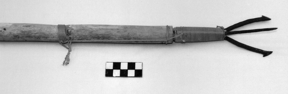
Local hunters used rifles to kill deer and keep badgers, foxes, and coyotes under control. The local water fowl were quite important for the domestic economy as well: ducks, divers, and many others that lived among the rushes and the extensive areas covered by marshlands around the lake. They were killed with 1.5 m-long wooden sticks, slings and stones, or the fisga, a long reed spear thrown with the help of an atlatl.
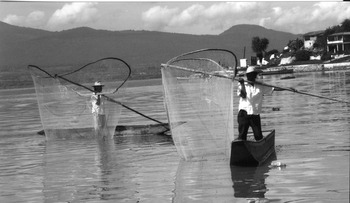
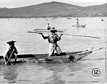
People of all ages and both sexes caught fish with small nets made of maguey fiber. The larger “butterfly net” (still seen on Lake Pátzcuaro) was used mostly by a single fisherman in a canoe, while the chinchorro or seine net (40 m long by one m high) required the collaborative labor of two or three men.
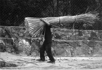
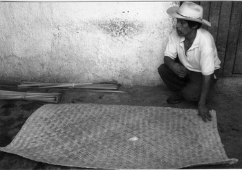
All adult men were tule weavers, at least on a part-time basis, and some 50 families were engaged in the systematic exploitation of the extensive areas of lake and marsh covered by rushes. This plant was used to weave mats of up to five m2. On average, one person could make between three and five mats in one day. Another kind of water plant exploited was the carrizo reed, which was used to make baskets, including the kinds called chiquihuites and tascales. A few families supported themselves solely by weaving carrizo containers, though most were also small-scale farmers.
Another region discussed here is the Bajío (lowlands), encompassing the Lerma River Basin, part of the Northern Hydrographic System. The Relación geográfica de la Provincia de Acámbaro (written ca. 1580) recorded the important economic role of Acámbaro and its subject towns for the Bajío region. This importance was due in part to the area's richness in aquatic resources. The Relación states that “in the tongue of the natives Acámbaro means ‘place of magueys’…a tree from which the Indians of New Spain greatly benefit…in some parts, because of two great rivers…there is much humidity…This whole land is quite flat, with many low, fertile plains…there are many groves of spiny trees called mesquites [Prosopis sp.]…which give a fruit…that is sustenance for the Indians” (Acuña Reference Acuña1987:59). The Relación…de Acámbaro describes a watery environment with many springs and “two very abundant rivers that surround [the area], very rich in fish called bagres [catfish] and…wild seeds with which the natives sustain themselves; therefore it is very rich in resources” (Acuña Reference Acuña1987:59).
Acámbaro is very near Lake Cuitzeo, one of the major salt producing areas of Mesoamerica, so it is not surprising that Acámbaro paid part of its tribute in salt, in addition to a whole range of aquatic products, especially fish: “Acámbaro…has four subject head towns…they all pay 33 Indian shepherds and 26 Indians for the looms…[and] every 20 days 24 loaves of salt…[Acámbaro] is located near a large river. It is a temperate land with irrigation…they grow cotton, [and] they can reach two rivers and a lake where they get abundant fish and salt…[in the] hills there are forests” (Paso y Troncoso Reference Paso y Troncoso1905:32–33).
Another place mentioned by the Relación…de Acámbaro is the town of Irámuco, located on the east side of the Lake Cuitzeo Basin. Near this town “there is a lake with some 30 leagues of circumference, which…produces plenty of fish for the surrounding towns. Likewise in another subject town called Aguas Calientes [hot waters] there are some springs with very hot water and…a lake…with some fish…all kinds of fruit trees from Spain grow here…and from the native [trees]…tunas [prickly pears]…and also cotton” (Acuña Reference Acuña1987:66). The following animals are mentioned by the same Relación: “Mountain lions, coyotes, wolves, and deer…hares, rabbits in great abundance, wild chickens, quail and Castile chickens” (Acuña Reference Acuña1987:67).
Some 58 kilometers east of Irámuco is the town of Santiago Maravatío, which could be the same as Maroatio in the Suma de visitas. Maroatio was located “two leagues from some mountain ranges…between the two rivers of San Miguel and Apatzeo…The trees on the Apatzeo River are many sabinos [Mexican cypress, Taxodium sp.], which are used for making boards for building houses, [and] there is an abundance of some wild trees called mesquites, which give fruit in little pods, very good to eat” (Acuña Reference Acuña1987:57–58).
The town of Xiquilpan (modern Jiquilpan, Michoacán) is located to the southeast of Lake Chapala, in a strategic position to exploit the natural resources of this lake basin, the largest in Mexico. Xiquilpan also enjoyed first-rate alluvial soils for agriculture. According to the Relación de Xiquilpan, “this town…is [on] temperate land…[nearby] flows a river, which never runs dry…and at one league…there is a lake…called Chapala, which is 40 leagues around, [and] plenty of fish are killed there, white fish [the famous pescado blanco, Chirostoma sphyraena ] and catfish, and a kind of small fish… a great and abundant river flows into this lake” (Acuña Reference Acuña1987:409). The same Relación tells us that Xiquilpan “is located on flat and level land, with no hills…there are some streams, there is plenty of water for the natives…This is very fertile land with many grasses, maize, chili, beans, and other seeds [that] are sown in abundance by the natives. There are wild fruits [such as] guamúchiles [Pithecellobium dulce], avocados, [and] guavas…anything grows on this land” (Acuña Reference Acuña1987:410). Before the Spanish conquest, the people of Xiquilpan produced “maize…chili peppers…and…tortillas, tamales, beans, and other wild herbs called quiletes [quelites, Amaranthus sp. and Chenopodium sp.] and they drank white wine from the maguey [i.e., pulque]…in this town and its subjects there are some maguey groves, on which the natives rely for their farms and their sustenance” (Acuña Reference Acuña1987:414).
The Lake Chapala Basin enjoyed a very rich natural landscape, which was exploited by many settlements for which we have historical information, such as Chapala, Cuiseo, and Poncitlán, among many others. In the case of Chapala, for instance, we learn from the Suma de visitas that this town, together with its dependencies, had “825 married people, 393 single people, and 349 young boys.” Chapala was located “on the lakeside and it has very good and fertile lands in which all the wild fruits and seeds are grown, and also wheat and all the fruits from Spain [as well as] sweet canes…they grow much cotton, and have great fisheries in the lake” (Paso y Troncoso Reference Paso y Troncoso1905:56–57). As for Cuiseo and Poncitlán, “these two towns are close together…they pay tribute jointly every two months: one hundred and five mantles…and one hundred Castile chickens and one nahuatlato [i.e., speaker of Nahuatl] in Guadalajara, and twenty Castile chickens every week, and on fish days forty eggs and fish and fruit…they give one thousand six hundred hanegas of maize…and ten loads of fish every Easter.” Cuiseo and Poncitlán “have some irrigated fields and estates, [and] great fisheries in the lake and river” (Paso y Troncoso Reference Paso y Troncoso1905:94).
The Suma de visitas mentions the following information about the town of Pajacuarán, located on the east side of Lake Chapala: “Pajacoran…is a head town and subject of Jacona; it has a barrio or island in the lake called Carao which has 34 houses and 366 people; this town is settled on an island…it is hot land. They give six…Indian servants and make a sown field of four hanegas of maize” (Paso y Troncoso Reference Paso y Troncoso1905:178).
Some 260 kilometers southeast of Lake Chapala, the town of Uruapan is located in a strategic position within the Meseta Tarasca (Tarascan Plateau), just to the north of the Tierra Caliente or “hot lands” region of Michoacán. Since the Colonial period, Uruapan has been an important city economically due to its location. According to the Suma de visitas, Uruapan “has two subject head towns, and…they give every 80 days 90 pesos…and twelve Indian servants…they make a sown field of wheat and one of maize…and they give every year ten hanegas of salt and ten of beans and ten salt loaves; and five months a year they give their calpixque every day two chickens.” The anonymous author of the Suma de visitas mentions Uruapan's strategic location between the cool highlands and the hot lowlands “in a valley that has…many water springs with which they irrigate many lands…they grow trees from Spain and berries… this land is in part hot and in part cold” (Paso y Troncoso Reference Paso y Troncoso1905:122).
The last region of Michoacán discussed here is the Tierra Caliente, encompassing the drainage of the Tepalcatepec River and its environs. The Tierra Caliente was of strategic importance for the Tarascan Empire, which controlled this resource-rich region from around a.d. 1450 until the Spanish invasion. The Tarascans extracted tribute from the chiefdoms in this extensive region, securing the constant supply of exotic and strategic resources. This was achieved by means of fortified sites and of the colonization of the Balsas River region by Tarascan, Otomi, and Matlatzinca groups. This strategy enabled the Tarascans to pursue their interests and also to resist the aggressions from the Aztec Empire (Roskamp Reference Roskamp and Zárate2001, Reference Roskamp2003). The outstanding economic role of the Tierra Caliente is underscored by historical accounts such as the Libro de las tasaciones, in which we read the following information about the town of Coyuca (Coyuca de Catalán, 258 km southeast of Lake Pátzcuaro): “They have to pay every 80 days six loads of clothing…80 gourds…20 loads of beans…15 loads of chili…five loads of salt…one load of fish…two chickens…and a basket of maize every day” (González de Cossío Reference González de Cossío1952:146). According to the Libro de las tasaciones, “the Indians of the town of Coyuca must give the following [products]: 40 Indian servants every day, in the mines of Acayo…and every 80 days three loads of clothing…60 gourds and every 20 days 10 loads of chili…four of salt and one of fish…20 petates [tule rush mats]…and every day two chickens” (González de Cossío Reference González de Cossío1952:146).
One of the most important tributary communities in the Tierra Caliente was Ajuchitlán. We have the following information about this town (written in 1579): “The sustenance of today is the same as in antiquity, namely maize, beans, chili, pumpkins and other wild vegetables and fruits and wild meats, the most common is deer…there is fish, which is the usual food…They eat a thousand kinds of vermin, such as locusts, snakes, toads, alligators and other similar things, because everything seems tasty to them” (Acuña Reference Acuña1987:38). The Relación de Ajuchitlán says that in order to cross the abundant rivers of the region the natives used “some rafts…made of woven reeds on top of thin poles up to two varas long” (Acuña Reference Acuña1987:39). This Relación goes on to describe the rich natural resources of this region, consisting of many plant species, such as “trees that have small pods…called nacazcolotes [Caesalpinia coriaria] that are good for making black dyes and for tanning skins…There are larger trees called guamóchiles [Pithecellobium dulce], which have a large pod with a fruit inside that the Indians eat…There are lots of brazilwood, and another tree called tapincirán, which is similar to ebony and they make with it beads, walking sticks and other things” (Acuña Reference Acuña1987:39). Other useful plants listed by the Relación include “wild plum trees [Prunus sp.]…red zapote [Pouteria sapota], white zapote [Casimiroa edulis], black zapote [Diospyros digyna], and anona [sugar apple, Annona squamosa], cacao, and pataxte [Theobrama bicolor, a kind of lesser-quality cacao]…the plums are good for eating and for making wine…there are some pineapples…and alcauciles [wild artichoke]”…(Acuña Reference Acuña1987:39; see also García and Linares Reference García and Linares2012). The list also includes “maize, cotton, chili, beans, sweet potatoes, pumpkins of two or three different kinds, two or three kinds of chian [Salvia hispanica].” As for medicinal plants, the local flora included a wide variety of species, such as “picete [tobacco, Nicotiana sp.], ololiuhqui [morning glory, Rivea corymbosa], [and] pehuame” (Acuña Reference Acuña1987:40). Pehuame may refer to an herb used in the temazcal, or steam bath. The picete or tobacco was used by burning the leaves inside a reed and “sucking in the smoke…it is good for treating rheumatism, pustules, headaches and asthma, and if it is taken in excess it makes one drunk” (Acuña Reference Acuña1987:40–41). The native fauna of the Ajuchitlan region was very rich and diverse. It included “deer, hares, rabbits, wild pigs, badgers, tigers [i.e., jaguars], mountain lions, wolves, adives [Canis sp., probably coyote]…foxes, wild and domestic cocks and chickens, pheasants, doves, turtledoves, quail, cranes, wild and domestic ducks of two or three kinds, thrushes, white and dark storks in large quantity, prey birds, owls…[and] a few crows” (Acuña Reference Acuña1987:42–43).
The town of Ajuchitlán had access to very productive farmland irrigated by many rivers, and the natural landscape also included wetlands. The Suma de visitas states the following about Ajuchitlán: “They give 40 Indians as tribute in the mines of Taxco, and one thousand fanegas of maize…and 130 fanegas of beans every…year…This town is on the border with the Tarascans. It is a town of rivers: it is near a great river and another river flows nearby, there are good wetlands. Much cotton is grown, and all the other supplies; cacao is produced here” (Paso y Troncoso Reference Paso y Troncoso1905:34).
The Relación de Sirandaro y Guayameo reported in 1579 that the towns of Zirándaro and Guayameo, located at some 234 kilometers southeast of Pátzcuaro (near the present-day border between the states of Michoacán and Guerrero), occupied a natural environment with abundant rivers and wetlands: “Sirandaro and Guayameo…the head town is located [on the] banks of a large, deep river…at all times they have to cross it with rafts…this river has large amounts of…catfish, big trout, large shrimp…mojarras [fish of the Gerreidae family] and alligators in great quantity…when these get angry they do much harm to the natives crossing from one bank of the river to the other” (Acuña Reference Acuña1987:261).
According to the Relación de Sirandaro y Guayameo, these towns had farmland in abundance where much cotton was grown, which the locals took to the highlands of Michoacán, where “a great quantity of Indians come to trade and to negotiate the harvest. Likewise they obtain plenty of fish from the rivers…it is their main livelihood, apart from cotton [and] large groves of plum trees of many kinds…which they take to the cold lands [i.e., the highlands of Michoacán] to sell and they make prunes…which last for a whole year, and they make [plum] wine” (Acuña Reference Acuña1987:264). The Relación quoted above goes on to say that “twice a year they harvest maize, beans, chili, and pumpkins, everything is bountiful…Because this is hot land, on the river banks they grow all these seeds and with the humidity [of the river] everything that they plant is harvested…in these towns and their environs…there are many wild trees…called nacazcolotl [Caesalpina coriaria]…used by tanners to work all kinds of skins” (Acuña Reference Acuña1987:266).
Before the Spanish invasion, the area under discussion was part of the Tarascan Empire. We read in the Relación de Sirandaro y Guayameo that “the lords of Michoacán…used to bring captive people from other provinces, such as Zacatula and Colima, and they settled them in the hot lands” (Acuña Reference Acuña1987:266). Tribute was also obtained by the Tarascans from the towns in this region: “From here they would take…cotton, painted gourds and fruits…in times of their infidelity they would come and go to and from Michoacán [i.e., Tzintzuntzan] loaded with [the products] of this land, and the said lords had them as slaves” (Acuña Reference Acuña1987:267). The aquatic environment is a recurrent theme in this Relación: “This town benefits from a…stream…which is born in some springs nearby. It has many empty lands and many animals: lions, tigers [jaguars], wolves, [wild] pigs…deer and hares; [there is] abundant hunting of birds in the rivers: ducks, cranes in great amounts, and other kinds of birds” (Acuña Reference Acuña1987:268).
After the foregoing discussion of historical information about the subsistence activities and the natural resources in lakes, rivers, and wetlands of Michoacán and neighboring areas, I now turn to the aquatic lifeway in the Lake Pátzcuaro Basin, the core area of the Tarascan Empire.
THE AQUATIC LIFEWAY IN THE LAKE PÁTZCUARO BASIN
In the following pages, I will discuss the natural environment of the Lake Pátzcuaro Basin, and the region's cultural and historical background, emphasizing the role of aquatic resources in pre-Hispanic Tarascan economy. After this discussion, I will discuss the ethnographic information on subsistence activities (fishing, hunting, gathering, and manufacture), including my own fieldwork in the Lake Pátzcuaro Basin, conducted in 2009.
The Natural Environment of the Lake Pátzcuaro Basin
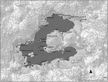
Lake Pátzcuaro is located in the Neo-Transversal Volcanic Belt, in central Michoacán, at an altitude of 2,043 m above sea level. In this area, five physiographical areas are clearly marked: islands, lake margins, slopes, intermountain valleys, and mountains (Toledo and Argüeta Reference Toledo, Argüeta, Toledo, Álvarez-Icaza and Ávila1992:221). This is a closed basin with a surface area of 1,525 km2 in which a lake was formed by many underground water currents and surface streams. It has an average annual volume of 81 million m3 of water (Figure 6; Maderey and Correa Reference Maderey, Correa and Correa1974:217), and an extension of approximately 100 km2 (Toledo and Argüeta Reference Toledo, Argüeta, Toledo, Álvarez-Icaza and Ávila1992:221). It belongs to an endorheic system in which the water balance is affected by rainfall, evaporation, and infiltration from the catchment area (Chacón Reference Chacón, Toledo, Álvarez-Icaza and Ávila1992:41). Underground infiltration has diminished considerably in recent years due to deforestation in the basin and the subsequent erosion of the surrounding soils. Rainfall levels have also decreased in the last decades, which may be related to global warming (Kennedy Reference Kennedy2007). This serious problem has been mentioned for Mexico as a whole, not just Michoacán (Davydova Baltiskaya Reference Davydova Beltiskaya2012).
Map of Lake Pátzcuaro as it was in the sixteenth century with the modern towns superimposed. The surface of the lake has diminished considerably in recent decades. Base map taken from Gorenstein and Pollard (Reference Gorenstein and Pollard1983:Map 2).

Lake Pátzcuaro is not very deep; in 1941 its depth was 15.24 m in the northern area, but its level has fluctuated considerably in historical times (West Reference West1948:3). In 1992, maximum depths of eight and 12 m were reported (Toledo and Argüeta Reference Toledo, Argüeta, Toledo, Álvarez-Icaza and Ávila1992:221). The Lake Pátzcuaro Basin has a cold-land climate (CBW), with a vegetable cover consisting of oak and other broadleaf trees, such as madroño (Arbutus sp.) and jaboncillo (Sapindaceae), among others, which predominate in a three-km radius around the lake (Table 1). Other common plants in the lakeside area are colorín (Erythrina americana), casahuate (Ipomoea murucoides), and white zapote (Casimiroa edulis). On the lake margins there are hydrophilic plants such as willows (Salix bonplandiana), tepozán bushes (Buddelia spp.), and patches of carrizo reeds (Arundo donax). Swampy areas are characterized by tule (cattails) brakes (Cyperus thrysiflorus, Typha latifolia, and T. dominguensis), while other aquatic plants include several species of water lily (Nymphaea spp.). Low-lying slopes around the lake may once have been covered by mixed pine-oak forests, but pines disappeared long ago because they were cut down for fuel and timber (West Reference West1948).
Natural vegetation of the Lake Pátzcuaro Basin (Alcocer and Bernal-Brooks Reference Alcocer and Bernal-Brooks2010; Caballero and Mapes Reference Caballero and Mapes1985, Caballero et al. Reference Caballero, Barrera, Mapes, Toledo, Álvarez-Icaza and Ávila1992; Gorenstein and Pollard Reference Gorenstein and Pollard1983; Lot and Novelo Reference Lot and Novelo1988; Reyes Reference Reyes, Toledo, Álvarez-Icaza and Ávila1992; Suárez Reference Suárez1990).

Forests in the Lake Pátzcuaro Basin consist of several species of oak (Quercus spp.), pine (Pinus spp.), and oyamel (Abies religiosa), with a pronounced presence of herbs and bushes. Agricultural lands are located on the lake's margins and nearby slopes, and make up roughly 40 percent of the basin's landscape. Although the communities in this area are primarily agricultural, household subsistence and reproduction also depend on activities such as plant gathering, forest exploitation, fishing, hunting, cattle raising, and artisanal production, among others (Toledo and Argüeta Reference Toledo, Argüeta, Toledo, Álvarez-Icaza and Ávila1992). According to Toledo and Argüeta (Reference Toledo, Argüeta, Toledo, Álvarez-Icaza and Ávila1992), the indigenous communities have known how to skilfully utilize the resources found on the land and in aquatic habitats. This is expressed in 13 agricultural systems, nine types of fishing, eight craft activities, small-scale cattle raising, as well as in a detailed knowledge of species (more than 400 named plants, 140 animals, and 53 mushrooms), the kinds of vegetation, and classes of soils (Toledo Reference Toledo, Toledo, Álvarez-Icaza and Ávila1992; Toledo and Argüeta Reference Toledo, Argüeta, Toledo, Álvarez-Icaza and Ávila1992:233–234).
According to Toledo et al. (Reference Toledo, Caballero, Mapes, Barrera, Argüeta and Núñez1980), some 250 plant species have been recorded in the Lake Pátzcuaro Basin (trees, bushes, herbs, and epiphytes), in both the forests and grasslands. They have many uses, including medicinal (99), alimentary (30), household (20), fuel (16), ornamental (12), fodder (nine), aromatic (seven), house construction (seven), resin (six), work tools (four), tanning (four), toys (four), poisons (three), insecticides (two), and magical-religious (seven; Toledo et al. Reference Toledo, Caballero, Mapes, Barrera, Argüeta and Núñez1980:32).
The Lake Pátzcuaro Basin is an area with remarkable ecological diversity, despite its apparent homogeneity. This relatively small space contains a great variety of natural plant communities, complemented by numerous species introduced by humans. The result is a particularly intricate space where it is difficult to distinguish the original vegetation and the degree of anthropogenic factors in its distribution (Caballero et al. Reference Caballero, Barrera, Mapes, Toledo, Álvarez-Icaza and Ávila1992:71).
From ancient times, the basic activities in this lake were fishing and agriculture. Nowadays, because of the lower water level, the abundant invasive aquatic vegetation, excessive fishing, and the introduction of exotic fish species, some fishers have had to change their activity and now participate in craft production and agriculture, while others have opted to exchange their traditional fishing gear for more modern equipment. As a result, at present at least five types of fishnets have fallen into disuse. All of those nets were equipped with a circular ring and wooden handle adapted for use in shallow waters, and were handled by one or two persons from small canoes (Argueta et al. Reference Argueta, Merino, Zubieta, Campos, Chávez, Rauda, Peña, Argüeta, Cuello and Lartigue1986:63).
In the 1940s, the inhabitants of towns around Lake Pátzcuaro still lived almost exclusively from fishing. The most abundant species were: pescado blanco (white fish), charal, güerepo, acúmara, corunda, tiro, lisa, and trucha (trout; Mendieta Reference Mendieta y Núñez1940). Forty years later, fishing was still a productive activity of enormous importance for the indigenous communities living on the islands and in lakeside areas. Around 1,500 fishers from some 18 communities caught 14 fish species (10 native, four introduced) in the lake, as well as an amphibian (the achoque, Batysiredon dumerilii), and some turtles and frogs (Table 2). But fishing in Lake Pátzcuaro has been undergoing profound changes because of the introduction of new species, which have decreased native fish populations. Traditional fishing, primarily for local consumption by the Indian communities, has now lost its equilibrium, while the indigenous fishing techniques that families operated in a selective way are being displaced by an indiscriminate commercial fishing industry. In recent years there has been a steep decline in fishing productivity in this lake (Toledo et al. Reference Toledo, Caballero, Mapes, Barrera, Argüeta and Núñez1980:37).
Main animal species in the Lake Pátzcuaro Basin (Alcocer and Bernal-Brooks Reference Alcocer and Bernal-Brooks2010; Argüeta Reference Argueta2008; Gorenstein and Pollard Reference Gorenstein and Pollard1983; Rojas Reference Rojas, Toledo, Álvarez-Icaza and Ávila1992).

a Species introduced in the 20th century.
Compared to Lake Cuitzeo (Williams Reference Williams2009, Reference Williams2014c) and other bodies of water in West Mexico, environmental degradation in Lake Pátzcuaro has not been as severe, though local conditions are far from ideal. A recent study found that Lake Pátzcuaro is a mature but shallow lake that is being affected by deforestation and erosion in the surrounding basin. To the widespread and excessive logging seen in the area we must add the factor of the frequent bush fires that represent an additional threat to the ecology of the basin (Bernal Brooks Reference Bernal Brooks2008).
During the Protohistoric period (ca. a.d. 1450–1530), there was a high level of interaction between the Lake Pátzcuaro Basin, the Michoacán Highlands and other areas (Pollard Reference Pollard, Smith and Berdan2003), because the basin did not possess all the natural resources necessary for subsistence. Pollard (Reference Pollard1993:113) wrote that “the basin naturally lacks salt, obsidian, chert, and lime, all products used by most households in the Protohistoric period; it also lacked a wide range of goods utilized by the elite…The core of the Tarascan state in 1520 was not a viable economic unit. It existed, even thrived, only by the exchange of goods and services in regional and supraregional patterns.” We do not yet fully understand these inter-regional relationships, however, because there has not been sufficient archaeological research in the area focused on this specific issue.
Another aspect of life in pre-Hispanic times in the Lake Pátzcuaro Basin that is not well understood has to do with the subsistence strategies, in particular the activities and material culture associated with the indigenous aquatic lifeway. This issue has been approached through ethnographic analogy, as I will further discuss.
ETHNOGRAPHIC INFORMATION ON SUBSISTENCE ACTIVITIES IN THE LAKE PÁTZCUARO BASIN
In this section, I discuss the subsistence activities—fishing, hunting, gathering, and manufacture—at Lake Pátzcuaro as discussed in several ethnographic sources, mainly from the early- to mid-twentieth century, plus the observations published by Williams (Reference Williams2014a:76–176, Reference Williams2014b:23–71).
Fishing
Of all the activities observed by the author in the field, fishing is the most productive activity and the most diverse one in terms of the associated material culture. Several different kinds of fishnet are used in Lake Pátzcuaro, including a gill net called red agallera in Spanish, and cherémekua in Tarascan (Figure 7). This net is used to catch the following fish: tiro, carpa, acúmara (also called sardina), and charal. In order for the fish to get caught in this net, the net has to be in a vertical position under the water at all times. To this end the fishers use small stones as weights that are tied to the bottom of the net. The stones are modified by making a groove with a jacksaw to prevent them from slipping and falling off the net. The cherémekua is a fixed net of variable dimensions: from 25 to 50 meters in length, a width of 60 cm to 1.5 m, and mesh openings of one, two, or 2.5 cm. The opening allows the fishers to catch selectively fish of different sizes (Rojas Reference Rojas, Toledo, Álvarez-Icaza and Ávila1992:143–144). When using the cherémekua, fishers must select the area of the lake where they want to work, since different lake depths are habitats for different species of fish. For example, for fishing charales the net has to be put in shallow waters, while the white fish or pescado blanco inhabits deeper waters. Around the 1950s, the nets for white fish were usually set up at night and the ones for charal in the morning. The period of more intense fishing activity was from February to June or July, and the gill net was not used for the rest of the year. The work unit for using the cherémekua consists of a five- to six-m long canoe, one or two oars, and a variable number of nets usually handled by a single fisher, since this is an individual activity (Rojas Reference Rojas, Toledo, Álvarez-Icaza and Ávila1992:145).
Many fishers in Lake Pátzcuaro use a gill net (called cherémekua in Tarascan), like this one from Colonia Revolución, near Erongarícuaro. Photograph by Teddy Williams.

In the early 1960s, many cherémecuas were used for fishing pescado blanco on La Pacanda Island of Lake Pátzcuaro. The nets were located in those areas of the lake where the experienced fishers knew they would obtain the best results. After a period of eight to 10 hours, the nets were lifted out of the water and the catch collected: usually between three and five specimens, but this number could increase depending on the season of the year (Aparicio Reference Aparicio1972:120). The cherémekua used by the fishers of La Pacanda came in two sizes: a small one (about one meter tall and 12–18 meters long) was used for catching the fish called kerépu near the lake shore, while a larger net (two to four meters high and up to 200 meters long) was used for fishing pescado blanco and akúmara in deeper waters (Smith Reference Smith1965).
In Ichupio, a lakeside community in the northeastern Lake Pátzcuaro Basin, Tarascan fishers used the chinchorro or seine net until recent years. The owner of the net, called patrón (i.e., master or boss), had four workers (called peones) under his command, two pulling each side of the net. The catch was usually divided into five unequal parts: one half was for the patrón, the other half was shared by the workers. According to the informants interviewed by the author in the field (2009), in the past women used to fish alongside the men, but they would not help in pulling the chinchorro with the catch out of the water. At Tareiro, however, all family members can help in dragging the net out of the water (Figure 8). The following species were caught with the seine net at Lake Pátzcuaro: charal, pescado blanco, akúmara, trucha, chegua, tiro, choromu, as well as frogs, achoques, and turtles (Williams Reference Williams2014a).
A fisher and his two daughters drag the chinchorro or seine net out of the water at Tareiro, a Tarascan community in the eastern margin of Lake Pátzcuaro. Photograph by Teddy Williams.

The chinchorro at Lake Pátzcuaro is fitted with stone weights so that it will sink to the bottom of the lake in order to catch as many fish as possible. These sinkers are usually rocks that have been modified with grooves so that they can be tied securely to the net (Figure 9). Some of these rocks may have as many as 40 years of continuous use. In some lakeside communities the fishers look for the most suitable rocks around the town and the surrounding area (Williams Reference Williams2014a).
The chinchorro or seine net used at Lake Pátzcuaro is fitted with stone weights so that it will sink to the bottom of the lake, thus catching as many fish as possible. Photograph by Teddy Williams.
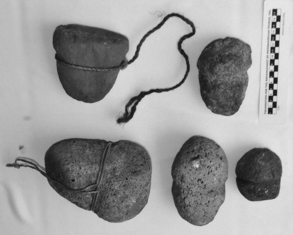
Foster (Reference Foster1948) wrote that in the 1940s fishing was a seasonal occupation at Lake Pátzcuaro, taking place primarily during the dry season (between November and May). The largest net in use here was the chinchorro, some 100–150 meters long by eight m wide, with a space of two cm between knots in the mesh. According to Aparicio (Reference Aparicio1972), in the 1960s during the season of less productivity each peón would get three or four kilos of pescado blanco in its juvenile phase (called güerepo) and charal, after a six-hour-long night shift.
In the 1980s, there were some 30 or 40 chinchorros in active use at Lake Pátzcuaro (Argueta et al. Reference Argueta, Merino, Zubieta, Campos, Chávez, Rauda, Peña, Argüeta, Cuello and Lartigue1986), and fishing was largely a male occupation, although in some cases this division of work was not strictly followed. According to Argueta et al. (Reference Argueta, Merino, Zubieta, Campos, Chávez, Rauda, Peña, Argüeta, Cuello and Lartigue1986:74), women were responsible for the commercialization of the fish, and they were also in charge of dividing the catch. The first part of the catch was for the owner of the canoe, the second part for the owner of the chinchorro, and the remaining portion was divided equally among the four peones.
Another fishing technique described for Lake Pátzcuaro is the atárakua or fisga (harpoon), used in conjunction with the umékata or trap for catching trout. This trap is usually constructed in select areas of the lake, which are not very deep, have aquatic vegetation on the surface, and are sheltered from the wind. The technique consists of cutting the vegetation in an area of one square meter, and covering the area with grass or rushes, leaving an open space to see the fishes swimming around and then kill them with the harpoon (Argueta et al. Reference Argueta, Merino, Zubieta, Campos, Chávez, Rauda, Peña, Argüeta, Cuello and Lartigue1986).
Many traditional fishing techniques have been lost at Lake Pátzcuaro, while a few persist as a mere remembrance, such as the red de mariposa or butterfly net (Figure 10), which was used to catch the fish called tiro or tiru. Tiro is virtually extinct at Lake Pátzcuaro since the 1940s, so the butterfly net is no longer used for fishing. Nowadays the net is mostly seen at the island of Janitzio, where it is admired by tourists (West Reference West1948:54).
Several traditional fishing techniques have been lost at Lake Pátzcuaro, while a few persist as a mere remembrance, such as the red de mariposa or butterfly net seen at Janitzio. Photograph by Teddy Williams.

Hunting
At present, the role of hunting as a subsistence activity has diminished considerably in the Lake Pátzcuaro Basin. Duck hunting, for instance, has disappeared almost completely from many lakeside communities, although some 40 years ago it was still a very important activity. According to Toledo et al. (Reference Toledo, Caballero, Mapes, Barrera, Argüeta and Núñez1980:36), “although the number of ducks that come each year to the lake has been steadily decreasing, duck hunting is still a distinctive activity of the Purépecha of [Lake] Pátzcuaro…every year at the end of October the kuirisi atakua or [communal] duck hunt takes place, an ancestral tradition that renews contacts and social relationships between the indigenous communities.”
In Ucazanaztacua, a Tarascan community located on the eastern margins of Lake Pátzcuaro, hunters would kill many species of birds, such as gallaretas (coot, Fulica sp.), and ducks locally known as cari, patito pico rojo, chapata, and tilano. These migrant birds would arrive at the lake in September. One of my informants in Ucazanaztacua told me that “there used to be ducks by the millions” (sic). The same informant recalled how in Jarácuaro, an island on the southwestern side of the lake, every season the fishers would hunt ducks for food. Ducks, however, “no longer come here…they used to come from the first of October, and on October 31 we went to kill birds with reeds [that is to say fisgas or harpoons] that we hurled with the tirador or tzipaki [i.e., atlatl].” The hunters would go on their canoes looking for ducks in the lake, in one trip they would bring back as many as 140 birds, which they hunted between eight o'clock in the morning and three in the afternoon. Up until 1960 wild ducks were part of the diet of the people of Jarácuaro, and they would take many ducks to sell in Pátzcuaro as well. This is a recollection of events that took place around 1945 or 1950, according to the local informants (Williams Reference Williams2014a:95–99).
On the last day of October in Janitzio, an island in Lake Pátzcuaro, hunters used the tzipaki or atlatl to bring down the ducks, which were used as an offering for the deceased as part of the festivities of the Día de Muertos, or Day of the Dead. The communal duck hunt was called feria, and many people from the lakeside communities took part in this ritual activity. One informant told the author that there were so many ducks that the water of the lake seemed to be boiling. Two or three men would go in each canoe, and they would bring back between 60 and 70 ducks. “But all that is now lost because the boatmen would pursue the ducks too hard. As many as 100 or 200 canoes would get together” for the hunt.
An informant from Arocutín told the author that “there used to be many ducks” of different species, which were killed with shotguns. “The ducks would arrive between September and October, but they do not come anymore because there is no lake left.” Before the decreasing lake area and overhunting affected the migrant bird species, there were men who specialized in hunting ducks. These hunters would hunt by night during the full moon; they had no other job during the duck season. Part of the kill was sold and part was used by the hunters as food (Williams Reference Williams2014a).
An older informant from Santa Fe de la Laguna recalled how the duck hunt was conducted many decades ago. The number of canoes that would assemble in the lake could be as high as 500, coming from all 27 lakeside communities. The hunters surrounded the ducks on the water and killed them with the fisga and tzipaki (Figure 11). Part of the ducks brought down during the communal hunt or feria would end up in a dish offered to a dead relative in the graveyard of Santa Fe and many other lakeside towns (Williams Reference Williams2014a).
The atlatl, called tzipaki in Tarascan, is an indigenous weapon used in Mesoamerica since pre-Hispanic times, like this example from Lake Pátzcuaro (ca. mid-twentieth century. Photograph courtesy of the Centro de Cooperación Regional para la Educación de Adultos en América Latina y el Caribe, Centro de Cooperación Regional para la Educación de Adultos en América Latina y el Caribe, Pátzcuaro, Michoacán.

Not all hunting performed by the Tarascans took place in the waters of Lake Pátzcuaro. In the Tarascan area, hunting traditionally took place in two different environments: one terrestrial, around the lake margins and in surrounding hills, and the other aquatic, on the surface of the many lakes and rivers of the region. Toledo et al. (Reference Toledo, Caballero, Mapes, Barrera, Argüeta and Núñez1980) tell us that, although at present hunting wildlife is virtually insignificant for the local subsistence or economy of the Lake Pátzcuaro Basin, in the surrounding mountains and lakeside areas hunting rabbits, squirrels, and doves still is a frequent activity. However, “this is really just a remembrance of the past, rather than a practice with real relevance for the economy of Purépecha communities” (Toledo et al. Reference Toledo, Caballero, Mapes, Barrera, Argüeta and Núñez1980:36).
In pre-Hispanic times hunting made a significant contribution to Tarascan nutrition and economy in the Lake Pátzcuaro Basin. Deer, rabbits, and wild fowl such as quail were hunted in the mountains, while the migrant waterfowl (ducks in particular) were hunted in the lake. One of the most important studies of the cultural geography of the Lake Pátzcuaro Basin and other areas of the Tarascan domain was conducted by West around 1946. West (Reference West1948) reported that by this period ducks were the only wild species with any real significance in the local economy. Hunting was limited to the fishers and “a few ranchers” (mostly men), who recognized nine varieties of migratory ducks, pertaining mainly to the following genera: Nyroca, Mareca, and Nettion. The hunt would start around the end of October and the beginning of November, as stated above, and would last until the ducks left the lake around the end of March. West (Reference West1948) holds that as many as 100 ducks could be killed by a single hunter using the patámu or fisga (a 3-m long harpoon made of reed with metal prongs; Figure 12) and the titador or tzipaki. The ducks were an important food source for the lakeside towns during that period (West Reference West1948:51).
Ducks were hunted at Lake Pátzcuaro with the patámu or fisga, a harpoon made of carrizo reed with three metal prongs (this item is from Tareiro). Photograph by Teddy Williams.

According to Argueta (Reference Argueta2008), a large number of people from the islands and the southern margins of the lake used to eat duck meat regularly during the hunting season. One of the most common dishes was wild duck in mole, while fried duck innards in red chili sauce were regarded as a luxury. Apart from the migrant ducks there were several resident species of ducks, as well as other aquatic birds and quail, which also were part of the diet, especially in winter (Argueta Reference Argueta2008).
Foster (Reference Foster1948) wrote that in the middle of the twentieth century the Tarascans of the Lake Pátzcuaro Basin used different kinds of traps to catch animals in the mountains. Foster wrote that hunting at Tzintuntzan, one of the most important of the lakeside towns, was a complement of fishing, because most of the hunting was performed by the fishers, since it was an activity virtually restricted to the aquatic habitat of the lake.
Apart from ducks and other water fowl, both migrant and native species, hunters in the Lake Pátzcuaro Basin used to kill many wild animals, especially in the hills around the lake. In Ihuatzio, for instance, rifles were used to bring down rabbits, squirrels, and tlacuaches or opossums (Didelphis marsupialis). In the words of an informant in Ucazanaztacua, “deer were abundant, but their numbers decreased when the road was built.” The same informant recalled that in the past in addition to fishers, there were specialized hunters called tiradores, who would bring to the town rabbits, coyotes, squirrels, deer, and snakes. Some 75 years ago there were hunters in the hills around Ucazanaztacua who came from Tzintzuntzan; they hunted rabbits, armadillos, deer, tlacuaches, and snakes with firearms (Williams Reference Williams2014a).
Menawhile, around the town of Arocutín there were many deer in the hills. When the locals planted their fields with maize, beans, or broad beans, the deer would come to feed in the fields and were killed by the farmers. Similar stories about hunting deer and other wildlife in the hills were reported by informants from other Tarascan towns in the Lake Pátzcuaro Basin, such as Erongarícuaro, Oponguio, and San Andrés. In the latter town there were many huilotas (mourning dove, Zenaida macroura), but they are less often seen today in the area (Williams Reference Williams2014a).
Argueta (Reference Argueta2008:130) described the traditional weapons used by Tarascan hunters in the Lake Pátzcuaro Basin: (1) the pitakua, a wooden spear or stick of about one meter in length; (2) the honda, or sling made of maguey (ixtle) fiber, used to hurl stones; (3) the atlatl, also known as tirador or tzipaki, for hunting aquatic fowl; (4) the patamu or fisga, a harpoon made of reed; and, (5) the bow and arrow. In addition to these weapons, hunters would catch prey such as ducks and huilotas with cotton or ixtle nets, while pit traps were used for catching small mammals in the hills.
Gathering
Gathering wild plants is still an important subsistence activity in the Lake Pátzcuaro Basin. Many requirements of food, health, and energy are fulfilled by the Tarascans of Lake Pátzcuaro by directly exploiting their natural environment. Among the principal gathered products are flowers, fruits, seeds, leaves, branches of trees or bushes, roots, and whole plants. These are used as food, condiment, for their aroma, or as colorants, fodder, and medicine, among other uses. Many of these species are seasonal, for instance some mushrooms are gathered in the rainy season, while fruits like the blackberry are obtained during the dry season. Another important product that is gathered by the Tarascans is the honey of wild bees, which is a very valued commodity, for daily use and for certain feasts (Toledo et al. Reference Toledo, Caballero, Mapes, Barrera, Argüeta and Núñez1980:39).
According to the study of plant use among the Tarascans of Lake Pátzcuaro conducted by Caballero and Mapes in the early 1980s, the list of vascular plants includes 224 species (both native and naturalized), of which 60 are gathered frequently and are used for food, fuel, or medicine. Plant gathering is usually carried out in conjunction with agriculture, so it is mostly men who perform this activity, although women take part as well (Caballero and Mapes Reference Caballero and Mapes1985). According to Caballero and Mapes (Reference Caballero and Mapes1985), certain wild fruits and roots are eaten in the field as snacks, sweets, or to alleviate thirst. These include the root of the jícama or Mexican turnip (Phaseolus heterophyllus) and the papa cimarrona or wild potato (Solanum cardiophylum). Generally speaking, wild edible plants are a basic complement of the diet, although most of the daily nutrition comes from agriculture (maize, beans, pumpkin, and wheat, among others). Wild mushrooms are an important component of the diet, but only during the rainy season. As many as 43 species of edible mushrooms are known in the Lake Pátzcuaro Basin, but only 10 are gathered regularly (Table 1).
Among the most important food plants gathered in the area under discussion are wild herbs known as quelites (Chenopodium spp. and Amaranthus spp.). There are nine quelite species, known as xakua in Tarascan. Usually they are cooked with chili and mixed with fish, meat, or beans. There are many plants that provide sweets or condiments, such as the young stalks of Agave inaequidens, which are gathered in January and are cooked and eaten as dessert. The following fruits of arboreal species are frequently gathered by the Tarascans: tejocote (Crataegus pubescens), baya or berry (Morus microphylla), tuna or prickly pear (Opuntia spp.), capulín (Prunus serotina capulli), talayote (Gonolobus numularis), and, zarzamora or blackberry (Rubus adenotrichus; Caballero and Mapes Reference Caballero and Mapes1985).
In the Lake Pátzcuaro Basin and its environs there is an enormous quantity and variety of wild plants that are gathered seasonally. Most food species are found in the rainy season, between July and September. The Tarascans say about plant foods that “they are so plentiful that many go to waste” in the wet season. Edible plants are seldom stored, unlike medicinal species which are found year-round and can be dried for later use (Caballero and Mapes Reference Caballero and Mapes1985). When wild species are combined with domesticated crops like maize, beans, tomato, pumpkin, and chili, complete and balanced nutrition is achieved. In fact, it has been said that “Purépecha cuisine is wonderfully adapted to the different wild resources available throughout the year” (Caballero and Mapes Reference Caballero and Mapes1985:40).
The wild plants that are gathered in the Lake Pátzcuaro Basin are not limited to edible species. From ancient times until the present, one of the most useful plants for the Tarascans is the rush locally known as tule or chuspata (Typha latifolia and T. dominguensis) and tule redondo (Scripus californicus and S. valuis). These rushes (Figure 13) are used to make mats called petates (Figure 14), baskets, fans, hats, sacks, and an endless list of products that were indispensable for daily life in virtually the whole of Mexico. These items today are seen as mere “handicrafts” and sometimes have a different role, such as decoration. These plants are still a fundamental part of native culture in the lake area, although their uses have diminished through time as they were replaced by metal, plastic, and other “modern” materials. The petate is still used in many Indian communities throughout Michoacán as bed and carpet, and also for packaging maize, beans, wheat, and other goods for storage.
The plant locally known as tule or chuspata is one of the most useful plants for the Tarascans of Lake Pátzcuaro. Here a tule gatherer is bringing a bundle of green stalks that will be laid down to dry on the ground at La Ortiga, near Erongarícuaro. Photograph by Teddy Williams.

Tule stalks are used to make mats called petates, as shown by this Tarascan artisan in Ihuatzio. Photograph by Teddy Williams.

Most of the artisans interviewed by the author in the Lake Pátzcuaro Basin were simultaneoously tuleros (i.e., tule workers) and fishermen. They used the money obtained from both activities to provide for their families. The women were in charge of selling the tule, and it could also be exchanged for other products, such as salt, soap, chili, tomato, and many other commodities. Tule, however, is becoming scarce around Lake Pátzcuaro, because of environmental degradation and desiccation, so the tuleros have to buy this plant from people who come from Lake Cuitzeo. Aquatic plants such as tule and chuspata are regarded as property of each community. People from other towns had to buy rushes from the local owners, since they were not allowed to cut the plants themselves (Williams Reference Williams2014a).
In addition to tule, the stalks of the carrizo reed (Arundo donax, Cyperus sp.) are an important component of the domestic economy at the Lake Pátzcuaro Basin (Williams Reference Williams2014a), as well as Lake Cuitzeo (Williams Reference Williams2009, Reference Williams2014c). Carrizo is used for making baskets of many sizes and shapes, with many different functions. This plant was also used for building material in houses, fences, and even furniture. We know that carrizo was used in pre-Hispanic times; Pollard (Reference Pollard, Williams, Weigand, Mestas and Grove2005) excavated remains of wattle-and-daub house walls in Urichu, pertaining to the Classic period.
Manufacture
In this section, I discuss several traditional activities connected with the manufacture of numerous objects that have long been indispensable for subsistence in the context of the Tarascan aquatic lifeway. We saw in previous sections that weaving tule mats or petates is important for the domestic economy within Tarascan communities, especially in areas like the Lake Pátzcuaro Basin. The production techniques observed during fieldwork are described in detail by Williams (Reference Williams2014a); here I present a summary discussion. After cutting the tule stalks they are dried under the sun, and later they are sprinkled with water so that the plant fibers recover their original elasticity. Only two tools are needed for weaving a petate: a hand stone called piedra petatera (seven to 10 centimeters in diameter and three to four centimeters in thickness) used as a hammer for flattening the interwoven tule fibers (Figure 15), and a steel knife to make an even edge by cutting off the excess tule stalks sticking out from the mat's woven borders.
The handstone called piedra petatera is used as a hammer for flattening the interwoven tule fibers of the petate (Ihuatzio). Photograph by Teddy Williams.

Petates are not the only items made with tule or chuspata in the Lake Pátzcuaro Basin. In Ihuatzio, for instance, baskets called papeleros (waste-paper baskets; Figure 16) are made in a domestic workshop visited by the author. Making these baskets involves the following steps: (1) the tule stalks are trimmed with a steel knife according to the desired length; (2) the stalks are placed on a cylindrical wooden base (Figure 17); (3) a steel bucket is used as a mold to give the papelero its final shape; and (4) the excess fibers are trimmed from the basket's rim with a knife (Figure 18).
This basket made of tule or chuspata, called papelero (waste-paper basket), was made in a domestic workshop at Ihuatzio. Photograph by Teddy Williams.

Making a papelero basket. The artisan is using a wooden base and the petatera stone (Ihuatzio) Photograph by Teddy Williams.

After the papelero is woven, the excess fibers are trimmed from the basket's rim using a steel knife (Ihuatzio). Photograph by Teddy Williams.

As I mentioned earlier, items made of carrizo reeds are as important as those made of tule in the domestic economy of many Tarascan households in the Lake Pátzcuaro Basin, although at present few people are dedicated to working carrizo as a full-time activity. In a domestic workshop in Ihuatzio, the process of manufacture of a carrizo basket starts by harvesting the stalks from the lake shore (see discussion in Williams [Reference Williams2014a:145–148]). Once the carrizo is in the workshop, the artisan peels off the outer skin of the stalk and cuts it lengthwise (Figure 19); after this the bottom of the basket is woven on a stone slab supported on a wooden stool (Figure 20), then the sides and handle of the basket are finished. The assemblage used for making baskets includes several cutting implements, such as steel knives and a hacksaw (Figure 21), as well as stones used as “hammer” and “anvil.” In many instances the artisans told us that the stones they used formerly belonged to their fathers or grandfathers, and may have as many as three generations in continuous use.
This artisan is trimming the carrizo stalks for making baskets in a domestic workshop at Ihuatzio. Photograph by Teddy Williams.

This stone slab and wooden support are used for making baskets in the workshop shown in Figure 19. Photograph by Teddy Williams.

The tool assemblage used for basket making includes several cutting implements, such as metal knives and hacksaws (Ihuatzio). Photograph by Teddy Williams.

One of the most important crafts in the Lake Pátzcuaro Basin was knitting fishnets, which were an essential component of the fishers’ trade. In Tzintzuntzan, for example, most fishers used to knit their own nets. Some of them were particularly skillful and would spend more time than the rest in this occupation. Until the late 1940s or so, maguey or ixtle fiber was used for making nets, but by 1948 cotton thread had been introduced. In Ichupio the malacate or spindle whorl was still used in the late 1940s for spinning the thread used by the net makers, but it was eventually replaced by the spinning wheel (Foster Reference Foster1948:107).
In the Lake Pátzcuaro area each fisher will usually knit his own fishnet (Figure 22), using a special needle called aguja plana or “flat needle” (pikukua or churukua in Tarascan; Figure 23). In most villages around the lake, fishnets were made by men, women, and children during their free time. In Janitzio and several islands in the lake, in the 1940s there were a few rederos or full-time fishnet makers who would sell the nets directly to the fishers from the towns around the lake. The nets were knitted with a wooden churukua 20 cm long by two cm wide (West Reference West1948:66). The use of maguey fibers for knitting fishnets is probably a custom that goes back to pre-Hispanic times. In the Lake Pátzcuaro Basin the production of maguey fibers was very important until the mid-twentieth century. According to Brand (Reference Brand1951), in Quiroga and surrounding hamlets there were people who occasionally made ropes and bags or sacks with maguey or yucca (Yucca spp.) fiber, which was obtained in the vicinity.
Each fisher usually knits his own fishnet in the Lake Pátzcuaro Basin, like this one at Urichu. Photograph by Teddy Williams.

The aguja plana or “flat needle” (pikukua or churukua in Tarascan), is used for weaving fishnets at Lake Pátzcuaro (Urichu) Photograph by Teddy Williams.

One of the most important components of the Mesoamerican aquatic lifeway was the canoe, widely used as a means of transportation as well as for fishing and other subsistence activities. Until the late 1950s or so, in Michoacán the canoes were made of hollowed-out tree trunks (pine or pinabete, common fir). There were specialized canoe makers in the Tarascan Sierra, who took advantage of the extensive forests there. The canoes used by the Tarascans of the lake were of several types: the icharuta (Figure 24) was a small canoe (approximately 2.5–6 meters long) used for fishing and hunting, while the tepari (Figure 25) was a larger vessel (approximately 10–12 meters long), used for transporting people and goods across the lake. The canoe makers used steel axes to cut down the trees and adzes to hollow out the canoe. The canoes were brought down from the sierra to the lake pulled by oxen (Foster Reference Foster1948). In pre-Hispanic times canoe manufacture would involve more strenuous work, because of the lack of metal tools. Likewise, the transportation of the finished canoes would have depended on human porters.
The canoe called icharuta is used by the Tarascans of Lake Pátzcuaro for fishing and hunting (ca. mid-twentieth century). Photograph courtesy of Centro de Cooperación Regional para la Educación de Adultos en América Latina y el Caribe, Pátzcuaro, Michoacán.

The tepari is a large canoe used for transporting people and goods across Lake Pátzcuaro (ca. mid-twentieth century). Photograph courtesy of Centro de Cooperación Regional para la Educación de Adultos en América Latina y el Caribe, Pátzcuaro, Michoacán.

DISCUSSION AND CONCLUSIONS
Here I present a summary discussion of the archaeological markers, i.e., the artifacts and features associated with subsistence activities in systemic or ethnographic context, and their role in the interpretation of the pre-Hispanic assemblages and cultural landscapes of the ancient Tarascans. This reconstruction is based on the ethnohistorical and ethnographic information discussed above.
I have mentioned numerous diagnostic artifacts and features in systemic or ethnographic context that can aid in the interpretation of the archaeological record by means of analogy. Ethnographic and ethnohistorical data help us in the reconstruction of the assemblage of material culture associated with the four main clusters of subsistence activities within an aquatic lifeway: fishing, hunting, gathering, and manufacture (Table 3).
Subsistence activities in the Lake Pátzcuaro Basin and their archaeological correlates.

Fishing
This is the activity with greatest archaeological visibility in the study area, although not all fishing techniques would have the same probability of being preserved in the archaeological record. Fish traps made of carrizo, for instance, would probably not be encountered in an archaeological excavation. The gill net or cherémekua was probably made of ixtle fiber, which would also disappear with the passage of time. But the small stones or other objects, such as worked potsherds used as weights for the gill net, would persist in the archaeological record. Recent archaeological research in the Lake tzcuaro Basin has discovered modified potsherds with a round shape and two notches (Phillips Reference Phillips2002). These artifacts have been identified as fishnet weights. Similar objects have been reported from Lake Texcoco, in the Basin of Mexico (Parsons Reference Parsons2006:Figure 7.13). We found numerous artifacts of this kind on the ground surface around the towns of Jarácuaro (Figure 26a) and Ucazanaztacua, on the margins of Lake Pátzcuaro (Figure 26b).
These modified potsherds may have been used as fishnet sinkers in pre-Hispanic times at (a) Ucazanaztacua and (b) Jarácuaro, in the Lake Pátzcuaro Basin. Photographs by Teddy Williams.

The fishers at Lake Cuitzeo currently use fragments of roof tiles made of clay tied to the bottom of the gill net in order to make it more effective. In some lakeside towns, one can see on the ground many modified pre-Hispanic potsherds that may have been used with the same purpose in ancient times (Williams Reference Williams2014c:Figure 15).
Bond (Reference Bond1971) excavated several archaeological sites in the Lake Chapala Basin; she reported a tool assemblage including many artifacts that may have been part of the survival strategies around Lake Chapala, such as fishing. This activity is suggested by small spherical, grooved, clay objects that may have been used as fishnet sinkers in pre-Hispanic times, similar to the small stone weights attached to the cherémekua at Lake Pátzcuaro (Figure 27).
The fishers at Lake Pátzcuaro use small stones as weights for the cherémekua or gill net, like these items found at Colonia Revolución, near Erongarícuaro. Photograph by Teddy Williams.

The chinchorro or seine net, because of its size, requires larger and heavier weights than the chemérekua, so the fishers in the Lake Pátzcuaro Basin use large rocks tied to the bottom of the chinchorro. Pollard (Helen Pollard, personal communication 2012) has found similar large, worked stones in her archaeological excavations around Lake Pátzcuaro.
Another item associated with fishing activities is the canoe. Few canoes have been preserved from pre-Hispanic times to the present (Favila Reference Favila2019), so we have to look for indirect information to identify this aspect of aquatic subsistence, such as the large stones used as anchors in some canoes at Lake Pátzcuaro, which are much larger than the chinchorro stone weights (Figure 28). Similar stones were found by Willey (Reference Willey1972) at Altar de Sacrificios, Guatemala, and he tentatively identified them as anchors used in ancient Maya canoes. Likewise, stone anchors have been reported from Pyramid Lake, in west-central Nevada (Tuohy Reference Tuohy, Janetski and Madsen1990:Figure 16), together with large stones that may have functioned as fishnet weights (Tuohy Reference Tuohy, Janetski and Madsen1990:Figures 17–20).
A large modified rock is used as an anchor in a canoe at Lake Pátzcuaro (Janitzio). Photograph by Teddy Williams.

Hunting
Several weapons used by hunters in the Lake Pátzcuaro Basin, such as fisgas and arrows, would be represented in the archaeological record by the points made of obsidian, chert, or similar stones, like the projectile points found at Lake Zacapu (Arnauld et al. Reference Arnauld, Carot and Fauvet-Berthelot1993) and Lake Texcoco (Parsons and Morett Reference Parsons, Morett and Williams2005). As mentioned above, the atlatl or tzipaki was used for hunting ducks and other game at Lake Pátzcuaro until recent decades. Although the atlatl is usually made of wood, and it would not be preserved in the archaeological record, in ancient times the atlatl had two grips or rings made of shell, which have been found in aquatic environments such as Lake Sayula, Jalisco (Figure 29; Blanco Reference Blanco2007). Pre-Hispanic atlatl rings have been found at many sites throughout West Mexico (Suárez Reference Suárez1981; Cabrero Reference Cabrero and Williams2004; Goldstein and Suárez Reference Goldstein and Suárez1997; Pollard and Cahue Reference Pollard and Cahue1999).
These atlatl grips made of shell were found in the Lake Sayula Basin, Jalisco. Photograph courtesy of Ericka Blanco.

Stirling made important observations about the tzipaki while it was still used by most hunters in Lake Pátzcuaro, in the middle of the twentieth century. Stirling (Reference Stirling1960) affirms that the atlatl had been used throughout the New World, and in fact was the major weapon in the aboriginal arsenal, much earlier than the bow and arrow. According to Stirling, after the Conquest the atlatl would no longer be used as a weapon for war, but persisted until the twentieth century as a hunting implement among indigenous groups such as the Nahuas of Xochimilco, in the Basin of Mexico, and the Tarascans of Lake Pátzcuaro. Stirling also tells us that tzipakis were made by a few specialists in the island of Janitzio, who would sell them directly to the fishers throughout Lake Pátzcuaro. Williams (Reference Williams2014a:171–173) presents a detailed discussion of how the atlatl was manufactured by Tarascan artisans in recent times.
Gathering
Although the historical and ethnographic accounts discussed in previous pages leave no doubt about the importance of gathering wild resources in the Tarascan area, there are very few archaeological markers linked with the exploitation of wild species, such as the enormous amounts of plants that were used for food, medicine, handcrafts, construction, fuel, and other purposes. Likewise, the insect species that were gathered at Lake Pátzcuaro and other parts of the Tarascan area, such as the Meseta Tarasca (Argueta Reference Argueta2008) and the Lake Cuitzeo Basin (Williams Reference Williams2009, Reference Williams2014c), had a critical role in the native diet and economy, but usually left no (or very few) archaeological traces (see discussion in Williams [Reference Williams2014a:106–125]). Ethnohistorical and ethnographic information from other areas of Mesoamerica is very important to shed light on gathering activities, and their role in the indigenous economy.
Although lake products such as small insects, larvae, and worms would not be very appealing to a modern Western palate, we know that in ancient times this type of food was consumed with relish in many parts of Mesoamerica (Castelló Reference Castelló1987; Parsons Reference Parsons, Williams, Sánchez, Weigand and Gándara2011, Reference Parsons2019). Orozco y Berra (Reference Orozco y Berra1978 [1880]) reported in the nineteenth century that the Indians of the Basin of Mexico used to gather an insect called axayacatl that was used for birdfeed. According to this author, in pre-Hispanic times great quantities of axayacatl were caught in the lakes of that basin. These tiny insects were used to make a paste which was then wrapped in maize leaves and boiled to make a kind of “bread,” a dish that was not disagreeable to the Spaniards who sampled it after the Conquest (Orozco y Berra Reference Orozco y Berra1978[1880]:265; see also Parsons [Reference Parsons2006] and Sahagún [Reference Sahagún, Dibble and Anderson2012]).
The pre-Hispanic inhabitants of the Basin of Mexico also ate axayacatl eggs, known as ahuautli, which according to Orozco y Berra tasted like caviar. Finally, the larva of this insect, either boiled in maize leaves or ground to a paste, was known as puxi and was reputed to be highly nutritious (Orozco y Berra Reference Orozco y Berra1978[1880]:265). It is not known whether the early inhabitants of the Lake Pátzcuaro Basin used insects as food, but we do know that several species of aquatic insects, their larvae, and mud worms were likely available to them. Several insect species are currently obtained at Lake Cuitzeo, such as the mosco de agua or nizpo (probably Corisella texcocana or Ephydra sp.), which ends up as bird or fish feed in many pet shops outside of the lake area (Williams Reference Williams2014a:123–125).
Many other insects were also used as food in diverse areas of Mesoamerica, apart from those mentioned above. These species included the aquatic fly (amoyotl in Nahuatl), the larvae of the gusano lagunero (lake worm, Nahuatl izcahuitl), the grasshopper, the jumil, the chinche de monte (mountain bug, Nahuatl xotlimilli), and an enormous variety of locusts, larvae, caterpillars, ants and wasps, etcetera (Castelló Reference Castelló1987; Rojas Reference Rojas1998; Sahagún Reference Sahagún, Dibble and Anderson2012).
Plant processing used for food manufacture could be identified in the archaeological record by the grinding tools probably used for maize preparation, such as the metates reported by Manzanilla (Reference Manzanilla, Manzanilla and Chapdelaine2009) from Teotihuacan, on which she found the remains of maize phytoliths.
Pottery vessels used for brewing, boiling, storing and serving foods (liquids and solids) can be identified by trace analysis (see discussion in Williams [Reference Williams2017:ch. IV, pp. 132–138]).
Manufacture
The people who go into the lake to harvest the reeds (carrizo) and rushes (tule) in Lake Pátzcuaro use machetes or sickles (Figure 30) for harvesting the plants and knives for trimming the stalks. Knives, hacksaws, and other cutting tools are used in the manufacture process. In ancient times obsidian tools could have been used for this activity, like the blades, points, scrapers, and other tools found at Lake Zacapu by Arnauld et al. (Reference Arnauld, Carot and Fauvet-Berthelot1993; usewear analysis could help to establish the tool's function, as shown by Clark [Reference Clark1988], Barton [Reference Barton1998], and Shea [Reference Shea2016]), or the saw-toothed chert tools from Lake Texcoco reported by Parsons and Morett (Reference Parsons, Morett and Williams2005). The evidence of petate or mat weaving would consist of the piedra petatera or hand stone mentioned above, as well as small cutting tools (probably obsidian, chert, or some similar rock; Figure 31), while basket makers had to process the carrizo stalks with the anvil and hammer stones in order to make them flat and pliable (Figure 32).
At Lake Pátzcuaro sickles are used for harvesting reeds (carrizo) and rushes (tule or chuspata), and knives are used for working with these plants in the domestic workshops. Photograph by Teddy Williams.

The archaeological evidence of petate weaving would consist of the piedra petatera or hand stone, as well as small cutting tools, like these examples from Ihuatzio. Photograph by Teddy Williams.

The anvil and hammer stones are used by carrizo basket makers for pounding the stalks in order to make them flat and pliable (Ihuatzio). Photograph by Teddy Williams.

Fishnets, bags, and other items made of woven fibers such as cotton and ixtle are usually not preserved in the archaeological record, so archaeologists have to look for secondary information to identify these materials and the manufacturing activities. We saw earlier that the Lake Pátzcuaro fishers usually make their own fishnets, using a needle that could remain in the archaeological record if made of durable materials such as bone or shell, like the examples from Lake Cuitzeo discussed by Williams (Reference Williams2014c:Figure 14).
There is another archaeological marker that would suggest the manufacture of fishnets in pre-Hispanic times. According to the ethnographic accounts discussed above, fishnet making was an important activity in lakeside towns, and ixtle fiber was preferred because of its strength and durability. Parsons (Reference Parsons and Williams2005) conducted an ethnoarchaeological investigation of ixtle fiber production in the Valle del Mezquital, Hidalgo. She found that the spindle whorls used in ixtle fiber manufacture are larger than the ones used for finer thread, like cotton. Pollard (Reference Pollard, Williams and Maldonado2016), meanwhile, found a collection of spindle whorls in her excavations at Urichu, including a large-sized item that could have been used for spinning ixtle thread for making fishnets, ropes, sacks, and other coarse-fiber objects probably associated with fishing and other aquatic activities.
I have discussed here the unique character of the aquatic lifeway in Mesoamerica, and the critical role of aquatic landscapes for Michoacán, among many areas of the Mesoamerican ecumene. After the Spanish conquest, Mexico experienced 500 years of change and the original landscapes are barely recognizable in present-day Michoacán. Likewise, the Mesoamerican aquatic lifeway has been lost in all but a handful of regions in Mexico. Parsons (Reference Parsons2006) mentions a “Western bias” that in his opinion has impeded many people from understanding and appreciating the true nature of Mesoamerican subsistence, in particular the pre-Hispanic foodways. Parsons holds that relatively few scholars have been able to completely understand “the role of aquatic resources in the traditional economies of Middle America and, especially, in the most highly urbanized areas of Mesoamerica. Western scholars…saw that aquatic resources were of secondary, or even tertiary, importance in the ancient Old World civilizations most familiar to them, all of which had a major pastoral component” (Parsons Reference Parsons2006:3). This attitude was particularly noticeable in the case of “all aquatic flora and…all aquatic fauna apart from waterfowl and fish. Edible resources like algae and aquatic insects, with enormous productive and nutritional potential, were simply dismissed as irrelevant, or ignored altogether…Such reasoning seems unsound when applied to ancient Mesoamerica, where a pastoral component was absent” (Parsons Reference Parsons2006:3).
As Parsons (Reference Parsons2006:3)points out, in part this neglect of aquatic landscapes and resources “derives from an inherent and deeply embedded bias in Western culture against marshes and swamps as places full of disease, foul odors, pestilence, and sinister forces. In modern times such prejudice has taken the form of concerted efforts to drain wetlands and convert them into agricultural land” in spite of all the “abundant historic documentation of the great variety and nutritional value of the traditional pre-Hispanic diet in the Valley of Mexico, with particular attention to nonagricultural aquatic resources.”
In the case of Colonial Mexico, factors such as the demographic collapse of the native population due to pandemic diseases and the introduction of cattle, sheep, and goats meant that the aquatic landscapes and lifeways were virtually destroyed by deforestation and the elimination of wetlands, which were gradually modified into land for capitalist agriculture and cattle raising (Melville Reference Melville1994). We see an example of this situation in Michoacán, where one of the most important aquatic environments, the Lake Zacapu Basin, was drained and converted to agriculture in the early twentieth century (Reyes Reference Reyes1998).
The aquatic lifeway was a broad-spectrum strategy, in which the fishers, hunters, gatherers, and artisans—whether specialists or individuals following a “multi-crafting” approach—relied mostly on perishable materials (fishnets, traps, baskets, reed mats, canoes, and so on) that left few traces in the archaeological record. This confronts archaeologists with a challenge, which can be solved by means of observations made in the ethnographic or systemic context and the resulting hypotheses about subsistence activities and their material correlates (Binford Reference Binford1983; Schiffer Reference Schiffer1995). The manufacture of handcrafts has been of primary interest for sociocultural anthropologists and archaeologists for a long time, although it is difficult to establish the degree of artisan specialization at the settlement or household level in ancient Mesoamerica (Feinman and Nicholas Reference Feinman, Nicholas and Shimada2007; Hirth Reference Hirth, Manzanilla and Hirth2011, Reference Hirth2016). The study of manufacturing activities from an ethnoarchaeological perspective can aid us in the identification by analogy of the assemblages and the archaeological markers, that is to say the material culture and the elements, features, and settings of production in archaeological contexts. The processes of production can also be discerned through the lens of ethnohistory (Williams Reference Williams2009, Reference Williams2014a, Reference Williams2017:ch. II).
The goal of my study of aquatic activities in Michoacán is to provide ethnographic models for archaeological interpretation. Archaeology is the only social science where one cannot observe directly the object of study: the cultural behavior in the distant past. In order to arrive at a plausible interpretation of the archaeological record, we should bear in mind the various terms found in the archaeological literature, such as “bridging arguments” (Wylie Reference Wylie2002); “middle-range theory” (Binford Reference Binford1983); teorías mediadoras (Bate Reference Bate1988); and “formation theory” (Shott Reference Shott1998). These terms refer to an approach in which ethnographic fieldwork helps the archaeologist to relate a cluster of activities and cultural behaviors (in this case, the aquatic lifeway) with a particular assemblage and other diagnostic features of material culture and cultural landscapes that can aid in the interpretation of the archaeological record through analogy. The critical role of the ethnoarchaeological approach is further underscored by Clark's (Reference Clark1939) dictum: “Material culture has meaning only in relation to society.”
From the descriptions discussed here of landscapes and natural resources in aquatic environments during the sixteenth century, we can tell that aquatic landscapes retained their importance from ancient times to the early Colonial period. In order to understand the subsistence strategies in the area under discussion, we need to be able to visualize not just the original landscapes, but also the tool assemblages (Table 3) that were part and parcel of the aquatic lifeway in pre-Hispanic times. This can be achieved through the study of ethnohistorical sources and ethnographic analogy, as we have seen in this article. Much remains to be done in this respect, and the time left to do it may be running out. Because of the serious environmental and social problems—deforestation, pollution, urbanization, and extreme poverty, among others—faced by people living in aquatic environments in Mexico and other countries, the current generation of scholars (and students) could be the last one able to see and record a traditional way of life that in many cases harkens back to the distant past. This work should be carried out, otherwise it would be an irreparable loss for our understanding of the ancient history of lakes, rivers, streams, and other wetlands, where fishers, hunters, artisans, and many other people made their livelihood for countless generations.
RESUMEN
Aquí se discute el papel de los recursos acuáticos en Michoacán desde ca. 1540 d.C. hasta el presente, desde la perspectiva de las fuentes históricas y la etnografía. Primero vemos el medio ambiente natural y los bienes aprovechados por las comunidades en la época posterior a la conquista española (principalmente el siglo XVI). Esta perspectiva es invaluable para analizar el papel de los recursos acuáticos dentro de la economía política del Estado tarasco prehispánico, en el contexto del modo de vida lacustre en la ecúmene mesoamericana.
Posteriormente presentamos los resultados del trabajo de campo etnoarqueológico realizado por el autor en la cuenca del Lago de Pátzcuaro en 2009. Primero discutimos los antecedentes geográficos y culturales del área de estudio, para luego pasar a mencionar la información etnográfica sobre las actividades de subsistencia: pesca, caza, recolección y manufactura. Para esto también hemos utilizado la información arqueológica y etnohistórica publicada para otras regiones del Occidente de México, así como de Mesoamérica y de Norteamérica. Estos datos presentan una imagen sobre los pescadores, cazadores y artesanos, que constituye una reminiscencia de las costumbres y prácticas culturales de la antigüedad. También hemos obtenido un modelo de analogía etnográfica para la interpretación del registro arqueológico.
La información etnográfica, arqueológica y etnohistórica discutida en este artículo nos ayuda a arrojar algo de luz sobre los procesos culturales y sus correlatos arqueológicos (artefactos, rasgos y elementos) relacionados con el modo de vida lacustre en los lagos michoacanos, en particular el de Pátzcuaro. Esta información es vital para interpretar el registro arqueológico no sólo en el área de estudio, sino también en todas las partes del Occidente y del resto de Mesoamérica donde los lagos, ríos, pantanos y arroyos permitieron a nuestros antepasados aprovechar a través de los siglos los abundantes dones de la naturaleza.
ACKNOWLEDGMENTS
The fieldwork on which this article is based was conducted at the Lake Pátzcuaro Basin in 2009. The author received support for fieldwork at Lake Pátzcuaro (2009) and Lake Cuitzeo (2004–2009) from the following institutions: Foundation for the Advancement of Mesoamerican Studies (2004), Centro de Investigaciones en Ecosistemas-UNAM (2004–2009), and the Colegio de Michoacán (2010–2019). The book La gente del agua (Williams Reference Williams2014a; out of print) is the basis for this article. This book was written while I was a Visiting Scholar at Tulane University's Anthropology Department (2011–2012). My stay at Tulane was made possible by a sabbatical grant from the Consejo Nacional de Ciencia y Tecnología. The following scholars have assisted me with suggestions and information through many years: Dan Healan, Jeffrey Parsons, Helen Pollard, and Magdalena García Sánchez. My son Teddy accompanied me in the field and took all the photographs.