There have been renewed calls over the past two decades for new comparative perspectives that tackle the large-scale nature of Spanish colonialism in the Americas as a historical process by adopting wider analytical scales to understand the complex dynamics of the period (e.g., Deagan Reference Deagan2003; Hofman and Keehnen Reference Hofman and Keehnen2019; Van Buren Reference Van Buren2010; Voss Reference Voss2008). The archaeology of mobility offers one such potentially fruitful comparative perspective (Beaudry and Parno Reference Beaudry and Parno2013), one that pushes us beyond the scales of the site and the bounded region and encourages us to look at the wider forms of connectivity that tied the Spanish colonial world together. At a fundamental level, the colonial period saw new and accelerated flows of people, materials, and ideas across unprecedented spatial scales. These new flows of people ranged in magnitude and duration from the initial events of the entradas of the fifteenth and sixteenth centuries to the longer-term processes of enslavement, forced resettlement, labor mobilization, migration, caravanning and coastal trade, and evasion (Bakewell Reference Bakewell1984; Glave Reference Glave1989; Goetz Reference Goetz2016; Restall Reference Restall2004). These human mobilities were paralleled by new flows of materials ranging from the transoceanic movement of precious metals and stones to the regional trade networks of basic commodities and finished goods (Assadourian Reference Assadourian1982; TePaske Reference TePaske2010).
A comparative archaeological approach to these flows would aim to (1) grasp both parallel and divergent histories of colonial mobilities from La Florida to Tierra del Fuego, (2) explore the impacts of preexisting Indigenous landscapes of mobility on these histories, and (3) develop an analytical framework that highlights the materially and spatially embedded nature of these mobilities. In outlining such an approach, we recognize the diversity of mobilities in the post-invasion Americas: rather than flattening these important differences by taking a single macroscale perspective, we tack across multiple scales of comparison. Furthermore, we mobilize the classic strengths of the archaeological approach—with its attention to time depth, landscape, materiality, and subaltern actors—to revisit and rethink the patterns of movement that constituted the emergent Spanish colonial world.
A wide range of methodologies have increasingly been brought to bear on the archaeology of mobility in the early Spanish colonial world. Osteological and isotopic analyses have opened new windows into mobility at the level of the individual (e.g., Laffoon et al. Reference Laffoon, Rojas and Hofman2013; Larsen et al. Reference Larsen, Griffin, Hutchinson, Noble, Norr, Pastor and Ruff2001). Other methodologies have looked to larger social and spatial scales, with analyses of material culture created by enslaved African diasporas (e.g., Smith Reference Smith and Deagan1995) and regional landscapes of forced resettlement (e.g., Wernke Reference Wernke2013) standing as key examples of archaeological insights into patterns of colonial mobility.
The following discussion focuses on the colonial route as object of investigation through an archaeological analysis of the landscapes and transport regimes associated with three of the most emblematic cases of early colonial resource extraction: the ruta de Colón on the island of Hispaniola, the routes connecting the southeastern Caribbean islands with mainland South America, and the ruta de la plata in the south-central Andes. In juxtaposing these three studies, we ask several broader questions. What were the transconquest relationships between pre-invasion Indigenous landscapes of movement and the emergent routes of the early Spanish colonial period? How did these new routes relate to shifting mobility regimes, Indigenous actors, and state projects in the formative post-entrada periods during the fifteenth and sixteenth centuries? And narrowing to the case studies examined here, how might comparative analysis help us understand the wider connections between landscape, movement, and resource extraction in the early colonial world? In answering these questions, we aim to decenter some of the traditional historical approaches—text-driven, urban-centered, and focused on “trail-blazing” entradas and dematerialized commodity flows—that continue to shape received understandings of the region and its colonial history.
Routes and Journeys
The archaeological study of routes has a rich genealogy in the Americas, with important studies in the 1980s and 1990s intersecting with the archaeology of complex societies, historical archaeology, and the landscape turn (Snead et al. Reference Snead, Erickson, Darling, Snead, Erickson and Darling2009:6–9). Hyslop's (Reference Hyslop1984) magisterial work on the Inca road system and Trombold's (Reference Trombold1991) edited volume on ancient road networks in the New World stand as two pioneering approaches to routes and their archaeological study, with a focus on the roads of preconquest complex polities. More recently, the study of preconquest routes has moved in new directions, driven both by methodological developments and new theoretical interests in mobility and networks (e.g., Carballo and Pluckhahn Reference Carballo and Pluckhahn2007; Mol Reference Mol2014; Slayton Reference Slayton2018). These developments have been paralleled in historical archaeology (particularly in the United States), with studies looking both at transport corridors over the long term as they shaped prehistoric and historic movement (e.g., Whitley and Hicks Reference Whitley and Hicks2003) and at shorter timescales to examine the materiality of historical trails and individual journeys (e.g., Wesson Reference Wesson2012).
To provide a little terminological clarity, we turn to Earle's (Reference Earle and Snead2009:255–256) distinctions between three types of routes: paths (local, daily use, little construction), trails (regional, periodic, little construction), and roads (local to long distance, daily to periodic, significant construction). Although Earle himself notes that this typology is somewhat rigid as formulated, it provides an initial basis for exploring the multiple degrees of variability in the forms and uses of past routes. The definitions also highlight the “life histories” that a route may develop involving processes such as routinization (incorporation into enduring taskscapes), formalization (investment in the built form of a route), and abandonment.
It is also worth underlining the distinction between routes and journeys. The difference is one of temporal scale, with journeys formed by the movement of individual actors over a limited period of time who may follow (or diverge from) established routes within a given landscape. The distinction is an important one, especially given the long-standing focus within historical archaeology on tracing the journeys of specific historical individuals. The archaeological investigation of journeys has its own important roots in the classical and biblical studies of the Mediterranean world, joining together the topographical approach (connecting specific landscape features to references in a textual canon) with the biographical approach (finding the material traces of specific historical figures) (Andrén Reference Andrén1998:14–21, 49–50; Hicks and Horning Reference Hicks, Horning, Hicks and Beaudry2006).
With respect to the colonial Americas, archaeological studies of journeys have similarly sought to join narrative text with landscape, with the aim of tracing the early movements and encounters of specific (usually European) individuals (e.g., Galloway Reference Galloway1997; Hofman et al. Reference Hofman, Hung, Malatesta, Sony Jean, Sonnemann and Hoogland2018). This archaeological emphasis on journeys may be contrasted with a focus on the routes that emerged over the longer timescales of colonial history: although individual journeys and emergent routes are intimately linked through their processual relationship, it is immediately apparent that the enduring routes that emerged as routinized and formalized parts of colonial landscapes did not necessarily follow the courses of the earliest journeys of the initial entradas. At its most basic, the distinction between routes and journeys may be seen in terms of a structure–event dynamic, with the event of the entrada and the structure of early colonial route networks forming two poles of this relationship.
The emergence and persistence of such routes are shaped by a broad set of factors, including transport technologies, degrees of landscape modification, and journey scheduling (Earle Reference Earle and Snead2009). Collectively these factors may be thought of as constituting transport regimes: roughly coherent modes of organizing logistics at particular scales and for specific purposes. As an example, we might consider the ethnographic case of long-distance caravanning in the south-central Andes, a practice that brings together camelid herds, bodies of pastoralist and wayfinding knowledge, intercommunity relationships, and the barter of resources including salt into an enduring transport regime (Nielsen Reference Nielsen and Kuznar2001).
In those cases where routes were closely tied into economies of resource extraction, we can also consider a parallel concept—extraction regimes—that delineates the specific configurations of extractive technologies, resource distributions, and the modes of labor organization that are built around these particular resources. Analyzing the different ways in which these multiple regimes along the production-transportation-consumption chain were articulated can give us an important foothold in tackling the questions of scale and connectivity that are central to understanding colonial mobilities and their effects. Rather than seeing extraction regimes and transport regimes as entirely distinct domains to be analyzed separately, the approach developed here seeks to examine the connections between production and logistics through a focus on the ways that landscapes of extraction and landscapes of mobility were co-produced.
Mobility and Colonial Resource Materialities
The recent discussion of resource materialities is particularly relevant for thinking through the mobility–extraction relationship. Emerging in the intersecting investigations of resource geographers, political ecologists, and anthropologists studying capitalism, the turn to resource materialities has called for an attention to the material qualities of “natural” resources as both entangled with and exceeding the domains of the political and the social (Ferry and Limbert Reference Ferry and Limbert2008, Richardson and Weszkalnys Reference Richardson and Weszkalnys2014). Mitchell's (Reference Mitchell2011) discussion of the transition from coal to oil energy regimes during the twentieth century is a telling example of the potential insights provided by an explicit focus on the material qualities of natural resources. By exploring the ways in which the specific properties and affordances of coal and oil shaped and were shaped by the infrastructures of extraction and distribution, labor organization, and broader geopolitical formations, Mitchell (Reference Mitchell2011) provides a compelling account of the entangled yet nondeterministic relationships between material resources and their politics.
Much of the recent resource materialities literature—for instance, Tsing (Reference Tsing2005) on timber in Indonesia and Rolston (Reference Rolston2013) on coal in the western United States—has tended to focus on late twentieth- and early twenty-first-century extractivism in the context of multinational ventures and commodity booms. However, several archaeological cases suggest a growing interest in studies that move beyond the ethnographic present to consider the deeper histories of “natural resources” and “social power” coming into productive friction. Johansen and Bauer (Reference Johansen and Bauer2018) have explored the ways in which water and iron ore emerged as powerful resources at a regional scale in Iron Age South India, whereas Hauser (Reference Hauser2017) has looked at water in eighteenth-century Dominica, following the ways that it mediated life and enslavement at the scale of the Caribbean plantation. These and other studies point to the specific insights that archaeology's attention to landscape and material culture offers for the broader resource materialities program of tracing the relations among the spatiality/materiality of natural resources, regimes of extraction and transport, and wider political hierarchies of value.
Such an approach fits well with our interest in archaeologically tracing the emergence of Spanish colonial landscapes of movement and extraction, with three specific dimensions appearing particularly salient for further discussion. First, there is the possible impact of existing Indigenous transport regimes on the emergence of new colonial landscapes of mobility. Preexisting trails and roads, human and animal porters, techniques of containment and carriage, and wayfinding knowledge all had the potential to shape both the initial exploratory journeys and the emergent routes of the colonial period. Second, colonial route-making involved a wide range of engagements with these preexisting landscapes, with the appropriation and formalization of earlier routes likely in some cases and the erasure and abandonment of routes in others. Third, colonial routes often connected and integrated areas across unprecedentedly large scales. Given the persistent legacies of regional-scale studies, the interregional scale of many colonial routes remains an important challenge for historical archaeologists.
In this context, the exploration of colonial mobilities emerges as a key lens through which to understand several of the wider transformations of the fifteenth and sixteenth centuries as routes and resources across the Americas were reconstituted in new (and often violent) ways. Precious metals, gemstones, timber, and water were all reconfigured as new kinds of resources during this period, bringing together novel value systems, extractive technologies, and networks of circulation.
Three Archaeological Case Studies
The insights offered by a mobilities-centered approach can be seen in the following case studies, which explore the routes associated with three of the early colonial period's major export-oriented resource extraction booms. In choosing these cases, we reconsider three iconic conjunctures in the aftermath of early colonial entradas: the 1494 entrada and the subsequent gold rush in central Hispaniola, the shift from barter and plunder to pearling along the littoral of Terra Firme, and the late sixteenth-century silver and mercury boom in the Andean highlands. Drawing on recent archaeological research, each of the case studies straddles the prehistoric–historic “divide” to explicitly highlight the Indigenous legacies and ruptures that shaped the routes and resource materialities of early colonial economies as they moved from pillage to extraction.
Case 1: The Ruta de Colón (Hispaniola)
As the first island in the Caribbean to be colonized by Europeans, Haytí/Hispaniola holds a key place in understanding the emergence of the earliest forms of colonial mobility and resource extraction in the New World. The Spanish made their first inland entradas on the northern coast of the island and developed the first colonial route to facilitate the extraction of gold and other resources. It has long been assumed that Indigenous social networks and paths in this region were co-opted and transformed by the colonists (Amodio Reference Amodio1991). Nevertheless, the preconquest landscape of Indigenous mobility and the postconquest transformations of this landscape have long remained poorly understood from an archaeological perspective.
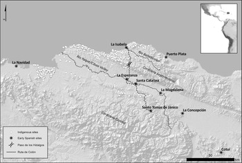
After the failure of the first Spanish settlement at La Navidad and the difficulties of building a settlement at the mouth of the Yaque del Norte River (which might have otherwise offered an easy corridor into the Cibao Valley), the first town of La Isabela was built in 1493 at the mouth of the smaller Bahabonico River (Deagan and Cruxent Reference Deagan and Cruxent2002). The construction of this new town was predicated on the presumption of wealth in its vicinity and an underlying intention to establish a route over the Cordillera Septentrional into the island's interior (Figure 1). The beginnings of a colonial trail from La Isabela into the interior of the Cibao began in 1494 with two journeys: the entrada of two Spanish captains, Alonso de Ojeda and Ginés de Gorvalán, followed by the entrada of Christopher Columbus at the head of about 400 men. The first visits to the Cibao, a region previously identified by Indigenous informants as the source of the island's gold, culminated with the creation of a second colonial enclave, the fortress of Santo Tomás de Jánico (León Guerrero Reference León Guerrero2000:300–318). Columbus's entrada into the Cibao was also related to several other strategic purposes: to alleviate the difficult logistical situation existing in La Isabela; to formalize rescates (exchanges) and taxation to obtain gold, cotton, and enslaved Indigenous laborers; and to guarantee military control over the region (Arranz Márquez Reference Arranz Márquez1991:9–10).
Northern Hispaniola, late pre-invasion Indigenous sites, and the reconstructed course of the ruta de Colón (map by Noa Corcoran-Tadd).

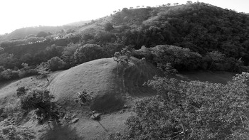
The connecting trail between La Isabela and the first inland enclave at Santo Tomás—later named the ruta de Colón—was a central part of the shift away from the initial factoría model of coastal trading posts based on previous experience along the West African coast and the beginning of a new colonial network that extended deep into the interior of the island (Figure 2). This network was consolidated by the construction of a chain of forts between 1494 and 1495—La Esperanza, Santa Catalina, La Magdalena, and La Concepción—to safeguard the regimes of extraction and mobility that yielded small but increasing quantities of gold from the northern slopes of the Cordillera Central.
Location of the Santo Tomás de Jánico fort (1494), Dominican Republic (photo by Till Sonnemann).

Recent archaeological research along the ruta de Colón has focused on the distribution and historical interconnections of Indigenous settlements (Herrera Malatesta Reference Herrera Malatesta2018; Hofman et al. Reference Hofman, Hung, Malatesta, Sony Jean, Sonnemann and Hoogland2018; Ulloa Hung Reference Ulloa Hung2014). In addition to revealing a high density of archaeological sites throughout northern Hispaniola (with more than 300 sites recorded), this research has deepened our understanding of the diverse yet interconnected Indigenous landscape at the moment of the Spanish invasion. The analysis of settlement distributions at local and regional scales suggests a pattern centered on larger habitational sites and with small to medium sites focused on other activities, such as agriculture, marine resource exploitation, crafting, and defense. Overall, these sites formed nodes in a dense network of Indigenous social connectivity that emerged over the late prehispanic period and that linked settlements across different ecological zones, from the coast to the mountainous interior (Herrera Malatesta Reference Herrera Malatesta2018; Ransijn Reference Ransijn2021; Ulloa Hung and Malatesta Herrera Reference Ulloa Hung and Herrera2015).
Early historical narratives indicate some of the ways that these Indigenous social networks connecting the coastal zone with the interior were key to the success of the first Spanish entradas. Las Casas's (Reference Las Casas1875 [1561]:29) account of these entradas illustrates the dynamics between Indigenous and Spanish mobilities, describing the use and transformation of Indigenous paths and trails to accommodate the parties journeying on foot and on horse from La Isabela over the Cordillera Septentrional via the so-called Paso de los Hidalgos and into the Cibao Valley. The chronicler Guillermo Coma also notes that Gorvalán crossed the Yaque with the help of Indigenous guides and boats and continued through the southern side of the valley based on their friendly relationships with local caciques (León Guerrero Reference León Guerrero2000:270). These resulting networks of trails and social connections, underpinned by an initial mobility regime based on Indigenous porterage labor and limited numbers of Old World animals, would continue to shape the initial Spanish presence in the Cibao as they shifted from exchanging for gold to exploiting the alluvial gold placers themselves (Hofman and Keehnen Reference Hofman and Keehnen2019).
Although several historical geographers and archaeologists have sought to reconstruct the possible trajectories of the ruta de Colón based on textual sources (Guerrero and Maggiolo Reference Guerrero and Maggiolo1988; Ortega Reference Ortega1988; Sauer Reference Sauer1966), direct archaeological evidence for Columbus's 1494 journey remains minimal (Hofman et al. Reference Hofman, Hung, Malatesta, Sony Jean, Sonnemann and Hoogland2018). This fits with a model of the ruta having low levels of formalization and a relatively short period of use following the initial entrada. Archaeological research at the route's endpoint at the Santo Tomás de Jánico fort has also pushed back against previous reconstructions of a larger plan and stone-built architecture, suggesting a smaller, briefly occupied site characterized by a more ephemeral wooden construction (Ulloa Hung and Sonnemann Reference Ulloa Hung and Sonnemann2017).
More indirect forms of evidence registered in the ongoing archaeological investigation of the surrounding landscape, however, are suggestive of the route's enduring impacts. The final radiocarbon date associated with the Indigenous site of El Flaco (immediately south of the Paso de los Hidalgos) currently stands at cal AD 1490 (Hofman et al. Reference Hofman, Hung, Malatesta, Sony Jean, Sonnemann and Hoogland2018). Multiproxy environmental records recovered from the Cibao Valley also suggest that major landscape changes—the abandonment of late precolonial cultivation practices, forest clearance, and the pasturing of Old World animals—may have begun more rapidly closer to the route of the initial entradas (Castilla-Beltrán et al. Reference Castilla-Beltrán, Hooghiemstra, Hoogland, Pagán-Jiménez, van Geel, Field, Prins, Donders, Malatesta, Hung, McMichael, Gosling and Hofman2020).
By the time of La Isabela's abandonment in 1498, the primary Spanish focus had shifted to the new port towns of Santo Domingo and Puerto Plata. These and other settlements were connected by an increasingly formalized road network and a growing reliance on animal transport from 1502 onward under the new governor Nicolás de Ovando (Mira Caballos Reference Mira Caballos2000:154). Several of the inland settlements that persisted into the sixteenth century (e.g., Concepción de la Vega and Santiago de los Caballeros) were associated with the chain of forts from the earliest years of the colony (Kulstad-González Reference Kulstad-González, Paulo, Funari and Senatore2015); the Indigenous population centers in the Cibao, the intensification of gold extraction to include more specialized operations targeting lode gold (Olsen Bogaert Reference Olsen Bogaert2015), and the new “ruta del oro” that connected these locations proved to be central factors in determining the new settlement geography of the interior.
Overall, the Hispaniola case points to a pattern of an initial colonial appropriation of Indigenous trails, with the ruta de Colón following routes that had underpinned preexisting patterns of coastal–interior connectivity. Although appropriation characterized the earliest phase of the colonial period, the archaeological evidence from Indigenous settlement patterns and the Spanish forts both suggest rapidly divergent patterns of inhabitation and mobility in the context of dispossession and demographic collapse. Recent surveys have proven that preconquest Indigenous settlement was substantial across many parts of the island, emerging as a function of local resources and political networks. By contrast, the majority of early Spanish settlements were established in those specific coastal areas that mapped onto the ship-based transportation regime underpinning much of the growing colonial network in the Caribbean (Altman Reference Altman2017). Although the regime of mineral extraction established in the earliest years of the colony and reliant on a declining labor force would continue into the middle of the sixteenth century, it quickly became articulated with a new mobility regime based on increasingly formalized roads and animal transportation that centered on the island's new Atlantic and Caribbean ports.
Case 2: Pearling and the Botuto Route (Southeastern Caribbean)
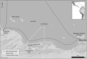
The maritime networks of the southeastern Caribbean form the second case study with which to explore the interplay among Indigenous mobilities, marine resource materialities, and the emergence of new colonial sea routes in the sixteenth century. While the archaeological landscapes of preconquest gold extraction on Hispaniola remain little known, the southeastern Caribbean provides an instance where we can directly trace the ways that Indigenous resource routes were dramatically disrupted by the early colonial Spanish networks of pearling enclaves and staging points for entradas into the South American mainland. Recent archaeological investigations in the region have revealed a material record of the dynamic late precolonial circuits of local and interregional exchange across the region (Antczak et al. Reference Antczak, Haviser, Hoogland, Boomert, Dijkhoff, Kelly, Antczak, Hofman and Reid2018; Biord Castillo and Arvelo Reference Biord Castillo, Arvelo, Pacheco, Gordones and de Briceño2007). We focus here on one of these precolonial maritime routes—the so-called botuto route—and its early colonial transformations (Figure 3). This route operated between north-central Venezuela and the offshore islands to the north and was related to the massive exploitation of the queen conch (botuto [Lobatus gigas]) on the Los Roques Archipelago between about AD 1000 and 1500 (Antczak and Antczak Reference Antczak and Antczak2006). The establishment of Spanish settlements in eastern coastal Venezuela during the early sixteenth century, driven in large part by a new focus on the exploitation of another shellfish resource (the pearl oyster, Pinctada imbricata), would substantially remake the broader southeastern Caribbean seascape and ultimately lead to the collapse of the botuto route.
The southeastern Caribbean and the botuto route (map by Noa Corcoran-Tadd).

The long-distance routes connecting the northwestern coast of Venezuela and the ABC islands (Dutch Caribbean) and relating to the harvesting and exchange of the botuto had deep roots in the region's preceramic Archaic Age (Kelly and Hofman Reference Kelly, Hofman, Hofman and Antczak2019). Characterized by high quantities of meat, large shells, and dense and resilient shell beds, the botuto came to form an important element in regional subsistence, crafting, and ritual practices. By around AD 200, abundant remains of conchs, both as shells and as crafted body ornaments, also began to appear inland in the Venezuelan Andean piedmont region (Vargas Arenas et al. Reference Vargas Arenas, Toledo, Molina and Montcourt1997).
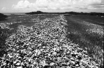
Within this context, the emergence of the maritime botuto route after AD 1000 on the central Venezuelan coast represented a step change in the scale and significance of botuto exploitation. Communities associated with the Ocumaroid (ca. AD 200–1250) and subsequently the Valencioid (ca. AD 800–1500) archaeological cultures began to travel seasonally via dugout canoe between the coast and the Los Roques Archipelago (Antczak and Antczak Reference Antczak and Antczak2006:100–101). On the basis of systematic archaeological and bioecological surveys and excavations of the massive shell middens located on the archipelago (Figure 4), it has been calculated that up to three tons of salted or sundried botuto meat were brought yearly from the island campsites via routinized canoe routes to mainland settlements during the three centuries before the European conquest (Antczak and Antczak Reference Antczak, Antczak, Antczak and Cipriani2008). Such a large influx of protein likely had multiple and profound impacts on Valencioid foodways, economy, politics, and ideology. The botuto route also came to extend substantially inland from the coastal departure points (Antczak and Antczak Reference Antczak and Antczak2006) via long-distance trails over the Cordillera de la Costa (2,800 m asl) and into the Lake Valencia basin and the mountainous valleys to the east (Herrera Malatesta Reference Herrera Malatesta2011).
A botuto shell “mega-midden” on Cayo Sal, Los Roques Archipelago, Venezuela (photo by Andrzej Antczak).

A sharp discontinuity in the archaeological record on Los Roques suggests that the Indigenous maritime botuto route was disrupted after 1498 by the appearance of Spanish seagoing ships along the Caribbean coast of Venezuela. Since the beginning of the sixteenth century, so-called armadas de rescate from Cubagua, Santo Domingo, and Puerto Rico had moved along the mainland coasts and into the interior, indiscriminately and often violently “gathering” gold objects, guanín (body adornments crafted in an alloy of gold, silver, and copper), foodstuffs, and enslaved laborers (Otte Reference Otte1977:96–107). These early maneuvers of Spanish and German expeditions, often operating on the margins of the formal colonial administration, not only engaged in direct violence against Indigenous individuals and communities but also led to wider destructive impacts on patterns of exchange, alliance building, and their underlying value systems.
The colonial presence along the coast was increasingly formalized with the founding of the Spanish town of Nueva Cádiz (1528) on the island of Cubagua and of the seat of the Welser colonial venture at Santa Ana de Coro (1527). Oriented toward the pearling boom around the island of Cubagua on the eastern coast and toward exploratory ventures into the western interior, respectively, these two colonial nodes formed part of a triangular route that connected them to the inter-Caribbean network centered on Santo Domingo, the seat of the Real Audiencia that oversaw the Caribbean and its mainland coasts (Otte Reference Otte1977). At the same time, sites like Nueva Cádiz and the rancherías (specialized campsites) on the surrounding islands of Margarita and Coche appear to have been substantially dependent on canoe-based Indigenous mobility regimes both for the exploitation of the pearl beds and for the provisioning of growing populations on the subsistence-poor islands (Antczak et al. Reference Antczak, Antczak, Antczak, Buffet, Hofman and Keehnen2019).
Archaeological research has begun to clarify some of the broader impacts of the Spanish invasion on the Venezuelan coast that often unfolded beyond the reach of the textual record, including the destruction of the botuto route in the early sixteenth century. As suggested both by the radiocarbon dates and by the absence of European material on the islands, the voyages to Los Roques and other offshore islands appear to have been ended abruptly by the Spanish, who categorized the communities of central mainland Venezuela as rebellious “Caribs” resisting colonial rule until the last quarter of the sixteenth century (Antczak and Antczak Reference Antczak and Antczak2006:413).
Spanish visits to the islands during this period were brief and were limited to two ephemeral episodes that reflect a radically different engagement with the islands and their resources. First, there were visits in the 1530s by Spanish and Indigenous divers who frenetically searched for pearls at Los Roques and at other neighboring islands in the context of diminishing returns from the primary pearl oyster beds around Cubagua (Antczak et al. Reference Antczak, Castillo, Rivas and Antczak2020). The second visit occurred in 1589 when the offshore islands were inspected by Spanish officials with the help of Indigenous guides and were formally declared possessions of the Crown. Archaeology and documentary sources indicate that the Los Roques islands would subsequently remain uninhabited, their rich conch shell beds of little interest to Spanish colonists.
The complexity of the emergent sixteenth-century colonial seascape is highlighted by the fact the Las Aves Archipelagos to the west continued to be visited sporadically by the Caquetío people (Arawakan-speaking descendants of precolonial Dabajuroid communities), who were navigating from the ABC islands. The Caquetío and their relatives from the mainland coast were considered guaitiaos (Indigenous allies) by the Spanish, and this status enabled them to visit these islands to continue traditional resource exploitation practices (Antczak and Antczak Reference Antczak and Antczak2015). In this case, discrepant colonial categorizations of Indigenous communities shaped the new landscape of movement across the southeastern Caribbean, with the “bellicose Caribs” cut off from the botuto route to Los Roques while the allied Caquetío were allowed a certain persistence of maritime mobility between the ABC islands, the Las Aves Archipelagos, and the mainland.
Although more archaeological research remains to be conducted in the region, it seems clear that, by the early sixteenth century, the traditional maritime botuto route had been disrupted by the Europeans, with no evidence for continuities during the colonial period. With their reorientation toward new resources such as the highly concentrated pearl oyster beds in projects that were, at the same time, highly dependent on traditional canoe-based mobilities, European colonists had no interest in the specific resources of the offshore Los Roques and Las Aves Archipelagos: the botuto would not be exploited at a large scale again until the second half of the twentieth century (Schapira et al. Reference Schapira, Irene Montaño, Antczak and Posada2009).
Case 3: The Ruta de la Plata and the Camino del Mercurio (Central Andes)
By the end of the sixteenth century, the central Andes had emerged as one of the major political and economic hubs of the Spanish colonial Americas. The urban centers of Lima, Cuzco, and Potosí had come to dominate the new territory of the viceroyalty of Peru, which saw considerable economic growth following the recovery from the civil wars of the 1540s and implementation of the reforms of Viceroy Francisco Álvarez de Toledo (1569–1581). Although not the only driving process behind this dramatic growth, the expansion of silver mining in the south-central Andes was a central factor. As both contemporary observers and modern historians have emphasized, these mining landscapes quickly became one of the pillars of the colonial economy, particularly following the much-discussed reorganization of the mita labor tribute system in the 1570s (Bakewell Reference Bakewell1984; Barnadas Reference Barnadas1973). Many historical accounts of silver and mercury mining in the Andes have tended to focus on this better-documented post-reform period, thereby eliding the important late prehispanic and pre-reform periods of resource extraction. Over the past decade, a turn to the archaeological study of these landscapes of extraction has provided important insights that complicate previous narratives and periodizations.
Although these landscapes often acquired narratives of Spanish “discovery” in the early colonial period—for example, Potosí in 1545 (Platt and Quisbert Reference Platt, Quisbert, Cruz and Vacher2008) and Huancavelica in 1559 (Lohmann Villena Reference Lohmann Villena1949:11–14)—archaeological research has revealed a more complex picture of long-term mineral exploitation before the Spanish invasion. Survey of the landscapes surrounding the most important early colonial silver mining centers in the south-central Andes—Potosí, Porco, and Oruro—has revealed evidence for extractive and processing activities during the Inca period (Cruz et al. Reference Cruz, Téreygeol, Küng, Fernández and Casanovas2017; Van Buren and Weaver Reference Van Buren and Weaver2012). In addition to these spatial continuities over time, this research has also shown the complexity of the changing extractive regimes during the colonial period, highlighting the persistence of multiple scales and modes of organizing extraction from large-scale efforts based on tributary labor and the mercury-dependent amalgamation process to decentralized efforts based on independent Indigenous extractive ventures and the processing of ore through smelting.
With the introduction of amalgamation in 1572, which enabled the processing of larger amounts of lower-yield silver ores, the landscapes of silver and mercury extraction in the Andes became inextricably linked. The mercury mine at Huancavelica in the central Andes proved to be the only location in the region with significant and relatively accessible deposits of cinnabar ore. Again, there is suggestive evidence for spatial continuities in the exploitation of cinnabar in the area, with sediment cores near Huancavelica suggesting a dynamic history of ore extraction beginning by 1400 BC for the production of cinnabar pigment and continuing through the colonial period with the shift to the production of liquid mercury based on mita labor in the sixteenth century (Cooke et al. Reference Cooke, Balcom, Biester and Wolfe2009; Smit Reference Smit2018).
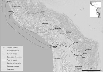
As previously emphasized, such colonial extractive regimes must be placed within their wider and longer-term landscapes of mobility (Corcoran-Tadd Reference Corcoran-Tadd and DeCorse2019). Research in the colonial archive has provided important insights on sixteenth- and seventeenth-century mobilities in the central Andean region and the ways that new resources came to circulate through this rugged landscape (Gil Montero Reference Gil Montero2009; Glave Reference Glave1989; López Beltrán Reference López Beltrán2016). This work has highlighted the emergence of two major resource-oriented routes: the ruta de la plata and the camino del mercurio. Caravans transported silver from the mines in the altiplano along the official ruta de la plata to Lima, initially following an overland route via La Paz and Cuzco and subsequently following a mixed overland/maritime route via Arica (Figure 5). The camino del mercurio ensured the provision of mercury from Huancavelica to Potosí, following a similar evolution from overland to maritime routes during the final decades of the sixteenth century.
The south-central Andes, major mining areas, and the ruta de la plata and the camino del mercurio (map by Noa Corcoran-Tadd).

To what extent did these colonial routes build on Indigenous mobilities? The extensive Inca imperial road network (qhapaq ñan) had integrated the largest polity in the New World before the Spanish invasion (Chacaltana et al. Reference Chacaltana, Arkush and Marcone2017; Hyslop Reference Hyslop1984). Prior to the creation of this formalized network, the previous millennium had seen the flourishing of long-distance transport regimes based on caravanning and porterage that connected highland and coastal communities across the central and south-central Andes (Tripcevich and Capriles Reference Tripcevich and Capriles2016). Even though both the Inca road network and the caravanning tradition formed important legacies that shaped the emergent landscape of mobility during the colonial period, these legacies have often been asserted in general terms, rather than demonstrated through concrete archaeological evidence for continuities and transformations.
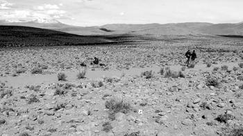
As recent archaeological investigations of colonial routes in the region have shown, making rigorous distinctions between the reuse of prehispanic road networks and the “reinvention” of routes through the topographically restricted landscapes of the Andean highlands remains a difficult problem (González Godoy Reference González Godoy2017). Clearer evidence for continuities has come from the archaeology of colonial caravanning routes in southern Peru and northern Chile (e.g., Borie et al. Reference Borie, Castro, Várela and Aldunate2016; Nielsen et al. Reference Nielsen, Berenguer and Sanhueza2006). Notably, some of the sites along the ruta de plata appear as informal reoccupations of roadside waystations (tambos) originally built during the Inca period. Many, however, take the form of ephemeral campsites (pascanas or jaranas; Figure 6) that index the persistence of caravanning traditions with deeper pre-Inca roots in the region (Corcoran-Tadd Reference Corcoran-Tadd2017; García-Albarido Reference García-Albarido2017; Santoro et al. Reference Santoro, Williams, Valenzuela, Romero, Standen, Malpass and Alconini2010). Archival and archaeological evidence also point to the emergence of new hybrid transport regimes that combined camelid and mule caravans based on the complex trade-offs between their relative carrying abilities, environmental adaptations, pasturing preferences, and herd demography (Corcoran-Tadd Reference Corcoran-Tadd and DeCorse2019; Sanhueza Reference Sanhueza and Hubert2011).
Recording a colonial caravan campsite (PATT18-011) along the ruta de la plata in the highlands of Arica y Parinacota, Chile (photo by Noa Corcoran-Tadd).

The archaeology of the camino del mercurio between Huancavelica and the port of Chincha shows a parallel process of continuity and transformation. Although the earliest shipments of mercury to Potosí appear to have followed older routes along the primary highland trunk road of the Inca network, archaeological survey indicates that the Huancavelica-Chincha route established in 1574 did not follow a major Inca road to the coast (contrary to Bernabé Romero Reference Bernabé Romero2015). Rather, the new route with its newly constructed waystations represented the formalization of older regional trails (Bauer et al. Reference Bauer, Smit, Blanco, Rodríguez, Chacaltana, Arkush and Marcone2017) and the appropriation of preexisting caravanning transport regimes to articulate with the new possibilities for high-volume transport via coastal shipping.
In connecting these early colonial landscapes of extraction and mobility, it is vitally important to highlight the specific qualities of the materials (silver and mercury) that flowed through them. Although these materials are often rendered as abstract commodities within the colonial marketplace, their specific densities, purities, toxicities, distributions, and topographic contexts shaped their possibilities for extraction, refinement, movement, and exchange. The transformation of silver into a “bulk” precious metal—with 1,700,000 kg of silver extracted at Potosí during the 1590s (TePaske Reference TePaske2010:183)—raised novel problems of scale. In addition, the location of the most productive ore deposits deep in the Andean interior meant that some of the region's harshest environments—the cold altiplano and the hyper-arid Atacama Desert—lay between them and the rest of the viceroyalty. In combination, these qualities appear to have been key variables in maintaining the enduring reliance on preexisting Indigenous transport regimes.
At the same time, the possibility of using amalgamation to process growing quantities of low-grade silver tailings intersected in the 1570s with new political pressures from the growing class of mine owners to organize a reliable supply of mercury (Cole Reference Cole1985:4–15). The very limited locations of cinnabar at a continental scale (with Huancavelica emerging as the only sufficiently productive deposit in the New World) combined with the new demand to influence the making of new interregional routes that only partly overlapped with prehispanic road networks.
In the central Andean case, therefore, we see a persistence of Indigenous transport regimes—roads, technologies, actors—that would shape the ways that silver could be constituted as a central resource for the colonial economy. Although the scale of extraction in the Andes soared to unprecedented heights during the early colonial period, recent archaeological and archival research has shown that the modes of transforming ore into a major circulated commodity during the sixteenth and seventeenth centuries were embedded within preexisting Indigenous transport regimes, as well as extractive regimes that built on older Indigenous technical and organizational forms (Van Buren and Weaver Reference Van Buren and Weaver2012). At the same time, recent archaeological surveys have shown both that these routes often built on local trails and mobilities (rather than simply retracing the macroregional qhapaq ñan network) and that they were responsive to new pressures, such as the gradual introduction of mule trains with their own mobility characteristics, indicating that the colonial reuse of Inca roads needs to be carefully demonstrated rather than simply asserted.
Connecting the Routes
Our approach demonstrates several insights afforded by the archaeological examination of precolonial and colonial routes and resource materialities together in a single analytical frame. First, the adoption of wider spatial scales of analysis enables a clearer understanding of the articulations between extractive and transportation landscapes that have otherwise tended to be examined in isolation. In taking determinedly multisited approaches, the three case studies highlight the possibilities of tracing the chains of quotidian spaces—trails, fortified outposts, shell middens, caravan campsites—that constituted the new networks of colonial extraction and mobility across the Americas. The interregional comparison of the three cases also responds to earlier calls for synthetic approaches that move beyond persistent tendencies to particularism in the historical archaeology of Spanish colonialism.
Second, the transconquest perspective—enabled by the archaeological attention to deeper chronologies—highlights patterns of persistence and appropriation of existing Indigenous transport regimes over the longer term, recentering questions about the “finding” of the routes and resources that would shape the landscapes of the early colonial period. At the same time, the three case studies outline some of the divergent trajectories of appropriation and erasure across the region: whereas the Andean case shows clear evidence of the longer-term persistence of certain Indigenous routes through the colonial period, investigations on Hispaniola show only an initial appropriation of preexisting routes, and the southeastern Caribbean case highlights significant ruptures in previous patterns of mobility.
Third, the attention to transport regimes and their articulation with extraction regimes pushes us to take a renewed look at the making of colonial resources across the Spanish Americas. As we show in our discussions of gold, silver, mercury, queen conch, and pearl oysters, such materials were (re)constituted as exploitable resources through their articulation with colonial route-making. In this sense we engage with but also distance ourselves from traditional studies of resource geography and commodity histories. Rather than falling back on traditionally deterministic views of resource distributions and dematerialized commodity flows, the relational and historically contingent nature of colonial routes and their associated resources can be brought to the fore to rethink key variables, such as rates of extraction and accessibility costs as deeply intertwined with Indigenous knowledge, coercive labor practices, and demographic decline.
Comparisons among the three cases show how the resource materiality perspective can broaden our understanding of the many important factors shaping the divergent histories of resource extraction in the colonial Americas. Pearl and particularly gold sources were relatively dispersed, with lower volumes and higher rates of exhaustion in comparison with the more centralized major silver mines in the Andes that had high-volume outputs and longer periods of exploitation. In addition, the gold sources in Hispaniola were relatively accessible to seaports, whereas the major Andean mines were isolated by the high-altitude desert of the altiplano. As a result, while recent archaeological research has shown how these two areas were both characterized by densely interconnected landscapes of preconquest trails and roads that proved fundamental to the early Spanish entradas, contrasting resource materialities were one of the key factors that pushed the historical trajectories of these two routes in very different directions. The southeastern Caribbean case highlights a further contrasting dynamic: the Indigenous and colonial extractive projects targeting superficially similar shell resources led to divergent outcomes, with the Spanish expansion across the Venezuelan littoral (partly based on the appropriation of the local canoe-based transport regime) driving both the exhaustion of the region's pearl beds and the abandonment of the long-standing botuto route. Finally, the interplay between new land and sea routes appears to have played a major role in instances of discontinuity, with port nodes like Puerto Plata, Nueva Cádiz, and Chincha articulating the much more flexible Spanish seascapes with newly shifting land routes.
Although the comparisons developed in this article are preliminary, they point to the possibilities of comparative approaches to other mobility regimes—from the networks of smuggling in the Caribbean and the southern Andes to the formalization of the royal roads and postal systems across the Americas during the eighteenth century—that emerged to connect both internal markets and the broader Spanish colonial world and whose large scales remain persistent challenges for historical archaeologists in the region. At the same time, our attention to landscape and long-term timescales in the three case studies underlines the potential specific insights offered by archaeology for the wider resource materialities program, a perspective that looks beyond the horizon of the twentieth century to consider much deeper colonial and, indeed, precolonial histories of mobility and extraction.
Acknowledgments
The research leading to these results received funding from the European Research Council under the European Union's Seventh Framework Programme (FP7/2007–2013)/ERC-NEXUS1492 grant agreement 319209 (ERC-Synergy Nexus1492) and from the Rust Family Foundation. Permits and supervision from the Ministries of Culture of the Dominican Republic and Peru, the Instituto del Patrimonio Cultural of Venezuela, and the Consejo de Monumentos Nacionales of Chile enabled this research. Jorge Ulloa Hung is also affiliated with the Royal Netherlands Institute of Southeast Asian and Caribbean Studies and the Faculty of Archaeology, Leiden University (Leiden, The Netherlands). No financial or institutional conflicts of interest exist.
Data Availability Statement
Data from the case studies will be available in the NEXUS1492 thematic collection on the Data Archiving and Networked Services platform (DANS). Additional data can be requested from the corresponding author (noac@princeton.edu).