County Durham
(1) Piercebridge, 21 The Green, Piercebridge, Borough of Darlington (NZ 21017 15675): archaeological monitoring during the excavation of foundation trenches for a single-storey extension to No. 21 The Green, Piercebridge, was undertaken in April 2024.Footnote 37 The property was of interest as it was situated in the south-east corner of Piercebridge Roman fort (possibly Morbium), where earlier phases of excavation had uncovered part of a large double-courtyard building.Footnote 38 It was the continuation of this building that was uncovered during the archaeological monitoring works. Roman levelling deposits were encountered across the site which can be equated with a widespread layer of brown clay recorded during previous work on the internal buildings of the fort and interpreted as an ‘imported levelling dump’ laid down in preparation for the construction of the fort’s internal buildings.Footnote 39 Structural remains cut into these levelling deposits comprised a c. 0.60 m wide east-west sandstone wall that ran parallel to a wall recorded in the mid-1970s within the rear garden of No. 22 The Green that borders the site to the north.Footnote 40 An additional wall was also uncovered in the back lane immediately to the east of the development site. Collectively these structures represent one of the walls of the putative central east–west corridor running between the two courtyards of the overall building discovered in the 1970s.Footnote 41
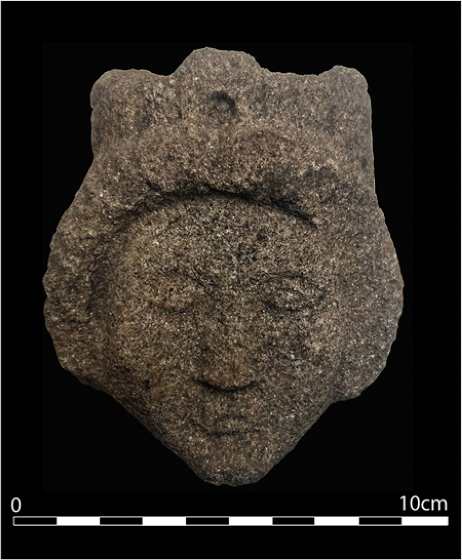
SF24523. The head of a female deity with a mural crown (© The Vindolanda Trust).

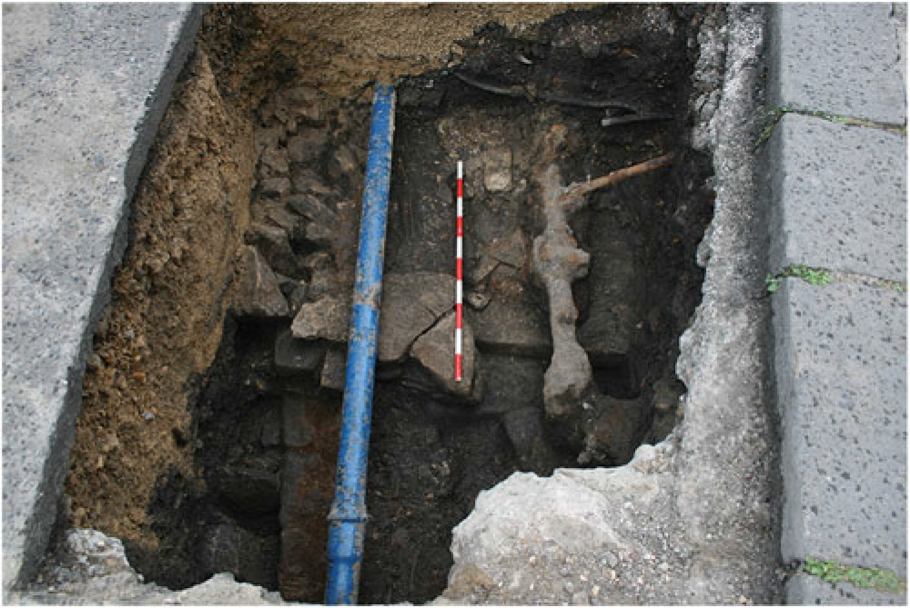
Trench 5 showing possible wall of Pons Aelius barrack block (bottom left) with post-Roman demolition material (top left, centre, and top right) and two early medieval graves (at top and bottom of photo immediately to the right of the blue pipe). View west, 1 m scale (© Pre-Construct Archaeology Ltd).

(2) Dalton Piercy (NZ 46219 31448): an extensive enclosure system was recorded, concentrated in the centre and north of the site, probably as part of a single larger field system. Three sides of a large enclosure were recorded in the north, within which were three smaller ditches, probably the remnants of sub-enclosures, and several small pits. A small rectangular enclosure was identified in the centre of the site, with a longer ditch to the east. The ditches corresponded to the geophysical survey. The enclosure had several recuts and realignments, indicating use over a long period of time. Two parallel ditches in the west of the site may have formed a driveway. No traces of habitation such as roundhouses or hearths were identified, suggesting that the settlement lay beyond the site boundary. The palaeoenvironmental assemblage indicated that the features were Iron Age/Romano-British in date, and indicated the cultivation of spelt wheat and barley, livestock farming and grassland. This is a stark contrast to the wooded environment that preceded it. The decrease in woodland led to the exploitation of heathland for turf fuel and small-scale domestic use of coal. Radiocarbon dates spanned a.d. 210–430, and the pottery assemblage mainly dated to the fourth century a.d. The pottery found was typical of late Roman rural sites, where preparation of food was the pottery’s main function.Footnote 42
North Yorkshire
(1) Aldborough (Isurium Brigantum), Roman town (SE 4414 4678): a new trench was opened immediately to the west of the Roman road c. 70 m to the north of the North Gate of Isurium Brigantum. The excavation sought to characterise the area within the enclosed annexe to the town’s defences that had been identified in our earlier surveys. The limited excavation revealed a sequence that started in the second century a.d. The earliest phase of activity is probably represented by a single shallow beam slot which was by a series of cut features of Period 3B. It produced only a couple of sherds of pottery which are not datable. The evidence is consistent with the commencement of activity in this part of Aldborough in the second century. The samian assemblage suggests that there was little activity before c. a.d. 120, with only a little residual earlier material. This implies that the excavation was located outside the limits of first-century settlement. A stone building was demolished in the late-second century leaving a substantial hollow that was back-filled with rubbish. A single inhumation burial was cut into the resultant hollow, and a series of small pits were dug nearby. There was very limited evidence for deposition in the area later than the third century.Footnote 43
(2) Skeeby, Skeeby Solar Site Cable Route (NZ 19578 01779 and NZ 20904 01748): an archaeological watching brief was undertaken by CFA Archaeology on two parcels of land at Skeeby Solar Site, North Yorkshire in January and May of 2024. Sections of the cable route to monitor were determined by previous evaluation work. A late Iron Age to early Romano-British settlement was identified, confirming the earlier geophysical survey and archaeological evaluation. Features included linear ditches indicative of agricultural activities or enclosures, segments of ring ditches which were likely part of a group of round houses and a pit of burnt material suggestive of small-scale industrial works. The narrow width of the cable trenches meant that further interpretation, including more precise dating and explanation of historic activities, is limited.Footnote 44
(3) York, Northern House, Rougier Street (SE 59439 50956): geoarchaeological investigation has culminated in two phases of borehole monitoring (2019 and 2025), alongside limited archaeological evaluation trenching. There have been fascinating insights into Roman occupation of the southern bank of the river Ouse within what was the Roman Colonia. Extensive deposits of silt-rich alluvium were recorded between around 3.85 m and 6.60 m aOD throughout the site, within which were numerous cut archaeological features and deposits. These correspond with the presence of extensive archaeological remains consisting of pottery, bone, ceramic building material and mollusc-shell fragments. Diagnostic pottery fragments present included Iberian-style amphora sherds, Samian ware, and assorted locally or regionally produced Romano-British wares. The pottery remains suggested a period of activity between the second and fourth century a.d. Radiocarbon dating from throughout this alluvium was consistently between c. 110–240 cal. a.d. (1870–1920 b.p.; BETA-740236-740241), suggesting a second–third-century period of deposition.
The silt had a high organic content including visible botanical macrofossils and extensive deposits of leather, including off-cuts and scraps, and a shoe sole. These leatherworking remains provide further evidence of a leatherworking industry within this area of the Eboracum Colonia. The above second–third-century radiocarbon dates represent the first attempts to utilise absolute dating directly to establish a chronology for this industry. Excavations at 5 Rougier Street demonstrated evidence for a large granary fire which had occurred at the site as illustrated by a thick layer of burnt grain and a charred timber which destroyed the building and required the site to be redeveloped in the late second century.Footnote 45 Concentrations of burnt grain were recorded by the 2019 Northern House boreholing at identical elevations. The 2025 boreholing did not record burnt grain deposits, but microfossil assessment demonstrated extensive concentrations of microcharcoal within the sequence at the corresponding elevation. It may be that this represents finer burnt particulates which have been transported further from the source of the conflagration. Collectively, there is evidence that this second-century fire may have engulfed a relatively significant portion of Eboracum.Footnote 46
East Riding of Yorkshire
(1) Brough, Welton Road, Elloughton-cum-Brough Parish (SE 8516 2682): a Strip, Map and Record (SMR) excavation to investigate the remains of a north-east–south-west Roman ditch dated to the second century a.d. which had previously been revealed during an evaluation (2023). The work further exposed the feature across the proposed development area and an additional gully parallel to it, but did not add to the ceramic assemblage. Despite the differing dimensions and the termination of the second gully to the north, this pair of linear features were interpreted as evidence for the remains of a possible ‘trackway’, associated with agricultural activity that had supported the nearby Romano-British settlement of Brough. The general paucity of finds materials from the remains also indicated a position on the periphery of more intensive occupation. Finds of generally higher status have been recovered from Welton Low Road, some 650 m north of the site, where the remains of Romano-British ditches were uncovered flanking a Roman road. The Roman land use was in keeping with the results of other excavations elsewhere in the vicinity including Brough South, to the southeast of an earlier Iron Age/early Roman settlement. Brough (formerly known as Petuaria) was located within the territory of the Iron Age parisi and was an important urban centre in the area that is now East Yorkshire, no doubt linked to the Roman roads extending from Newcastle down to Lincoln and another across to York. The settlement could also boast of a natural harbour.Footnote 47
(2) Brough on Humber (Petuaria), Burrs Playing Field (SE 93947 26882): the aim was to continue to investigate the north-east corner of the defences to gain better understanding of the construction of the ramparts first excavated by Philip Corder in the 1930s. Until 1971/2, the playing field had been arable farmland. Once the ploughsoil had been removed, the top of the clay rampart was immediately visible. Sections through this showed the laminated layers of clay and other material, and the outlines of the original spadefuls of clay and turfs could be seen in plan, although there was no obvious coherence, and the impression was that the rampart had been constructed quickly. Under this was a layer of irregular blocks of limestone, forming a solid foundation for the rampart above. Finds were few, but included oyster shells, animal bone and small pottery sherds. The pottery within and above the rampart consisted of local greywares, Nene Valley colour coats dating from the third century a.d. and small sherds of samian, which was almost certainly residual. At regular intervals deposits and spoil were metal-detected and sieved. Finds included a coin of the Gallic Emperor Victorinus (a.d. 269–271), the obverse of which was in good condition and showed the curly-bearded head of the emperor with a radiate crown. Below the stone base was what Corder had labelled the sand rampart. This too was laminated with layers of sand and clay. It contained many more finds than the rampart above. There was a relatively high proportion of samian, both plain and decorated, with two stamped bases. Coarse wares included oxidised Ebor wares, Black Burnished ware and sherds of a rusticated vessel generally dated to between a.d.70 and 120. Special finds from this deposit included a circular copper-alloy plate brooch, a fragment of glass bangle, a dice and a copper-alloy nail cleaner. What was probably the base of the sand rampart was only reached on the last day in a small area. Thanks to a grant from the Society of Antiquaries of London, similar deposits found in the 2022 excavation were radiocarbon-dated to 49 cal a.d.–117 cal. a.d. (68.3 per cent probability) and 16 cal. b.c.–126 cal. a.d. (93 per cent probability) (SUERC-128163 (GU68607)).
In the 2023 season, trenches were opened in gardens immediately to the east of the Burrs. The 2023 excavation uncovered an upper surface of larger stones thought to be half of the road and one of smaller stones about 50 cm underneath. The aim in 2024 was to try to find the road surfaces in the neighbouring garden. Under the thick layer of topsoil was a sandy deposit containing several sherds of medieval pottery. This had been cut by a field drain. Below the sandy layer was a random cluster of crude limestone blocks. At the western end under a layer of larger stones was a surface which resembled the lower of the two possible road surfaces excavated in 2023. This had been truncated by an irregular pit. Roman finds were scare but included part of a tegula and sherds of greyware. Under the stones at the eastern end of the trench the ground became waterlogged, and underneath the stone layer were substantial pieces of wood. During the excavation, the radiocarbon dates awarded by the Community Archaeology Radiocarbon Dating Fund sponsored by Archaeological Research Services came through with some surprises. A piece of field maple from between the two layers of supposed Roman road found in 2023 was dated to 421–572 cal. a.d. (95.4 per cent probability) (SUERC-127052). The red deer antler found in what may be the upper surface of a Roman ditch in the northernmost of the two gardens excavated in 2023 was also dated to 420–567 cal. a.d. (95.4 per cent probability) (SUERC-127053). If these dates are correct, they present an intriguing picture of post-Roman Petuaria.Footnote 48
(3) Melton, OMYA Wind Turbine Project (SE 97863 28675): archaeological trial trenching was undertaken by CFA Archaeology Ltd in August 2024 for the OMYA Wind Turbine Project at Melton, East Yorkshire. Ten trenches were excavated, mostly to target geophysical anomalies identified during an earlier survey. All anomalies noted as probable archaeology were identified, confirming the presence of an enclosure system. A single sherd dating from Iron Age to Roman was found in the fill of one of the enclosure ditches.Footnote 49
North Lincolnshire
(1) Barton-upon-Humber, Land off Caistor Road, (TA 042 21): an evaluation of 34 trenches revealed two parallel north-west–south-east aligned ditches, measuring c. 475 m long, up to c. 3.0 m wide, with depths in places exceeding 1.3 m. They were initially identified in the preceding geophysical surveyFootnote 50 and were associated with an enclosure, which was likely a later addition added during the Iron Age or Roman era. A range of finds were recovered from the ditches, including a prehistoric flintwork, and Middle Bronze Age, Iron Age and Roman pottery. The exact origin of the ditches remains unclear, although it is likely of some antiquity, plausibly relating to a prehistoric routeway and/or linear monument, and later reutilised during the Later Iron Age and Roman periods. Further mitigation work would be needed to improve our understanding of the age and function of the site.Footnote 51
(2) Kirton in Lindsey, Former RAF Kirton, (SK 9425 9774): as a condition of planning permission for the construction of up to 350 residential dwellings and associated infrastructure, initial work was undertaken to evaluate areas that were inaccessible during an earlier phase of trial trenching (2023), the results of which further SMS mitigation were designed to investigate. The Strip, Map and Sample (SMS) excavations revealed a ditched Roman enclosure and associated field systems probably representing agricultural activity on the periphery of the settlement it supported. That crop processing constituted part of this economy was attested to by two corn-drying kilns within the enclosure, with evidence for fired clay linings or superstructure. Carbonised grains of barley, wheat, spelt and rye wheat were recovered from these structures. Radiocarbon dates from a particularly high concentration of charred wheat indicated later Roman usage. This was supported by a fair assemblage of Roman pottery sherds, although intrusive Saxon pottery in the same structures attested to later general activity in the vicinity and a possible continuity between the two periods. A Roman limestone quarry was identified to the west of the enclosure, conceivably related to the extraction of building material for the construction of the known Roman villa to the west of the site; other Roman remains in the vicinity of the site included further villas to the north and south, and Ermine Street Roman Road less than 2 km to the east. Comparable instances of Roman quarry sites proximal to settlement sites have been identified at Bauncewell, Sleaford, in the North Kesteven district of Lincolnshire and thought to have been active in the second century a.d.Footnote 52
Lincolnshire
(1) Folkingham, Washdyke Solar Farm (TF 09139 34405): an evaluation revealed multi-period archaeological activity, identified across 29 of the 55 evaluation trenches. A preceding geophysical surveyFootnote 53 suggested four distinct concentrations of activity likely representing rectilinear enclosures all broadly on the same alignment; one was situated to the east, close to the known Roman road that bounds the site to the east as Mareham Lane,Footnote 54 one at the centre and two to the west. The enclosure to the east comprised a c. 110 m × 60 m rectilinear enclosure with internal sub-divisions, appearing to have initiated in the second century and mostly fallen out of use in the late-third/fourth century; however, some ditches may have been maintained into the seventh to ninth centuries. A post-built structure comprising a line of stone-packed post-holes was also identified; although not well dated it was thought likely to be contemporary with the Roman activity. The central rectilinear enclosure was identified as a series of ditches that bounded an area c. 75 m × 55 m. All the ditches produced Roman pottery dating from the second to third centuries, but late-third/fourth-century pottery was less frequent than within the enclosure to the east, plausibly indicating a hiatus in activity during this era. A high-status graveyard of at least 13 individuals was exposed in plan, with associated dating evidence indicating a post-Roman mid-fifth- to seventh-century date, although some limits of the graveyard may have re-utilised those of an earlier Roman enclosure that probably survived as an earthwork feature during this period. The third and fourth areas to the west of the site suggested earlier settlement, dating plausibly as early as the Later Iron Age. The third rectilinear enclosure system was laid up along the sides of a trackway and was the largest, measuring c. 120 m × 95 m. It produced a sparse pottery assemblage dating from the Late Iron Age through to the fourth century a.d.; the most common, however, was dated to the third to fourth centuries, indicating the principle focus of occupation was during the later Roman period. A rich environmental assemblage, including charred grain, alongside fragments of quern stones was recovered, suggesting crop processing in the area and a rural focus.Footnote 55
(2) Horncastle, Land off Boston Road (TF 26181 68163): excavation revealed a multi-period site with several Romano-British enclosure ditches that aligned with the features observed in the preceding geophysical survey and exposed during evaluation trenching.Footnote 56 The Romano-British activity appears to be continuous from Later Iron Age activity, though the boundaries of the rectilinear field system appear redrawn. The enclosure systems were indicative principally of agricultural use; however, small finds assemblages suggest localised domestic and craft activities in the vicinity. Notably, the Later Iron Age/Romano-British enclosure system appeared to respect a Later Neolithic to Early Bronze Age circular monument and suggests that it survived at least in part as an earthwork. Further analysis is currently planned, principally focused on the prehistoric activity.Footnote 57
(3) Londonthorpe, Church Lane, Welby Parish (SK 9653 3709): an evaluation comprising 95 trial trenches to assess the archaeological potential of the proposed development area and inform possible further mitigation. The work was required for the determination of a planning application for a solar energy farm. Archaeological remains dating from the prehistoric to Roman periods were known in the vicinity of the site, including cropmarks of possible prehistoric land use visible on aerial photographs and an enclosure of possible Iron Age to Roman date detected through geophysical survey. Two concentrations of archaeological remains were identified during the evaluation: the enclosure detected on the geophysical survey was identified defined by ditches in three of the trenches toward the north-west of the site and produced Roman greyware pottery; two pits, two possible post-holes and a further ditch were observed internally and, although devoid of dating evidence, probably contemporary with each other and the enclosure. A ditch located toward the south-west corner of the site was also dated to the Roman period. Both these and the enclosure ditch produced small quantities of iron-smithing slag and hammerscale, indicating metal working in the wider area. A group of largely undated ditches in the south-west corner of the site were of differing orientations; just one of these yielded ceramics and could be confidently dated to the Roman period. The small finds assemblage and paucity of environmental evidence recovered from the features overall indicated that although there was general activity in the vicinity dating from the Iron Age to Roman period this was unlikely to have been the focus of any domestic settlement.Footnote 58
(4) Ropsley Quarry, Long Hollow, Ropsley and Humby Parish (TF 00219 36642): an evaluation across a proposed quarry extension development targeted the north-west–south-east line of a known Roman road that ran between Ancaster and West Deeping. The road was well preserved in several of the trenches, with evidence for multiple phases of construction, maintenance events and widening, and in one trench retaining evidence for ‘wheel-rutting’. Ditches flanking the road were noted in three of the trial trenches. A substantial but undated boundary ditch was also excavated, but its relationship with the road was unascertained. Iron Age pottery from the road construction levels indicated foundation in the transitional period, probably around the first to second centuries a.d.Footnote 59
(5) Silk Willoughby, Gorse Lane (TF 0706 4211): an archaeological Strip, Map and Sample (SMS) excavation and subsequent Watching Brief. The project took place in advance of the construction of a solar farm. An initial evaluative work (PCA 2021) was informed by an earlier geophysical survey which detected concentrations of rectangular and sub-rectangular enclosures, trackways and a ring ditch. The evaluation revealed numerous linear and discrete features dating from the mid-Iron Age to the early Roman period and these were targeted for further mitigation. The Iron Age to Roman anomalies revealed during the subsequent SMS work corroborated the geophysical survey results and were interpreted as the archaeological remains of activity likely on the periphery of more intensively occupied nearby settlement. The main period of activity, dated by the ceramic assemblage recovered, appeared to have been the late Iron Age to early Roman period, with some evidence of continuity between the two. Small quantities of fired clay attested to the possible presence of a kiln or oven in the vicinity and animal bone and charred plant remains also recovered. The finds assemblage was comparable to that from a site at Old Sleaford, c. 2 km to the north.Footnote 60
(6) Sleaford, Land off Bonemill Lane, (TF 0814 4690): an excavation and monitoring was undertaken, following evaluation trenching.Footnote 61 The excavation, situated towards the centre of the site, revealed a late Iron Age to Romano-British enclosure system that was re-established and expanded during the first century a.d. There was a focus for ceramic production, with large quantities of waste products, kiln furniture, as well the possible remnants of a kiln, dated broadly to the second half of the first century a.d. A concentration of features at west of the excavation area plausibly indicate that any focus of Romano-British settlement continued beyond the limits of excavation beneath and beyond the railway line. The monitored areas at the north-east end of the site were less densely populated by Romano-British activity; of particular interest was the presence of a ring ditch at the north-west corner of the area. Across the site as a whole features of later date were also noted, relating to agricultural activity from the medieval periods onwards. The pottery assemblage from the site, that included locally produced grey wares, transitional wares, and handmade shell-gritted ware, is of significance in broadening our understanding of pottery production from the region.Footnote 62 , Footnote 63
(7) Sleaford, Beacon Fen Energy Park (TF 11685 45870): an initial phase of evaluation was undertaken on three parcels of land to the east and west of Asgarby Road. Seventeen of twenty-eight excavated trial trenches contained archaeological features comprising ditches, gullies, furrows, pits and a pit or ditch terminal. Most of these features were located on the west side of Asgarby Road and formed part of an enclosed farmstead and associated field system of mid–late Romano-British date. The pottery assemblage is dominated by local Romano-British coarsewares with few finewares, and points to activity at the lower end of the settlement hierarchy. Significant quantities of charred wheat, hulled barley, grasses, sedge and wood charcoal were retrieved from environmental soil samples, the cereal remains suggesting crop-processing debris associated with a farming settlement. The site lies within a reasonably dense distribution of agricultural enclosures and field systems where the slightly higher ground surrounding the Fen-edge was settled and exploited around the time of the Roman Conquest.Footnote 64
(8) Spalding, Land off Monks House Lane (TF 2322 2279): an evaluation revealed multiple pits, ditches and channels within 10 of the 11 excavated trenches. Many of the features were Roman in date, closely dating to the second–third centuries a.d. A worn quern stone and abundant charcoal and cereal grain recovered from the evaluation, suggesting that cereal processing was occurring on the site, potentially on a large scale, along with fired clay and possible briquetage, highlight the potential for Roman salt-making activity within the proposed development area. The features exposed likely represent a continuation of the Iron Age–Roman settlement recorded immediately to the north, at the Wygate Park Development,Footnote 65 where also tidal creeks were present and utilised for salt making until the second century. Follow-up excavations began at the site in April 2025 and are currently ongoing, with initial work revealing substantial evidence of salterns.Footnote 66