


Introduction
Undoubtedly, one of the most important communication routes linking the lands of Iran and Mesopotamia throughout history is part of the well-known Silk Road or Great Khorasan Road, which extends to the Mesopotamian lowlands via cities such as Hamadan, Asadabad, Kangavar, Sahneh, Bisotun, Kermanshah, Mahidasht, Islamabad, Kerend, Sarpol-i Zahab, and Qasr-i Shirin.Footnote 1 The region through which this important communication route passed lies in the northern part of the Central Zagros mountain range. After passing some well-known plains, including those of Kangavar-Asadabad, Mahidasht-Kermanshah-Sahneh, and Islamabad-Kerend, as well as important passes such as Asadabad, Bīd-i Surkh, Chaharzabar, and Pataq, the road finally exits the colder mountainous region of Zagros to enter the warmer, lower Mesopotamian lands.
The Kangavar-Asadabad plain, which is specifically discussed in this research, from an archaeological point of view, is considered a key area along the Silk Road from prehistorical times until the Islamic period. Nowadays, some ancient monuments and sites in this region, such as the Assyrian stele of Najafabad (Figure 3, no. 13), the Anahita temple in Kangavar (Figure 3, no. 1), Godin Tepe (Figure 1; Figure 3, no. 17), and Segavi (Figure 3, no. 20), are considered important for their respective periods in Iran. The Kangavar-Asadabad plain is located between the modern cities of Kermanshah and Hamadan, bordered by the Alvand mountains in the north and east, Amruleh and Bezaw (Bozab) heights in the west, and the districts of Tuyserkan and Nahavand in the south and southeast.
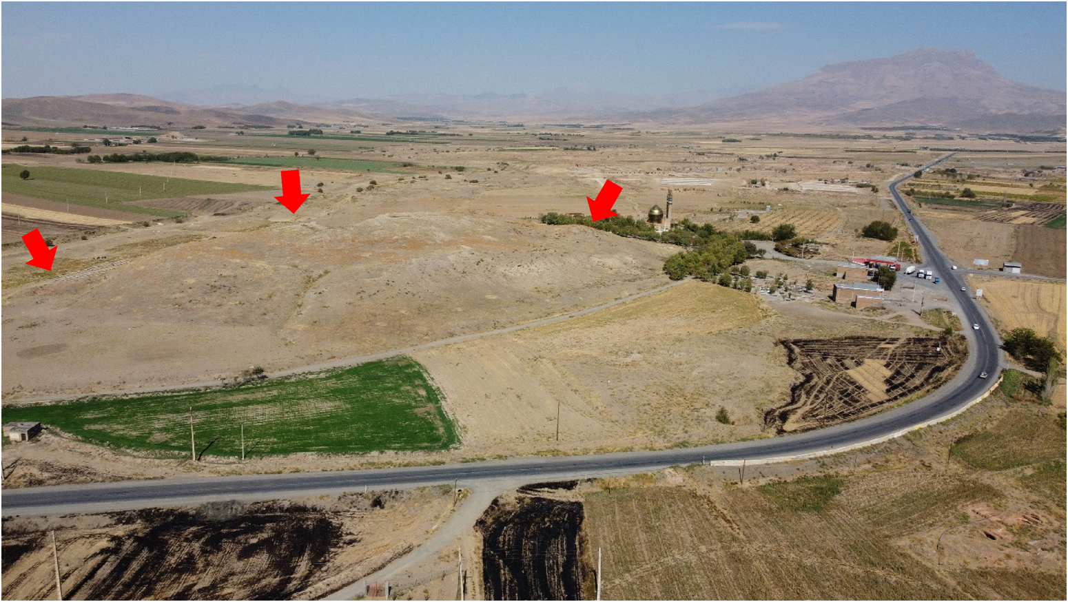
Aerial view of the Kangavar plain and Khan-Gormaz mount from the top of Godin Tepe (by Abbas Bavarsaee).

This research focuses on exploring the routes leading to the metropolis of Ecbatana (modern Hamadan), at the beginning of the ancient Upper Media, that is, in the present-day Kangavar-Asadabad plain. Therefore, other historical roads of this area, which extended to the south (Nahavand), or via the southeast route (Tuyserkan), after bypassing the heights of Alvand, reached Hamadan and the central regions of Iran, are excluded from this research. This study is mainly based on historical texts from different periods, supplemented by archaeological evidence and the region's geographical features.
Because the distances declared by old geographers are one of the main factors for locating ancient sites, an explanation of the parasang/farsakh and schoeni, two historical units of walking distance used in this study, is in order. It is understood that the Persian farsakh was the distance that could be walked in one hour.Footnote 2 Bivar, based on the Greek historian and geographer Herodotus’ information, calculated the size of the parasang in ancient Iran at about 5.3 km.Footnote 3 Regarding the distance between the cities of Kangavar and Asadabad, which is 35 km, and comparing it with the reports of geographers of the Islamic era, who declared the distance between these two cities as 7 farsakh, the author believes that the farsakh in the early and middle centuries of the Islamic era was also approximately equivalent to the same 5.3 km. However, the size of the farsakh unit in the late Islamic centuries, including the Qajar period, was about 6 km,Footnote 4 which shows that this quantity, at least over time, did not have a constant value. According to Pliny,Footnote 5 even the Persian writers themselves do not agree about the length of their schoeni and parasang, each assigning to them a different length. In the last two centuries, researchers have proposed different values for the schoeni. For example, of the earlier researchers, Masson has estimated the schoeni as 2.5 miles (4 km),Footnote 6 while Musil has placed it at 4.7 km.Footnote 7 Schoff considers the schoeni to be the same as the farsang and its value between 3.25 and 3.5 miles (5.2–5.6 km),Footnote 8 Geyer and Monchambert similarly calculated this unit as about 5–5.5 km,Footnote 9 and Schmitt put it at 5.5 km on average.Footnote 10
While it seems that contemporary researchers mostly agree on 5–5.5 km for each schoeni and consider it equal or very close to the ancient farsakh, the results of analysis of distances between the ancient places in this research, as well as the parallel research conducted by the author in the central Zagros region, interestingly confirm Masson's proposal for the size of the schoeni, at least in the case of the ancient Media. Therefore, the author has considered the old farsakh to be about 5.5 km on average and the schoeni to be about 4 km. However, determining the exact location of ancient places only based on their distance is difficult and often inaccurate because of various factors. For example, a review of ancient texts indicates that geographers at the time usually declared distances as a round number (integer), while of course not all distances are a whole number. For example, a place whose real distance was 2.7 or 3.4 schoeni or farsakh was likely recorded as 3 schoeni or 3 farsakh.
Another issue that modern researchers must consider is the identification of the origin and destination points, where the distances have been measured. In addition, for a more accurate evaluation of the distances, the details of the ancient road, such as direction, places (city, village, bridge, river), and its topography type (mountain, pass, plain, valley) are paramount. For example, it is obvious that a mountainous route such as Asadabad Pass or Bid-i Surkh Pass in the studied region, due to being impassable and its steepness, was often traveled in a spiral or zigzag manner. Therefore, it is certain that the distance traveled on such routes at a certain time, for example, during an hour or half a day, was significantly less than the total distance traveled at the same time on flat plains such as the Kangavar-Asadabad plain. Moreover, the old roads did not necessarily correspond to the modern roads, and sometimes even in a specific region, the road of one period is different from another. Therefore, in order to reconstruct old roads and locate ancient sites, the influence of various factors must be noted. In general, in this research, the author has assumed the historical monuments or sites in each city or place as the basis of distance measurement. For example, the Anahita temple boundary (Figure 3, no. 1), in the center of the current city, is assumed as the measuring point for the distances of different places from Kangavar (Concobar), where the result of the excavations of the Iranian delegation have revealed traces of historical and Islamic periods.Footnote 11 Similarly, the basis for evaluating the distance from Hamadan is assumed to be the Tapeh-ye Hagmatana (Figure 3, no. 22), in the center of the current city, and for the other investigated places, the measuring point has assumed to be their historical sites (if any).Footnote 12
For a better understanding of the ancient route and easier locating of the places along it, the historical texts have been meticulously reviewed from the new Qajar era to the old Parthian period.Footnote 13
Investigation of the Latter Islamic Texts (Safavid and Qajar Periods)
One of the most detailed historical descriptions of the Kangavar-Asadabad communication route is that of the Qajar king Naser al-Din Shah (1848–96), documented during his pilgrimage journey to the holy shrines of Atabat-i Aliyat in Iraq in 1870. Considering the interval between the Nasrid period and the present era, most of the places he mentions are still easily recognizable. During his journey, the king passed through Hamadan and entered the Asadabad plain, not via the Asadabad Pass, but via the Malhamdareh (modern Molhamdarreh) route, which, according to him, was a carriageway. Continuing southward, he mentioned Asadabad and the village of Badkhoreh on the left side, and the villages of Khakriz, Biaj castle, Chenar (today: Chenar-e Shaykh or Chenar-e Sofla), and Hesamabad on the right side of the road, although some of these were not directly adjacent to the road. He described the road as grassy, with low and high land and streams, unsuitable for carriage. As the king progressed through the Kangavar-Asadabad plain, he gradually approached the historical road. After crossing a three-arch bridge, he reached the village of Rahmatabad. He then mentioned the villages of Taherabad and Hosseinabad on the left side of the road and finally entered Kangavar.Footnote 14 In contrast to the mentioned villages, the exact location of the three-arch bridge is unknown. It is possible that the king in fact meant the four-arch bridge known as Pul-i Shekasteh (more on this below), which he mistakenly called a three-arch bridge, but this hypothesis cannot be proven.
A look at Naser al-Din Shah's route in Figure 3 indicates clearly that the king's route differs significantly from the present-day road and even from the historical road of Kangavar-Asadabad (Deh-Bozan route in Figure 3). Additionally, other Qajar texts mention another road (Deh-Bozan route) on the Kangavar-Asadabad plain, which appears to have been busier and older than the previously described route, closer to the current road. The most accurate description of the recent route is from a text by MacGregor in the late nineteenth century, which has also been repeated by Boyce:
At 4⅟2 miles cross low ridge and at 5⅟2 miles cross broad rocky rugged ridge, whence descend into another richly cultivated and populous valley extending to the foot of the lesser range of the Elwand Mountains. At 6⅟2 miles, cross small stream called Ser-i-ab-i-kherreh flowing down from village under hill about 1 mile off left of road called Jafferabad. At 8 miles pass small spring on right of road running in a stream down to village off that side called Deh-i-noosh. At 10 miles pass walled town about 2 miles off left called Beefooneh, and at 11 miles cross a deep pool of stagnant water called Sujahgur, by a fine brick-bridge of 4 arches in good repair. This bridge is built at right angles to the general direction of road, and is a good landmark. At 12⅟2 miles pass mound on left of road called Koosheh-Tuppeh, close by which rises a small stream of the same name. At 14 miles pass through large village of Vinderabad, the portion on right of road surrounded by ruined mud wall, within which is a lofty artificial mound; pass a spring on left of road, and at 15 miles pass large villageFootnote 15 off same side. At 16 miles pass through village of Deh-i-Boozan, there is another spring of water. From this, lines of Kanats lie alongside of road reaching to Assudabad.Footnote 16 At 17 miles pass small townFootnote 17 surrounded by poplar trees off left of road. At 18 miles a road branches off to right front, apparently leading direct to the main pass over the ElwundFootnote 18 mountain avoiding the town of Assudabad.Footnote 19
Notably, some of the toponyms mentioned in the text, such as Deh-i-noosh (Cheshmeh Nush), Beefooneh (Bifanj), Vinderabad (Vandarabad), Deh-i-Boozan (Deh-Bozan), and Koosheh-Tuppeh corresponds to the current Qooshak Tappeh, situated 600 meters north of the village of Valiabad. It is registered today as number 11362 in the National Heritage list of Iran (Figure 3, no. 19). Some of the villages and geographical features referenced in the text have either been abandoned or renamed, including Jafferabad (perhaps the current Golbudaq), Ser-i-ab-i-kherreh (i.e., mud spring), and Sujahgur, the last is likely the former name for the current Qarachai (a main tributary of the Shahab River).
Sometimes, other texts mention villages situated along this route not referenced by MacGregor or Boyes. For instance, Azod al-Mulk, who passed through this plain from Kangavar to Asadabad in 1866, refers to the village of Valiabad, located directly on this road.Footnote 20 Valiabad still stands today. Sayf ol-Dowleh, in 1862, mentions a river and a bridge located in the middle of the Kangavar-Asadabad road, one hour away from Kangavar.Footnote 21 Regarding Sayf ol-Dowleh's route, it is clear that the river he mentions is the current Shahab/Shah-Ab River, almost situated in the middle of the Kangavar-Asadabad road. Therefore, according to Sayf ol-Dowleh, and especially MacGregor and Boyes's descriptions, it seems that the historical bridge referred to is the same today, known as Pul-i Shekasteh-ye Khosrowabad (the broken bridge of Khosrowabad), registered as number 1875 in the National Heritage list of Iran as a building from the Safavid period (Figure 3, no. 6).
Hollingbery, who passed this route in 1801, over fifty years prior to Sayf ol-Dowleh, writes: “about five miles after Asadabad, we passed a road where several forts were visible on the right side. After proceeding 2–3 miles, we reached a small river with a six-arch bridge called Haji Ali Khan. The village of Kangavar was located 12 miles away from this bridge.”Footnote 22 About 140 years earlier, in 1664, French traveler Jean Thevenot, on his route from Kangavar to Asadabad, provides more details about the route and the aforementioned bridge. He writes:
We parted from Kenghever,Footnote 23 and in a very good road, marched northwards. Then we passed over a fair bridge of six arches, called the bridge of Sehick-Hali-Kan, from the name of a chan that founded it, the river that runs under it is called the water of Scheich-Hali-kan bridge, for to bridges they give the name of the founder, and to the waters that run under them the name of the bridge. About seven of the clock in the morning we came to a town called Asadabad.Footnote 24
It is also clear that the river referenced by Hollingbery and Thevenot is the current river of Shahab, as this river (and its main tributary, Qarachai), as an important geographical sign, is situated approximately 12 miles (11 miles according to MacGregor and Boyes) away from Kangavar (the distance between Pul-i Shekasteh and Anahita temple is about 19 km). Based on Thevenot's description, it seems that the name of the Shahab River in the Safavid era was Shaykh-āb, that is, the water of the shaykh. Apparently, the current name of the river (Shahab) is derived from that very name (Shaykh-āb). Furthermore, regarding the descriptions of Hollingbery and Thevenot, there is no doubt that the mentioned six-arch bridge is different from the four-arch bridge of Khosrowabad, known as Pul-i Shekasteh, mentioned by MacGregor and Boyes. In fact, it seems that the mentioned six-arch bridge was from the Safavid or an older period, which remained until the early Qajar period and then was replaced by Pul-i Shekasteh. Therefore, judging from historical texts, the construction date of Pul-i Shekasteh is not the Safavid period, as is stated in its registration file, but is the Qajar period, probably the Nasrid era.
Shaykh Alikhan, to whom the six-arch Safavid bridge is attributed, was the grand vizier (prime minister) of Shah Suleiman I of Safavid (1666–94), and was originally from the Zanganeh Kurdish tribe in Kermanshah.Footnote 25 Numerous structures throughout Iran, especially in present-day Hamadan and Kermanshah provinces, are attributed to Shaykh Alikhan, including the inscription known as “waqf-nameh-ye Shaykh Alikhan” in Bisotun, engraved on the relief of Mithridates II.Footnote 26 Overall, according to historical texts, the recently discussed Deh-Bozan route was the most traversed historical route on the Kangavar-Asadabad plain across various periods. Regarding the location of some places, such as the bridge of Pul-i Shekasteh and the village of Valiabad, which were located right along this route, it can be concluded that the mentioned old route was situated on the east of today's road.
Investigation of the Early and Middle Islamic Texts
Although the information about the Kangavar-Asadabad route obtained from the early Islamic historical and geographical texts is somewhat vague and often without any details, they include important information about some unknown ancient buildings along the route. The most detailed description of this route in early Islamic texts belongs to Ibn-Rustah Isfahani (fl. tenth century), who writes: “From Qaṣr al-luṣuṣ to Khondad is seven farsakh. The road is full of ups and downs and the area is scary, because the area around is the residence of bandits. Then the road leads to fields and farms. It crosses a bridge. There is an Iwan built by Khosrow known as Iwan al-Ṣanj. Then the road continues from here to Khondad.”Footnote 27 We know that during the early and middle Islamic centuries, Qasr al-Lusus (the palace of thieves) was an alternative name for Kangavar.Footnote 28 The bridge referred to in this account was likely located on the current Shahab River near the current village of Khosrowabad. In this case, it is possible that the bridge in question by Ibn-Rustah is the same six-arch bridge mentioned by the travelers of the Safavid period, or more likely, it is a separate and older bridge. The name of Iwan al-Sanj is only seen in the Ibn-Rustah text. The appellation of the name, and the exact location of Iwan al-Sanj,Footnote 29 is not specified by the text. This building was probably located somewhere in the area of present-day Khosrowabad or Valiabad.
Another account is provided by Abu Dulaf (d. 950), who writes: “Maṭbakh-i Kasrā is a big building in the middle of the desert, located four farsakh from Qaṣr al-luṣuṣ [Kangavar] and three farsakh from Asadabad, and there are no settlements around it. Pirouz used to go to Qaṣr al-luṣuṣ and his son, Shah Mardan, went to Asadabad. At meal time, the servants delivered food hand to hand from this place (the kitchen) to the king and his son in Qaṣr al-luṣuṣ and Asadabad.”Footnote 30 The story of Matbakh-i Kasra (Farsi: Ashpazkhaneh-ye Khosrow, i.e., Khosrow's kitchen) has been mentioned in some other sources too.Footnote 31 Minorsky believed that both buildings of Matbakh-i Kasra and Iwan al-Sanj, mentioned by Abu Dulaf and Ibn-Rustah, probably refer to a building in current Minderabad (Vandarabad).Footnote 32 However, regarding the distances of the mentioned building from Kangavar (4 farsakh, approx. 22 km) and Asadabad (3 farsakh, approx. 17 km), the author thinks that Tapeh-ye Khosrowabad (Figure 3, no. 3) and Qooshak Tappeh of Valiabad (Figure 3, no. 19), which are approximately located in the same position, are the most appropriate and possible options for locating the building known as Matbakh-i Kasra. As Minorsky believes, probably Matbakh-i Kasra and Iwan al-Sanj were different names for a building.
Al-Maqdisi (d. 991) mentions another building called Iwan-i Kisra, 1 farsakh away from Asadabad,Footnote 33 though considering its distance from Asadabad, it seems to be a different and independent building from the previous ones. In addition, Ibn-Faqih Hamadani (fl. tenth century), and following him, Yaqut al-Hamawi (d. 1229), write: “Khosrow [surname of the Sasanian kings] built numerous buildings from Madaʾin to Azarmidukht in Asadabad, but did not advance beyond the Asadabad Pass.”Footnote 34 We know that Azarmidukht (d. 631) was one of Khosrow Parviz's daughters, who ruled for a short time. However, there is no information about the location of “Azarmidukht” in the Asadabad area, cited for the first time in the abovementioned text, nor about its relation to the mentioned Sasanian king. (I will speculate about the location of Azarmidukht and Iwan-i Kisra in the “Adrapana/Ἀδραπάνα(ν)” section below.)
Investigation of the Pre-Islamic Texts: The Image of Upper Media in Isidore's Narrative
The Parthian Stations of Isidore of Charax (end of 1 BC–beginning of AD 1) is one of the most important sources for reconstructing the historical geography of the areas along the ancient Silk Road (Great Khorasan Road) within the territory of the Parthian Empire (247 BC–AD 224). So far, various options, such as being a trade route or a military route, have been suggested for the function of the Parthian Stations.Footnote 35 According to Isidore (chap. 6), after passing the area of Cambadene, there was the area of Upper Media, which extended 38 schoeni. In this area, in addition to the city of Concobar and the metropolis of Batana, there were five other smaller stations, two of which (Bazigraban and Adrapana) have been mentioned by Isidore. Scholars rightly agree that Concobar is the same modern city as Kangavar, in the middle of the road from Kermanshah to Hamadan.Footnote 36 Batana, which Isidore referred to as the metropolis of Media, corresponds with Ecbatana in other Greek texts, Hagmatana in the Achaemenid inscriptions, and modern Hamadan.Footnote 37 According to Isidore, Concobar was located 3 schoeni from the border of Upper Media. If we assume the schoeni, based on Masson's opinion, to be about 4 km, then this border exactly corresponds to the west heights of Kangavar, between the modern cities of Sahneh and Kangavar, which is known today as Bid-i Surkh Pass (Gardaneh-ye Bid-i Surkh).
Therefore, it seems that the western slope of the Bid-i Surkh heights can be considered as a terminal station of the ancient Cambadene, while the eastern slope, near the modern city of Kangavar, can be considered as the beginning point of Upper Media. It should be noted that the name “Upper Media” is not mentioned in any Islamic source. In the so-called Tabula Peutingeriana map, which depicts the global road network of the Roman period,Footnote 38 the very amazing form of “Madobalani” is seen, which, according to the author, corresponds to the Iranian term “Mad-i Bala.” This means that the Greek phrase “Μηδία ή ἄνω” in the Parthian Stations of Isidore is in fact a translation of the Iranian title “Mad-i Bala.” On the Tabula Peutingeriana, places such as Concobas and Beltra are seen in the region of Madobalani, which appear to be within the scope of this research. Beltra will be discussed in the “Adrapana/Ἀδραπάνα(ν)” section below, but as other researchers believe,Footnote 39 it is most likely that Concobas is the same Concobar of Isidore's text (present-day Kangavar).
Isidore mentions three stations within the initial part of Upper Media, corresponding to the current Kangavar-Asadabad plain: Concobar, Bazigraban, and Adrapana, respectively, from west to east. Here, I investigate the two toponyms of Bazigraban and Adrapana.
Bazigraban (Βαζιγράβαν)
According to Isidore, after Concobar, the second station was the customs house of Bazigraban, situated 3 schoeni (approx. 12 km) beyond Concobar, on the route to Ecbatana. The important characteristic of Bazigraban, which distinguishes it from the previous stations of the Zagros region, was its identification as a customs house. Since the nineteenth century, scholars have linked the first part of this name (bāz) to the Old Persian bāği, meaning tribute.Footnote 40 Brunner believes that the name of this place (from the Old Persian *bajī-gṛbana) reflects its function as a customs house.Footnote 41 Daryaee suggests that it is possible to read this as wāzarg-bān, “merchant guard,” or simply the term for a merchant, wāzargān/bāzargān, from the Pahlavi wāzār, Persian bāzār, and now English bazaar or market.Footnote 42 Regarding the fact that the region was not located on the border of any country or area, but in the interior of the country (the Parthian Empire), the function of Bazigraban as a customs house is questionable.Footnote 43 One hypothesis is that Bazigraban was not a customs house but a place where road tools were collected.Footnote 44 It may be assumed that one good reason for the existence of a tool station in this area was for entering the metropolis of Ecbatana. In this case, the question arises as to why the station was not located in a closer position to Ecbatana; for example, in Adrapana.
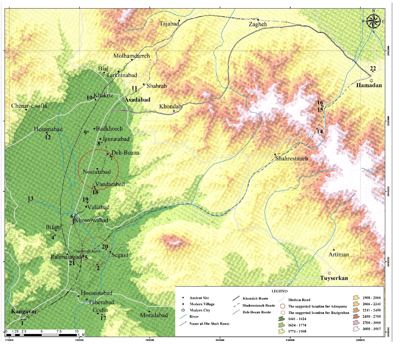
Regarding the fact that Bazigraban was 3 schoeni (approx. 12 km) from Kangavar, the author believes that this station was located exactly at the intersection of a multiway, where the caravans were able to choose one of several routes toward Ecbatana. As can be seen in Figure 3, I have determined the range of the Bazigraban in a circle with a diameter of 4 km (approx. 1 schoeni). The result of this analysis indicates that Bazigraban was most likely located somewhere around the southern part of the current Shahab River (Qarachai), before its joining the Khorramrud River. Here there are some historical sites, including Cheshmeh Nush (Figure 3, no. 5) and Tapeh Segavi D (Figure 3, no. 20), which have a Parthian layer. Although Cheshmeh Nush is considered our first proposed option, which of the sites in this area was the Bazigraban station can only be determined by archaeological excavations.
As Figure 3 indicates, in the author's suggested location for Bazigraban, the ancient road is divided into several branches as follows:
1. The short northeastern route, about 70 km (from Kangavar to Hamadan), which links the western slopes of Alvand to Hamadan (Ecbatana) on the eastern slope of this mountain (the Shahrestaneh route in Figure 3). This route passes the present village of Segavi and the winding valley of Shahrestaneh (or Tarik-Darreh valley). The existence of two well-known cuneiform inscriptions from Achaemenid kings, known as Ganjnameh (Figure 3, no. 15),Footnote 45 at the end of this route highlights the significance of the Shahrestaneh route in the first millennium BC. In addition, remnants of an ancient rock-cut road have been reported from the end of this valley (Figure 3, no. 14).Footnote 46 The existence of some archaeological evidence such as clinky sherds found from around this rock-cut road (Figure 3, no. 14), as well as a rock relief in the northwest of Ganjnameh attributed to the Parthian period (Figure 3, no. 16),Footnote 47 indicates that the Shahrestaneh route was also used during the Parthian era. In some parts of this ancient road, the height reaches more than 2,600 m above sea level, which indicates that this road was most likely passable only during the warm seasons when the weather conditions were favorable.
2. The second route, which I have called the Deh-Bozan route, continued northward via the current village of Khosrowabad, bypassing the Shahab River and northwestern heights of the Alvand mountains, before finally reaching Ecbatana (Hamadan). This route, which was apparently the same as Isidore's intended route, is longer but easier than the Shahrestaneh route.
3. The road that went toward the northwest and coincides with the Naser al-Din Shah route (Figure 3). This route eventually reached Hamadan via Malhamdareh in the western part of Asadabad. It was a longer route but had a lower altitude and therefore was suitable for winter.Footnote 48
The author believes that the location of Bazigraban at the intersection of a multiway road leading to the metropolis of Ecbatana was the most important reason for the presence of a tool station here. However, it is possible that other factors such as security were influential in this subject. In fact, despite the importance of the Kangavar-Asadabad plain from a political-economic-military aspect, as historical sources mention, it has always had problems in terms of security. As mentioned, Ibn-Rustah has reported about the danger of thieves in this region in the early Islamic period. In addition, in the various texts of the early Islamic period, Kangavar is mainly known as Qasr al-Lusus (the palace of thieves). Also, according to accounts by various travelers passing through the region between the Bid-i Surkh and Asadabad passes, security was cited as the main concern of all travelers until the Qajar period. In such a situation, it is not unlikely that those living in passes lay in wait for travelers and, if they did not plunder them, they at least demanded a transit fee for the safe passage granted.Footnote 49 Therefore, it is possible that one of the reasons for the presence of a toll station in this place was to collect money from travelers in exchange for guaranteeing their safety to pass along the path that led to dangerous mountain valleys and passes in all directions.
It should be noted that among previous scholars, Masson read this toponym as Maziniaman and located it on the Rahdari station between Asadabad and Kangavar.Footnote 50 However, the exact location of the Rahdari station is not recognizable today, but it was probably located somewhere close to the place suggested by the author. Tomaschek believed that Bazigraban was the same monument, the so-called Matbakh-i Kasra,Footnote 51 but regarding the distance between Bazigraban and Kangavar (3 schoeni, approx. 12 km), and the distance between Matbakh and Kangavar (4 farsakh, approx. 22 km), it is clear that these two places cannot be the same. Weissbach located Bazigraban in Muradabad (Moradabad of Tuyserkan?).Footnote 52 Jackson and Herzfeld located Bazigraban in modern Asadabad.Footnote 53 Brunner located Bazigraban in Manderabad (Vandarabad)Footnote 54 and Muñoz located this toponym in Khorsabad (Khosrowabad?).Footnote 55 However, regarding the distance of 3 schoeni between Bazigraban and Concobar and my suggestion for the ancient road's path, the previous suggestions for the location of Bazigraban in Asadabad and Vandarabad (Manderabad) are not tenable.
Adrapana/Ἀδραπάνα(ν)
Adrapana was the third station in the region of Upper Media, after Concobar and Bazigraban, which was located on the way to Ecbatana (modern Hamadan), at a distance of 7 schoeni after Concobar and 12 schoeni before Ecbatana. According to Isidore (chap. 6), in Adrapana there were the remains of a royal residence of those who ruled in Ecbatana, which was destroyed by Tigranes the Armenian (95–55 BC).Footnote 56
So far, various scholars have commented on the appellation and location of Adrapana. Masson read this toponym as Adragiananta and accordingly suggested a root (“Little Town”) for it.Footnote 57 Rawlinson, and following him, Schoff and Debevoise, located Adrapana in modern Artiman, near the city of Tuyserkan.Footnote 58 Other scholars have located Adrapana mainly along the road of modern Asadabad; for example, Masson located it in the villages of Karkhana and Minderabad,Footnote 59 Tomaschek, and subsequently Azkaei, located Adrapana in Asadabad,Footnote 60 while Ahadian has located this toponym in Tapeh Khakriz in Asadabad (Figure 3, no. 10).Footnote 61 It should be mentioned that the 7 schoeni between Concobar (Kangavar) and Adrapana, in terms of quantity, is reminiscent of the 7 farsakh between Kangavar and Asadabad in the Islamic geographic texts.Footnote 62 Regarding this and the fact that Asadabad was the most famous place between Kangavar and Hamadan, at least during the Islamic era, we may conclude that Asadabad is a suitable option for locating Adrapana. However, this requires that we assume farsakh and schoeni to be equal in measure, while this is not the case; otherwise, regarding the 12 schoeni between Adrapana and Ecbatana, geographers should also have considered the distance between Asadabad and Hamadan as 12 farsakh, while this distance has been mentioned as 9 farsakh.Footnote 63 If we were to assume farsakh and schoeni to be equal and consider each schoeni about 5.3 km, then the 12 schoeni between Adrapana and Ecbatana would be about 64 km, which also does not match with the distance between Hamadan (the Parthian site) and Asadabad. In fact, the distance between Hamadan and Asadabad via the longer present-day road is about 50 km, while the ancient road, which we are familiar with by the early Islamic sources,Footnote 64 was at least 10 km shorter than the modern road.
Regarding the location of Adrapana, Aziz is hesitant about the connection between Adrapana and Asadabad.Footnote 65 Although Knapton and his colleagues, in searching for the origin of several Achaemenid column bases discovered in Hamadan, have mentioned the Adrapana palace, they did not locate this toponym.Footnote 66 Dolens and Khatch believed that Adrapana was the capital of Atropatene and the same subsequent Khondad in the texts of old Arab geographers.Footnote 67 However, as Schmitt posits, Adrapana has no relation with the famous area of Ἀτροπατίαν.Footnote 68 In addition, the result of recent research indicates that Khondad in Islamic texts corresponds to the modern Khondab, located 10 km east of Asadabad. Khondad was an independent short route for passing through the northwestern heights of the Alvand mountains during different eras, especially in the early Islamic period.Footnote 69
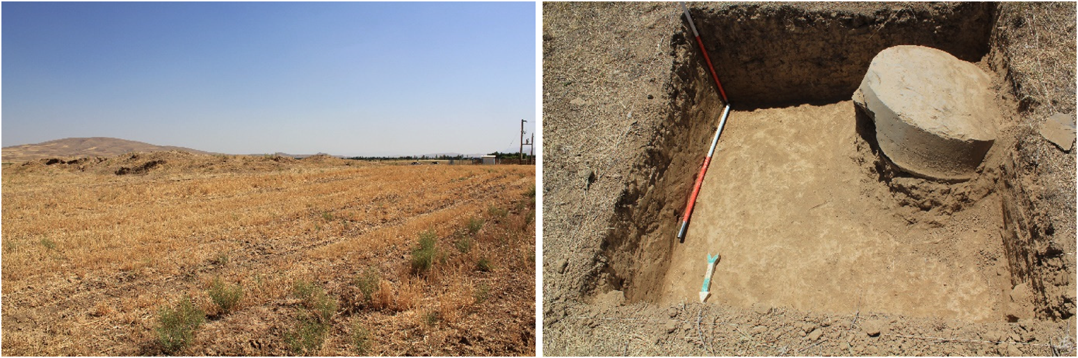
The variety of suggestions indicates the lack of consensus on the location of Adrapana. As can be seen in Figure 3, the author's suggested route for the ancient road from Bazigraban to Adrapana is situated to the east of the modern road and passes near the ancient sites in the region. Regarding the 4 schoeni (approx. 16 km) between Bazigraban and Adrapana, as well as the 7 schoeni (approx. 28 km) between Concobar and Adrapana, this distance corresponds to the current village of Deh-Bozan,Footnote 70 situated about 8 km south of Asadabad along the eastern side of the Kangavar-Asadabad road. In 1986, artifacts including fragments of five Tori and three undecorated bell-shaped column bases, made of polished black calcareous stone, were discovered during a road construction in Deh-Bozan.Footnote 71 A subsequent excavation in 2013 unveiled the remains of another broken column base from the same place (Figure 2).Footnote 72 In general, Huff and Mousavi believe that these column bases are very similar to the bell-shaped column bases of the Achaemenid period.Footnote 73 Mehryar and Mousavi also consider the building of Deh-Bozan as an Achaemenid station, while Mehryar and Kabiri propose it to be Bazigraban.Footnote 74
A view of Tappeh Deh-Bozan and a column base discovered from the 2013 archaeological excavation (courtesy of Yaghoub Mohammadifar).

The suggested location for Adrapana has been specified in Figure 3. The author believes that Deh-Bozan (Figure 3, no. 7) corresponds to the Adrapana station, which was a caravan stopover, and its discovered artifacts, regardless of their dating, belong to the Adrapana station. Additionally, it is possible that the ruins in Deh-Bozan are of the same building that al-Maqdisi referred to as Iwan-i Kisra,Footnote 75 located 1 farsakh from Asadabad. Consequently, the author suggests that Adrapana palace should be searched in the current village of Vandarabad, about 5 km south of Deh-Bozan. This suggestion is based on the phonetic similarity between Vandarabad and Adrapana, as well as the discovery of a column base in Vandarabad. Unfortunately, this column base was not discovered in an archaeological excavation, and accordingly, it is difficult to comment on its original site or building. An excavation in 2011 at the ancient mound of Vandarabad (Figure 3, no. 18) revealed it was settled from the Bronze Age to the Sasanian era.Footnote 76 Therefore, regarding the size and quality of this mound, it is possible that the mentioned column base was obtained from the same site.
Suggested locations for ancient routes and toponyms in the Kangavar-Asadabad plain (by Abbas Bavarsaee).

Since the nineteenth century, a common idea has associated the name Adrapana with the sacred fire. Tomaschek considered it “protected by fire.”Footnote 77 Brunner believes that if the name derives directly from the Old Persian *ātṛpāna, “having the protection of [the divine] Fire,” then this place held some significance in the Achaemenid state cult.Footnote 78 As noted, Ibn-Faqih mentions a place called Azarmidukht in Asadabad. Considering the similarity of the first part of the names, both containing Azar/ātṛ (fire), it is possible that Azarmidukht is a distorted form of Adrapana.
In general, although Isidore did not mention the construction date or founder of the Adrapana palace, assuming an Achaemenid or post-Achaemenid dating to the building (Seleucid or the beginning of the Parthian period) and regarding its destruction in the first half of the first century BC, it seems that the ruins of Adrapana palace were still visible during Isidore's era.
Finally, Tomaschek believed that “Beltra,” which is located after Concobas (Concobar, Kangavar) on the Tabula Peutingeriana, corresponds to Adrapana in Isidore's text, as well as Khondab in Islamic texts.Footnote 79 He also interpreted the name Beltra to mean “protected by Bel” and related it to the Iranian name “Bé-dukht” (Bidukht).Footnote 80 Based on the phonetic similarity, it is possible that Beltra and Bidukht coincide with the site of Badkhoreh (Figure 3, no. 9) on the road from Kangavar to Hamadan, near the proposed place by Tomaschek.
Conclusion
In this research, the author identified some ancient routes in the Kangavar-Asadabad plain leading to Ecbatana (Hamadan), based on which he located several old toponyms along these routes mentioned by Isidore of Charax and some Muslim geographers. The examination of historical and geographical texts of the last two thousand years indicates that only a few important places such as Hamadan and Kangavar have maintained, more or less, their importance for a long time and their names have been mentioned continuously in texts of different periods, and other places of the studied region have appeared temporarily in texts of a certain period and then suddenly disappeared. This issue has caused us to encounter in geographical texts a set of different and non-repeating toponyms belonging to this 30–40 km route (Kangavar-Asadabad plain) that apparently bear no relation to each other. The author believes that the reason was not the destruction of previous places, or the changing of their names, but the growth and prosperity of nearby places, as a result of which, declining places were replaced by developed places along the same route. A notable example of this discussion is the existence of several places close to each other in the northern part of the Kangavar-Asadabad plain, including Asadabad, Badkhoreh, Khondab, Deh-Bozan, and Vandarabad, each of which seems to have had a pivotal role during a special period in the northern part of the studied area. For example, Deh-Bozan and Vandarabad (Adrapana) in the Parthian period, probably Badkhoreh (Beltra?) in the Sasanian period, Khondab (old Khondad) in the early Islamic centuries, and Asadabad in many periods of the Islamic period were the most important places in this area. In fact, it seems that many of the old places located along this route still exist today as small villages and have preserved their ancient names, sometimes with little changes in appearance, among which we can mention Vandarabad (probably old Adrapana), Khondab (old Khondad), and Badkhoreh (perhaps Beltra).
The author believes that the customs house of Bazigraban was located at the beginning point of a multiway road, somewhere around the current village of Cheshmeh Nush to the western part of Segavi (Seh Gabi). All these branches eventually led to Ecbatana (modern Hamadan). Also, the author holds that the Adrapana station corresponds to the present village of Deh-Bozan, while the palace of Adrapana was located in Vandarabad, south of Deh-Bozan, and the name of current Vandarabad is, most likely, rooted in the ancient name of Adrapana. It seems that after leaving Adrapana station (Deh-Bozan), there were several possible options to continue the ancient road to Hamadan.Footnote 81 In the meantime, the Asadabad Pass (Gardaneh-ye Asadabad) is, at least today, the most important communication route between Hamadan and Kermanshah.
Regarding the 12 schoeni (approx. 48 km) between Adrapana station and Ecbatana, it seems that Isidore's intended route passed through the Asadabad Pass via the Imamzadeh Abdullah road and the current village of Zagheh, because it corresponds exactly to the distance between Deh-Bozan and the Parthian settlement of Ecbatana. Although Isidore did not mention any stations on this route, it is very likely that at least one of the five small stations located in the region of Upper Media, three of which were not described by him, was located on this route. Perhaps the column base found in Imamzadeh Abdullah (Figure 3, no. 11), 1 km northeast of Asadabad, belongs to one of these stations. According to the Russian Cherikov, on his visit to Asadabad in 1848, he saw two broken marble columns in the house of the Asadabad ruler; while it was not clear where they were brought from, he believed that they were made of marble from the mine of the same place.Footnote 82 It is possible that these columns belonged to the Imamzadeh Abdullah building or even Adrapana buildings. According to historical texts, the route of Asadabad-Imamzadeh Abdullah, which passed near the present village of Shahrab, was one of the main ways of passing the northwestern heights of the Alvand mountains and reaching Hamadan.Footnote 83
As all the discovered column bases can be classified as Achaemenid, it seems that the mentioned stations were built in the Achaemenid period along the royal road and have also preserved their function during Seleucid and Parthian times. The result of this research indicates that the ancient road on its way to Ecbatana (Hamadan) on the current Kangavar-Asadabad plain had branches, the use of which largely depended on weather and seasonal conditions. Therefore, it seems that in winter the two high and snowy passes of Shahrestaneh and Asadabad were replaced by lower routes such as Malhamdareh. Undoubtedly, future targeted excavations on this route could provide new clues about the settlements located along the ancient road of the Kangavar-Asadabad plain.
Acknowledgements
I would like to express my profound thanks to Professor Daniel Thomas Potts for his useful comments and for sending some related sources. I would also like to thank Dr. Rojwan Zahedi for his help in editing the English version of the article. Additionally, I am grateful to Dr. Yaghoub Mohammadifar for providing the images of the Deh-Bozan's column base and to Abbas Bavarsaee for his assistance in preparing Figure 3.