INTRODUCTION
Among depositional environments, estuarine systems can elucidate continental and marine influences that have occurred in the recent past. Assessing sedimentological records in conjunction with the geochemistry can elucidate environmental changes that have occurred since the last glaciation (Lamb et al. Reference Lamb, Wilson and Leng2006; Uéara et al. Reference Uéara, Duleba, Petri, Mahiques and Rodrigues2007). Micropaleontological data can reveal environmental changes that help us better understand the past of these environments (McCarthy et al. Reference McCarthy, Tiffin, Sarvis, McAndrews and Blasco2012; Wartenberg and Freund Reference Wartenberg and Freund2012; Miller et al. Reference Miller, Leroy, Izon, Lahijani, Marret, Cundy and Teasdale2013; Sobrino et al. Reference Sobrino, García-Moreiras, Castro, Carreño, de Blas, Rodríguez, Judd and García-Gil2014).
Relative sea level changes alter sedimentation and distribution patterns of organisms living in coastal environments, especially in estuaries (Pereira et al. Reference Pereira, Chaves and Santos2007; Souza et al. Reference Souza, Vidal-Torrado, Tessler, Pessenda, Ferreira, Otero and Macías2007). Sedimentological, biological, and geochemical analyses of sedimentary deposits used in conjunction (Drago et al. Reference Drago, Freitas, Rocha, Moreno, Cachao, Naughton, Fradique, Araujo, Silveira, Oliveira, Cascalho and Fatela2004; Lahijani et al. Reference Lahijani, Tavakoli and Hosseindoost2007; Trog et al. Reference Trog, Höfer, Frenzel, Camacho, Schneider and Mäusbacher2013) can form a complete historical reconstruction of an estuary. Each proxy complements the others, thus multiproxy gives greater credibility to these paleoenvironmental reconstructions (Goodman et al. Reference Goodman, Reinhardt, Dey, Boyce, Schwarcz, Sahoglu, Erkanal and Artzy2008; Trog et al. Reference Trog, Höfer, Frenzel, Camacho, Schneider and Mäusbacher2013; França et al. Reference França, Alves, Castro, Cohen, Rossetti, Pessenda, Lorente, Fontes, Buso, Giannini and Francisquini2015; Mourelle et al. Reference Mourelle, Prieto, Pérez, García-Rodríguez and Borel2015). This is especially true when the actual sea level oscillations are still subject to discussion (Angulo and Lessa Reference Angulo and Lessa1997; Martin et al. Reference Martin, Bittencourt, Dominguez, Flexor and Suguio1998, Reference Martin, Suguio, Dominguez and Flexor1997, Reference Martin, Suguio, Flexor and Archanjo1996; Martin Reference Martin2003).
Limitations in the determination of eustatic sea-level curves exist, with divergent or erroneous interpretations often based on poorly used techniques (Lessa and Angulo Reference Lessa and Angulo1998). Unanswered questions, such as when sea level reached the current level in postglacial transgression and the duration and scope of this transgression (Baker and Haworth Reference Baker and Haworth2000; Lewis et al. Reference Lewis, Sloss, Murray-Wallace, Woodrofee and Smithers2012) are the motivation for these investigations.
Unlike models applied to the Northern Hemisphere, the model proposed by Milne et al. (2005) for South America indicates that there was a rapid rise in sea level (rates around 7–8 mm/year) in the Early Holocene. This corresponds with the last deglaciation water pulse that occurred between ~8400 and ~7000 cal BP (Clark et al. Reference Clark, Marshall, Clarke, Hostetler, Licciardi and Teller2001). Around 7000 cal BP, there was a reduction of this rate until sea level reached its maximum; the subsequent fall in relative sea level intensified 5000 years ago (Milne et al. Reference Milne, Long and Bassett2005).
The relative fluctuations of sea level in Brazil during the Late Holocene are still subject to discussion (Angulo and Lessa Reference Angulo and Lessa1997; Lessa and Angulo Reference Lessa and Angulo1998; Martin et al. Reference Martin, Bittencourt, Dominguez, Flexor and Suguio1998, Reference Martin, Fournier, Mourguiart, Sifeddine, Turcq, Absy and Flexor1993; Martin Reference Martin2003; Angulo et al. Reference Angulo, Lessa and Souza2006). Studies by Martin et al. (Reference Martin, Fournier, Mourguiart, Sifeddine, Turcq, Absy and Flexor1993) and Martin (Reference Martin2003) have shown that the Brazilian east coast has been submerged for the last 7000 years, with a maximum depth around 5100 BP (5600 cal BP), 5 m above the current average sea level. However, subsequent coastal submersion was interrupted by two important coastal emergence phases: one at 4300–3500 cal BP and another at 2700–2100 cal BP. Another interpretation presented by Angulo and Lessa (Reference Angulo and Lessa1997), Lessa and Angulo (Reference Lessa and Angulo1998), and Angulo et al. (Reference Angulo, Lessa and Souza2006) suggests a gentle decline in sea level along the Brazilian east coast since the end of the transgressive Holocene maximum, not supporting the existence of secondary oscillations. In this scenario, this period is characterized by elevated sea level until 5000–5800 cal BP, when it reached maximum height, followed by a decrease to the present sea level (Angulo et al. Reference Angulo, Lessa and Souza2006).
From a sedimentological and stratigraphic point of view, estuaries represent important features formed during the transgression. In the past, estuaries occurred under transgressive conditions, interspersed between fluvial (below) and marine (above) deposits in the context of incised valleys. As the estuary evolves and sea level rise slows down, its transgressive characteristics are lost; the facies migrate into the bay (Rossetti Reference Rossetti2008). Estuaries could thus be considered ephemeral features that tend to be filled and eventually disappear when rates of sea level rise decrease (Lessa Reference Lessa2005).
Changes in the relative sea level have altered sedimentation patterns in mangrove areas, resulting in changes in the distribution of geochemical records in the sediment, organism and organic matter samples (Pereira et al. Reference Pereira, Chaves and Santos2007). The carbon/nitrogen (C/N) ratio can be used to differentiate between continental and marine sources of organic matter in sediments and is therefore a good indicator for paleoenvironmental reconstructions of coastal deposits (Meyers Reference Meyers1994; Drago et al. Reference Drago, Freitas, Rocha, Moreno, Cachao, Naughton, Fradique, Araujo, Silveira, Oliveira, Cascalho and Fatela2004; Carvalho et al. Reference Carvalho, Mendonça Filho and Menezes2006; Lamb et al. Reference Lamb, Wilson and Leng2006; Lahijani et al. Reference Lahijani, Tavakoli and Hosseindoost2007; Pereira et al. Reference Pereira, Chaves and Santos2007; Perez-Arlucea et al. Reference Perez-Arlucea, Alvarez-Iglesias and Rubio2007; Uéara et al. Reference Uéara, Duleba, Petri, Mahiques and Rodrigues2007; Medeanic et al. Reference Medeanic, Torgan, Clerot and dos Santos2009; Van Soelen et al. Reference Van Soelen, Brooks, Larson, Sinninghe Damsté and Reichart2012).
The analysis of shells and other micropaleontological proxies refine those interpretations (Martínez et al. Reference Martínez, Mahiques and Burone2013; Murray-Wallace and Woodroffe Reference Murray-Wallce and Woodroffe2014). For example, palynomorphs are commonly found with high levels of preservation both in reducing environments, such as saline water with low microbial activity, and in low-energy environments such as swamps, lakes, delta plains, estuaries, and continental shelves (Traverse Reference Traverse2008). These elements allow the inference of changes in vegetation resulting from climatic events or anthropogenic changes in the landscape (Flantua et al. Reference Flantua, Hooghiemstra, Vuille, Behling, Carson, Gosling, Hoyos, Ledru, Montoya, Mayle, Maldonado, Rull, Tonello, Whitney and González-Arango2016). According to Salgado-Laboriau (Reference Salgado-Laboriau2001), continental palynomorphs (pollen grains and spores) are transported and preserved in reducing environments and may suffer mechanical damage. Marine palynomorphs (foraminiferal linings, dinoflagellate cysts, and schaeocodonts), when found in estuarine and/or coastal environments, provide an indication of marine influence in that study area (Stancliffe Reference Stancliffe1996; Pienkowski et al. Reference Pienkowski, Mudie, England, Smith and Furze2011).
This study used a multiproxy approach to investigate the response of the coastal environment to oscillations in relative sea level during the Holocene. Our aim is to evaluate how a marine transgression during the Holocene took place in a particular estuarine coastal bay environment (Vitoria Bay, southeast Brazilian coast), a rocky coast with low sedimentary input and with coastal Quaternary deposits either limited or nonexistent.
CONTEXT OF THE STUDY AREA
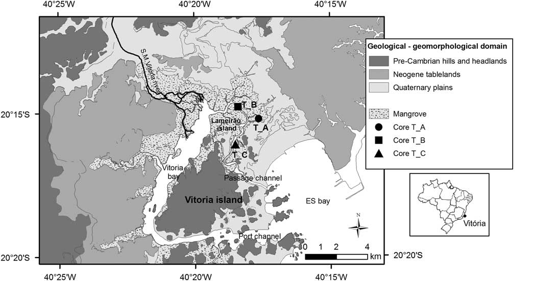
Vitoria Bay is located on the south-central coast of the state of Espírito Santo (ES), in the southeast region of Brazil, in a tropical humid climate environment. The coast is characterized by alternating layers of pre-Cambrian (Proterozoic and Paleozoic) rocky promontories (granite/gneiss) from the Paraíba do Sul Complex and Tertiary (Neogene) tablelands from the Barreiras Formation (Martin et al. Reference Martin, Suguio, Flexor and Archanjo1996, Reference Martin, Suguio, Dominguez and Flexor1997). Coastal plains are spatially limited or nonexistent, with their sedimentary evolution associated with sea level fluctuations and the availability of fluvial sediments (Albino et al. Reference Albino, Girardi and Nascimento2006). Quaternary records are characterized by fluvial-marine sands with mangrove areas limited by relief (Machado et al. Reference Machado, Albino, Leal and Bastos2016; Figure 1). Research regarding the evolution of coastal Quaternary deposits has been limited to a few studies (Martin et al. Reference Martin, Suguio, Flexor and Archanjo1996; Bastos et al. Reference Bastos, Vilela, Quaresma and Almeida2010; Machado et al. Reference Machado, Albino, Leal and Bastos2016). Exceptions are the studies along the north coast of the state, around the mouth of the Doce River (Suguio and Martin Reference Suguio and Martin1981; Dominguez et al. Reference Dominguez, Bittencourt and Martin1983, Reference Dominguez, Bittencourt and Martin1981; Martin et al. Reference Martin, Suguio, Flexor and Archanjo1996, Reference Martin, Fournier, Mourguiart, Sifeddine, Turcq, Absy and Flexor1993; Hatushika et al. Reference Hatushika, Silva and Mello2007; Cohen et al. Reference Cohen, França, Rossetti, Pessenda, Giannini, Lorente, Buso, Castro and Macario2014; France et al. Reference França, Alves, Castro, Cohen, Rossetti, Pessenda, Lorente, Fontes, Buso, Giannini and Francisquini2015; Rossetti et al. Reference Rossetti, Polizel, Cohen and Pessenda2015). Palynological surveys were previously limited to estuarine systems located in the northern region of ES state (Buso et al. Reference Buso, Pessenda, de Oliveira, Cohen, Giannini, Schiavo, Rossetti, Volkmer-Ribeiro, Oliveira, Lorente, Borotti Filho, Bendassoli, Franca, Guimarães and Siqueira2013a, Reference Buso, Pessenda, de Oliveira, Giannini, Cohen, Volkmer-Ribeiro, Oliveira, Favaro, Rossetti and Lorente2013b; Freitas et al. Reference Freitas, Barreto, Barth, Bastos and Baptista Neto2016). Geochemical records in the Vitoria estuaries were limited to two studies, Grilo et al. (Reference Grilo, Neto, Vicente, Castro, Figueira and Carreira2013) and Costa et al. (Reference Costa, Grilo, Wolff, Thompson, Figueira and Neto2014).
Map of the study area showing core positions, depicting geological domains. Figure adapted from Machado et al. (Reference Machado, Albino, Leal and Bastos2016).

Vitoria Bay is a morphologically complex and sheltered estuarine system (Veronez et al. Reference Veronez, Bastos, Pizzin, Gava, Quaresma and Silva2009a, Reference Veronez, Bastos and Quaresma2009b; Bastos et al. Reference Bastos, Vilela, Quaresma and Almeida2010) that surrounds Vitoria Island. It has two channels that communicate with the ocean in Espírito Santo Bay: Passage Channel and Port Channel. The estuary has a micro-tidal regime and is dominated by ebb tide (Rigo Reference Rigo2004). The Santa Maria da Vitoria River (RSMV), with its mouth in the northwestern part of the estuary, is the main fluvial contributor to this estuarine system. This part of the bay is hydrodynamically calmer (Rigo Reference Rigo2004) and the most preserved, characterized by tidal plains and dense mangrove, including the Lameirão Island Municipal Biological Reserve.
According to Veronez et al. (Reference Veronez, Bastos and Quaresma2009b), the narrows of Vitoria Bay appears to promote intense currents that control the sedimentary deposits in the estuary. The general distribution pattern of the bottom deposits are sandy sediments of marine origin in the mouth region (near Espírito Santo Bay), central depositions with the presence of fluvial depositions near the RSMV and muddy sand areas associated with narrowing of the channel and the concentration of carbonate sediments.
MATERIALS AND METHODS
High-resolution stratigraphic analysis was performed on subsurface sediment samples from three shallow cores collected in the Vitoria mangrove area. Using the Brazilian standard coordinate system SIRGAS_2000_UTM_Zone_24S, the T_A core (2.03 m depth) is from the boundary of a narrow tidal channel (364855; 7759915), the T_B core (4.9 m depth) is from a tidal plain along the main channel located in the Lameirão Island Biological Reserve (363536; 7760678), and the T_C core (4.3 m depth) was collected closest to the sea from a fairly vegetated area on the edge of the Passage Channel (363370; 7758257). Cores were obtained using vibracoring equipment (Lanesky et al. 1979 with modifications by Martin et al. Reference Martin, Flexor and Suguio1995).
Sedimentological, geochemical, micropaleontological (continental and marine palynomorphs), malacological, and chronological analyses were performed on the core samples. The chronological data (14C), malacological, geochemical (C/N ratio), and palynological data were used to examine the evolution of facies (appearance/color, granulometry, mud content, organic matter content, and CaCO3 content).
Sedimentological Analysis
The cores were split vertically into two halves and described for thickness, color, appearance, and presence of shells and vegetation. The two halves of the core were sliced every centimeter to separate the subsamples. All sedimentological analyses were performed at 10-cm intervals.
For particle size, dry sieving was used to analyze sand fractions, while a laser particle sizer (master Size_2000) was used to analyze mud fractions. The sand was separated from the mud fraction using a wet sieve with 0.062 mm mesh. Organic material was removed from the mud fraction before processing by oxidation using hydrogen peroxide on a sample at 70°C. Gradistat freeware (Blott and Pye Reference Blott and Pye2001) was used to classify grain size parameters, adopting the grading scale of Wentworth (Reference Wentworth1922) and the Folk and Ward (Reference Folk and Ward1957) equations. The granulometric size distribution results of both techniques were converted to percentage based on the proportion of mud and sand in each sample.
The organic matter content was determined by loss on ignition at 450°C for 4 hr. The calcium carbonate content was obtained by dissolving the sample in 10% hydrochloric acid (HCl). Quantification of the levels was calculated using the difference between initial and final weight of each sample.
Geochemical Analysis
The analysis of total organic carbon and total nitrogen (C/N) of the organic matter in the sediment was performed at intervals of 5 cm in the upper 50 cm of the cores and at intervals of 10 cm thereafter. Samples were frozen, treated with 10% HCl and lyophilized. The samples were processed in the Sedimentology and Geochemistry Laboratory of the Lagemar Institute at Federal Fluminense University. The results of the C/N ratio were classified according to values established by Bader (Reference Bader1955).
Palynological Analysis
For the palynological analysis, 2 g of dry sediment was collected every 10 cm from the sediment core. All the material received the standard chemical treatment for quaternary sediments proposed by Ybert et al. (Reference Ybert, Salgado-Laboriau, Barth, Lorscheiter, Barros, Chaves, Luz, Ribeiro, Scheel and Vicentini1992). The samples were treated in succession with 40% hydrofluoric acid, 10% hydrochloric acid, an acetolysis mixture (9:1 acetic anhydride: concentrated sulphuric acid) for 3 min in an 80°C waterbath (Erdtman Reference Erdtman1960), sodium pyrophosphate, KOH (10%), and then zinc chloride solution (ZnCl2) with a density of 2 g/mL. One exotic spore tablet from Lycopodium clavatum (Stockmarr Reference Stockmarr1971) was added to the resulting sample material to determine the palynomorph concentrations. Concentration calculations were performed for the statistical treatment of the data, and the graphs were plotted with the TILIA and CONISS programs.
Malacological Analysis
The shells present in the cores were separated for analysis. These were classified by class, family, species, and environment, performed by the Laboratory of Malacology/CCHN at UFES.
14C Dating
Six marine shells were analyzed for radiocarbon (14C) dating at the Center of Applied Isotope Studies (Athens, Georgia, USA) with accelerator mass spectrometry (AMS). Radiocarbon dating was performed on one organic sediment sample at Beta Analytic Inc., USA. Results were derived from reduction of sample carbon after acid etch pretreatment to graphite (100% C) with subsequent detection in AMS. Dates are reported as calendar years BP (“present”=1950 CE) using a 2-sigma confidence interval. Calibration was carried out using Calib 7.1 available at http://calib.qub.ac.uk/calib. The Marine13 calibration curve was applied assuming a global marine reservoir effect of 400 yr and a ΔR of 58±53 (Alves et al. Reference Alves, Macario, Souza, Pimenta, Douka, Oliveira, Chanca and Angulo2018) for regional correction (state of Bahia).
Geographic proximity between the south-central coasts of the state of Espírito Santo and Rio de Janeiro would suggest the use of a ΔR value calculated for the state of Rio de Janeiro. However, considering the complex ocean dynamics of the Brazilian coast (mainly between coasts of Santa Catarina and Rio de Janeiro) and the limited number of samples dated in Rio de Janeiro for the calculation of that ΔR value (Alves et al. Reference Alves, Macario, Souza, Pimenta, Douka, Oliveira, Chanca and Angulo2015), we instead chose to use a ΔR value calculated for the coast of Bahia, a neighboring state located north of the study area. Age calibration tests were done with the ΔR value of both states; the differences did not alter the interpretation.
RESULTS
Characterization of Facies
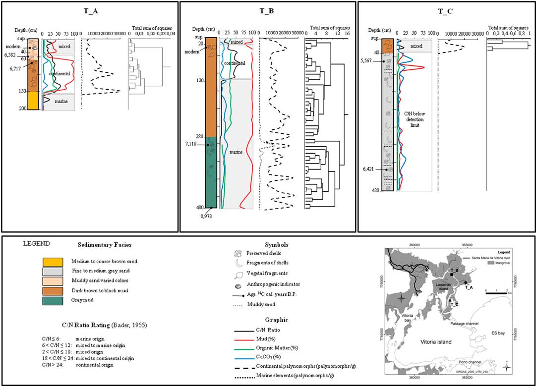
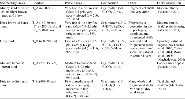
Five sedimentary facies were identified: (1) muddy sand of varied colors (light brown, gray and blue), (2) dark brown to black mud, (3) gray mud, (4) medium to coarse brown sand, and (5) fine to medium gray sand. In Table 1 and Figure 2, the details of each of these facies are explained: the location within the cores, the granulometric size, the composition of the sediment, and other information such as the presence of fragments of shells and vegetation.
Stratigraphic profiles of the T_A, T_B, and T_C cores in the Vitoria estuary: sedimentary facies, sediment composition, dating, concentrations of continental and marine palynomorphs, C/N ratio values and their associated environments according to the limits established by Bader (Reference Bader1955) for the origin of organic matter. The dendograms refer to concentrations of marine elements and continental palynomorphs.

Description of the sedimentary facies.

Description of the Cores
CORE T_A
The organic matter content is negligible (1%) and mud content relatively low (4%) in the sandy facies (from 200 to 150 cm), changing sharply to high values (31% organic matter and 98% mud) in the muddy facies of this core (from 150 to 60 cm). At the top of the core, the levels of organic matter (5%) and mud (30%) are reduced, but significant for mud in the muddy sand facies (Table 1, Figure 2).
The sandy facies at the base of core T_A did not contain any bioclastic fragments in the sediment, but did have C/N values that indicated organic matter of marine origin (C/N between 0 and 3) at 170 cm (Figure 2).
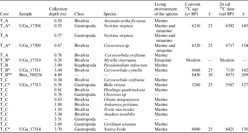
Between 150 and 40 cm core depth, organic matter of continental origin was identified from high C/N values, between 23 and 56, indicating an environment without aquatic vegetation. This range is marked mainly by dark brown to black mud facies and contains marine/estuarine mollusks, fragments of bioclasts and many plant fragments (leaves and roots), reflecting the high organic matter content. The valve from a shell of a Crassostrea sp., common in marine and estuarine environments, located 67 cm from the T_A surface, was dated to 6717±154 cal BP (Figure 2, Table 2).
Taxonomy of the shells found in the cores and conventional radiocarbon ages (14C), calibrated for before 1950 (cal BP) using a mean age of 5568 yr.

* Dated shells.
** Dated organic sediment.
A change in the sediment is observed between 60 and 40 cm, where coarser sediment was recorded; a gradual reduction of the C/N ratio was measured, which starts to assume value indicating a mixed source tending towards continental at exactly 40 cm (C/N equal to 23). A well-preserved gastropod of the species Neritina virginea, common in a marine/estuarine environment, was found at 55 cm depth with an age of 6582±145 cal BP (Figure 2, Table 2).
Between 35 and 0 cm, the C/N ratio gradually decreases and assumes values of a typical transition environment (C/N between 13 and 18), again indicating the entry of organic matter of marine origin into the system, noting an exception of a C/N of 29 at 10 cm depth. The top of this core corresponds to the modern estuary. This layer is characterized by muddy sand facies with finer sands, higher mud content and poorer selection than the previous interval, illustrating a change in sedimentation pattern resulting from a quieter environment. At 25 cm depth, a plastic bottle cap was found, signaling anthropogenic influence and the recent age of the deposit (Figure 2).
The preservation of palynomorphs was not observed at the base of the T_A core. Continental palynomorphs appears suddenly at 150 cm depth (30,279.2 palynomorphs/g), then decrease between 140 and 120 cm depth (10,779.9–7560.5 palynomorphs/g). From 120 to 110 cm depth, palynomorphs increased (13,765.0–24,582.0 palynomorphs/g), then again decreased toward the top of the sample. The marine elements (foraminiferal linings) showed a tendency to increase in concentration from 150 cm (297.8–311.8 palynomorphs/g) to 100 cm depth, at which their highest value for this core was observed (1011.3 palynomorphs/g). Above 100 cm depth, a downward trend extending to the top of the core (671.4–287.1 palynomorphs/g) is observed (Figure 2).
CORE T_B
Organic matter (27%) and mud (95%) contents are high throughout the entire core (Table 1, Figure 2). Between 480 and 120 cm depth, the C/N ratio was between 0 and 8. Between 110 cm and 0 cm, the C/N ratio increased sharply to range between 21 and 63, with the exception of the 10 cm sample with a C/N of 14 (Figure 2).
The interval between 480 and 280 cm depth is characterized by the presence of marine shells such as Paradentalium infractum and Caryocorbula cymella. These samples have varying CaCO3 and organic matter contents that indicate an environment under marine influence, confirmed by a C/N ratio between 0 and 8. The organic sediment at the base of this core (480 cm depth) was dated at 8973±209 cal BP. A well preserved valve of a bivalve species common in the marine environment, Caryocorbula cymella, was found at approximately 3 m depth; dating indicated an age of about 7110±142 cal BP for this specimen (Figure 2, Table 2).
The sediment between 280 and 0 cm depth is characterized by high organic matter content (30%) and the presence of marine/estuarine and estuarine shells, as well as vegetal fragments near the surface. The C/N ratio values indicate an organic contribution of marine origin from the beginning of the deposition of this muddy facies until the 120 cm layer was deposited. Above this depth, the C/N ratios (between 26 and 63) indicate a change to a continental environment until 15 cm, which subsequently evolves into a transition/mixed environment tending toward continental between 10 and 0 cm (C/N between 14 and 21; Figure 2).
An estuarine shell with two closed valves of the bivalve species Mytella charruana, collected at 25 cm depth, dated the deposit to the modern age (Table 2). The base of the T_B core (480 cm depth) had a low total concentration of continental palynomorphs (2608.2 palynomorphs/g). After this low concentration stage, an increase that then remained relatively stable with small oscillations was observed between 480 and 220 cm depth (4379.8–23,147.4 palynomorphs/g). Subsequently, there was a downward trend in the total concentration from 210 to 50 cm depth (16,838.8 to 9249.0 palynomorphs/g). A slight increase was observed between 40 and 30 cm depth (10,702.0 to 21,057.9 palynomorphs/g) with subsequent decrease in concentration until the top of the core. The marine elements occur in low concentrations from 470 cm depth (168.1 palynomorphs/g) to the surface (96.5 palynomorphs/g) with a single high concentration observed only at 300 cm depth (11,945.8 palynomorphs/g). After the high concentration of marine elements the values tend to decline to the surface and are similar to those observed at the base of the core (Figure 2).
CORE T_C
The organic matter contents are negligible (1%); the mud contents in the sandy facies (430 to 40 cm) are relatively low (3 to 78%, averaging 10%), with higher values in the muddy sand lenses. At the top, organic matter content (4 to 20%, averaging 11%) and mud (11 to 30%) are more significant than at the base of the core (Table 1, Figure 2).
Although the C/N ratio between 430 and 40 cm depth fell below the limit of detection due to the absence of organic sediment, the presence of many fragmented and whole marine shells indicates environmental conditions with greater marine influence (Figure 2). The values of the C/N ratio between 30 m and the top of the T_C sample ranged between 11 and 19, indicative of transition environments in the presence of organic matter (Figure 2).
Two marine gastropods were dated in this sandy facies. A Natica livida located 3.7 m below the surface was dated to approximately 6421±138 cal BP. The Bulla striata, located at 58 cm depth, was dated to 5567±127 cal BP (Table 2). Due to the large number of mollusks present at this depth, this date seems to relate to an important event.
From the base of the core up to 40 cm depth, it was not possible to recover continental and marine palynomorphs. Between 30 and 20 cm depth, there is an increase in the concentration of palynomorphs (14,919.7–19,395.0). A slight decrease in the total concentration (6124.6 palynomorphs/g) at 10 cm depth and a small increase at the top of the core (9484.9 palynomorphs/g) were then observed. The marine elements had a higher concentration at 30 cm depth (247.0 palynomorphs/g), then decreased to a new stable level towards the top of the core (189.5–187.8 palynomorphs/g; Figure 2).
DISCUSSION
Transgressive Phase
The organic sediment located 4.8 m below current sea level, dated to 8973±209 cal BP, was obtained from the base of the gray mud facies located on Lameirão Island (T_B). Geochemical indicators (C/N ratio <8) and the presence of fragmented and preserved marine shells indicate the marine influence in this facies. Caryocorbula cymella, for example, was collected 3 m below current sea level and dated to 7110±142 cal BP. This species of bivalve is characteristic of euryhaline environments (Rios Reference Rios2009); its occurrence was also observed in an estuarine-lagoon environment in the Southeast of Brazil (Martínez et al. Reference Martínez, Mahiques and Burone2013). Concentrations of marine elements (foraminiferal linings) in this facies were low (168.1 palynomorphs/g) at the base of the core. At 3 m depth, however, a sudden increase to the highest palynoforaminiferous concentration was observed in the T_B core (11,945.8 palynomorphs/g), occurring around 7000 cal BP. In this same range, a high concentration of shells was observed. Stancliffe (1990) observed that palynoforaminifera are always related to conditions of greater salinity in the environment.
Facies with similar characteristics were recognized as a transgressive deposit in the Doce river plain (~100 km north of the study area), with an age of ~8000 cal BP (Rossetti et al. Reference Rossetti, Polizel, Cohen and Pessenda2015), an environment also interpreted by Cohen et al. (Reference Cohen, França, Rossetti, Pessenda, Giannini, Lorente, Buso, Castro and Macario2014) as typical of a central estuary/lagoon-bay basin.
For many areas of the Brazilian coast (Martin and Suguio Reference Martin and Suguio1992; Angulo et al. Reference Angulo, Lessa and Souza2006) and elsewhere along the South American coast (Milne et al. Reference Milne, Long and Bassett2005), sea level was higher 7000 years ago (Suguio et al. Reference Suguio, Martin, Bittencourt, Dominguez, Flexor and Azevedo1985). However, according to Rossetti et al. (Reference Rossetti, Polizel, Cohen and Pessenda2015), transgressive deposits dating from 8161–7933 cal BP and 4974–4850 cal BP appear to show a sea level above the current level on the north coast of ES state between the Early and Middle Holocene. According to Buso et al. (Reference Buso, Pessenda, de Oliveira, Giannini, Cohen, Volkmer-Ribeiro, Oliveira, Favaro, Rossetti and Lorente2013b), pollen and isotope data suggest the existence of a humid climate from ~17,000 cal BP onward, with increasing humidity between ~7000 and 4000 cal BP on the northern coast of ES. The region of Vitoria also seems to have experienced a tropical humid climate since the Early Holocene.
Between 7521–4847 cal BP, the northern coast of ES experienced a transgressive phase, according to palynoforaminifera and dinoflagellate cysts found in a lake located 23 km from the ocean (Lorente et al. Reference Lorente, Pessenda, Obooh-Ikuenobe, Buso, Cohen, Meyer, Giannini, Oliveira, Rosseti, Borotti Filho, França, Castro, Bendassoli and Macario2014). This same pattern of marine transgression from 7550 cal BP was observed by França et al. (Reference França, Alves, Castro, Cohen, Rossetti, Pessenda, Lorente, Fontes, Buso, Giannini and Francisquini2015) by means of δ13C and δ15N analysis on sediments collected from the Doce river delta plain.
Sediments with similar characteristics and age (7200 cal BP) to those found at the base of the T_B core were also found by Bastos et al. (Reference Bastos, Vilela, Quaresma and Almeida2010) at the base of another shallow core sample. That core was collected at the bottom of the widest part of the main channel in Vitoria Bay, approximately 3 km south of the RSMV mouth. This and other cores were interpreted, using assemblages of foraminifera, mollusk dating and seismic data, as composed of a transgressive muddy facies indicating an open bay with a strong connection to the sea.
Freitas et al. (Reference Freitas, Barreto, Barth, Bastos and Baptista Neto2016), analyzing two cores collected in the estuary of the Piraqué-açu river about 40 km north of Vitoria, observed a pattern of differentiation in the total concentration of palynomorphs between the cores. According to Hoffman (2002), site-specific features such as circulation, wind direction and sedimentation rate may influence the deposition, accumulation and preservation of palynomorphs within a single estuary. Similarly, Cohen et al. (Reference Cohen, França, Rossetti, Pessenda, Giannini, Lorente, Buso, Castro and Macario2014) observed that during the Holocene, the vegetation around the Doce river delta plain found favorable conditions for the establishment of palynomorphs, balancing the influence of the relative sea level variation and sediment transport by river. This may explain the preservation of high concentrations of continental palynomorphs in the closest cores to the mouth of the Santa Maria da Vitoria river (T_B), even with sea level rise. According to Mourelle et al. (Reference Mourelle, Prieto, Pérez, García-Rodríguez and Borel2015), local differentiation related to climate or geomorphology might establish different records of fossil pollen at different times during the Late Holocene.
In general, marine transgressions in estuary are indicated by presence of marine fauna, while upper-marsh pollen decreased (Trog et al Reference Trog, Höfer, Frenzel, Camacho, Schneider and Mäusbacher2013). Such observations were also made by Bartholomeu et al. (Reference Bartholomeu, Barros, Lopes, Barth and Vilela2014) and Barreto et al. (Reference Barreto, Baptista Neto, Vilela and Barth2015) using the palynological analysis of peat sediments in Guanabara Bay, southeast Brazil. However, this relationship seems not to have been straightforward in the Vitoria estuary. Continental palynomorph concentrations were relatively high, despite the slight downward trend during transgression.
Bastos et al. (Reference Bastos, Vilela, Quaresma and Almeida2010) reported that during the Holocene transgression, the marine domain seems to have prevailed in the bay of Vitoria. Thus, our interpretation here is that around 8973±209 cal BP, the environmental conditions of an open bay existed in the region of Vitoria. Around 7110±142 cal BP, the estuary experienced a significant increase in salinity, suggesting that it was the time when sea level surpassed the current sea level in the Holocene. These data seem to correspond to the curve proposed by Angulo et al. (Reference Angulo, Lessa and Souza2006), which suggests that sea level would have exceeded the current level along the southeast coast around 6600 cal BP. The difference between these ages can be attributed to inherent limitations in the calibration methods as well as a local tectonic factor such as subsidence.
High Sea Level Phase
Even under marine influence, the data from the island of Lameirão suggest an environment with restricted connection to the sea in inner areas of the bay. The lithologic and compositional homogeneity of dark brown and black muddy facies, the presence of marine/estuarine and estuarine shells, the presence of plant fragments and the high levels of organic matter present in the T_B and T_C cores indicate that it is a tidal plain deposit.
The high values of C/N found in the cores in the Vitoria estuary are in agreement with values in studies of mangrove environments. Bouillon et al. (Reference Bouillon, Dahdouth-Guebas, Rao, Koedam and Dehairs2003) found high C/N values between 17 and 25 in mangrove sediments rich in organic matter in estuaries in Sri Lanka. Previous research by Bouillon et al. (Reference Bouillon, Raman, Dauby and Dehairs2002) notes that higher C/N values in sediments suggest greater contributions from terrestrial sources, with values ranging from 7 to 27.3 as in mangrove sediments. Grillo et al. (Reference Grilo, Neto, Vicente, Castro, Figueira and Carreira2013) and Costa et al. (Reference Costa, Grilo, Wolff, Thompson, Figueira and Neto2014) found a C/N ratio in the present estuary in the Passage Channel, in Vitoria Bay, of between 13 and 36; this indicates a predominance of terrestrial source carbon associated with the entrance of sewage. Thus, mangrove reservoirs, despite being conceptually mixed/transition environments, may have a C/N ratio beyond values that are theoretically intermediate, reflecting periodic shifts between greater marine or continental influence.
The C/N ratio indicated that the estuary begins to be established even in the presence of organic material of marine origin (C/N <8), between 280 and 120 cm depth in the T_B core. Because it is an area closer to the mouth of the river, it is understandable that it maintains high concentrations of continental palynomorphs from the bottom to the top of this core, regardless of any change in C/N ratio values.
The abrupt change from sea to continental C/N in the T_A and T_B cores occurred at similar depths, 150 cm and 110 cm respectively. This change suggests the sudden entry of organic matter from higher plants with C/N values between 26 and 63, signaling an increase in terrestrial carbon input. According to França et al (Reference França, Alves, Castro, Cohen, Rossetti, Pessenda, Lorente, Fontes, Buso, Giannini and Francisquini2015), the sediments collected in the paleo estuary in the Doce river delta, which contained only organic materials from freshwater and C3 terrestrial plants, had geochemical parameters compatible with other studies (C/N=10–45). This geochemical indicator corroborates the sudden preservation of continental palynomorphs at high concentrations (30,279.2 palynomorphs/g), recorded at 150 cm depth in the T_A core. At this depth, the environment changes, noted due to changes in lithology with the presence of organic matter and low concentrations of marine elements (297.8–311.8 palynomorphs/g). However, the association between the C/N ratio and continental palynomorphs observed in the T_A core was not noticed in T_B, which maintained consistently high concentrations of palynomorphs indicative of a continental source.
The marine/estuarine species Crassostrea sp. and Neritina virginea (6717±154 and 6582±145 cal BP, respectively) had consistent ages, and were situated approximately 0.5–0.8 m below current sea level in facies interpreted as tidal plain deposits. According to Angulo and Souza (Reference Angulo and Souza2014), estuarine and lagoon facies are generated in the intertidal zone, such as tide plains and tidal outflow channels. However, these facies are found within a restrictive range of depths, limited by the amplitude of the tide and by the indicator used. Considering that the dated shells were found in muddy sediment typical of a tidal plain, it is accepted that the position of the preserved shells found in this type of deposit would be close to the paleo marine level at that time. Our data therefore suggest that around 6700–6600 cal BP, this historical sea level might be similar to current sea level. However, we note that caution must be used when using such shells as indicators, because they can be older than the deposits due to reworking during transport.
The influence of coastal geomorphology in the area of study, dominated by rocky outcrops and shores, allows us to interpret that with the Holocene transgression, the region of Vitoria was more submerged than in present day, favoring the configuration of a bay with several channels of communication with open sea. Moderately to poorly selected river sand remnants of an earlier regressive period are drowned; some of these deposits are locally reworked by tides (Machado et al. Reference Machado, Albino, Leal and Bastos2016). An example of this is the T_A core; it is from a more sheltered area with little connection to coastal sands, yet a sandy facies is present at the base. The medium to coarse diameter of grains seem to reflect a geological heritage. The moderately good selection suggests discharge via associated transport conditions. Another example is the sandy facies found in the T_C core, located in the relatively more dynamic part of the estuary, in the vicinity of the present Passage Channel. The variable concentrations of bioclasts in the T_C core, including beds of disarticulated marine shells, and the absence of organic matter ensure high hydrodynamics forcing deposited this facies, which points to a deposit strongly influenced by marine waters inside the estuary (Machado Reference Machado2014).
According to Angulo and Souza (Reference Angulo and Souza2014), the deposit of disjointed shells is a sign of reworking by waves and currents and may occur above, near (inter-tidal zone) or below sea level. The third case may be associated to environments corresponding to shallow bottoms (Angulo et al. Reference Angulo, Pessenda and Souza2002). In this case, the aforementioned sandy facies appear to be a remnant of a river deposit, little reworked by the tidal currents, forming a tidal channel bottom (Machado Reference Machado2014). As the depth of burial of shells and fragments and transport distance is unknown, it is not possible to identify sea level at that time. The bank of shells is an indicator that allows the inference only that the paleo sea level was greater than a certain value.
Ages obtained for the paleo tidal channel, comprising a nearly 4 m thick reservoir, were dated close to the base at 6421±138 cal BP (–3.7 m from sea level) and near the top at 5625±127 cal BP (–0.6 m from sea level). These shells are marine species (Natica livida and Bulla striata as well as all others identified in the T_C core). This suggests that for almost a thousand years, the paleo channel remained at the entrance to the estuary near the Passage Channel and accompanied the rise of sea level, while the water depth at the channel bottom is still unknown.
According to Angulo et al. (Reference Angulo, Lessa and Souza2006), sea level rise would have occurred up to 5000–5800 cal BP, when it reached the maximum. In the ES scenario, Ribeiro (Reference Ribeiro2011) finds from the leveling and dating of vermetid encrustations in Guarapari, on the south-central coast of the state, a Holocene maximum occurring around 5700 cal BP, reaching approximately 4 m above current sea level. Even without a record of the Holocene maximum in the region of Vitoria, the date of 5567±127 cal BP (from the bed of shells at 0.6 m below current sea level) in the T_C core still marks a period of strong marine influence. It seems to illustrate a time close to the transgressive maximum with a probable paleo sea level of 3.4 m above the current, discounting the paleo maximum level of 4 m above proposed by Ribeiro (Reference Ribeiro2011) for this period in the southeast coast of ES.
Regressive Phase
The onset of mangrove sedimentation seems to indicate the beginning of marine regression in the internal cores, identified primarily by the abrupt change from marine to continental C/N. However, the lateral variations of sedimentary deposits in the bay of Vitoria are controlled by the presence of islands and promontories, which in turn create distinct hydrodynamic conditions within the estuary. This seems to define the predominance of the organic contribution type (continental or marine) and capacity of preservation of palynomorphs in the estuary, locally creating distinct environments at the same marine paleo level. This may explain the in-depth similarity of the abrupt change in the C/N values from marine to continental found in the more sheltered areas (T_A and T_B), whereas in a more exposed area (T_C) this was not observed. The maintenance of high concentrations of continental palynomorphs in the innermost cores can be explained by the entrapment of the pollen grains in this sheltered and low energy environment, therefore not necessarily indicative of a relative drop in sea level.
The identification of a mixed environment, indicated by the sedimentological, geochemical, micropaleontological, malacological and chronological data at the top of the three analyzed cores, indicates regressive sedimentation that remains up to the present day in the form of tidal plain deposits.
The stratigraphic sequence found in the T_C core suggests that the environment evolved from a condition with strong marine influence, occurring around 6421±138 and 5567±127 cal BP, to a transition environment at the top. That transition was identified from the following indicators: intermediate C/N ratio values between 11 and 19, high concentrations of continental palynomorphs (between 6124.6 and 19,395.0 palynomorphs/g), decreasing concentrations of marine elements (<247.0 palynomorphs/g), and the presence of a bivalve with two closed valves dated to the modern age.
The trend of reduction in the concentration of marine elements from 30 cm depth (247.0 palynomorphs/g) to the top (187.8 palynomorphs/g) in the T_C core indicates the influence of marine waters in this area, but suggests a reduction in the salinity of water. The high concentrations of continental palynomorphs from 30 cm (14,919.7 palynomorphs/g) to 20 cm (19,395.0 palynomorphs/g) may indicate that with the reduction of marine influence, the contiguous palynomorphs gradually found a more favorable depositional environment.
The analyzed records suggest continuous maintenance of an estuarine system to the present. This could be explained by a low sedimentation contribution, corroborated by Bastos et al. (Reference Bastos, Vilela, Quaresma and Almeida2010) and Veronez et al. (Reference Veronez, Bastos, Pizzin, Gava, Quaresma and Silva2009a) in the bay of Vitoria. Some subsidence, even at very low rates and not yet identified in the region, would allow the preservation of the tidal plain.
CONCLUSION
Multiproxy analysis using the C/N ratio, palynomorphs, grain size, shell species, and 14C dating led to a paleoenvironmental interpretation of the Vitoria estuary and its response to sea level changes during the Holocene. The results point to a transgressive phase in the early Holocene, followed by a high sea level and a subsequent marine regression in the Vitoria estuary.
Elemental analysis from the cores suggest environmental conditions of an open bay beginning at 8973±209 cal BP with a marine environment, followed by a sudden entry of organic matter of terrestrial origin into the more sheltered regions. The abrupt change from marine to continental C/N seems to indicate the moment of sea level retreat and the start of the regression phase. Near the surface, the C/N ratio values indicate a mixed carbon source environment in all three cores.
Around 7110±142 cal BP, the estuary seems to have experienced a strong entrance of marine water, likely to coincide with an increase in sea level. Around 6700–6600 cal BP, the sea level was still very close to the current one. Even without a record of the Holocene maximum, the dating of 5567±127 cal BP still marks a situation of strong marine influence and seems to represent a period close to the transgressive maximum, followed by a sudden change in sedimentation dated to the modern age.
Even under marine influence, there is a more restricted environment in more internal areas of the estuary in the bay of Vitoria and near Lameirão Island; that environment is typical of mangrove areas, shown through deposits indicative of a tidal plain. In the most exposed areas, such as in the Passage Channel, drowned river sands composed of many marine mollusks signal higher energy local conditions, such as a tidal channel bottom deposit. The maintenance of an estuarine system to date, even with the Holocene regression, is identifiable from geochemical, micropalentological, malacological and chronological indicators and by the current tidal plain deposits at the top of the stratigraphic sequences.
Local constrains such as the complexity of the sedimentary inheritance, the geomorphological control and the lateral variations of the deposits due to the oscillations of the relative level of the sea, can create locally distinct subenvironments for the same paleo marine level. For the study area, an important role played in deposit formation is therefore attributed to the low hydrodynamic and fluvial courses, even small ones, in sedimentation and the palynomorphic preservation capacity within the estuary.
The Holocene ages obtained allowed us to interpret sea level variations which are compatible with previous Brazilian research studies.
ACKNOWLEDGMENTS
The authors would like to thank the Foundation for the Support of Research in Espírito Santo (FAPES-Universal 2014) for the financial support and scholarship of the first author and the Coordination for the Improvement of Higher Education Personnel (CAPES) for providing a sandwich scholarship at the University of Wollongong, Australia. The authors are also grateful to the Department of Geology (LAGEMAR) of UFF for the geochemical analysis, to the Laboratory of Malacology of UFES for the classification of the shells and to the undergraduate scholarship students in Environmental Oceanography of UFES for help in the field and sedimentological analysis.