Trinidad has traditionally been considered the initial stepping stone for movements of diasporic Archaic and Ceramic Age peoples and subsequent interaction in at least the Lesser Antilles (Boomert Reference Boomert, Keegan, Hofman and Ramos2013; Granberry Reference Granberry, Keegan, Hofman and Ramos2013; Heckenberger Reference Heckenberger, Keegan, Hofman and Ramos2013; Rouse Reference Rouse1986, Reference Rouse1992; but see Hanna Reference Hanna2019). Located less than 20 km apart, Venezuela can be seen from a few vantage points in Trinidad on clear days. Although considered part of the West Indies, the island of Trinidad is continental in character. Lying on a shallow continental shelf, it shares a geology and a diverse biota with eastern Venezuela and Guyana (Boomert Reference Boomert, Keegan, Hofman and Ramos2013:141; Farrell et al. Reference Farrell, Duncan, Jones, Dunning, Pearsall and Siegel2018:77; Newsom and Wing Reference Newsom and Wing2004:58). It is noteworthy that Trinidad was connected to the South American mainland throughout the late Pleistocene. Nautical charts reveal that the semi-enclosed Gulf of Paria to the west of Trinidad is a relatively shallow inlet with an average depth of 20 m. At that level and below, a land bridge(s) existed between Trinidad and the mainland. However, a 2+ m rise in sea level (due to rapidly melting ice packs) during the early part of the Holocene inundated the land bridge(s).
Evidence for a presumed Paleoamerican occupation in the West Indies has been limited previously to a single contracting-stemmed chipped-stone spearpoint found in eastern Trinidad known as the “Biche point” (Harris Reference Harris, Cummins and King1991:73–74; Figure 1). The Biche point has generally been regarded as the earliest artifact in Trinidad. Harris (Reference Harris, Cummins and King1991) referred to the Biche point as “a Paleo-Indian stemmed point,” and Boomert (Reference Boomert2000:49) noted that it “forms the only indication yet available that Lithic-age hunters-foragers, affiliated with the Joboid series, occupied Trinidad during late Pleistocene to early Holocene times.” More specifically, Boomert (Reference Boomert2000:49) suggested that the Biche point belongs to the Canaiman subseries of the Joboid series. Hofman et alia (Reference Hofman, Rodríguez Ramos, Pagán Jiménez and Reid2018:71) also referred to the Biche point as “Joboid” and asserted that “humans were active on this island [Trinidad] (then still part of the mainland) . . . , i.e., around 10000 cal BP.”
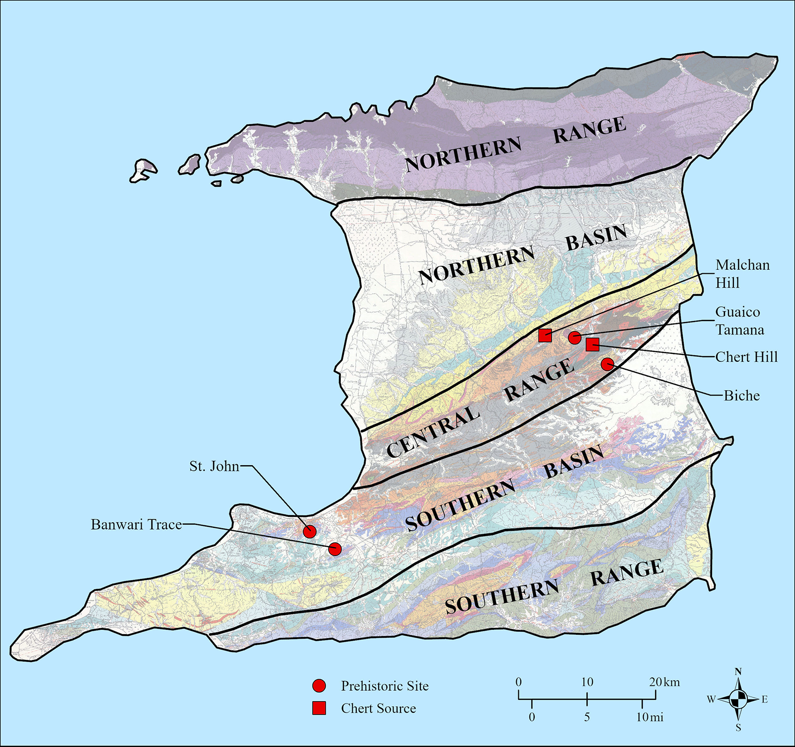
Location of the Guaico Tamana and Biche sites, two nearby chert sources in the Central Range, and other early sites in Trinidad. (Color online)

Figure 1 Long description
Long description: Map of Trinidad highlighting prehistoric sites and chert sources. The map is divided into distinct geographic regions: Northern Range, Northern Basin, Central Range, Southern Basin and Southern Range. Prehistoric sites are marked with red dots, while chert sources are indicated with red squares. Key locations include Malchan Hill, Guaico Tamana, Chert Hill, Biche, St. John and Banwari Trace. The map includes a scale bar indicating distances in kilometers and miles and a compass rose for orientation.
Reference to the Biche point as Joboid gives deference to late Pleistocene-age points found first in the vicinity of El Jobo in northern Venezuela (Cruxent Reference Cruxent1956) and later documented at other nearby sites such as Taima-Taima and Muaco (e.g., Bryan et al. Reference Bryan, Casamiquela, Cruxent, Gruhn and Ochsenius1978; Cruxent Reference Cruxent1961, Reference Cruxent1967; Jaimes Reference Jaimes1998; Ochsenius and Gruhn Reference Ochsenius and Gruhn1979). At the spring-fed water hole of Taima-Taima, radiocarbon samples of organic materials believed to be associated with El Jobo projectile points dated between ca. 14,800 and 12,800 BP (18,170–15,270 cal BP). The site is controversial, but most archaeologists accept these dates to represent a general time frame for the El Jobo projectile point type (see Adovasio Reference Adovasio2002: 203–204).
Ray (Reference Ray2015) argued that the Biche specimen is most similar to projectile points of the Paijan complex centered in northern Peru (Chauchat Reference Chauchat1975; Maggard Reference Maggard2010). More specifically, Ray (Reference Ray2015:16) suggested that the Biche point “appears to be a Contracting Narrow Stem variety of Paijan points, which have a maximum age range of ca. 9500–8500 BP (10,750–9510 cal BP) in northern Peru” (see Maggard Reference Maggard2010:364–377). Ray (Reference Ray2015:16) further argued that “this places the Biche specimen in the . . . Early Archaic period of the Early Holocene” and is older than the deposits at Banwari Trace, long thought to be the earliest site in Trinidad (Boomert Reference Boomert2000:57; Tankersley et al. Reference Tankersley, Dunning, Owen and Sparks2018:681–695).
Professional archaeological investigations have been conducted in Trinidad for more than 80 years (Boomert Reference Boomert2000; Boomert and Harris Reference Boomert and O’Brien Harris1988), but most of these were geographically biased and focused on large shell midden sites in coastal and estuarine areas. Inland areas, and especially rugged highland areas of the Northern and Central ranges, were largely uninvestigated. Until recently, very few precontact sites had been previously recorded in the Central Range, and no confirmed habitation sites had been documented in interior portions of the Northern Range. However, recent investigations suggest a potentially substantial presence of precontact people in at least the central portion of the Northern Range (Lopinot and Ray Reference Lopinot and Ray2018:59–63), and we suspect the same is true for the eastern portion of the Central Range (Ray Reference Ray2015:10–11).
In this article, we present the results of archaeological investigations at a recently discovered site in the Central Range named Guaico Tamana (SAN-11). This site yielded only the second chipped-stone spearpoint that has been documented in Trinidad. The site has also produced the oldest radiocarbon age from archaeological contexts in Trinidad, preceding the oldest age obtained from Banwari Trace (SPA-28) by a millennium. The existence of a radiocarbon-dated archaeological site characterized by the presence of a contracting-stemmed projectile point similar to the specimen found at Biche and other associated chipped-stone debris provides new insights into the colonization of Trinidad and the West Indies in general, with implications for future research on that island and beyond.
The Biche Point and Site Condition
Before discussing the Guaico Tamana site and its associated material culture, we present a brief overview of the Biche site and the spearpoint found there. The first chipped-stone spearpoint (referred to as the Biche point) found in Trinidad was discovered by Jameel Baksh in 1988 (Harris Reference Harris, Cummins and King1991). The spearpoint was found in the small village of Biche in the eastern portion of the Central Range (Figure 1). Peter Harris and Arie Boomert visited the Biche site (NAR-9) shortly after its discovery. They noted the point was found in a shallow erosional channel near Baksh’s house and that the surrounding area was “littered with blocky pieces of poor-quality brown sandstone (4–13 cm) eroding from the surface, together with a few mudstone pebbles (1–5 cm)” (Harris Reference Harris, Cummins and King1991:73). No additional chipped-stone artifacts were found in the vicinity, technically relegating the Biche point to an isolated find.
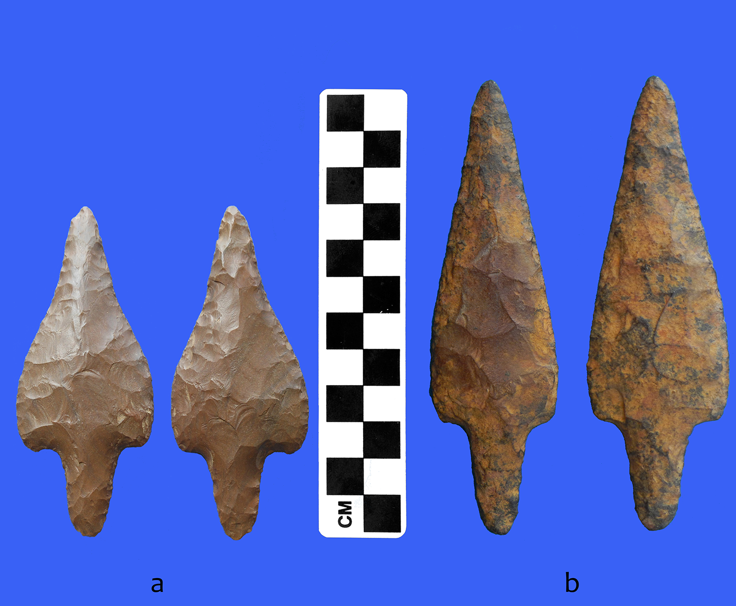
The chert spearpoint found at Biche is complete (Figure 2a) with a length of 92.4 mm and a maximum thickness of 13.5 mm (Ray Reference Ray2015:15). The blade and stem were thinned by soft-hammer percussion and finished by pressure flaking. The blade has a maximum width of 37.9 mm near the shoulders, which are prominent and slightly rounded. The blade is broad at the proximal end but recurves to a narrow distal end. The stem, which is 24.6 mm long, is relatively narrow and contracts to a pointed base. The chert is dark yellowish brown (10YR 4/4) and highly patinated, which makes raw material identification difficult. Although Chert Hill chert cannot be ruled out, physical properties such as texture, hardness, and luster suggest that it was probably made from high-quality Malchan Hill chert (Ray Reference Ray2015:7–10) found 6 km to the west (Figure 1).
Obverse and reverse sides of contracting-stemmed spearpoints found at the Biche (a) and Guaico Tamana (b) sites. (Color online)

Figure 2 Long description
Long description: The figure shows the obverse and reverse sides of two stone spearpoints arranged against a solid blue background, with a black and white checkered scale bar marked CM standing vertically in the centre for size reference. The point on the left is from the Biche site and is smaller. It has a narrow contracting stem and a pointed tip. The point on the right is from the Guaico Tamana site. It is larger and has broad knapping scars across its surface. Both spearpoints are elongated and roughly leaf shaped, tapering to a point at the top with narrowing stems.
The discovery of a second chipped-stone spearpoint at the Guaico Tamana site resulted in renewed interest by the authors to relocate the Biche point find spot and reevaluate its potential for yielding additional artifacts and stratigraphic information. The original finder of the Biche point, Jameel Baksh (now Jameel Mohammed), was contacted and a meeting arranged to discuss the specific find-spot location. We conducted limited test excavations on the property, and our findings confirmed earlier observations made by Harris and Boomert that none of the original deposits at the Biche site remain intact.
Investigations at Guaico Tamana
The Guaico Tamana site is located in St. Andrew County in the eastern portion of the Central Range, only 5.5 km to the northwest of the Biche site (Figure 1). It is situated on a ridge near the end of Chunisingh Trace approximately 1.6 km south of the small community of Guaico Tamana. The Cunapo River forms a large meander around the site, with the closest part of the stream approximately 270 m to the southeast. The ridge on which the site is situated forms a local divide that sheds water to three small tributaries of the Cunapo River. The site is on a 5-acre estate of Kishore Lal, whose family has farmed for more than 20 years. In November of 2017, a bulldozer was used to make a small pond measuring a few meters in depth; it was excavated around a small perennial spring located about 75 m southeast of the site (Kishore Lal, personal communication 2019). During this time, he also directed the bulldozer operator to remove about 50–70 cm of sediment from an elliptical knoll (measuring approximately 1 m high, 20 m wide, and 50 m long) that spanned the site from west to east. A large contracting-stemmed spearpoint was found by Lal’s workers as sediment from the knoll was being removed by the bulldozer. We heard about the discovery of the spearpoint at Guaico Tamana in 2018 from an acquaintance and friend of Lal’s (Glen Wilkes).
We met with Lal in 2019 for an interview and examined the spearpoint found on his estate. The unbroken projectile point (Figure 2b) is similar in form to the contracting-stemmed specimen from Biche, although it is somewhat larger (125.1 mm long) and slightly thinner. The contracting stem is 30.4 mm long, pointed, and relatively narrow. It is 18.5 mm wide at the blade-stem juncture and 7.4 mm wide 3 mm above the base. The blade is 94.7 mm long and is straight-to-slightly recurved from shoulder to tip. Blade width at the shoulders is 33.4 mm; however, maximum width is 2 mm wider about 10 mm above the shoulders. Maximum thickness at the blade-stem juncture is 10.1 mm. The blade was shaped primarily by secondary (soft-hammer) percussion flaking with the edges finished by pressure flaking. There is no indication of intentional grinding along the base, sides of the stem, or lower portion of the blade. The narrow and pointed contracting stem of this specimen suggests that it was inserted into a socket of a shaft and secured with plant or animal glue, tar pitch, or another adhesive substance. The spearpoint was manufactured from brown (7.5YR 4/4) argillaceous Chert Hill chert (Ray Reference Ray2015:4–7) located 1.5 km to the southeast of Guaico Tamana (Figure 1).
After examining the Guaico Tamana spearpoint, Lal granted a reconnaissance of the site to determine if there were any extant intact cultural deposits associated with the spearpoint. Although large portions of the eastern and western sides of the site had been disturbed, we determined that a narrow 3 m wide area along the east side of an incised north–south access road was partially preserved and contained intact deposits under a relatively thin disturbed cultivation zone. A careful initial inspection and profile of a 1 m wide strip along the east wall of the 45 cm deep road cut revealed 32 in situ chert flakes between 23 and 45 cm below surface (bs). We subsequently focused our investigations within and adjacent to the intact 3 m wide strip (Figure 3).
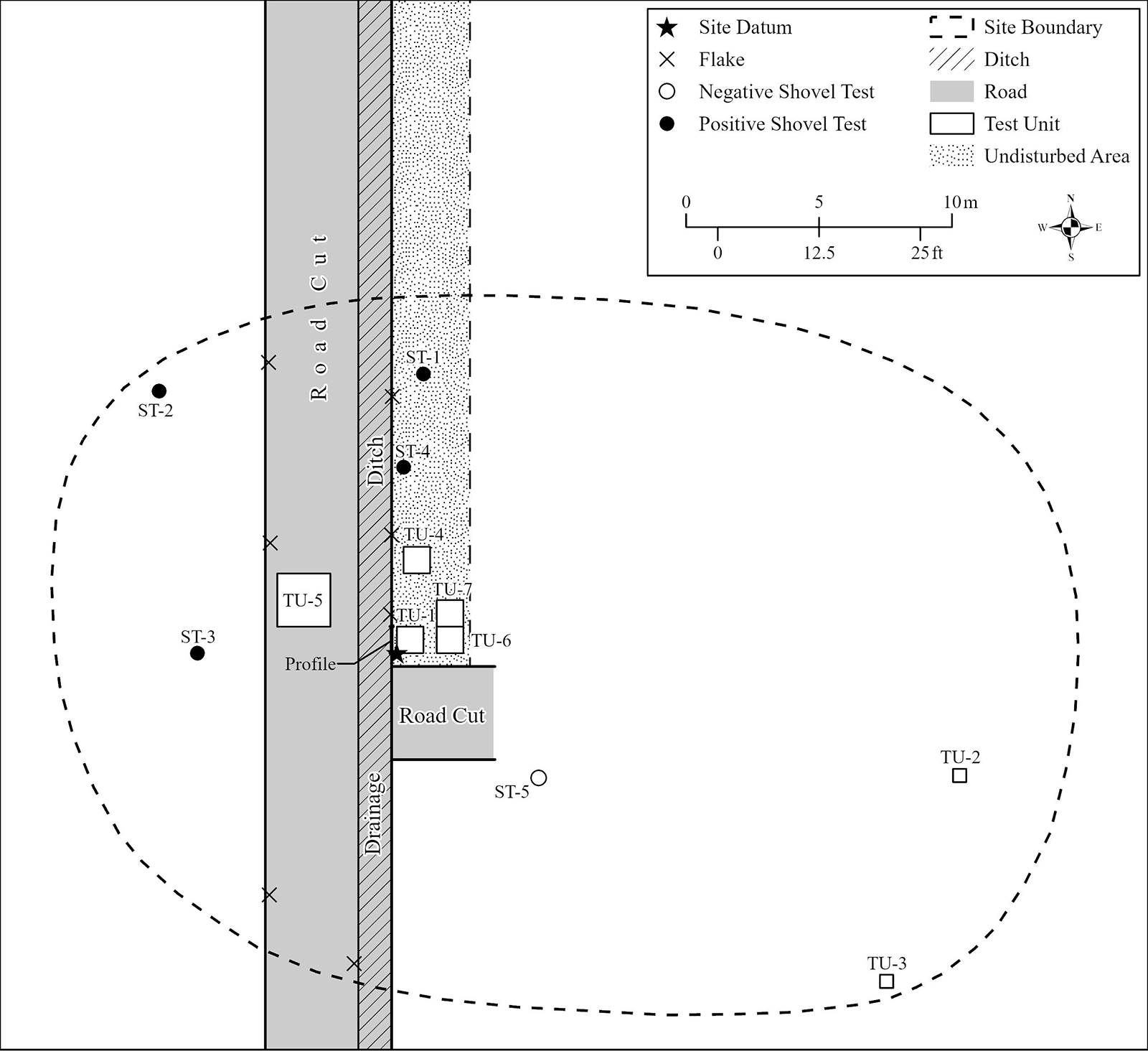
Sketch map of the Guaico Tamana site depicting locations of test units, shovel tests, and approximate site boundaries.

Figure 3 Long description
Long description: The figure is a black and white sketch map of the Guaico Tamana archaeological site. A road runs from top to bottom on the left portion of the map, shown as a shaded strip bordered by a ditch. A large dashed oval outline marks the approximate site boundary, enclosing most of the plotted features. Symbols distributed across the map mark the site datum, flake occurrences along the road cut, negative shovel tests, positive shovel tests, and test unit locations, with labelled points across the area. A legend in the upper right corner identifies each symbol, including site datum, flake location, negative shovel test, positive shovel test, site boundary, ditch, road, test unit, and undisturbed area. A scale bar and a north arrow are also included for orientation.
Site dimensions prior to historic disturbances are indeterminate. However, troweling both walls of the road cut, the excavation of four positive shovel tests, and the general location of the spearpoint revealed that artifacts extended for a distance of at least 25 m north–south x 35 m east–west (Figure 3). Most of the site has been disturbed by farming and construction activities. Farming disturbances include planting root balls of plantain and banana saplings and digging drainage ditches to depths of 40 cm. Localized disturbances include leveling the knoll along the east side of the site and bulldozing a 4.5 m wide access road to a maximum depth of 50 cm across the west side of the site (Figure 3). Lal indicated that the soil is unusual in that it is siltier and typically drier than surrounding terrain that contains more clayey soils.
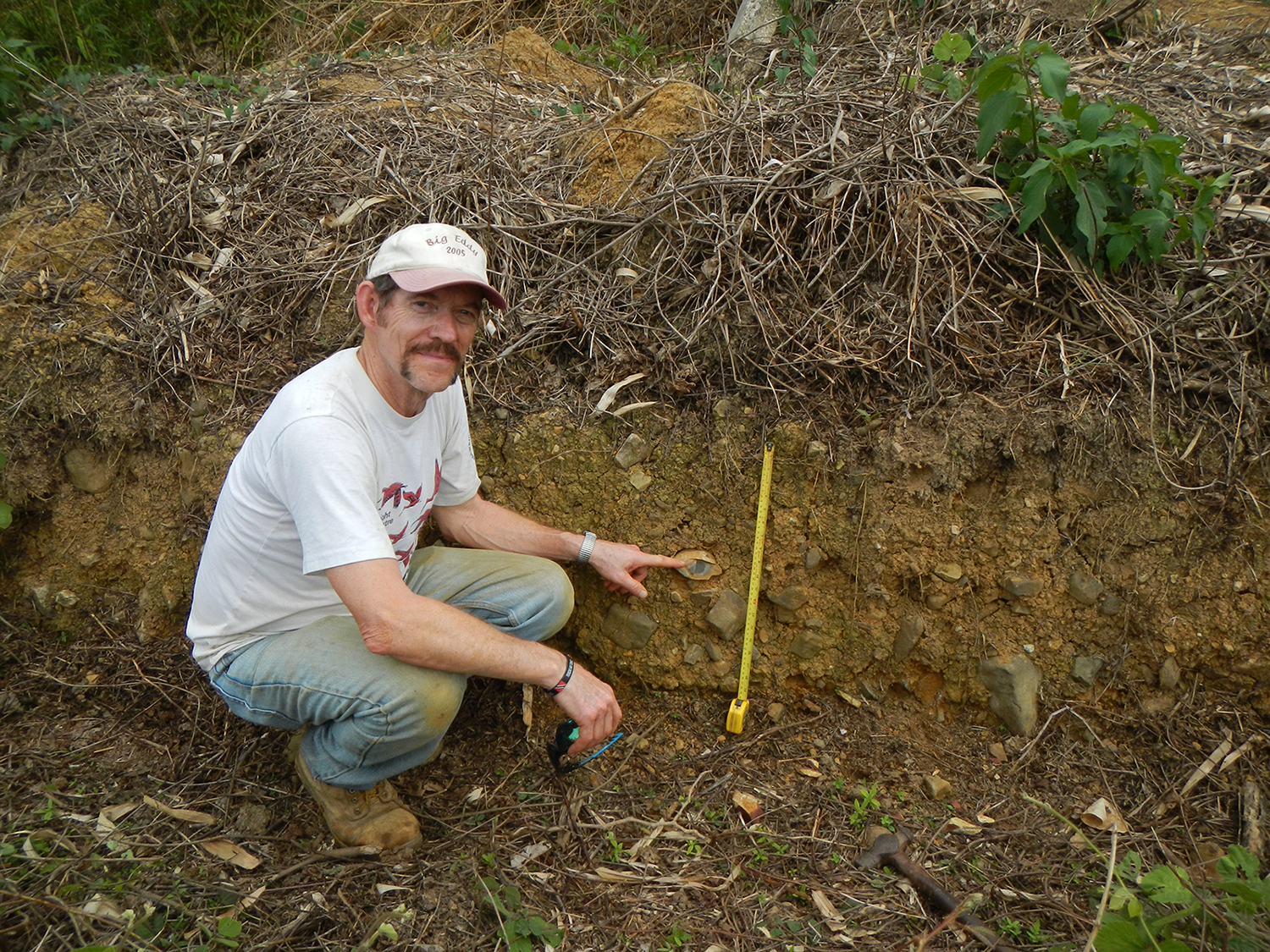
A visual survey of the site and its immediate surroundings in 2019 revealed that the area contains localized deposits of knappable chert. Inspection of a bank exposure of the nearby bulldozed pond revealed a 1 m thick stratum of subangular-to-subrounded redeposited cobbles buried approximately 1.5 m bs. A shallower (10–30 cm thick) cobble layer (that included chert cobbles) was found near the summit of the ridge approximately 75 m southwest of the site (Figure 4). Many of the chert cobbles were small (<7 cm), but four large cobbles measuring between 9 × 9 cm wide and 3.5 cm thick and 18 × 19 cm wide and 16 cm thick were found. The cortex, color, texture, and hardness attributes of the four large cobbles are identical to those sampled at Malchan Hill (Ray Reference Ray2015:7–10). Other smaller argillaceous cobbles found on the ridge exhibited attributes similar to Chert Hill chert. Although not abundant on the surface, it appears that redeposited cobbles of both Malchan Hill chert and Chert Hill chert were incorporated into the upper deposits of the ridge on which the Guaico Tamana site is situated. Large tree-throw divots created by tree toppling probably periodically exposed the shallowly buried stratum of cobbles during early Holocene times. Burning vegetation on the ridge also would have further facilitated the discovery of cobbles that had been brought to the surface by tree throws.
Cobble layer exposed in a drainage cut on the southwest side of the site (view to south). Note dark gray chert cobble pointed to in upper portion of cobble layer (scale: 50 cm). Photo courtesy of Neal Lopinot. (Color online)

Excavation Methods
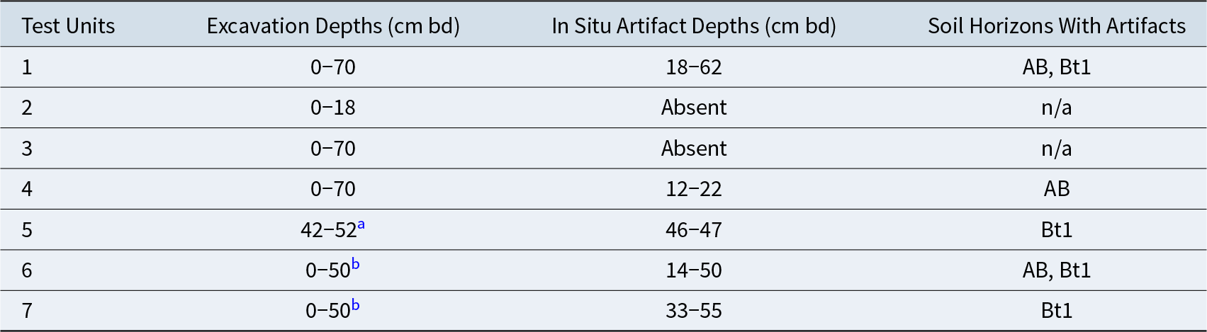
Fieldwork was conducted at Guaico Tamana during 3–5-day periods in March of 2019, 2022, and 2023. Our test investigations consisted of the excavation of two 0.5 × 0.5 m units, four 1 × 1 m units, and one 2 × 2 m unit, comprising a total of 8.5 m2 (Figure 3). Ending depths of the seven test units are presented in Table 1. The two 50 cm2 units (Test Units 2–3) were placed in the vicinity of the former knoll that had been truncated by the bulldozer to determine if any extant cultural deposits were present in that disturbed area. Test Unit 2 was dug where Lal indicated the contracting-stemmed spearpoint was found. Test Units 1, 4, and 6–7 (1 m2) were placed within the 3 m wide strip containing intact deposits (Figure 3). These test units were located on the south flank of the former east–west oriented knoll. Test Unit 1 was placed 20 cm east of the 1 m wide profile on the east side of the access road. Datum was established at the surface of the southwest corner of Test Unit 1. Test Unit 5 (2 m2) was placed within the incised access road (45–50 cm deep) to determine if extant deposits existed below a layer of imported road gravel.
Test Units, In Situ Artifact Depths, and Corresponding Soil Horizons.

Table 1 Long description
Seven test units are listed with excavation depth ranges, where in situ artifacts were found and at what depths, and which soil horizons contained artifacts. In situ artifacts were present in Test Units 1, 4, 5, 6, and 7, and absent in Test Units 2 and 3. Where present, artifact depths range from about 12 to 62 cm below datum, with Test Unit 1 spanning 18 to 62 cm and Test Unit 6 spanning 14 to 50 cm. Test Unit 4 has a narrower artifact depth range from 12 to 22 cm, while Test Unit 5 shows artifacts at 46 to 47 cm within a limited excavated interval. Artifacts are associated with the AB horizon in Test Units 1, 4, and 6, and with the Bt1 horizon in Test Units 1, 5, 6, and 7.
a SW1/4 dug to 70 cm below datum (bd).
b W1/2 dug to 60 cm bd.
All disturbed deposits in each test unit were removed to the top of undisturbed sediment. Test Units 1, 3–4, and 6–7 were subsequently excavated in 10 cm levels to sterile deposits, with all fill screened through ¼-inch hardware cloth. The fill from Test Unit 2 was shoveled and troweled only. After redeposited cobbles were removed from the access road, the undulating surface of Test Unit 5 was shovel skimmed 1–8 cm deep to undisturbed sediment at 52 cm below datum (bd). The southwest quadrant of Test Unit 5 was subsequently excavated and screened to 60 cm bd, and an additional level was shovel skimmed to 70 cm bd. Lastly, five 40 × 40- cm wide shovel tests were dug to depths of 40–90 cm bs along the east and west sides of the access road.
Results of Investigations
The bulk of material that was recovered from test excavations at Guaico Tamana consisted of chipped-stone artifacts. As is typical for any relatively old, shallowly buried, open-air site in the tropics, organic remains (bones, shell, etc.) other than scattered charred plant remains are nonexistent at Guaico Tamana, thus hindering our understanding of animal and plant exploitation. Given the absence of shell, this was undoubtedly a consequence of soil acidity and thousands of years of intensive biological activity and other taphonomic processes.
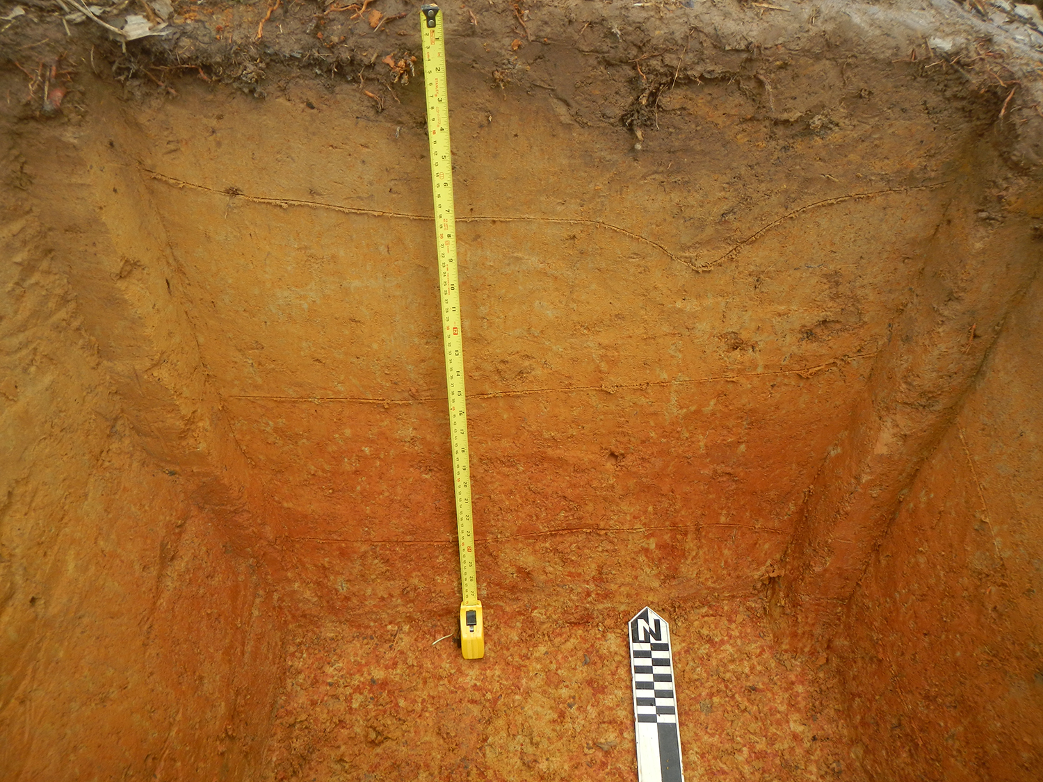
The upper portion of the soil at Guaico Tamana is missing due to the removal of at least 60 cm of sediment from the knoll, which probably contained A1 and A2 horizons. The relict soil profile consists of a disturbed brown (10YR 4/3) silt loam Ap horizon (0–14 cm), underlain by a yellowish brown (10YR 5/6) silt loam AB horizon (14–35 cm) with common yellow (10YR 7/6) mottles, a strong brown (7.5YR 5/8) silty clay loam Bt1 horizon (35–53 cm) with common yellow mottles, and a red (2.5YR 4/8) silty clay loam Bt2 horizon (53–70+ cm) with many yellow mottles (Figure 5). The boundary between the AB and Bt1 horizons is typically relatively smooth and clear, whereas boundaries between the Ap and AB horizons and the Bt1 and Bt2 horizons are distinct and undulating, respectively. Undisturbed artifacts are restricted to the AB and Bt1 horizons. The exact depth at which the Guaico Tamana spearpoint was discovered below the original surface of the bulldozed knoll is unknown. However, one face of the unwashed spearpoint is encrusted with yellowish brown silt and sand, which indicates that it came from somewhere within the AB horizon.
Soil profile in Test Unit 4 (vertical scale: 70 cm). (Color online)

Lithic Assemblage
Chert artifacts were not evenly distributed across the site. Relatively few or no artifacts were found in Test Units 2–3 and 5, which proved to be in disturbed areas. Test Unit 2 was abandoned after removing 18 cm of undisturbed sterile red silty clay loam, confirming that bulldozing penetrated into the Bt2 horizon. Test Unit 3 was excavated to a depth of 70 cm. Only the lower 34 cm comprised undisturbed lower Bt1 and Bt2 deposits, all of which were sterile. Accordingly, knoll leveling across the eastern portion of the site appears to have extended below all cultural deposits. Only two pieces of chert shatter were recovered from Test Unit 5 at depths of 46 and 47 cm. All but the lowermost portion of the cultural deposits in the vicinity of Test Unit 5 were destroyed by the construction of the access road.
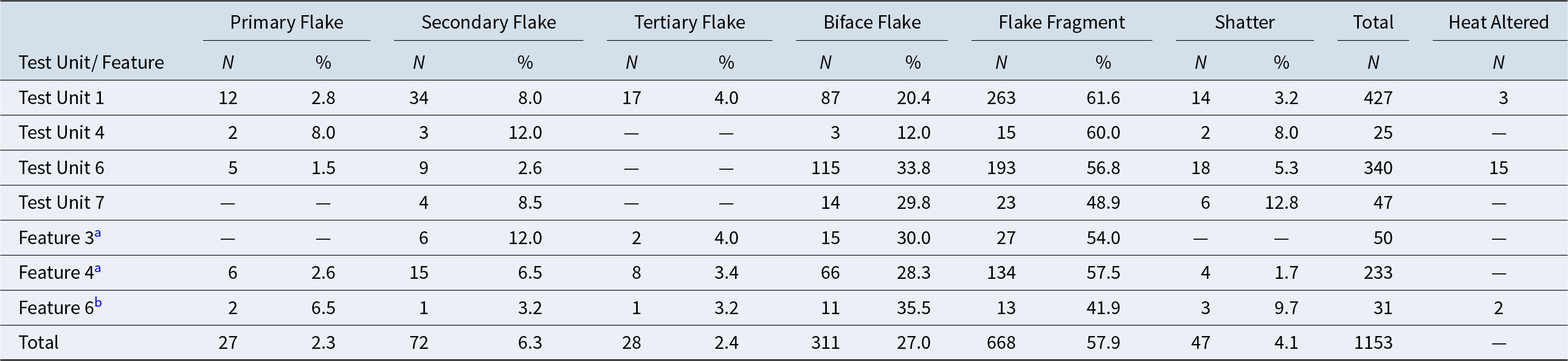
Chert artifacts were concentrated in Test Units 1 and 6 (Figure 3), whereas density decreased significantly 1–3 m to the north in Test Units 4 and 7 (Table 2). In Test Unit 1, in situ artifacts were recovered from the base of the disturbed Ap horizon (18 cm bd) to nearly the base of the Bt1 horizon (62 cm bd). A small quantity of artifacts in Level 7 appears to have been redeposited from overlying levels by bioturbation.
Flake Debitage Types by Test Unit/Feature.

Table 2 Long description
Counts and percentages of flake debitage types are listed for four test units and three features, including primary, secondary, tertiary, biface flakes, flake fragments, shatter, plus totals and heat-altered counts. Overall, flake fragments are most common at 668 pieces, about fifty-eight percent of the 1,153 total, followed by biface flakes at 311 pieces, about twenty-seven percent. Secondary flakes total 72 pieces, primary flakes 27, tertiary flakes 28, and shatter 47, each making up a small share compared with fragments and biface flakes. Test Unit 1 has the largest assemblage at 427 pieces, dominated by flake fragments at 263 and biface flakes at 87, with 3 heat-altered pieces. Test Unit 6 is next at 340 total, also dominated by fragments at 193 and biface flakes at 115, and it has the most heat-altered pieces at 15. Feature 4 totals 233 pieces with a similar pattern, including 134 fragments and 66 biface flakes.
a In Test Unit 6.
b In Test Unit 7.
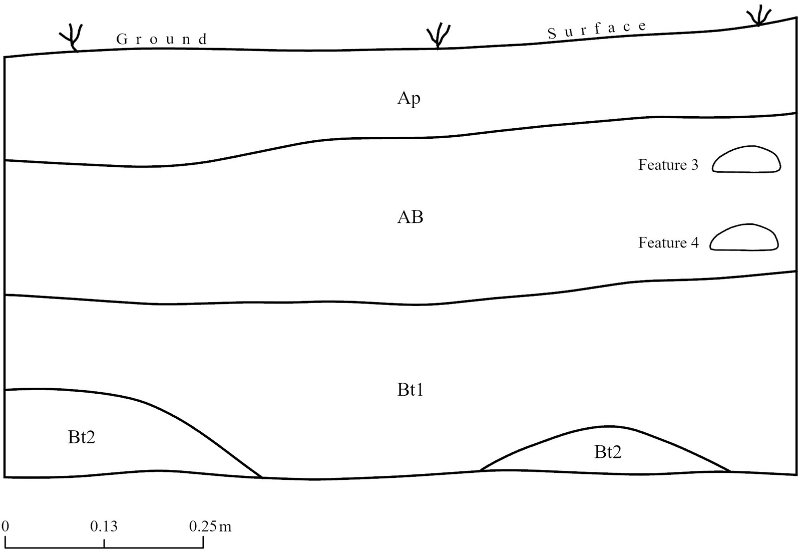
Test Unit 6 (inclusive of Features 3–4) yielded the largest quantity of artifacts from any test unit. Chert flakes appeared at the base of the disturbed Ap horizon and extended to a depth of 50 cm bd. Two distinct knapping features were also identified in the upper half of the test unit (Figure 6). Feature 3 was encountered in the southeast quadrant in the upper portion of the AB horizon between 15 and 19 cm bd and contained 50 flakes indicative of middle-to-late-stage reduction. Feature 4 was discovered in the southwest quadrant in the lower portion of the AB horizon between 24 and 28 cm bd. It was round and measured 35 cm in diameter. This knapping feature contained 233 flakes indicative of early-to-late-stage reduction (Table 2).
Representative stratigraphic profile from Test Unit 6 and relative positions of Features 3 and 4 in the AB horizon (note undulating contact between Bt1 and Bt2 horizons).

Test Unit 7 yielded only 78 chert flakes. These artifacts were recovered between 33 and 55 cm bd in the Bt1 horizon. Feature 6 was discovered in the southwest corner of Test Unit 7 between 39 and 48 cm bd. It measured 26 cm north–south and extended into the west wall. This partial knapping feature contained 31 chert flakes of early-to-late-stage flake debitage. Test Unit 4 contained only 25 chert flakes that were recovered between 12 and 22 cm bd in the upper portion of the AB horizon.
The chipped-stone assemblage from Guaico Tamana was divided into two broad categories: core and flake debitage, and preforms and tools. Only one amorphous core was recovered from the excavations. The general lack of cores suggests that the bulk of the raw material was processed by cobble-blank reduction wherein exterior portions of a cobble were generally discarded as flake debitage as it was thinned, and the core of the cobble was worked into bifacial tool form.
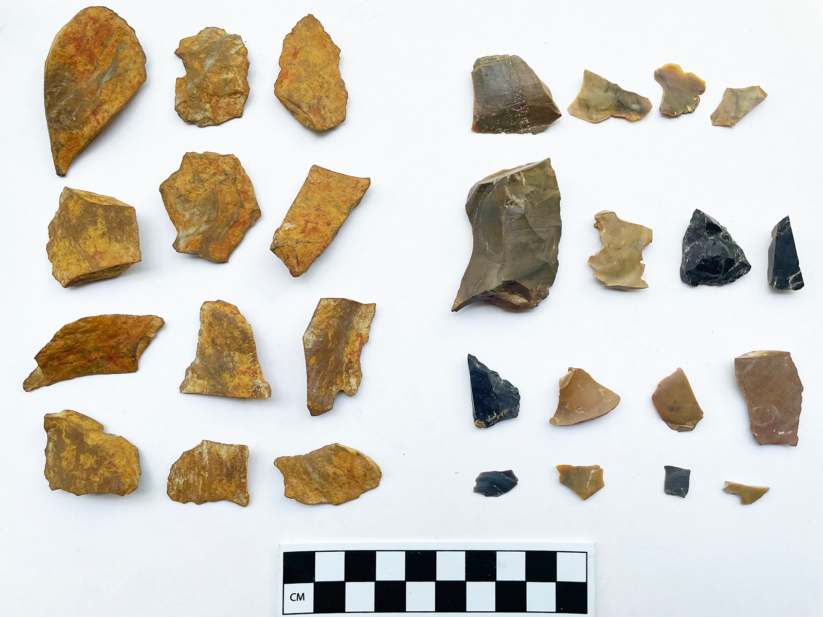
Flake debitage (>1,150 specimens) consists of unutilized flake debris produced as byproducts of flintknapping. The flake debitage was divided into six types (Table 2). Primary flakes (≥50% cortex on dorsal surfaces), secondary flakes (<50% cortex on dorsal surfaces), and tertiary flakes (cortex absent on dorsal surfaces) are generally thick and exhibit flat (unfaceted) platforms, indicative of core reduction or early-stage biface reduction. In contrast, biface flakes typically have little cortex on dorsal surfaces and exhibit lipped and faceted platforms diagnostic of the reduction of bifacial preforms. Compared to primary, secondary, and tertiary flakes, the platforms and bodies of biface flakes are relatively thin and therefore break easily. Flake fragments, the fifth type of sorted flake debitage, are broken flakes that lack striking platforms and are unassignable as to original flake type. Finally, shatter refers to thick angular fragments lacking striking platforms that were produced by cleavage along internal flaws as the raw material was reduced.
Table 2 presents flake debitage from Test Units 1, 4, and 6–7 and Features 3–4 and 6. The majority (58%) of the debitage consists of nondiagnostic flake fragments without platforms. Although these fragments cannot be assigned to original flake type, relatively thin cross sections and general lack of cortex on dorsal surfaces suggest that they most probably represent broken biface flakes. If nondiagnostic flake fragments and shatter are excluded, biface flakes comprise 71% of the remaining flake debitage. Secondary flakes comprise 16.4% of the flake assemblage, whereas primary flakes and tertiary flakes each comprise slightly more than 6%. The high percentage of biface flakes represents controlled percussion flaking of preforms. It contrasts starkly with debitage produced with a hard hammer by bipolar percussion of a cobble on a stone anvil. Bipolar percussion, which involves much less control over the flaking process, produces irregular and thick wedge-shaped flakes and angular shatter, most of which exhibit cortical dorsal surfaces and crushing at one or both ends.
All of the chipped-stone debitage was analyzed as to chert type, which revealed differences in utilization of locally available Chert Hill chert and Malchan Hill chert (Figure 7). This analysis included debitage from Test Units 1 and 6 and Feature 4 that yielded the largest collections. More than 78% of the debitage from Test Unit 1 was knapped from high-quality Malchan Hill chert. The bulk of the debitage was found in Levels 5–6 within the Bt1 horizon and an early occupational level. Conversely, more than 80% of the flake debitage from Test Unit 6 and 93% of the debitage recovered from knapping Feature 4 were manufactured from Chert Hill chert. Feature 4 was discovered in the lower half of the AB horizon, whereas the bulk of the remaining debitage in Test Unit 6 came from Level 4 in the lowermost increments of the AB horizon and the upper portion of the underlying Bt1 horizon. This suggests that the earliest knappers may have preferred to produce chipped-stone tools from higher quality Malchan Hill chert, whereas later knappers may have been less selective of knapping quality and utilized mostly Chert Hill chert. On the other hand, chert exploitation may have been more opportunistic and dependent on which chert cobbles (Malchan Hill or Chert Hill) were exposed by incidental tree throws. It is also possible that knappers from the earliest occupations may have simply chosen to directly access the more abundant and closest primary chert source (Chert Hill) to Guaico Tamana. Heat treatment, which generally improves knapping quality of chert, was not a technology that was used at Guaico Tamana. Only 20 flakes (1.7%) from Guaico Tamana were heat altered (Table 2). All of these appear to have been burned unintentionally by exposure to hearths.
Two chert types utilized at Guaico Tamana: Chert Hill chert from Feature 4 (left), and Malchan Hill chert from Feature 4 and Test Unit 4 (right). (Color online)

Eight bifacial preform fragments (unfinished tools that broke during manufacture) were recovered from Guaico Tamana. These preform fragments were found in each of the four 1 m2 test units (Levels 2–7). The preponderance of biface flakes, multiple broken preform fragments, and three discrete knapping features indicate that the site served as a workshop where chert cobbles were reduced primarily into bifacial tools. Within the boundary of extant cultural deposits, workshop activity was concentrated in the vicinity of Test Units 1 and 6. Workshop activity also likely occurred farther to the east and/or west prior to extensive bulldozer disturbances. Based on the types of flake debitage and broken bifaces, the reduction of bifacial preforms occurred during early-to-late stages of production. Stratigraphic positions of chert flakes, preforms, and lithic features indicate that workshop activity was not a single event but occurred periodically over many decades, centuries, or even a millennium or more.
The recovery of five tools indicates Guaico Tamana was not solely a workshop locale. One graver indicates that bone, wood, and/or other semihard substances were engraved or incised. Three utilized flakes suggest cutting/scraping activities. The contracting-stemmed spearpoint found by Lal’s workers indicates that hunting and/or butchering activities were also performed at or near the site. In addition to the above tools, a chert flake with polish on the dorsal surface found during initial profiling along the road cut suggests that it came from a woodworking or digging tool. These tools suggest that the site may have been periodically cleared and used for short-term habitation in addition to chert procurement and tool manufacture.
Extant artifact-bearing deposits at Guaico Tamana are approximately 50 cm thick and restricted to the AB and Bt1 soil horizons. Considering that at least 60 cm of sediment were removed when the knoll was truncated, it appears that precontact deposits at the site were originally about 1.1 m thick. No in situ cultural material was found in the underlying Bt2 horizon. In situ flake debitage was recovered from the disturbed Ap-undisturbed AB boundary (as high as 12 cm bd) to approximately 62 cm bd in the lower Bt1 horizon (Table 1). An undulating boundary (10–15 cm) between the Bt1 and Bt2 horizons (and presumably an early Holocene ground surface) may account for variable maximum depths of the cultural deposits (Figure 6).
Basal depths of workshop Features 3–4 and 6 (19, 28, and 48 cm bd, respectively) indicate multiple former living surfaces upon which knapping debris accumulated. These surfaces were situated in the upper and lower parts of the AB horizon in Test Unit 6 (Figure 6) and the middle portion of the Bt1 horizon in Test Unit 7, further confirming that workshop activity occurred over time, resulting in stratified deposits. Multiple preform fragments and debitage concentrations also are suggestive of former living surfaces and probably nearby (unencountered) knapping features. For example, two preform fragments and the greatest flake concentration in Test Unit 1 occurred in the lower part of the Bt1 horizon. Although multiple living surfaces are represented, it appears that at a minimum there was an upper (younger) occupation in the AB horizon and a lower (older) occupation in the Bt1 horizon.
Radiocarbon Samples and Ages
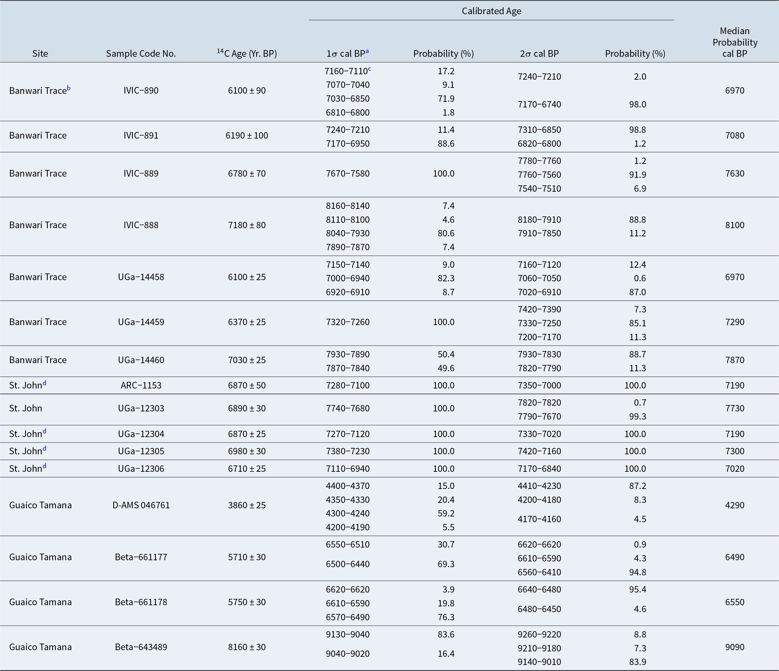
We discovered in 2019 that all of the wood charcoal samples were impregnated with iron deposits, most having pores lined with iron oxide. Nevertheless, several wood charcoal samples were collected in 2022 and 2023, anticipating that radiocarbon laboratories might be able to remove the iron deposits through pretreatment baths. Four of 11 charcoal samples (Field Samples C-6, C-8, C-10, and C-11) obtained in 2022 were submitted to DirectAMS for dating. However, only one sample (C-6) was of sufficient size after pretreatment to yield a radiocarbon age. This sample from the Bt1 horizon of Test Unit 5 yielded a radiocarbon age of 3860 ± 25 BP (D-AMS 046761) with a median probability age of 4290 cal BP using the IntCal20 calibration program (Table 3). This age is much too early for the contracting-stemmed spearpoint found at Guaico Tamana.
Radiocarbon and Calibrated Ages for the Banwari Trace, St. John, and Guaico Tamana Sites.

Table 3 Long description
Radiocarbon ages and calibrated calendar-age ranges are listed for samples from Banwari Trace, St. John, and Guaico Tamana, including median calibrated ages and one-sigma and two-sigma probability ranges. Banwari Trace dates cluster mainly between about 8,160 and 6,850 calibrated years BP, with the oldest Banwari entries around 8,160 to 7,850 cal BP and several later results near 7,160 to 6,910 cal BP. St. John shell samples fall in a similar mid-Holocene window, with calibrated ranges roughly from 7,740 to 6,840 cal BP and medians near 7,730, 7,300, 7,190, and 7,020 cal BP. Guaico Tamana includes both the oldest value in the table, about 9,130 to 9,010 cal BP (median about 9,090), and younger ages around 6,620 to 6,410 cal BP plus a much later set around 4,410 to 4,160 cal BP (median about 4,290). Across sites, most medians concentrate between about 7,900 and 6,900 cal BP, suggesting broadly overlapping activity in that period, while Guaico Tamana extends the sequence to earlier times . Calibrated ranges are sometimes split into multiple intervals with different probabilities, so the median and the highest-probability range may not cover the full uncertainty. Calibration differs by material, with St. John based on marine shell and the others on charcoal, which can affect comparability of calibrated ages.
a Radiocarbon dates converted to cal BP using IntCal20 calendar conversion formulae provided using calib.org/calib/calib.html.
b Radiocarbon ages from Banwari Trace have been obtained from Boomert (Reference Boomert2000:Appendix 3) and Tankersley et alia (Reference Tankersley, Dunning, Owen and Sparks2018:Table 1). For Banwari Trace, they are from Strata II–I only as reported by Boomert (Reference Boomert2000) and Levels 2–3 as reported by Tankersley et alia (Reference Tankersley, Dunning, Owen and Sparks2018). The three earliest ages (IVIC-889, IVIV-888, and UGa-14460) are from the greatest depths at that site.
c All ages are presented using the rounding convention to the nearest 10-year interval, as set forth by the 1977 International Radiocarbon Conference for sites dating between 1,000 and 9,999 years ago (see Stuiver and Polach Reference Stuiver and Polach1977).
d These radiocarbon ages from St. John were derived from marine shells (Marine20 was used for this calibration), whereas all other ages in this table were derived from “charcoal” or, as identified for the Gauico Tamana site, wood charcoal using the IntCal20 calibration program. The last four radiocarbon ages for St. John are from the lower 20 cm of deposits at St. John (see Pagán-Jiménez et al. Reference Pagán-Jiménez, Rodríguez Ramos, Reid, van den Bel and Hofman2015:Table 1).
Three different pretreatment attempts using hydrochloric acid baths to remove the iron-laden sediment followed by rinsing and potassium hydroxide baths were made for Sample C-8 (D-AMS 046762), but it was completely dissolved. Greater caution was used to pretreat Samples C-10 (D-AMS 047368) and C-11 (D-AMS 047369). Unfortunately, a precautionary lab report from DirectAMS concluded that “additional pretreatment attempts are unlikely to yield a clean material that will survive pretreatment.” Afterward, the remaining sediment in the two samples was returned to the authors.
We subsequently contacted Ron Hatfield at Beta Analytic to determine if his company would consider dating any of our samples. After explaining the unusual nature of the samples and the need to treat them with “kid gloves,” Beta Analytic decided to process one sample. In the absence of any additional samples from what were considered good contexts, we decided on the partially processed Sample C-10 from the upper portion of the Bt1 horizon of Test Unit 6. This sample produced an age of 5710 ± 30 BP (Beta-661177) with a median probability age of 6490 cal BP. Still, there remained some uncertainty about the precision of the age relative to the chipped-stone artifacts.
Thirteen additional radiocarbon samples were obtained in 2023, of which 10 were thought to be sufficiently large for dating. Of these, eight were judged to be from good contexts and Samples C-15 and C-16 were selected for submission to Beta for AMS processing. These two processed radiocarbon samples were collected from the south wall of Test Unit 6 to associate radiocarbon ages with sediments located just below the base of workshop Feature 4. Sample C-15, which was recovered from a depth of 33 cm in the lowermost increments of the AB horizon, yielded an age of 5750 ± 30 BP (Beta-661178) with a median probability age of 6550 cal BP. Sample C-16 was collected from a depth of 38 cm in the uppermost increments of the underlying Bt1 horizon. This sample produced an age of 8160 ± 30 BP (Beta-643489) with a median probability age of 9090 ± 30 cal BP (Table 3). This radiocarbon age is probably associated with some of the youngest early Holocene deposits at Guaico Tamana.
The IntCal20 program also was used to generate new ages for the Banwari Trace (Tankersley et al. Reference Tankersley, Dunning, Owen and Sparks2018:Table 1) and St. John sites for better comparison with the early age from the Guaico Tamana site. As Heaton et alia (Reference Heaton, Blaauw, Blackwell, Ramsey, Reimer and Scott2020:822) have noted, the IntCal20 program was developed “to increase robustness and reliability” over previous IntCal programs. Studying the earliest median probability ages from the three sites, we note that the occupation of Guaico Tamana dates at least 1,000 years earlier than that for the Banwari Trace site and 1,300 years earlier than that for the St. John site (Table 3).
Three of the four radiocarbon ages from Guaico Tamana are not concordant with the spearpoint and workshop-related lithic debris. We contend that the dated wood charcoal from these samples likely reflects the mobility of small pieces of charcoal within the sediments as a result of localized bioturbation, as well as episodes of forest clearance for food production and native plant management. In Panama, for example, there is much evidence to indicate that the intensification of forest clearance was accompanied by burning with the inception of swidden farming (Cooke et al. Reference Cooke, Ranere, Pearson and Dickau2013). Although macrobotanical evidence for any level of food production by Archaic peoples of the Ortoiroid series appears to be lacking for Trinidad (see Newsom and Wing Reference Newsom and Wing2004:58), microbotanical evidence in the form of starch grains associated with five artifacts from the St. John site indicates the cultivation of several taxa, including maize, sweet potato, and chili pepper by the early occupants (Pagán-Jiménez et al. Reference Pagán-Jiménez, Rodríguez Ramos, Reid, van den Bel and Hofman2015).
Maize is assigned to the earliest occupation of St. John (Pagán-Jiménez et al. Reference Pagán-Jiménez, Rodríguez Ramos, Reid, van den Bel and Hofman2015:242, Reference Pagán-Jiménez, Rodríguez Ramos, Hofman, Hofman and Antczak2019:90), demonstrating that human-managed swidden farming was already being practiced in southwest Trinidad at least 1,000 years or more before the two Archaic ages of ca. 5700 BP (6470 cal BP) (Beta-661177 and Beta-661178) from Guaico Tamana. The likely island-wide cultivation and management of native plants by relatively early Ortoroid peoples is also supported by pollen, phytolith, and charcoal data in a core obtained from the large Nariva Swamp, located on the eastern side of Trinidad and much closer to Guaico Tamana (<8 km away). Multiple lines of evidence in this core indicate a major transition around 6720 cal BP that reflects the creation of anthropogenic habitats, presumably from both swidden farming and the management of native plants (Siegel et al. Reference Siegel, Jones, Pearsall, Dunning, Farell, Duncan, Curtis and Singh2015:281). It is also notable that the two Archaic ages averaging 6470 cal BP from Guaico Tamana are a few hundred years younger than the earliest evidence for swidden farming from Nariva Swamp.
Discussion
With the discovery and investigation of Guaico Tamana, Banwari Trace no longer represents the earliest site in Trinidad. However, we refrain from touting Guaico Tamana as the earliest archaeological site in the West Indies as was headlined for Banwari Trace by Tankersley et alia (Reference Tankersley, Dunning, Owen and Sparks2018). This is because Trinidad may have been connected to (or recently disconnected from) South America at the time that Guaico Tamana was occupied. Precise dating of the detachment of Trinidad from the South American mainland remains uncertain. Nevertheless, sufficient indirect evidence from sediment cores has accumulated to indicate that Trinidad likely became an island by about 8000 BP (8880 cal BP; Boomert Reference Boomert2000:44, Reference Boomert, Keegan, Hofman and Ramos2013), although some have suggested that it may have occurred as late as ca. 6200–6000 BP (7080–6840 cal BP; Keegan et al. Reference Keegan, Hofman, Rodríguez Ramos, Keegan, Hofman and Ramos2013:4; Van Andel and Sachs Reference Van Andel and Sachs1964).
Analyses of cores into fossil coral reefs have yielded discrete measurements of rapid sea-level rise since the end of the Pleistocene, identifying three major meltwater pulses (Blanchon Reference Blanchon and Hopley2011a, Reference Blanchon and Hopley2011b; Blanchon and Shaw Reference Blanchon and Shaw1995). By around 8800 BP (9820 cal BP), sea level was about 20 m lower than today and terrestrial movement was still possible across the land bridge(s), whereas by around 8200 BP (9140 cal BP) sea level had risen 3 m, thereby disconnecting Trinidad from Venezuela and forming the narrow Gulf of Paria. An abrupt sea-level rise of approximately 0.8–2.2 m associated with drainage of the massive proglacial Lake Agassiz beginning about 8500 and ending 8200 BP (9510–9140 cal BP) (Cooper Reference Cooper, Keegan, Hofman and Ramos2013:54; Li et al. Reference Li, Tornqvist, Nevitt and Kohl2012; Michalek Reference Michalek2013) may have been the final episode that disconnected Trinidad from the mainland. Regardless of when Trinidad was detached from the mainland, those who probably visited Trinidad before it became an island could have still gained easy access to it by the use of dugout canoes, allowing for continued movement of peoples and ideas between the two land masses.
Boomert (Reference Boomert2000:54–75:Figure 7) divided the Ortoiroid series into Banwarian and Ortoiran subseries, and he further separated the Banwarian subseries into Early Banwarian (ca. 8000–7000 BP) and Late Banwarian (ca. 7000–6000 BP). Two Early Banwarian sites (Banwari Trace and St. John) are located in southwest Trinidad (Figure 1). Both are shell middens comprised of freshwater and estuarine snails and other refuse. The earliest deposits at these sites represent the Banwari Trace complex. Bone and stone artifacts and a variety of ground-stone tools for processing wild and cultivated vegetal foods were found in those midden deposits. Both sites produced “small, irregular chips and cores manufactured of quartz, flint, chert and other rock materials by percussion flaking using the bipolar technique,” and “very few flakes appear to have been reworked intentionally by secondary retouch” after detachment from a core (Boomert Reference Boomert2000:58–61). In addition to evidence of bipolar percussion, our examinations of small samples of chert artifacts from the St. Johns site (Ray Reference Ray2015:14) and Banwari Trace also revealed the production of cortical flake blanks by direct freehand percussion that were probably used for expedient cutting and scraping purposes. The presence of core and flake blank debitage indicative of freehand percussion, thick wedge-shaped flakes and angular shatter indicative of bipolar percussion, and an absence of biface flakes together indicate that the early Banwari Trace complex lacked full-facial biface-reduction technology. Boomert (Reference Boomert2000:66–67) also discussed five Banwarian Archaic sites that produced “flint deposits.” However, based on artifact descriptions, none of the chert artifacts from these sites has provided evidence for biface reduction.
Due to differences in technologies and economic strategies adapted to changing environmental settings, we propose a new Early Archaic complex called the “Guaico Tamana complex” that succeeded the El Jobo complex of Paleoamerican times and preceded the Early Banwari Trace complex. The Guaico Tamana complex is currently restricted to the eastern portion of the Central Range that contains abundant deposits of relatively low-grade Chert Hill chert and localized deposits of high-grade Malchan Hill chert. Presently, the Guaico Tamana complex includes components from only two sites—Guaico Tamana and Biche. Nevertheless, additional undiscovered sites representative of the complex are likely present in the Central Range, if not other portions of Trinidad. We suggest the Guaico Tamana complex encompasses an early Holocene temporal span of about 9500–8000 BP (10,750–8880 cal BP) when Trinidad was still connected to or recently disconnected from the South American continent. A full occupational range for Guaico Tamana is unclear. A single radiocarbon age indicates that the site was occupied during the latter end of the above time frame. However, artifacts recovered from the middle and lower parts of the Bt1 horizon provide evidence of earlier site use. At the close of the Guaico Tamana complex and the end of the early Holocene, it appears that contracting-stemmed points and bifacial reduction strategies in general disappeared from Trinidad and much of northern South America.
Subsistence practices of the Guaico Tamana complex likely shifted from specialized hunting of Pleistocene big-game animals to small-game hunting and a more intensive focus on collecting local plant and animal resources. The two spearpoints recovered from Biche and Guaico Tamana clearly reflect the hunting of terrestrial mammals (e.g., red brocket deer and collared peccary), perhaps those thriving in the more extensive savannas and adjacent forested margins that existed in Trinidad during terminal Pleistocene and early Holocene times (Beard Reference Beard1946; Farrell et al. Reference Farrell, Duncan, Jones, Dunning, Pearsall and Siegel2018; Watts Reference Watts1987). Guaico Tamana inhabitants may have periodically burned the landscape to manage and expand the savannas. Lack of faunal remains at the Guaico Tamana site is due to acidic soil and the absence of neutralizing shell deposits. Whereas a terrestrial hunting-based economy could be inferred for the occupants of Guaico Tamana, the potential importance of foraging for other terrestrial resources should not be ignored given the great biodiversity characterizing Trinidad.
The settlement pattern of the Guaico Tamana complex is poorly understood at this time. Both Guaico Tamana and Biche are located less than 6 km apart in the rolling hills that comprise the southern flank of the Central Range. There is no evidence for sustained occupations typical of base camps. Mobile groups probably lived in short-term temporary camps located in productive hunting grounds that contained abundant and localized chert resources used for the expedient production of spearpoints and other chipped-stone tools. Our investigations at Guaico Tamana confirm a temporary camp and lithic workshop established for the exploitation of local chert deposits, possibly discovered in uprooted tree throws while hunting. Extant deposits contain discrete lithic reduction knapping features. However, prior to large-scale historic disturbances at Guaico Tamana, additional specialized activity areas could have been present in other portions of the site as suggested by expedient flake tools, a graver, and a polished flake suggestive of woodworking (e.g., possibly for tree clearing) or digging (possibly for procuring tubers or buried chert cobbles). Due to complete destruction, it is uncertain whether the Biche site represents another temporary campsite or if the associated spearpoint simply represents an isolated find lost during a hunt.
We contend that the earliest peoples that occupied Guaico Tamana were not rare nomadic hunters who visited the island now and then, but one group among others who were scattered about the island with well-established short-term settlements, possibly representing a regional settling-in process during the early Holocene. The number of identified sites in Trinidad is vastly underrepresented in comparison to several other islands in the Lesser Antilles (Lopinot and Ray Reference Lopinot and Ray2018:36–37). The site number for the Guaico Tamana site is only SAN-11, whereas St. Andrew County encompasses 740 km2. Given that it is the last site recorded for that county, then only one site per 67.3 km2 has been recorded for all of St. Andrew County. In fact, Lopinot and Ray (Reference Lopinot and Ray2018:36) indicated that, when an “inventory of known Amerindian sites in Trinidad numbered 209 (which includes 72 individual finds) as of a Boomert and Harris (Reference Boomert and O’Brien Harris1988) overview, . . . that amounts to one site per 23.1 km2 (Boomert Reference Boomert2000:12). Excluding isolated finds, that equates to one site per 34.8 km2.”
The lithic technology of the Guaico Tamana complex was based on bifacial reduction and the production of large spearpoints for hunting local fauna of the early Holocene. The presence of multiple discrete knapping features, a preponderance of biface flakes, and the recovery of several failed early-to-late-stage preform fragments from multiple horizons at Guaico Tamana constitute direct evidence that workshop activity was focused on the production of complex bifacial tools. In addition to its position on an ecotonal boundary between an inland forest and the Nariva Swamp, proximity to high-quality toolstone resources may have made Guaico Tamana attractive for temporary occupations. Early hunters may have been largely tethered to the east-central region of the Central Range where large sources of chipped-stone raw materials like those at Chert Hill and Malchan Hill can be found. Unlike those two sources, the localized chert deposits at Guaico Tamana represent a much smaller and less significant source. As such, chert procurement may have been opportunistic and based on incidental exposure of cobbles in the rootwads of large toppled trees. Once exposed, those chert cobbles could have been targeted during short periods of small-scale quarrying. The presence of nearly 100 decortication flakes in the workshop debitage at Guaico Tamana indicates some on-site cortex removal and cobble reduction.
The two contracting-stemmed spearpoints from Guaico Tamana and Biche are remarkably similar in form and manufacturing techniques. Both were shaped by systematic soft-hammer, full-bifacial percussion flaking, whereas edges were finished by controlled pressure flaking. Stems are long (25–30 mm) and contract to a pointed base, which were inserted into narrow sockets and bound with resin or tar pitch. Differences in blade shape and length probably reflect varying degrees of blade resharpening. The production of complicated tools such as spearpoints was replaced with the production of flake blanks by freehand percussion and bipolar percussion sometime between approximately 8000 and 7200 BP (8800–8000 cal BP). This technological change may have occurred during a shift from a primarily hunting-gathering economy prior to 8000 BP (8880 cal BP) to an economy focused primarily on processing vegetal foods supplemented with the hunting of small mammals, fishing, and collecting shellfish by 7200 BP (8000 cal BP; Boomert Reference Boomert2000:57–58). The change in technologies and associated economies may have coincided with the change in environmental ecosystems (i.e., terrestrial to marine) when a fully inundated Gulf of Paria disconnected Trinidad from the mainland.
During early Holocene times there was a change in bifacial technologies from producing long, narrow, unstemmed, lanceolate (El Jobo) spearpoints to making wide-bladed spearpoints with distinct, narrower, haft (stem) elements that were straight or contracting. These stemmed points have been associated with the Fishtail and Paijan complexes commonly found in Peru and adjacent areas (Dillehay Reference Dillehay, Silverman and Isbell2008; Dillehay et al. Reference Dillehay, Rossen, Maggard, Stackelbeck and Netherly2003; Maggard Reference Maggard2010, Reference Maggard2015). Hunting implements associated with the younger Paijan complex have been divided into four varieties of spearpoints (Maggard Reference Maggard2015:32–36). Early Paijan points generally exhibit straight stems with straight to slightly convex bases, whereas Late Paijan points have contracting stems with rounded or pointed bases. A Contracting Narrow Stem variety, essentially identical to the two contracting-stemmed points found in Trinidad, is associated with a Late Paijan subphase that ranges between about 10,000 and 8500 BP (11,470–9510 cal BP; Dillehay Reference Dillehay, Silverman and Isbell2008:38; Maggard Reference Maggard2010:364–377, Reference Maggard2015:34). Although Paijan points are typically associated with the coastal and highland areas of Peru, the technology of manufacturing stemmed spearpoints likely spread rapidly throughout northern South America (Dillehay Reference Dillehay, Silverman and Isbell2008:40). Contracting-stemmed points from an unnamed complex similar to Paijan and that from Trinidad have been documented in Colombia, where one specimen has been associated with an age range of 8500–8000 BP (9510–8880 cal BP; Aceituno et al. Reference Aceituno, Loaiza, Degado-Burbano and Barrientos2013:28–30, Figure 5). Other contracting-stemmed points from northern Venezuela have been grouped into the Las Casitas tradition that succeeded the El Jobo tradition (Arroyo et al. Reference Arroyo, Miguel, María Cruxent and de Atencio1971; Vargas et al. Reference Vargas, Verger, Wiesenberg, von Buren, Carrillo-Briceno, Jaimes and Sanchez-Villagra2025). Primary agents in the dispersal of the early Holocene stemmed tradition likely occurred via dugout canoes travelling major waterway systems, particularly those of the Amazon and Orinoco Rivers.
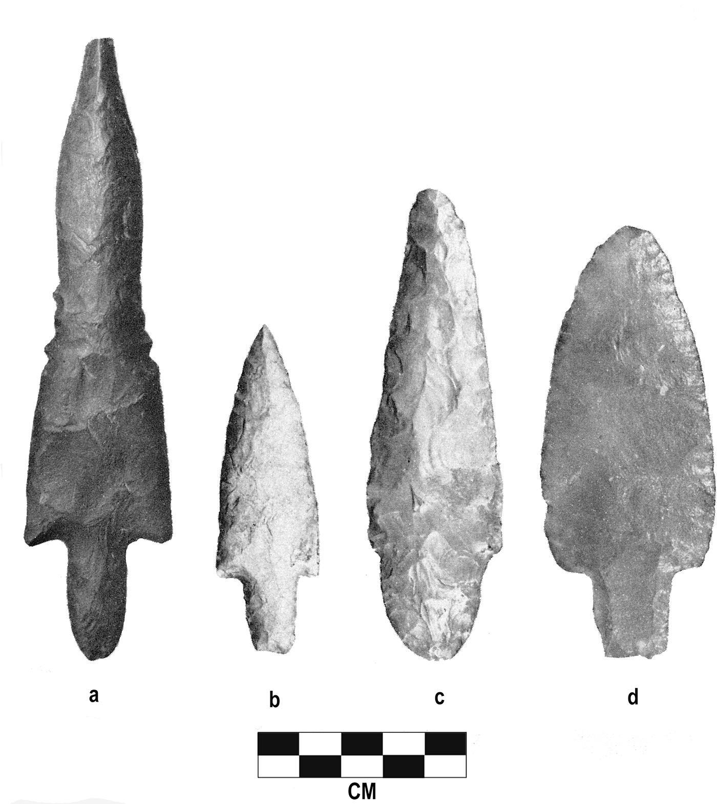
The Guaico Tamana complex could have originated or descended from cultural entities in neighboring areas of northern South America (south or west of Trinidad) where several contracting-stemmed points like those found in the Central Range have been reported (Boomert Reference Boomert2000:49–51). These stemmed points have been found within and on both sides of the Orinoco River basin (i.e., the Coastal Range of northern Venezuela southeast to the Guiana Highlands). Similar to the specimens from Biche and Guaico Tamana, the vast majority have been surface finds or come from disturbed contexts, and many have been accidental discoveries. The Canaima site located in the upper Caroni River valley of eastern Venezuela produced several stemmed spearpoints, at least six of which have contracting stems with pointed bases (Figure 8; Boomert Reference Boomert2000:49–51; Rouse and Cruxent Reference Rouse and Cruxent1963:Plate 6). Relatively crude flaking on some of them may be related to the inferior knapping quality of locally available raw materials. Rouse and Cruxent (Reference Rouse and Cruxent1963:42–43) characterized the site as a camp or workshop and indicated that in addition to spearpoints, the Canaima Complex includes plano-convex scrapers and hammerstones. Four contracting-stemmed points (two with rounded bases and two with truncated bases) have been recovered from the Cuyuni River in Guyana (Evans and Meggers Reference Evans and Meggers1960:21–22, Plate 8). Three of these are depicted in Figure 9b–d. Another long contracting-stemmed point with a pointed base was recovered from the Ireng River valley in western Guyana (Figure 9a; Evans and Meggers Reference Evans and Meggers1960:Plate 8a). Similar contracting-stemmed points (some with truncated bases) and other artifacts that comprise the Early Sipaliwini complex have been documented in southern Suriname (Boomert Reference Boomert2000:50; Harris Reference Harris, Cummins and King1991: Figure 9c). Hunting-gathering cultures like the above have also been found in Brazilian Guiana, where the Carajas complex has been radiocarbon dated to about 8140 BP (9070 cal BP; Boomert Reference Boomert2000:69), and in southeast Brazil, where a Rioclarense industry that produced small contracting-stemmed points has been associated with Early Holocene ages (Moreno de Sousa and Okumura Reference Moreno de Sousa and Okumura2020:2).
Contracting-stemmed spearpoints of the Canaima Complex from eastern Venezuela (from Rouse and Cruxent Reference Rouse and Cruxent1963:Plate 6).

Contracting-stemmed points from Guyana (adapted from Evans and Meggers Reference Evans and Meggers1960:Plate 8).

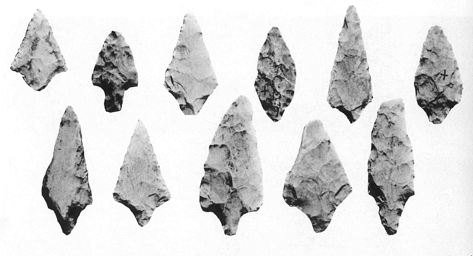
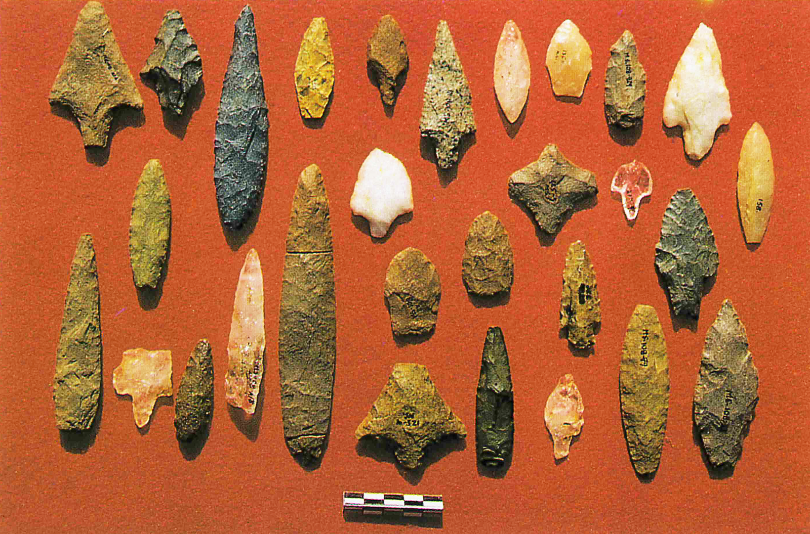
Two contracting-stemmed spearpoints like those found at Canaima were recovered from the Culebra site near the Atures Rapids in the upper Orinoco River valley (Barse Reference Barse1990:Figure 3e–f, Reference Barse and Mercader2003; Boomert Reference Boomert2000:50–51). Barse (Reference Barse1990:1388–1389) defined an Atures complex that included these spearpoints, core fragments, spoke shaves, and flake scrapers. Barse also investigated the Provincial site located 37 km north of Culebra. Although no projectile points were recovered, Barse reported a radiocarbon age of 9020 ± 100 BP from a paleosol that contained ground-stone tools and three quartz flakes. The Las Casitas site near Caracas has also produced contracting-stemmed points with rounded bases (Rouse and Cruxent Reference Rouse and Cruxent1963:33–34, Plate 3g). Other artifacts associated with the Las Casitas complex include choppers, knives, scrapers, and hammerstones (Boomert Reference Boomert2000:51). Szabadics Roka (Reference Szabadics Roka1997) accumulated a large collection of chipped-stone artifacts across northern Venezuela. At least 14 spearpoints have contracting stems with pointed, rounded, and straight bases (Figure 10; Szabadics Roka Reference Szabadics Roka1997:Figures 44–45, Photo 78). Specific proveniences are not provided for all. However, two were found on Margarita Island off the coast of the Paria peninsula, one came from the Las Casitas site, and one was recovered from the Geraldino River area.
Contracting-stemmed and unstemmed spearpoints from northern Venezuela (from Szabadics Roka Reference Szabadics Roka1997:Photo 78; original photograph by Eva Hofle). Contracting-stemmed points at upper left corner and upper right corner are from Margarita Island. (Color online)

It is clear from available data that stemmed spearpoints with prominent shoulders were widely distributed across northern South America during Early Archaic times around 10,000–8000 BP (11,470–8880 cal BP; Aceituno et al. Reference Aceituno, Loaiza, Degado-Burbano and Barrientos2013:29; Boomert Reference Boomert2000:69; Maggard Reference Maggard2010, Reference Maggard2015). Compared to preceding late Pleistocene times, an increase in the number of sites that has yielded stemmed points suggests that human populations increased across this area during early Holocene times. Unfortunately, morphometric measurements for most of these hafted bifaces are currently unavailable. The stems and bases of these points differ slightly in form. Contracting stems appear to be most common, although some have straight stems. Stem widths range from broad to narrow, whereas bases are convex (rounded/pointed) or straight (truncated). It is reasonable to assume that morphological variations developed over such a broad area of the continent, producing regional varieties within a panregional theme of stemmed and socketed spearpoints. These variations may represent a complex set of cultural expressions driven by social changes as well as by adaptations to shifting local environmental conditions. These expressions may have been contemporaneous or successional. Other than the Paijan tradition in Peru, an unnamed complex in Colombia, and the Carajas complex of Brazilian Guiana, temporal (radiometric) parameters for stemmed points across most of South America are poorly established. It is possible that some variation in stem morphology may have developed over time similar to the early and late forms of the Paijan complex. Some variations in form, size, and thickness also may have resulted from the highly variable knapping qualities and sizes of locally available raw materials. In other words, complex bifacially flaked spearpoints made from inferior quality stones are likely to differ in terms of form, size, and thickness compared to those made from more fine-grained siliceous material such as chert.
Closing
Boomert (Reference Boomert2000:49) affiliated the spearpoint found at Biche with the Joboid series (Rouse and Cruxent Reference Rouse and Cruxent1963:28–34), which dates to late Pleistocene times. We suggest that any references to the contracting-stemmed points from the Central Range as being Joboid should be avoided. Aside from differences in haft element (unstemmed lanceolate vs. contracting stemmed), radiocarbon ages associated with late Pleistocene El Jobo sites are several thousand years older than the early Holocene radiocarbon age from Guaico Tamana. The contracting-stemmed spearpoints with pointed bases and prominent shoulders from the Biche and Guaico Tamana sites compare favorably with contracting-stemmed points found across northern South America. The earliest radiocarbon age from Guaico Tamana overlaps with those assigned to the Carajas complex, an unnamed complex in Colombia, and the Late Paijan complex (especially the Contracting Narrow Stem variety). Yet we are reluctant at this time to assign the two contracting-stemmed points from Trinidad to a specific defined point type. We contend that substantially larger samples of contracting-stemmed projectile points from well-dated sites in northern South America and Trinidad are needed to better understand the morphometric attributes and variability for regional point-type classification. Future discoveries of early stemmed point types may ultimately indicate multiple chronologically and geographically distinct projectile point types, or they may indicate slight regional variations (phases) of a panregional entity focused on a lithic tradition of producing contracting-stemmed points. Intensive surveys along coastal and inland regions combined with targeted deep testing of relict late Pleistocene to early Holocene landforms are needed to discover additional early sites that may contain larger samples of contracting-stemmed points from discrete stratified contexts. Such discoveries could fine-tune our understanding of the earliest (and succeeding) inhabitants of Trinidad.
Documentation of a biface-reduction technology was nonexistent in Trinidad prior to the investigation of the Guaico Tamana site. The spearpoint found at Biche was representative of such a technology, but in the absence of any context or associated chert debitage at the Biche site, it could be argued that it represents a curated tool transported to Trinidad from the mainland. The Guaico Tamana site and that at nearby Biche comprise an Early Archaic Guaico Tamana complex that could be restricted to Trinidad and the formerly connected Paria peninsula of Venezuela, while also belonging to a larger panregional cultural expression or tradition that extended across much of northern South America around 9500–8000 BP (10,750–8880 cal BP). Radiocarbon ages from Guaico Tamana are not in stratigraphic order probably due to long-term postdepositional mixing of small particles via bioturbation processes and possibly swidden farming. Nevertheless, we are confident that sediments in the AB and Bt1 horizons at Guaico Tamana are early Holocene in age. First, chert artifacts found throughout these two soil horizons are indicative of bifacial reduction, a technology confined to the Early Archaic and earlier times in Trinidad and the adjacent mainland. Seven bifacial preform fragments were recovered from both horizons, and more than 70% of all recovered flakes that retain a platform are biface flakes. Second, three undisturbed discrete knapping features were found in the upper and lower portions of the AB horizon and the middle portion of the Bt1 horizon. Between 65% and 73% of flakes with platforms from these features consisted of biface flakes. Third, remnant sediment on one face of the contracting-stemmed spearpoint indicates that it was displaced from the AB horizon. Fourth, Guaico Tamana yielded no evidence of bipolar percussion, a lithic-reduction technique that appears approximately a millennium later during Early Banwarian times.
Chert debitage and broken preforms scattered throughout the AB and Bt1 horizons and three lithic workshop features stratified in both indicate that lithic reduction occurred sequentially over time with the oldest occupation in the lower part of the Bt1 horizon and the youngest occupation at the top of the AB horizon. Accordingly, we believe that the contracting-stemmed point and the radiocarbon age of 8160 ± 30 BP (9090 ± 30 cal BP) are probably associated with one or more of the younger occupations. If so, the deposits near the bottom of the Bt1 horizon could be substantially older. Available evidence indicates that site use in early Holocene times was primarily as a lithic workshop where local chert deposits and possibly some from larger nearby chert sources were targeted. Associated occupations were probably short-term and likely included hunting and gathering of local plant and animal resources.
Finally, three radiocarbon ages indicate that Guaico Tamana was probably utilized repeatedly (over thousands of years) during post-Late Banwarian (i.e., Late Archaic) times. Except for small redeposited wood charcoal fragments, any evidence associated with post-Early Archaic occupations appears to have been removed when the elliptical knoll was mechanically leveled. Whereas the earliest known occupations were hunter-gatherers producing contracting-stemmed spearpoints, later site use around 5700 and 3900 BP (6470–4350 cal BP) apparently involved swidden farming.
Acknowledgments
First, we would like to express our deep appreciation and gratitude to Kishore Lal, owner of the Guaico Tamana site. Without his permission, we would not have been able to investigate this site. Kishore also provided important information regarding the discovery of the contracting-stemmed spearpoint and various aspects of the site and its surroundings. Second, we acknowledge Glen Wilkes, who mentioned the chert spearpoint while meeting the corresponding author in northeast Trinidad, at which time he provided contact information for Kishore. We also thank Ignatious Hudson Johnson, owner of the property where the Biche point was found, for allowing us to reinvestigate his property; Dustin Thompson, who prepared Figures 1, 4, and 6; and Lisa Burton, who prepared Figure 9. Permission to use original photographs and illustrations were provided by Yale University Press and Yenny Szabadics. Lastly, those who assisted with fieldwork at the Guaico Tamana site (in order of their contribution) were Rufus (Ian) Garcia, Matt Nowak, Cheryl Garcia, Yvette Garcia, Brittaney London, Ashleigh Morris, and Zara Ali.
Funding Statement
We would like to thank the many sources of funding that allowed us to continue our research in Trinidad and Tobago intermittently since 2003. These have included the Archaeology Committee of the Ministry of Community Development, Culture, and Gender Affairs, Office of the Prime Minister, Republic of Trinidad & Tobago; National Trust of Trinidad and Tobago; US Embassy of Trinidad and Tobago; and Missouri State University’s former Latin American, Caribbean, and Hispanic Studies (LACHS) Program, Faculty Research Grants Program, and Center for Archaeological Research.
Data Availability Statement
The materials that are the subject of this study along with associated documentary records are curated at the Archaeology Centre, University of the West Indies, St. Augustine, Trinidad.
Competing Interests
The authors declare no competing interests.