

Introduction
The project from which this article is drawn began as a conventional history of agriculture in nineteenth-century Tamilnad. What made it a conventional history was its focus on the state and the class structure, the two great themes in the agrarian history of India. The focus on the state may be traced back to efforts to understand the nature of Mughal rule—was it an Oriental despotism?—and the impact of British colonial revenue systems. The interest in the class structure has its origins in Marxism, in particular works such as Maurice Dobb's Studies in the Development of Capitalism, whose influence may be seen in Irfan Habib's Agrarian System of Mughal India, and Lenin's Development of Capitalism in Russia, which had a profound impact on the study of colonial India.Footnote 1
With a focus on states and classes, the environment of India and its impact on agriculture has been neglected, except to provide a context—which is largely unchanging—in which states extracted and classes struggled. One example of environment as the backdrop is the distinction between ‘wet’ and ‘dry’ areas in Tamilnad and South India more widely. This distinction is based on the availability of water and on the local categorization of agricultural activity (nanjai versus punjai). There are two problems with this approach, however. First, it is a narrow treatment of the environment as it neglects other features of the land such as forests, grasslands, scrublands, and other so-called wasteland. Second, it sees the environment as fixed, but the landscape changed dramatically in the past, especially in the nineteenth and twentieth centuries.
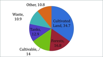
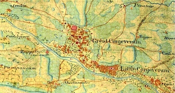
If changes in the environment are included in the mix, the development of agriculture in nineteenth-century Tamilnad may be seen in some new ways. Agricultural production existed in symbiosis with the complex and varied environment of the region. In the early nineteenth century Tamilnad contained extensive tracts of forests, widespread wasteland, and abundant surface water. This diverse environment made it possible to maintain high levels of agricultural productivity as it provided the resources to maintain the fertility of the soil and the supplies of water that were critical for agricultural enterprise, as well as the well-being of the rural population. The diversity of the landscape may be seen in Figure 1, which is based on the Barnard Survey and gives us a picture of land use in Chingleput in the late 1760s. As can be seen here, only a third of the land was under cultivation, with another sixth cultivable. Sixteen per cent of the land area was covered by woods or forests and 13 per cent was under water, while the remainder was devoted to human habitation, waste, and uncultivable land.
Land use in Chingleput, circa the late 1760s.

Water
Water is life in Tamilnad. For more than a millennium enormous energy and ingenuity have been devoted to moving and storing this vital substance. These efforts reshaped the landscape of the Tamil country, which, by the nineteenth century, was carpeted with tanks and criss-crossed by a vast network of canals and channels. These waterworks are striking evidence that the land, and thus the environment, of Tamilnad, were shaped by human activity. Given this, it is no surprise that water has been critical for understanding the geography, environment, and agriculture of the Tamil region in the longue durée. In numerous accounts the landscape of Tamilnad is divided into two zones—the wet and dry or valleys and plains—in which the availability of water is seen as crucial not only for the agrarian economy but also social, political, and cultural life.
There is no disputing the centrality of water in Tamilnad, but it alone did not define the landscape, nor was it the only link between agriculture and the environment. In addition to waterways, both natural and human made, and the many thousands of tanks that ranged in size from small ponds to giant lakes, the Tamil country featured forests, grasslands, and so-called wastelands that were home to their own environments, hills, and mountains, and a long coastline with marshes and mangroves. All of these shaped the agrarian economy of the region. Outside the great delta of the Cauvery River and, to a lesser extent, the valley of the Tambraparni River, which contained a seemingly unending vista of paddy fields, the areas of cultivation were like ponds in a larger and diverse ecosystem. Recall that in Chingleput in the late 1760s only a third of the land was under cultivation (see Figure 1).
The broader environment and its implications for agricultural production in Tamilnad is the concern of the project from which this article is drawn. The present exercise will focus on water, but it departs from the categorization of the geography and the agrarian economy into wet and dry or valleys and plains. Instead it looks at the agricultural system and the environment from the perspective of forms of water control. This highlights the centrality of tanks in large parts of Tamilnad. Tanks were critical in the mixed zones where irrigated and unirrigated fields were found in close proximity and often side by side. Tanks were also critical in river valleys, with the exception of the Cauvery. From the early nineteenth century on, tanks went into slow decline, and from the closing decades of the century these forms of water control began to be replaced by wells. This shift, from the storage of the waters of the monsoon to tapping underground supplies, transformed both the agriculture and the environment of Tamilnad.
Wet and dry in Tamil country
The centrality of water for agriculture in the region is reflected in the Tamil distinction between nanjai and punjai, or wet and dry cultivation. Nanjai designated irrigated cultivation, most typically of rice, while punjai referred to the unirrigated cultivation of millets as well as cash crops such as cotton. In the Tamil imaginary the former was associated with prosperity and the latter with bare-bones subsistence.
David Washbrook drew upon this agricultural distinction between nanjai and punjai and divided the Madras Presidency into wet and dry districts, a division which formed the foundation for his examination of country and provincial politics in South India between 1870 and 1920. Wet and dry areas had strikingly different forms of peasant life and social and economic organization, which gave rise to very different forms of political activity. Washbrook recognized that not all wet areas were alike and he contrasted Tanjore and Malabar, on the one hand, with the Godavari and Krishna deltas, on the other. He also recognized that the designation ‘dry district’ was an imperfect category. He wrote, ‘As the “dry” region is categorized by a type of cultivation, it is not meant to include those parts of “dry” districts in which “wet” rice cultivation was to be found. In the districts of hinterland Tamilnad it thus excludes about 20 per cent of Tinnevelly, Trichinopoly and Madura where rice cultivation took place along the banks of rivers and large tanks.’Footnote 2
The distinction between nanjai and punjai was the basis for David Ludden's mapping of agricultural activity in the Tirunelveli region of Tamilnad in the longue durée. Nanjai cultivation centred on the valley of the Tambraparni River, which formed the wet zone. To the north and south of the river lay areas of punjai cultivation, which Ludden called the dry zones. He also identified a third type of cultivation (which he called ‘mixed’) where lands irrigated by tanks—many filled with the runoff water from nearby hills—were interspersed with fields that were home to millets raised on rainfall alone. Another form of mixed cultivation, which drew upon Tamil categorization of cultivation, was nanjai-mel-punjai in which unirrigated cultivation was undertaken on lands that were classified as wet.Footnote 3
Christopher Baker extended this distinction between wet and dry to Tamilnad as a whole and divided the Tamil landscape into valleys and plains. The former were home to irrigated rice agriculture and the latter to unirrigated millet and cash crop cultivation. Baker added a third area, Kongunad, which encompassed parts of Coimbatore and Salem and shared features of both the valleys and the plains. It was ‘sufficiently distinctive’ to form its own category of land, however. The physical geography of Kongunad resembled that of the plains, but it had more plentiful supplies of subsurface water which could be tapped with wells, creating more scope for irrigation, as in the valleys.Footnote 4
Not all historians of agrarian Tamilnad subscribe to the wet versus dry distinction. Arun Bandopadhyay, for instance, has criticized this division because it is too broad and ‘ignore[s] significant local variations’.Footnote 5 He argues for combining physical conditions with soils and cropping patterns to produce a ‘more fruitful, broader division’, but his efforts do not yield a framework that illuminates the complex changes in the Tamilnad countryside in the first half of the nineteenth century, which is his temporal focus.Footnote 6 His taxonomy is too unwieldy and too localized to aid in drawing larger conclusions.
This article retains the focus on water as the heart of the agrarian economy in nineteenth-century Tamilnad. However, it departs from the wet-dry distinction that has prevailed in the literature. One problem with this distinction is that it is not rooted in a Tamil categorization of the landscape. Instead, it projects categories of cultivation onto geography. Tamil classification of the land rests on the classical five-fold scheme of kurinji (hills), mullai (forests), marutham (arable), neythal (seashore), and palai (desert). This classification shows that the nanjai and punjai division is not faithful to Tamil understandings of the landscape. It also shows that Tamils situated agricultural activity within a broader environment which contained hills, forests, sea, and desert.
Further evidence for the limits of the wet versus dry distinction comes from the writings of Kalki Krishnamurthy who on several occasions describes mirasidars (the Persian term for the Tamil kaniyatchikarar or holder of property rights in land or its produce) as possessing holdings that comprised plots of nanjai along with punjai. In the wet-dry scheme, a mirasidar is assumed to be a high-caste controller of nanjai lands in irrigated river valleys, but in Kalki's hands he could be a proprietor of both punjai and nanjai.
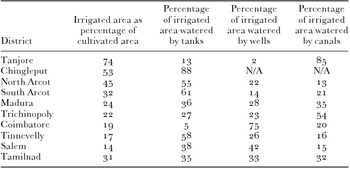
To make sense of Kalki's mirasidars we must return to Ludden's category of the mixed zone in which irrigated and unirrigated cultivation could be found in close proximity to each other and quite frequently located side by side. Once the great extent of these mixed zones is appreciated, it becomes evident that only a few areas of Tamilnad can be easily characterized as either wet or dry. Tanjore, for instance, is exceptional for its secure and abundant water supplies and, as can be seen from Table 1, in the early twentieth century three-quarters of the cultivated area of that district was irrigated. On the other end of the spectrum, Salem was almost completely dry with only 14 per cent of cultivated area under irrigation in the early twentieth century. These two districts occupy the two poles, so to speak, of the wet-dry spectrum, but in-between we find arrayed the other districts of Tamilnad.
Irrigation in Tamilnad, circa 1900.

Source: Imperial Gazetteer of India Provincial Series, Madras, 2 vols (Calcutta, 1908).
In these districts we may point to areas that are clearly wet or dry. As already discussed, in Tinnevelly, the valley of the Tambraparni was clearly a wet area which was abutted by dry areas to the north and the south. Similarly in Trichinopoly, the lands that lay in proximity to the waters of the Cauvery were centres of rice cultivation, while areas that lay at a distance from the river were home to millets of various kinds.
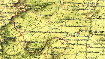
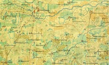
At the same time both Tinnevelly and Trichinopoly contained substantial tracts of mixed cultivation. And in both areas much of these mixed lands lay adjacent to hills where rainwater was stored easily in tanks. The large number of tanks in this part of Trichinopoly district is evident from Map 1, which is a part of an early map of the district undertaken by the trigonometrical survey of India and dates to about 1820. Other districts also contained extensive lands of mixed cultivation, which may be seen in Maps 2, 3, and 4, which are drawn from the same early nineteenth-century trigonometrical survey. In each of these maps, dry fields are juxtaposed with wet. In Map 2, which comes from Dindigul, irrigated rice fields abut tanks, and abutting both are unirrigated fields. And similarly, in Maps 3 and 4, which are from South Arcot and Chingleput, respectively, we can see the mixed nature of agriculture. In fact, the whole of Chingleput district may be considered a mixed zone.
Northwestern Trichinopoly district, circa 1820. A number of tanks are located adjacent to the hills which dotted the northwestern part of the district. Source: Map X/2536, Africa, Asia and Pacific Collections, British Library, London.

A portion of Dindigul, circa 1820. The squares adjacent to the rivers and tanks mark rice fields. The criss-crossed areas are dry or unirrigated fields. Source: Map X/2428, Africa, Asia and Pacific Collections, British Library, London.

A portion of South Arcot district, circa 1820. The shaded oblongs, which are adjacent to tanks or streams, are rice fields. The unshaded oblongs are dry or unirrigated fields. Source: Map X/2321, Africa, Asia and Pacific Collections, British Library, London.

A portion of Chingleput district, circa 1820. The shaded oblongs, which are adjacent to tanks or streams, are rice fields. The unshaded oblongs are dry or unirrigated fields. Source: Map X/2321, Africa, Asia and Pacific Collections, British Library, London.

In the early nineteenth century the key form of water control in the mixed zones was the tank. It is perhaps not surprising that tanks gave rise to the intermingling of nanjai and punjai, or wet and dry cultivation, because by its design, a tank can most easily water land that lies below the level of its bed. Since water was carried most typically by gravity from the water storage facility to the fields via channels, high ground that lay in the vicinity of the tank could not be irrigated. These areas were therefore given over to the cultivation of dry crops.Footnote 7 In Maps 2 to 4, the unirrigated fields would have been on ground that was above the level of the tank bed and thus the water in the tank could not have reached them. The inferiority of these high lands is captured in a proverb from Ramnad: ‘He who married a woman bent upon adorning herself and he who cultivates on high ground will be ruined’.Footnote 8
Even in the river valleys, with the exception of the Cauvery Delta, tanks were the critical form of water control. As has been noted, Tanjore was the quintessential wet area; it also stood out for the vast network of canals and channels which carried the water of the Cauvery River directly to the rice fields. In Trichinopoly as well, canals from the Cauvery irrigated the lands of rice farmers. In the valleys of the Palar and Tambraparni, by contrast, water from the rivers was stored in tanks and released from those for the cultivation of rice.
From mixed areas to the valleys of the rivers, tanks formed the backbone of the irrigation system in Tamilnad. The fate of these structures under British colonial rule is, therefore, of enormous importance. Previous scholars have noted that tanks went into decline under the British in the nineteenth century, but the reasons for this decline are still poorly understood.Footnote 9 While tanks declined, there was a slow expansion in wells, which accelerated in the twentieth century. This made it possible for irrigated crops to be grown in new areas, expanding the zone of mixed cultivation, but the decline of tanks and the rise of wells had profound environmental consequences. The agrarian order of Tamilnad was made less durable as wells drew upon deposits of water that had been amassed over many millennia.
The varieties of tanks
The many thousands of tanks that dotted the Tamilnad countryside in the nineteenth century collected water in three ways. The first type was fed by river water, which was diverted into the tank via a canal. This could give rise to very substantial bodies of water since rivers in the Tamil country, which originated in the western Ghats, were a more reliable and more substantial source of water than the rains alone. The second type of tank was located next to hills and took advantage of the large volume of runoff in those areas. In some cases, these tanks were formed from low earthen dams that were erected to block hill streams. These dams were simple structures that had to be renewed every year, but they could create sizeable water storage facilities. Finally, on level ground, tanks were formed in depressions that were natural drainage areas. These tanks were created by erecting earthen and stone walls around the perimeter of the low-lying areas to simply enclose the water that flowed there. In some places, these tanks were fed by canals that collected rainfall over a large area and transported the water, at times over long distances.
While tanks were not needed to make use of the waters of the Cauvery in Tanjore and Trichinopoly, which were fed directly into canals, they were found on other rivers in Tamilnad. In North Arcot and Chingleput, the Palar flowed seasonally and if its torrential post-monsoon waters were not stored, they would seep into the ground or flow into the sea, to be lost to agriculture. Similar considerations led to the storage in tanks of the waters of the Tambraparni, in the deep south of Tamilnad. Similar facilities were found in Madura and South Arcot as well as on minor rivers in the region. In South Arcot, a canal from the Coleroon fed one of the largest tanks in Tamilnad, the Veeranam Eri (Lake), which watered the rich rice-growing fields in the vicinity of the great temple town of Chidambaram.
In some places low dams or anicuts were built to hold back water for diversion into channels that fed tanks. This was the case in the Tambraparni where a series of such structures were built to make water storage possible.Footnote 10 On the Palar as well anicuts were critical for the filling of tanks in North Arcot and Chingleput. (In the latter, Lionel Place reported that the tanks fed by rivers were the most important.Footnote 11 ) The storage of river water in tanks was also found in Ramnad, but they were more insecure than in Chingleput, North Arcot, and Tinnevelly. Ramnad lay at a distance from the head waters of the Vaigai, and by the time that river flowed through Madura and reached Ramnad, it was often close to dry. The author of the Ramnad Manual wrote, ‘In ordinary seasons it hardly feeds the Ramnad tanks, while in very good ones it damages them by unmanageably high freshes.’Footnote 12 The tanks in Ramnad suffered from the double handicap of low rainfall and rivers that were often mere trickles.
In Ramnad, as well as elsewhere, tanks relied not only upon the water of major rivers but also that of streams. This was especially important in the hill areas in the interior areas of Tamilnad. This brings us to the second important type of tank in the region: storage facilities that abutted hills. These tanks could be very large in size as they captured the rain that fell over a considerable area. They often relied upon constructing low earthen dams across seasonal streams that flowed down the hills. Some of the quintessential hill tanks were found in the western portion of Tinnevelly, the northwestern section of Trichinopoly, and the areas of North Arcot where hills were situated. The earthen dams were renewed every year and were sturdy enough to divert the runoff from hills to form water bodies of considerable size.
The final type of tank was situated not in hill areas but on flatter landscapes and relied on capturing and storing rainwater. Many of these were small structures, but more sizeable ones were formed by constructing feeder canals that collected and channelled water over a larger area into the tank. These types of tanks were more insecure than those fed by rivers and hill streams, but they were no less important. They were critical for the successful prosecution of agriculture in areas that lacked other means of irrigation and where storing water could mean the difference between prosperity and precarity.
Under British rule the tank system of Tamilnad went into decline. It was a long, slow process, which continued in the decades after independence in 1947, and by the final quarter of the twentieth century many tanks lay in disrepair. The decline of tanks was accompanied by the rise of wells, but before examining the forces that reshaped irrigation in the region, and thus the environment, we must first describe the other two modes of utilizing water in Tamil agriculture.
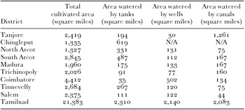
The first is channels from rivers that transported water directly to fields. The Cauvery Delta is home to the canonical system of this kind. As can be seen in Table 2, in the early twentieth century 60 per cent of the canal irrigation in Tamilnad was found there. These systems usually relied upon the damming of a river; the diversion of water from the reservoir was thus created via canals and channels.
Irrigated area in Tamilnad by district and type, circa 1900.

Source: Imperial Gazetteer of India: Provincial Series, Madras, 2 vols (Calcutta, 1946).
The second way in which water is utilized is from wells where water was lifted using either human or animal power. This form of irrigation was expensive. Nevertheless, in the nineteenth and twentieth centuries wells came to irrigate a larger proportion of land. While the data are very rough, it is striking that in the 1820s, wells accounted for 7 per cent of irrigated land in North Arcot. Eighty years later this figure had tripled to 22 per cent. In the same period, tanks declined from watering 71 per cent of the irrigated land in North Arcot to 55 per cent.Footnote 13 Data are not available for other districts in Tamilnad, but the Madras sections of the Imperial Gazetteer, published in 1908, remark on the recent rapid growth in wells, not only in Coimbatore which Christopher Baker has described, but in other areas of Tamilnad as well.Footnote 14 These wells displaced tanks in both the dry and mixed zones, transforming the water cycle as well as the environment of these areas.
The building and maintenance of irrigation works
The establishment of British rule reordered the political economy of irrigation in Tamilnad. While this has been noted by previous scholars, the details of the changes under British governance are hazy and not fully explored in existing works.
In 1777 an unnamed East India Company official conducted ‘Some Enquiries into and Account of the State of the Annacathy [Anicut]’, a lynchpin of the waterworks on the Cauvery River. Dating to at least the early medieval period, and perhaps even earlier, the Grand Anicut, as it was known, lay just beyond the eastern end of the island of Srirangam at the point where the Cauvery and Coleroon reunite. The damming of the river at this point regulated the flow of water into the delta of the Cauvery in Tanjore. In the previous year, when ‘the river came down’, the anicut suffered serious damage, ‘which would have been fatal to the Tanjore Country’, but danger was averted because the breach was ‘instantly repaired by the industry of the people, who with enormous Labor, and at a risk of their lives’ rushed to restore the dam. Since the river was full and thus the water deep, ranging from ten feet near the shores to 16 feet in the middle of the river, five or six boats were hired at Tranquebar in which materials—large ropes, timber, tree roots, grass, sand, and earth—to carry out the repairs were transported.
The official does not reveal who undertook the emergency repairs, but months later, when the author of the above report arrived at the Grand Anicut he found that ‘the Rajah's people [were] employed in repairing the Damage the Bank and Masonry sustained last year’. One of the state officials was a Brahman, who was the ‘head hircar’ (hircara or messenger or courier) of Tanjore and most likely reported directly to the king himself. At the work site there were ‘about 700 Coolies and 200 Bricklayers or Masons, including their assistants and Chunam Beaters’. The hircara entered into contracts with several maistries (head workers) for ‘the performance of certain pieces of work’ and undertook the supervision and payment for these services.Footnote 15 Because the Grand Anicut was the single largest irrigation work in Tamilnad it received the attention of the highest political authorities.
Other large dams, for instance those on the Tambraparni, Vaigai, and Palar, may have drawn the intercession of high-level state officials as well, but the sources that we possess do not reveal this kind of information. Even if not directly engaged in other works of irrigation, rulers and revenue officials were certainly involved indirectly. This is evident from the number of privileged tenures that were granted for undertaking investment in waterworks that were found in the Tamil country.
These privileges varied by locale and by type of investment undertaken. The Dasabandham inam, found in North Arcot and Salem, was very broad and given for the construction, maintenance, and repair of any type of irrigation work, according to B. H. Baden-Powell.Footnote 16 Dasabandham means ten in 100 or a 10 per cent reduction in the revenue. Sundaraja Iyengar adds that Dasabandham tenures were given ‘as compensation for the construction of a tank, well or channel; the grant, generally if not always, carries with it the condition of keeping the work in repair’.Footnote 17 It was not unusual for the permanent nature of the gift (maniyam in Tamil but often better known by the Persian term inam) to be balanced by a permanent obligation to ensure that the waterworks were properly maintained.
Other privileged tenures were for more specific improvements and duties. The anaikarran (anicut man) was charged with preserving anicuts, keeping them in good working order, and ensuring that cattle did not eat the reeds that grew around them. Aulotty was allocated to the individual who mobilized labour for customary work that could be used for the upkeep of irrigation systems. A kalingulamaniyam was granted for the construction of a sluice (calingula) which was an important device for draining off excess water to prevent a tank from bursting and flooding surrounding areas. Similarly, karaimaniyam or kulavettu were awarded to those who gathered workers to repair a tank, and naunal was given for planting reeds for the protection of anicuts and irrigation channels. Potla was granted to tank diggers for the repair of minor damage caused by cattle treading on tanks and channels. Finally, the vaykkal was awarded for preserving channels and other irrigation works. Privileged tenures were also given for services connected to irrigation such as the kulakavval, which was awarded for guarding tanks and ensuring that ryots did not waste water, and the madaivetti for opening and shutting sluices in a tank.
What these forms of privileged tenure show is that even if rulers did not directly finance and supervise irrigation systems, they bore some of the burden of their costs through permanent revenue reductions. While mirasidars, peasants, tank diggers and others ‘on the ground’ undertook the work, they did it in partnership with revenue officials and ruling authorities. These privileged tenures were a form of risk-sharing that was a crucial feature of the pre-colonial order, and which the British forcefully declined to continue when they became the rulers of South India.
South Indian rulers also financed the building and maintenance of irrigation works through taccavi, which was the extension of low or no interest loans for agricultural improvement. The role of the state in improving irrigation appears to have been especially critical for the building and maintenance of tanks, which were often built by individuals with the support of political authorities. Such a role for taccavi reflects a long stream of political thought in South India which praised the king who built a tank.Footnote 18
At the same time, the maintenance of tanks was also undertaken by local communities with local resources. This emerges clearly in Chingleput where in 1799 Lionel Place reported that a portion of the harvest in the villages of the district was set aside for ‘tank marah’ or the upkeep of these storage facilities as well as water channels.Footnote 19 This generally amounted to a small fraction of the total output, but it appears to have been sufficient for the minor repairs that had to be performed every year. Such communal systems of maintenance, which corresponded to communal forms of property rights, were also critical for the maintenance of canals and channels, both in river irrigation and tank systems. They may have had a counterpart in systems of communal labour which provided the workers necessary for the upkeep of these waterworks.
Wells were the final form of irrigation in Tamilnad. These were dug by individuals, but with some support from political and revenue officials. Recall that the Dasabandham tenure, which represented a reduction in revenue of ten per cent, was extended to individuals who constructed a well. Since lifting water was costly, the use of wells was confined to strategic moments when water was critically needed for the success of a crop. For instance, if a tank dried out as crops were ripening, a well could be resorted to in order to save the harvest. Well water was also used for garden cultivation where the high value of the crops made the high cost of lifting water feasible.
Nineteenth-century changes
Under British rule in the nineteenth century the irrigation system of Tamilnad underwent important changes. It was a slow process. Nevertheless, by the end of the century the waterworks of the region looked very different, which had profound consequences for agricultural production, livelihoods, and the environment in the region. These changes stemmed from a combination of factors. The British colonial state focused its resources on big irrigation works such as dams, to the neglect of tanks. The British refused to allow leakages of revenue, which had been an essential risk-sharing role of the state in the pre-British political order. This deprived waterworks not only of funds but also an important institutional framework that had maintained them for centuries. The break-up of communities—most strikingly illustrated by the shift from communal property systems to private ownership of land—also created a novel institutional context which proved to be less supportive of tank irrigation. The rise of private property in land, combined with state credit schemes from the closing years of the nineteenth century, sparked a dramatic expansion in well digging. Wells also became more economically viable as new technologies that were powered by fossil fuels and, later, hydropower reduced the cost of lifting water.
The focus on the ‘big’
The British were well aware that the productivity of agriculture in Tamilnad, as well as their streams of land revenue, depended on the health of waterworks. At the same time, they were restricted in their policies towards irrigation because of budgetary considerations, the limited capacities of the state, and the conception of the state that guided them.
The pre-British rulers of Tamilnad were great bearers of risk. This was a feature of the social order as a whole, and up and down the social, political, and economic hierarchy, those below sought to force those above to bear some of their risk. The colonial transformation heralded, in an important sense, the break-up of this order. In its place, the British introduced into South India a classic Smithian type of state in which political authorities took responsibility for fulfilling essential needs such as the military and providing public goods, which, when it came to agriculture, tended to be large-scale works of irrigation. Even as a Smithian state, the British colonial authorities fell short in a number of ways. Education, in particular, was neglected, but big waterworks did receive support and expanded in the British period.
As we have seen, pre-colonial rulers did not neglect large-scale works such as the Grand Anicut; however, for them this was simply one arena of engagement with irrigation. For the British colonial state in the nineteenth century, by contrast, this comprised almost its entire involvement with the development and maintenance of water control and storage, which were vital for survival in the monsoonal conditions of rainfall in Tamilnad.
This focus on the big is evident from the early nineteenth century when British authorities discovered that the accumulation of sand in the Cauvery was diverting water into the Coleroon and away from the Tanjore Delta. Although sand was removed every year, the level of the Cauvery riverbed was rising, which meant that the capacity of the river, and thus water supplies for irrigation in Tanjore, were decreasing. Under the leadership of Arthur Cotton, the British built the Upper Anicut which dammed the Coleroon and increased the flow of water into the Cauvery itself. According to S. Y. Krishnaswami, ‘To this work, the district of Tanjore largely owes its present prosperity.’Footnote 20 Cotton was also responsible for constructing the Lower Coleroon system, which supplied water to the Chidambaram area of South Arcot as well as portions of the northeastern Tanjore district.Footnote 21 (Outside Tamilnad Cotton designed the systems that created vast tracts of irrigated land in the Godavari and Krishna deltas.)
Later in the nineteenth century, the British undertook the ambitious Periyar works which diverted some of the waters of the Periyar River away from the Arabian Sea via a tunnel which fed the Vaigai. The British also constructed a number of other dams on other rivers in Tamilnad, including the Tambraparni, Ponnair, and Vellar, which increased the area under irrigation from river canals and channels. None of these rivalled the scale of the works on the Cauvery and Coleroon, however, which were the centre of large-scale irrigation in Tamilnad before, during, and after British rule.
These riverine works absorbed the bulk of the public works budget and the administrative capacity for irrigation in the nineteenth century—and even into the twentieth. As a consequence the extensive tank irrigation system was neglected. And given the vast numbers of tanks, their maintenance was not amenable to the same administrative system that was established for large-scale riverine works.
The fate of the tanks
The use of tanks for storing water for irrigation is at least 2,000 years old in Tamilnad. By the nineteenth century the countryside was dotted with thousands of these structures, but the precise state of repair of each of them is difficult to ascertain from the existing sources. Tanks were breached, fell into disrepair, and, it appears, were at times only restored after a time lag. An incident from the late eighteenth century in Madurantakam, a town in Chingleput which contained a substantial tank, suggests this. A group of parayars (Dalit labourers) who had left the area, returned to reclaim their rights of property and cultivation after the tank had been repaired. This is an indication of the fluidity in the irrigation works which mirrored the fluidity of the agrarian order.Footnote 22 The latter, as David Washbrook and others have noted, followed from the mobility of the population.
The tank at Madurantakam was valuable because it watered a substantial area, which made it worth restoring. However, smaller tanks may have burst and cultivators, having lost their source of livelihood, may have migrated and never returned, leaving, by the early nineteenth century, a countryside dotted with tanks in a permanent state of disrepair. Nevertheless, maps from an early survey of India suggest that a substantial number of tanks were operating in Tamilnad in the 1820s. Map 3 of South Arcot and Map 4 of Chingleput, for instance, reveal a landscape in which tanks full of water are the most striking feature.
Over the course of the nineteenth century the tank system went into slow decline, which continued in the twentieth century. This was by no means a precipitous event, but rather a steady and gradual shift from tanks to other forms of irrigation, most importantly, wells. This shift left a significant mark on the environment of Tamilnad. The decrease of water on the surface of the land had profound implications, ranging from diminished biodiversity, to reduced protein supplies for rural populations and lower rates of regeneration of underground water tables. Below the surface, the increase in the number of wells, especially after they were combined with fossil fuel-powered pumps, meant that underground stores of water began to be exploited at a steadily growing rate, which in the twentieth century came to exceed that at which they were replenished.
Arun Bandopadhyay has shown that in the first half of the nineteenth century in several parts of Tamilnad the number of tanks decreased.Footnote 23 Tank numbers were stable in Chingleput; they increased slightly in South Arcot, Coimbatore, Salem, and the Dindigul division of Madura, but North Arcot and Madura experienced a dramatic drop in tanks. The decline was 6 per cent in the former and in the latter nearly 23 per cent. In the same period, the number of wells in North Arcot more than doubled and in Madura grew by 80 per cent. These numbers are obviously very rough, but North Arcot and Madura were in the vanguard of a shift that took off later in the century.
The fate of tanks from the mid-nineteenth century on is difficult to gauge on the basis of quantitative information, but the qualitative evidence for several parts of Tamilnad indicates a decline. In Tinnevelly, David Ludden concludes: ‘The investment climate did not favor farmers who depended on small tanks outside the wet zone . . . Government patronage for irrigation was meager. In addition, many of the locally rich landowners . . . were less capable than before of making investments.’ ‘Zamindars, mirasidar assemblies, temples, and revenue contractors’, who had provided substantial sums of capital for waterworks before 1800, found themselves in a similar position.Footnote 24 David Mosse tells a similar story for Ramnad where ‘estate surveys and detailed reports on the state of tank irrigation at the end of the [nineteenth] century repeat and amplify the descriptions of decay, collapse and vulnerability to flood damage . . . Between 1813 and 1889 the Vaigai river floodwater caused serious damage to systems of tanks weakened by neglect in at least eight seasons.’Footnote 25
The bureaucracy that the British created for overseeing irrigation may have been efficient for constructing and maintaining large riverine works, but was cumbersome when it came to the enormous tank network. After his extensive tour of South India, John Augustus Voelcker reported that cultivators wanted to bring tanks under the superintendence of the Collector of revenue rather than the department of public works. The cultivators complained that ‘when the Tahsildar hears of [the need for repairs on a tank] he goes to the divisional office (Assistant Collector); the latter to the Collector; the Collector to the Executive Engineer of the Public Works Department; the Executive Engineer writes to the Superintending Engineer (stationed in this case, at Trichinopoly, there being only one such officer for three districts); he writes to the chief office at Madras, and says whether it is a matter of first or second importance, and so on’.Footnote 26 Because of the complex chain of command and delays in repair work, it was not uncommon for the season to be a failure before the bureaucratic machinery went into action. ‘Altogether it is a long business,’ Voelcker wrote, ‘and in the end the year's crop is generally lost.’Footnote 27
The maintenance of tanks also went into decline due to the British colonial state's failure to partner with local communities to reduce risk. These included measures such as taccavi (advances for agricultural investment) and the leakage of revenue through inams to support investment in irrigation works. It is likely that the British resumption of privileged and tax-free holdings of land, which happened on a large scale after the inam commission of the 1860s, reduced the funds that were available for the upkeep of tanks. And the failure of the British to distribute taccavi in the same amounts as pre-colonial rulers diminished the investment fund.
Finally, the community institutions that both controlled property and maintained tanks were less effective as a consequence of the privatization of land under the ryotwari settlement. The weakened communities had less power and fewer resources, which made them less capable of implementing improvements in tanks. It was not tanks but wells that were a better fit with individual ownership of land and individual decision-making in agriculture. It is therefore not surprising that tanks began to give way to wells in the nineteenth century, a process which picked up speed in the twentieth century, especially after Indian independence.
The rise of wells
In the early twentieth century there were 32,650 wells in Chingleput district.Footnote 28 By way of comparison, the district had recorded 6,280 wells in the late 1840s.Footnote 29 Two developments pushed forward well digging in Chingleput and elsewhere in nineteenth-century Tamilnad. The first was the devastating famine of 1876–8 in South India. In its aftermath, British officials were persuaded that wells were the only secure source of water for irrigation. The second was the decline in the costs of lifting water as a result of the invention and diffusion of mechanical pumping devices.
The famine of 1876–8 was the most devastating of the nineteenth century in South India and it lay waste to several parts of Tamilnad. British officials interpreted the famine as a consequence of severe drought, which led to the failure of river and tank irrigation systems, and concluded that only water in wells could be relied upon at such times. One of the government's leading agricultural experts, Charles Benson, who was the assistant superintendent of the government farms in Madras, wrote: ‘Wells are of enormous value to the country. They are an insurance against drought, as by their means when the rains fail or are deficient food for both man and beast can be raised.’Footnote 30
Two decades later, H.E. Clerk, the Collector of North Arcot echoed Benson: ‘Real protection from the effects of drought should be sought for mainly under wells . . . The only people that we see pulling through a bad season with the minimum of difficulty are the owners of “well” protected lands. The green and thriving patches of cultivation which gladden the eye in the district in the course of inspection even in the worst of seasons are only due to well irrigation . . . [The] number [of wells is] steadily increasing since fasli 1301 [1891], which was the first seriously bad season after the great famine [of 1876–8] that knocked it into the ryots’ head that he must needs bestir himself to protect himself against the evil day.’Footnote 31
In his post-famine tour of Trichinopoly, Benson noted that the number of wells was limited because ‘well-sinking is an extremely bad speculation’. He also reported that ‘the risks . . . are also great, for a man may, after expending a considerable sum in excavating, find that he has come upon an impervious waterless strata’.Footnote 32 Nevertheless, over the next several decades the number of wells increased rapidly in Tamilnad. Clerk's 1902 study on irrigation reported that some 14,500 wells had recently been dug in the Tamil districts of the Madras Presidency.Footnote 33 This expansion of wells accelerated in the twentieth century. Between 1891 and 1951, according to Christopher Baker, acreage under well irrigation increased by nearly 50 per cent in Coimbatore district and 80 per cent in the Salem district.Footnote 34
Several factors pushed forward the digging of wells in addition to the Madras government's support for them as bulwarks against famine. Charles Benson, writing in 1879, held out hope that the recent Land Improvement Act, which provided government funds for agricultural improvement, would induce ryots to sink wells.Footnote 35 Contemporaries disagreed on the contribution that government credit schemes made to the expansion in wells, however.
In 1888, a special committee appointed to investigate the state of agriculture in the Madras Presidency expressed concern that cultivators had made little use of the Act, which had been designed to reduce the chances of famine, for the sinking of wells.Footnote 36 Twenty years later the situation appears to have changed, and in 1908 the Imperial Gazetteer of India wrote, ‘In one direction there are signs of improvement, and that is in the number of wells which have recently been dug or repaired. In the sixteen years ending with 1904 more than 5½ lakhs was borrowed by the ryots under the Land Improvement Loans Act for this purpose.’Footnote 37
Christopher Baker credits the expansion of markets for high value crops for the expanded digging of wells, which he writes ‘were used to irrigate small “gardens” of extremely intensive cultivation’.Footnote 38 Other accounts report that wells were used in the cultivation of a range of crops. Charles Benson, for example, reported in 1879 that in Trichinopoly ‘the chief crops grown with water raised by machinery are raggy (Eleusine corocana), tobacco, cholum (Sorghum vulgare), cumboo (Pencillaria spicata) and vegetables, paddy being also grown to a considerable extent’. Benson also reported that the rice irrigated from well water was preferred to that grown under the river water irrigation system of the Cauvery Delta and ‘higher class natives prefer this paddy as having some flavor’.Footnote 39
Technological changes which reduced the costs of lifting water further contributed to the expansion of wells. In the 1880s, the Madras government tried to induce ryots to replace the country mhote with the more efficient double mhote, but with little success. Even the wealthier cultivators had no interest in the new device.Footnote 40 These attitudes changed, in part due to the efforts of individuals such as Alfred Chatterton, who was dispatched to Madras as a professor of engineering. Chatterton is well known for his work on the fly shuttle, but he also devoted considerable time and energy to improving water lift technologies.Footnote 41
Until the end of the nineteenth century the lifting of water from wells still relied upon picottahs or mhotes, which used human and animal power respectively, but the coming of oil-driven pumps augured a different future. In the early twentieth century the Imperial Gazetteer of India reported that ‘the farm-school at Melrosapuram . . . has conducted valuable experiments on the capabilities of wells equipped with pumping machinery, which ought to do much to extend this form of irrigation . . . The ryots of the District have taken much interest in these experiments; and Government has sanctioned the establishment in other places of five schools similar to that at Melrosapuram.’Footnote 42
These fossil fuel-powered lift devices diffused slowly, but they marked a shift from organic to mineral energy, to draw upon the distinction Anthony Wrigley has put forward.Footnote 43 In the twentieth century, electrical motors and diesel pumps were added to the list of devices that were available for lifting water, and as the cost of these technologies fell, the utilization of well water has grown by leaps and bounds from the mid-twentieth century onwards.
Conclusion
While retaining the focus on water, this article has moved beyond the wet-dry distinction which has dominated the study of agriculture in Tamilnad. Departing from the availability of water, it has focused on forms of water control, with an emphasis on the tank as a vast system of water storage. Tanks were the backbone of rice cultivation in the river valleys outside the delta of the Cauvery River, such as along the Palar and Tambraparni rivers. They shaped the mixed zones, which were found in many parts of Tamilnad, and they were essential for economic security in low and variable rainfall areas.
By giving a central place to tanks, agrarian and environmental changes in the nineteenth and twentieth centuries may be seen in new light. First, the hydrological context for agricultural activity was not fixed but changed significantly in the last two centuries as tanks gave way to wells. Second, this change in water use and exploitation had profound consequences for both the environment and agricultural production in Tamilnad.
The decline of tanks transformed the landscape of Tamilnad. As already noted, in the late 1760s, 13 per cent of the land in Chingleput was occupied by tanks. A visitor to Madura in the 1870s reported that the area was so covered with tanks that ‘there seems to be more water than land’.Footnote 44 Many of these tanks were small ones that relied on the rains to fill them and were likely to have contained water for only a few months to perhaps half the year, but in both Chingleput and Madura, as well as elsewhere in Tamilnad, there were many substantial tanks that contained water all year round, especially after a good monsoon.
Such a watery landscape would have translated into extraordinary biodiversity. The abundant supplies of water attracted birds from far and wide, including winter migrants from northern zones after the rains of the northeast monsoon in November and December. The Vedanthangal Bird Sanctuary, which lies 60 miles south of Chennai, is a reminder of the rich birdlife that made their homes in the tanks of Tamilnad. The body of water that is the heart of the sanctuary was originally built as a tank. Tanks were also full of fish and would have been home to a range of insects, frogs, and other amphibians. The birds and fish would have also been an important source of protein for the rural population of Tamilnad. When wells replaced tanks, the biodiversity of the region declined.
The decline of tanks and the rise of wells made the agrarian production system less sustainable. While tanks relied upon a renewable resource—the annual rains of the monsoon—wells drew upon underground supplies of water that had amassed over many thousands, if not millions, of years. These supplies can be exhausted, a growing danger in Tamilnad today. In some areas the sinking of new wells has been banned and the state government is struggling with a looming water crisis.
The growing use of well water increased the demand for fertilizers. The silt in river water was an important source of nutrients needed to replenish the soil. Water from tanks contained less silt, but this deficiency was partly remedied by applying the silt deposits in tank beds, which were removed periodically, onto fields. Well water contained no silt. Nor did it yield rich deposits of fertile matter. The shift to well irrigation was accompanied by growing demand for fertilizers. It is therefore not surprising that in the 1930s Madras accounted for half of the artificial fertilizer consumed in India.
Big dams have dominated the environmental history of water in India. Wells are no less important, however.Footnote 45 As this article has shown, the shift to wells began in the nineteenth century and was the result of a lack of investment in the vast network of tanks, which utilized water sustainably for over a millennium; the British colonial conclusion that wells were the only secure form of irrigation in a monsoonal climate; and the invention of lift technologies which relied upon mineral sources of energy, as well as electricity generated by hydropower in the Mettur dam system. While the consequences of these choices became apparent in the twenty-first century, their seeds were sown in the nineteenth.