Introduction
Loess, as a type of eolian sediment, is widely distributed around the world. It is particularly common in the arid and semi-arid regions of the mid-latitudes of the Northern Hemisphere, including Europe, North America, Siberia, Central Asia, and China, among other places. Additionally, there are loess deposits in South America and New Zealand in the Southern Hemisphere (Moska et al., Reference Moska, Adamiec and Jary2012; Wei et al., Reference Wei, Wang, Azarmdel, Khormali, Frechen, Li and Chen2021). As an important geological record, loess reflects local climate change and records information on wind–sand activities, vegetation succession, and human activities, among others. Especially during the Quaternary, the deposition of loess has provided valuable material for studying climate fluctuations (Wu et al., Reference Wu, Qiu, Fu, Rao and Zhu2018).
In China, the thick loess deposits in the Loess Plateau region have formed unique geomorphic features and recorded the climate changes and environmental evolution history over the past few million years (Wenbo and Zhenmin, Reference Wenbo and Zhenmin2003). At the same time, loess sequences in the northern coastal areas of China, which are located in the downwind of the dust transportation path, mainly are distributed along the Bohai Sea coast and Miaodao Archipelago area (Li et al., Reference Li, Cheng and Lu1992; Li and Zhou, Reference Li and Zhou1993; Xu and Wang, Reference Xu and Wang2011). Although the multiple interbeds within the loess sequences of these coastal areas are similar to the inland loess in terms of color and properties, coastal loess records significantly different chronological information compared to the inland loess due to their special material source and abundant marine fossils (Zhao, Reference Zhao1996). For example, the abundance and frequency of foraminifera fossils in coastal loess along the Bohai Sea coast indicate that the dust storms during the last glacial period not only were carried by the northwest and northeast monsoons of the Bohai Sea, but also influenced by the southeast monsoons of the southern Yellow Sea and the East China Sea, highlighting the unique value of coastal loess in revealing the evolution of regional wind fields (Li et al., Reference Li, Wang, Zhao and Liu2002).
Compared with the Loess Plateau region, coastal areas have fewer preserved loess deposits due to the influence of original terrain and the intensity of modern human activities, which are mostly scattered. Therefore, related research on this topic is relatively limited. Early studies systematically investigated the sedimentary characteristics of loess along the Bohai Sea coast (Jiao et al., Reference Jiao, Wei and Fu1987; Li et al., Reference Li, Cheng and Lu1992), clarifying the uniqueness of the coastal loess source (Lu and Li, Reference Lu and Li1990; Cao et al., Reference Cao, Liu, Shi, Chang, Song, Yuan and Guo1993). However, due to insufficient precision in dating techniques and a lack of reliable chronological data, there remains an inadequate understanding of the loess accumulation chronologic framework.
With the application of optically stimulated luminescence (OSL) dating technology, further understanding has been gained regarding the depositional ages of coastal loess. However, due to the multiple sources of coastal loess and its complex processes of deposition and erosion, certain inversion and underestimation of ages have been observed in some stratigraphic sections (Ding et al., Reference Ding, Cao, Xu, Kong and Miao2016; Zhao et al., Reference Zhao, An, Yu and Xu2017). In addition, discontinuous phenomena exist in local loess stratigraphic sections, which may limit the information recorded at single sites (Zhang et al., Reference Zhang, Yu, Liu, Gao and Li2013).Therefore, more comprehensive regional studies are needed to further understand the spatial distribution and temporal framework of loess deposition along the Bohai Sea coast.
This paper summarizes the published loess stratigraphic records along the Bohai Sea coast, analyzes the spatial distribution characteristics of coastal loess stratigraphy, and establishes the chronological framework of loess deposition along the Bohai Sea coast through systematic stratigraphic lithological and age comparisons among regions, aiming to provide more comprehensive evidence for climatic changes in the eastern coastal areas of China.
Geological setting
The Bohai Sea, located in eastern China, is an inland sea surrounded by land on three sides. It consists of three bays (Liaodong Bay, Bohai Bay, Laizhou Bay), one basin (Central Basin), and one strait (Bohai Strait), connecting to the Yellow Sea only through the narrow Bohai Strait. Figure 1 shows the loess sediment distribution along the Bohai Coast. With an area of approximately 77,000 km2, the Bohai Sea has an average depth of about 18 meters and a maximum depth of 85 meters. About 95% of its total area has a depth of less than 30 meters, making it a shallow sea. The seabed is flat and mostly consists of sand and soft mud. The terrain slopes downward from the three bays toward the Bohai Strait, making it sensitive to changes in sea level (Chen, Reference Chen1998; Yi et al., Reference Yi, Deng, Tian, Xu, Jiang, Qiang and Qin2016). The wind field of the Bohai Sea exhibits typical monsoon characteristics. In winter, affected by the Asian continental high-pressure system and the Aleutian low-pressure system, northerly winds prevail. In summer, stable southeast winds dominate. Spring and autumn are transitional periods with frequent cyclonic fluctuations, during which the wind direction is relatively chaotic (Lü et al., Reference Lü, Yuan, Ma and Tao2014; Zhang et al., Reference Zhang, Wang and Ma2025). This shelf-type, shallow-sea nature and monsoon characteristic provide key geological evidence for studying the climate and environmental evolution in the Bohai Sea area.
Loess stratigraphy along the Bohai Coast. (a) Distribution of loess and location of study sites. (b) Study sites on the Liaodong Peninsula. (c) Study sites in the Miaodao Archipelago. (d) Study sites on the Shandong Peninsula.

Geologically, the Bohai Sea area is located in the eastern part of the North China Plate, and its tectonic pattern is mainly composed of three first-order tectonic units: the Bohai Bay Depression, the Jiaoliao Uplift Belt, and the Yanshan Fold Belt (Allen et al., Reference Allen, Macdonald, Xun, Vincent and Brouet-Menzies1997). Among them, the western part of the Bohai Sea is mainly part of the Bohai Bay Depression, which is dominated by Cenozoic sedimentation and characterized by tectonic activity of rifts and subsidence. The southeastern part of the Bohai Sea belongs to the Jiaoliao Uplift Belt, dominated by Paleozoic and Mesozoic basement rocks, and its tectonic activity is characterized by uplift and erosion. The northern part of the Bohai Sea is located in the Yanshan Fold Belt, marked by intense folding and faulting activities during the Mesozoic era (Hu et al., Reference Hu, O’Sullivan, Raza and Kohn2001; Huang and Liu, Reference Huang and Liu2014; Shi et al., Reference Shi, Yao, Liu, Zarrasoañ, Bai, Liu and Liu2016). This tectonic zoning reflects the complex geological evolutionary history of the Bohai Sea area and controls the formation of regional sedimentary patterns and geomorphic features. Figure 1 shows the loess sampling points along the Bohai Coast.
Data
This paper retrieves and collates relevant articles on the loess strata along the Bohai Sea and has statistically compiled 62 loess stratigraphic records (Fig. 1). The statistical scope does not include the hilly areas in front of the mountains in the Shandong Peninsula. Using ArcGIS technology, terrain factors such as altitude, slope gradient, and slope aspect of these loess stratigraphic points were extracted to analyze the terrain characteristics of loess deposition (Supplementary Table 1). Furthermore, 25 of these loess stratigraphic records with higher resolution and clear dating methods and age data were selected for focused research (Fig. 2).
Loess stratigraphic profiles along the Bohai Sea coast.

As a typical aeolian sediment, loess undergoes prolonged sunlight exposure during transport, enabling effective bleaching of mineral grains. Meanwhile, loess deposits are characterized by low organic content and stable sedimentary environments, rendering them less susceptible to post-depositional disturbances. This ensures that the environmental dose rate remains constant (Duller, Reference Duller2004; Madsen and Murray, Reference Madsen and Murray2009). Consequently, OSL dating can yield reliable chronological data for loess sequences.
The dating results of loess at Lingezhuang on the Shandong Peninsula and Tuoji Island in the Miaodao Archipelago showed that within 100 ka, the quartz OSL dating and K-feldspar pIRIR290 dating results exhibited good consistency. However, beyond 100 ka, due to saturation of the quartz signal, the dating error significantly increased, and feldspar demonstrated a longer dating range advantage (Yi et al., Reference Yi, Zeng, Xu, Wang, Wang, Wu and Lu2022). Based on this, for the classic loess sections within 100 ka, this study predominantly adopted quartz OSL dating; while for the older sections, the analysis prioritized the use of feldspar dating data (age data are organized and presented in Table 1).
Loess sections along the Bohai coast and dating range. Due to table size limitations, not all age data are shown; refer to the individual sources cited for full details.

The loess stratigraphic records
By organizing the loess stratigraphic records (Figure 1), it can be found that the loess strata along the Bohai Sea coast are mainly distributed on the west side of the Liaodong Peninsula, north of the Shandong Peninsula, and the Miaodao Archipelago. Loess strata in the Liaodong Peninsula are mainly concentrated in the northwestern part of the peninsula, near the bay areas. Loess strata are distributed around Jinzhou bay, Pulandian bay, Fuzhou bay, and Huludao bay, with an accumulation altitude below 80 meters. On the southeast side of the peninsula, loess deposits are rarely found. So far, early research has only been conducted on the MX profile in Lüshun. Divided by Jinzhou, the direction of loess strata in the northern part of the Liaodong Peninsula is more significant, mostly showing a northwest direction. Although the southern part of the peninsula is also covered with loess, its strata slope direction is not particularly prominent. Taking the DWJ and MXY1 profiles as examples, the main slope direction shows a southwest-by-west direction.
Loess strata records in the coastal areas of the Shandong Peninsula are mainly distributed in the northeastern part of the peninsula, located only 100–300 meters away from the modern coastline. Moreover, these sites are roughly parallel to the coastline, with all accumulations at altitudes below 50 meters. As shown in Supplementary Table 1, the direction of loess strata in the coastal areas of the Shandong Peninsula exhibits spatial differences and has a relatively steep slope. In the Penglai area, the direction of loess strata deposition is mainly northwest, ranging between 286° and 348°; whereas in the Yantai area, the loess strata are predominantly southward, with a slope direction range of 168–202°. Loess strata in the Miaodao Archipelago are widely distributed but scattered, with significant differences in accumulation altitudes. From south to north, the slope gradient of loess deposition increases, and the slope direction of the accumulated strata shifts gradually from southwest to northeast.
Figure 2 shows the stratigraphic profile of loess deposits along the Bohai Sea coast, systematically organized. As can be seen from the figure, the thickest loess accumulation occurs on the Liaodong Peninsula, with thicknesses of 10–25 meters. Along the coastal areas of the Shandong Peninsula, the thickness of loess deposition ranges between 5 and 15 meters. The loess deposits in the Miaodao Archipelago are relatively thinner, with the exception of the BZ profile on Nang Changshan Island, which has a thickness of 16.1 meters; the thickness of the remaining strata is less than 10 meters. Moreover, in the loess stratigraphic sections along the southern coast of the Bohai Sea, including the coastal areas of the Shandong Peninsula and the Miaodao Archipelago, multiple paleosol layers are commonly developed. Three paleosol layers are visible in the LGZ2 profile, ZF profile, and TJD profiles. Although loess accumulations in the YS profile and XJY2 profile are not thick, they also contain paleosol interlayers. Table 1 shows the loess stratigraphic profile and age ranges along the Bohai Sea coast.
Ages of loess stratigraphic strata
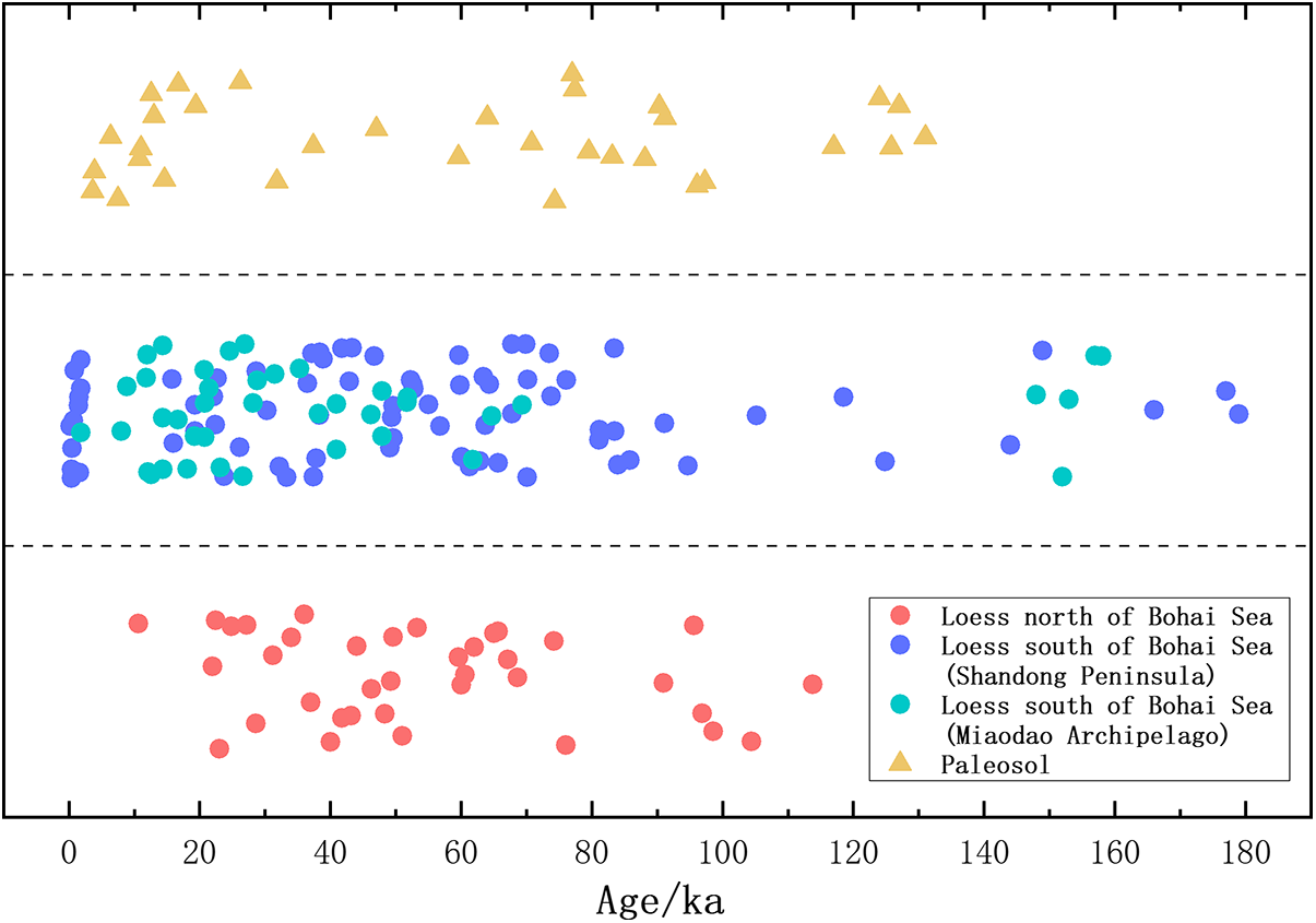
The ages of loess stratigraphic strata along the Bohai Sea coast mainly have been derived from thermoluminescence dating (TL), indirect radiocarbon dating of calcium carbonate nodules, and optically stimulated luminescence (OSL) dating techniques. As shown in Figure 2, the main age range of the loess strata on the Liaodong Peninsula is concentrated between 20 ka and 100 ka. In the study area, only the QDS profile in Dalian has paleosol layers with dating data support. The formation age of this paleosol layer is 125.8 ± 13.8 ka, which is also the oldest age for the loess–paleosol sequence of the Liaodong Peninsula currently under investigation. The ages of the loess strata in the coastal areas of the Shandong Peninsula indicate that the formation periods of the loess strata in the Penglai area are mainly concentrated in two stages: 20–70 ka and 150–170 ka. The age of the loess strata in the Zhifu Island area of Yantai ranges between 63 ka and 125 ka. The age of the loess cliff at the LGZ1 profile in Penglai shows an age of 179 ka, which represents the earliest accumulation period of loess to appear in the coastal areas of the Shandong Peninsula. The ages of the loess in the Miaodao Archipelago are concentrated between 10–50 ka and 148–158 ka, with the earliest accumulation occurring on the TJD3 profile, which dates back to 158 ka.
The development times of paleosols along the Shandong Peninsula coast are scattered, while those in the Miaodao Archipelago are concentrated between 60 ka and 90 ka. The Zhifu Island stratigraphic section has a continuous sequence of loess–paleosol deposits, with paleosol formation ages of 70–83 ka, 95–105 ka, and 120–125 ka.
The chronological ages of the loess strata along the Bohai Sea coast are shown in Figure 3. Loess along the Bohai Sea coast shows continuous and concentrated deposition during the 20–70 ka period, while there are relatively fewer age dates in the 70–120 ka interval. By contrast, loess records are scarce on the Liaodong Peninsula along the northern coast of the Bohai Sea, while continuous loess deposition is still observed along the southern coast of the Bohai Sea, including the coastal areas of the Shandong Peninsula and the Miaodao Archipelago. Moreover, during the150–180 ka, loess accumulation was relatively concentrated. Development of paleosols was concentrated at 4–15 ka, 75–85 ka, 90–100 ka, and 125–130 ka, showing a clear alternation with periods of loess accumulation.
Age distribution of the loess strata. The y-axis enhances data visualization and has no geological significance.

Discussion
Distribution characteristics of loess strata
Liu (Reference Liu2002), divided the loess in China into three major regions from west to east according to the characteristics of loess deposition: the western arid inland basin area, the central Loess Plateau area, and the eastern piedmont hilly plain area. The loess along the Bohai Bay coast is part of the loess in the hilly plain area in the eastern hinterland and is a typical representative of coastal loess in China as well as the eastern boundary of the distribution of the continental loess in China. Previous studies have confirmed that the source of the loess along the Bohai Bay coast is mainly from inland dust in the northwest and shelf dust (Xu et al., Reference Xu, Zhang, Xu, Zhang, Qi and Ji2019; Li et al., Reference Li, Wang, Li, Du, Zhang, Song, Du and Sun2022). Loess along the Bohai Bay coast has significant differences in provenance compared to the loess on the Chinese Loess Plateau, and at the same time, it is influenced by the underlying original terrain. Meanwhile, affected by the underlying original terrain, the spatial distribution of the loess along the Bohai Sea coast also has its uniqueness, accumulating mostly in the piedmont areas of plains and low mountains and hills on the east side of the Bohai Bay. From north to south, it mainly includes the west side of the Liaodong Peninsula, the Miaodao Archipelago, and the coastal area west of Penglai on the Shandong Peninsula, forming a north-south trending loess belt.
The loess deposits in the Liaodong Peninsula exhibit a predominantly northwest slope direction and are mainly preserved in nearshore bay areas. Provenance analysis indicates that the sedimentary material was primarily derived from Liaodong Bay (Yang and Zhang, Reference Yang and Zhang2017). Controlled by the topography with higher central and lower eastern and western flanks of the peninsula, the near-source materials transported by northwest winds predominantly accumulated on the western side (Li et al., Reference Li, Zhang, Li, Yang and Ding2010; Bi et al., Reference Bi, Zhang, Liu, He and Liu2013). Meanwhile, the shallow bays during glacial periods likely provided abundant sediment sources, while the semi-enclosed topography weakened wind action, facilitating the deposition and preservation of aeolian materials (Liu et al., Reference Liu, Feng, Liu and Lin2012).
The slope direction of coastal loess strata in Shandong Peninsula shows regional variation, which also is related to differences in sediment source areas across these regions. In the Penglai area, the loess deposits predominantly exhibit a northwest direction, attributed to their proximal sediment sources primarily being exposed dust from Laizhou Bay. In contrast, the loess deposits in the Yantai region display southwest and southeast directions, with thicknesses less than those in neighboring Penglai, likely due to partial sediment contributions from local bedrock-weathering debris (Niu et al., Reference Niu, Jin, Liu, Zhong and Zhang2010; Lin et al., Reference Lin, Liu, Wu, Liu, Li, Li, Wang, Liu and Chen2021). Loess deposits in the Miaodao Archipelago show a progressive shift in slope direction from southwest to northeast along the south-north transect, controlled by its position as the natural Yellow Sea–Bohai Sea divide. The material sources mainly consist of shelf-derived sediments from Laizhou Bay transported by southwesterly winds and northern Yellow Sea shelf particles carried by northeasterly winds. Figure 4 shows the slope gradient and direction of the loess strata (Zhao, Reference Zhao1996; Xu et al., Reference Xu, Ding, Yu and Ni2015; Cao et al., Reference Cao, Wang, Chen, Xu, Zhang, Wu and Wang2023; Zhang et al., Reference Zhang, Wang, Song, Liu, Xia, Risha and Qiu2024).
Slope gradients and directions of the loess strata.

The thickness and elevation of loess deposits along the Bohai Sea coast also show regional variations. On the Liaodong Peninsula, loess deposits range from 10 m to 25 m in thickness with depositional elevations below 70 m, while in coastal areas of the Shandong Peninsula, thicknesses vary between 5 m and 15 m with elevations under 50 m. These differences may relate to underlying topographic slope gradient, regional location, and sedimentation rates. The slope gradient of the loess-accumulation area in the Liaodong Peninsula ranges between 3.6° and 9.04°, while that in the Shandong Peninsula loess-accumulation area is steeper than in Liaodong, ranging from 4.7° to 19.74°. Moreover, the Liaodong Peninsula is at a higher latitude and spatially closer to the northwestern sediment source area, whereas the Shandong Peninsula is downwind, resulting in thinner loess accumulation. As shown in Figure 4, during the period of 20–46 ka, the deposition thickness of the MCY section on the Liaodong Peninsula was significantly greater than that of the XZP1 section on the Shandong Peninsula. During the time span of 23–73 ka, the LHC section on the Liaodong Peninsula accumulated a thickness equivalent to that of the LGZ2 section on the Shandong Peninsula in just 30 ka, which formed for 50 ka. The difference in sedimentation rates might be another reason for the thicker loess deposits on the Liaodong Peninsula compared to those along the coast of the Shandong Peninsula.
The loess in the Miaodao Archipelago mainly fills ancient gullies and gentle slopes (Cao et al., Reference Cao, Liu, Shi, Chang, Song, Yuan and Guo1993; Qiu et al., Reference Qiu, Wang, Wang, Chang, Wang, Chen and Sun2024). The loess deposits are relatively thin, with the exception of the BZ section, where the loess accumulation thickness is less than 10 meters in all other sections. This is because this area is highly susceptible to erosion by running water and waves and is relatively far from the modern coastline. Loess could accumulate in this location only when global sea levels were extremely low, exposing the surrounding submarine areas or causing accumulation due to the influence of strong winds during deposition (Chen et al., Reference Chen, Kong, Xu, Lou and Zhang2020; Yi et al., Reference Yi, Zeng, Xu, Wang, Wang, Wu and Lu2022).
Major loess accumulation periods
Figure 5 shows the comparison of loess records with other reconstruction information over the last 200 ka. Rapid loess-accumulation periods on the northern coast of the Bohai Sea occurred around 22–31 ka and 61–68 ka (Figs. 3 and 5a). This stage coincided with the low sea level stages both globally and in the Bohai Sea region (Grant et al., Reference Grant, Rohling, Bronk Ramsey, Cheng, Edwards, Florindo and Heslop2014; T. Wang et al., Reference Wang, Zou, Mao, Zhou and Mo2022). The period of 22–31 ka corresponds to MIS 2, the last glacial maximum, when global sea levels dropped due to the expansion and increased volume of high-latitude ice sheets. It is estimated that sea level in the East China Sea fell by more than 100 m (Cheng et al., Reference Cheng, Ezer and Hamlington2016). Considering that the average depth of the Bohai Sea today is only 18 m, the Bohai Shelf may have been completely exposed during this time, leading to the most active period of loess accumulation (Miao et al., Reference Miao, Chongyi, Xu, Wang, Hanson, Chen and Shi2022). The period of 61–68 ka corresponds to MIS 4, the early phase of the last glacial period, which coincides with the H6 cooling event (63.54–64.41 ka) within the Heinrich events. This period aligns with the maximum glaciation during MIS 4 (64.5 ka) as recorded in the Xinya Cave sediments and the corresponding lowstand in global sea levels (Oster et al., Reference Oster, Montañez, Mertz-Kraus, Sharp, Stock, Spero, Tinsley and Zachos2014; Xue et al., Reference Xue, Wu, Chen, Li, Cheng, Shen, Zhang and Li2025). Climatic conditions during this time were conducive to enhanced wind-related activities and the capture of aeolian dust.
Comparison of loess records with other reconstruction information over the last 200 ka. (a) Loess in the Liaodong Peninsula in the northern Bohai Coast. (b) Loess in the southern Bohai Coast, including the coastal areas of the Shandong Peninsula and the Miaodao Archipelago. (c) Paleosols along the Bohai Coast. (d) Reconstructed relative sea level (L. Yi et al., Reference Yi, Deng, Xu, Yu, Qiang, Jiang and Chen2015; S. Yi et al., Reference Yi, Zeng, Xu, Wang, Wang, Wu and Lu2022). (e) Stalagmite ∂18O record from Sanbao-Hulu caves (Wang et al., Reference Wang, Cheng, Edwards, Kong, Shao, Chen, Wu, Jiang, Wang and An2008; Cheng et al., Reference Cheng, Edwards, Broecker, Denton, Kong, Wang, Zhang and Wang2009). (f) Ideal loess–paleosol sequence in the northern Bohai Sea. (g) Ideal loess–paleosol sequence in the southern Bohai Sea.

The southern coast of the Bohai Sea experienced continuous loess deposition during 18–70 ka (Fig. 5b), with a longer period of concentrated accumulation compared to the northern coast, which may be attributed to the influence of the Yellow River’s sediment transport volume and pathways. During the Early Pleistocene, the Yellow River had already begun to influence the sedimentary pattern of the Bohai Sea. Since 0.71 Ma, the sediment transport volume of the Yellow River has shown a significant increasing trend (Zhang et al., Reference Zhang, Yue, Liu, Chen, Zhang and An2023). During the Late Pleistocene, the Yellow River gradually developed into a modern river system that connected its upper and lower reaches.
The Yellow River Delta is located at the junction of the Bohai Bay and Laizhou Bay near the current Dongying City in Shandong Province (Chen et al., Reference Chen, Liu, Lu, Lu, Wang and Li2002; Liu et al., Reference Liu, Saito, Wang, Zhou and Yang2009). From the perspective of sediment transport pathways, the Yellow River’s sediment transport is mainly concentrated near the estuary and in the shallow sea area with a water depth of 20 meters, which is close to Laizhou Bay (X.M. Liu et al., Reference Liu, Qiao, Wan, Zhong, Ma and Liu2019). Subsequently, sediment dispersion primarily follows two transport pathways: one enters the Yellow Sea via the Bohai Strait along Laizhou Bay, and the other moves northeastward into the central Bohai Sea (Fig. 1). During winter, it can extend as far as 38.6°N (Liu et al., Reference Liu, Qiao, Zhong, Wan, Xue and Liu2020), thus having minimal effect on Liaodong Bay.
This spatial distribution pattern is also supported by provenance studies. Drill core analyses from Liaodong Bay indicate that the Yellow River becomes the primary sediment source for this region only under specific water levels and climatic conditions when its main channel shifts northward. During other periods, proximal northern rivers dominate the deposition (Dou et al., Reference Dou, Li, Zhao, Zhao, Wei, Yang, Bai, Zhang, Ding and Wang2014). In contrast, the Nd–Sr isotopic composition and uranium isotope ratios (23⁴U/23⁸U) of Shandong loess closely resemble those of the lower Yellow River sediments, confirming that the extensive fluvial deposits of the North China Plain and the Bohai Bay continental shelf serve as the main sources for the southern coastal loess (Wang et al., Reference Wang, Yang and Ding2021; Zhang et al., Reference Zhang, Yue, Liu, Chen, Zhang and An2023).
In summary, the influence of Yellow River sediment discharge on Laizhou Bay is significantly stronger than that on the Liaodong Bay. Combined with the shallower average water depth of Laizhou Bay, this region was more conducive to the transport of proximal sediments to coastal loess-accumulation areas during the glacial lowstand periods. These combined effects likely constitute the key factors responsible for the prolonged loess deposition observed along the southern Bohai coast.
Results of the multi-point age data (Fig. 3) show that during the period of 100–125 ka, there are relatively fewer age data of loess layers along the Bohai Sea. This may be related to the occurrence of sedimentary hiatuses in some regions during this period. The dating study of the LGZ1 section in Penglai, Shandong Peninsula, provided evidence that there was a significant sedimentary hiatus between the penultimate glacial period loess strata (164.7 ± 8.9 ka) and the overlying paleosol (74.5 ± 5.3 ka) (Tian et al., Reference Tian, Sun, Lü, Cao, Zhang and Lü2019). At approximately 129 ka, global sea level was 5–10 meters higher than present, primarily attributed to melting of glaciers and rising sea-surface temperatures, leading to an increase in global meltwater volume (Simms et al., Reference Simms, Ishiwa, Hodgson, Tamura and DeWitt2024). This high sea level event is also well documented in the North Atlantic (McManus et al., Reference McManus, Bond, Broecker, Johnsen, Labeyrie and Higgins1994). The Bohai Sea, as a typical shallow shelf sea, has 26% of its area within the 10-m depth contour (Yuan et al., Reference Yuan, Bi, Wu, Zhang and Wang2016), making it particularly sensitive to sea level changes. This significant marine transgression not only led to widespread submergence of the continental shelf in the sea area, but also limited the original supply of dust material in the aeolian system. Meanwhile, the substantial rise in sea level may have intensified the hydrodynamic forces along the coast, significantly affecting the preservation of loess during this period and leading to sedimentary hiatuses.
Elevated sea level leads to the flooding of continental shelf source areas, limiting the supply of dust material. This phenomenon demonstrates the controlling influence of sea level changes on coastal sedimentary processes. Driven by precessional forcing, enhanced summer insolation at 65°N modifies the land–sea thermal contrast, intensifying the East Asian southerly monsoon. This atmospheric dynamical response ultimately regulates summer precipitation patterns in northern China (An et al., Reference An, Steven, Shen, Qiang, Jin, Sun and Prell2011; Yi et al., Reference Yi, Yu, Ortiz, Xu, Chen, Ge, Hao, Yao, Shi and Peng2012). Both the coastal loess deposits around the Bohai Sea and the sedimentary systems along the Japanese coast are influenced by the East Asian monsoon regime. A peak in Cryptomeria pollen values in Lake Biwa, Japan, during 112–128 ka indicates warm and humid climatic conditions associated with intensified East Asian summer monsoon activity (Hayashi et al., Reference Hayashi, Takahara, Inouchi, Takemura and Igarashi2017). The resultant increase in precipitation would have suppressed loess accumulation, further supporting the hiatus of sedimentation along the Bohai coast at that time.
The period of 148–175 ka is another major accumulation phase of the loess along the southern coast of the Bohai Sea (Fig. 5a). This period falls within the early stage of the penultimate glacial period, during which global sea level was approximately 40–60 m lower than present (Duhamel et al., Reference Duhamel, Colin, Revel, Siani, Dapoigny, Douville, Wu, Zhao, Liu and Montagna2020; Nehme et al., Reference Nehme, Kluge, Verheyden, Nader, Charalambidou, Weissbach and Gucel2020). However, contemporaneous loess stratigraphic records are absent in the Liaodong Peninsula area north of the Bohai Sea (Fig. 5b). This regional difference may be related to age underestimation caused by the selection of optically stimulated luminescence (OSL) dating materials. Through comparison with standard stratigraphic profiles, the upper limit of quartz OSL dating in the Luochuan loess is restricted. When the equivalent dose exceeds 300 Gy or the age exceeds 70–100 ka, the luminescence signal is likely to reach saturation (Lai and Fan, Reference Lai and Fan2014). Wang et al. (Reference Wang, Huang, Fan and Li2024) further pointed out in their study of the geological chronology of volcanic eruption events that using feldspar as the dating material or adopting the initial OSL signal of baked quartz in lava for dating can yield more reliable results. The loess stratigraphic ages from 148 ka to 175 ka along the southern coast of the Bohai Sea are primarily derived from the LGZ1 profile and the TJD3 profile, where feldspar was used as the luminescence dating material. OSL dating of the loess on the northern Bohai Coast mainly used quartz as the dating material without signal saturation correction, which could potentially lead to a systematic underestimation of the ages and thereby result in the absence of dating records for the loess on the northern coast during this time period.
Paleosol interbeds of the loess strata
Paleosols along the Bohai coast developed intensively during 4–15 ka, 75–85 ka, 90–100 ka, and 125–130 ka (Fig. 5c). During the two older periods, global sea level was in a stable high stage (Fig. 5d). OSL dating of cores from the northern Bohai coast also identified three marine transgression units occurring during MIS 7, MIS 5, and MIS 1 (Li et al., 2019). Affected by rising sea levels, the near-source materials on the Bohai shelf were restricted, leading to interruptions in loess deposition. During this period, stalagmite records show a strong summer monsoon that brought abundant rainfall and heat (Fig. 5e), driving the intensification of pedogenesis (Li and Gao, Reference Li and Gao2019).
Compared to the Liaodong Peninsula, the coastal areas of the Shandong Peninsula and the Miaodao Archipelago not only have a higher frequency of paleosol interlayers, but also larger single-layer thickness (Fig. 2). This difference may be related to local climatic conditions and the material composition of the loess deposits. The quantitative reconstruction of paleoclimate based on pollen data indicates that during 9.91–7.44 ka, the proportion of tree pollen in the coastal area of the Shandong Peninsula was 33.7% (Shang et al., Reference Shang, Li, Wang and Wang2024); the content of tree pollen in the northern Bohai Coast region during 9.6–8.95 ka accounted for 39.95% (You et al., Reference You, Yang, Li, Zhang, Zhang, Ma, Shi, Wang, Zhang and Yang2025). The increase in the proportion of tree pollen reflects colder and drier climate in the northern Bohai Coast, which limited development of paleosol in this region. In addition, the Shandong Peninsula is located at a lower latitude and is more significantly influenced by the summer monsoon, which may have provided more favorable water and temperature conditions for the development of paleosols.
From the perspective of the material composition of the loess strata in the two regions, the grain size of the loess in Shandong Peninsula is finer than that in Liaodong Peninsula during the same period. Around 49 ka, the median grain size of the loess in the Laohucun section of the Liaodong Peninsula was 37 μm (Liu et al., Reference Liu, Yang, Xu, Jia, Zhang, Wei, Chai and Ruifeng2024), while the median grain sizes of the loess in the Zouyu and Linggezhuang sections of the Shandong Peninsula were 28 μm and 26 μm (Tian et al., Reference Tian, Sun, Lü, Cao, Zhang and Lü2019), respectively. The grain-size composition of loess largely determines the structural characteristics of the soil body, which in turn influences its hydrophysical properties (Hou et al., Reference Hou, Liu, Li and Chi2005; Y.F. Liu et al., Reference Liu, Zheng, Yang, Zhu and Sun2019). The finer-grained loess has smaller pores, therefore it has a slower water-loss rate and stronger water-retention capacity, which can provide better conditions for soil formation (Fan, Reference Fan2019; Zeng, Reference Zeng2023).
Based on a comprehensive study of stratigraphic records and dating data from the region, this paper has constructed a loess–paleosol sequence framework for different areas along the Bohai Sea (Fig. 5). Based on the current stratigraphic records and age data analysis, it can be seen that paleosols in the northern Bohai Coast developed around 125 ka, and the rapid loess accumulation occurred during two periods: 22–31 ka and 61–68 ka. By comparison, loess deposition in the southern Bohai Coast began at approximately 175 ka, with rapid accumulation occurring around 150 ka. Paleosols were concentrated in several stages in the southern area: 125–130 ka, 90–100 ka, and 75–85 ka. From 18 ka to 70 ka, continuous rapid loess accumulation occurred in the southern area, followed by development of paleosols during the 4–15 ka period.
Conclusions
This paper reviews the publicly published articles on loess strata along the Bohai Sea, organizing and analyzing the existing loess stratigraphic records and dating data, and mainly draws three main conclusions. First, the loess accumulation thickness in the Liaodong Peninsula is 10–25 meters, mainly distributed on the northwest-facing slopes and concentrated in the areas near the bay. Along the coastal area of the Shandong Peninsula, the loess thickness is 5–15 meters, with regional differences in orientation. In the Penglai area, the loess predominantly faces northwest, while in Yantai, it shows a southward orientation. For the Miaodao Archipelago, except for the BZ profile, the loess thickness in all other profiles is less than 10 meters. The loess orientation transitions from southwest to northeast as it moves from south to north, and its thickness is related to the slope of the underlying terrain, regional location, and sedimentation rate. The variation in orientation is mainly limited by the differences in the nearby source areas, which is significantly constrained by topography.
Second, statistical analysis of existing chronological data reveals that loess deposition along the Bohai coast exhibits both synchrony and regional variability. Two periods of rapid loess deposition occurred at 22–31 ka and 61–68 ka, while the Shandong Peninsula coastal area and Miaodao Archipelago show prolonged deposition (18–70 ka) due to Yellow River sediment input. Around 150 ka, regional differentiation emerged: loess in the Shandong Peninsula coastal area and the Miaodao Archipelago rapidly accumulated during 148–175 ka. In contrast, the ages of the loess on the Liaodong Peninsula may have been underestimated due to the use of quartz materials for OSL dating without signal saturation correction, leading to a potential gap in the loess age record prior to 125 ka.
Third, the development of paleosols along the Bohai Coast also exhibits phased characteristics, concentrated during 4–15 ka, 75–85 ka, 90–100 ka, and 125–130 ka. Compared with the Liaodong Peninsula, both the frequency of paleosol interlayers and the thickness of individual layers are more pronounced in the coastal areas of the Shandong Peninsula and the Miaodao Archipelago. This spatial difference may be related to climatic conditions and differences in the grain size of the loess.
Acknowledgments
This work was supported by the National Natural Science Foundation of China, grant number 41601190, and the Basic Research Project of Colleges and Universities of Liaoning Provincial Department of Education (Natural Science Category), grant number LJKMZ20221413.
Data availability
Data will be made available on request.
Declaration of competing interest
The authors declare that they have no known competing financial interests or personal relationships that could have appeared to influence the work reported in this paper.
Author contributions
Jia, F.F. and Sun, Y.H. conceived the paper. Sun, Y.H. finished the original draft preparation. Jia, F.F., Sun, Y.H., and Liu, L. confirmed the reliability of the data and edited and reviewed this manuscript.