Introduction
The al-Jumayil site
The archaeological site of al-Jumayil (MEGA Jordan 2728) is located on the southern edge of the fertile Moabite plateau, approximately 35 km southwest of Madaba and about 3.5 km west of the UNESCO World Heritage site of Umm ar-Rasas (Kastron Mefaa) (Figure 1). The name of the site during the Byzantine period remains unknown, even though some scholars have proposed identifying al-Jumayil with the biblical town of Beth Gamul—mentioned in Jeremiah 48:23 alongside other ten towns on the Moabite plateau such as Dhiban and Mefaa (Benedettucci Reference Benedettucci2017, 9–17; Glueck Reference Glueck1933, 36–37).
Location map of al-Jumayil and other sites mentioned in the text.

Al-Jumayil saw significant growth during the Byzantine period (Chang-Ho and Attiyat Reference Chang-Ho, Attiyat and Kehrberg1997), where it formed part of the province of Arabia and fell within the ecclesiastical jurisdiction of the Bishop of Madaba (Piccirillo Reference Piccirillo2005, 378–382).
The ongoing research by the Department of Classical Archaeology at the University of Vienna in al-Jumayil has so far focused on the double-church area (Hamarneh et al. Reference Hamarneh, Löffler-Leutgeb, Leutgeb, Golian, Habrich, Hansen, Male, Schraml, Zischkin and Eder2022b; Hamarneh et al. Reference Hamarneh2023, forthcoming). The construction date of the double church, which lacks inscriptions, has been determined to be during the second half of the 6th century CE based on the stratigraphic excavation results, its similarity to other dated churches and stylistic comparisons with dated mosaic floors (see below). This research however aims to enhance the understanding of the church complex by focusing on its chronological development. The methodology primarily involves radiocarbon dating of organic inclusions identified within the mortar used to fill joints between stones and coat the walls, alongside an analysis of the mortar’s production technology (for similar methodology in Jordan see for example: Al-Bashaireh (Reference Al-Bashaireh2013) and Al-Bashaireh and Lindauer (Reference Al-Bashaireh and Lindauer2023). Furthermore, data from previous archaeological excavations and historical records were incorporated to support the radiocarbon dating results and address gaps in the chronological framework.
The Church Complex
Description and Architecture
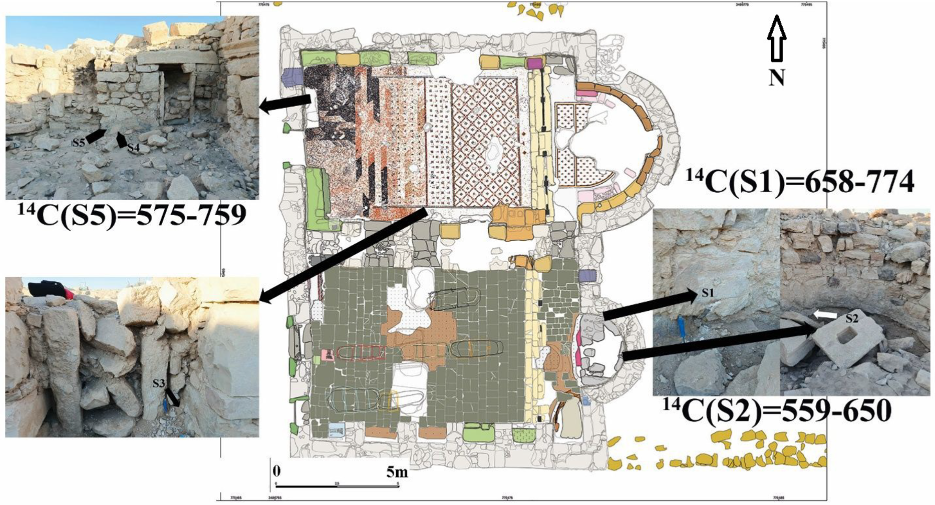
The ecclesiastical complex is situated on the western edge of the site, within a larger rectangular enclosure. It has an axial west-east orientation and covers approximately 258 m2. It consists of two adjacent single-nave churches, each with its own apse, as well as a square structure with multiple rooms located to the north (Figure 2). Initially, Savignac (Reference Savignac1936, 242) recognized the southern church when he visited the site in 1932, and later Piccirillo (Reference Piccirillo1989, 260–261) made reference to it. Excavations conducted in 2021 led to the discovery of a second, previously unknown church to the north, which had been completely concealed beneath collapsed arches and thick layers of debris. The recent archaeological evidence regarding the construction of the two churches indicates that the South Church was erected shortly after the North Church. The complex was affected by a series of destructive earthquakes that struck the region; the known 749 CE and 1068 CE earthquake (among others) are plausible causes for the church’s collapse and subsequent abandonment.
Locations and calibrated radiocarbon dates of the investigated samples from the Double Church.

The upper layers predominantly yielded pottery from the Mamluk period, whereas strata associated with the building’s abandonment contained sherds dating to the Fatimid, Abbasid, Umayyad, and Byzantine periods. Lastly, nearly all ceramic fragments recovered from the building’s construction phase can be attributed to the Byzantine period.
The exceptional preservation of architectural elements—such as the walls, the corbels supporting the vault, and the structural system of the hemispherical dome over the presbyterium—along with remnants of the collapsed roof, allows the building to be classified as a fully stone-built structure. While these are well documented in the Hauran region, they are comparatively rare within the Diocese of Madaba, as in the case of Nitl (Hamarneh Reference Hamarneh2006). Furthermore, the church incorporates a significant quantity of spolia, likely repurposed from earlier structures. Its walls were originally plastered, and the floor was adorned with mosaics. To the east, two apses slightly differing in size, that of the North Church being the largest, conclude the building. The northern outer wall of the church is shared with an unspecified building complex. Internally, the church complex consists of two adjoining naves of the same size, 7.9 m wide and 11.2 m long, separated by five rows of double pillars. The respective opposing faces of the northern and southern walls likewise show five rows of pillars.
The removal of the collapsed arches and roof slabs of the North Church revealed the Bema, raised by two steps and surrounded by a chancel screen. The lower edge of the broken black oil-shale chancel screen and posts were found in-situ, fixed into the sockets and railing grooves using lime mortar. Chancel screen fragments were also found in the surrounding layers. The steps, between the nave and presbyterium, were arranged to indicate the entrance by means of rectangular recess cuts.
Parts of the North Church are still paved with mosaic floors of different patterns, including large squares touched through rosebuds with their long stems arranged in the shape of a cross, diagonally arranged rosettes and lozenges flanking a chalice-shaped floret, and stripes of black and red color with few florets, surrounded by scrambled tesserae, none however revealing any trace of the former decoration (Figure 2). The closest parallel of the lozenges’ design, often encountered in the mosaics of the region, comes from the Bishop Sergius church, the Lion’s Church, and the North Church (or church of the Rivers) in Umm er-Rasas, all dated to the end of the 6th century (Piccirillo Reference Piccirillo1993; Bujard Reference Bujard2016).
The South Church of al-Jumayil also had its Bema raised by two steps and surrounded by a chancel screen formed of oil-shale, with conserved remains uncovered in the sockets and railing grooves. A large looting hole has completely removed the floor of this area, while the remains of mosaics were found in the north-west corner, featuring a double-stranded guilloche pattern that originally formed the outer frame. The decorations showed a cross in a circle, with lilies between the outer arms. Such patterns appear on chancel barriers and capitals found in the Lion’s church, the south church (church of the Palm tree) inside the Castrum of Umm er-Rasas, and in the church next to the so-called Stylite Tower also at Umm er-Rasas (Piccirillo Reference Piccirillo1989; Acconci Reference Acconci, Piccirillo and Alliata1994). However, the excavations revealed that flat and rectangular stone slabs replaced the mosaic floor of the South Church, presumably in the second half of the 8th century CE.
Comparable structures and architectural elements
Overall, the al-Jumayil complex is compelling on both architectural and liturgical grounds. While ecclesiastical complexes frequently comprise multiple churches or chapels, instances of twin churches are also attested in Provincia Arabia. These typically exhibit comparable architectural characteristics—most often basilical or single-nave layouts—such as those found in the twin churches within the Castrum at Umm er-Rasas, the adjacent churches at Nitl (the closest parallel, see Hamarneh Reference Hamarneh2006), as well as the Double Church at Umm el-Jimal (Butler Reference Butler1913; De Vries Reference De Vries1993, Reference De Vries2000). In several of these examples, the churches were not built simultaneously, likely due to differing dedications and functions—whether liturgical, commemorative, or funerary.
The excavations of the al-Jumayil church complex have revealed important findings—such as chancel screen fragments, plaster, tesserae, a basalt millstone, and pottery spanning the Byzantine, Umayyad, Abbasid, and Fatimid periods (roughly end of the 6th century CE to 9th–11th century CE)—that illustrate the building phases and its prolonged occupation and reuse. These insights contribute to understanding Islamic-period settlement patterns, while future research will focus on agricultural practices, material analysis, and regional integration.
The Double Church inside the Castrum of Umm er-Rasas
The two adjacent churches are located inside the Roman military fort of Umm er-Rasas. The northern church is known as the Rivers Church, and the southern church is known as the Palm Tree Church (Piccirillo Reference Piccirillo1993). The Rivers Church, the first to be built, is among the oldest surviving structures in the Castrum, with all adjacent buildings abutting its walls. The interior featured a mosaic floor with a dedicatory inscription dating the work to a 12th indiction, corresponding to either 578/579 or 593/594 CE, and placing its creation in the same year as the mosaic of St. Paul, which is likewise dated to a 12th indiction (Bujard Reference Bujard2016; Piccirillo Reference Piccirillo1997). The rectangular nave, measuring 14.2 by 9.8 m, was divided by two rows of three arcades supported by square pillars carefully set in quadrangular blocks of shell limestone and topped with capitals. Evidence suggests that the church was originally roofed with tiles, as indicated by the wide spacing between the arcades and the large quantity of tegulae fragments uncovered during excavations. Three entrances pierced the western façade: a large central doorway and two narrower side doors providing access to the side aisles. The lintel of the main entrance is decorated with three crosses, while the preserved lintel of the northern secondary entrance bears a cross inscribed within a tabula ansata. Subsequently, a second church, the church of the Palm Tree, was constructed adjoining the southern wall of the Rivers Church with a similar plan and was paved with mosaics (Bujard Reference Bujard2016, 45–48). As evidenced by the obliteration of human and animal motifs on their mosaic floors, both churches were in use during the eighth century (Hamarneh Reference Hamarneh, Hamarneh and Bianchi2021).
The complex of Nitl
The large complex of Nitl (diocesis of Madaba) comprises two large, parallel, single-nave churches, roofed with arches and stone slabs. The churches, the South Church and the North Church, are interconnected by a doorway set in the shared interior wall. Each church is associated with its own service rooms (diakonikon), constructed externally along the southern and northern exterior walls of the complex, respectively (Piccirillo Reference Piccirillo2001). The North Church is a single-nave structure with a roof supported by nine arches and covered with stone slabs (Hamarneh Reference Hamarneh2006, Reference Hamarneh, Hamarneh and Bianchi2021; Piccirillo Reference Piccirillo2001). Originally, two entrances were located on the western façade; however, the northern doorway was subsequently blocked, leaving only the central entrance functional. A modern dwelling, built atop the collapsed remains of the church, has prevented the complete excavation of the presbyterium, leaving its form and dimensions undetermined.
During the final phase of occupation, benches were installed in the intercolumnar spaces along both lateral walls. The original floor was decorated with mosaics, though it suffered extensive damage due to the collapse of the roof slabs. The floor was later restored in phases: initially with mosaic patches composed of larger white tesserae, and subsequently with a layer of lime plaster. On the exterior, a substantial supporting wall, 1.60 m in width, was later added to buttress the northern wall of the church.
Like the North Church, the South Church is a single-nave structure, roofed with stone slabs supported by nine arches. Two small service rooms flanked the apse, one on each side. Originally, the South Church featured three entrances on its western façade. In its final phase, however, only the northernmost entrance remained in use, fitted with a circular rolling stone as a door. A marble slab bearing an incised cross was fixed near the southern jamb of this entrance (Hamarneh Reference Hamarneh2006: 208). The other two doorways had been blocked. A doorway inserted between the second and third pilasters along the north wall, near the presbyterium, provided access to the North Church. Additionally, two openings on the south wall gave access to ancillary spaces: the diakonikon to the east and an apsed chapel to the west (Hamarneh Reference Hamarneh2006, 406–410).
A preliminary chronological reference for the construction of the South Church is provided by an invocation to Aretas, son of al-Aretas, found in the northern intercolumnar space (Piccirillo Reference Piccirillo2001). Although indirect, this reference alludes to the more renowned Aretas, father of al-Mundhir, thereby situating the church’s origins in the first half of the 6th century CE. The mosaics within the church can likewise be dated to this period (Hamarneh Reference Hamarneh2006, 411–412).
The Double Church at Umm el-Jimal
The Church Complex, surrounded by houses, comprises two adjacent churches separated by a wall with two joint entries: the North Basilica and the South Hall Church. The construction of the Double Church was dated to the 6th century CE based on the findings of architectural and archaeological materials, although it was reused in later periods (Butler Reference Butler1913). The church is famous for its Pre-Islamic inscription discovered by Littmann in 1905 (Bellamy Reference Bellamy1988; De Vries Reference De Vries1993; Littmann, Reference Littmann1913). The distinguished feature of this hall church is that its chancel screen was built with burnt bricks (Butler Reference Butler1913).
Materials and methods
The sampling process, conducted during the 2024 summer fieldwork, focused on specific exposed areas of the two churches where the plaster and mortar remained intact (Figure 2). At the inspected locations, the mortar and plaster materials were found to be sparse, covering only small sections of the walls, indicating that most of the plaster and mortar coating was lost during the collapse and destruction events of the two churches and deterioration processes. Despite the evidence of missing plaster, the bedding mortar filling the joints between the stones (a few cm to 15 cm deep) was likely part of the original construction. Before sampling, a detailed stratigraphic inspection was conducted to distinguish original construction phases from later interventions. Mortar samples were carefully collected from areas that are unlikely to have been repointed, such as deep within wall cores where repairs are uncommon or impractical. The outer material and dirt were removed before collecting the samples. Five samples were collected: two from the South Church and three from the North Church.
The two samples from the South Church were from the inner (lower) bedding mortar (S2) and the outer (upper) plaster coating (S1) of the apse. Sample 1 was thick, including a white plaster and gray mortar coating, most probably applied at the same time, while sample 2 was a thick gray bedding mortar only. The three samples from the North Church were from two locations: two samples from the inner mortar (S5) and outer plaster coating (S4) of the lowest part of west wall, and one sample (S3) from the mortar of the niche in the north face of the five rows wall of double pillars separating the two churches (Figure 2). The samples have two colors: two (1,4) are white to light gray, and three (2,3,5) are gray. The samples were examined by the naked eye and a magnifying lens and characterized using thin-section petrography and X-ray diffraction (XRD), and the organic (charcoal) inclusions were radiocarbon dated.
Thin section preparation
Thin-section petrographic analyses were performed to identify the samples’ content of aggregates (particularly carbonates) and organic inclusions, and their grain-size distribution, binder/aggregate ratio, etc. To prepare a thin section, a small block of the sample was solidified by impregnating it under vacuum with a low-viscosity resin (Camuti and McGuire Reference Camuti and McGuire1999). The hardened block was carefully polished until the resulting thin section was about 30 μm thick. Percentages of aggregates and additives were visually estimated on thin sections by comparison with standard charts used by sedimentologists. Thin sections were prepared and examined using the Leitz (7062 model) polarized light microscope.
X-ray diffraction analysis
Powder diffraction patterns of bulk samples were carried out using the Shimadzu Lab X, 6000 X-Ray Diffractometer, under the following conditions: run at 30 mA and 30 kV, degrees (2θ) from 10° to 70°, Cu–Kα radiation (l = 1.5418 Å).
Radiocarbon dating
The gray color of the samples most probably indicates their content of ash, while part of a charcoal fragment could be seen by the naked eye in sample 2; therefore, a part of each sample was gently crushed to liberate charcoal fragments. Fine, thin, rounded pieces were preferred when available, in search of charcoals from twigs or small branches to overcome the problem of old wood. Charcoals were collected from four mortar samples taken from three locations, see Figure 2.
Three samples (1, 2, and 5) provided sufficient organic material (charcoal) to produce enough 14C for radiocarbon dating; however, the charcoal from samples 3 and 4, after chemical treatment, did not contain enough carbon to allow 14C dating.
Organic materials were chemically pretreated and AMS radiocarbon dated at the VERA Laboratory, Vienna, Austria, following the laboratory’s protocols and using the Pelletron 3 MV tandem accelerator (Steier et al. Reference Steier, Dellinger, Kutschera, Priller, Rom and Wild2004). The charcoals were chemically pretreated by the standard Acid-Base-Acid method (Wild et al. Reference Wild, Neugebauer-Maresch, Einwögerer, Stadler, Steier and Brock2008, Reference Wild, Steier, Fischer and Höflmayer2013). After drying the sample, it was combusted under vacuum in sealed quartz tubes containing CuO (and some silver wire) at about 900 °C to convert its carbon to carbon dioxide (CO2) gas. The gas collected was graphitized using iron as a catalyst and zinc as a reducing agent. Graphite targets, mounted in a target wheel, were radiocarbon dated in an accelerator mass spectrometer. The 13C values were determined using the AMS system. Since these can change during sample preparation, they are only suitable for quality control and not for further isotope studies. The 14C-ages were normalized to δ13C = –25‰ (Stuiver and Polach Reference Stuiver and Polach1977) and the calibrated dates were generated using the IntCal20 calibration curve (Reimer et al. Reference Reimer, Austin, Bard, Bayliss, Blackwell and Ramsey2020) and the OxCal v4.4.4 calibration program (Bronk Ramsey Reference Bronk Ramsey2009, Reference Bronk Ramsey2021).
Results and discussion
Characterization of the mortars
Macroscopic examination of the mortar and plaster samples, formed of a binder and organic and inorganic inclusions, showed that the samples under investigation have moderate hardness and fair cohesion. The samples differ in color: the inner mortars are gray to black due to their charcoal content, while the outer coats are white-beige to light gray because they lack ash and contain limestone inclusions (Table 1). By the naked eye, the samples appear to comprise a binder and inclusions (of different sizes) such as limestone, ceramic, and charcoal, among others. However, the samples differ in the type and amounts of aggregates they contain; for instance, some samples comprise ceramic fragments, while others exclude them.
Results of petrographic analysis of the plasters. Abbreviations: (B:A) Binder:aggregate ratio, Foss. –Fossils, Qz - quartz, Cer. - Ceramic or grog, L.st - limestone, char. – charcoal, Iron ox. = Iron oxide).

X-ray diffraction analysis
The XRD results showed that the samples have similar mineralogical composition. The XRD patterns, shown in Figure 3, exhibit prominent calcite peaks and minor quartz peaks as the primary and secondary mineral phases, respectively. The high calcite peaks in all samples correspond to limestone aggregates and the binder, indicating that the samples are lime-based. The low quartz peaks of the samples most probably reflect their fine quartz content, while the higher peak of sample 3 also incorporates silica from the high quantity of ceramic fragments it comprises (see petrographic analysis).
XRD patterns of the studied samples of the Al-Jumail Church.

Petrographic analysis
The results of the petrographic analysis are illustrated in Figure 4 and summarized in Table 1. The results show various inclusions embedded within fine matrices. The most abundant inclusions are charcoals (in samples 2 and 5) and limestone (in samples 1 and 4) (Table 1). Less abundant are crushed ceramics in samples 2, 3, 4, and 5, which are used to strengthen the contacts with the binder, enhance the strength and durability of the cement material, and impart hydraulic properties (Arizzi and Cultrone Reference Arizzi and Cultrone2021). Under-burnt limestone grains with fossils and/or fossil ghosts most probably resulted from incomplete firing or low firing temperatures (Ergenc et al. Reference Ergenç, Fort, Varas-Muriel and Alvarez de Buergo2021; Lezzerini et al. Reference Lezzerini, Ramacciotti, Cantini, Fatighenti, Antonelli, Pecchioni, Fratini, Cantisani and Giamello2017). The estimated binder: aggregate (b: a) ratios, which ranged between 1:2 and 1:4, follow the recommended a:b ratios used in ancient Roman mortars (Lechtman and Hobbs Reference Lechtman and Hobbs1987). The matrices comprise some cracked lime lumps and fissures partially filled with recrystallized calcite. These fissures most likely resulted from lime shrinkage during hardening (Elsen Reference Elsen2006, Reference Elsen, Mertens and Van Balen2011; Leslie and Hughes Reference Leslie and Hughes2002), while the lime lumps resulted from dry or incomplete slaking and insufficient mixing (Bakolas et al. Reference Bakolas, Biscontin, Moropoulou and Zendri1995; Degryse et al. Reference Degryse, Elsen and Waelkens2002; Callebaut et al. Reference Callebaut, Elsen, Van Balen and Viaene2001). The samples can be classified into three groups based on their microscopic features and the quantity of inclusions presented in Table 1. The first group includes samples 1 and 4; the second group includes samples 2 and 5; and the third group includes sample 3.
Thin section microphotographs of the analyzed mortar samples showing their matrices and inclusions (see text for details).

The 1st group is formed of a brown lime-binder matrix and aggregates mainly composed of poorly sorted medium to coarse subrounded to rounded limestone grains and Pelecypod fragments. The matrices include fine- to medium-sized fissures of irregular shape (Figure 4 B,C), fine-grained quartz, opaque minerals, and lumps (some partially dissolved) (Figure 4A,C). Sample 1 lacks charcoal and ceramic (grog) inclusions, while sample 4 lacks charcoal but includes some grog inclusions and a small amount of reused plaster (Figure 4 D). The largest limestone grains in both samples (1 and 4) reach 1 and 0.7 cm in length, respectively. Most of the limestone grains contain Pelecypod macrofossils (Figure 4A, C). Both estimated binder: aggregate (b:a) ratios are about 1:3.
The 2nd group is formed of lime-binder ashy matrices and various organic and inorganic inclusions (Figure 4 E, F, G, H). The matrices have fewer fissures than the samples of group 1. Charcoals, sometimes degraded and partly mineralized, are the most abundant inclusions used in both samples, ranging between 55 and 65% (Table 2), while limestone inclusions range between 10 and 20%. Some limestone fragments are medium to coarse (maximum grain size MGS is about 1.2 cm, sample 5) and contain Pelecypod shell fragments, others are micritic, and a few are biomicritic. A limestone fragment contains fossils and/or fossil ghosts (Figure 4 K). The minor inclusions include remains of inorganic angular to sub-rounded, fine to coarse (MGS is about 0.7 cm, sample 5) crushed ceramics often featuring reaction rims (Figure 4 F), rounded lumps often fractured or partially dissolved, subrounded to rounded fine quartz grains, and opaque minerals (Figure 4 N), see table 1. The aggregate: binder ratios of the samples are around 1:4.
14C ages, calibrated ages, and the δ13C values of the dated charcoals from the Al Jumayl Double Church.

The third group has a light gray compacted matrix incorporating fine subrounded quartz grains, opaque minerals, fissures, lumps, and various larger inclusions of crushed ceramic (32%), limestone fragments (30%), and charcoals (21%), some of which are degraded (Figure 4 M). The matrix displays fine and short fissures (Figure 4 L-M), some of which are partially filled with a secondary re-crystallized calcite. Some ceramic fragments have reaction rims, while some limestone fragments are veined micritic, and others contain Pelecypod shell fragments (Figure 4 M). The aggregate: binder ratio of the sample is around 1:2.
Radiocarbon results
Table 2 and Figures 2, 5, and 6 report and illustrate the 14C ages, calibrated ages, and the δ13C values of the investigated samples or charcoals. It is worth noting that δ13C values are measured with an AMS system to serve as a proxy for the fractionation that occurred during preparation or analysis. Therefore, they are not suitable for interpretation as would be the case for measurements with a stable isotope.
OxCal plot of the 14C dates of the investigated samples (charcoals) of the two churches compared to the suggested archaeological date of the churches B, the late 6th c. CE and the 749 CE earthquake (E).

Plots of the calibrated dates of the samples’ radiocarbon determinations.

Figure 6 Long description
Panel A: A line graph and histogram show radiocarbon determination (BP) on the y-axis and calibrated date (calAD) on the x-axis. The line graph in blue represents the radiocarbon determination with a 68.3 percent probability range shaded in gray and a 95.4 percent probability range shaded in light blue. The histogram in gray shows the calibrated date distribution. Key dates include 665 (33.5 percent) and 658 (95.4 percent) calAD. Panel B: Another line graph and histogram display similar data for a different sample. The 68.3 percent probability range is shaded in gray, and the 95.4 percent probability range is shaded in light blue. Key dates include 586 (68.3 percent) and 558 (95.4 percent) calAD. Panel C: The third line graph and histogram present data for yet another sample. The 68.3 percent probability range is shaded in gray, and the 95.4 percent probability range is shaded in light blue. Key dates include 605 (26.5 percent) and 575 (93.2 percent) calAD.
Discussion
The radiocarbon date of sample 2 represents the oldest age of the measured 14C dates (Figure 5). Its calibrated age places the construction (or initial coating) of the apse of the South Church during the late Byzantine period, between 559 and 650 CE (at 95.4%), which coincides with the suggested archaeological date of the double church (late 6th c. AD). This period represents a period of economic prosperity in the region (Hamarneh Reference Hamarneh, Castrorao Barba and Castiglia2022a) and construction of churches (Figure 6, Table 2). As attested by the high number of ecclesiastical foundations dated to this period (late 6th century CE to early 7th century CE); for instance, in the bishopric of Madaba as Lot and Procopius Church (557 CE, Piccirillo Reference Piccirillo1997, 152,164), and the Upper Chapel of the Priest John (565 CE, Piccirillo Reference Piccirillo1997, 174) both at Khirbet al-Mukhayyat; the Church of the Apostles (578 CE; Piccirillo Reference Piccirillo1993, 98–99) and the Chapel of the Martyr Theodore (562 CE, Piccirillo Reference Piccirillo1993, 116–117) in Madaba; the Church of the Lions (574 or 589 CE, Piccirillo Reference Piccirillo1992, Piccirillo Reference Piccirillo1993, 236), the Church of the Priest Wa’il (586 CE, Piccirillo Reference Piccirillo1993, 242–243), and the Church of Bishop Sergius (587 CE, Piccirillo Reference Piccirillo1993, 234) in Umm er-Rasas, just to mention few.
Similar chronology can be traced in other sites of the Provincia Arabia as in Jerash, Rihab, Hayyan Al-Mushrif, Khirbet es-Samra, etc. For example, at Jerash, (among others): the Propylaea church (565 CE, Crowfoot Reference Crowfoot and Kraeling1938, 227–234, Gatier et al. Reference Gatier, Seigne and Zʿubi2022, 231, Piccirillo Reference Piccirillo1993, 297), the church of Bishop Isaiah (559 CE, Clark Reference Clark and Zayadine1986, 303–342; Piccirillo Reference Piccirillo1993, 294; Gatier et al. Reference Gatier, Seigne and Zʿubi2022, 233), the church of Bishop Genesius (610/611 CE, Crowfoot Reference Crowfoot and Kraeling1938, 249–251, Gatier et al. Reference Gatier, Seigne and Zʿubi2022, 231). At Rihab (among others): the Church of St. Basil (594 CE), the Church of St. Menas (635 CE); the church of St. Paul (595 CE), the Church of St. Peter (623 CE), and the Church of St. Sophia (605 CE, Lux Reference Lux1967, Piccirillo Reference Piccirillo1980, Reference Piccirillo1981, 49–80, Reference Piccirillo1993, 310–313, Michel Reference Michel2001, 212–222, Al-Housan Reference Al-Housan2001, Reference Al-Housan2002).
The 14C dates of the inner layers of both samples 2 and 5 are comparable, since they overlap (Figure 5). The plateau in the radiocarbon curve, which coincides with the lower limit of the 14C age of sample 5, resulted in an extended period with a lower percentage. Its calibrated age (at 95.4%) places the application of the mortar between the stones of the South Church’s apse or its construction during the periods 575–682 CE (at 93.2%) and 746–759 CE (at 2.2%) (Figure 6). The 14C results agree with the archaeological findings which suggest that the South church might be added shortly later than the North one. However, both structures appear to have been built within the same general period, as demonstrated by the precise interlocking of their walls.
The outer coating of plaster and mortar (sample 1) of the apse of the South Church most likely represents a later phase of its existence, a phase of maintenance or re-plastering before a destruction phase of the churches, probably by the 749 CE earthquake (Marco et al. Reference Marco, Hartal, Hazan, Lev and Stein2003). The calibrated 14C age (658–774 CE, at 95.4%) of the mortar coating confirms this phase, where it is placed after those of samples 2 and 5, which represent the initial coating phase of the churches (Figures 5 and 6). The age also indicates prolonged use of the two churches before they went out of use after the final collapse due to later earthquakes; see Table 2.
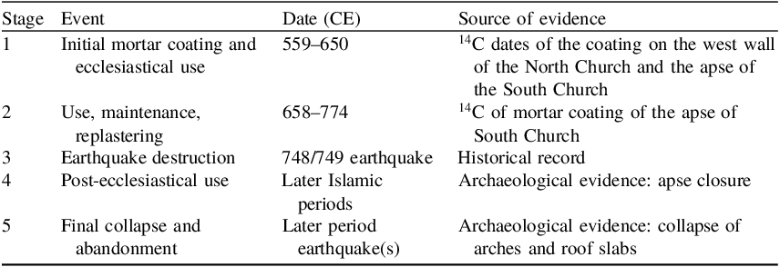
The 14C determinations, although few, reveal a clear chronology of the double church (Table 3); the first stage of its history began with its initial mortar coating sometime between 559 CE and 650 CE. Maintenance and re-plastering activities were required to handle decades of use and deterioration of the double church. These activities represent a second stage of the church’s history, which probably began after 650 CE and ended in 774 CE. However, it is worth noting that in 748/749 CE, a powerful earthquake struck the region and most probably caused some destruction to the double church. Excavations indicate that, at some point, presumably in the second half of the 8th century CE, the floor of the South Church was replaced with flat and rectangular stone slabs. The floor’s replacement is likely linked to or a sequence of the destruction caused by the above mentioned earthquake. This change in building style most likely represents a post-ecclesiastical use of the building, since some rectangular slabs of the chancel screen, with the decorated face up, were cut and reused in this pavement (Hamarneh et al. Reference Hamarneh2025). Additionally, the tombs uncovered during excavations beneath the floor were found to be empty, suggesting that the human remains had been relocated in the past to a different location. The post-ecclesiastical use of the double church represents a third stage of the chronology of the double church. Archaeological excavations revealed further supplementary building activities of post-ecclesiastical use of the churches: for example, the additional arch pillar made of small rubble stones attached to the southern corner of the apses, the separating wall of rubble stones between the eastern inner wall and the double pillar, as well as the wall built to close the apse off to the west. These building activities may point to the use of the church structures during the later Islamic period(s) (Abbasid, Fatimid and Ayyubid periods, and on top of the collapsed structures a Mamluk phase).
Suggested stages of construction, destruction, and collapse for the Double Church.

The North Church, discovered during the 2021 excavations, was found completely concealed beneath collapsed arches and thick layers of debris. Similarly, collapsed arches and roof slabs that completely concealed parts of the South Church were removed to clear the church’s bema. The final collapse, of unknown date, which probably resulted from a devastating earthquake, marks the end of the double church’s history. One or more of the powerful earthquakes that occurred in the area after the 748/749 CE earthquake, including the 1068 CE earthquake, among others (Amiran et al. Reference Amiran, Arieh and Turcotte1994; Russell Reference Russell1985, 47–49; Zohar et al. Reference Zohar, Salamon and Rubin2017), are candidates for the collapse and abandonment of the complex.
Conclusions
Radiocarbon analysis of mortar samples from the double church complex at al-Jumayil integrated with archaeological data and historical record, provides a refined chronology for its life stages. The construction (or the first plastering) of the double church between 559 and 650 CE, corresponds to the late Byzantine–Early Umayyad periods—a time of regional economic prosperity and widespread church construction. It agrees with the tentative archaeological date (second half of the 6th century CE) for its construction, suggested by stratigraphy and stylistic comparisons with the mosaics and architectural elements of securely dated churches. Numerous contemporary ecclesiastical foundations across the bishopric of Madaba and Provincia Arabia, including Khirbet al-Mukhayyat, Madaba, Umm er-Rasas, Jerash, and Rihab, support this dating through comparative architectural and epigraphic evidence.
Architectural evidence of the complex, including the interlocked walls of the North and South Churches, suggests both structures were built in close succession, if not contemporaneously. These findings align with broader patterns of church construction (and renovation) across the Levant from the late 6th to the early 7th centuries CE. The complex had a long life cycle, including its construction, ecclesiastical use, post-ecclesiastical use (as attested by the replastering), and destruction and collapse.
The structural collapse, which marked the end of the double church’s use and abandonment, is likely attributed to a major seismic event. One or more of the powerful earthquakes that struck the region after the well-documented 748/749 CE earthquake—such as the destructive quake of 1068 CE—are plausible causes for the church’s collapse and subsequent abandonment.
Acknowledgments
The authors acknowledge the Department of Antiquities of Jordan for its permission to conduct the study, the support of the Austrian Science Fund – FWF, Prof. Peter Steier and Dr. Monika Bolka of VERA (Vienna Environmental Research Accelerator) Lab of the University of Vienna for the 14C analysis.