INTRODUCTION
Preserved layers of tephra (volcanic ash) are valuable for reconstructing eruption histories, as isochrones for paleoenvironmental studies, and for investigating volcanic impacts on the environment. Alaska contains over 100 volcanoes that have been active during the Quaternary. Tephrochronologists have been studying volcanic ash stratigraphy throughout the Alaska Aleutian Arc, although many spatial and temporal gaps remain (e.g. Payne and Blackford Reference Payne and Blackford2008). South-central Alaska has several Holocene-age active volcanoes and has been subject to many historical ashfalls. This region is the most densely populated area in the state and is crossed by major international air routes, so even relatively modest eruptions can cause major impacts. Radiocarbon dating is widely used when studying the activity of volcanoes in the region around the North Pacific Ocean (e.g. Braitseve et al. Reference Braitseva, Ponomareva, Sulerzhitsky, Melekestev and Bailey1997; Zaretskaia et al. Reference Zaretskaia, Ponomareva, Sulerzhitsky and Dirksen2001; Fierstein Reference Fierstein2007). The area is also the site of ongoing paleoecological and archaeological studies, which use tephra layers for dating and correlating sequences (e.g. de Fontaine et al. Reference de Fontaine, Kaufman, Anderson, Werner, Waythomas and Brown2007; Wygal and Goebel Reference Wygal and Goebel2012; Zander et al. Reference Zander, Kaufman, Kuehn and Wallace2013). Tephra layers are commonly dated indirectly using 14C dating of bounding material including buried charcoal and wood fragments, peat deposits, and paleosols. Wood and charcoal fragments and organic-rich peat deposits are typically very good material for 14C dating (de Fontaine et al. Reference de Fontaine, Kaufman, Anderson, Werner, Waythomas and Brown2007). In south-central Alaska, Holocene loess deposits are common. Extensive deposits are related to strong winds, which shortened soil development, resulting only in Inceptisols with small amounts of organic matter, while only in wind-protected areas do soils develop into Spodosols (Muhs et al. Reference Muhs, McGeehin, Beann and Fisher2004). As a result, wood, charcoal, and peat materials are uncommon and paleosols, where present bounding tephra deposits, are primitive and underdeveloped with very low carbon content, in most cases less than 1% and often less than 0.3%. Low-carbon soils are a problem for 14C dating because even small traces of the foreign carbon can dramatically change the 14C age. The goal, then, is to identify the fraction of soil organic matter that is either not contaminated or least contaminated with foreign carbon.
14C dating of organic matter from buried soils can be a means to establish chronologies for geological and archaeological sequences, especially when deposits are devoid of materials such as charcoal, wood, and bone, which are generally expected to provide more accurate results for high-resolution chronologies. 14C provides a direct measure of the time elapsed since carbon in organic matter was fixed from the atmosphere by living organisms on the surface litter, among plant roots, and underground, which deliver carbon to the soil system. In our case, we observe soils in the initial stage of development with low carbon content. The 14C ages of the specific soil fractions should represent this short period.
The fractions of soil organic matter most consistently targeted for 14C dating are the base-soluble acids, or humic acids, and acid- and base-insoluble fractions, referred to as humin. Several researchers have shown that organic matter in loess is a naturally heterogeneous mixture of multiple fractions, such as folic acid, humic acid, and humin (Dodson and Zhou Reference Dodson and Zhou2000; Walker et al. Reference Walker, Bryant, Coope, Harkness, Lowe and Scott2001). These fractions have different 14C activities and residence times, which in turn may produce an apparent age that deviates from the actual age of the loess profiles. Therefore, it is generally accepted that these materials should only be dated for chronological purposes in the absence of reliable materials, such as charcoal, wood, or other plant macrofossils (Muhs et al. Reference Muhs, Ager, Bettis, McGeehin, Been, Begét, Pavich, Stafford and Stevens2003). In this study, we attempt to examine the applicability of bulk organic, humic acid, and humin fractions for 14C dating through detailed chronological work on typical loess soils with possible contamination by “old carbon” from coal deposits.
MATERIALS AND METHODS
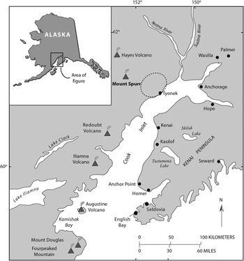
We collected a series of buried soils within soil-tephra stratigraphic sequences in south-central Alaska as an experiment to establish best practices for 14C dating of low-organic matter soils, which are common in this region. Seven soil samples were collected directly beneath Holocene-age (2000–7000 yr BP) tephra-fall deposits to determine the eruption or burial age. All samples were collected within 20 km of Mount Spurr Volcano located in south-central Alaska, about 125 km west of Anchorage (Figure 1). The presence of several large valley glaciers in the vicinity and occurrence of wind-blown deposits intercalated with tephra deposits suggest that this region has been very windy during the Holocene.
Map of the south-central Alaska showing locations of Cook Inlet volcanoes. Dashed outline represents approximate area of coal-bearing formations near Spurr Volcano.

The Beluga-Yentna coalfield is composed of 15,500 km2 of Cretaceous-age coal-bearing formations and is exposed in numerous valleys within about 25 km of the field stations where the buried soils were collected. Contamination of soils by local wind-blown coal material is a concern.
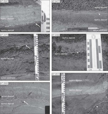
Soil development in some settings near the volcano is poor due to the high-latitude climate, limited vegetation cover, and frequent burial of developing soil surfaces by tephra fallout and eolian deposits. Typical soils in these environments are described as very primitive soils occasionally containing thin (1–2 mm) organic A1 horizons (see Table 1 and Figure 2).
Photographs of soil-tephra complexes showing paleosols buried by tephra fall deposits. Arrows point to paleosols.

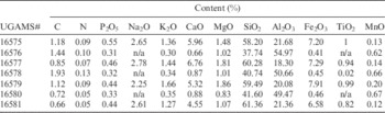
Chemical composition of the buried soils.

The seven paleosol samples include AT-2470 above tephra A; AT-2541 below tephra B; AT-2468 between tephras B and C; AT-2477 below tephra C; AT-2932 below tephra J; AT-2513 below tephra O; and AT-2942 below tephra Q. The chemical composition of these soils is quite diverging and could be explained by differences of the loesses and of ashes on which the soils were developed (Table 1).
There are a few ways to separate soil organic matter (SOM), which can be subsumed into two classes:
-
1) Physical separation, which is based on different composition and stability of the different size or density fractions (Six et al. Reference Six, Elliot and Paustian2000; Christensen Reference Christensen2001; Swanson et al. Reference Swanson, Caldwell, Homann, Ganio and Sollins2002). While SOM associated with soil aggregates may be stabilized by various other mechanisms such as occlusion, inaccessibility, and/or sorption, the stability of free or uncomplexed organics should be mainly controlled by its recalcitrance.
-
2) Chemical separation, which is based on the fractionation of SOM into their chemical compounds. The classic approach is the humus fraction scheme developed by Kononova (Reference Kononova1966) and modified by later studies (Chichagova and Cherkinsky Reference Chichagova and Cherkinsky1993; Cherkinsky Reference Cherkinsky1996; Wang et al. Reference Wang, Amundson and Trumbore1996), which differentiates humus fractions according to their solubility in acid and base solutions. Humic acids are formed in soils as products of decomposition of plant materials and exist in soils for thousands of years, providing them with stability and buffering. Although the non-specific humic compounds of SOM are often the most active, they control the specific biochemistry in any certain time period of soil formation. The important defining characteristics of soils are related to humic acids, so they record evolutionary changes that these soils have undergone during their existence.
In our study, we used chemical separation of SOM fractions, thus accounting for possible contaminations by coal dust, which could be reworked from local coal-bearing deposits. It is known that coal particles have a similar density as SOM and thereby could not be detected by physical fractionation.
In this experiment, we analyzed three fractions: (1) bulk soil samples after root separation by sieving through 125-μm nylon screen and following acid treatment with 1N hydrochloric acid at 80°C for 1 hr; (2) humic acid extraction by treatment with 0.1N NaOH solution for 24 hr at room temperature, followed by precipitation of the humic acids in acid conditions with concentrated hydrochloric acid, separation of the precipitant by centrifuging, and rinsing with Milli-Q™ water, followed by drying the humic acids overnight at 105°C; and (3) the remaining residue after humic acid extraction, which was treated with 1N HCl again at 80°C for 1 hr, rinsed with Milli-Q water, and dried at 105°C overnight. The pretreated samples were combusted in evacuated quartz ampoules in the presence of CuO at 900°C. The recovered CO2 was cryogenically purified and converted to graphite with an iron catalyst at 580°C (Cherkinsky et al. Reference Cherkinsky, Culp, Dvoracek and Noakes2010).
Accelerator mass spectrometry (AMS) measurement was performed at the Center for Applied Isotope Studies at the University of Georgia using a National Electrostatics Corporation (NEC) model 1.5SDH-1 Pelletron, which is capable of accelerating the +1 charged ions to about 1 MeV (Cherkinsky et al. Reference Cherkinsky, Culp, Dvoracek and Noakes2010). The stable isotope ratios for the samples were determined by use of the conventional MS-EA system Delta V.
RESULTS AND DISCUSSION
A total of 21 samples from seven paleosols were analyzed. The stable isotopes ratios and AMS 14C ages were determined on three different fractions extracted from paleosols within our soil-tephra stratigraphic sequences. The degree of soil development in the soil-tephra sequences was highly variable, ranging from soils in the initial state with 0.66% carbon, to quite well-developed soils with carbon content of about 2%. The elemental composition for these soils shown in Table 1 confirm the state of development of the different soils. For example, the alkali, alkaline earth elements, and phosphorus were completely or significantly leached from Spodosols and have quite high concentrations in soils in the initial state of development. On the other hand, elements such as aluminum and iron are accumulated in Spodosols more than in Inceptisols.
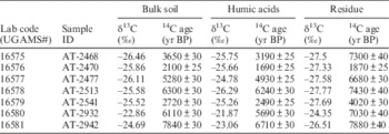
Our 14C dating and stable isotope ratio results are presented in Table 2. The interpretation of 14C dates of paleosols is generally difficult for the following reasons: The surface of a soil is an open system and, like a living organism, it exchanges 14C with the atmosphere. However, after a soil is buried (by wind-blown or other deposits), it stops this exchange and becomes a closed system (Jenkinson and Rayner Reference Jenkinson and Rayner1977; Cherkinsky and Brovkin Reference Cherkinsky and Brovkin1993; Gaudinski et al. Reference Gaudinski, Trumbore, Davidson and Zheng2000).
Radiocarbon age of different fractions separated from paleosols.

SOM is derived from different sources, which degrade into various products and are introduced at different times. As shown in many studies, different fractions of SOM have different turnover rates and correspondingly different 14C ages (Christensen Reference Christensen2001; Swanson et al. Reference Swanson, Caldwell, Homann, Ganio and Sollins2002). In addition, SOM is not always optimum for soil dating because of problems associated with the mean residence time of organic carbon and/or the variable rates of carbon accumulation. Although SOM is not typically preferred for providing good age estimations, it is very often the only dateable material found in such sequences because charcoal or wood are absent. Despite the described problems, similar soil-dating techniques as ours using humic acid extractions have been used by others in soil from Kamchatka, Russia and in Alaska, with good reproducibility and reliability (Fierstein Reference Fierstein2007; Zaretskaya et al. Reference Zaretskaya, Ponomareva and Sulerzhitsky2007).
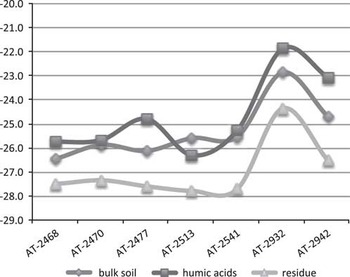
The distributions of the stable isotope ratios are significantly different among fractions (Figure 3). The residue fractions in all soils are relatively depleted while the humic acid fractions are consistently enriched compared to other fractions. Such a distribution is representative of the origin of these fractions. If the humic acid fractions originate from the decomposition of plant fragments and are specific to SOM, the fraction of humin could include not only chemically absorbed humus compounds, but also non-decomposed residues, and in our case, coal particles deposited with loess by wind.
δ13C distribution in different soil fractions extracted from individual paleosol samples. Each sample (AT-#) represents a single paleosol sample.

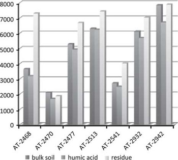
The age distribution among the various fractions is similar in all paleosol samples except AT-2470, which has a bulk carbon fraction that is older than all other fractions. This may be due to a higher concentration of coal particles (old carbon) in the sample and not equal their distribution. AMS 14C ages on the humic acid fractions are consistently younger than ages of both the bulk soil and residues after extraction. The difference in ages for the humic acid fraction relative to ages on bulk soil ranges from 60 to 1130 14C yr BP. However, in most of paleosol samples (five of seven), the difference is only between 230 and 460 14C yr BP. The age estimates on residue after extraction are 180–4110 14C yr BP older than the humic acid fraction ages, but five of seven paleosols have a difference in the range between 1170 and 1750 14C yr BP. In contrast to these results, our previous observations from dating different soil fractions showed that residue-after-extraction ages are typically younger than the ages on humic acid extracts, presumably because they contain younger plant material including modern roots (Christensen Reference Christensen2001). Based on the proximity of our field sites to coal-bearing deposits, and in agreement with the measured stable isotope ratios, we attribute the older ages of both the bulk soils and residues after extraction to contamination by old carbon from coal, probably introduced by wind.
The distribution of the ages for different fractions on Figure 4 shows that the humic acid ages are in very good agreement with the stratigraphy of the tephra layers, while the humin fractions fluctuate, more likely with climate variation, mostly with wind power and direction, which correspond to the eolian coal outflow.
Distribution of 14C ages for different paleosol sample fractions (HA: humic acids; H: soil residue fraction after extraction of humic acids).

CONCLUSION
Tephra deposits are used as distinct datum markers for soil formation. Dating the eruptions and studying the dynamics of the active volcanoes over the Holocene enable us to understand the periodicity of volcanic behavior and thus to predict long-term volcanic activity and associated hazards. Our results support the use of the humic acid fraction in AMS 14C dating of low-organic-matter soils in order to estimate the age of decayed organic material. This fraction is specific to each soil type and presumably marks the age of burial and correspondently the time of eruption. Our study also provides guidance on the careful dating of the bulk organic matter fraction of low-carbon soils, especially in regions with possible contamination by old carbon regardless of the source.
ACKNOWLEDGMENTS
This work was supported in part by the Center for Applied Isotope studies and Alaska Volcano Observatory. We wish to thank Jack McGeehin for review and correction of our manuscript. We also are grateful to our anonymous reviewers who made very useful comments for the correction of manuscript.