GLOUCESTERSHIRE
(1) Eastington, Nastend (SO 79208 06196): an archaeological excavation uncovered evidence for three phases of enclosure, including a late Iron Age phase, an early Roman phase (a.d. 50–120) and a second-century phase (a.d. 120–200). The exact form of the late Iron Age/Roman enclosures is unclear, as much of the central and northern parts of the site appear to have been truncated by modern ploughing. The truncation of the site also removed any internal features of the enclosure, although a piece of fired clay with a wattle impression found in a late Iron Age ditch suggests the presence of an oven structure nearby. Several environmental samples indicate that wheat was grown locally during the late Iron Age and during the second century. The animal bone from late Iron Age/Roman contexts indicates the presence of cattle and sheep/goat, with fewer specimens of pig, horse, dog and rodent. The pottery from the site consists mainly of Malvern area fabrics of the late Iron Age, while Severn valley ware was subsequently dominant. The Seven valley ware includes two vessels that were clearly ‘seconds’. These appear to be identical in fabric to a similar ‘second’ or waster vessel from Hunts Grove, Quedgeley, located 5 km north of the site. This may indicate that there was a relatively local production of Severn valley pottery in the area.Footnote 123
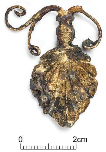
(2) Gloucester, Gloucester Bus Station, Bruton Way car park and Northgate Street (SO 83479 18637): an archaeological evaluation was undertaken. An area of extensive clay deposits was recorded in the south-western part of the site; this may have been caused by fluvial activity. Roman features and deposits included two probable surfaces, a transitional subsoil which contained a first-century gladius scabbard with a palmette mount (fig. 23) and two apparent post-holes, covered by various layers including demolition material.Footnote 124
Gloucester: palmette mount from a first-century gladius scabbard found within a Roman subsoil. (Photo: Oxford Archaeology)

(3) Hucclecote, Hucclecote centre: coins dispersed within the excavated fill of a pit a short distance south of the Hucclecote Roman villa were recovered: one illegible sestertius; one radiate or nummus and 11 nummi. Date of deposition: c. a.d. 321–24 or later.Footnote 125
(4) Innsworth (SO 852 212): an excavation was undertaken to the north-west of the village. Three areas were investigated (Areas 1–3). Area 3 to the north contained features associated with a small farmstead of probable late Iron Age date. These included a rectangular ditched enclosure and, within that, a square enclosure, which contained a roundhouse. An area of dense archaeology was uncovered in the southern part of the site (Area 1). A series of sub-rectangular enclosures of early to later Roman date, accessed by trackways, was recorded. Wells and waterholes, some very large, were exposed. Several of the features contained waterlogged deposits, preserving timbers and other organic objects, among them the remains of a barrel lining. To the east, in Area 2, a roundhouse of late Iron Age/early Roman date and field ditches of Roman date were recorded. A large quantity of finds was collected. This includes personal items, such as brooches, and many large, fresh pottery sherds and near-complete vessels. It is probable that activity represented on the site was associated with domestic settlement, although clear structural evidence was rare. A rich assemblage of environmental evidence, including waterlogged plant remains, pollen and insects, was also recovered.Footnote 126
(5) Tewkesbury, Coombe Hill, Tewkesbury Road (SO 8893 2723): an archaeological evaluation was undertaken. Evidence for Roman stone quarrying was identified on high ground in the south-western part of the site. This took the form of large, vertical-sided features which exploited seams of limestone, before being backfilled rapidly with upcast material. The quarrying could be related to the construction of the Roman road connecting Gloucester to Worcester and Droitwich which is projected to run past the site. Artefactual evidence recovered demonstrates a third- to fourth-century date for most of the activity, with a possible first- to second-century phase of quarrying suggesting prolonged exploitation of the natural resource. A quantity of building material including roof-tiles and possible tesserae is indicative of a high-status building in the immediate surroundings, while a possible curse tablet hints at a votive element to the landscape.Footnote 127
SOMERSET
(1) Banwell: coins were recovered from the excavated fill of a feature: 16 radiates including one of Gallienus (a.d. 260–68 under sole reign) and two of Claudius II (a.d. 268–70). Date of deposition: c. a.d. 270‒96.Footnote 128
(2) Compton Dundon: a hoard of 565 nummi. One Roman pottery sherd was reported with the coins. Date of deposition: c. a.d. 355 or later.Footnote 129
(3) near Ilminster: a hoard of 296 radiates, one denarius, one nummus and associated artefacts. The denarius is from the reign of Aurelian (a.d. 270–75). Five coins of the Tetrarchy (including the nummus) take the terminus post quem of the hoard to a.d. 296–97. Date of deposition: c. a.d. 296–97 or later.Footnote 130
(4) North Petherton: a hoard of 74 nummi. Date of deposition: c. a.d. 353–55 or later.Footnote 131
DEVON
(1) Bishop's Tawton, land south of Great Westacott Farm (SS 5810 2761): geophysical survey has confirmed the presence of a Roman auxiliary fort first postulated by Bryn Gethin in 2011 based on LiDAR observations.Footnote 132 Survey work is ongoing, but to date the results suggest either two phases to the fort or inner and outer contemporary defences, the larger measuring c. 150 by 130 m. Substantial extramural rectilinear buildings are evident, and there are suggestions that the whole complex may be enclosed by a further defensive circuit.Footnote 133
(2) Halberton (ST 02 13): geophysical survey and evaluation excavation has confirmed the presence of a Romanised building with at least one tessellated floor. This follows several seasons of gridded fieldwalking and metal-detecting. Survey work and analysis is ongoing.Footnote 134
(3) Ipplepen, Dainton Elms Cross (SX 8478 6650): excavation of a large open area investigated on the southern edge of a complex of enclosures visible on aerial photographs and geophysical survey.Footnote 135 Two complete middle to late Iron Age roundhouses were recorded, overlain by two substantial four-post structures, each set within a sub-square gully and associated with Romano-British pottery. These were in turn cut by three curvilinear gullies that contained iron-working debris. A nearby late Roman enclosure ditch contained a large amount of cattle bone (mostly from the head and feet of adult animals) and a piece of sawn antler.Footnote 136
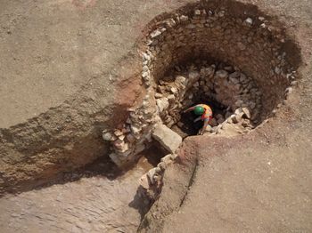
(4) Newton Abbot, Whitehill, Bovey Tracey Road (SX 8543 7232): excavations revealed a well-preserved Romano-British lime kiln. The lime kiln was cut into the hillside and comprised a 3.2 m-wide stone-lined circular chamber extending via a 1.5 m-long draw-hole into a 6 m-wide level working terrace (fig. 24). Within the working terrace was the grave of a female. Pottery indicates that the kiln was probably in operation from around the second to mid-third century. No evidence for nearby contemporary settlement was found but the kiln is located close to the projected line of the Roman road at Teignbridge following the route from Exeter to south Devon.Footnote 137
Newton Abbott, Whitehill: Romano-British lime kiln. (Photo: AC Archaeology)

PLYMOUTH
(1) Plympton: 91 nummi. Date of deposition: c. a.d. 324 or later.Footnote 138
CORNWALL
(1) Calstock, land adjacent to parish cemetery (SX 4350 6921): a community excavation outside the west gate of the previously identified Roman auxiliary fortFootnote 139 revealed further evidence for rubbish and cess pits, as well as a range of rectilinear timber buildings. The timber buildings lay on the southern side of a well-made road exiting the porta praetoria. A second trench was cut across the 8 m-wide road, which followed a natural geological break, and demonstrated that the northern roadside ditch effectively served as a quarry for the road bedding stone and the southern roadside ditch for the finer surface metalling. All dating evidence was consistent with a date of occupation of c. a.d. 50–80. A line of deep, undated, rectangular pits cut the course of the road; these are interpreted as relating to later historic mineral prospection.Footnote 140
(2) St Erth: hoard of two denarii and 73 sestertii and fractions. The denarii are one of the Republic (49 b.c.) and one of Hadrian (a.d. 117–38).Footnote 141 The sestertii and fractions range from Hadrian through to Julia Domna (a.d. 196–209). Date of deposition: a.d. 196–209 or later.Footnote 142
(3) St Levan V: hoard of 14 Iron Age gold staters and eight quarter staters, one base-metal Iron Age coin and five denarii. One of the 14 gold staters was inscribed ANTED. One of the quarter staters was inscribed COR. The denarii included one of the Republic, one of Augustus and one of Tiberius. Discrete groups of coins were found and are likely to represent sequential ritualised deposition over a large area.Footnote 143 Date of deposition: c. a.d. 68–69 based on the latest coin in the first group.Footnote 144
SUPPLEMENTARY MATERIAL
For supplementary material for this article please visit https://doi.org/10.1017/S0068113X20000458