There is little doubt that the acquisition and availability of airborne lidar (Light Detection and Ranging) datasets have revolutionized archaeology (Chase et al. Reference Chase, Chase, Fisher, Leisz and Weishampel2012), and the utility of lidar has increased as commercial datasets and derivative products become publically available. For some, lidar-derived products provide another avenue of data visualization that aids in understanding the spatial relationships among archaeological remains (Bennett et al. Reference Bennett, Welham, Hill and Ford2012; Challis et al. Reference Challis, Forlin and Kincey2011; Pingel et al. Reference Pingel, Clarke and Ford2015; Prufer and Thompson Reference Prufer and Thompson2016; Schindling and Gibbes Reference Schindling and Gibbes2014; Stark et al. Reference Stark, Evans, Rachna, Pihpal and Carter2015; Štular et al. Reference Štular, Kokalj, Oštir and Nuninger2012). For others, these datasets have allowed the identification and analysis of archaeological remains at regional scales in heavily vegetated environments that were previously unexplored (Chase et al. Reference Chase, Chase, Awe, Weishampel, Iannone, Moyes, Yaeger, Brown, Shrestha, Carter and Diaz2014; Yaeger et al. Reference Yaeger, Brown and Cap2016). Certainly, these two objectives are not mutually exclusive, and the use of lidar-derived imagery often encapsulates both goals. In fact, the technology has been of such influence that new finds routinely are made at some of the best-known archaeological landscapes in the world (Bewley et al. Reference Bewley, Crutchley and Shell2005; Evans and Fletcher Reference Evans and Fletcher2015).
These global developments in remote sensing have also been realized in the Pacific Islands. In Hawai'i, Ladefoged et al. (Reference Ladefoged, McCoy, Asner, Kirch, Puleston, Chadwick and Vitousek2011) and McCoy et al. (Reference McCoy, Asner and Graves2011) used lidar datasets to bridge previous survey data in order to understand regional patterning in archaeological data and document the full extent of prehistoric dryland and wetland agricultural systems. Building on this earlier research, Quintus et al. (Reference Quintus, Clark, Day and Schwert2015) applied a semi-automated feature extraction (AFEFootnote 1 ) technique to the heavily forested environment of Olosega Island, American Samoa, to document and analyze the distribution of residential terraces in a highly topographic environment. More recently, Freeland and colleagues (Reference Freeland, Heung, Burley, Clark and Knudby2016) used two AFE techniques in addition to more limited manual feature extraction (MFEFootnote 2 ) to map the distribution of mound features in the low-relief but vegetated landscape of Tongatapu Island, Kingdom of Tonga.
The basic utility of lidar imagery for archaeological research has been demonstrated, but questions persist regarding how far these applications can be pushed to examine different feature types and the analytical skill needed to identify archaeological features in different environments. Whereas previous researchers were often responsible for the processing of lidar point clouds (see Devereux et al. Reference Devereux, Amable, Crow and Cliff2005)—the raw datasets produced by any lidar investigation—the publication of processed data, often in the form of bare-earth DEMs (Digital Elevation Models; also known as DTMs [Digital Terrain Models]), and open-source data make the information more accessible to the archaeological community. Many practitioners of archaeology do not have the requisite knowledge of computer programming or access to specialized software that more easily enables the processing of raw lidar datasets. Because of this, and even though strides are being made to develop accurate and efficient AFE techniques (e.g., Freeland et al. Reference Freeland, Heung, Burley, Clark and Knudby2016; Schneider et al. Reference Schneider, Takla, Nicolay, Raab and Raab2015), the more common method to identify features remains visual interpretation using publically available lidar-derived imagery.
MFE has a potentially important role to play for these reasons, especially if the product can be shown to be analytically useful. Although previous research has shown the effectiveness of MFE for the simple identification of a wide range of archaeological features (Chase Reference Chase2016; Johnson and Ouimet Reference Johnson and Ouimet2014, Reference Johnson and Ouimet2016; Štular et al. Reference Štular, Kokalj, Oštir and Nuninger2012), very little research has focused on the analytical potential of these data. Here, we analyze a publically available DEM derived from a lidar dataset of Ta'u Island, American Samoa, to examine the validity and utility of MFE. We compare the visual interpretations of three individuals (the authors) to the results of a field-based mapping program. We seek to address two questions: (1) is MFE an effective means of documenting anthropogenic landscape modifications; and (2) does assigning a confidence rating to manually extracted features provide analytically important information?
STUDY AREA
The island of Ta'u is located in the West Polynesian archipelago of Samoa, which is divided into two modern political units: the Independent State of Samoa in the west and the US territory of American Samoa in the east. American Samoa is itself separated into two groups. The islands of Tutuila and Aunu'u form one group in the western half of the territory, and the islands of Ofu, Olosega, and Ta'u collectively form the Manu'a Group to the east (Figure 1). The uninhabited Rose Atoll and Swains Island are also part of American Samoa.
Manu‘a Islands with the area of interest outlined.

The islands of the Manu'a Group are small even by Polynesian standards. Ta'u is the largest at 36 km2, with the smaller islands of Ofu (7.3 km2) and Olosega (5 km2) located some 10 km to the northwest. These islands are volcanic in origin and feature high topographic relief. Slopes range from near flat along the coastline to between 5 and 40° within the habitable areas of the interior. Their youthful age, less than 300,000 years (McDougall Reference McDougall2010), has precluded the development of dissected valleys, but some streams have formed, which run following heavy precipitation events. Given the amount of precipitation that the islands receive (more than 3,000 mm annually), vegetation cover is dense, especially in the interiors of these islands, where canopies can grow as high as 25 m (Whistler Reference Whistler1992:14). Much of the vegetation is the result of human manipulation, and forest in the interior portions of all islands in Manu'a includes a high proportion of secondary and economic species (Liu et al. Reference Liu, Gurr, Schmaedick, Whistler and Fischer2011; Whistler Reference Whistler1992).
While archaeological research has been conducted on the coast of Ta'u (e.g., Addison Reference Addison2008; Cleghorn and Shapiro Reference Cleghorn and Shapiro2000; Hunt and Kirch Reference Hunt and Kirch1988), knowledge of the interior uplands is limited (but see Clark Reference Clark1990; Herdrich et al. Reference Herdrich, Moore, Kilzner and Kennedy1996). The documentation of the full range and distribution of features in these areas is impeded by several factors. The most important of these is the density of vegetation that limits the size of survey programs, but the lack of easy accessibility to some areas also hampers efforts. Fortunately, most of these archaeological features are landscape modifications visible in imagery derived from a lidar dataset (Quintus et al. Reference Quintus, Clark, Day and Schwert2015).
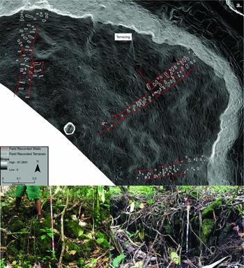
This article concerns the northeast corner of the interior uplands of Ta'u on the Luatele formation (Figure 2). The area is situated above the modern village of Fitiuta, downslope and seaward of a late Pleistocene volcanic crater (Luatele). Archaeological remains are found in an elevation range between 100 and 375 m with slope values from 5 to 25°. The area includes dense vegetation comprised of secondary (e.g., Hibiscus tiliaceus) and economic species (e.g., Cocos nucifera) and is bounded on the northwest and southeast by stream banks.
(a) results of the initial 2015 pedestrian survey in the Luatele site; (b) stone retaining wall of terrace in foreground, terrace in the background; (c) stone wall running seaward-inland.

Residential/agricultural terraces and stone/earth walls or embankments are the most common archaeological features in the project area. The walls, embankments, or low linear mounds range in width from approximately 1 to 3 m and in length between approximately 20 and 450 m. In the project area, these features run both parallel and perpendicular to the slope. Their function is a matter of some speculation but, based on regional analogy (Ladefoged et al. Reference Ladefoged, Graves and McCoy2003; McCoy and Hartshorn Reference McCoy and Hartshorn2007), these might have served to mark boundaries between social units or agricultural fields, reduce erosion, or act as surfaces for cultivation. Terraces in Samoa vary by size and morphology, but, in general, are defined as flat features with 2–3 free-standing sides. While those on Ofu and Olosega are constructed of earth with minimal stone facing, those on Ta'u, at least in the project area, exhibit a relatively higher proportion of stone. These features likely served a variety of functions, ranging from domestic sleeping and eating quarters to foundations for resting and/or working during slope cultivation. The discrimination of function has been difficult, but previous researchers have posited that the presence of secondary features (e.g., coral or waterworn basalt paving, curbing stones) might be used as an indicator of domestic function (Quintus Reference Quintus2015; Quintus and Clark Reference Quintus and Clark2012). The identification and analysis of terraces is the subject of this study.
METHODS
Aerial lidar data were collected for American Samoa in June and July of 2012 by the National Oceanic and Atmospheric Administration (NOAA) Coastal Services Center in collaboration with the American Samoa Government Department of Commerce and the US National Park Service (Raber Reference Raber2012). Data were collected by Photo Science, Inc., using an Optech lidar system at a height of 1,219 m. Line spacing occurred at 395 m with 50% overlap. Average point spacing was 1.43 pts/m2 with a maximum point spacing of .838 m and a root mean square error of 0.074. Point clouds generated from data collection were processed and classified, also by Photo Science, Inc., in TerraScan and TerraModeler. It should be noted that classification is an imperfect process. Areas of thick vegetation, like those within the project area, can reduce the density of ground returns, and low vegetation might be erroneously classified as bare-earth returns. It is from these bare-earth or ground-classified returns that a DEM (or DTM) was created resulting in a raster with 1 m pixel resolution and better than 15 cm vertical accuracy. This research made use of this open-source DEM (DTM) that is publically available through NOAA with associated metadata.
The three authors have variable experience in the archaeology of the region and the use of GIS for the analysis of spatial datasets. One has extensive experience investigating the interior uplands of the Manu'a Group and has modest experience using lidar datasets for the identification and analysis of archaeological features (R1). Another has extensive experience working with spatial datasets, with a particular expertise in aerial and terrestrial laser scanning systems, and modest knowledge of the archaeology of the interior uplands of Manu'a (R2). The final author (R3) is a student with limited experience in the archaeology of the interior uplands and analysis of lidar datasets, but extensive knowledge of GIS.
Pedestrian survey data used for ground-truthing purposes were collected prior to digital survey during July of 2015 by a crew of four individuals spaced 10 m apart. Terrace features were recorded from three transects that spanned the length of the field and settlement system in the seaward:inland direction (Figure 2). Each feature was outlined as a polygon using iGIS on an Apple iPad tablet with < 5 m accuracy (error range provided by software). Maximum length and width measurements taken in the field with a 30 m tape were compared with these outlines. Photographs were taken of each feature, and other relevant information was recorded (e.g., presence/absence of retaining wall or secondary features). After fieldwork was complete, feature polygons were manually smoothed in ArcGIS to limit the effects of GPS error. Feature area was measured in two ways, by multiplying length by width and by using the geometry tool in ArcGIS after the feature polygons had been modified.
Roughly a year after pedestrian survey, each author was provided with the approximate location of the settlement zone and a copy of the lidar-derived DEM. All derivative products (i.e., slope maps, hillshades) were created using the spatial analysis toolkit in ESRI ArcGIS 10.3. The hillshades (grayscale images of surface topography that use the sun's relative position for shading), created by each author, used variable azimuths and altitudes to model the sun's relative position. Slope maps with a Z-factor of 1 using stretched (percent clip) display in grayscale and in color were generally most useful. The authors also found it useful to classify the slope map in ArcGIS using a two-class technique (one class below 10–15° slope and the other above this). This method of visualization is similar to that successfully employed previously in Oceania (McCoy et al. Reference McCoy, Asner and Graves2011; Quintus et al. Reference Quintus, Clark, Day and Schwert2015). R1 and R2 had knowledge of features in the project area, as these authors were part of the crew that mapped the field features used in this research for ground-truthing purposes, but digital feature identification was independent of these previously recorded field data (blind identification). Neither R1 nor R2 knew the exact location or number of terrace features prior to the completion of digital identification, though both did have knowledge of feature morphology.
All digital identifications were completed independently of the other authors within a set time period (approximately two weeks). Each author assigned a three-scale (high [3], medium [2], and low [1]) confidence rating to each digital feature identified. Those rated high were features that the researcher thought had a >75% chance of being a terrace based on morphology and location; those in the medium category were rated to have a 50–75% chance of being a terrace; and those in the low category were thought to have a < 50% chance of being a terrace but still had some morphological attributes (e.g., contiguous areas of low slope) that suggested they could be anthropogenic features. Finally, a cumulative confidence rating was assigned to each digitally identified feature, adding the confidence ratings of each author together if more than one author identified the feature. This cumulative score ranged from 1 to 9.
The field and digital datasets were integrated into a single GIS and compared. If digitally identified features of two or more authors overlapped, they were noted as a positive identification. Positive identifications were further categorized based on whether that identification was one-to-one (Figure 3) or multiple-to-one (Figure 4) (overlap features; multiple features identified by one author fitting within one feature identified by another). These same principles were applied to the comparison between digitally identified features and those mapped in the field. From this analysis, we focused on and calculated the rate of true positives (TP), false positives (FP), and false negatives (FN) (Table 1). This was done so that the results of identification could be quantitatively assessed using the F1 measure (Freeland et al. Reference Freeland, Heung, Burley, Clark and Knudby2016). This is a measure of the accuracy of a binary classification that relies on the calculation of the harmonic mean of sensitivity (R) and the precision (P) (Table 1).
 $$\begin{equation*}
{{\rm{F}}_{\rm{1}}}{\rm{ = 2PR/}}\left( {{\rm{P + R}}} \right)
\end{equation*}$$
An example of positive identification between field and digitally identified features overlying slope map.

An example of a multiple-one (overlap) positive identification overlying slope map. The smaller features were given separate feature numbers and referred to as overlap features.

Definitions of Terms Used in the Text.

This measure, as opposed to the use of confusion matrices, does not take into account true negative results; these were not considered since the project was not able to quantify this in any meaningful way (area of each transect that did not include terracing would not be a realistic measure of true negative). The closer the score is to 1, the better the classification.
RESULTS AND ANALYSIS
Results of Surveyed Tracts and Comparison with Field Data
In total, 161 terraces were identified in the three field transects using pedestrian survey; these have a mean area of 110 m2. Of those terraces identified, 55 were identified in Transect 1 (T1), 59 in T2, and 47 in T3. Terraces in each transect exhibited slightly different characteristics, notably in terms of size and variance, which is probably the result of functional differences and social processes (e.g., residential status) (Table 2). Even though these terrace samples are significantly different (F = 13.48; p < 0.01Footnote 3 ), all three transects include a similar number of terraces that measure less than 200 m2 (T1 = 46; T2 = 49; T3 = 47). T2 included more terraces measuring over 200 m2 than any other transect, with no terrace over 200 m2 identified in T3.
Descriptive Statistics of Features in Each Transect.

a After combining the datasets of the three authors.
Each author digitally identified a variable number of features within the boundaries of these three transects. In total, R1 identified 145 (average area = 140 m2) features, R2 identified 103 (average area = 65 m2), and R3 identified 81 (average area = 144 m2). In all three cases, TP outnumbered FP by a substantial number (Table 3). However, precision and sensitivity ranged considerably among the authors, and the number of FN recorded by each was over 45.
F1 Score Assessment of Feature Extraction.

Results were more successful when author identifications were considered together. Because many of the digital features were recorded by more than one author, the total number of individual terraces identified was 181. Seventy-seven percent of the features identified in the field were identified by at least one of the authors. The vast majority of FP were recorded only by one, instead of more than one, author (70%), while TP were often recorded by two or three authors collectively (Table 4). Of the features identified by all three authors (n = 53), 94% were TP. Given the rate of TP within this group, it might be that three other features identified by all three authors are TP but were not recorded during field survey, given low visibility in this densely vegetated environment. Not surprisingly, the cumulative confidence ratings were related to the rate of TP and FP, with TP representing 90% of features with cumulative confidence ratings of 3 or higher (87 of 97) (Table 5). The results of feature identification, however, were not even across the three transects (Table 6). Instead, the ratio of TP to FP was highest in T2, which also had a low number of FN (n = 5).
The Differences in True and False Positive Rates When One or Multiple Authors Identify a Feature.

The Relationship between Confidence Rating and True and False Positive Rates.

The Relationship between Transect Number and the Results of Feature Identification.

The average size of terraces that were FN is significantly smaller than those that were positively identified (U = 989; z = 5.24; p < 0.01Footnote 4 ). In other words, larger terraces were more accurately identified than smaller ones. Not surprisingly, but even more telling, the average size of digital features (average of three authors’ feature outlines) is correlated with cumulative confidence rating (n = 181; rs = 0.47; p < 0.01Footnote 5 ). This signifies that the authors themselves were more confident in the identification of larger features. The impact of average size is confirmed by the significant increase in the sensitivity of identification when field features that measure less than 75 m2 are excluded from analysis (Table 3).
The methods used to manually identify features relied heavily on the contrast between the slope of terraces and that of the surrounding area (similar to McCoy et al. Reference McCoy, Asner and Graves2011; Quintus et al. Reference Quintus, Clark, Day and Schwert2015). Because of this, it was predicted that surrounding slope might have been a limiting factor in identification; terraces that exhibit less contrast with the surrounding slope would be more difficult to identify. This was assessed by calculating the average slope within a 10 m buffer surrounding field-observed terraces, with the overlaps between buffers of different terraces dissolved. The results suggest that there are no differences in the slope of areas surrounding terraces that were positively identified (mean = 15.71) by the authors and those that were not (mean = 15.43; U = 2280; z = −0.05; p = 0.96). Therefore, slope does not appear to have been a factor in feature identification in this study.
For remotely sensed features to be analytically important, they must be reasonable representations of on-the-ground features. A correlation between the field-acquired and remotely sensed data on terrace size discussed here is generally supported by the similarity of sample meansFootnote 6 (n = 103; Field = 123, Digital = 124; U = 5035; z = −0.63; p = 0.53), but this might mask significant individual feature-level variation. To assess the relationship between field and digital features in our dataset at a finer scale, we compared terrace area measured in the field to that measured digitally using features with a one-to-one positive identification (n = 103). Simply, we calculated a proportion statistic (field-measured area/average digitally measured area), subtracted that statistic by 1 to examine distance from a perfect correlation, and then made all numbers positive. The resulting average distance away from a perfect correlation was 0.47. In other words, the field-measured area was roughly 47% larger or smaller than that measured digitally. While this seems large, the mean is affected by a set of outliers with proportions over 1.5, and the median measures 0.28. Moreover, there is a strong negative correlation between confidence rating and variation, with those terraces possessing higher confidence ratings exhibiting less variation from the field measurements (n = 103; rs = −0.40; p < 0.01). These differences might also reflect the subjective placement of vertices by the authors (see Figures 3 and 4). Still, it appears that there is a general correlation between the field and digital dataset, and that confidence ratings can be used to predict variation between digital and field data.
Results of Non-Surveyed Tracts and Intergroup Comparison
Similar methods of identification were used to digitally survey previously unexplored regions of the Luatele site, with all authors surveying the same area. R1 identified 701 features as terraces, R2 identified 752, and R3 identified 484. On average, these features measured 99 m2, 61 m2, and 111 m2 respectively, and these differences in terrace size among samples were significant (F = 55.15; p < 0.01). As was the case with feature identification in field-surveyed areas, each author assigned a confidence rating to their identifications. The details of these identifications are provided in Table 7.
Attributes of Identified Features Also Identified by Another Author.

a Feature was identified by at least one other researcher.
The majority of terraces documented by each author were documented by at least one other author, with the rate of repeat identification ranging from 67.4% (R2) to 82.4% (R3). As would be expected, the repeat identification rate correlates with the confidence rating assigned by each author. The rate of repeat identification ranged from 83.1% (R1) to 100% (R3) for high confidence features, from 65% (R1) to 91.5% (R2) for medium confidence features, and from 52% (R2) to 68.7% (R3) for low confidence features (Table 7).
The combination of the three datasets resulted in the identification of 1,111 individual features, 1,009 of which either were identified by a single author or were one-to-one positive identifications identified by multiple authors. One hundred and two were overlap features. While these were not considered cases of one-to-one identifications, they were considered positive repeat identifications in reference to the individual author datasets. A total of 477 features were identified by more than one researcher (mean = 95 m2), while the remaining 532 were recorded by only one researcher (mean = 53 m2). Those recorded by one researcher were significantly smaller than those recorded by multiple researchers (U = 194005; z = −14.5; p < 0.01). As was the case in regards to field data, there is a strong positive correlation between confidence rating and average surface area (n = 1009; rs = 0.63; p < 0.01). Those terraces possessing a combined confidence rating of three or more (n = 483; mean = 100) are larger than those with combined confidence ratings of two or less (n = 526; mean = 48; U = 207071.5; z = −17.31; p < 0.01).
An analytical dataset was created for further analysis and comparison that included those features that were identified by more than one researcher or were assigned a cumulative confidence rating of three or more. These attributes were chosen based on the ground-truthing results. Namely, a high percentage of features with cumulative confidence ratings of three or higher were true positives (90%), which was also the case for features identified by two or more researchers (83%). Unfortunately, it is likely that this dataset includes a small proportion of FP and excludes a small number of FN. Two separate analytical datasets are considered: one that includes overlap features (cumulative analytical dataset; n = 637) and one that does not (analytical dataset; n = 535).
The proportion of terraces of different size classes is comparable between the field and analytical datasets (Figure 5), hinting that the digital sample is a valid representation of the terrace population. Furthermore, the mean of the analytical sample (n = 535; mean = 96) is similar to that of the field sample (n = 161; mean = 110), though differences between the samples are significant (U = 47410, z = −1.94, p = 0.05). The differences between the cumulative analytical dataset (n = 637; mean = 101 m2) and field dataset are not significant (U = 54066, z = −1.07, p = 0.28).
Comparison of terrace sizes measured in lidar and the field. Note the discrepancy under 100 m2.

Digitally measured features are smaller on average relative to those measured in the field. There could be several reasons for this slight discrepancy, including that the digital datasets include an underestimation of terrace size or that the difference reflects real variation in features found throughout the project area. The latter is more likely, as the digital datasets include more terraces from higher elevations relative to the field dataset. Smaller terrace sizes have been demonstrated to correlate with higher elevations elsewhere in Manu'a (Quintus Reference Quintus2015; Quintus and Clark Reference Quintus and Clark2016).
DISCUSSION
Archaeologists are an adventurous lot. We explore remote locations for evidence of past human activity. However adventurous we are, some environments exhibit more difficult conditions of site-prospecting than others, and it is not always possible to achieve 100% coverage, especially across large spatial scales. Tropical rainforests, including those throughout American Samoa, have been especially problematic for traditional field-based prospecting techniques, given the dense vegetation cover that masks even large structures. It is in these environments that the use of airborne lidar has been particularly helpful (Chase et al. Reference Chase, Chase, Fisher, Leisz and Weishampel2012; Freeland et al. Reference Freeland, Heung, Burley, Clark and Knudby2016; Ladefoged et al. Reference Ladefoged, McCoy, Asner, Kirch, Puleston, Chadwick and Vitousek2011; McCoy et al. Reference McCoy, Asner and Graves2011; Opitz et al. Reference Opitz, Ryzewski, Cherry and Moloney2015; Quintus et al. Reference Quintus, Clark, Day and Schwert2015). As an attempt to build on this recent research, this article has sought to evaluate the utility of MFE using preprocessed and publically available DEMs. Notably, we have demonstrated the effectiveness of commercial grade airborne lidar datasets for use in identifying and analyzing archaeological landscapes in forested environments (see also Howey et al. Reference Howey, Sullivan, Tallant, Kopple and Palace2016). Moreover, we have documented that digital surveys using lidar-derived DEMs, simple MFE techniques, and limited training can provide positive results (F1 score of 0.72). However, this exercise was not perfect, errors were common, and limitations were demonstrated.
It should also be noted that feature and measurement ambiguity is not unique to digital survey. As all practicing archaeologists know, field survey suffers from ambiguity as well (e.g., measurements, feature interpretations, etc.). For example, both field and digital measurements suffer from surrounding “noise.” In the field, this noise is created by the dense tropical vegetation present in the project area. As mentioned above, it is conceivable that we failed to field-record three features later digitally identified as terraces by all three authors as a result of vegetation. Noise in digital settings is created by difficulties processing all vegetation returns out of an image, especially when vegetation is near ground surface, as well as by the error range built into datasets and images used in the analysis (resulting from the creation of the DEM or by rounding surfaces with steep sides). At least some of the FP identified by the authors might have been caused by areas of contiguous, thick, and low-lying vegetation classified as bare earth (see similar situation in Reese-Taylor et al. Reference Reese-Taylor, Hernández, Esquivel, Monteleone, Uriarte, Carr, Acuña, Fernandez-Diaz, Peuramaki-Brown and Dunning2016). The elevation difference between the actual surface and this vegetation might have caused these areas to appear anthropogenic. Because of this, digital and field measurements allow for a check of each other.
Based on ground-truthing results, MFE is more accurate when the identifications of multiple researchers are combined. Our quantitative results confirm that the analysis of a single user includes lower levels of precision and sensitivity, no matter their knowledge of feature morphology. It is essential, based on these results, that researchers applying MFE techniques use and compare the identification interpretations of multiple individuals.
Our results also document some factors that might impact variation in identification. For the terrace feature class on Ta'u, the most pronounced limitation is feature size, with the identification of terraces smaller than 75 m2 being ambiguous. These small terraces constituted the majority of both FP (77%) and FN (78%) even though they represented only 45% of the collective digital and 42% of the collective field datasets. When terraces of 75 m2 or less were excluded from comparison, the sensitivity of feature identification improved dramatically, though precision dropped because there was a higher ratio of FP to TP. While it was originally thought to be an important factor, the slope values of the surrounding landscape do not appear to have had an effect on the results of feature identification in this case. However, it might be that the contrast between slope and terrace becomes more pronounced with larger features; this lack of visible contrast in small features might be a reason why they were difficult to identify. The density of vegetation in some of these areas might also be a key factor in feature identification and the quality of the lidar dataset, though this cannot be assessed here since we used a publically available DEM. These limitations are in part reconciled by the use of confidence ratings. These ratings are often thought of as subjective evaluations, but we contend and have shown that they provide a means to further refine the results of feature identification when they are assigned in a systematic way and have consistent definitions. Researchers must weigh increased sensitivity against decreased precision.
Even with the limitations discussed above, our results indicate that datasets built through MFE can be analytically important. In our datasets, most features with higher confidence ratings were better approximations of the field features than those of lower confidence ratings; those features identified by a single researcher as low confidence were particularly problematic. The blind identification of features by three separate individuals, along with confidence ratings, allowed us to examine the archaeological landscape beyond what has been previously surveyed in the Luatele site. The utility of this is demonstrated by comparison with the broader archaeological landscape of Samoa.
Comparison with Previous Landscape Studies in Manu'a and Regional Implications
The availability of airborne lidar datasets in Oceania has been increasing rapidly. Focusing on Samoa, this ability to survey large tracts of land under tropical vegetation has already proven groundbreaking; airborne lidar is becoming an essential tool for cultural resource management. Several extensive, but previously under-researched, areas in Manu'a have been documented through visual investigation of lidar-derived imagery, including Luatele on Ta'u and Sili-i-uta on Olosega. As modern development continues to intrude on these interior landscapes, airborne lidar will serve as a valuable tool to ensure that cultural resources are identified and sufficiently protected.
With the addition of this analysis, at least partial investigations of interior archaeological landscapes have now been completed on all three islands of the Manu'a group (Quintus Reference Quintus2011, Reference Quintus2012, Reference Quintus2015; Quintus and Clark Reference Quintus and Clark2012, Reference Quintus and Clark2016; Quintus et al. Reference Quintus, Clark, Day and Schwert2015). These areas, which include the vast majority of habitable land on each island, were virtually unknown just 10 years ago. What has become apparent is the near continuous distribution of archaeological remains across the landscape. Given the size of the islands in Manu'a, the sheer density of terracing speaks to the size of the prehistoric population and the carrying capacity of these environments.
As elsewhere in the world, the examination of variation within and among settlement zones has led to advances in our understanding of a range of social practices in Manu'a (Quintus Reference Quintus2012, Reference Quintus2015; Quintus and Clark Reference Quintus and Clark2012, Reference Quintus and Clark2016; Quintus et al. Reference Quintus, Allen and Ladefoged2016). The localized nature of archaeological investigation prior to the availability of lidar in the archipelago largely prohibited this type of comparative analysis. Of particular importance in the analysis of variation, average terrace size differs significantly between documented settlement zones, which are perhaps comparable to the Samoan nu'u, or, roughly, village, on the three islands. Whereas there is broad comparability in average terrace size between one settlement zone on Olosega (Sili-i-uta) and the two on Ofu (A'ofa and Tufu), one settlement zone exhibits larger terraces (Tamatupu on Olosega) and one has smaller terraces (Luatele on Ta'u) (Table 8). The range of terrace sizes is consistent between all but Tamatupu (Figure 6), though a higher proportion of small terraces appear to be present in Luatele relative to other settlement zones (Figure 7). On almost all accounts, Tamatupu is an outlier in the Manu'a group.
Comparison among the Documented Settlement Zones of Manu'a.

Comparison between documented settlement zones in Manu'a. The Luatele sample is the comprehensive dataset (field and all digital features).

Comparative histogram of the five settlement zones documented in Manu'a.

The difference between Tamatupu and the other settlement zones has been hypothesized to relate to political considerations (Quintus et al. Reference Quintus, Clark, Day and Schwert2015). This is based not only on the proportion of large terraces that might reflect status but also on the number of star mounds, local examples of monumental architecture (Herdrich and Clark Reference Herdrich, Clark, Graves and Green1993), associated with the settlement zone. In contrast, the smaller average terrace size in Luatele might relate to differences in activities undertaken in at least portions of the zone. Luatele is unique in Manu'a in that small linear mounds of earth and stone are situated running both perpendicular and parallel to the slope. It might be that the smaller terraces relate to activities associated with these linear mounds, namely food production. Such an interpretation could be assessed with additional pedestrian survey to gather data on feature function. Alternatively, it might be that the smaller average terrace size in Luatele is a product of error associated with digital feature measurement. This is unlikely to explain the entire variation apparent between Luatele and other settlement zones, though, especially given the general comparability between field-based measurements and digital-based measurements discussed above.
The discovery and preliminary documentation of interior upland settlement zones in Manu'a hints of significant unknown archaeological landscapes on the larger islands of the archipelago. This has already proven true for Tutuila (Cochrane personal communication), but airborne lidar datasets are just becoming available for the Independent State of Samoa. Vast tracts of archaeological features have already been documented in some areas of ‘Upolu and Savai'i (Holmer Reference Holmer, Jennings and Holmer1980; Wallin and Martinsson-Wallin Reference Wallin and Martinsson-Wallin2007), but the vast majority of land on each island remains unexplored. If the density of archaeological remains on adjacent Manono is any indication (Sand et al. Reference Sand, Bole and Baret2012), we can expect important finds to be made if/when airborne lidar data is analyzed. We are hopeful that continued demonstration of the utility of commercial quality airborne lidar datasets serves as a proof-of-concept to justify the acquisition of comparable datasets by small island nations.
CONCLUSION
With the results of this research in mind, we make the following recommendations about the use of lidar datasets in archaeological research, especially in regards to MFE:
-
1. Airborne lidar should be paired with pedestrian survey data and the process of feature interpretation should be iterative (following Freeland et al. Reference Freeland, Heung, Burley, Clark and Knudby2016; Opitz et al. Reference Opitz, Ryzewski, Cherry and Moloney2015; Quintus et al. Reference Quintus, Clark, Day and Schwert2015; Reese-Taylor et al. Reference Reese-Taylor, Hernández, Esquivel, Monteleone, Uriarte, Carr, Acuña, Fernandez-Diaz, Peuramaki-Brown and Dunning2016).
-
2. Projects employing MFE should include multiple individuals who undertake feature identification independently of other researchers.
-
3. Systematic and well-defined confidence ratings should be assigned for all identified features as a quality-control mechanism.
-
4. The relationship between field and digital data should be assessed quantitatively.
-
5. The analysis of datasets derived from digital survey that makes use of airborne lidar should provide a set of working hypotheses from which expectations and predictions can be formulated, evaluated, and refined as additional pedestrian survey data are acquired.
We agree with the arguments of previous researchers that the most effective use of lidar datasets is in conjunction with traditional field survey (after Optiz et al. Reference Opitz, Ryzewski, Cherry and Moloney2015), and that remote sensing does not and should not replace localized pedestrian survey (Freeland et al. Reference Freeland, Heung, Burley, Clark and Knudby2016). The data collected by different techniques do not necessarily overlap, as they are situated at different analytical scales. Pedestrian survey remains an important tool for documenting the range of sites, both standing and dispersed, within a region. In the case of Samoa, this is important, as secondary features (e.g., foundations, pavings, artifacts) have important implications for feature function analysis, as discussed above. In other regions of the world, lack of pedestrian survey might mask variation in construction materials, artifact densities, and other important data frequently used by archaeologists. However important lidar data might be, it is essential to recognize these limitations. Field and digital surveys are complementary tools, and it is the use of these strategies as complementary tools by all archaeologists that presents an opportunity for the addition of lidar to prove revolutionary in archaeology.
Acknowledgments
We thank the people of Ta'u for allowing us to conduct research on their island. Permits were not required for this project. We thank Nolita Motu for her assistance during fieldwork and Jamie Viteri for translating the abstract. We are grateful for the critical comments provided by Donald Schwert, Miram Stark, and four anonymous reviewers on an earlier draft of this manuscript.
Data Availability Statement
All data files will be made publically available online (https://www.ndsu.edu/researchgroups/samoanarchaeology/).