Introduction
Temporal patterns of suspended-sediment flux and meltwater discharge in streams draining from alpine glaciers during the ablation season indicate how meltwater flowing through the developing subglacial drainage system interacts with sediment produced by glacial erosion. Disproportionately large amounts of suspended sediment are transported as discharge increases early in the ablation season, by comparison with the loads moved by subsequent higher flows (e.g. Østrem, 1975; Collins, 1990). The seasonal sediment-flux pattern is punctuated by sudden peaks that result from subglacial hydrological events, during which much sediment is Hushed as the wetted area expands rapidly to impinge on zones of accumulated unworked sediment on the subsole (Collins, 1989). Significant events occur during sustained rising discharge, when flow exceeds previous levels or is restored following recession, and as a result of heavy rainfall and release of drainage pathway constrictions. Apparently, water is supplied rapidly to the basal drainage network at a rate greater than the system has the capacity to discharge. Hence, flow backs up and water pressure increases. Water may be forced to spread out over the subsole, and configuration, dimensions or position of existing pathways may be altered.
In order to demonstrate the role of water pressure in sub-glacial hydrological events, combined continuous measurements of borehole water levels and portal meltwater quantity and quality characteristics are necessary at times when the drainage network has to adapt to sudden increases in meltwater supply. In 1993, such a combined measurement programme was under way at Findelengletscher, Pennine Alps, Switzerland (Fig. 1). Towards the end of the ablation season, between 22 and 24 September, rainstorms that produced floods with about 20 year recurrence intervals in rivers throughout the Swiss Alps (Landeshydrologie und -geologie, 1994) resulted in a major subglacial hydrological event. The aim of this contribution is to describe and explain the interaction between water pressure in the basal drainage system and discharge before and during the event. The impact of the flood on the drainage system and sediment stored at the glacier subsole is also assessed.
Methods
Hourly average records of discharge of the Findelenbach were obtained from the gauging station, located in a hydro-power adduction gallery, approximately 200 m from the terminus of Findelengletscher (Fig. 1) throughout the ablation season until 1400 h on 24 September. By that time, the gallery was almost completely filled with sediment transported by the flood water, rendering water-level records unreliable. Missing Findelenbach discharge data were estimated from the complete hydrograph recorded for the Cornera, which drains from adjacent Gornergletscher. A rating relationship between the two was obtained from hydrographs recorded successfully at both gauges during a similar storm event in August 1987 (see Collins, 1995).
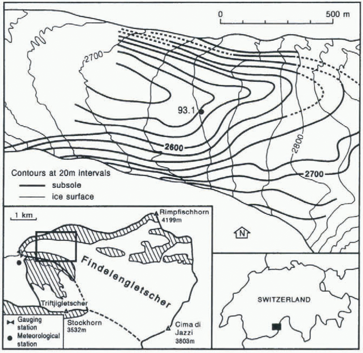
Map of the ablation area of Findelengletscher, showing the location of borehole 93.1 and contours of ice surface and subsole (after Süsstrunk, 1960; Iken and Bindschadler, 1986). Inset maps show the basin of Findelengletscher above the gauging station, and the location of the basin in the Pennine Alps, Switzerland.
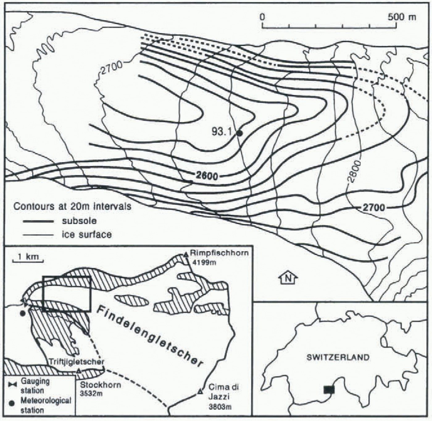
Only one of several boreholes drilled to the subsole earlier in the season, borehole 93.1, remained instrumented in September. It was located about 1.5 km from the glacier portal over a valley in the bed (Fig. 1). A Druck PTX530 pressure transmitter was suspended 66.2 m above the base of the 160 m deep hole, and hourly average water level was obtained from 10 minutely records. Hourly average air temperature and hourly totals of precipitation were recorded at the meteorological station close to the terminus of Findelengletscher (Fig. 1), until power failed on 24 September.
Samples of meltwater and suspended sediment, collected since May at least every 2 h, 24 h d−1, in the entrance to the adduction gallery by a Manning S4050 automatic pumping sampler, were processed as described by Collins (1989). Sediment dux was calculated as the product of suspended-sediment concentration and discharge until 1600 h on 22 September. The sampler was not reset at that time. A minimum estimate of the volume of sediment transported during the main part of the storm was derived from the dimensions of the length of the adduction gallery that became choked with sediment.
Changes In The Basal Drainage System Before The Storm, Inferred From Measurements Of Borehole Water Level And Discharge
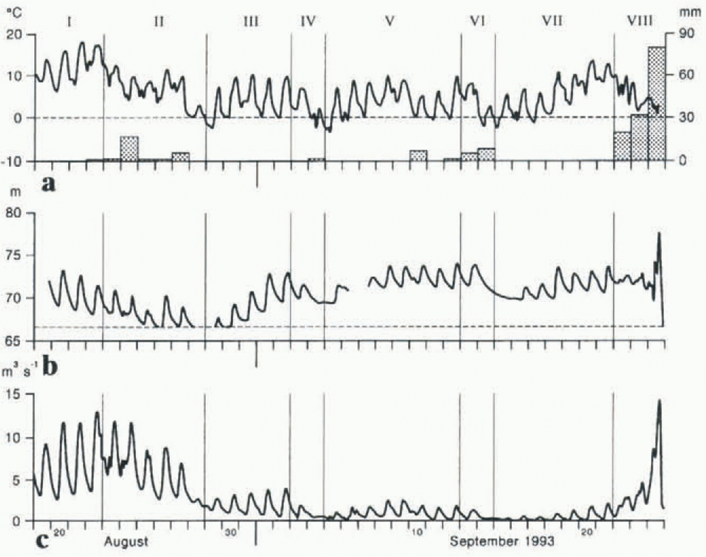
Discharge from and water storage within an alpine glacier should broadly follow the temporal pattern of meltwater input. During the period 19 August–21 September, discharge in the Findelenbach generally tracked air temperature, an indicator of the energy available for melting and hence of meltwater input (Fig. 2). From 22 August, the trend of runoff from Findelengletscher was downward, reflecting a period of generally reduced energy input, until a minimum discharge was reached on 15 September. Subsequently, air temperature increased, reaching 13.4°C on 20 September, a value last exceeded on 22 August. This episode culminated in the storm.
Water level in the borehole remained below the equivalent of ice overburden pressure (139 m) throughout. Water level ranged between about 65 and 75 m above the base of the hole until 24 September, suggesting that input discharge exceeded the capacity of the basal drainage network at some point downstream of the hole. Rhythmic diurnal variations of borehole water level were in phase with those of discharge. However, water-level and discharge responses to some of the individual meteorological episodes were divergent and not broadly parallel.
(a) Daily total precipitation and diurnal variation of air temperature at Findelengletscher, (b) water level in borehole 93.1 (solid) monitored by a pressure transducer suspended 66.2 m (pecked) above the base of the hole, and (c) discharge in the Findelenbach, 19 August–24 September 1993. The vertical bars separate hydrometeorological episodes (I–VIII) which influenced discharge and borehole water level.
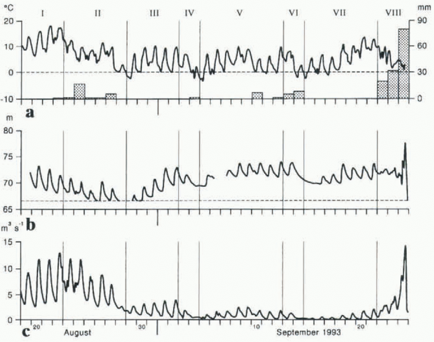
Seven meteorological episodes before the storm were delimited by air-temperature maxima and minima (Fig. 2). In episode I, although discharge tracked increasing air temperature from 19 to 22 August, borehole water level declined. This suggests that drainage-system capacity was enlarged and the volume of water ponded back in the glacier reduced. Falling temperatures in episode II, with snowfall at higher elevations on 27 August, reduced melt, and both discharge and borehole water level generally declined. During episode III, air temperature was generally cooler than in episodes I and II, and discharge remained below former levels. However, borehole water level increased, almost to that which accompanied temperatures 10°C higher on 20–21 August. The inference is that the dimensions of some subglacial pathways became reduced or that some blockage occurred in the system down-glacier from borehole 93.1, during the recession in episode II. Drainage continued to be restricted when meltwater input increased. After a second recession following snowfall on 4 September (episode IV), borehole water level rose to a higher elevation in episode V than was recorded in episode I, whereas discharge remained very low. Again, this suggests further closure of basal passageways or restriction to meltwater drainage, taking place over 2 or 3 d. Rainfall on 13 September and snow on 14 September led to a third period of recession flow (VI), in which borehole water level fell about 4 m in 3 d. Meltwater input to Findelengletscher under warmer conditions during episode VII restored borehole water level ahead of a small increase in discharge, but neither variable attained its value reached in episode V when energy availability and hence surface meltwater inputs were lower. The rate of input of meltwater may have been reduced at the start of episode VII as a result of the snowfall having increased albedo. Then, as melt rate increased, some meltwater may have remained ponded back within the glacier, but stored in reaches of the drainage system having little influence on the water level in borehole 93.1. Diurnal responses of both discharge and borehole water level to air-temperature fluctuations suggest that the borehole remained hydraulically connected to the drainage system throughout episodes I–VII.
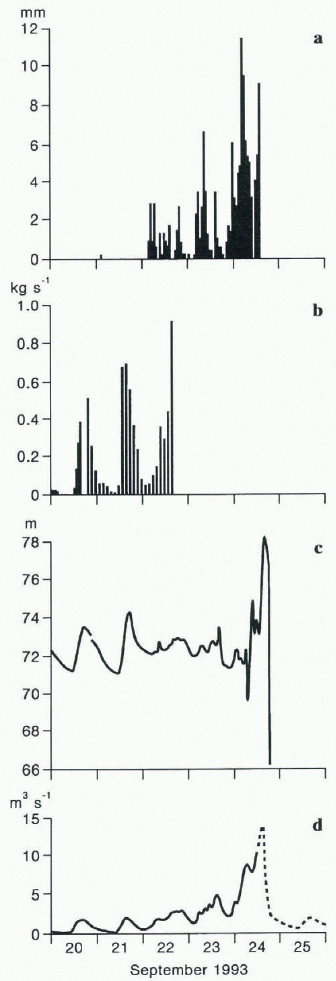
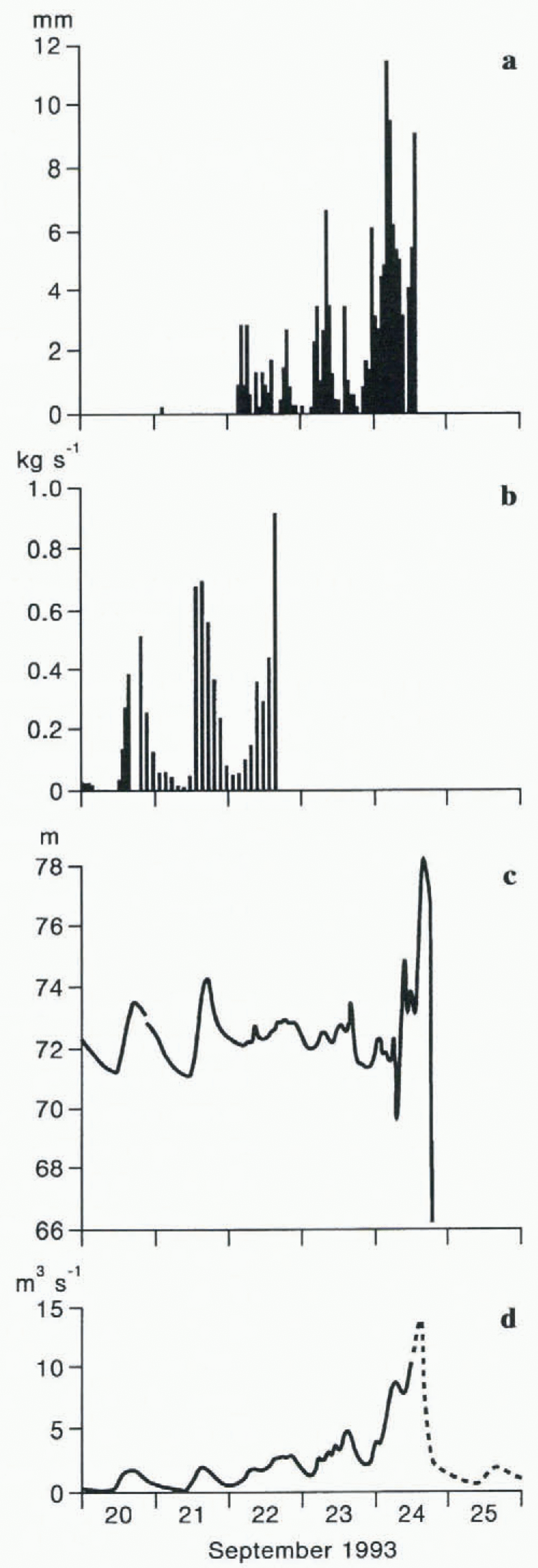
(a) Hourly total precipitation at Findelengletscher meteorological station, (b) hourly averages of sediment flux in the Findelenbach (to 22 September), (c) water level in borehole 93.1, and (d) discharge in the Findelenbach, 20–25 September 1993. The pecked line in (d) indicates interpolated data. See text for explanation.
Inferred Changes In The Basal Drainage System During The Storm
Precipitation, borehole water level and discharge
Pulses of intense rain contributed to total precipitation of 130 mm between 22 and 24 September and influenced the rising-limb hydrograph shape (Fig. 3). Water input to Findelengletscher was maximised, as warm air temperatures ensured that precipitation fell as rain at all elevations. The high, end-of-season, transient snowline exposed a large expanse of bare ice over which runoff was rapidly concentrated into channels and moulins. On 22 September, borehole water level and discharge increased in parallel, although the former under-performed as the latter exceeded maxima recorded the previous day. During 23 September, pulses in water level and discharge, accompanying bursts of intense rain, were superimposed on the usual diurnal patterns, until, from 1400 h, water level dropped 1.72 m in 3 h, including 1.1 m between 1500 and 1600 h. In that hour, discharge increased from 3.82 to 4.74 m3 s−1. Flow was sustained above 4.5 m3 s−1 until after 1700 h, receding to 3.64 m3 s−1 by 1830 h.
Pulsing continued on 24 September. Between 0400 and 0600 h, 20.8 mm of rain maintained borehole water level around 71.8 m, and increased discharge from 5.3 to 8.4 m3 s−1. Water level abruptly fell 1.75 m between 0600 and 0700 h, as discharge increased to 8.7 m3 s−1. By 0900 h, the water surface had risen rapidly by 4.58 m to 74.70 m, and discharge declined to 7.7 m3 s−1. Water level then fell lm suddenly before 1000 h, and an additional 0.46 m gently by 1400 h. Discharge declined during both the rise and 1 m fall in level, before increasing rapidly until 1400 h, when the record became unreliable. Borehole water level had risen to 78.08 m by 1430 h, before starling to drop, falling at an accelerating rate to 4.8 m h−1 between 1700 and 1800 h. The level then fell below the pressure transmitter, where it remained at least until observations ceased on 1 October. Input to the drainage system was reduced as the rain turned to snow at higher elevations towards the end of the storm. Snow fell over the entire basin on 27 September.
Sediment flux in the Findelenbach before and during the storm
During high flows in late August, average suspended-sediment flux in the Findelenbach was 529 t d−1. Between 1.1 and 32.5 t of suspended sediment were transported daily between 3 and 20 September, with 20.6 and 25.4 t on 21 and 22 September, respectively (Fig. 3). After the storm, the hydropower adduction galleries were found to have been choked by an estimated 104 t of fine and largely coarse debris. Maximum discharge during the storm exceeded the previous highest flow of the season by only about 2 m3 s−1. Some of the coarse material, including size fractions not mobilised in earlier high flows, could have been entrained from within the expanding drainage network. Total sediment flux, fine and coarse, during the storm was enormous by comparison with total loads transported by high-discharge events earlier in the summer, none of which left sediment deposited in the adduction galleries. The scale of sediment transport during the storm points to entrainment from a wide expanse of the glacier bed. In fact, the mass of deposited debris probably provides a considerable underestimate of the actual amount of suspended and bed load transported during the storm. Deposition of this debris caused the gauge to malfunction on the afternoon of 24 September. Some water (and sediment) flowed around the intake structure. After the storm, two small streams, which drain from the terminus of Findelengletscher over moraine to join the trunk Findelenbach above the gauge, were observed to have widened and incised their channels.
Water-pressure and basal drainage-system instability
Although some of the sediment that had choked the gauging station and adduction gallery by 1400 h on 24 September was derived from the proglacial area, most was flushed from beneath Findelengletscher. Water pressure continued to rise in borehole 93.1 during the infilling of the gauge, maximum borehole water level not being reached until 1430 h. Meltwater appears to have gained access to areas of subsole not recently integrated with flow, on which sediment had accumulated. The area occupied by flowing meltwater was enlarged. Existing conduits may have been widened along margins, entire channels displaced across the subsole, or new passageways opened. Whichever, discharge and sediment flux evidently increased before borehole water level started to fall. Water pressure could have continued to rise as a result of input from continuing high-intensity rain (9 mm between 1300 and 1400 h) exceeding discharge through the slackening constriction. Alternatively, initial drainage-system growth may have occurred in a branch of the network having no effect on borehole 93.1. By 1430 h, the basal drainage system had changed sufficiently for the restriction to meltwater flow downstream of borehole 93.1 to start to ease, and water pressure to fall. Borehole water level falling at an increasing rate during the afternoon of 24 September coupled with rapidly rising discharge is indicative of progressive channel growth by flowing water, which either melted ice through energy dissipation or eroded sediment at channel margins.
Three smaller rises and sudden drops in borehole water level occurred before the main event on 24 September. Although measurements were not taken, meltwater was observed to be highly turbid throughout the storm. This suggests much instability in the basal hydrological system. Again, it appears that runoff from the rain backed up in basal channels, increasing water pressure in the glacier. Suddenly, some water was released and pressure reduced. Substantial volumes of stored water escaped, about 6 × 10³ m3 in 3 h in the first of the three small events, for example. Ease of drainage was not maintained and pressure continued to rise after each fall, implying that a restriction to flow was partially removed, temporarily, before being reimposed.
Relationships Between Borehole Water Level And Water Pressure In Subglacial Channels
Diurnal variations of water level in borehole 93.1 in phase with those of portal discharge suggest that the hole may-have penetrated directly into a subglacial passageway, either a cavity or a conduit. Alternatively, the borehole may have been based on saturated basal sediment through which pressure waves were transmitted in response to water-pressure fluctuations in an adjacent channel. That borehole water level stood 65 m above the base of the hole indicates that water was probably backed up in the drainage system throughout the measurement period, until 24 September. For water level in a directly connected borehole not to have dropped substantially at times of low surface input and minimal discharge (e.g. 14–15 September), a constriction would have had to exist downstream to impede drainage through the system. Alternatively, the hole could have been located over a depression in the bed in which the water level would stand at least at the elevation of the sill of the basin. Subsole contours of Findelengletscher (Fig. 1) suggest no such depression. It is possible that the borehole intersected an englacial channel with fluctuating discharge. Water level in a borehole based in sediment would not fall far if channel cross-sectional areas were no longer filled with water, on account of the low permeability of subglacial sediment. Experimentally derived hydraulic conductivities of sediment layers beneath other glaciers lie between 10−7 and 10−9 m s−1(Fountain, 1994), and patches, or sheets, of such saturated till would not allow significant lateral movement of water.
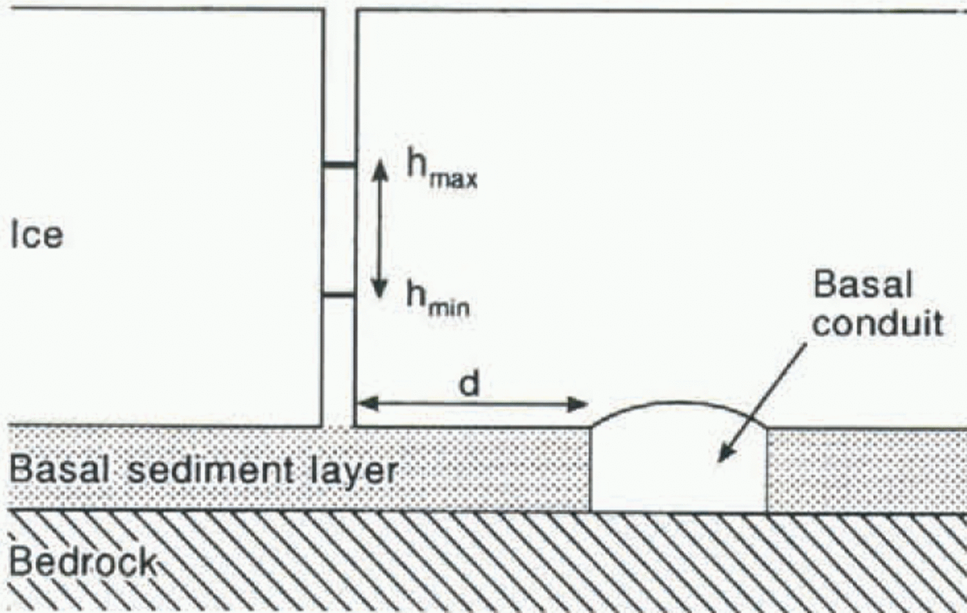
Schematic diagram of a basal sediment layer dissected by a subglacial conduit, showing a borehole at a distance d from the channel margin. Borehole water level h varies diurnally between daily maximum (hmax) and minimum (h min ) levels in response to water-pressure fluctuations in the conduit.
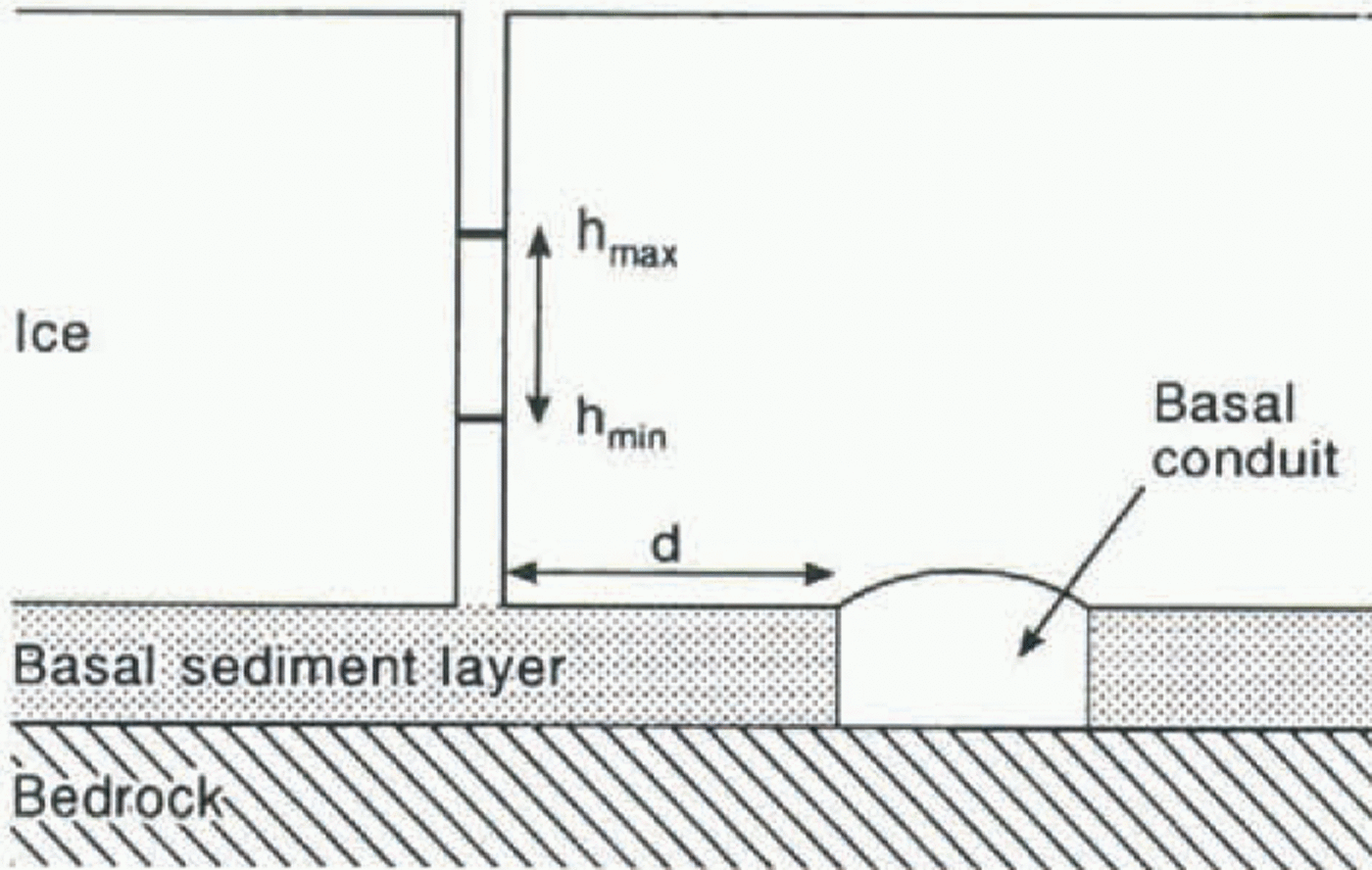
Assuming that the diurnal variation of water level in the borehole was induced by water pressure, not only would pressure waves be attenuated with distance (d) travelled through the sediment layer, but pressure extrema in the hole would also lag behind those in the channel. Possible conditions around the base of the borehole are indicated schematically in Figure 4. By analogy with heat conduction in a medium normal to a boundary plane which undergoes periodic variations in temperature (e.g. Ingersoll and others, 1948), the amplitude (A) of a pressure wave passing through basal sediment decreases away from the channel:

where A 0 is amplitude of water-pressure variation in the channel, w is the periodic frequency (2?/24 h), S s is the storage coefficient of the sediment layer (the discharge from a unit volume of sediment per unit decline in head (m−1) (Feeze and Cherry, 1979)) and K is hydraulic conductivity. From the observed diurnal range of borehole water level (h max – h min), = 2A), estimates of the distance of a borehole from a channel can be obtained, provided that the daily range of channel water pressure is known:

For borehole 93.1, channel water pressure in late summer is unlikely to be greater than ice overburden pressure (139 m) and may fall to atmospheric (0 m), prescribing the range 2A 0. Taking extreme values of hydraulic conductivity of subglacial sediment from Fountain (1994) and of storage coefficients (10−4 -10−7 m-1, after Freeze and Cherry (1979)), estimates of the distance the base of borehole 93.1 would be from a channel can be obtained using observed borehole water-level fluctuations with several possible ranges of channel water pressure (A/A 0). Lag times (?t) between the turning points of the curves of conduit water pressure and borehole water level increase with distance between the channel and borehole:

As decrease in the ratio A/A 0 also depends on distance travelled by the pressure wave, time lag is related to the damping of the water-pressure fluctuation

The range of possible channel water pressures was therefore constrained by observed time lags, assuming that maxima and minima of water-pressure variations in channels influencing the borehole were synchronous with those of portal discharge. However, timing of discharge peaks and troughs at the portal depends on arrival of water from all points on the glacier surface. Portal discharge will lag behind discharge through small channels near the borehole which convey only locally derived surface input.
Observed lags were usually ‹2 h, limiting possible values of the ratio A/A 0 to the range 0.59–1.00 (Equation (4)). For diffusivities (K/S s) between 10−5 and 10−2 m−2 s−1, within the above ranges of hydraulic conductivity and storage coefficients, the calculated maximum distance between the borehole and subglacial conduit is 8.8 m. For the borehole to be more distant, diffusivity must be large (88 m for K/S s = 1, the maximum diffusivity for the likely ranges of K and S s). The latter condition could indicate flow through small passageways such as links between cavities on an undeformable bed as well as flow through basal sediment.
Conclusion
Combined borehole water-level, portal-discharge and air-temperature records provide a useful qualitative indication of temporal changes in water storage in a glacier. They also provide information about the capacity of the drainage system to transfer water, effectively a measure of the dimensions of the “orifice” through which water drains from the glacier. An array of boreholes would have provided more information on water storage, and, for surface water input, measurements of ablation would have been preferred to the air-temperature surrogate.
Interpretation of borehole water levels is always difficult, and there is considerable uncertainty as to how water level in borehole 93.1 related to water pressure in subglacial channels. Water level in the borehole is unlikely to have been a direct piezometric measure of hydraulic conditions in a conduit, but may have reflected conditions in a network of small pipes. Water level may also have fluctuated as a result of transmission of pressure waves through saturated basal sediment, with suitable hydraulic properties, in response to pressure variations in a channel a few metres from the base of the borehole.
However, these combined measurements do demonstrate the link, suggested by Collins (1989), between water backing up and pressure rising in the basal drainage system with sudden, rapid spatial expansion of the drainage net and flushing of stored sediment during subglacial hydrological events. Evidently, such growth of the drainage system is followed by release of stored water and reduction of water pressure.
Periods of accelerated sliding of Findelengletscher are also often associated with high water pressures (Iken and Bindschadler, 1986), and basal drainage-network reorganisation and suspended-sediment flux events may well he coupled with glacier sliding. Displacement of drainage channels incised upwards into the ice, with respect to the subsole, through glacier movement, would allow meltwater access to sediment over areas of the bed not recently integrated with flow. Growth of basal cavities with rising water pressure and sliding could enlarge smaller passageways and allow discharge through the drainage system to start to increase.
Acknowledgements
The authors gratefully acknowledge the following assistance: Grande Dixence, S. A. for discharge and meteorological records from Findelengletscher and for logistical support through A. Kronig; members of the University of Manchester Alpine Glacier Project for help with fieldwork; and the U.K. Natural Environment Research Council for grant GR3/7265 (to D.N.C.). J. Barker of the Department of Geological Sciences, University College, London, helped to clarify concepts in groundwater flow, and A. Iken commented usefully ou a version of the manuscript.