

‘Where should I appear on the appointed day for the court case? Where can I find a baker, brickmaker, a horse, a seller of perfumes, or a sex worker for the night? Where can I find the enslaver of this person?’ Imagine a stranger arriving in Rome at the end of the first century BCE, perhaps a few days into their new life, overawed by the sheer size and depth of the city. These are all questions they might ask – questions which find answers in the epigraphic evidence surveyed in this article. But they are also questions which might have been answered by asking any passer-by in the street – a scenario that still happens today. Yet with the advent of Google Maps and other technologies, this social method of urban navigation is becoming less and less common.Footnote 1 Asking for directions today can have the effect of Othering oneself, exposing a person’s identity in terms of lower economic class, age, or foreignness. In ancient Rome, this article contends, this same relational act – of being directed and directing – was also more distinctive to particular non-dominant social groups, or ‘subalterns’ (sub-elite and non-elite, broadly construed) and their identity formation, than to dominant, elite groups, whose identity was less formed by quotidian urban navigation and less connected to local spatial knowledge of the city.Footnote 2
In contrast to modern cities, ancient Rome’s dense urban landscape lent itself to the formation of spatial identities precisely because Romans navigating the city did not have e-navigation, did not often use maps or have the benefits of a systematic grid or regularised street signs, and instead relied on social directions in tandem with unplanned visual cues taken from the urban environment to create ‘mental maps’ of the city – a process the urban planning theorist Kevin Lynch called ‘wayfinding’.Footnote 3 In Lynch’s theory, landmarks function as only one element within an ensemble of other tools available for wayfinding in the fabric of the modern city: ‘paths’, ‘edges’, ‘districts’, and ‘nodes’. Many of these elements can be mapped onto features of ancient Roman urbanism (see Table 1) and these different elements worked in tandem, often centring on a ‘path’ (e.g. a street), which would then enter a ‘district’ (e.g. a vicus, forum, regio) that was usually bounded by an ‘edge’ (e.g. city wall, Tiber river, hill escarpment) and structured around one or more ‘nodes’ (e.g. a city gate, major public space). Finally, ‘landmarks’ within the district would function at a more local level of direction. Even so, many Roman features which could fall into one Lynchian category, such as ‘paths’ (e.g. vici, viae), could also function as ‘landmarks’ in and of themselves. Indeed, the overlap of the city’s different elements is inevitable and integral to the complete image of the city, as Lynch emphasised.Footnote 4 That architecture students today are still taught Lynch’s basic framework attests to its staying power, supplemented, but not supplanted, by work in cognitive theory and computational modelling.Footnote 5
Lynch’s (1960) elements of wayfinding and potential equivalent Roman elements

More recently, Per Mollerup, complementing Lynch, has focused on deliberate aspects of the built environment, such as signage, which play a role in ‘wayshowing’ – auxiliaries to wayfinding proper; and yet, focused as he is on modern urban planning, his analysis devoted little attention to the type of social wayshowing which would have been far more important than the very few indications of written directions or signage we possess from the Roman world.Footnote 6 To be sure, there are examples of ad hoc signage in the Roman world, such as the terracotta plaques found on the facades of buildings at Ostia and Pompeii, some of which seem to motion the viewer in a certain direction.Footnote 7 Many of these plaques may have simply served, however, as mini-landmarks, guiding people to a destination, or providing confirmation of their arrival, ultimately occupying the space between a pre-existing, appropriated wayfinding landmark and an intentionally made wayshowing marker. Yet even with this visual aid, many wayfinders would have been primarily dependent on the oral or textual instructions given by a social wayshower.
Wayfinding theory, as this article proposes, can lay bare an underappreciated Roman spatial modality and forces us to reorient our approaches to the topography of Rome, away from cartography and towards hodological conceptions of the space of the urbs. While a small number of cartographic-style maps have been found in the Roman world, the average Roman did not consult, for example, the monumental Severan marble plan, known as the Forma Urbis, for their daily navigational needs in the city.Footnote 8 And yet cartography has been an overwhelming priority in the study of Roman topography: scholars cull references to the monuments and structures of the city from many different texts, both literary and documentary, and attempt to map them onto a modern, aerial map with the aid of other evidence, from archaeological remains to the Forma Urbis itself, ever since such cartographical milestones as the Nolli Map in 1748 and Lanciani’s publication of the Forma Urbis in 1901, largely based on the Nolli Map. Of course, the crowning achievements of these endeavours have been Steinby’s (1993–2000) magisterial edited multi-volume Lexicon Topographicum Urbis Romae, Carandini and Carafa’s (Reference Carandini and Carafa2012) Atlante di Roma antica, and the ongoing online GIS mapping project of SITAR (Sistema Informativo Territoriale Archeologico di Roma).
The cartographic compulsion which underlies these examples and most other previous scholarship on Roman topography has diverted our attention away from placing an equal or greater emphasis on how Romans – especially subaltern Romans – perceived and navigated their city’s topography, and how this navigational framework lent itself to processes of subaltern identity-making which actively appropriated the city’s topography. Modern cartographical representations of ancient Rome generally reproduce ancient conceptions of Rome’s space commissioned by elite Romans, such as the Forma Urbis, built into the bird’s eye and aerial, administrative views of the city available largely to that group and produced for specific reasons – ideological, cadastral, or otherwise.Footnote 9 Very few subalterns, perhaps only the enslaved members of households in domus atop the hills of Rome, might have had access to the perspective captured in Martial’s description of the stunning view from the house of the wealthy Julius Martialis on the Janiculum Hill, from which he could see the seven hills of the city and ‘all of Rome’ (totam … Romam).Footnote 10 Even more importantly, when the subaltern had access to this spatial perspective, it would have largely been beside the point of their quotidian spatial needs, for which the street view orientation of wayfinding was indispensable. Elites, as we will see, probably engaged in this practice far less frequently.
In reorienting the study of topography towards hodological, spatial navigation on the ground and its role in the formation of subaltern spatial identities, I propose that topography can join a larger movement which has percolated for decades, but is now starting to build more momentum in ancient history and classics – that is, the recovery of what Ranajit Guha, one of the founders of the Subaltern Studies Group (SSG), called the ‘small voice of history’.Footnote 11 In the terminology of the originator of the expression, the Marxist theorist Gramsci, the subaltern topography in this article refers to the non-dominant, non-hegemonic understandings of Rome’s topography, and what Gramsci called the many variations of ‘common sense’ (senso comune) of the subaltern person, here manifested in the many topographies which are not, and cannot be, plotted onto a modern map of ancient Rome.Footnote 12 Marín-Aguilera has helpfully distilled senso comune from an archaeological viewpoint:
senso comune refers to the beliefs and opinions of the masses that create a practical consciousness to confront their everyday life successfully … These worldviews in which common sense is built upon are essential for every human being to understand reality, to interpret it and to act effectively within it, but they are also contradictory and uncritical. Importantly, worldviews are modes of and for reality and thus they are different from one group to another, and that includes different segments within the same society …Footnote 13
Wayfinding can be conceived as a spatial senso comune, inasmuch as Lynch also recognised that navigation through the urban landscape has a social role to play as a common reference point for a city’s inhabitants: ‘The named environment, familiar to all, furnishes material for common memories and symbols which bind the group together and allow them to communicate with one another. The landscape serves as a vast mnemonic system for the retention of group history and ideals.’Footnote 14 We might, then, be tempted to read Lynch’s schema onto ancient Rome, in terms of collective or cultural memory-making for the Roman community as a whole – elite and subaltern alike – and yet, as much as this might appear to cohere with certain elements of the urban fabric, this shared ‘named environment’ could operate differently for very disparate groups, not least hegemonic and non-hegemonic groups, but even among different subalterns. Just as Gramsci’s senso comune varied among subalterns, Patricia Hill Collins’s work on ‘matrices of domination’ also forces us to recognise that oppression works in intersectional ways, whereby there is rarely any pure ‘victim’ or ‘oppressor’ in a society; rather, subalterns can and will oppress each other, and as such, experiences of space will have differed from subaltern to subaltern.Footnote 15 Here, therefore, my emphasis falls upon how the named environment of Rome could accommodate, and was appropriated by, subaltern social groups and individuals throughout its long history, ranging from a certain individual’s idiosyncratic, hyper-local connection to a landmark to the relationships between specific monuments or districts and particular professions and trades.
Previous studies on Roman wayfinding thus far have either been small in nature, focused primarily on the literary evidence, or have not engaged with the framework of Lynch in a meaningful way.Footnote 16 When scholars do apply Lynch’s theory in an extended manner, it is not usually from an emic, experience-near perspective; instead, the modern urban planner or architect travels back in time and, more often than not, adopts an elite-centric lens that is not borne out on the ground. In this vein, Favro’s study of the urban image of Augustan Rome represents the most sustained engagement with Lynch in an ancient urban context, devoting a significant part of a chapter to pressing Augustus’ urban interventions and building programme into Lynch’s framework, with a view to emphasising the high ‘imageability’ of Augustan Rome – that is, as a readable city with highly distinctive (architectural) features, conducive to wayfinding.Footnote 17 While Favro acknowledges that she cannot interview the inhabitants of Augustan Rome – unlike Lynch in 1950s Boston, Jersey City, and Los Angeles – she still claims that ‘analyzing the tangible evidence for Lynchian elements within a Roman city reveals information about the urban perceptions of ancient residents and patrons’, wherein Augustus is ultimately cast as a Lynchian urban-planner and his fellow citizens as passive recipients of his urban revolution.Footnote 18 The problem with Favro’s assertion, however, is at once methodological and evidentiary. On the one hand, she assumes that Augustus was thinking in proto-Lynchian terms, or something resembling it, and that the sheer impact of his building programme would have unavoidably shaped the populace’s perception of the city and its space. No doubt it did the latter, but her evidence is literary and she essentially erases the subaltern populace’s response to Augustus’ urban interventions, all the while attributing primacy of agency to Augustus in re-determining the imageable aspects of the pre-existing republican city. Indeed, more recent work on representations of urban space in the Roman empire, primarily on souvenirs, by citing Favro’s approach, has opened up a further gap between the ‘imageability’ of the city – its represented form in certain media – and how the elements of wayfinding actually operated on the streets of Roman cities.Footnote 19 As a result, the ‘image’ of the Roman city has been increasingly divorced from how its inhabitants experienced, perceived, navigated, and shaped it.
In what follows, then, my approach turns away from the hegemonic and omniscient lens of previous studies and asks that we see Roman urbanscapes from below, wherein their spatiality was shaped by the subaltern requirements of functional navigation and through place-making connected to the construction of professional identities. Lynch himself, informed albeit erroneously by the work of Léon Homo, had already discerned the very intimate level on which wayfinding directions, or ‘addresses’, as he calls them, functioned in ancient Rome ‘solely by small defined districts’, rather than with reference to Augustan structural irruptions in the cityscape or other imperial architectural programmes.Footnote 20 To this purpose, I train my focus on the broader articulation and practice of wayfinding by the primarily subaltern, everyday living inhabitants of Roman urban environments, as illustrated by a variety of epigraphic, documentary evidence – graffiti, brickstamps, wax tablets, enslaving collars, epitaphs, and more – from Rome and the bay of Naples. This evidence allows us to discern the wide range of functional contexts in which wayfinding would have been essential to urban life in many Roman cities, from slavery and court cases to brickmaking workshops and ritual cursing, but especially in Rome and its expansive, dense, urban environment. The majority of this evidence is highly textual in nature, often offering very specific wayfinding directions, which might suggest that its audiences were literate to a fair degree, some more than others, and possessed different degrees and types of ‘functional literacies’.Footnote 21 As we will see, the reader of the graffiti and painted notices on the tombs and walls of Pompeii could differ from those who could recognise a toponym on a simple epitaph, or, further still, those who could decode the text-image rebus on a brickstamp. Many of these readers would have overlapped, too, however. Some of these texts also had non-readers – inasmuch as the curse tablet was only meant for divine eyes, while the wax tablets recording locations for court appearances were kept as records, not as reminders or guides for the parties involved, who instead probably had to remember these directions. Nonetheless, the written wayfinding sources considered here merely represent the textualisation of what would have been a primarily oral phenomenon of wayshowers providing directions.
My argument makes no claims to representing exclusively subaltern experiences of wayfinding, nor does it propose that wayfinding was solely a subaltern spatial modality, but it does assert that wayfinding had an outsized role in the subaltern’s quotidian spatial modality in comparison to the elite, even as the components of this modality would have varied within the senso comune of the subalterns of Rome themselves. This role is also illustrated in the translation of functional wayfinding directions into the toponyms featured in funerary inscriptions commemorating members of Rome’s professional and working classes. Taken holistically, this diverse evidence underscores how Rome’s urban sprawl and unparalleled scale – from the late first century BCE to the fourth century CE – in the Italian peninsula and Mediterranean more widely, meant that wayfinding became an indispensable spatial modality for the inhabitants of the urbs, not least for the subalterns among them.
The Functional Contexts Of Wayfinding
As noted earlier, unlike today, in ancient Rome, asking for directions would have been commonplace, but like today, that act may have been predicated on certain hierarchies of status and Roman matrices of domination that underlay quotidian life in the city. We find this intersection of status and wayfinding play out in comic fashion in the most well-known and oft-cited example of verbal direction, or social wayshowing, in Terence’s comedy Adelphoe (160 BCE), when the senex Demea is directed by the enslaved character, Syrus, how to find his enslaver, Demea’s brother, Micio:
Demea: Tell me the place, then.
Syrus: You know the portico down that way (pointing) by the market?
Dem: Of course I know it.
Syr: Go past it straight up the street. When you get to the top, there’s a downhill slope in front of you; run down there. Then there’s a shrine on this side (pointing) and not far away there’s an alley.
Dem: Which one?
Syr: The one by the large fig tree.
Dem: I know it.
Syr: Proceed down this.
Dem: But there’s no through way.
Syr: Of course not. Blast! You must think I’ve lost my senses! My mistake. Go back to the portico. In fact this is a much shorter route and there’s less chance of losing your way. You know the house of that wealthy Cratinus?
Dem: Yes.
Syr: When you’ve passed this, turn left, go straight down the street, and, when you get to the temple of Diana, go right. Before you get to the city gate, right by the pond, there’s a bakery, and facing that a workshop. That’s where he is.Footnote 22
Now, if we look closely at the Latin, the passage is littered with deictics, adverbs, and prepositions – the language of navigation and direction. The intricacy of the itinerary and the sheer number of landmarks that Syrus entrusts to the memory of the hapless Demea present the audience with a dizzying array of topographical signposts. We conceivably encounter all of Lynch’s elements of wayfinding in this single passage: discrete ‘landmarks’ abound (portico, market, shrine, fig tree, house of Cratinus, temple of Diana, pond, bakery), even as we encounter a few ‘paths’ (street, downward slope, alley, portico), one ‘node’ (city gate), and a dead-end or ‘edge’ (the alley). All told, Syrus rattles off thirteen topographical features to guide, or rather comically misguide, Demea, to his brother, Micio. When Syrus has to begin anew with his directions – ‘my mistake’ (erravi) – no doubt there is a pun here on the verb errare, as Sheira Cohen has pointed out: he has both ‘made a mistake’ and he has ‘wandered’ off course in his mind, demonstrating that the act of urban wayfinding was dependent on the cognition of the guide – the wayshower – too.Footnote 23 We must also remember that here we are in the Rome of 160 BCE. Perhaps there was a joke to be had in the ridiculous length of the directions in and of themselves, notwithstanding that they are akin in length and detail to those given by a denizen of twentieth-century Jersey City in one of the interviews Lynch conducted for his research.Footnote 24 One also wonders if Terence’s joke would have landed in the same way in the Rome of 200 or 300 years later, when the city had expanded well beyond the limits of the Republican walls and was even more of a rabbit’s warren of crowded private alleys, in addition to the main, publicly maintained streets.Footnote 25
Despite all of the questions it raises, Terence’s text still opens an important window onto the elements of Roman wayfinding and its most basic context of locating a particular person – unlike many other literary texts, which may suggest a familiarity with the praxis of wayfinding, but no practical interest in it beyond the possibilities it could offer as a literary conceit or historiographical device.Footnote 26 In light of Richlin’s recent work on Roman comedy as slave theatre and the subalternity of its playwrights, including Terence, the voice of the subaltern might be refracted through the enslaved character of Syrus, and their particular understanding, perception, and experience of Rome’s urban topography might be heard within the literary artefact of the text.Footnote 27 After all, enslavers also needed to find their way around the city – if only with the aid of enslaved people like Syrus, or an enslaved lantern bearer, as was sometimes depicted in terracotta figurines from the wider Hellenistic world (Figure 1); but, crucially, these elites rarely mention their auxiliaries. To be sure, Demea’s responses imply some pre-existing knowledge of the city and cognitive assent around Syrus’ directions (quidni noverim … novi … scio), even if the former’s knowledge of the city is not inconsiderable – he knows about the choice between two alleys and a no-through way. But the fact that Demea comes to the enslaved Syrus for such directions, deferring to his knowledge, suggests that a Roman audience would have understood that an enslaved person would have usually been in a better position to navigate the city than an elite person like Demea.
Terracotta lamp depicting a (presumably free) reveller being led home by an enslaved African boy with a lamp. Second–first century BCE. Thebes, Egypt. British Museum, inv. EA3756. Photo used with permission of the Trustees of the British Museum.

Moreover, as soon as we encounter the non-literary, documentary evidence for the functional contexts of wayfinding among sub-elites and non-elites, we are forced to question who truly experienced wayfinding on a daily basis, not least when the subaltern figure of someone like the enslaved Syrus was more likely than not the person bearing a senator’s litter from point A to B in the city. Indeed, as we progress through these texts and contexts, it is important to bear in mind that the act of ‘finding’ a person, place, or thing, was very often never a task which elites would have undertaken themselves personally, but rather delegated to others, most likely members of their enslaved or freed familia, to perform on their behalf.
Finding And Directing (Novellia) Primigenia
If we return, then, to the questions a hypothetical newcomer to the city might have asked, we find answers in the epigraphic evidence which point to a host of functional contexts wherein wayfinding came into play, including explicitly subaltern interactions in subaltern spaces. The type of wayfinding directions, or wayshowing, that Syrus offered the elite figure of Demea in Terence’s comedy usually do not survive from the Roman world. Yet the exceptional preservation context of Pompeii and other cities in the Bay of Naples has meant that graffiti from these urban contexts offer glimpses of this verbal practice, textualised, on the city’s walls in terms of a certain woman: Novellia Primigenia of Nuceria. Primigenia was not your typical business woman, and she may have been an actress or a high-class sex worker; but she may also be several women – the name Primigenia appears over twenty times at Pompeii – who have been conflated by scholars into one persona.Footnote 28 We do know that her name, or variations thereof, is attested in ‘I was here with so and so’ graffiti in Pompeii several times with various masculine names.Footnote 29 Regardless of her exact trade, she was highly sought out. Interesting for our purposes, a graffito from Tomb 23 of the Porta Nocera necropolis and a graffito from the House of the Menander at Pompeii, both refer to her:
Greetings to Primigenia of Nuceria. Would that I were the gemstone [of a signet ring] if only for one single hour, so that when you moisten it with your lips to seal a letter, I can give you all the kisses I have pressed upon it.Footnote 30
At Nuceria, near the Roman gate in the neighborhood/street of Venus, you will find Novellia Primigenia.Footnote 31
The first graffito not only took advantage of the fact that the necropolis outside a porta often acted as a site of textual solicitation – among the tombs whose epitaphs also exhorted passersby – but also its location on the road leading to Primigenia’s ostensible home in Nuceria, about nine miles away from Pompeii. The second graffito advises others from within Pompeii, in a notably marginalised space – the service quarters of the house – that they could find her at the Porta Romana in the vicus Venerius in Nuceria, perhaps acting as an advertisement on Primigenia’s behalf. The porta Romana thus becomes one of the nodal directives and entry points for a stranger to Nuceria, but also the location of Primigenia, or at the very least the vicus Venerius seems to have been near that particular gate. In a further twist, it would seem that the same (or another) Primigenia was herself solicited to come to Puteoli by an enslaved individual named Hermeros, who left a graffito at the Suburban Baths at Herculaneum that gives an address, and even an interlocutor, who might direct her to Hermeros:
Hermeros to his domina Primigenia: come to Puteoli in the Tyanian street and ask Messius, the money lender, for Hermeros [the enslaved person] of Phoebus.Footnote 32
This graffito was situated on an external wall near the entrance to the baths, in an area of high traffic, as evidenced by several other graffiti on the same wall, including a pictorial graffito of a caricatured wreathed head in profile which intervenes upon Hermeros’ own scratched missive. Importantly, several of the graffiti on the wall record the sexual activity of other men at the baths, and many of them were enslaved or potentially enslaved.Footnote 33 Both the space where this set of wayfinding directions was inscribed, like the service quarters of the House of the Menander, or even the tombscape of the Porta Nocera, and the medium of the graffito itself, are therefore marked for a seemingly subaltern audience. That Hermeros’ wayshowing missive was publicly viewable, scratched in alongside graffiti from other enslaved individuals, suggests it could well have been entirely aspirational, too – knowing full well that Primigenia might never read it, but his audience of enslaved persons lingering at the wall would. Moreover, even as the graffiti do assume a certain level of literacy among their readership – an issue to which I will return – if a local elite had wished to ‘find’ Primigenia, their enslaved staff would have probably done so, whether by asking around, or having encountered a graffito like Hermeros’.
Lost And Found Property
By the same token as Hermeros’ directions, though within a different matrix of domination, subalterns became implicated in the act of ‘finding’ other subalterns through the question of how to return lost human property, that is, an apprehended formerly enslaved person, or freedom seeker, to their enslaver. The late Roman enslaving collars, studied by Julia Hillner and Jennifer Trimble most recently, point to the urban phenomenon of slavery, but also how the potential recovery of an enslaved person sometimes meant providing textualised wayfinding directions to the finder.Footnote 34 A sampling of these collars demonstrates that the enslavers of these people are usually named, but for the imagined reader the address was presumably the more useful initial piece of information. One of the collars with the most specific information directs the finder first to the Aventine hill, probably an implicit reference to the official thirteenth region of Rome, and then to the house of a certain Potitus, ‘at the Decian baths’, perhaps a locale surrounding those baths.Footnote 35 The invocation of Rome’s fourteen administrative regions in identifying one’s spatial identity in the city seems to have been fairly limited to these collars and other late Roman epigraphic texts, signalling a broad district.Footnote 36 The actual named Decian baths may have done double work in naming the enslaver’s name and the enslaved person’s designated place of work. Nevertheless, several of the enslaving collars begin their directions with the region, followed by a specific landmark to indicate a more precise address, perhaps moving from a Lynchian ‘district’ to a more specific ‘landmark’ within it.Footnote 37 Across these examples, there is no exact uniformity in the directions given, but they all manage to specify at least one landmark.
Of course, we also have enslaving collars which detail no such directions, or only provide the name of the town. Presumably there were other factors at work in these cases: the distinctive physical traits of the enslaved person may have made them well known or recognisable enough, or the size or isolation of the town was such that it would have been easy enough to find the enslaver by word of mouth – through social direction alone.Footnote 38 In any case, what these collars reveal is how the ‘geography of containment’ they participate in, as invoked by Trimble, relied upon the community’s shared understanding of urban navigation vis-à-vis wayfinding.Footnote 39 In this vein, another example specifically designates the city wall of Rome as the boundary past which a certain enslaved person, Asellus, should not pass:
I, Asellus, slave of Praiectus, official of the prefect of the grain supply, have gone outside the wall. Hold me because I have fled; lead me back to the barbers at the temple of Flora.Footnote 40
Here, then, an element of wayfinding – the Lynchian ‘edge’ of a city wall – is deployed to construct this geography of containment, just as the would-be finder of Asellus is given a specific address for return to a third party, presumably in some type of mutual arrangement between Praiectus and the barbers at the temple. Indeed, Asellus may well have been hired out to the barbers at the temple of Flora and, in general, many of the people around whose necks these collars were fastened were enslaved to members of the professional classes, as Hillner’s analysis has shown. The collars usually referred to locations of businesses or tradespeople – the type of men and women who, as we will see in the next section, in death also advertised their place of work in a similar manner with respect to their location.Footnote 41 Crucially then, the enslaving collars remind us that as much as wayfinding was a navigational modality in use by sub-elites and non-elites, by the free, freed, and enslaved alike, it was just as enmeshed as any other Roman practice in a matrix of domination, so that it was very possible that the directions on a collar could be leveraged by an elite enslaver or by one (enslaving) subaltern against another (enslaved). Here, the enslaving collar, while ventriloquising the enslaved, adopts a textualised wayshowing apparatus that also assumed some functional literacy on the part of its audience – again a certain segment of subalterns, such as slave catchers (fugitivarii), or those who informed them – whereby the text could have acted as a check upon any wayfinding information relayed (voluntarily or by torture) or refused by the recaptured person.Footnote 42
However much that wayfinding was crucial to the practicable and ideological creation of matrices of domination in contexts of slavery, the enslaving collars should also be situated within the more general category of ‘lost property’. One painted notice from Pompeii advertises the finding of a horse and details how its rightful owner can come to claim it – that is, the rightful owner could venture just outside Pompeii, on the near side of the bridge at the Mamian estate:
If anyone has lost a mare weighed down with saddle bags/baskets, on 25 August November, then let him come to Quintus Decius Hilarus, freedman of Quintus, or Lucius Decius Amphionis, freedman of Lucius, this side of the bridge over the Sarno river at the Mamian estate.Footnote 43
This notice was actually painted in at least two locations, on two different tombs in different sectors of the Porta Nocera necropolis, and so it is likely that there were further copies posted throughout the town or other gates of the town. As we will see, the role of the gate (porta) as an important ‘node’ for incoming and outgoing travellers to the city may have attracted these kinds of wayfinding notices.Footnote 44 The two Decii also notably mark themselves out, including their status as freedmen, perhaps in an effort to make it clear who should receive any finder’s reward or to suggest that should any future legal claim be made upon the horse – a horse they may have intended to claim as their own through usucapio – they had in fact attempted to find the owner with all due diligence.Footnote 45 We therefore need to imagine that in a place like Rome the walls of the city were even more littered with these types of painted lost property notices, again assuming a certain type of literacy of their primary readers, but also a readership that had the time and attention to read them – people like the mule-drivers and merchants whose traffic wore ruts into the streets of Pompeii.
In another genre of writing that often concerns the attempted recuperation of lost property – the curse tablet – we also encounter a unique instance of wayfinding directions being offered, presumably, to the gods. In one late Roman curse tablet recovered from Rome, an aggrieved person curses a certain baker Praeseticius, who we are told ‘lives in the ninth region where he is seen carrying out his trade’.Footnote 46 By the fourth century CE, if we can trust the Regionary Catalogues, there were at least twenty bakeries in this official administrative unit, regio IX, and hundreds more in the city at large, so that specifying the name and regio may have seemed necessary to the curser to ensure that the right person was being cursed.Footnote 47 Yet inclusion of the regio may well have been a sarcastic reference to the rare, but attested, reputational claims some people sometimes made in their epitaphs to having been the ‘best’ of a profession in a given regio of Rome, such as Valeria Verecunda, who was noted as being the ‘best midwife in her Region’ (iatromeae | regionis suae primae).Footnote 48 More generally, the rarity of references to the regiones, apart from the late Roman enslaving collars, may suggest the unhelpfulness of this spatial unit for wayfinding, as its vast expanse stretched the notional limits of the Lynchian ‘district’ for any functional navigation around the city.Footnote 49 On the other hand, Goodman has shown how, in the third century CE, the regiones seem to have become the primary administrative unit for the state distribution of the bread dole through bakeries in each region, and as such, bakers’ spatial identities may have become tied to this larger spatial unit.Footnote 50 In later Rome, then, the fourteen Regions may have become a more salient wayfinding element than they previously were, not least because they became central to quotidian, subaltern subsistence. Notwithstanding either explanation, evidently the curser of Praeseticius thought the locative detail of the regio was required for the curse to be successfully enacted by the divine “reader”; and while this type of topographical detail is otherwise unattested in the corpus of curse tablets, it may point to the ways in which the commonality of wayfinding as a primarily subaltern spatial modus operandi could see it bleed into other aspects of daily life at Rome.
Court Dates And Places
Just as wayfinding was imbricated in Rome’s systems of power and property – in its material matrices of domination – it also served the legal institutions which enforced them by creating carefully choreographed and curated spaces of justice, often involving cases about said lost property. Moving, then, to another question posed at the outset: in a vadimonium – the written legal agreement to meet at a certain place on an appointed day and time, for legal proceedings at the praetor’s tribunal – we find that here too a knowledge of landmarks, sometimes quite fine-grained, was not only assumed, but required of litigants.Footnote 51 The wax tablet archive of the Sulpicii, discovered just outside Pompeii, offers us one trove of references to these appointed meeting places, primarily in Rome and Puteoli, but also in one case at Capua, where the meeting point was set at the town’s basilica.Footnote 52 In some cases, certain landmarks seem to have been more popular than others, and as Bablitz and Metzger have suggested, these may have been chosen so as to control and funnel the crowds to certain areas while waiting to be heard by the praetor’s tribunal.Footnote 53 At Puteoli, the Hordionian altar of Augustus in the forum was the most popular landmark named – specifically in front of the altar, ante. Footnote 54 The archive also provides even more specific meeting points in Rome within the forum of Augustus, such as one document – a testatio sistendi – verifying fulfilment of the terms of a vadimonium, wherein one of the accused had been required to meet in front of a statue of Gracchus at the fourth column near the steps in the forum of Augustus at Rome.Footnote 55 Such specificity may have been due to the fact of there being more than one statue of a famous Gracchus – father and two sons – in the forum of Augustus, and to an outsider, travelling to Rome for a specific hearing, as most of these documents attest, these directions may have been confusing.Footnote 56 But what we should take from this is the specificity required of wayfinding and how it played a significant role in an important aspect of Roman life that was no less entangled in its matrices of power, since showing up at the right time and place at Rome could possibly determine one’s legal status – in cases of disputed freedom or infamia, which were usually referred from local courts, such as Puteoli or Capua, to Rome.Footnote 57 Elites would have also needed to wayfind to their appointed place on a certain day and time, but for very few of them would the stakes have been as high, and it was probably their subaltern attendants who led the way or relied on the wayshowing of others to arrive on time at their destination.
Finding And Advertising Business
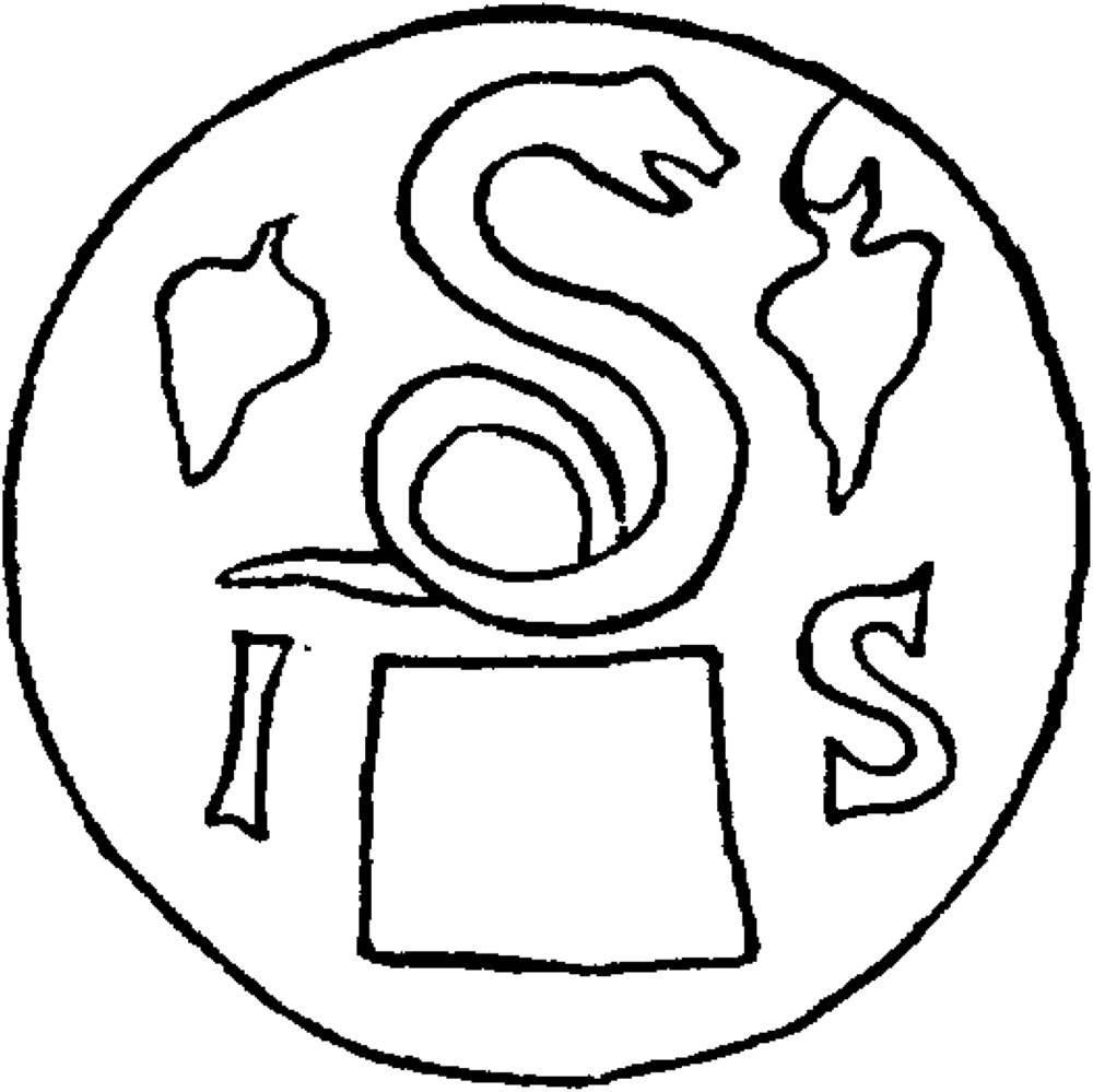
Finally, if we turn to businesses, these could evidently become elements of wayfinding themselves, as landmarks – so much is already clear from Syrus’ directions in Terence, the enslaving collars, and Praeseticius’ bakery. But places of business could also draw upon elements of the named environment creatively to guide potential customers to them, too. To consider just one trade and the way it could build its location into its own products, let us turn to the brickmakers and the stamps they impressed on their handiwork. These ubiquitous stamps, when they featured signa or visual symbols, rather than simply the name of the workshop or its proprietor, provided a ready-made way to find the workshop, should a prospective client like what they saw. Thus, as John Bodel has shown, we have brickstamps from the beginning of the second century CE attesting to a workshop near the temple of Isis or in the eponymous region, and some of these build allusions to Isis into their stamp design (Figure 2).Footnote 58 Even more intriguing is the brickstamp of a Lucius Atinius, which locates his workshop near the temple of Mercury through a text-image rebus design (Figure 3).Footnote 59 As Bodel explains:
[the stamp] shows his name written out with the first two letters in ligature, beneath a large palm frond that arcs from a bust of Mercury at the left to the epithet Felice(m) (‘Fortunate’) at the right, thus bridging the separate modalities of signum and text. Together they create a synthetic message in which the image is to be read as a rebus to indicate the name of the deity. The positioning of the manufacturer’s name, Atinius, near, in fact sheltered beneath, a palm, replicates the locational force of the preposition ad (‘near’) in the name of the brickyards.Footnote 60
Stamp of the figlinae ab Isis with line drawing of Isiac signum, from Ostia. CIL 15, S. 58. Line drawing after Bloch (Reference Bloch1947) 20.

Stamp of L. Atinius of the figlinae ad Mercurium Felicem with line drawing of the rebus speaking sign. CIL 15, S. 86. Line drawing after Bosio, in Morpurgo and Bosio (Reference Morpurgo and Bosio1931) 291, fig. 47.

We can also conjecture further that the palm tree itself may well be a further locative clue, since we know that trees could accrue the status of landmarks in Rome, too. We saw this in Syrus’ mention of the fig tree in Terence’s comedy, but 250 years later, other examples pop up: the poet Martial could claim that he lived near a pear tree, while at roughly the same time, the emperor Domitian was supposedly born in a region named after a pomegranate tree and, finally, we know from one epitaph and a lead-token (tessera) depicting a tree with the legend ad nucem and a chestnut on its reverse, that a famous chestnut tree may have stood in northern Rome and held locative significance.Footnote 61 As they withered away with age, these trees may have been continuously replanted, as we know from some other examples, so that their role as living landmarks was maintained, or, if not, their past prominence in an urban space may have seen them ossified into toponyms.Footnote 62 In either case, the brickstamp of Lucius Atinius locates his workshop through a constellation of visual and textual wayfinding elements, positioned as it was between tree and temple. Above all, it distils how text and image could operate in tandem to create an ingenious advertisement – one that was perhaps more accessible than text alone to audiences with varying levels and types of literacy. By intuitively prompting its audience to decode its text-image puzzle, it also revealed an itinerary to guide potential consumers to the business. Even so, behind every brick in the wall, we must not forget the enslaved individuals who worked in the thousands of businesses in the city of Rome and how the very same wayfinding directions might be weaponised against them should they unsuccessfully seek freedom.
The functional contexts of wayfinding, as canvassed here, merely touch the surface of what would have been myriad in the city of Rome and other urban contexts, such as Pompeii. Nevertheless, as a slice of life, the utilitarian nature of these contexts, texts, and their potential audiences indicates that, for the most part, subaltern inhabitants of, and visitors to, the urbs would have been the primary users of wayfinding or wayshowers, especially once they ventured outside their known spatial zone or an outsider entered their field of reference, whether it be a vicus, regio, or an entire urban centre itself. Each context has demonstrated that the act of wayfinding was subject to its own particular matrices of domination, from the recuperation of ‘lost property’ to spatially choreographing the legal processes that might see the ‘lost’ status of that property litigated. Wayfinding was clearly an integral, yet far from innocent, key to living a navigable life in Rome’s named urban environment, but as the next section demonstrates, the location of one’s business or trade – the destination point of so many of the wayfinding directions surveyed thus far – became the most important instantiation of wayfinding in the world of the dead subaltern.
Locating Your Professional Life In Death
Just as the enslaving collars and brickstamps, among other media, deployed the apparatus of wayfinding to lead people to places of business, the commemoration of subaltern people in their epitaphs at death sometimes included the location of their trade or business while living, in this way memorialising their labour-based topographical identity alongside other aspects, such as their gender, filiation, legal status (freeborn, freed, enslaved), citizenship, occupation, and social relations. If we move from the quotidian documentary sources attesting to wayfinding among the living to this corpus of sepulchral inscriptions, we find a similar attention to features of the named environment at Rome that could be understood through one or multiple elements of Lynchian wayfinding.
A corpus of some 160 funerary inscriptions from Rome – and this is probably not exhaustive – reveals that 110 unique toponyms were included in sepulchral inscriptions.Footnote 63 Of the 110 toponyms identified in the corpus, 60 are only attested in one inscription each, pointing to the high level of heterogeneity among the locations deemed worthy of commemoration.Footnote 64 At the same time, there are a small minority of places which predictably lay claim to a significant share of the commemorative landscape. In particular, the Sacra Via dominates the corpus, with at least 30 inscriptions including it as a location of a business. The Sacra Via was prime real estate, as is well known, and the majority of professions attested for it were high-end, that is, sellers of pearls, goldsmiths, and so forth. In what may have been a self-perpetuating situation, the street probably attained significance not only from its role as a processional route, but because it continued to attract businesses focused on luxury wares.Footnote 65 Yet the Sacra Via was probably more than a ‘path’ in the Lynchian sense, as it seems to cut across the categories of path, district, and landmark, functioning as one urban feature all at once. Such was the prestige and imageability of the street within the urbs that we even have inscriptions and epitaphs from outside Rome and from living inscribers commemorating the fact that the person worked on the street. One example – though not an epitaph itself – comes from a remarkable dedicatory inscription dated to 1 October 35 BCE and written by a subaltern person passing through Ithaca, Greece, who had visited a sacred cave there. Here a certain Epaphroditus commemorated his presence at the place, but also his profession as a perfume seller and the prime location of the Sacra Via in Rome, even as he was also the slave of a certain Novius.Footnote 66 Beyond the Sacra Via, the number of topographical references to Rome in epitaphs from outside the city are few and far between, perhaps reflecting the limited reach and hyper-local nature of Rome’s named environment. This may point, ultimately, to how wayfinding was an inherently lived aspect of the city’s spatiality, specific to its more permanent inhabitants or frequent visitors, and only made more visible in our surviving evidence through the few toponyms that would have been more legible to outsiders than locals.Footnote 67
For those subalterns who died in Rome, the most popular places connected to their commemorated identity were the vici – sometimes understood as streets, sometimes as neighbourhoods – whose spatial relationship to the deceased person and their business was only registered with the vagueness of the preposition de (‘from [the vicus]’). On the whole, most epitaphs offer only generalised wayfinding directives through the presence of a single toponym, rather than the multiple levels of Lynchian elements found in the sources canvassed thus far. Nevertheless, certain social and urban contexts seem to have required more specific directions to locate those persons who worked in a certain place and, as the two following case studies demonstrate, these contexts speak to specific Lynchian elements of wayfinding in illuminating ways.
One social context, wherein wayfinding arises in a more complex formulation than those referring to vici and viae, relates to the relationship between the commemorator and the commemorated, particularly when the epitaph served a dual purpose for the living person who erected it. This emerges in an epitaph for the children of Lucius Lepidius Hermes, who locates the site of his threefold professional life as a negotiator, aerarius, and ferrarius in very specific terms – almost as an address:
For the spirits of the underworld. Lucius Lepidius Hermes, freedman of Lucius, trader, coppersmith and ironsmith under the temple of Fortuna at the pool of Ares (?) and Obellia Threpte made this for Lucius Lepidius Hermeros, son of Lucius, from the Palatine tribe, who lived for 8 years, 1 month, 22 days, and for Lepidia Lucilla, daughter of Lucius, who lived for 5 years and 8 days, the most sweet and devoted children in respect to themselves, and their freedpeople and their descendants …Footnote 68
Lucius’ location required two prepositional directives: he worked ‘under the temple of Fortuna at the pool of Ares’ (sub aede Fortunae ad lacum Aretis), or even in the vicinity of a water feature belonging to a private individual, as Lega has suggested for the lacus.Footnote 69 The temple and the lacus are completely unknown from any other source, but here we should take note of the specificity of the location he provides. For, unlike in the case of the majority of the other inscriptions which include toponyms, Lucius and his wife Obellia Threpte appear to have been alive at the time of the epitaph’s erection, which is for their young son and daughter. Perhaps the occasion of the unfortunate, premature, deaths of their young children – the epitaph provides the exact ages of his deceased children and emphasises their positive character (dulcissimis et piissimis erga se) – afforded Lucius an opportunity to advertise his business, like the brickstamps considered earlier – hence the need for additional specificity. This may be an overly pragmatic and cynical reading of Lucius’ inclusion of his business location, especially since the tragic irony of that loss happening to someone with a business ‘under the temple of Fortuna’ would not have been lost on readers. But Lucius was probably not entirely alone in this practice – several other epitaphs, dedicated by living relations, note the location of the dedicators’ businesses.Footnote 70 Death may have then become a marketing opportunity of sorts – if not prompting the sympathetic passer-by to wayfind one day to a commemorator’s business, then at least allowing the grieving party to emphasise their location as a marker of their status, reputation, and working identity. For the majority who received such toponymic commemoration as the dead and not the erstwhile living dedicator, there was of course no use in wayfinding to their place of business. The inclusion of their occupational location could only be designed to enhance their reputation with reference either to a high-status location, such as the Sacra Via, or to a place that they had made their own, but was otherwise not well known or recalled memories of the hyper-local reputation of their business, as in the case of the freedwoman Abudia Megiste, ‘a seller of grain and vegetables, from the Median Staircase’ (CIL 6, 9683: negotiatrici frumentariae | et legum<i>naria(e) ab scala/mediana) – a location otherwise unattested in Rome.Footnote 71 The wayfinding apparatus which guided customers to these people’s businesses in life, or simply the connection a businessperson formed with a particular topographical feature over years and decades, could then, in death, become curated, abbreviated, and ossified in the toponym inscribed on their epitaph.
Epitaphs attesting to one specific urban feature – encountered earlier as the site of other textualised wayfinding directives – the porta or city gate, as a case in point, demonstrate how Lynch’s framework does not always map neatly onto Roman spatial features and should always be approached with an attentiveness to the multiple roles that an urban feature could take on, depending on the user of the space. For the porta could be cast as both a Lynchian ‘landmark’ or ‘node’, and hold both expansive and narrow navigational significance. When named in some epitaphs, the gate would sometimes seem to designate the entire area around it, as in the case of the Porta Capena, which was its own eponymous administrative region – regio I.Footnote 72 However, other city gates, with a narrower spatial remit, disconnected from the regiones, were also cited as places of work in these epitaphs, such as the Porta Flumentana, Porta Fontinalis, and Porta Trigemina. For the majority of these, it would seem that people chose to simply claim that they were ‘from’ the area of the gate, a porta. But we also encounter further distinctions, articulated through the specificity afforded by preposition choice. For the Porta Trigemina, we find that one person worked ad portam Trigeminam (‘towards/near the Porta Trigemina’), while others worked a porta (‘from the [area of the?] gate’) or ab extra porta (‘outside the gate’).Footnote 73 Did these different configurations make any real situational difference for an ancient commemorator, business person, or reader? Perhaps. The configuration of ab extra porta is the most specific one and seems to position the deceased’s place of business outside the city gate, rather than inside it, within the city walls. As Allison Emerson has persuasively argued, businesses and domiciles very commonly intermingled with the tombscape of the dead outside the city walls; it would not be out of the ordinary to locate your business on the road leading out of a city gate.Footnote 74
As a crowded choke point in the city – what we might call a distributive urban ‘node’ in Lynch’s schema – city gates were desirable places to attract business, and were also some of the most well-known navigational landmarks in the cityscape, that is, the default inception point for any itinerary into the city – as we saw with the advertisements for the lost horse outside Pompeii or the directions to find Novellia Primigenia at the porta Romana in Nuceria.Footnote 75 As Lynch once noted, ‘because decisions must be made at junctions, people heighten their attention at such places and perceive nearby elements with more than normal clarity’, so that it comes as no surprise that the tombs outside the gates of Pompeii were not just populated with businesses, but also littered with graffiti, beckoning to passersby and competing for their attention.Footnote 76 The more granular attention to the prepositional positioning of the deceased’s place of business in relation to a gate therefore coheres with the multidirectional, distributive function of the porta as an urban node.
Conclusion: Wayfinding From Below In The Roman City
The epitaphs canvassed here each represent but a sampling of many other examples wherein the elements of urban wayfinding were translated into a wide array of sepulchral contexts – a corpus that deserves its own fulsome treatment in and of itself, not least in what it can tell us about subaltern topographies of the urbs and how they differed from those of the elite. In light of this, we must acknowledge that the high level of heterogeneity which we have encountered in the epigraphic corpus of wayfinding references requires us to work contextually, from genre to genre, case to case. In the same vein, we should be mindful of Steven Ellis’ recent exhortation to accept the messiness of the topographical organisation of a Roman city and resist the scholar’s urge to find large-scale order, not least at Rome.Footnote 77 Order there is, but it comprises hyper-local, organic, diachronically attenuated configurations, and is very often obscured by the nature of our evidence, which will always privilege those who could afford to memorialise their location in the first place. Many of those who commemorated their place of work were freedpeople who also mentioned the tomb as a deposition site for their own freedpeople. Even this subaltern topography, then, is implicated in its own matrices of domination.
The topography deployed in the subaltern’s wayfinding through a city would have also shifted over time, as some landmarks will have gained or lost prominence over time as the city grew or contracted, and as the urban fabric saw numerous transformations, demolitions, and monumental accretions. Yet, if we take Rome as the example par excellence, the salience of certain wayfinding elements would have changed there not only due to development from urban building programmes, such as Augustus’ interventions, or the vicissitudes of fire and flood, but also due to changes in the social and religious fabric of the city, not least with the appearance of Christian topographies in the late Roman period. Administrative changes, such as the new role of the regiones in distribution of the bread dole in the third century CE, evidently filtered into which elements of wayfinding were more salient in later Rome. Change could also happen across generations or within one’s own lifetime, so that what is commemorated in the epitaphs may have itself been entirely unknown to the younger generation of inhabitants in the city reading them or navigating the city – a fragment of neighbourhood memory recalled by their elders, as Lynch acknowledged for Los Angeles’ rapidly changing urban fabric in the 1950s, occasioned not least by the rise of the highway system.Footnote 78
We must also situate Roman wayfinding within a wider Mediterranean and ancient world context. The wayfinding practices that may have also been required to navigate the large Achaemenid, Egyptian and Parthian, or Classical and Hellenistic Greek cities, fall beyond the purview of this article. Yet long before wayfinding’s appearance in the epigraphic corpora at Rome and other Roman urban centres, but not much earlier than its appearance as a funny routine or digression in Roman comedy, wayfinding and locating certain professions are attested at Rome’s closest urban peer: Carthage. A fragmentary inscription dating to the third century BCE not only commemorates the construction of a new street and its terminus at the so-called ‘New Gate’, in a way that is reminiscent of, say, a later Roman municipal inscription at Cales, but it may also locate at least one or more professions in a part of the city, inasmuch as it takes note of the ‘merchants, dock workers, the shippers who are in the valley of the city’.Footnote 79 As Dan-el Padilla Peralta has recently articulated, the epistemicide which befell the Carthaginian metropole at the hands of the Romans had multiple effects – not least of which was the fragmentation of certain knowledges.Footnote 80 Even as that Punic inscription allows us to catch a glimpse of a Carthage in urbanised turbo-charged mode, one wonders how much of Rome’s wayfinding modality was simply a result of its own urban exigencies, or if it, too, was a certain type of knowledge that came to Rome in one way or another, not least in its enslaved, human cargo.Footnote 81 It was, after all, the figure of the enslaved character of Syrus, and not the elite, freeborn character of Demea, to whom Terence gave the role of wayshowing through the city of Rome.
Regardless of its precise origins, as a practical, navigational modality and lens of encountering space in the Roman city, it is clear that wayfinding should be placed firmly within the senso commune of the subaltern who used it on a daily basis, as opposed to being imputed to the hegemonic episteme of the elite, or the urban planning of the emperor. The fact is that elites, when they do make reference to wayfinding, usually do so in terms of their fear of being led astray and getting ‘lost’ – wherein errare stands in figuratively in Latin thought for a whole field of non-navigational ‘mistakes’.Footnote 82 The daily anxieties of elites would have centred more on whether their enslaved retinue or attendant could find the way, or barring that, should they venture to wayfind themselves, whether they could trust the subalterns in the city as their wayshowers. The comic routine between Syrus and Demea is, importantly, prompted by the threat of a beating from Demea, even as Syrus manages subversively and laughably to guide Demea with a convoluted set of directions and at least one false start.Footnote 83 A similar issue of trust and the unreliable wayshower arises in Petronius’ Satyrica, wherein both the protagonist Encolpius and his companion Ascyltus are led, in person, astray to a brothel instead of their lodgings, each by subaltern characters – an old woman and a male sex worker (posing as a respectable paterfamilias).Footnote 84 Even when Cicero writes of how Varro’s books metaphorically led him and his companions back to their intellectual ‘home’ in Rome after ‘wandering and straying about like visitors in our own city’ (in nostra urbe peregrinantis errantisque tamquam hospites), such a metaphor partly relies upon the assumption that Varro’s libri could stand in for the physical guides – the servi – who probably helped them home through the dark rabbit’s warren of Rome’s streets after attending a dinner party at the home of one of their fellow literati.Footnote 85 For while Rome’s elite were entirely aware of wayfinding as a practice and engaged in it from time to time, as the wide-ranging documentary evidence attests, they never were, nor could be, its primary users, and ergo, the shapers of the city into a legible, navigable space in everyday life to the same degree as the subaltern, for whom it was an integral part of the practice of everyday life.
Acknowledgments
I am grateful to the two anonymous reviewers for their critiques and suggestions. The editors, Maxine Lewis and Amy Russell, offered ever apt, insightful feedback and acted as trusty wayshowers at crucial points in the development of this ever-expanding project, for which I am very thankful. This article first benefited from feedback at NACGLE 2020 in Washington DC (not least from Rebecca Benefiel and my co-panellist, Jane Sancinito) and then the Spatial Turn in Roman Studies II conference at Durham University (held online), as well as from subsequent audiences at Bryn Mawr College, Columbia University, Princeton University, the University of Pennsylvania, Warwick University, the University of California Santa Barbara, the undergraduate students of the Intercollegiate Center for Classical Studies in Rome, and the Latin epigraphy seminar of Professor Silvia Orlandi (Sapienza University, Rome) and her students. I am grateful to John Bodel and Amy Richlin for providing access to forthcoming publications, as well as encouragement and feedback, while Francesco de Angelis, Harriet Flower, Elena Isayev, Rose MacLean and Dan-el Padilla Peralta all provided new turns of thought at stops along the way. Finally, I must thank the members of the Works-in-Progress group at the American Academy in Rome in the Fall of 2022, who read and commented on a much longer version of the full manuscript and helped me wayfind to the final product.
Competing interests
the author declares none.