The brickwork field-systems of North Nottinghamshire and South Yorkshire were first recognised from the air by RileyFootnote 89 and have since been subject to ongoing research through survey and excavation which has contributed to our current understanding of their character and date.Footnote 90 They comprise a coherent landscape of co-axial fields arranged in parallel blocks divided by trackways and interspersed with small enclosure groups. They were certainly in use throughout the first few centuries a.d. but their precise history remains obscure; origins in the later Iron Age have been suggested but conclusive evidence of their inception (and demise) remains elusive. They form one of a number of such large-scale field-systems of the late Iron Age and Roman periods recognised across Britain.Footnote 91
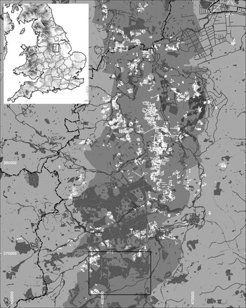
The most coherent blocks of this landscape appear to be confined to the Sherwood Sandstone of North Nottinghamshire and South Yorkshire (fig. 9), although the distribution may be more apparent than real; adjacent coal measures and mudstones are not so conducive to cropmark formation. In the medieval period this part of North Nottinghamshire became Sherwood Forest and (if never in fact entirely wooded) is still well wooded today. The frequent observation of cropmarks in gaps between woodland strongly suggests that the field-systems formerly extended beneath areas now wooded and leads to the suspicion (or hope) that earthwork remains might be preserved, particularly within areas of longer-established Ancient Woodland. However, the factors which lead to potential survival also militate against discovery, with potentially quite subtle surface traces difficult to see within woodland with varying ground cover, lack of extensive views and absence of aerial survey.
Location of study area. Brickwork-plan field-system cropmarks (white) on the Sherwood Sandstone (central grey band) west of the river Idle in north Nottinghamshire showing extent of woodland (dark grey). (Contains Ordnance Survey data. Crown Copyright and database right 2016)

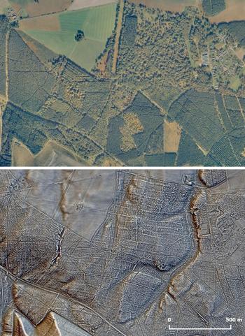
The advent of new survey techniques, in the form of LiDAR, together with advances in processing and visualisation means that it is now possible to see beneath the tree cover, enabling new insights into the extent and preservation of elements of this early field-system. In the course of Historic England funded research into the potential of LiDAR for mapping palaeochannels in the Trent catchment, available LiDAR for the whole of Nottinghamshire was processed and notwithstanding the focus on river valleys, the presence of earthwork features within some woodland areas became readily apparent. The degree of survival is varied, with nothing at all in many areas, but in some of the oldest parts of Sherwood Forest, the Birklands and Belhaugh Hays in Ollerton, Edwinstowe and Perlethorpe parishes, the results have been remarkable (fig. 10).
Belhaugh Hays ancient woodland on the Thoresby Estate in Sherwood Forest (extent shown on fig. 12). Air photograph (Google maps) and LiDAR DTM with tree cover removed showing earthworks surviving in the woodland. (LiDAR data courtesy of Environment Agency under Open Government Licence 3.0)

LiDAR
The archaeological potential of LiDAR surveys is now well established.Footnote 92 The extensive areas of slight earthwork which characterise relict field-systems can be expressed well by the technique; the presence of woodland is often a driver for preservation and the ability of LiDAR to filter out tree cover opens up previously unexplored vistas.Footnote 93
LiDAR data gathered by the Environment Agency is available under Open Government Licence with coverage at 1 m resolution for the whole of the Birklands and Bilhaugh and coverage at 0.5 m for the Birklands. All processing was undertaken on the bare-earth digital terrain model (DTM) datasets. EA LiDAR data tiles for OS grid squares SK56 and SK66 were mosaicked together to produce a continuous raster grid surface model. Further processing was undertaken using the Relief Visualization Toolbox produced by the Research Centre of the Slovenian Academy of the Sciences and Arts to produce multi-directional hill-shaded plots supplemented with other non-directional techniques, e.g. sky-view-factor and positive openness. The use of a combination of visualisation techniques is generally recommended,Footnote 94 although earlier proposals have to some degree been superseded by continuing developments in the field.Footnote 95 Hill-shaded models remain intuitively easier to read but layering with other techniques can produce clearer plots of earthwork features. The best results here have been found using positive openness merged with multi-directional hill-shaded DTMs with the processed LiDAR revealing very subtle changes in topography across the study area attributable to both natural and anthropogenic causes.
RESULTS
Birklands and Belhaugh Hays represent some of the oldest surviving woodland of Sherwood Forest, with some 450 ha designated as Ancient Woodland. The antiquarian Hayman Rooke commented on the ancient state of the woodland hereFootnote 96 and among sketches preserved in the Derby Local Studies Library is one of ‘an ancient work in Birkland near the Budby quarter’.Footnote 97
The processed LiDAR survey shows the survival of extensive earthworks beneath the tree cover of the Birklands and Belhaugh Hays over an area of c. 6.5 km2 (fig. 12). These comprise embanked fields, smaller enclosures and trackways on a co-axial pattern. The most coherent pattern lies within the Belhaugh woodland on the southern edge of Thoresby Park (fig. 10). Here a block of long narrow fields can be seen aligned WNW–ESE with cross-banks dividing the fields and a series of double-banked trackways, c. 10 m wide, separating blocks of as few as two, or as many as seven, fields. A series of small enclosures (2,500–7,000 m2) fit into the centre of the pattern with more coherent blocks of fields to the north and south. The fields are generally 60–80 m wide and 160–215 m long (although cross-banks are not as clearly evident, so few entire fields can be defined). One small enclosure, slightly misaligned but otherwise integral with the field-system, hints at more complexity in development than the apparent uniformity would imply.
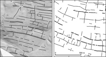
The pattern is immediately suggestive of the brickwork-plan system as side-by-side comparison makes clear (fig. 11). Cropmarks recorded immediately to the west are somewhat patchy but can be seen to continue the same alignments and there is clear continuation here of one of the trackways. To the north the cropmarks are better with a more extensive group of enclosures recorded. The alignment of the fields matches those within Belhaugh Hays to the south and can be seen to align directly on short lengths of earthwork preserved in woodland along a former avenue in the parkland.
Comparison of the field-system earthworks at Belhaugh Hays, SK 637 689 (left) with the brickwork-plan cropmarks at Barnby Moor, SK 652 851 (right).

The Birklands to the west has been subject to more exploration in recent times. Higher-resolution (0.5 m) LiDAR survey was undertaken here by Forest Research on behalf of The Friends of Thynghowe as part of Heritage Lottery funded community projects. This revealed a wealth of features including a large rectilinear enclosure (Rooke's ‘ancient work’) and a circular feature, believed to be the site of the Viking era Thinghowe, but also ‘various types and phases of earlier cultivation’.Footnote 98 The pattern of long, sinuous, parallel banks seen here is less clearly of the same character as the brickwork-plan fields. No cross-banks can be seen dividing the strips into fields and there are few indications of trackways. The one enclosure seems to stand apart on a slightly different alignment and with no clear relationship to the field banks. Overlap between the north-east of the Birklands and south-west of Belhaugh is minimal (the extensive spoil heaps of Thoresby Colliery intervene at the crucial point) but is sufficient to suggest a continuation of alignments. The scale of the earthworks and width of the blocks defined (again averaging 60–80 m) matches those to the north-east and, seen alongside the processed data for Belhaugh (fig. 12), there seems little doubt that this pattern represents further extensive survival of brickwork-plan field-system earthworks extending from the river Maun in the south almost to the river Meden in the north.
Birklands and Belhaugh Hays (see fig. 9 for location). Earthworks within the woodland (orange) with cropmarks (red). Extent of woodland (green) and Ancient Woodland (dark green) over LiDAR DTM. (Contains Ordnance Survey data. Crown Copyright and database right 2016. Lidar data courtesy of Environment Agency)

The survival of earthwork remains of the brickwork field-system within the Birklands and Belhaugh leads to two potentially exciting conclusions: firstly, the survival of earthwork features (and their associated ditches) of such antiquity may have significant potential to answer some long-standing questions on the inception, use and eventual abandonment of these large-scale field-systems, the latter with direct bearing on questions of continuity into the post-Roman period;Footnote 99 secondly, this may have significant bearing on the antiquity of Sherwood Forest itself, these parts at least possibly developing as early as the post-Roman period (or whenever it turns out the field-systems were eventually abandoned). Work continues on assessing the potential for wider survival and to map the extent of these features. A clear priority is ground-truthing, to characterise in the field and establish accessibility, with the aim of eventual ground investigation where possible in the hope of answering some of these outstanding questions.