Introduction
The period between ca. 1 and 400 AD, commonly referred to as the Roman Iron Age, represents a pivotal era in the prehistory of the southeastern Baltic region. Characterized by rapid economic and technological advancements (e.g., Vaitkunskienė and Merkevičius Reference Vaitkunskienė, Merkevičius and Volkaitė-Kulikauskienė1978; Salatkienė Reference Salatkienė2009), expanding trade networks (Michelbertas Reference Michelbertas1978), changes in burial customs (Bliujienė Reference Bliujienė2013), and shifts in settlement patterns (Vengalis Reference Vengalis, Zabiela, Baubonis and Marcinkevičiūtė2016), this period plays a crucial role in understanding the evolution of prehistoric communities in the area. Unsurprisingly, some of the most significant transformations occurred in agriculture, marked by the introduction of new crops, particularly rye and oat (Minkevičius Reference Minkevičius2020; Kulikauskas Reference Kulikauskas1955), and extensive deforestation linked to increasing agricultural activity (Stančikaitė Reference Stančikaitė2004).
While the nature of Roman Iron Age agriculture in Lithuania has been widely discussed since the mid-20th century (e.g., Kulikauskas Reference Kulikauskas1955; Kulikauskas et al. Reference Kulikauskas, Kulikauskienė and Tautavičius1961; Michelbertas Reference Michelbertas1986; Bliujienė Reference Bliujienė2013), some of the key aspects—including farming intensity, tillage methods, soil fertilization techniques, and even the landscape settings of cultivated fields—remain subjects of ongoing debate. More recent studies of subsistence economies in Late Bronze Age Lithuania (Micelicaitė et al. Reference Micelicaitė, Piličiauskienė, Podėnas, Minkevičius and Damušytė2023; Minkevičius et al. Reference Minkevičius, Piličiauskienė, Podėnas, Micelicaitė, Kontrimas, Šapolaitė, Ežerinskis, Garbaras, Čivilytė, Luik and Tamulynas2023; Podėnas et al. Reference Podėnas, Garbaras, Micelicaitė, Minkevičius, Šapolaitė, Ežerinskis and Čivilytė2023) demonstrate the potential of integrating archaeological, archaeobotanical, zooarchaeological, and isotopic data to gain more detailed insights into local prehistoric cultivation technologies.
It has been well established that light stable carbon and nitrogen isotope analyses of plant macrofossils can provide direct evidence of crop-growing conditions. The δ13C values in plants, influenced by photosynthetic rates, are impacted by water and sunlight availability (Bonafini et al. Reference Bonafini, Pellegrini, Ditchfield and Pollard2013). Meanwhile, δ15N values are linked with the uptake of organic nitrogen from decomposition, typically interpreted as an indicator of manuring practices (Fiorentino et al. Reference Fiorentino, Ferrio, Bogaard, Araus and Riehl2015). Thus, the analysis of crop remains from archaeological contexts provides a valuable perspective on the techniques, strategies, and landscape settings employed in ancient crop cultivation.
This study generates the first isotopic dataset of Roman Iron Age cereals from the southeastern Baltic, aiming to deepen the understanding of the region’s agricultural history. By conducting stable carbon and nitrogen isotope analyses of archaeobotanical assemblages from nine Lithuanian sites, this study presents a detailed view of the diverse agricultural landscapes of the time and explores the complexity of farming strategies used by Roman Iron Age communities.
Materials
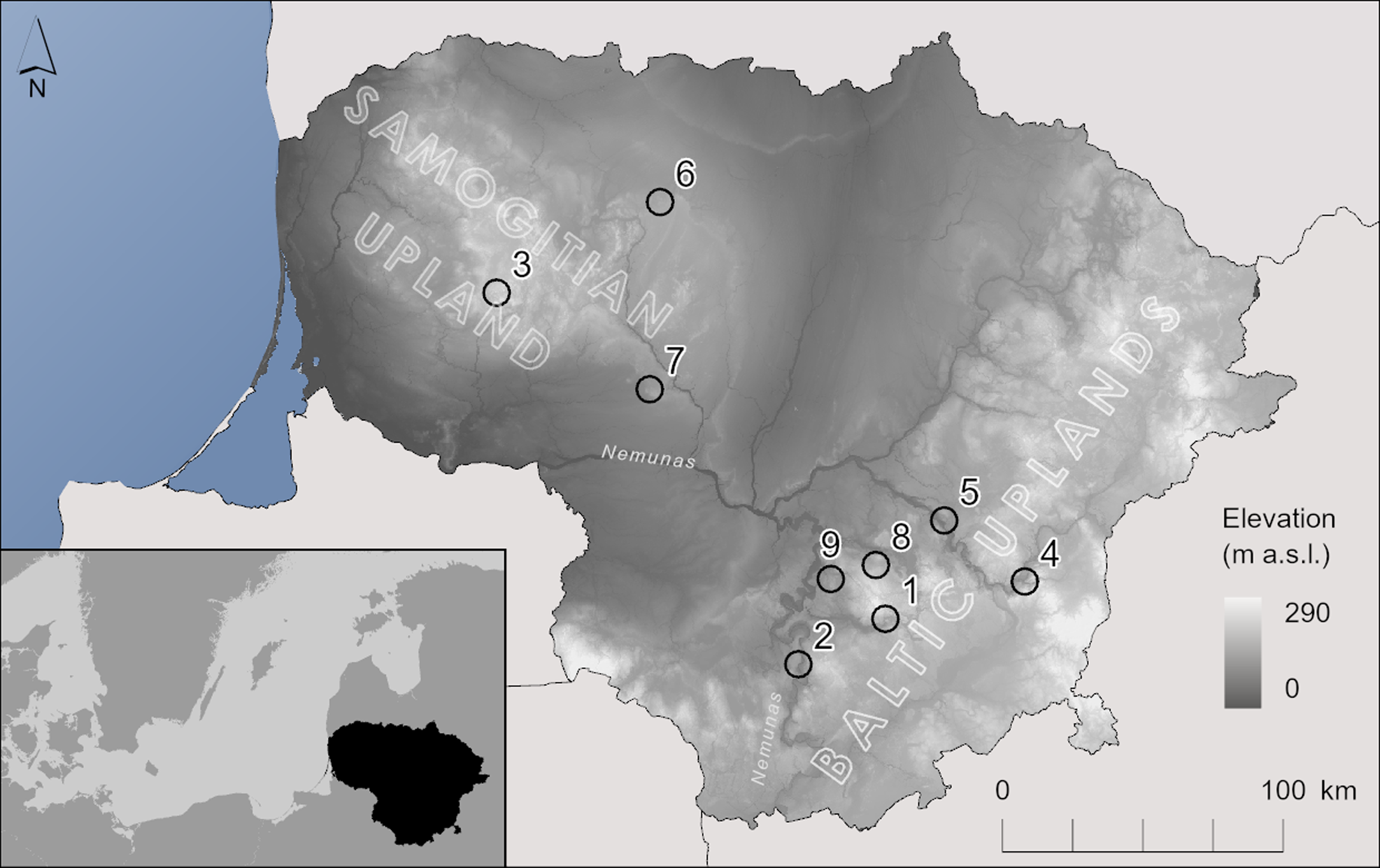
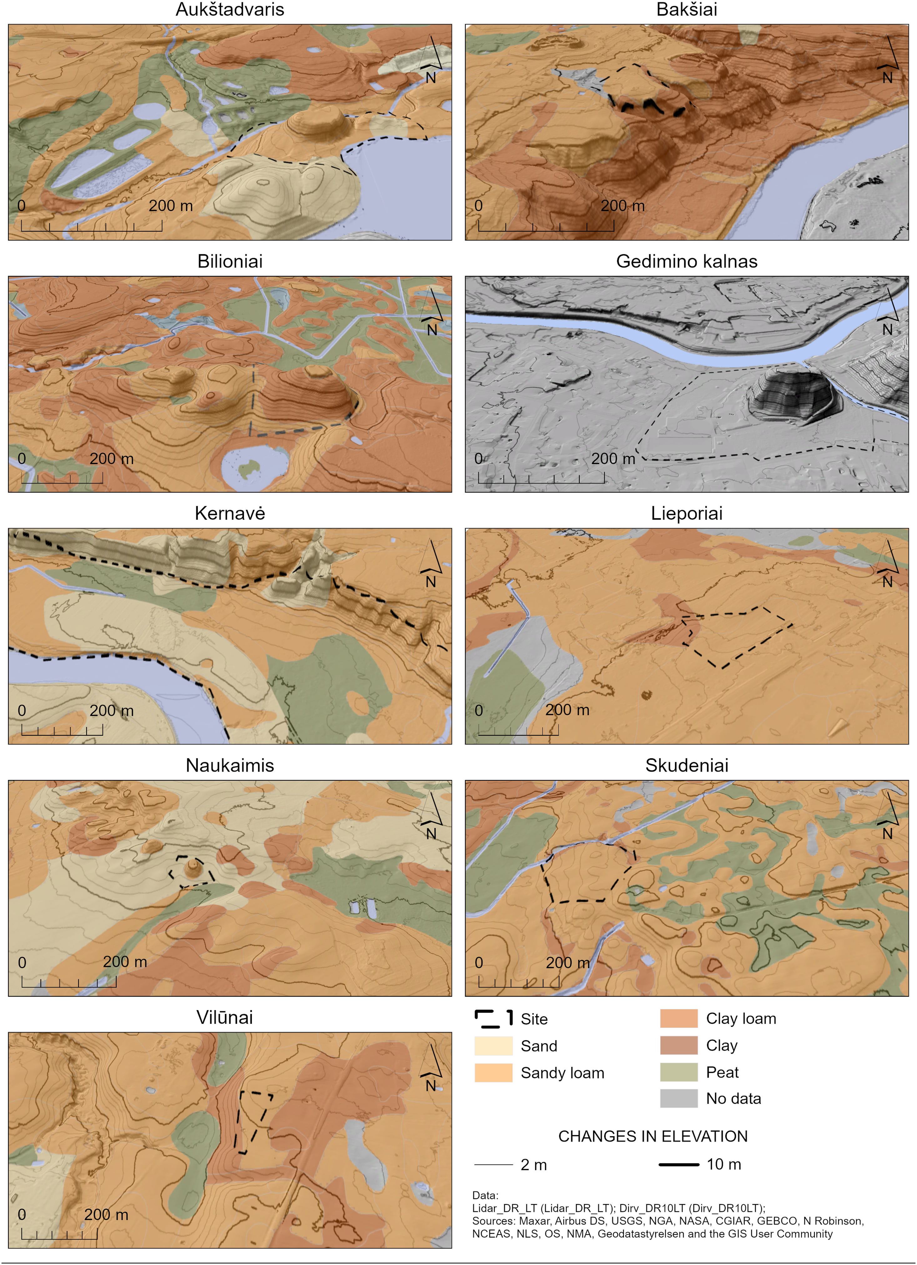
A review of archaeological collections and research documentation identified informative archaeobotanical assemblages from nine sites: Aukštadvaris, Bakšiai, Bilioniai, Gedimino kalnas, Kernavė, Lieporiai, Naukaimis, Skudeniai, and Vilūnai (Figure 1). Although most of these are multi-period sites, only material from well-preserved, undisturbed Roman Iron Age contexts such as hearths, postholes, domestic pits and storage deposits, was selected for analysis. These settlements are concentrated in two regions—Samogitian and Baltic Highlands formed during the Last Glaciation—yet they vary in topographic settings (Figure 2). Meanwhile, on a local scale, the present landscape only partially reflects the Roman Iron Age environment, as land surface, soil structure, and hydrology have been significantly altered by natural processes and human activities, particularly through the large-scale drainage projects of the mid-to-late 20th century. A brief description of each site is provided below.
Archaeological sites mentioned in the text: 1—Aukštadvaris; 2—Bakšiai; 3—Bilioniai; 4—Gedimino kalnas; 5—Kernavė; 6—Lieporiai; 7—Naukaimis; 8—Skudeniai; 9—Vilūnai.

Topography and soil types of the analyzed sites.

Aukštadvaris is a multi-period archaeological complex in southern Lithuania (54°34′23.3″N, 24°31′9.9″E). It consists of a hillfort and a nearby unenclosed settlement, positioned between the Verknė River and Pilaitė Lake. It sits on a glacial moraine, in a terrain characterized by steep hills. The surrounding landscape mainly consists of light soils—sands and sandy loams. The site was excavated in 1957–1960, unearthing an area of 956 m2 on the hilltop. Excavation revealed five distinctive phases of occupation, covering a timespan from ca. 2nd c. BC to 17th century AD (Daugudis Reference Daugudis, Kuncevičius, Jovaiša and Šimėnas1998). In 1959 charred remains of a 2nd–3rd c. wooden building were discovered on the western part of the hillfort. Alongside archaeological finds such striated and burnished pottery fragments, the interior of the building contained a charred assemblage of various crop species, likely intermixed during the house fire. This represents a well-preserved domestic setting, likely reflecting household storage and consumption practices. Two subsamples were selected from the context for archaeobotanical analysis and isotopic study.
Bakšiai is an unenclosed settlement located in the northern part of Alytus, southern Lithuania (54°26′13.2″N,24°2′34.8″E), situated on the upper terrace of the Nemunas River, overlooking a floodplain to the south. The plateau consists of glacial moraine with sandy loams, while the lowland is a sandy fluvioglacial valley. Excavations covering 3581 m2 were carried out between 1981 and 1998, revealing remains of a 3rd–4th century AD settlement (Steponaitis Reference Steponaitis2000). These included fragments of a cultural layer, imprints of house walls, and other features such as postholes, pits, hearths, and an iron smelting furnace. Soil samples for this study were collected from two pits and a hearth, alongside several fragments of faunal skeletal remains from the cultural layer, all associated with the dwelling area and potentially linked to domestic refuse and food processing activities.
Bilioniai hillfort, located in western Lithuania (55°35′49″N, 22°19′17″E), is an isolated hill. The site rests on glacial moraine within a hilly terrain, predominantly consisting of sandy and clayey loams. Excavations conducted between 2017 and 2019 investigated four trenches—a total area of 59 m2—on the hilltop. The investigation uncovered evidence of three distinct occupational phases dating to the 2nd–3rd c., 10th–12th c., and 14th c. (Zabiela Reference Zabiela2018). The Roman Iron Age layer was well-preserved, and in 2017, the remains of a burnt wooden dwelling were found. Alongside fragments of rusticated pottery and clay daub, a wooden storage container made of birch bark, was uncovered. It contained charred grain assemblage, mainly composed of glume wheats and linked with the surplus storage (Minkevičius Reference Minkevičius and Zabiela2019), which was analyzed and sampled by the authors for this study. In 2018, a burnt down fortification from 10th–12th c. was uncovered, which contained a layer rich in charred grains. This provided a rare opportunity for a direct comparison of changes in crop isotopic values from the same site over time. Therefore, the context was also sampled for the isotopic study. Gedimino kalnas, located in Vilnius (54°41′12″N, 25°17′27″E), eastern Lithuania, is situated at the confluence of the Neris and Vilnia rivers. The hill belongs to the fiuvioglacial terrace of the Neris River, from which it was separated by the Vilnia River only in historical times, when a new channel was dug for defence purposes of Gediminas Castle (Vodzinskas Reference Vodzinskas1960). The site is multi-period, spanning from the Late Bronze Age to the 17th century, and has undergone significant transformation with each successive occupation phase. Excavations on the hillfort began as early as 1940, led by Helena Hołubowiczowa and Włodzimierz Hołubowicz (Holubovičiai Reference Holubovičiai1941). In 2019, an area of 123 m2 was excavated around the perimeter of the hilltop. In the western section, a fragment of an undisturbed Roman Iron Age layer was discovered. This layer contained fragments of Iron Age pottery, clay daub, and a trilobate arrowhead (Kontrimas, Reference Kontrimas2020). While the small area of this layer prevents firm interpretation, the nature of the archaeological finds suggests this was the outskirts of a dwelling area. Soil samples from this context were taken for archaeobotanical analysis, and charred crop macrofossils were selected for isotopic study.
During the Roman Iron Age, Kernavė was a sizeable settlement (ca. 140 ha), composed of both an unenclosed fortified part on top of the upper Neris terrace and unenclosed farmsteads in the floodplain to the south. Located in eastern Lithuania (54°53′9.6″N, 24°51′14.4″E), the site’s geological stratigraphy consists of moraine covered by limnoglacial deposits, overlaying sandy interglacial layers. The upper layers are not uniform, consisting of layers of sand and clayey loams (Vengalis et al. Reference Vengalis, Volungevičius, Vėlius, Kuncevičius, Poškienė and Prapiestienė2020). Continuous investigation since 1979 has integrated an increasing range of interdisciplinary methods, resulting in one of the richest and most comprehensive archaeobotanical datasets. This dataset, noted for its exceptional spatial and chronological coverage, allows for isotopic analysis on samples from various settlement contexts (Minkevičius et al. Reference Minkevičius, Vengalis, Piličiauskienė, Poškienė, Pilkauskas and Vėlius2024). For this study, samples were selected from two primary areas: the fortified hilltop settlement known as “Aukuro kalnas” and the unenclosed farmsteads in the valley. Postholes and domestic pits associated with dwelling areas were sampled, selecting plant macrofossils for isotopic analysis
Lieporiai is a sizeable unenclosed settlement in northern Lithuania (ca. 20 ha), located on the southwestern fringes of the city of Šiauliai (55°54′21.6″N, 23°16′1.2″E). The site sits on a small hill within flat terrain, with the surrounding landscape shaped by a glacial moraine predominantly composed of light, sandy loams. From 1991 to 2016 excavations were conducted at the site, uncovering a total area of 3009 m2. The site contains a rich Roman Iron Age horizon, featuring a cultural layer, remains of buildings, timber wells, iron smelting furnaces, and negative features such as postholes and pits (Salatkienė and Grigas Reference Salatkienė and Grigas2017). Among the discoveries were two domestic pits and a nearby well, associated with household activities. These contexts were sampled for plant macrofossils and faunal remains, analyzed by the authors of this study and included in the isotopic analysis. Naukaimis is a small hilltop settlement located in central Lithuania (55°17′40.8″N, 23°11′33.3″E). The site is situated on an isolated hill within a hilly fluvioglacial landscape, primarily composed of light sands and sandy loams. Excavations conducted in 1910 by Ludwik Krzywicki uncovered an area of 350 m2 on the southern side of the hilltop, revealing a 3rd–4th century AD cultural layer that included fragments of rusticated pottery, clay daub, and six Imperial Roman coins (Kulikauskas et al. Reference Kulikauskas, Kulikauskienė and Tautavičius1961). Among the archaeological features, a large, 2.5 m diameter stone-paved storage pit with substantial assemblage of charred cereal grains alongside fragments of a wooden container, made from birch bark was discovered (Michelbertas Reference Michelbertas1986). This assemblage, dominated by rye grains, likely represents the remains of a single harvest. The archaeobotanical material was initially reported shortly after the excavations (Lideikytė–Šopauskienė Reference Lideikytė–Šopauskienė1935) and after a recent re-examination of the finds (Minkevičius Reference Minkevičius2020) was sampled for this study.
Skudeniai is an unenclosed Roman Iron Age settlement located in central Lithuania (54°46′ 12″N, 24°27′18″E). The site is situated on hilly terrain with clayey, poorly draining soils. Geomorphologically, it lies between two distinct landform types: a lightly undulating glaciodepression traversed by the Kertus River and several small, overgrown lake basins to the west, and morainic hilly uplands to the east (Vengalis et al. Reference Vengalis, Piličiauskas, Minkevičius, Valančius, Stančikaitė, Vaikutienė and Piličiauskienė2022). Discovered and excavated in 2020, the investigation covered an area of 2500 m2. The excavations revealed the remains of a short-term settlement dating to approximately 130–240 cal AD. Distinct activity areas were identified through the distribution of archaeological material, enabling systematic sampling for plant macrofossils across the site. Material from two nearby dwelling areas was chosen for this study. Floral remains were sampled from the postholes of the houses, and the faunal remains were collected from accompanying cultural layer deposits, reflecting subsistence activities during a relatively short occupation phase.
The Roman Iron Age settlement at Vilūnai is located in central Lithuania (54°42′18″N, 24°13′15.6″E). The site is situated on hilly glacial moraine between the Lapainia and Melnyčėlė rivers, surrounded by a landscape primarily composed of sandy and clay loams. Discovered in 2020, the site was excavated by Elena Pranckėnaitė, covering an area of 417 m2. The excavations revealed the remains of an unenclosed settlement dating to the 1st–3rd centuries AD (Pranckėnaitė et al. Reference Pranckėnaitė, Masiulienė and Zabiela2021). Based on the distribution of domestic pottery, clay daub fragments and other finds, a part of the settlement was interpreted as a dwelling area. Several domestic pits and sections of the cultural layer from this zone were sampled for zooarchaeological and archaeobotanical material, which was subsequently used for isotopic analysis.
The plant remains, collected during both the recent and the legacy excavations, are housed at Vytautas the Great War Museum (Kaunas), the National Museum of Lithuania (Vilnius), and the Archaeological Site Museum of Kernavė. The assemblages were re-examined through archaeobotanical analysis and a review of research documentation, with only informative and representative samples selected for isotopic analysis. This was supplemented by zooarchaeological material housed at the Vilnius University Laboratory of Zooarchaeology. However, the re-examination of faunal remains revealed that suitable material was available from only four sites—Bakšiai, Lieporiai, Skudeniai, and Vilūnai. Therefore, the dataset integrates archaeobotanical and zooarchaeological data to a limited extent.
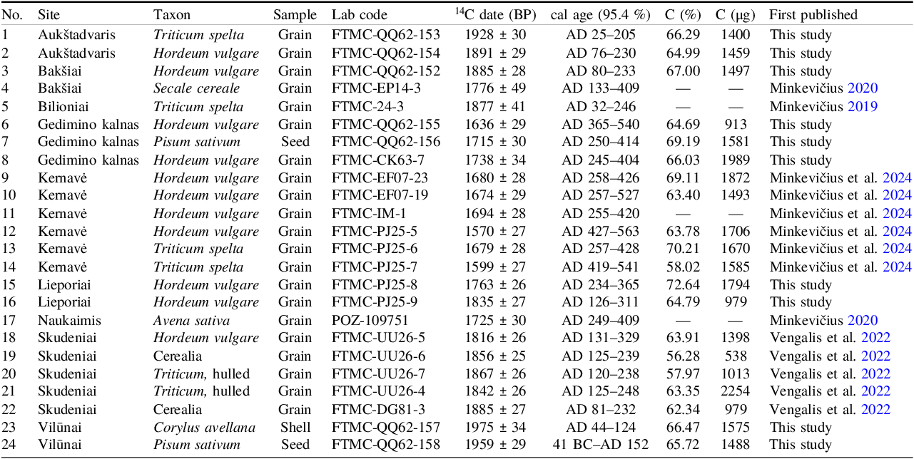
Ten charred plant macrofossils were submitted for radiocarbon dating (Table 1). Samples for radiocarbon dating were selected from the contexts used for isotopic analysis, prioritizing well-preserved charred cereal grains from short-lived archaeological features such as postholes, domestic pits, and storage deposits. This approach aimed to minimize potential residuality and ensure chronological relevance.
AMS 14measurements of charred plant macrofossils from the sites analyzed in this study

A total of 204 plant macrofossils were selected for stable isotope analysis, including charred grains from each of the main Roman Iron Age cereal species: common oat (Avena sativa), barley (Hordeum vulgare), rye (Secale cereale), free-threshing wheat (Triticum aestivum/durum), emmer (Tr. dicoccon) and spelt (Tr. spelta) (Supplementary Table 1). In some cases, the availability of archaeobotanical material posed significant limitations for sample selection. However, the recommendations of selecting 5–10 grains of each taxon per context (Heaton et al. Reference Heaton, Jones, Halstead and Tsipropoulos2009; Riehl et al. Reference Riehl, Pustovoytov, Weippert, Klett and Hole2014) and using samples with preservation states between P1 and P3 (Boardman and Jones Reference Boardman and Jones1990) were followed as closely as possible throughout the process. Due to the limited availability of the material analysis was performed on single grains to ensure the internal consistency within the dataset.
Methods
AMS radiocarbon (14C) dating was conducted at the Mass Spectrometry Laboratory, Centre for Physical Sciences and Technology, Vilnius. Samples underwent standard acid-base-acid (ABA) pre-treatment following Molnár et al. (Reference Molnár, Janovics and Major2013). Graphitization was performed using Automated Graphitization Equipment AGE-3 (IonPlus AG), and radiocarbon measurements were taken with a single-stage accelerator mass spectrometer (SSAMS, NEC, USA), following Ežerinskis et al. (Reference Ežerinskis, Šapolaitė and Pabedinskas2018). Phthalic anhydride was used for measurement background estimation (2.45×10⁻³ fM). The 14C/1 2C ratio was measured with better than 0.3% precision. For isotopic fractionation correction, the AMS-measured 1 3C/1 2C ratio was used. Radiocarbon dates were calibrated using OxCal v4.4 and the IntCal20 atmospheric curve (Bronk Ramsey Reference Bronk Ramsey2009; Reimer et al. Reference Reimer, Austin, Bard, Bayliss, Blackwell, Ramsey, Butzin, Cheng, Edwards, Friedrich and Grootes2020), with calibrated dates reported at 95.4% probability.
Each specimen underwent standard chemical pre-treatment using the acid-base-acid (ABA) method. Isotopic measurements were conducted at the Centre for Physical Sciences and Technology, Vilnius, using a Thermo Flash EA 1112 elemental analyzer coupled with a Thermo Finnigan Delta+ Advantage mass spectrometer. Isotope data were normalized to the VPDB (Vienna Pee Dee Belemnite) scale for carbon (C) and AIR (atmospheric nitrogen) for nitrogen (N), utilizing IAEA standards. The δ13C and δ15N values of the carbonized crop remains were adjusted for charring effects by subtracting 0.11‰ and 0.31‰, respectively (Nitsch et al. Reference Nitsch, Charles and Bogaard2015). Δ13C values were calculated using the AIRCO2_LOESS calibrator (Ferrio et al. Reference Ferrio, Araus, Buxó, Voltas and Bort2005) and the methodology of Farquhar et al. (Reference Farquhar, O’Leary and Berry1982). The δ15N baselines for wild unmanaged plants in Bakšiai, Lieporiai, Skudeniai and Vilūnai were estimated by subtracting the mean offset for herbivore diets (4‰) (Bogaard et al. Reference Bogaard, Fraser, Heaton, Wallace, Vaiglova, Charles, Jones, Evershed, Styrink, Anderson, Arbogast, Bartosievicz, Gardeisen, Kanstrup, Maier, Marinova, Ninov, Schäfer and Stephan2013) from the mean Roman Iron Age herbivore bone collagen δ15N for each site (Table S2).
A total of 23 animal bone samples and 1 tooth sample were selected for δ13C and δ15N stable isotope analysis at the Centre for Physical Sciences and Technology in Vilnius. Bone collagen extraction followed the acid-alkali-acid (AAA) method, followed by gelatinisation (Szidat et al. Reference Szidat, Vogel, Gubler and Lösch2017). Samples were treated with 0.5M hydrochloric acid, 0.1M sodium hydroxide, and a second 0.5M hydrochloric acid wash. The gelatinisation process was conducted in a pH 3 solution at 70°C for 20 hours. The resulting gelatin solution was filtered using a cleaned Ezee-filter and then freeze-dried. Stable carbon and nitrogen isotope ratios in the bone collagen were measured using an elemental analyzer (Thermo Flash EA 1112) coupled with an Isotope Ratio Mass Spectrometer (Thermo Finnigan Delta Plus Advantage). The analytical precision was ±0.1‰ for δ13C and ±0.15‰ for δ15N. Isotope data are reported as δ values in permille (‰), referenced to international standards: VPDB for δ13C and AIR for δ15N. Collagen integrity was assessed using four quality indicators, following established criteria (De Niro Reference DeNiro1985; Ambrose Reference Ambrose1990; Van Klinken Reference Van Klinken1999), to ensure the samples were of sufficient quality.
Results and discussion
Chronology
To establish the timeline for the analyzed contexts, the AMS 14C dating results were supplemented by 14 previously reported radiocarbon dates, resulting in a total of 24 dates used to define the chronological boundaries of the material. The analyzed material spans from approximately 0 to 550 cal AD, covering the entirety of the Roman Iron Age (1st to 4th c. AD) and the beginning of the Migration Period (5th to 6th c. AD), based on the established periodization of Lithuanian prehistory (Bliujienė Reference Bliujienė2013).
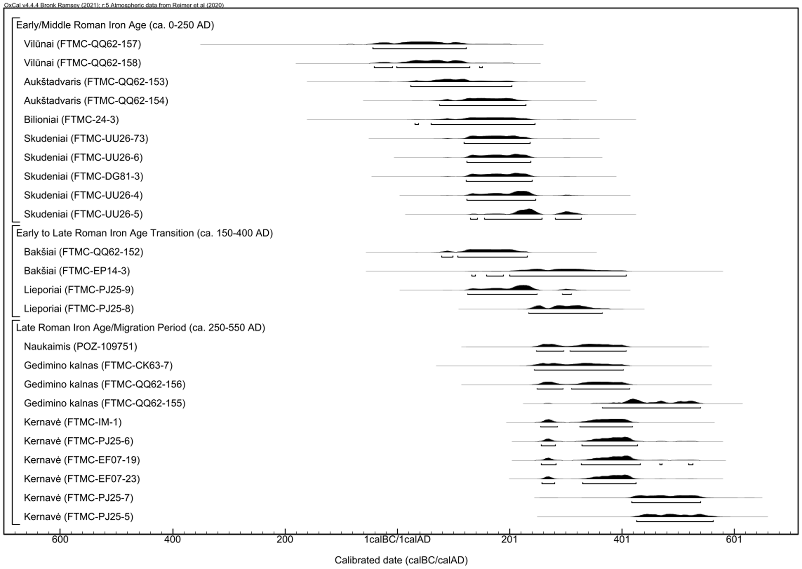
Radiocarbon dating indicates that the analyzed contexts cover the full extent of the period without chronological gaps and could be divided into two distinct phases (Figure 3). The earlier phase, dating from approximately 50 BC to 250 cal AD, includes four sites: Vilūnai (41 cal BC–AD 152), Aukštadvaris (25–230 cal AD), Bilioniai (32–246 cal AD), and Skudeniai (81–248 cal AD). The finds of the early rusticated ware at Bilioniai and Skudeniai suggest they may belong to the end of the phase, as this pottery style dates to the 3rd to 5th c. AD (Vengalis Reference Vengalis2007).
Calibration plot of AMS 14C dates from the archaeobotanical assemblages analyzed in this study.

Two sites, Bakšiai (80–409 cal AD) and Lieporiai (126–365 cal AD), represent a possible transitional period. Radiocarbon dates and the typochronology of pottery suggest that both sites likely date to the 3rd–4th c. AD (Salatkienė and Grigas Reference Salatkienė and Grigas2017; Steponaitis Reference Steponaitis2000). While this partially overlaps with both the earlier and later phases, it is also plausible that this period represents a distinct stage, defined by the existence of unenclosed settlements typical of late 2nd to 4th century Lithuania (Vengalis Reference Vengalis, Zabiela, Baubonis and Marcinkevičiūtė2016).
The later phase, dating from approximately 250 to 550 cal AD, includes three sites: Naukaimis (249–409 cal AD), Gedimino kalnas (245–540 cal AD), and Kernavė (255–563 cal AD). The assemblages from Naukaimis and Gedimino kalnas likely date to the 3rd–5th c. AD, based on radiocarbon dates and the chronology of associated finds (Kontrimas Reference Kontrimas2020; Kulikauskas Reference Kulikauskas1955). In contrast, the archaeobotanical material from Kernavė likely represents the end of this phase, with contexts dating from the 5th to 6th c. AD (Minkevičius et al., Reference Minkevičius, Vengalis, Piličiauskienė, Poškienė, Pilkauskas and Vėlius2024). This corresponds with the introduction of rye at the site, marking the final stage of the Roman Iron Age agricultural transition. Stratigraphic analysis indicates that samples from the enclosed hilltop settlement at Kernavė predate the 5th c. fire (Vengalis and Vėlius Reference Vengalis and Vėlius2019), whereas samples taken from the valley could not be dated more precisely.
The early dating of Vilūnai assemblages is particularly important due to the rye grains discovered in the contexts. Previous studies have dated the introduction of rye cultivation in Lithuania to the 2nd/3rd c. AD (Vengalis et al. Reference Vengalis, Piličiauskas, Minkevičius, Valančius, Stančikaitė, Vaikutienė and Piličiauskienė2022), similar to or slightly later than in other parts of northern Europe (Grabowski Reference Grabowski2011). However, the radiocarbon dating from Vilūnai strongly points to the cultivation of rye—one of the most significant agricultural innovations in Roman Iron Age Lithuania—potentially starting as early as the 1st to mid-2nd c. AD.
Furthermore, the spatial and chronological distribution of rye finds suggests its introduction from the south—possibly from central-eastern Europe—along the Nemunas River axis. This corresponds with the import vectors of some of the most distinctive imported artefacts during the 1st c. AD, reaching Lithuania from the Roman provinces via the River Nemunas and its tributaries (e.g., Michelbertas Reference Michelbertas1995). This is particularly significant, as it points to a previously overlooked vector for agricultural innovations complementing the established circum-Baltic and Dauguva River trade networks active in the 1st millennium BC (Podėnas Reference Podėnas2024). It may also help explain the seemingly late adoption of rye in regions such as northeast Lithuania.
Isotopic composition (δ15N and δ1 3C) of cereal and faunal remains
A total of 204 charred cereal grains were subjected to isotopic analysis (Supplementary Table 1). Of these, 197 samples contained sufficient combustible nitrogen to produce δ15N measurements. δ15N values could not be obtained for barley grains from Bakšiai (n=1), Gedimino kalnas (n=1), and Lieporiai (n=2); spelt grains from Kernavė (n=1) and Skudeniai (n=1); and a rye grain from Vilūnai (n=1) due to low nitrogen content in the charred plant remains. By comparison, all samples contained sufficient carbon for δ1 3C measurements. The dataset consists of 191 samples from Roman Iron Age sites and thirteen additional samples from the later phase at Bilioniai hillfort, collected from a 900–1100 AD context to examine shifts in cultivation conditions at the site over time.
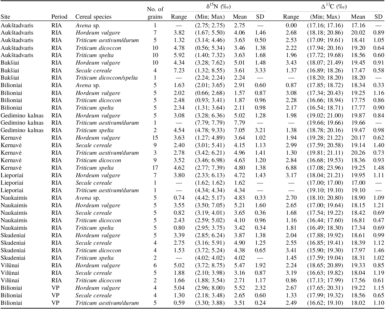
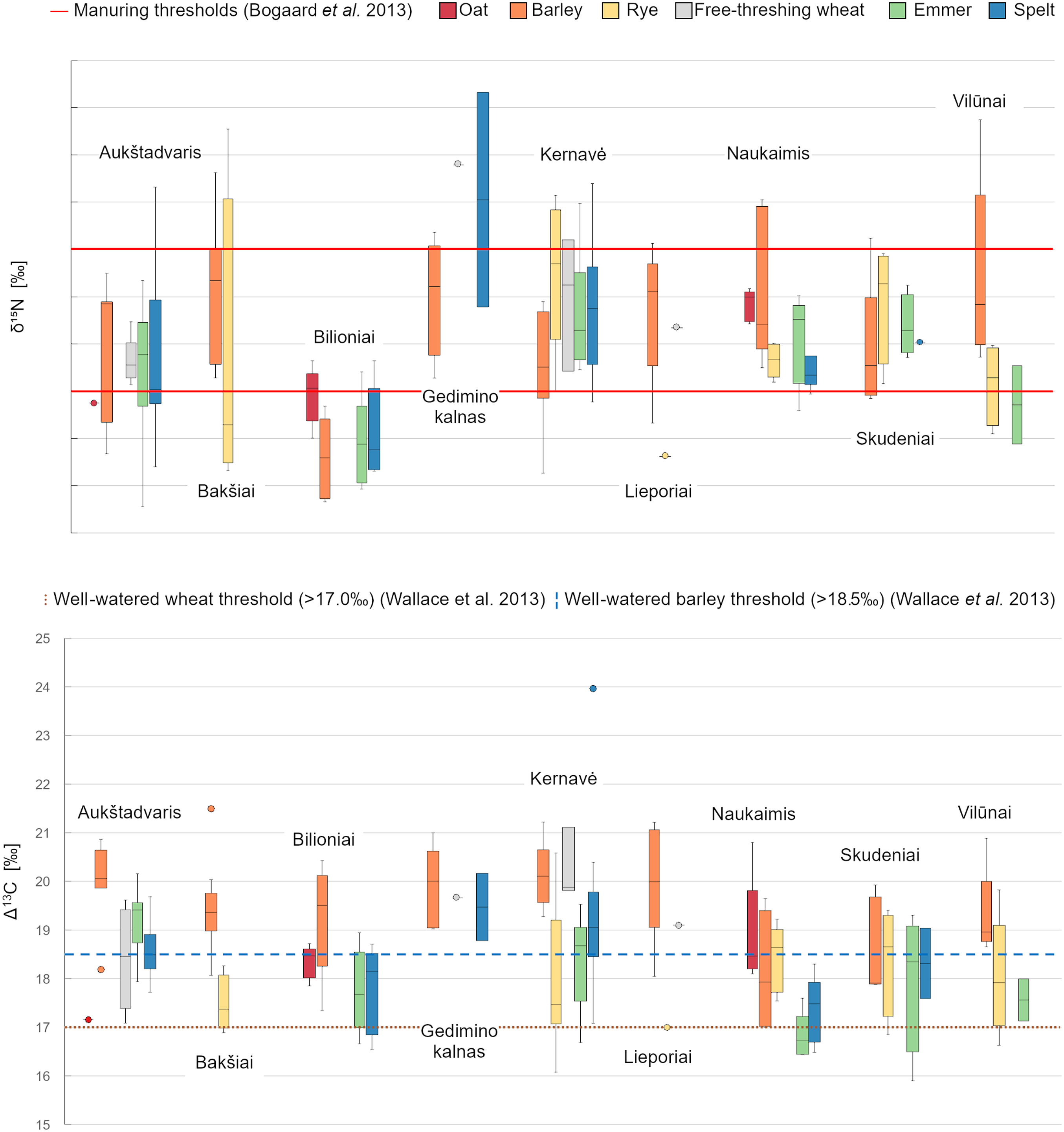
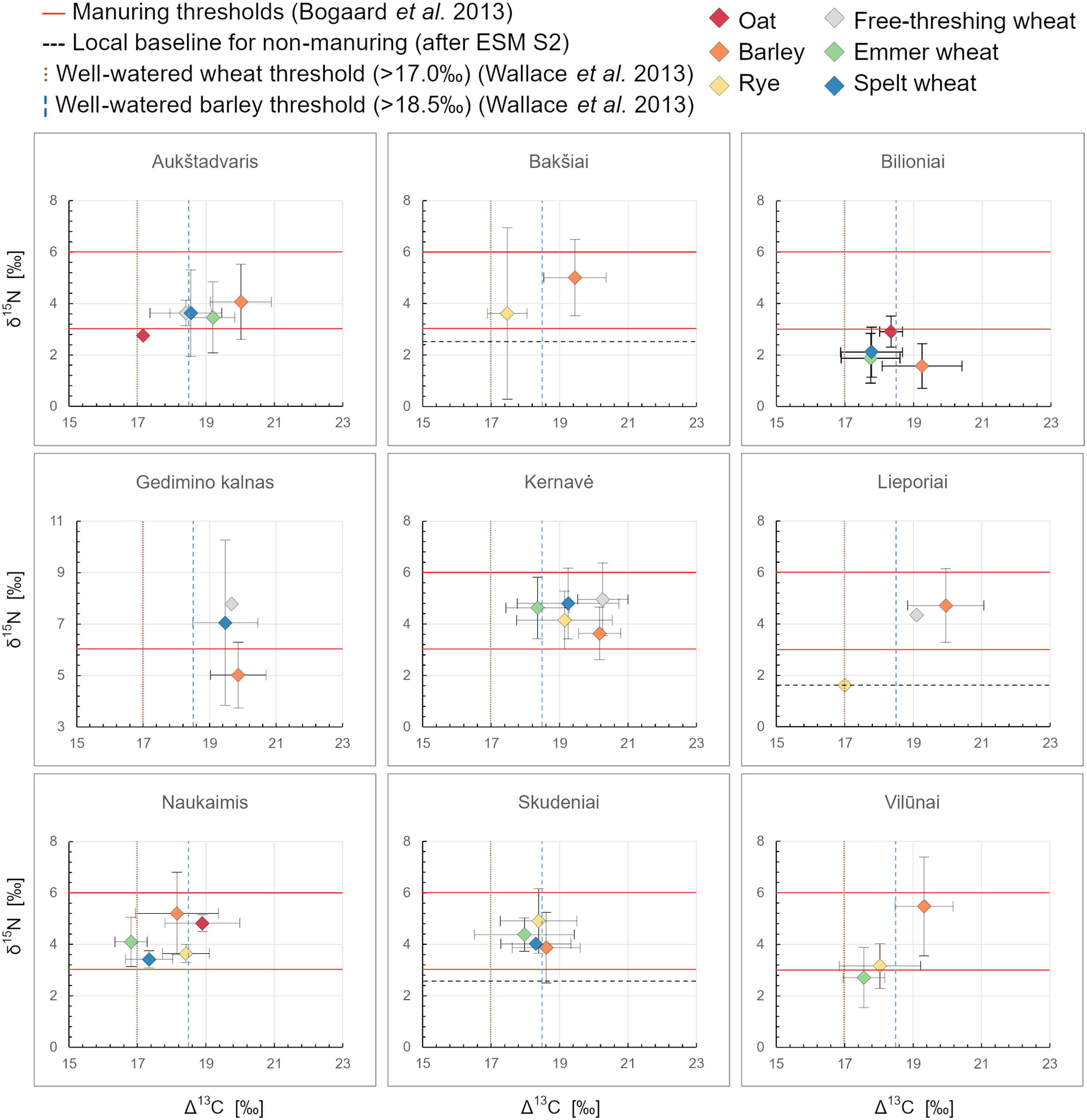
Stable isotope results from charred cereal grains reveal variation in δ15N and Δ1 3C values across sites and species (Table 2). At Aukštadvaris, mean cereal δ15N values were relatively moderate, ranging from 3.5‰ in emmer to 4.1‰ in barley, except for a single oat grain with a lower value (2.75‰) (Figure 4, 5). The widest range was recorded in spelt (1.4‰ to 7.3‰), reflecting considerable variability in nitrogen content within this species. Mean Δ1 3C values varied slightly between species but remained consistent overall, ranging from 18.4‰ in free-threshing wheat to 20.0‰ in barley, with the single oat grain measured at 17.2‰.
Summary statistics for the δ15N and Δ13C values of cereal grains from the assemblages analyzed in this study, after adjusting for charring effects. RIA=Roman Iron Age; VP=Viking Period

Summary of δ15N and Δ13C values by site and taxon. Boxplots show the median, interquartile range (IQR), and whiskers extending to 1.5×IQR; outliers are plotted individually.

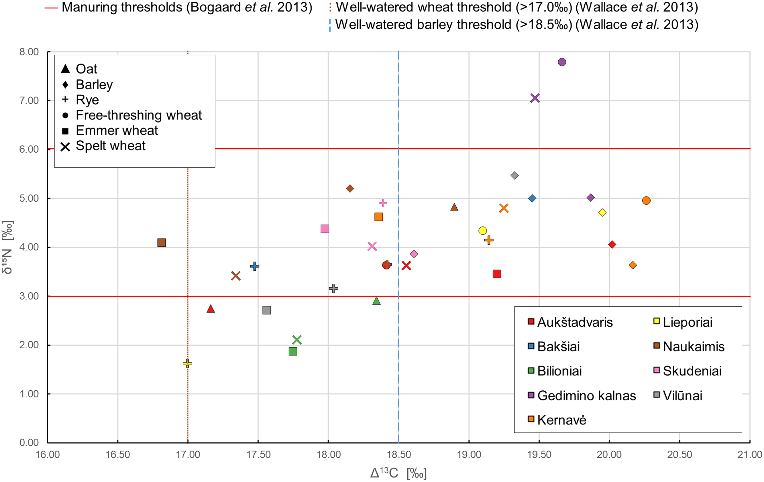
Distribution of the mean δ15N and Δ13C values from the analyzed assemblages, grouped by site and taxon.

At Bakšiai, barley and rye grains showed clear isotopic differences, with barley having a higher mean δ15N value (5.0‰) than rye (3.6‰). Carbon isotope values followed a similar pattern: barley exhibited a mean Δ1 3C of 19.5‰, while rye averaged 17.5‰. A single hulled wheat grain was also analyzed, yielding δ15N and Δ1 3C values of 2.2‰ and 18.2‰, respectively.
From the Roman Iron Age context at Bilioniai, isotopic values were generally lower compared to other sites. Oats had the highest mean δ15N value (2.9‰), while barley, emmer, and spelt showed similar, lower values ranging from 1.6‰ to 2.1‰. Mean Δ1 3C values were lowest for emmer and spelt (17.8‰), while oat and barley recorded higher values of 18.3‰ and 19.3‰, respectively.
At Gedimino kalnas, only eight cereal grains were available for analysis. Barley had a noticeably lower mean δ15N value (5.0‰) compared to spelt (7.1‰) and a single free-threshing wheat grain (7.8‰). Mean Δ1 3C values were relatively consistent across species, ranging from 19.5‰ to 19.9‰.
The dataset from Kernavė, the largest analyzed, showed mean δ15N values ranging from 3.6‰ in barley to 5.0‰ in free-threshing wheat. The greatest variation in δ15N was observed in spelt, while rye and free-threshing wheat showed relatively stable isotope ratios. Mean Δ1 3C values were similar across most species, except for spelt, which displayed considerable variation (17.1‰ to 24.0‰).
At Lieporiai, nine grains were analyzed, with barley dominating the assemblage. Mean δ15N and Δ1 3C values for barley measured 4.7‰ and 20.0‰, similar to the single free-threshing wheat grain (4.3‰ and 19.1‰, respectively). In contrast, the single rye grain displayed distinctly lower values (δ15N of 1.6‰ and Δ1 3C of 17.0‰).
At Naukaimis, barley showed the highest mean δ15N value (5.2‰), followed by oat and emmer. Rye and spelt presented noticeably lower nitrogen values (3.7‰ and 3.4‰, respectively). The Δ1 3C values ranged from 16.8‰ to 18.9‰, with barley showing the highest values and glume wheats the lowest.
From Skudeniai, mean δ15N values ranged from 3.9‰ for barley to 4.9‰ for rye. Emmer and spelt yielded similar nitrogen values (4.4‰ and 4.0‰, respectively). Mean Δ1 3C values were also comparable across species, ranging from 18.0‰ to 18.6‰, with barley recording the highest and emmer the lowest measurements.
At Vilūnai, barley exhibited the highest δ15N values, ranging from 3.7‰ to 8.8‰, while rye showed distinctly lower values (2.1‰ to 4.0‰). The two emmer grains analyzed measured 1.9‰ and 3.5‰. Barley also showed the highest Δ1 3C values (mean 19.3‰), compared to 18.0‰ in rye and 17.6‰ in emmer.
This provides a comprehensive overview of isotopic values for different crops across most sites. However, in cases where only single grains of certain taxa were available, the representativeness of these values should be interpreted with caution. Single-grain results may reflect variation in growing conditions, seasonal differences, or even variability within a single crop. Nevertheless, the isotopic values of single wheat grains from Bakšiai, Gedimino kalnas, and Lieporiai are comparable to those of barley, suggesting similar cultivation regimes. In contrast, the δ15N and Δ1 3C values of the single rye grain from Lieporiai fall distinctly below the barley isotopic range, indicating growth in markedly different environmental conditions. This suggests that while signals from individual grains should not be overstated, they can still provide valuable insights into agricultural practices at these sites.
Additionally, δ1 3C and δ15N analysis was performed on 24 bone samples from domestic and wild herbivores and omnivores across four sites. However, due to insufficient collagen preservation, isotopic values were successfully measured in only 13 samples—Bakšiai (n=5/4), Lieporai (n=8/5), Skudeniai (n=3/2), and Vilūnai (n=8/2) (Supplementary Table 2). The average δ1 3C value for cattle (n=2) was −22.4±4.1‰, while δ15N averaged 7.1±2.4‰. Sheep/goat (n=4) exhibited mean δ1 3C and δ15N values of −21.7±0.3‰ and 5.4±0.46‰, respectively. Pigs (n=2) had δ1 3C values of −21.8±0.57‰ and δ15N values of 6.2±1.6‰. In comparison, horses displayed a mean δ1 3C value of −22.8±0.1‰ and a mean δ15N value of 6.1±1.5‰. While the dataset is relatively small, limiting broader interpretations of livestock herding practices and habitat use, the δ1 3C and δ15N values of Roman Period domesticates are comparable to those of 1st millennium BC animals (Minkevičius et al. Reference Minkevičius, Piličiauskienė, Podėnas, Micelicaitė, Kontrimas, Šapolaitė, Ežerinskis, Garbaras, Čivilytė, Luik and Tamulynas2023). This suggests similar foddering strategies and pasturing in manured fields. Notably, the highest natural δ15N baseline among the analyzed sites was observed in Vilūnai (2.6‰), confirming that nitrogen values in unmanured fields generally do not exceed the estimated 3.0‰ threshold.
Crop management and growing conditions
The isotopic analysis of Roman Iron Age cereal remains provides new, direct insights into the longstanding debate on agricultural practices in 1st-millennium AD Lithuania. Earlier studies have indicated an increase in deforestation at the onset of the Roman Iron Age (Daugnora et al. Reference Daugnora, Girininkas, Guobytė, Kisielienė, Simniškytė and Stančikaitė2004; Stančikaitė Reference Stančikaitė2004; Stančikaitė et al. Reference Stančikaitė, Simniškytė, Skuratovič, Gedminienė, Kazkauskas and Uogintas2019), often attributed to extensive farming methods involving slash-and-burn techniques (Bliujienė Reference Bliujienė2013; Kulikauskas et al. Reference Kulikauskas, Kulikauskienė and Tautavičius1961; Tautavičius Reference Tautavičius1996). However, recent archaeobotanical and isotopic studies of Late Bronze Age (ca. 1100–400 cal BC) assemblages from Lithuania suggest that intensive, permanent field agriculture, characterized by crop diversity, manuring and regular field maintenance, may have been established in the southeastern Baltic region as early as the 1st millennium BC (Minkevičius et al. Reference Minkevičius, Podėnas, Urbonaitė-Ubė, Ubis and Kisielienė2020, Reference Minkevičius, Piličiauskienė, Podėnas, Micelicaitė, Kontrimas, Šapolaitė, Ežerinskis, Garbaras, Čivilytė, Luik and Tamulynas2023).
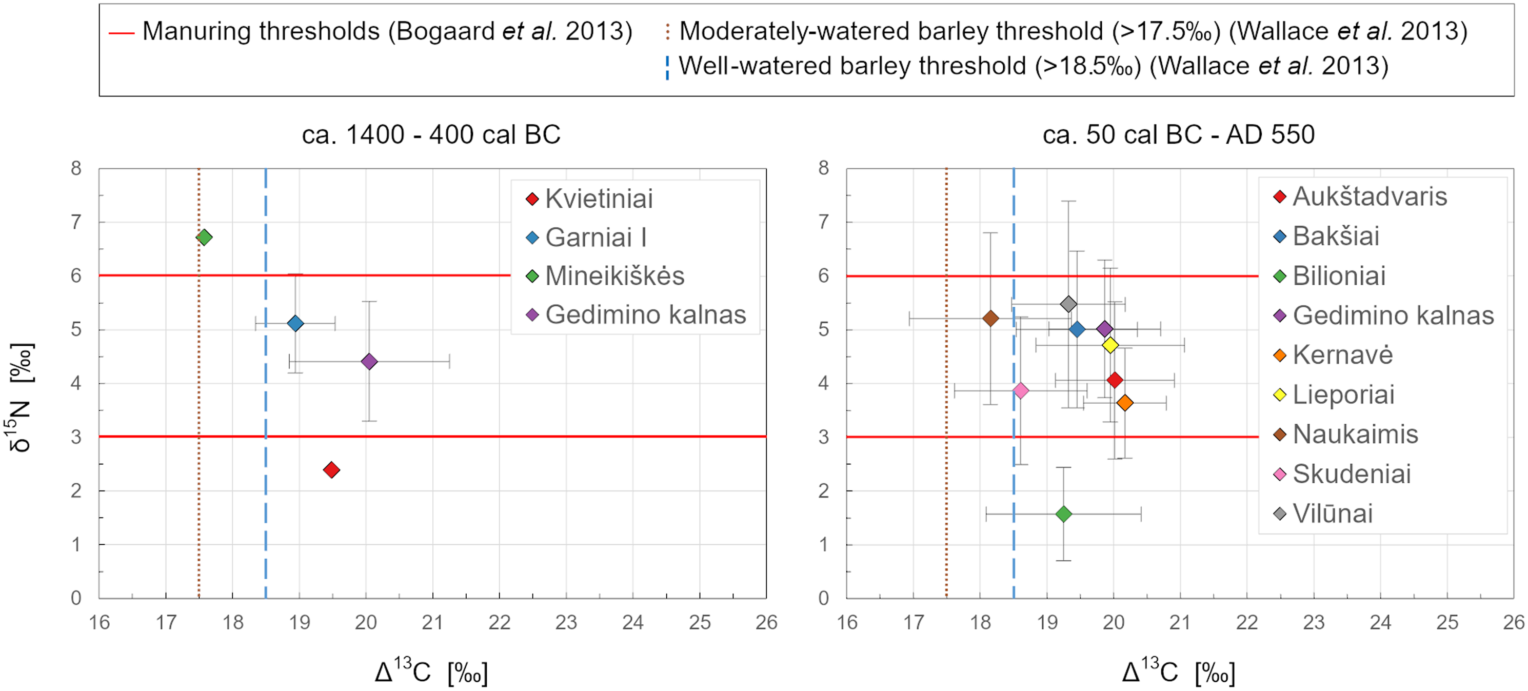
Archaeobotanically, higher concentrations of δ15N in plant tissue are associated with the use of organic nitrogen sources for soil fertilization (Fiorentino et al. Reference Fiorentino, Ferrio, Bogaard, Araus and Riehl2015). Thus, increased crop manuring is typically reflected in elevated δ15N values. Previous isotopic studies of Bronze Age barley—the primary cereal crop throughout prehistory in the southeastern Baltic—offer insight into potential shifts in manuring levels from the mid-2nd millennium BC through the Roman Iron Age (Figure 6). Mean δ15N values in Late Bronze Age barley grains range from 4.1‰ at Gedimino kalnas to 5.1‰ at Garniai I, with a notable single grain from Mineikiškės measuring as high as 6.7‰ (Minkevičius et al. Reference Minkevičius, Piličiauskienė, Podėnas, Micelicaitė, Kontrimas, Šapolaitė, Ežerinskis, Garbaras, Čivilytė, Luik and Tamulynas2023). These values fall within the ca. 3.0‰ to 6.0‰ range, typically associated with moderately manured crops (Bogaard et al. Reference Bogaard, Fraser, Heaton, Wallace, Vaiglova, Charles, Jones, Evershed, Styrink, Anderson, Arbogast, Bartosievicz, Gardeisen, Kanstrup, Maier, Marinova, Ninov, Schäfer and Stephan2013), and indicate a marked increase in manuring practices since the early Bronze Age, as seen in a barley grain from Kvietiniai, dated to 1409–1219 cal BC, with a δ15N value of 2.4‰ (Piličiauskas et al. Reference Piličiauskas, Vengalis, Minkevičius, Kisielienė, Ežerinskis, Šapolaitė, Skipitytė and Robson2021). By comparison, mean δ15N values in Roman Iron Age grains range from 2.4‰ at Kernavė to 5.5‰ at Vilūnai similarity suggests that manuring levels remained relatively stable from the Late Bronze Age through the Roman Iron Age.
Comparison of the mean δ15N and Δ13C values in barley grains from the Bronze Age and the Roman Iron Age assemblages (data from Minkevičius et al. Reference Minkevičius, Piličiauskienė, Podėnas, Micelicaitė, Kontrimas, Šapolaitė, Ežerinskis, Garbaras, Čivilytė, Luik and Tamulynas2023; Piličiauskas et al. Reference Piličiauskas, Vengalis, Minkevičius, Kisielienė, Ežerinskis, Šapolaitė, Skipitytė and Robson2021; this study).

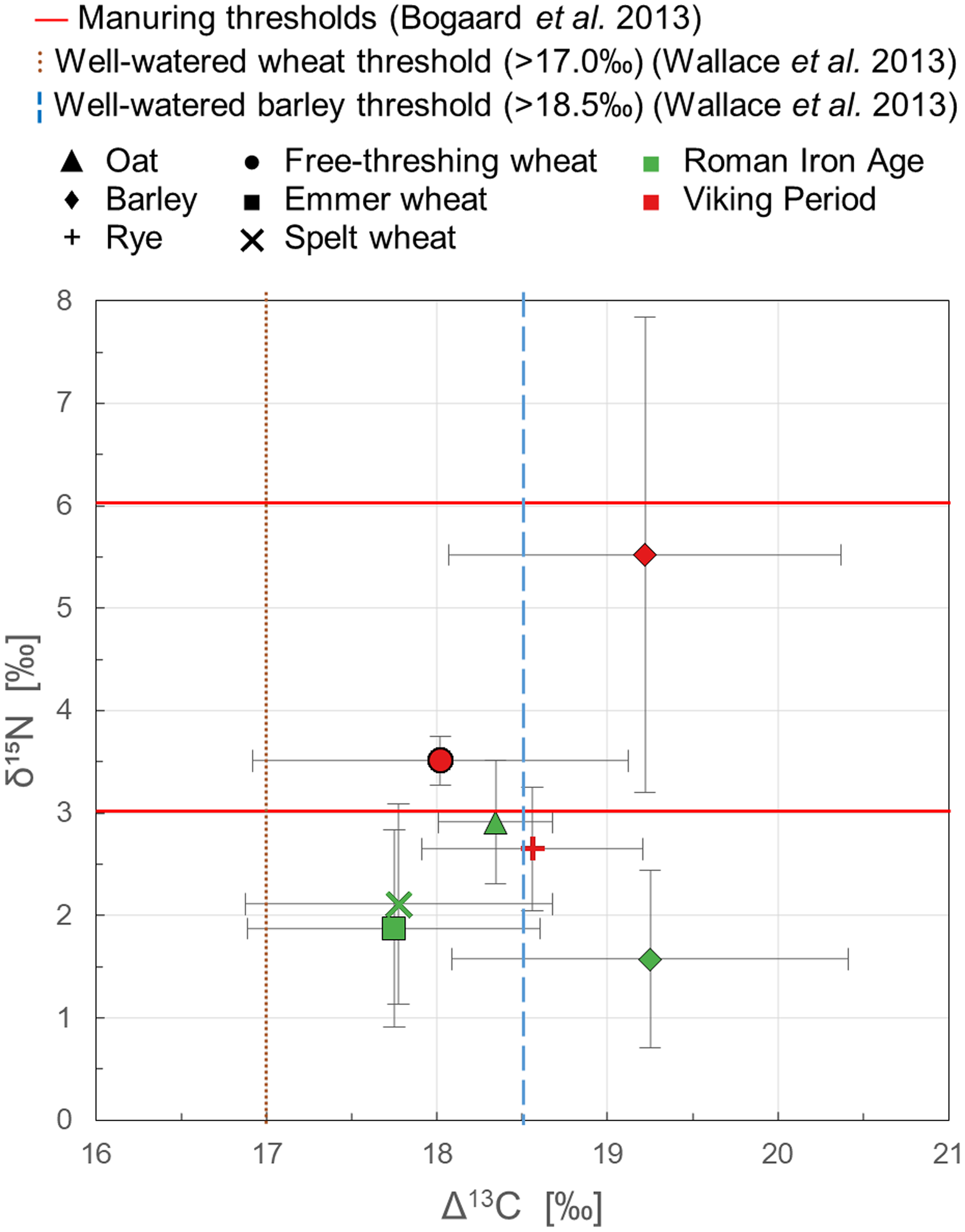
The single exception to the observed patterns occurs at Bilioniai, where mean δ15N values for Roman Iron Age barley are notably low, measuring just 1.6‰, well below the 3.0‰ threshold (Figure 7). This low δ15N trend appears across other species as well, with mean values of 2.9‰ for oat, 1.9‰ for emmer, and 2.1‰ for spelt. Such values imply these crops likely grew on unmanured soils, possibly indicating that the hilltop settlement was abandoned before a full agricultural cycle could establish. This could suggest either an absence of manuring or a land-use duration too brief for δ15N enrichment to appear in the grains (Fraser et al. Reference Fraser, Bogaard, Heaton, Charles, Jones, Christensen, Halstead, Merbach, Poulton, Sparkes and Styring2011). By contrast, isotopic data from charred grains in Viking Period deposits, dated to 898–1160 cal AD (Minkevičius Reference Minkevičius and Zabiela2019), show a marked shift. Mean δ15N values for this later period are 5.5‰ for barley, 2.7‰ for rye, and 3.5‰ for free-threshing wheat, indicating a clear rise in manuring levels over time.
Distribution of the mean δ15N and Δ13C values of cereals from the Roman Iron Age and Viking Period at Bilioniai hillfort.

A similar increase in manuring levels over time is observed at Gedimino kalnas. The mean δ15N value of barley increased by approximately 0.6‰, from 4.4 ± 1.1‰ in Late Bronze Age grains to 5.0 ± 1.3‰ in Roman Iron Age grains. The concentration of 15N increased even more notably in spelt, rising from 4.9 ± 0.6‰ (Minkevičius et al. Reference Minkevičius, Piličiauskienė, Podėnas, Micelicaitė, Kontrimas, Šapolaitė, Ežerinskis, Garbaras, Čivilytė, Luik and Tamulynas2023) to 7.1 ± 3.2‰. Although the scarcity of other wheat species limits direct comparison, it is also noteworthy that Late Bronze Age emmer yielded a mean δ15N value of 4.5 ± 0.5‰, while a grain of free-threshing wheat from the Roman Iron Age deposit measured 7.8‰. These findings indicate that 1st millennium AD cereals exhibit noticeably higher δ15N values than those of the earlier period, suggesting a gradually increasing use of manure over time.
The δ13C values in C3 plants correlate with photosynthetic activity and can be used to infer environmental factors such as water and sunlight availability (Bonafini et al. Reference Bonafini, Pellegrini, Ditchfield and Pollard2013; Wallace et al. Reference Wallace, Jones, Charles, Fraser, Halstead, Heaton and Bogaard2013). The mean Δ13C values of barley grains from the analyzed assemblages range from 18.6±1.0‰ at Skudeniai to 20.2±0.6‰ at Kernavė, exceeding the 18.5‰ threshold typically associated with well-watered barley (Wallace et al. Reference Wallace, Jones, Charles, Fraser, Halstead, Heaton and Bogaard2013). For wheat species, mean Δ13C values range from 18.0±1.5‰ to 18.3±1.0‰ at Skudeniai and from 18.4±0.9‰ to 20.3±0.7‰ at Kernavė, consistently surpassing the 17.0‰ threshold for well-irrigated wheat. This likely indicates a similar growing environment, considering the inter-species variation of 1–2‰ between wheat and barley. Naukaimis is the only site that slightly falls below the upper threshold, with a mean Δ13C value of 18.2±1.2‰ for barley and 16.8±0.5‰ for emmer, which may suggest limited water access or the influence of the “canopy effect.”
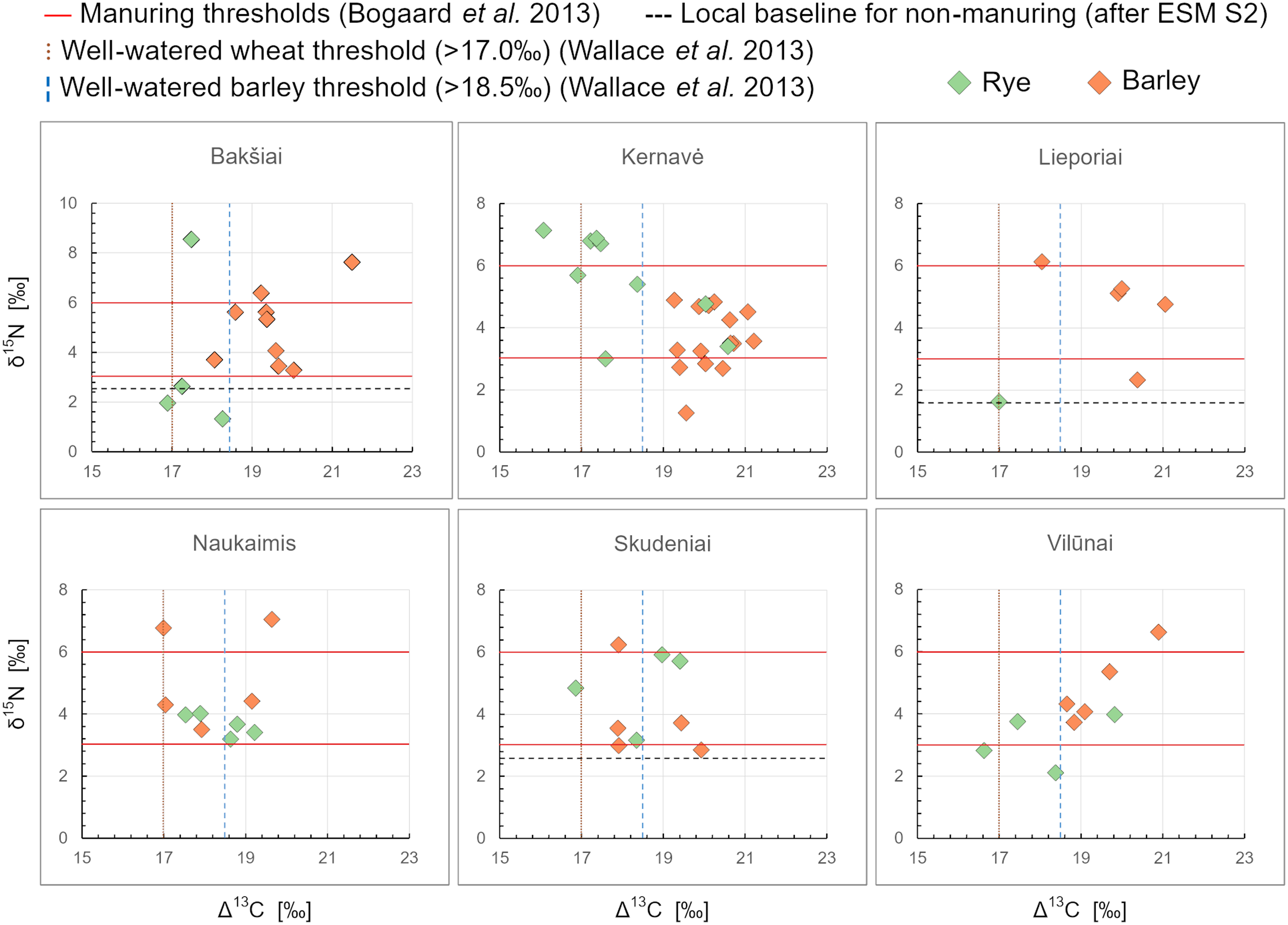
The comparison of nitrogen and carbon isotopic values in barley and rye grains reveals distinct differences in cultivation conditions between the two species (Figures 8 and 9). At Bakšiai, barley shows mean δ15N and Δ1 3C values of 5.0±1.5‰ and 19.5±0.9‰, respectively, suggesting moderate manuring (Bogaard et al. Reference Bogaard, Fraser, Heaton, Wallace, Vaiglova, Charles, Jones, Evershed, Styrink, Anderson, Arbogast, Bartosievicz, Gardeisen, Kanstrup, Maier, Marinova, Ninov, Schäfer and Stephan2013) and cultivation in an open, well-irrigated landscape (Wallace et al. Reference Wallace, Jones, Charles, Fraser, Halstead, Heaton and Bogaard2013). In contrast, rye values of 3.6±3.3‰ and 17.5±0.6‰ indicate considerable variability in nitrogen but consistently lower carbon values, pointing to cultivation in a different setting, possibly on poorer soils. A similar pattern appears at Lieporiai and Vilūnai. At Lieporiai, barley records δ15N and Δ1 3C values of 4.7±1.4‰ and 20.0±1.1‰, while the single rye grain measures distinctly lower at 1.6‰ and 17.0‰. Although based on one grain, this aligns with the broader trend. At Vilūnai, barley shows 5.5±1.9‰ (δ15N) and 19.3±0.9‰ (Δ1 3C), while rye is again lower at 3.2±0.9‰ and 18.0±1.2‰. Here, limited isotopic variability within each species further underscores potential differences in growing conditions. Interestingly, the Viking Period assemblage from Bilioniai shows the same pattern: barley has mean δ15N and Δ1 3C values of 5.5±2.3‰ and 19.2±1.2‰, while rye is consistently lower at 2.7±0.6‰ and 18.6±0.7‰. Barley displays greater variability in nitrogen values, but rye consistently records lower δ15N levels, suggesting that cultivation differences between these species persisted beyond the Roman Iron Age.
Crop stable isotope values from the sites analyzed in this study.

Stable isotope values of barley and rye grains from the Roman Iron Age assemblages.

However, it is important to note that this pattern applies only to certain assemblages. For instance, in Kernavė, the mean δ15N and Δ13C values for barley are 3.6±1.0‰ and 20.2±0.6‰, respectively, while for rye, they are 4.2±1.1‰ and 19.1±1.4‰. Similarly, at Naukaimis, the mean δ15N values are 5.2±1.6‰ for barley and 3.7±0.4‰ for rye, with mean Δ13C values of 18.2±1.2‰ and 18.4±0.7‰, respectively. At Skudeniai, the δ15N values for barley measure 3.9±1.4‰, with Δ13C values at 16.6±1.0‰, compared to rye values of 4.9±1.3‰ and 18.4±1.1‰. These data suggest that at these sites, both species were cultivated under similar conditions and regimes. This conclusion is further supported by the analysis of wild flora remains in the Kernavė assemblages, which indicate that all examined crops were likely cultivated in similar settings, perhaps on permanent fields within a floodplain (Minkevičius et al. Reference Minkevičius, Vengalis, Piličiauskienė, Poškienė, Pilkauskas and Vėlius2024). This suggests that while diversification of growing environments may have been advantageous at some sites, in others, the availability of fertile soils may have sufficed for cultivating both species in the same area.
While pollen records from Lithuania indicate increasing landscape openness during the Roman Iron Age (e.g., Daugnora et al. Reference Daugnora, Girininkas, Guobytė, Kisielienė, Simniškytė and Stančikaitė2004; Stančikaitė, Reference Stančikaitė2004; Stančikaitė et al. Reference Stančikaitė, Simniškytė, Skuratovič, Gedminienė, Kazkauskas and Uogintas2019), often linked to deforestation and slash-and-burn, our isotopic analysis suggests this change reflects expanding scope of agriculture rather than purely extensive farming. Elevated δ15N and Δ1 3C values in barley at most sites indicate moderate to intensive manuring, consistent with long-term cultivation of stable arable plots rather than shifting systems. This pattern implies that deforestation likely occurred during initial land clearance but was followed by the continuous field use rather than repeated slash-and-burn cycles.
In contrast, variable δ15N and lower Δ1 3C values in rye at certain sites suggest a distinct cultivation setting. Fertilization with mineral nitrogen alone would not elevate δ15N (Fiorentino et al. Reference Fiorentino, Ferrio, Bogaard, Araus and Riehl2015; Styring et al. Reference Styring, Rösch, Stephan, Stika, Fischer, Sillmann and Bogaard2017), and woodland cultivation could produce a “canopy effect” (Bonafini et al. Reference Bonafini, Pellegrini, Ditchfield and Pollard2013) lowering Δ1 3C—both consistent with swidden cultivation. Rye’s deep root system also makes it better suited to poorer or recently cleared soils, enabling yields where other cereals would struggle (Lazauskas Reference Lazauskas1980).
Taken together, these patterns suggest that while slash-and-burn was unlikely to dominate agricultural strategies, localized use of shifting cultivation remains plausible. This interpretation aligns with previous studies arguing that widespread reliance on extensive agriculture in prehistoric temperate Europe was unlikely (e.g., Danielisová et al. Reference Danielisová, Olševičová, Cimler, Machálek, Wurzer, Kowarik and Reschreiter2015; Jacomet et al. Reference Jacomet, Ebersbach, Akeret, Antolín, Baum, Bogaard, Brombacher, Bleicher, Heitz-Weniger, Hüster-Plogmann, Gross, Kühn, Rentzel, Steiner, Wick and Schibler2016), though the use of extensive outfields alongside permanent infields was a viable strategy, particularly where arable land was limited (Rowley-Conwy Reference Rowley-Conwy and Mercer1981).
The distinct isotopic signatures of barley and rye at certain sites further support the potential use of an “infield-outfield” system (Christensen Reference Christensen1978), where nutrient-demanding crops were intensively cultivated near settlements, and more remote outfields were used extensively for slash-and-burn or resource extraction. Although this pattern is observed only at some sites, it offers a valuable proxy for exploring the adoption of infield-outfield systems in temperate Europe, particularly along the Baltic coast where farmland was scarce.
Conclusions
The study provides the first stable carbon and nitrogen isotope measurements of charred crop macrofossils from the Roman Iron Age in the southeastern Baltic region. The results indicate a general continuity in manuring practices and landscape settings for cultivation from the Late Bronze Age until the mid-1st millennium AD. Some evidence suggests a gradual increase in manuring, though further analysis of archaeobotanical assemblages from long-term settlements is needed to confirm this trend.
Findings suggest that Roman Iron Age agriculture was primarily characterized by intensive farming on open, well-irrigated landscapes, while certain crops, especially rye, may have been cultivated in more distant swiddens with minimal fertilization. This supports the hypothesis of an infield-outfield cultivation system, where rye was introduced as part of a broader agricultural strategy across northern Europe. However, farming practices were not uniform across the region; isotopic data suggest a flexible approach, with local adaptations aimed at adaption to the local environment and risk mitigation.
Crucially, the new radiocarbon dates refine the chronology of these agricultural developments, suggesting that rye—one of the key innovations—may have been introduced to Lithuania as early as the 1st to mid-2nd century AD, earlier than previously thought. Its distribution suggests a spread from southern Lithuania along the Nemunas River, revealing a previously overlooked route for agricultural innovation. The radiocarbon data also indicate that these changes unfolded gradually across the region, rather than through rapid, uniform adoption.
Supplementary material
To view supplementary material for this article, please visit https://doi.org/10.1017/RDC.2025.10118
Acknowledgments
We extend our sincere thanks to the staff of the Archaeological Site Museum of Kernavė, the National Museum of Lithuania, and Vytautas the Great War Museum for their invaluable support. In particular, we are deeply grateful to Asta Vasiliauskaitė for her guidance and assistance throughout this study. This research is part of the project “Agrarian Landscapes of the Roman Period: Interactions Between Agriculture and the Environment in 1st–4th c. AD Lithuania”, funded by the Research Council of Lithuania (LMTLT), agreement No. [S-PD-22-74].
Competing interests
The authors have no competing interests to declare that are relevant to the content of this article.