INTRODUCTION
Playas, or ephemeral lakes, form in arid and semiarid lands where precipitation is highly seasonal and evapotranspiration rates exceed moisture availability (Briere, Reference Briere2000). With an estimated 50,000 playas worldwide (Neal, Reference Neal1975), playa deposits have the potential to serve as archives of past climatic and environmental change at a variety of temporal and spatial scales (Bowler et al., Reference Bowler, Qi, Kezao, Head and Baoyin1986; Yechieli and Wood, Reference Yechieli and Wood2002; Fuchs and Buerkert, Reference Fuchs and Buerkert2008; Ginau et al., Reference Ginau, Engel and Brückner2012). Playa deposits are not used as paleoclimatic proxies very often, however, in part because the sediments can be exceptionally difficult to date. Playa deposits typically contain low concentrations of organic material because of limited vegetation in the drainage basin and highly oxidizing conditions within the playa, making 14C dating of organic material difficult (Bowler et al., Reference Bowler, Qi, Kezao, Head and Baoyin1986). This has led some researchers to explore dating inorganic carbonates (authigenic calcite) found within playa sediments, although the results are often equivocal because of diagenetic alteration, contamination by detrital carbonates, and open-system behavior with respect to carbon (Bowler et al., Reference Bowler, Qi, Kezao, Head and Baoyin1986). More promising results have been obtained using optically stimulated luminescence (OSL) techniques (e.g., Fuchs and Buerkert, Reference Fuchs and Buerkert2008), but this typically requires trenching of playa sediments, as well as the additional time and expense associated with the OSL analytical work.
The Middle East is one region where paleoclimatic proxy records from playa deposits could have a profound impact on understanding past and future climate change. Although a few well-dated and continuous paleoclimatic proxy records in the Levant and Arabian Peninsula provide important information regarding past environmental conditions, there are large areas—including most of Jordan—where well-dated paleoclimatic records are rare and there is little consensus among the published results (Davies, Reference Davies2005). Well-established records from the Dead Sea (Bartov et al., Reference Bartov, Stein, Enzel, Agnon and Reches2002, Reference Bartov, Goldstein, Stein and Enzel2003; Lisker et al., Reference Lisker, Vaks, Bar-Matthews, Porat and Frumkin2010; Torfstein et al., Reference Torfstein, Goldstein, Stein and Enzel2013, Reference Torfstein, Goldstein, Kushnir, Enzel, Haug and Stein2015) and speleothems from throughout the Levant (e.g., Bar-Matthews et al., Reference Bar-Matthews, Ayalon, Kaufman and Wasserburg1999, Reference Bar-Matthews, Ayalon, Gilmour, Matthews and Hawkesworth2003; Vaks et al. Reference Vaks, Bar-Matthews, Ayalon, Schilman, Gilmour, Hawkesworth, Frumkin, Kaufman and Matthews2003, Reference Vaks, Bar-Matthews, Ayalon, Matthews, Frumkin, Dayan, Halicz, Almogi-Labin and Schilman2006, Reference Vaks, Bar-Matthews, Matthews, Ayalon and Frumkin2010; Bar-Matthews, Reference Bar-Matthews2014) provide invaluable paleoenvironmental data, but using isolated records such as these to infer climatic change over broad areas may result in overgeneralized climatic reconstructions that miss complexities that are important on local and regional scales (Rosen, Reference Rosen2007; Enzel et al., Reference Enzel, Amit, Dayan, Crouvi, Kahana, Ziv and Sharon2008; Rambeau, Reference Rambeau2010). As endorheic basins with playas cover approximately 40% of Jordan’s eastern desert (Davies, Reference Davies2005) and are widespread over many other regions of the Middle East, these depositional environments have great potential for reconstructing past environmental changes over broad spatial scales, but only if they can be dated reliably.
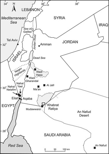
Here, we present a paleoclimatic proxy record from Khabrat Ratiya, a dry playa in the Mudawwara depression of southern Jordan (Fig. 1). This region is important for understanding past climate dynamics as some researchers have argued that it was too far south to be influenced by westerly precipitation from the Mediterranean (Enzel et al., Reference Enzel, Amit, Dayan, Crouvi, Kahana, Ziv and Sharon2008), whereas others have argued that this region was under the influence of tropical monsoonal precipitation in the recent geologic past (Abed et al., Reference Abed, Yasin, Sadaqa and Al-Hawari2008; Petit-Maire et al., Reference Petit-Maire, Carbonel, Bourrouilh, Reyss, Fontugne, Sanlaville, Abed, Bourrouilh, Fontugne and Yasin2010). Understanding climatic and environmental change in southern Jordan is also important for assessing the suitability of the area for human migration between the Arabian Peninsula and southern Levant during the late Pleistocene (e.g., Parker, Reference Parker2009).
Location of the study area in southernmost Jordan along with key paleoclimatic proxy records in the southern Levant and northern Arabian Peninsula. Shaded areas in southern Jordan represent the Wadi Hasa catchment and the Mudawwara basin within Jordan.

In 2012, we collected a 2.35 m sediment core from Khabrat Ratiya. We determined the physical, chemical, and mineralogical properties and radiocarbon dated concentrated organic matter from the playa sediments to establish a chronological framework. The resulting ages and reconstructed depositional environment allow us to evaluate the timing and causes of past intervals of relatively wet conditions in southern Jordan and the surrounding areas during the late Pleistocene.
STUDY AREA
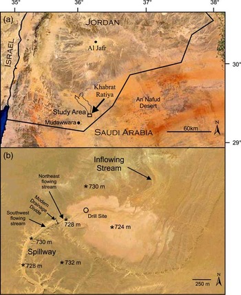
The Mudawwara depression (i.e., sedimentary basin) is located in southern Jordan and northwestern Saudi Arabia (29°N, 36°E; Fig. 1 and 2a). The depression covers >700 km2 and ranges in elevation from ~860 m above sea level (asl) in the north to ~675 m asl in the center of the basin near the Jordan–Saudi Arabia border. The area exhibits little topographic relief, with a total range in elevation of <200 m. The depression contains several small endorheic basins, including the dry playa Khabrat Ratiya, located at 29°22.02’N, 36°10.92’E near the northeastern margin of the Mudawwara depression (Masri, Reference Masri1988) (Fig. 1 and 2a). The playa is small (<1 km2), with a topographic low of ~724 m asl in the center of the playa and margins that are at ~732 m asl. The area of the modern drainage basin for the playa is ~330 km2 and ranges in elevation from ~1040 m asl to the north down to ~724 m asl. The bedrock lithology exposed throughout the drainage basin, including below the playa sediments, consists of Silurian marine Ratiya Sandstone (Masri, Reference Masri1988). In the area of Khabrat Ratiya, the silty mudstone facies of the Ratiya Sandstone is present (Masri, Reference Masri1988). Today the playa does not appear to be active as the modern drainage has incised several meters into the surrounding playa deposits.
(color online) Study area. (a) Satellite image showing the location of Khabrat Ratiya playa, its catchment (dashed line), and the Mudawwara region (29°22.02’N, 36°10.92’E) in southern Jordan. (b) Satellite image of Khabrat Ratiya (29°22.02’N, 36°10.92’E) with drill site and drainages marked. Primary drainage that flows into the playa is located on the north side of the basin, and the inactive spillway is situated on the western margin. The northeastern portion of the spillway flows into the playa today, whereas just to the southwest there is a drainage divide. Asterisks indicate spot elevations derived from Google Earth.

The nearest long-term precipitation stations in southern Jordan are located in the cities of Ma’an and Al Jafr, located ~100 km to the north/northwest for Ma’an and 100 km to the north for Al Jafr at elevations of 1120 m and 860 m, respectively (Fig. 1). Over the last 50 yr, Ma’an has received on average 41.3 mm/yr precipitation, and Al Jafr has received 30.3 mm/yr, most of which falls between October and April (Ghanem, Reference Ghanem2013; Jordan Meteorological Department [JMD], 2016). As Mudawwara is to the south and at a lower elevation, it likely receives <30 mm/yr. Mean air temperature for these stations averages ~18°C, with winter temperatures averaging ~6 to 10°C and summer temperatures averaging ~23 to 27°C (JMD, 2016). Modern vegetation in the Mudawwara region is sparse and located primarily in ephemeral streams or wadis. Well data show that the local water table is ~20 m below the surface in Mudawwara (Fig. 1), where numerous central-pivot irrigation fields for agriculture have been developed, and drops eastward reaching ~115 m below the surface ~20 km east of the township (Water Authority of Jordan, 2013). By extrapolation, the depth to the water table at Khabrat Ratiya is probably ~55 m. Playas in eastern Jordan, including Khabrat Ratiya, may go several years without receiving any rainfall in the catchment (Davies, Reference Davies2005), although standing water can occupy playas for up to several months following wet winter seasons (Rech et al., Reference Rech, Quintero, Wilke and Winer2007).
Khabrat Ratiya was chosen for study because there is a large drainage, or spillway, emanating from western side of the playa (Fig. 2b). The spillway is not active today as evidenced by a drainage divide that is present, with water flowing toward the playa to the north of the divide and away from the playa south of the divide (Fig. 2b). Although the playa is not known to overflow under current climatic conditions, the presence of this spillway suggests that there could have been a perennial lake at this locality in the past, or, alternatively, that the playa filled with water and discharged out of this spillway episodically (Fig. 2b). Regardless, there is a reasonable chance that sediments in the closed basin could provide a record of past climatic conditions in what is now a hyperarid environment.
METHODS AND MATERIALS
A 7 cm, air-cooled rotary drill was used to collect a 2.35 m continuous core (KR-A) to bedrock from the northwestern sector of Khabrat Ratiya (29°22.14’N, 36°10.62’E) at an elevation of ~728 m asl (Fig. 2b). The majority of the sediment core was retrieved intact. Most of the sediments were wrapped in plastic, placed in core boxes, and separated into ~3 cm sections. A few parts of the core were unconsolidated when removed and so were placed in bags and labeled as mixed from the appropriate depths. We attempted to drill at several other localities within the playa, but the sediments were less consolidated and recovery was poor. At all localities, bedrock was encountered at depths of 2 to 3 m. Physical features of the core, including color, mottling, bioturbation, and mud cracks, were described, and samples were submitted for mineralogical and geochemical analyses, characterization by scanning electron microscopy, and radiocarbon dating.
Physical and chemical analyses
Bulk mineralogy was determined on five samples (depths 5, 80, 160, 195, and 235 cm) from the extracted core with a Scintag X1 Powder Diffractometer (40 kV, 35 mA, CuKα radiation) using a fixed slit scintillation detector and scan range of 2°–70° 2-theta. Materials Data Inc. Jade 7 software was used to infer mineralogy. Mineralogical micromorphology and grain-size analysis were carried out on uncoated, freshly broken surfaces using a Zeiss field-emission scanning electron microscope (SEM) equipped with an energy-dispersive X-ray (EDX) detector. Secondary electron images were captured with a 2 keV acceleration voltage. EDX chemical analysis of minerals was performed using a 20 keV acceleration voltage and 8.5 mm working distance.
Particle-size distributions were determined for 14 samples at 20 cm depth intervals using a Malvern 2000 Laser Particle Size Analyzer. Carbonate and soluble salts were removed from all samples, and sodium hexametaphosphate was used as a deflocculant prior to particle-size analysis. The sediment samples were also analyzed for soluble salts by dissolving the salts in water and then analyzing the decanted solution on a Dionex DX-500 High-performance liquid chromatography ion chromatograph. Cations were measured against three external solution standards made from 1 mg/mL inductively coupled plasma (ICP) standards on an Agilent 720ES axial-viewing ICP-Optical emission spectrometry (OES) using Be and In as internal standards. Samples at 10 cm depth intervals were analyzed for organic carbon and nitrogen using a Flash 2000 NC Soil Analyzer (CE Elantech). The δ13C and δ 18O isotopic values of carbonate minerals were analyzed at the Environmental Isotopes Laboratory, University of Waterloo, and are reported in delta (δ) notation using Vienna Pee Dee belemnite as the standard. Finally, percent carbonate was estimated from the amount of CO2 produced by reacting the samples with 100% phosphoric acid during isotopic analysis.
Radiocarbon dating of playa sediments
Five samples for radiocarbon dating were chosen from playa sediments at intervals that had the highest concentrations of organic C (~0.11 to 0.13%). At each interval, large (~250 g) mineral-rich samples were soaked in deionized (DI) water overnight and screened at 150 µm using copious amounts of DI water to remove coarse sand and gravel. Samples were stirred in beakers and given 3 to 5 seconds to settle, and then the supernatant liquid containing the majority of the organic material was poured into 50 mL centrifuge tubes. This procedure was designed to remove particles that are denser than typical organic material and reduces the mineral content of the samples without losing many of the organic particles, thereby reducing the amount of acid used in subsequent steps. Samples were then centrifuged for several minutes to isolate particles larger than 8 µm in diameter, and the supernatant was discarded. This was repeated until the supernatant was clear.
The resulting 8-150 μm fraction was treated initially with 10% HCl and allowed to react until the reaction was visually complete. The samples were then centrifuged, decanted, and treated with 6N HCl overnight to ensure complete removal of all carbonate minerals. After rinsing, centrifuging, and decanting again, a small amount (5 mL, to prevent a violent reaction) of HF (48%) was added and stirred using a vortex mixer to begin removing siliciclastic minerals. After 1 hour, additional HF was added slowly to the sample, and the solution was allowed to react for at least 12 hours. The acidic solution was then decanted after centrifugation, and HF was reintroduced to the tubes, mixed on the vortex mixer, and placed in a hot water bath at ~80°C for approximately 4 hours to further remove silicates. The samples were once again centrifuged and decanted, and 6N HCl was reintroduced to the sample to prevent fluorine precipitation. Finally, the samples were centrifuged, decanted, and rinsed repeatedly until the pH of the supernatant fluid was neutral. The organic-rich material was placed in glass vials, visually inspected under a microscope to assess the nature of the organic material, and dried overnight at 60°C.
The goal of this process was to remove carbonate and siliciclastic materials and concentrate the organic matter. This allows the combustion, CO2 extraction, purification, and graphitization steps to proceed without the difficulties of small-sample analyses and also permits the direct application of standard and blank corrections (e.g., Donahue et al., 1990). A secondary effect of the processing is that labile and partially degraded organics are removed during the pretreatment process, further concentrating the targeted carbon pool. Previous efforts that have used this technique on lacustrine and wetland sediments have shown that 14C ages of concentrated organic material are statistically indistinguishable from ages derived from plant macrofossils at the same stratigraphic horizon (Pigati et al., Reference Pigati, Reheis, McGeehin, Honke and Bright2016). We note that in the case of the Khabrat Ratiya samples, the concentrated organic material was not subjected to the usual base and final acid treatments as it was thought that this would destroy the remaining material. However, given the paucity of vegetation at the site, the potential effect of contamination by humic acids or other base-soluble organic compounds is likely minimal.
The concentrated organic matter was submitted to Aeon Laboratories LLC for combustion, purification, graphitization, and dating by accelerator mass spectrometry (AMS). The resulting 14C ages were calibrated using the IntCal13 data set and CALIB 7.1html (Stuiver and Reimer, Reference Stuiver and Reimer1993; Reimer et al., Reference Reimer, Bard, Bayliss, Beck, Blackwell, Bronk Ramsey and Buck2013). Ages are presented in calibrated 14C yr BP (ka, thousands of years; BP, before present; 0 yr BP, AD 1950) and uncertainties are given at the 95% (2σ) confidence level.
RESULTS
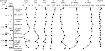
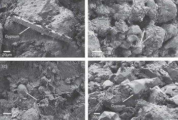
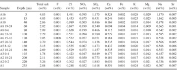
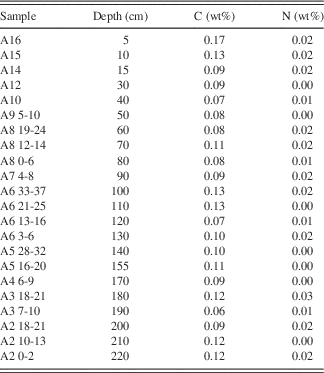
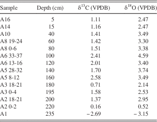
The upper 2.1 m of the sediment core is relatively homogenous, massive, and reddish yellow in color (Munsell 7.5YR 6/6). Desiccation cracks, root voids, and evidence of bioturbation are common. In the uppermost 1.5 m, the particle-size distribution is ~30% clay, 40% silt, and 30% sand, with a slight increase in silt and a decrease in sand between 1.5 and 2.1 m (Fig. 3). Mineralogical and geochemical analysis of the sediments did not identify any significant differences throughout the uppermost 2.1 m of the core. X-ray diffraction analysis of bulk sediments showed that the mineralogy was predominantly quartz and kaolinite, with a lesser abundance of calcite. SEM results showed detrital quartz grains and clays and identified secondary precipitation of calcite and halite, along with lesser amounts of gypsum (Fig. 4). Sulfate and chloride salts were both present down to 2.1 m, with total soluble salt concentrations ranging between ~1.8 and 4.8% (Table 1). Organic carbon ranged from 0.06 to 0.17%, and nitrogen ranged from 0 to 0.03% (Table 2). Finally, the δ13C and δ18O isotopic values of calcite from this part of the core ranged between 0.16 and 2.58‰ for δ13C and between 0.52 and 4.59‰ for δ18O (Table 3).
Description of sediment core KR-A from Khabrat Ratiya with 14C ages, particle-size analysis, geochemistry, isotopic analyses of carbonate minerals, and organic C content. VPDB, Vienna Pee Dee belemnite.

Scanning electron microscopy images of detrital grains and authigenic precipitates within the Khabrat Ratiya sediment core. (a) Secondary gypsum at a depth of 15 cm. (b) Secondary halite at 220 cm. (c) Quartz grains at 160 cm. (d) Secondary gypsum at 80 cm.

Soluble salts.

Organic carbon and nitrogen.

Stable isotopes. VPDB, Vienna Pee Dee belemnite.

Sediments between 2.1 and 2.35 m are different from the overlying deposits, exhibiting a lighter color (light yellowish brown; 10YR 6/4) and coarser particle size (~50% sand) than the majority of the overlying sediments (Fig. 3). The deposits at this depth interval are also massive but lack evidence of mud cracks and root voids. In addition, calcite had lower isotopic values than the overlying sediments, with a δ13C value of −2.69‰ and a δ18O value of −3.15‰ (Table 3).
Finally, organic carbon concentrations of the five samples processed for 14C dating using the techniques described previously ranged between 7.0 and 10.4%, an increase of approximately two orders of magnitude over the initial concentrations. The majority of the concentrated organic matter appears to be degraded pollen grains and plant detritus based on visual inspection under a microscope. Calibrated 14C ages for these samples ranged from 21.34 ± 0.30 ka at a depth of 10 cm to 28.40 ± 0.33 ka at a depth 180 cm, with one sample (taken at 210 cm) yielding a stratigraphically inconsistent age of 23.73 ± 0.27 ka (Table 4).
Radiocarbon ages. AMS, accelerator mass spectrometry; VPDB, Vienna Pee Dee belemnite.

a Depth from surface.
b Calibrated ages were calculated using CALIB v. 7.1html, IntCal13.14C data set; limit 50.0 calendar ka BP. Calibrated ages are reported as the midpoint of the calibrated range. Uncertainties are reported as the difference between the midpoint and either the upper or lower limit of the calibrated age range, whichever is greater. Multiple ages are reported when the probability of a calibrated age range exceeds 0.05.
c P is the probability of the calibrated age falling within the reported range as calculated by CALIB.
DISCUSSION
Depositional environment
The reddish color, low organic carbon, mud cracks, root voids, and secondary soluble salts of the Khabrat Ratiya deposits are indicative of a dry playa environment, similar to conditions at the site today. The high δ18O and δ13C values of carbonate minerals are also comparable to values in other dry playas where evaporative enrichment and kinetic effects are common (e.g., Sinha et al., Reference Sinha, Smykatz-Kloss, Stüben, Harrison, Berner and Kramar2006). The variations in stable isotopes, particle-size distributions, and salt concentrations may be attributed to slight differences in precipitation, runoff and erosion, and seasonal evaporation over time. Calcite in the lowest 25 cm of the core displayed lower isotopic values, and the sediment was coarser and more yellow in color than in the rest of the core, with mottled zones of iron oxides. These differences are most prevalent near the basal contact of the playa deposits with the underlying marine Ratiya Sandstone bedrock and may be in part the result of mixing between the partially weathered bedrock and playa sediments. The differences may also be the result of a slightly different geochemical environment at this contact zone where water becomes perched on top of the underlying, impermeable bedrock.
Despite the spillway emanating from the western margin of the lake, there is no evidence for a perennial lake system at Khabrat Ratiya in the recent geologic past. The spillway indicates that the dry lake filled periodically with water and overflowed through the drainage. The width of the spillway channel, and the meandering nature of the channel both above and below the playa, suggest that this drainage is not a classic paleolake spillway, but rather is likely a continuation of the stream that enters the playa to the north that has been displaced by active faulting (Masri, Reference Masri1988).
Radiocarbon ages
Several lines of evidence suggest that the ages of the four uppermost concentrated organic matter samples from the Khabrat Ratiya core are robust. First, there is internal stratigraphic consistency for these four 14C ages with the oldest age at the bottom and the youngest age on top. Second, although there is a wide range in the deposition rates of playas, the average deposition rate from Khabrat Ratiya of ~25 cm/ka is comparable to deposition rates for playas elsewhere in the region (Davies, Reference Davies2005). Finally, as stated previously, calibrated 14C ages from concentrated organic matter using the techniques employed here were essentially the same as calibrated 14C ages from plant macrofossils from the same stratigraphic horizon at a site located in a similar environment in the Mojave Desert of southern California, USA (Pigati et al., Reference Pigati, Reheis, McGeehin, Honke and Bright2016). The cause for the anomalously young age at a depth of 2.1 m may be the result of humic acids that were mobilized during periods of standing water in the basin as this sample is just 25 cm above the impermeable bedrock. Water that infiltrates the playa sediments would have been perched on this aquiclude, allowing the transport of, and contamination by, younger humic acids by the infiltrating water.
Comparison to other hydrologic proxy records from the region
In arid environments, erosion rates are highest when precipitation events are frequent and intense enough to induce overland flow and erosion, but not frequent enough to support perennial vegetation that covers the landscape and limits erosion (Molnar, Reference Molnar2001). Today, the region of Mudawwara is hyperarid, receiving only <30 mm/yr precipitation. The landscape is devoid of perennial vegetation, except for isolated patches sustained by shallow groundwater, and large precipitation events are rare. Based on the reconstructed environment and chronometric ages discussed previously, activation of the Khabrat Ratiya playa at ~29–21 ka was likely the result of more frequent and intense precipitation events within the catchment basin causing enhanced erosion of the surrounding area and increased sedimentation rates in the playa. Reduced temperatures may have played a secondary role, reducing evapotranspiration during precipitation events and allowing shallow water to persist within Khabrat Ratiya playa for longer periods of time, but increased precipitation and runoff during this time was necessary to erode sediments from the catchment area and deposit them within the playa. It is also probable that enhanced westerly winds, dustier atmospheric conditions, and exposed coastal environments along the Mediterranean during last full glacial period (Ben David, Reference Ben David2003; Enzel et al., Reference Enzel, Amit, Dayan, Crouvi, Kahana, Ziv and Sharon2008; Crouvi et al., Reference Crouvi, Amit, Enzel and Gillespie2010) led to increased availability of silt across the catchment area of Khabrat Ratiya at this time. Regardless, enhanced precipitation was needed to mobilize this sediment and transport it through ephemeral discharge events.
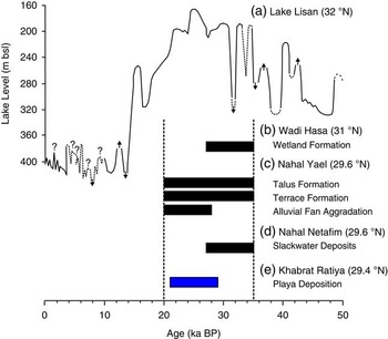
Evidence of enhanced erosion and sedimentation during the last full glacial period is also found at several sites in the southernmost Levant, including Lake Lisan (32°N), Wadi Hasa (31°N), Wadi Gharandal (31°N), Nahal Yael (29.6°N), and Nahal Netafim (29.4°N) (Fig. 1). The lake level record of Paleolake Lisan in the Dead Sea basin is one of the key paleoclimatic proxy records of climate change for the past 130,000 yr in the southern Levant (Bartov et al., Reference Bartov, Stein, Enzel, Agnon and Reches2002, Reference Bartov, Goldstein, Stein and Enzel2003; Torfstein et al., Reference Torfstein, Goldstein, Stein and Enzel2013, Reference Torfstein, Goldstein, Kushnir, Enzel, Haug and Stein2015). Today, the Dead Sea is <420m below sea level (bsl), but effective moisture was high enough in the catchment from ~70 to 13 ka to raise and sustain a large paleolake, Paleolake Lisan (Stein and Goldstein, Reference Stein and Goldstein2006). During this time, lake levels were 150 to 240 m higher than modern levels (Bartov et al., Reference Bartov, Stein, Enzel, Agnon and Reches2002; Torfstein et al., Reference Torfstein, Goldstein, Stein and Enzel2013). The main high lake phase of Lake Lisan was from ~35 to 21 ka (Fig. 5). Significant drops in lake level occurred at ~33 and 31 ka, but the lake was high (>200 m bsl) and stable from 30 to 21 ka. The lake peaked at ~167 m bsl from ~27 to 25 ka, when Paleolake Lisan and the Sea of Galilee merged into one large paleolake (Hazan et al., Reference Hazan, Stein, Agnon, Marco, Nadel, Negendank, Schwab and Neev2005).
(color online) Paleoclimatic proxies from the southern Levant during the late glacial period. (a) Lake level fluctuations of Paleolake Lisan (Bartov et al., Reference Bartov, Stein, Enzel, Agnon and Reches2002; Torfstein et al., Reference Torfstein, Goldstein, Stein and Enzel2013). (b) Wetland formation in Wadi Hasa (Winer, Reference Winer2010; Rech et al., Reference Rech, Ginat, Catlett, Mischke, Tully and Pigati2017). (c) Main aggradation phase of talus sediments, fluvial terraces, and alluvial fan sediments in Nahal Yael (Enzel et al., Reference Enzel, Amit, Grodek, Ayalon, Lekach, Porat, Bierman, Blum and Erel2012). (d) Slack-water deposits associated with large floods in Nahal Netafim (Greenbaum et al., Reference Greenbaum, Porat, Rhodes and Enzel2006). (e) Activation of Khabrat Ratiya playa (this study). m bsl, meters below sea level.

In the Hasa catchment in central Jordan, groundwater discharge and in-stream wetland deposits also indicate much wetter conditions during the last full glacial period than today (Winer, Reference Winer2010; Rech et al., Reference Rech, Ginat, Catlett, Mischke, Tully and Pigati2017). There, the age of the most widespread wetland unit (unit C) is well constrained with calibrated AMS 14C ages on organic material and archaeological charcoal dating to ~35–27 ka (Fig. 5). Unit C deposits represent greater groundwater discharge and wetter climatic conditions at this time (Winer, Reference Winer2010; Rech et al., Reference Rech, Ginat, Catlett, Mischke, Tully and Pigati2017). Wetland deposits have also been identified in Wadi Gharandal, where a radiocarbon and an OSL age indicate that water tables there were elevated at ~32 ka, but the duration of wetland formation at this locality is not well constrained (Mischke et al., Reference Mischke, Ginat, Faerstein, Porat, Braun, Rech and Al-Saqarat2017).
In the Nahal Yael catchment, a small (0.5 km2) watershed just north of Eilat, ~120 km to the west/northwest of Khabrat Ratiya playa, the main period of talus formation and alluvial aggradation as determined by OSL dating occurred between ~35 and 20 ka (Enzel et al., Reference Enzel, Amit, Grodek, Ayalon, Lekach, Porat, Bierman, Blum and Erel2012) (Fig. 5). Similarly, in the adjacent Nahal Netafim catchment (~35 km2), slack-water deposits associated with large floods were identified in a cave ~1.5 to 5 m above the modern channel. These deposits, dated with infrared-stimulated luminescence, were laid down between ~35 and 27 ka (Greenbaum et al., Reference Greenbaum, Porat, Rhodes and Enzel2006; Enzel et al., Reference Enzel, Amit, Grodek, Ayalon, Lekach, Porat, Bierman, Blum and Erel2012) (Fig. 5). We note that the termination of the slack-water deposits at ~27 ka appears to be associated with a complete filling of the cave with sediments rather than the termination of large floods, so exactly when the wet conditions ended here is unclear.
In Al Jafr basin (~30°N), a large (1000–1800 km2) freshwater lake was proposed to have existed during the late Pleistocene based on the widespread exposure of green and white marls (Huckriede and Wiesemann, Reference Huckriede and Wiesemann1968). The authors inferred the lake to have existed during the last glacial period based on archaeological materials and one 14C age of 25,000 14C yr on bulk carbonate (Huckriede and Wiesemann, Reference Huckriede and Wiesemann1968). Subsequent work, however, has demonstrated that these deposits are wetland and not lake deposits, and that the deposits are >40,000 yr old (Enzel et al., Reference Enzel, Amit, Dayan, Crouvi, Kahana, Ziv and Sharon2008; Mischke et al., Reference Mischke, Opitz, Kalbe, Ginat and Al-Saqarat2015, Reference Mischke, Ginat, Faerstein, Porat, Braun, Rech and Al-Saqarat2017; Rech et al., Reference Rech, Ginat, Catlett, Mischke, Tully and Pigati2017). Although the deposits indicate more pluvial conditions existed in the past, the unknown age of the deposits limits their significance as a paleoclimatic proxy.
The An Nafud Desert in northwest Saudi Arabia is situated just to the southeast of Khabrat Ratiya (Fig. 1). Lacustrine or paludal deposits were first described in this region in the 1980s (Whitney and Gettings, Reference Whitney and Gettings1982; Whitney et al., Reference Whitney, Faulkender and Rubin1983; Schulz and Whitney, Reference Schulz and Whitney1986). Marls, diatomites, and green mudstones along with a diverse array of aquatic fauna indicate widespread freshwater habitats existed in this region in the recent geologic past. Similar to the Al Jafr basin, these deposits were originally thought to date mostly to the full glacial period (~34–24 ka) based on radiocarbon ages on bulk carbonate, but subsequent OSL dating demonstrated that the deposits likely range in age from 400 to 100 ka (Rosenberg et al., Reference Rosenberg, Preusser, Risberg, Plikk, Kadi, Matter and Fleitmann2013). This is similar to other localities in Saudi Arabia where radiocarbon dates on bulk carbonates of 40–25 ka were found to be erroneous (Rosenberg et al., Reference Rosenberg, Preusser, Fleitmann, Schwalb, Penkman, Schmid, Al-Shanti, Kadi and Matter2011).
Overall, paleoclimatic proxy records from multiple sites in the region surrounding Khabrat Ratiya indicate that during the last full glacial period, from ~35 to 20 ka, erosion and sedimentation rates were higher and enhanced groundwater recharge rates raised local or regional water tables at various locations in the southernmost Levant. It is difficult to quantify the increase in precipitation that occurred in the region during that time, although it was certainly greater than modern levels (~20 to 50 mm/yr) and probably less than 300 mm/yr based on the lack of speleothem formation in the Negev (Vaks et al., Reference Vaks, Bar-Matthews, Matthews, Ayalon and Frumkin2010).
Paleoclimatic implications
The coincidence in timing between the activation of Khabrat Ratiya playa and wet conditions recorded in other paleoclimatic proxies in the region suggests that there were changes in the climate system during last full glacial period that caused enhanced rainfall throughout the southernmost Levant. An understanding of the modern synoptic climatology of this region, in conjunction with the timing and spatial distribution of pluvial deposits established here, allows us to speculate on the past climatological conditions that may have brought enhanced rainfall to this region during the height of the last glaciation.
Today, the southernmost Levant receives precipitation mainly during the months of October through April from three main sources: eastern Mediterranean (EM) cyclones entrained in the westerlies, storms moving northward through the Active Red Sea Trough (ARST), and tropical plumes emanating from northeast Africa (Fig. 6). The dominant source of precipitation in this region is EM cyclones. These storms form as a result of cold air masses originating in southern Europe that move across the Mediterranean where they increase their moisture content and intensify, bringing precipitation to the Levant (Sharon and Kutiel, Reference Sharon and Kutiel1986; Alpert et al., Reference Alpert, Neeman and Shay-El1990; Ziv et al., Reference Ziv, Dayan, Kushnir, Roth and Enzel2006). Although most Mediterranean cyclones tend to dissipate quickly once they enter the Levant, cyclones associated with a pronounced Syrian Low may reach the Negev and southern Jordan (Kahana et al., Reference Kahana, Ziv, Enzel and Dayan2002). Cyclones associated with a Syrian low appear to be linked to intrusions of polar air at upper levels that enhance static instability and allow the storms to penetrate farther into the region than normal (Kahana et al., Reference Kahana, Ziv, Enzel and Dayan2002).
Precipitation sources for the southernmost Levant and the proposed southern limit of precipitation associated with eastern Mediterranean cyclones during the last full glacial period (35–20 ka).

During the last glacial period, the westerlies would have been intensified, resulting in enhanced precipitation associated with more frequent and powerful EM cyclones (Butzer, Reference Butzer1958; Enzel et al., Reference Enzel, Amit, Dayan, Crouvi, Kahana, Ziv and Sharon2008). This increase in precipitation associated with EM cyclones is considered to be the primary cause for high levels of Lake Lisan during this time (Bartov et al., Reference Bartov, Stein, Enzel, Agnon and Reches2002; Enzel et al., Reference Enzel, Amit, Dayan, Crouvi, Kahana, Ziv and Sharon2008; Torfstein et al., Reference Torfstein, Goldstein, Stein and Enzel2013). Yet, the southern limit of enhanced precipitation associated with EM cyclones has been debated. Although several studies suggest that the EM cyclone belt migrated to the south into the Negev and the Sinai during last glacial period (Horowitz, Reference Horowitz1979; Issar and Bruins, Reference Issar and Bruins1983), Enzel et al. (Reference Enzel, Amit, Dayan, Crouvi, Kahana, Ziv and Sharon2008) argued that enhanced precipitation associated with EM cyclones during this time was largely restricted to the current area of influence of EM cyclones. The reasoning for the fixed location of the EM cyclone belt is that the source of moisture for these storms, the Mediterranean, is mostly fixed (the southern coastline of the Mediterranean did shift ~20 km northward because of lowering of sea level during last glacial maximum). Therefore, it is not easy for EM cyclones to bring moisture into areas to the south, especially with the physiographic barrier of the Negev Highlands. Enzel et al. (Reference Enzel, Amit, Dayan, Crouvi, Kahana, Ziv and Sharon2008) concluded that the Sinai, Negev, and southern Jordan, including the Khabrat Ratiya area, would have been unaffected by enhanced EM cyclones.
Convective storms associated with the Red Sea Trough (RST), a surface low-pressure trough that extends from East Africa along the Red Sea to the Middle East, result from intense surface heating in conjunction with an upper cold trough. This combination causes thermal instability and results in storms that bring as much precipitation to some areas of the southernmost Levant as EM cyclones. In contrast to the EM cyclones, however, the RST storms do not reach areas far north of the Red Sea. For example, Kahana et al. (Reference Kahana, Ziv, Enzel and Dayan2002) found RST storms to be one of the main sources of precipitation in the southern Negev but also found that these storms did not penetrate into the northern Negev. The influence of these storms in southern Jordan has not been studied, but it seems unlikely that these storms would penetrate any farther in southern Jordan than in Israel.
Enhanced erosion and sedimentation in the Negev during the full glacial period were attributed to an increase in precipitation from RST storms during the last glacial period (Greenbaum et al., Reference Greenbaum, Porat, Rhodes and Enzel2006; Enzel et al., Reference Enzel, Amit, Grodek, Ayalon, Lekach, Porat, Bierman, Blum and Erel2012), yet the reason for enhanced precipitation from this source is unclear. During the last full glacial period, there would have been less intense surface heating compared with today, which would have led to less dynamic instability in the RST and diminished convective storms. Thus, it does not seem as though RST storms would have supplied the necessary precipitation to account for the geomorphological and hydrologic changes observed in the full glacial proxy records discussed previously.
Finally, tropical plumes originating in northeast Africa bring long-duration precipitation events to broad areas of the Middle East, including the southernmost Levant (Dayan and Abramski, Reference Dayan and Abramski1983; Ziv, Reference Ziv2001; Kahana et al., Reference Kahana, Ziv, Enzel and Dayan2002; Rubin et al., Reference Rubin, Ziv and Paldor2007). Tropical plumes, as their name implies, result from the transport of moisture from the tropics and the interaction of these air masses with extratropical systems. The plumes in northeast Africa tend to be associated with upper level subtropical troughs and a perturbed subtropical jet from the southwest (Rubin et al., Reference Rubin, Ziv and Paldor2007). They occur every few years and tend to cause large precipitation events over most of the Levant (Rubin et al., Reference Rubin, Ziv and Paldor2007).
The frequency of tropical plumes during the last glacial period is unknown. A steeper latitudinal temperature gradient, diminished surface heating in the tropics, and the nature of the subtropical jet may all have influenced the magnitude and frequency of these storms during the late glacial period, but more work is needed to predict how these events would have responded to the late glacial climate system.
Based on modern climatology and the spatial pattern of hydrologic proxy records in the region that show wetter conditions were prevalent during full glacial times, we argue that enhanced precipitation in southern Jordan during the last full glacial period (~35–20 ka) was most likely the result of the intensification of the westerlies and more frequent, and deeper, Syrian low cyclones that penetrated to southern Jordan (Fig. 6). We make this argument for enhanced moisture from Mediterranean cyclones, and not an intensification of the ARST or tropical plumes emanating from northeast Africa, for several reasons. First, records of more pluvial conditions in the southernmost Levant during the last full glacial period correlate remarkably well with the high stand of Paleolake Lisan (Fig. 5). Although the Dead Sea is located in the hyperarid south (31.5°N), lake levels are controlled by precipitation in the much wetter north (33°–34°N) that is under the direct influence of EM cyclones today and was in the past (Enzel et al., Reference Enzel, Amit, Dayan, Crouvi, Kahana, Ziv and Sharon2008). Second, as Syrian Low cyclones appear to be linked to intrusions of polar air at upper levels that enhance static instability, it seems likely that Syrian Low events would occur more frequently during the last full glacial period. Third, enhanced precipitation from EM cyclones during the full glacial period in southern Jordan is supported by the presence of extensive wetland deposits in Wadi Hasa (31°N) that date to this time period. As the majority of precipitation today in the Wadi Hasa catchment is from EM cyclones, and not RST convective storms, enhanced groundwater recharge during the last full glacial period in this area was also likely the result of enhanced EM cyclones.
Enzel et al. (Reference Enzel, Amit, Dayan, Crouvi, Kahana, Ziv and Sharon2008) argue that the physiographic barrier of the Negev Highlands prevents moisture from Mediterranean cyclones from entering the southern Levant. Although this is a sound argument for limiting moisture from the Mediterranean to the southern Negev and Sinai, located due south of the EM coastline, EM cyclones can migrate to the southeast once they enter the Levant and bring precipitation to southern Jordan. Moreover, there is not as much of a physiographic barrier to prevent these air masses from entering southern Jordan from the northwest and delivering increased precipitation to the Khabrat Ratiya area.
If activation of Khabrat Ratiya playa was the result of enhanced moisture from Mediterranean cyclones, then a key question regarding climatic conditions during the last full glacial period is how far south did the enhanced moisture associated with the intensified westerlies extend? Many reports of pluvial deposits in the Arabian Peninsula date to the full glacial period, with arguments for the incursion of Mediterranean cyclones deep into the Arabian Peninsula (e.g., McClure, Reference McClure1976). However, redating of many of these deposits, which have a chronology based on radiocarbon dates on bulk carbonates, have shown the deposits to be much older based on redating with luminescence techniques (Rosenberg et al., Reference Rosenberg, Preusser, Fleitmann, Schwalb, Penkman, Schmid, Al-Shanti, Kadi and Matter2011, Reference Rosenberg, Preusser, Risberg, Plikk, Kadi, Matter and Fleitmann2013). At 29.4°N, Khabrat Ratiya currently demarks the southernmost locality with clear evidence of enhanced precipitation during the last full glacial period and indicates that the southerly limit of the incursion of EM cyclones in the region was probably near ~28°N.
CONCLUSIONS
Calibrated 14C ages of concentrated organic material from Khabrat Ratiya indicate that the playa was active during the last full glacial period from ~29 to 21 ka. These results suggest that there was greater precipitation across the catchment of Khabrat Ratiya at that time and, consequently, more erosion in the surrounding areas and higher sedimentation rates in the playa. The timing of the activation of Khabrat Ratiya corresponds well with the last major high stand of Lake Lisan between ~30 and 21 ka, as well as other paleohydrologic proxy records in the southernmost Levant between ~35 and 20 ka. This correspondence in age supports arguments that increases in the lake level of Paleolake Lisan were driven primarily by enhanced precipitation, rather than by decreases in temperature (Bar-Matthews, Reference Bar-Matthews2014). The results also suggest that the source of moisture responsible for the activation of Khabrat Ratiya playa and other pluvial records from southern Jordan was likely from moisture derived from more frequent and deeper EM cyclones associated with the intensified westerlies during the last full glacial period (35–20 ka). The presence of full glacial pluvial deposits in southern Jordan, and the lack of full glacial deposits in the northern Arabian Peninsula (e.g., Rosenberg et al., Reference Rosenberg, Preusser, Fleitmann, Schwalb, Penkman, Schmid, Al-Shanti, Kadi and Matter2011, Reference Rosenberg, Preusser, Risberg, Plikk, Kadi, Matter and Fleitmann2013), suggests that the limit for the incursion of Mediterranean cyclones during the last full glacial period was near ~28°N.
In addition to contributing to the overall understanding of regional climate conditions during the last full glacial period, the method presented here of radiocarbon dating concentrated organic matter may open up opportunities for researchers to study playa sediments worldwide. Dry ephemeral lakes, or playas, are one of the common depositional environments in arid lands but have mostly been avoided for paleoclimate studies because of the difficulty in obtaining good age control. As playas are common features in many desert landscapes, dating these deposits and identifying when these systems were most active in the past may allow for the refinement of the temporal and spatial nature of past pluvial periods. The resolution of paleoclimatic proxies from playa deposits probably will not surpass high-resolution records from proxies such as speleothems and lake deposits. The ubiquity of playa deposits, however, may allow researchers to use them to refine the spatial resolution of past climatic events and thereby test hypotheses regarding changes in past atmospheric circulation.
ACKNOWLEDGMENTS
This research was supported by the Council of American Overseas Research Centers fellowships from the American Center of Oriental Research in Amman, National Geographic Society Committee for Research and Exploration grant 9153, and the U.S. Geological Survey’s Climate and Land Use Change Research and Development Program. We thank the Center for Advanced Microscopy and Imaging at Miami University for use of the scanning electron microscope. We also thank John Whitney, Randy Schumann, Buddy Schweig, Janet Slate, and two anonymous reviewers for their constructive comments and reviews. Any use of trade, firm, or product names is for descriptive purposes only and does not imply endorsement by the U.S. government.