

INTRODUCTION
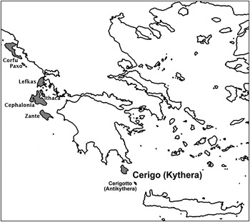
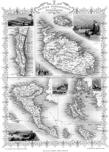
The island of Kythera – historical Cerigo – is geographically and strategically situated between the Peloponnese and Crete, between the Aegean and Ionian seas (Fig. 1). From 1809 to 1815, in the turbulence caused by war with France, British forces occupied several islands in the Ionian Sea including this small island. From 1815 to 1864, Cerigo, although geographically remote from the other islands, was part of the United States of the Ionian Islands, a self-governing protectorate of Britain. The seat of government was Corfu (Kerkyra), where a British Lord High Commissioner was in residence. Technically a sovereign state, the Ionians were often regarded in British accounts as a colony or possession of the expanding British Empire (Fig. 2). Thomas Gallant (Reference Gallant2002) has shown that the complex relationship between the ‘coloniser’ and the ‘colonised’ that existed in this environment was not static or uniform, but constantly under negotiation. In her examination of a similar situation on Cyprus, Kylie Seretis (Reference Seretis and Lawrence2003, 224) suggested that the colonial relationship embodies two concepts: the ‘mental template of the coloniser’ and the ‘reception and experience of the peoples being colonised’, and that these concepts were reflected physically in British-built structures in the Cypriot landscape.
Location of Cerigo (Kythera) in relation to the Peloponnese, Crete and the other Ionian Islands. Islands of the United States of the Ionian Islands are shaded and named.

‘British Possessions in the Mediterranean’ (Martin Reference Martin1851, 59). John Tallis and Company copper engraved map drawn by J. Rapkin and vignettes of harbours drawn and engraved by H. Winkles (from the author's collection).

On all the Ionian Islands, during the protectorate, there was a British presence, primarily military (Gallant Reference Gallant2002, 8) but partly civilian, including missionaries.Footnote 2 Each island's principal British representative carried the title of Resident or, in military terms, Sub-Inspector of the Militia. The Resident was, in effect, the primary authority on the island over local administrative councils. After 1832, there was an aspiration among the Ionians for unification with an independent Greece, culminating in a clash of interest between the locals and the British authorities (Gallant Reference Gallant2002, 9–14). In 1864, Cerigo and the other Ionian Islands were ceded to the independent Greek state. Kythera has many well-preserved structures dating to the first decades of the British protectorate, including a number of striking stone-built school buildings. Education in the schools was based on a British system embedded with evangelical religious principles that had gained popularity in England in the late eighteenth century and was known as the Lancastrian system after its founder, Joseph Lancaster.
The British period, 1809–64, comes at the end of a long history of external control of Cerigo from the thirteenth to the nineteenth centuries – predominantly Venetian, but briefly Ottoman, French and Russo-Turkish. Interactions with external powers have left imprints on the island physically, culturally and ideologically. Relying largely on primary British sources – official records, contemporary accounts and missionary reports – and local Kytheran archival material, this paper tells the story of British-built structures that have become part of the island's multi-layered historical landscape. The primary focus is the colonial educational movement on Cerigo: the relationship between the British (officials and missionaries) and the islanders in the establishment and running of the schools, that relationship's manifestation in the physical form of the British-built school buildings and subsequent changes detected in the function of the schools throughout the Colonial period. First, however, I set the Cerigo schools in context, highlighting some of the events and ideas that were in play in the early nineteenth century with a discussion of the Lancastrian school movement, the impact of the Protestant Mediterranean missions and the colonial initiative of public education in the Ionian Islands.
LANCASTRIAN SCHOOLS, THE BRITISH AND FOREIGN SCHOOL SOCIETY AND THE IONIAN ISLANDS
The Lancastrian educational system was distinguished by its use of fellow pupils as ‘monitors’ or subordinate teachers. It was designed to teach, at a low cost, large numbers of students at the elementary level. The instructional method was also known in English sources variously as the ‘monitorial’ system, the system of ‘mutual instruction’ (Gr. αλληλοδιδακτική) or – in foreign countries – simply the ‘British’ system. Joseph Lancaster, a Quaker from London, developed the monitorial system in the late eighteenth century (Lancaster Reference Lancaster1803), having made improvements to an earlier educational experiment introduced at an orphanage in Madras by Rev. Andrew Bell, a Church of England clergyman (Bell Reference Bell1797).
In 1801, Lancaster opened a ‘model school’ on Borough Road, Southwark, London based on his improved system. However, by 1808 he was in serious debt (Binns Reference Binns1908, 33). As a consequence, the ‘Society for Promoting the Lancastrian System for the Education of the Poor’ was set up as surety to continue his work. In 1814 the Lancastrian society was renamed the ‘British and Foreign School Society’ (hereafter BFSS), by which title it is still known today. With influential patronage, the number of schools employing the Lancastrian system spread rapidly within Britain as well as abroad (Binns Reference Binns1908, 88, 100). The Lancastrian movement vied with other schemes in Britain – particularly that established by Bell – and in Europe as an educational system for the masses (Barnard Reference Barnard1854, passim; Bowen Reference Bowen1981, 242–81). The rise and rapid spread of institutions of mass education at this time has been explained as a consequence of the social, economic and political factors that were forming the rationalised modern Western world of ‘citizen-based nation and state’ (Boli, Ramirez and Meyer Reference Boli, Ramirez and Meyer1985, 156; Ramirez and Boli Reference Ramirez, Boli and Mangan1994).
With foreign interest in the Ionian Islands in the late eighteenth and early nineteenth centuries, it is not surprising that revolutionary European educational ideas were introduced there, particularly by Ionians who had been trained abroad (Barnard Reference Barnard1854, 633; Leontsinis Reference Leontsinis1994). Written into the 1817 constitution of the United States of the Ionian Islands, Chapter 1 Article 23, was the provision for public education (TNA CO 136/7). The first British Lord High Commissioner, Sir Thomas Maitland (1815–23), was known to be opposed – or at best indifferent – to the need for educational reform (Dixon Reference Dixon1939, 225–8). Nonetheless, discussions on the adoption of a public school system along the lines of the mutual teaching method took place in 1819 in the Senate of the Ionian State (Aroni-Tsichi Reference Aroni-Tsichi2005, 35; Theotokis Reference Theotokis1956, 91). In addition, Maitland's attitude towards education was not universally held among the British. Liberal sympathies with the improvement of the Greeks, particularly in the wake of the independence movement, coloured many views on education. Frederick North, fifth Earl of Guilford, a noted philhellene appointed to organise public education in the Ionian Islands, was the one who recommended the Lancastrian system at the elementary level to the Ionian Senate (BFSS AR 1821, 117). Colonel George Whitmore, Maitland's chief architect and staunch supporter, claimed that Guilford's interest in public education for the masses arose after he had established the Ionian Academy on Corfu, when he was dismayed to find the first set of scholars extremely ignorant, thus making it necessary to found schools that taught the ‘first rudiments’ of knowledge (Johnson Reference Johnson1987, 62).
Accounts show that there were convergent Greek Ionian and British activities in educational reform, each group keen to publicise achievements from their particular viewpoint. Also, there were differences in British attitudes towards education of the masses that were complicated by prejudgements – whether idealised or debased – of the Ionian character. British missionary sources add a further dimension to this story. A visit by William Allen, a representative of the BFSS, to the Ionian Islands in September to November of 1819 was thought to be the catalyst in the establishment of Lancastrian schools in those British-held territories (Binns Reference Binns1908, 100).
William Allen, a Quaker and friend of Joseph Lancaster, travelled in 1818 from Britain to Russia, then in 1819 to Constantinople, the Greek mainland and the Ionian Islands (Binns Reference Binns1908, 100). On Zante (Zakynthos) and Corfu, Allen met with British officials and missionaries as well as local notables and priests. According to journal entries during his visit to Corfu, Allen indicated that he met with Thomas Maitland, who had responded positively to the adoption of the Lancastrian system for schools (Gilpin Reference Gilpin1847 i, 450–1). This statement is contrary to other accounts of Maitland's opinion of education and almost certainly reflects a degree of gullibility on Allen's part, as further meetings with Maitland proved difficult to arrange before his departure for Malta en route back to Britain.
On Zante and Corfu, Allen attended Bible Society meetings. Rev. Dr Pinkerton, the agent of the British and Foreign Bible Society, had formed the Ionian Bible Society on Corfu on 20 July 1819, and ten days later an auxiliary society on Cephalonia (Canton Reference Canton1904, 3–4; Clogg Reference Clogg, Batalden, Cann and Dean2004, 236; Dudley Reference Dudley1821, 25–6). This was immediately followed on 4 August 1819 by the establishment of the Zante Bible Society by Rev. Isaac Lowndes (SOAS Lowndes 1819). Two more Societies were organised, one each on Paxo and Ithaca, in the succeeding year (Canton Reference Canton1904, 4). The Societies were supplied with Bibles translated into Modern Greek by the British and Foreign Bible Society. These Bible Societies were often headed by local notables and counted both Greek and British individuals among their members. Gallant (Reference Gallant2002, 59) has suggested that high-ranking religious officials and members of the Ionian aristocracy often outwardly complied with British schemes – which I would argue included Bible Societies – as a way of creating their own western European identity.
According to missionary accounts, a vast number of religious tracts and Bibles in Modern Greek were distributed (St. Clair Reference St. Clair2008, 202–3). Yet missionaries, who saw this welcome reception of Bibles and tracts as a thirst for religious enlightenment, denied or ignored the fact that much of the population was illiterate (e.g. Wilson Reference Wilson1839, 213–4, 224; Episcopalian Watchman 1828, 249–50). Adolphus Slade, a British naval officer who served most of his military career in the Mediterranean, observed the ‘lavish distribution of Bibles’ during his travels in the Ottoman Empire in 1829–30 and noted that since paper was a rare commodity, books were often used as a source for waste paper. He also described Albanian klephts using the paper from Bibles to make wadding for their guns (Clogg Reference Clogg, Batalden, Cann and Dean2004, 237; Slade Reference Slade1854, 518–9; St. Clair Reference St. Clair2008, 203). In addition, among the literate, the 1810 Modern Greek edition of the Bible was declared ‘imperfect and inelegant’ because of the numerous ‘barbaric’ Turkish words it used (Clogg Reference Clogg, Batalden, Cann and Dean2004, 237–40). The pre-revolutionary movement to purify the Modern Greek language – as part of the creation of a national identity – was initially driven by the desire to emphasise the Classical pagan past (Gallant Reference Gallant2001, 10–11), but a number of reactionary schemes ensued, including Orthodox authorities' attempts to control the purified language (Mackridge Reference Mackridge2009, 133–42). Ilarion Sinaitis, censor and supervisor of the patriarchal press, began a more acceptable Modern Greek translation of the Bible in 1818 that was eventually published by the British and Foreign Bible Society in 1828 (Mackridge Reference Mackridge2009, 141 n. 75; Clogg Reference Clogg, Batalden, Cann and Dean2004, 244).Footnote 3
Two people Allen met during his visit to the Ionian Islands who had influence on public education in the early part of the British protectorate were Dr Athanasios Politis and Rev. Isaac Lowndes. Politis, a physician from Santa Maura (Lefkas), had trained as a doctor in Paris, where he had become familiar with the monitorial system (Gilpin Reference Gilpin1847 i, 448). British missionary sources indicate that he had carried out a ‘vigorous propaganda campaign’ (Binns Reference Binns1908, 106) to promote Lancastrian schools beginning in 1819. Subsequently, the first schools in this system were formed on Corfu and Santa Maura in 1820 (Theotokis Reference Theotokis1956, 91; Leontsinis Reference Leontsinis2000, 313). Politis' later career included his appointment as inspector-general of schools for the Ionian Islands (BFSS QE 1829, 85) and lecturer in chemistry at Guilford's Ionian Academy (Antjoulatou and Maniati Reference Antjoulatou and Maniati2000). When the young Rev. Lowndes met with Allen on Zante in 1819, shortly after the establishment of the Zante Bible Society, he had recently arrived from Malta as a representative of the London Missionary Society (hereafter LMS) (Missionary Register 1833, 236; Brown Reference Brown1854, 272–3). Lowndes became a zealous advocate of the educational movement espoused by Allen and a regular correspondent with the BFSS. In 1835 Lowndes was appointed inspector-general of the Ionian Island schools, a post he would hold until shortly before his departure for Malta in 1844.
During his sojourn in the Ionians, Allen also visited numerous schools and was appalled at the practice of teaching ‘maxims of heathen philosophers’ instead of Scriptures. It was his firm belief that Scriptures would lead to a better, more regulated, society:
The people here are dirty in their persons, they seem, however, industrious, and if they had but the blessings of education, including, of course, a knowledge of Scriptures, their improvement would doubtless be rapid and striking. (Gilpin Reference Gilpin1847 i, 449)
Upon his return to England, Allen continued to correspond with Lord Guilford and Sir Frederick Adam, who was later to become the second Lord High Commissioner (1823–32), as well as many of the people he had met on his visit to the Ionian Islands. Allen offered his impressions, made suggestions on organising the schools, and actively raised funds for the schools in the Ionian Islands.
The Lancastrian educational system set up in the Ionians was described under the heading ‘Commission for Public Instruction’ in the Colonial Office Blue Book of Statistics for 1829 (TNA CO 136/1393, 190) and this text was repeated in a truncated fashion in various editions of Robert Montgomery Martin's histories of the British colonies (Martin Reference Martin1835, 368; 1839, 595). A secondary school for language instruction (Ancient Greek and Latin, as well as English and Italian) and a Central school on the mutual instruction plan were established in the principal town of each island. The Central schools were responsible for training teachers in Lancastrian village schools who were under its immediate superintendence. The headmaster of the Central school was, in turn, under the direction of the inspector-general. Inspectors-general were expected to make regular visits to all schools on the islands. The secondary and Central schools' expenses were fully met by the government, but although there was government support for the poorest, many pupils' expenses in the village schools were defrayed by parents. The government also supplied furnishings, slates for writing, books and lodging for the teacher. This system was in place for two decades before the first official printed Colonial Office report on the schools appeared in Reference Martin1843 (Dixon Reference Dixon1939, 226; TNA CO 136/1256).
The BFSS supplemented the costs of running the schools by sending funds as well as lesson books and other school equipment, including lessons specifically destined for the Cerigo schools (BFSS AR 1828, 62). Missionary presses on Malta and later on Corfu also produced school texts (Wilson Reference Wilson1839, 208–12). Appeals on behalf of the BFSS for contributions to aid Greece (which included the Ionian Islands) appeared in periodical publications. The Gentleman's Magazine (1825, 24–5) printed a BFSS request for monetary assistance for improvements in Greece, insisting that education ‘must combine itself with the truths and with the sanctions of the Gospel’ as a prerequisite in attaining ‘moral feeling’. Similar appeals were printed in missionary magazines (e.g. Missionary Register 1830, 84–8). In 1831, it was reported that the BFSS contributed £1736 9s. 7d. – approximately 40% of its entire expenditure for the year – to the advancement of ‘scriptural knowledge in Greece’ (Christian Penny Magazine 1832, 41).
Training of teachers was also supported by the BFSS. There is some evidence that a small number of Greek boys were trained in Lancaster's original school in London (Gentleman's Magazine 1825, 25; Blaquiere Reference Blaquiere1825, 137; BFSS QE 1827b, 8; Bartle Reference Bartle1988). Boys were sent to London in the first few years of the Greek War of Independence; the first two were said to have come from Cyprus, purchased at a slave market in Smyrna by an English traveller in 1823 (Bartle Reference Bartle1988, 2). In 1824, Edward Blaquiere sent nine boys from Greece (Bartle Reference Bartle1988, 11). St. Clair (Reference St. Clair2008, 144) speculated that these boys who were brought to England by Blaquiere were used primarily for propaganda to engage the British public's interest in the Greek Committee in London, founded the year before by Blaquiere and John Bowring to raise money for the cause of the Greek War of Independence. Indeed, boys sent by Blaquiere remained only one or two years in London and most were too young to be trained as teachers (Bartle Reference Bartle1988, 4). Based on references in BFSS annual reports, a few other Greek boys can also be documented, some returning to their homelands as teachers (Bartle Reference Bartle1988, 3).
Nicholas Cacuratto was sent to the Southwark school in 1824 and was said to have returned to his native Cephalonia a year later to become a private teacher (Bartle Reference Bartle1988, 2). Among Greek boys sent to the United States between 1823 and 1828 was 11-year-old Anastasius Karavelles, a native of Zante and son of a Greek priest (Anderson Reference Anderson1872, 177; Saloutos Reference Saloutos1955, 156; Missionary Herald 1823, 113). Other than these two references to boys from the Ionian Islands, there is no direct evidence for the training of teachers in Britain or the United States for the Ionian schools. By 1829, the teacher training manual, the BFSS Manual of the System of Primary Instruction, was translated into Modern Greek and printed by the American missionary press in Malta, with proposed alterations by Dr Politis, for use in the Ionian Islands (BFSS QE 1829, 85).
Foreign missionaries, particularly foreign women, were concerned with the teaching of females and many of the schools for girls were said to have come almost exclusively under their control (Goodman and Leach Reference Goodman, Leach and Morgan2002, 54). Close supervision was considered necessary for girls to assume such characteristics as honesty, quietness, gentleness and cleanliness – contemporary British cultural notions of female virtue suitable for taking up duties in the household (Goodman Reference Goodman1999, 70). Information on female education in the Ionian Islands comes from the reports of two organisations: the BFSS Ladies Committee (Bartle Reference Bartle1995) and the Edinburgh Ladies Society for the Education of Greek Girls.Footnote 4 Joyce Goodman (Reference Goodman2000, 10–11) has noted that the language used in these reports shows that British women educators represented themselves as professional, authoritative and morally superior, particularly in relation to colonial subjects.
The first British woman involved in female education in the Ionian Islands, initially on Cephalonia and then Ithaca, was Mrs Kennedy, the wife of the evangelical medical officer famous for his memoir of Lord Byron (Kennedy Reference Kennedy1833). The Rev. Samuel Sheridan Wilson indicated that, with the patronage of the wife of a local notable, Mrs Kennedy had succeeded in forming the first female school on the Lancastrian plan in Greece with 33 girls learning reading, writing, arithmetic, sewing and embroidery (SOAS Wilson 1824). In addition, Rev. Lowndes' wife, mentioned periodically in BFSS reports, was involved in female education on Corfu. Mrs Dickson, sponsored by the Edinburgh Ladies Society, trained at the BFSS Central school in London to learn the monitorial method of teaching (BFSS QE 1829, 85) and on 24 August 1827 set sail with her missionary husband from London to Cephalonia (Missionary Register 1827, 503; BFSS QE 1827a, 7–8). The Edinburgh Ladies Society also financed Miss Robertson, Miss Goodard and Miss Anderson to teach girls in the Ionian Islands (Goodman Reference Goodman1999, 62; Reference Goodman2000, 10; Gallant Reference Gallant2002, 178; Wilson Reference Wilson1839, 215–21).
The primary objectives of the monitorial system were to encourage pupils to acquire habits of industry and order, be taught reading, writing and arithmetic and ‘direct their minds to the Blessed Gospel’ (BFSS 1839, 5). Pupils were taught the ‘common rudiments of learning’ (BFSS 1839, 6) before they applied themselves to the employments by which they were to earn their livelihoods. Although the curriculum was in the native language, there was interest in promoting the teaching of English (BFSS AR 1829, 85). In the Colonial Office records of statistics are lists by year entitled Return of all British Subjects on the Establishment of the United States of the Ionian Islands, which list ‘English Professors’ among the personnel employed by the Ionian government, some appointed as early as 1818 (TNA CO 136/1391). Rev. Lowndes, in a letter dated 5 February 1820 from Zante, indicated that there was a move by the Ionian government to establish ‘English schools’ on the islands to establish the English language (SOAS Lowndes 1820). He is, no doubt, referring to the secondary schools established on each of the islands. Lowndes later authored two school grammar books, Greek to English (Lowndes Reference Lowndes1827) and English to Greek (Lowndes Reference Lowndes1837). His colleague, the Rev. S.S. Wilson, in charge of the mission press in Malta, noticed a need for educational publications and published books specifically for use in schools in the Ionian Islands, including an Anglo-Greek Primer (Wilson Reference Wilson1829; Reference Wilson1839, 208–10).
By the 1820s, a primary school system for the education of the masses had been set up in the Ionian Islands with input from foreign missionaries. Teachers, books and funds for these schools were being channelled through the BFSS, the LMS and other similar organisations. Missionaries had their own agenda, generally in sympathy with philhellenic ideals, but concerned with the improvement of the Greeks through the teachings of the Bible. They attempted to achieve this through school lessons and Bible Society meetings. Ionian Islanders were initially receptive to these initiatives as a method of nation building and establishing a western European identity (Gallant Reference Gallant2002, 57–61).
THE BRITISH SCHOOLS ON CERIGO
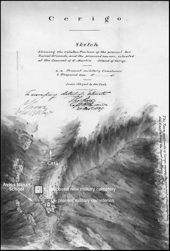
Perhaps because Cerigo is distant from the other Ionian Islands, there is no direct evidence for the establishment of a Bible Society, or of a permanent missionary station. There was, however, a British presence on the island in the form of a small military garrison and a British Resident (Martin Reference Martin1839, 597; TNA CO 136/1366/690–2). Tombstones, now in the Archaeological Museum of Kythera, provide a physical reminder of this British presence. Engraved on the tombstones are names of British soldiers as well as infant children and wives of military personnel with dates of death on those that are legible ranging from 1811 to 1860. These tombstones were rescued from the old British burial grounds near the ruined Convent of San Martino or Ayios Minas as it appears in Greek (TNA MPH 1/886/7–10). In addition to the families of the military personnel, there may have been a few other British civilians living on the island, although documentary evidence is scarce. In the Local Archive of Kythera, the 1833 census for the island (TAK Απογραφή 1833 i, 13) lists a ‘Whielmo’ (William) Culson, age 42, a Protestant from Inghiltera (England) as a resident in the Città of Hora, employed as a Maestro (teacher). This same William Coulson appears in the Colonial Office records as an ‘English Professor’, appointed by the Ionian government in 1818 and appearing as a teacher in the public schools on Cerigo in 1829 (TNA CO 136/1366/690; CO 136/1391). Periodically, there were also foreign visitors to the island.
Tertius T. C. Kendrick (Reference Kendrick1822, viii) visited the island briefly in 1813, one of the few foreign visitors to the island during the earliest years of British rule. He thoroughly disliked the island and its people, stereotyping Ionian Islanders as ‘Hottentots’ and regarding them as simpletons. He also remarked that the British soldiers stationed on Cerigo considered it ‘a place of honourable exilement’ as civilisation had ‘entirely fled from the inhabitants’ (Kendrick Reference Kendrick1822, 90). Gallant (Reference Gallant2002, 17) has argued that this form of stereotyping, common in some British accounts, was a way to create a subordinate identity for the Ionians, thus separating them from the Greeks of the Golden Age of the past and justifying British imperial rule. Most accounts of the island after Kendrick, in the 1820s and 1830s, come from individuals who travelled there in an official capacity. Despite its marginal location and the lack of civilisation reported by Kendrick, Cerigo – for a short time – became known as far away as Britain and the United States for its exemplary Lancastrian schools.
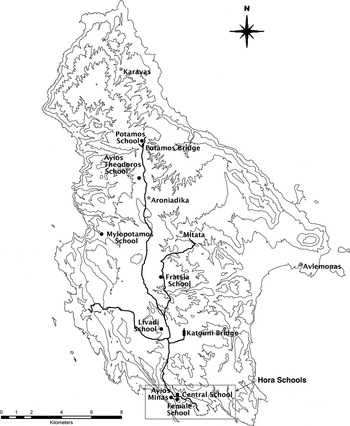
It was due, in part, to the zeal of one particular British Resident on Cerigo, Captain John MacPhail (1823–31),Footnote 5 that a number of Lancastrian schools were established on the island. The Lancastrian schools were by no means the only schools on the island, as different systems (both public and private) co-existed, including the Bitzamenion Greek School, a non-Lancastrian public school formed in the early 1820s and named after an Orthodox priest whose bequest enabled its establishment (Leontsinis Reference Leontsinis2000, 317). Captain George Matthew Jones (Reference Jones1827 ii, 533) recorded in his travel memoirs that Cerigo Lancastrian schools in the towns of Hora and Potamos were in operation in 1823 and that other districts had petitioned for the establishment of schools. In order to reinforce this British system, purpose-built structures were erected between 1825 and 1826 and situated in Hora, Livadi, Ayios Theodoros, Fratsia, Mylopotamos and Potamos (Fig. 3).
Map of Kythera showing the placement of the first British schools (•), major roads, key bridges and settlements where later schools are established (*). Roads and bridges are based on a map of Cerigo ?1853–8 (TNA MFQ 1/673/7).

The chief published source for the early operation of these schools is Mrs Eleni Harou's series of articles in a local Kytheran monthly newspaper (Harou-Koronaiou Reference Harou-Koronaiou1989a; Reference Harou-Koronaiou1989b; Reference Harou-Koronaiou1989c; Reference Harou-Koronaiou1990a; Reference Harou-Koronaiou1990b; Reference Harou-Koronaiou1990c; Reference Harou-Koronaiou1990d). Harou made use of many unpublished documents in the TAK, particularly the extant school registers. Information on the Cerigo schools presented here comes from these articles and unpublished archival sources in the TAK, most dating from 1824 to 1828 and comprising school registers, financial records, absence accounts, and miscellaneous papers. These data are supplemented by information contained in British-period censuses in the TAK, the earliest four dating to 1814, 1822, 1825 and 1833, all organised slightly differently and containing data in various degrees of detail. LMS archives contain diaries, letters and reports on the printing press in Malta. BFSS quarterly extracts and annual reports discuss the provision of teachers and funding to Greece and the Ionians as well as printing extensive quotes from correspondents' letters. Colonial Office records contain official reports, statistics and letter books from the Resident on Cerigo. Finally, there are published first-hand accounts from the foreign visitors to the island. Drawing on these sources to illustrate the interplay between British authorities, locals, and foreign missionaries, I first discuss teachers, schoolbooks, the number of schools and students, and data regarding the construction of the school buildings on Cerigo. Secondly, I explore the possible significance of the architecture and placement of the school buildings in the landscape. Lastly, I consider some of the factors for change in the Cerigo schools after their establishment.
ESSENTIAL ELEMENTS: TEACHERS, BOOKS, PUPILS AND BUILDINGS
Teachers
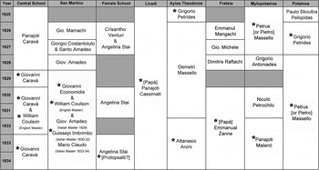
Harou (Reference Harou-Koronaiou1989b) indicated that the teachers on Cerigo were either ‘foreigners’ (i.e. non-Kytheran) or were locals who had graduated from the Central school at Hora. The most direct evidence comes from a few names listed in the school registers and the education reports in the financial returns for the island (Fig. 4). Supplementary information comes from the 1833 census of the island that lists the profession of Maestro against these names although two of the teachers are listed as Sacerdoti (Orthodox priests) and are annotated [Papà] in Fig. 4. A few foreign (i.e. non-Greek) teachers are listed in this census: one English, and two Italian. All three are listed as resident in the Città of Hora. Although it is possible that members of the Cerigo elite, who tended to reside in the Città, may have brought private tutors to the island, two of these foreign teachers – William Coulson (English) and Guissepi Imbrimbo (Italian) – appear as public school language teachers in the education reports. Giovanni Economidis, the schoolmaster at the secondary school – Ayios Minas or San Martino as it appears in Italian – is said to be from Scio (Chios) (TNA CO 136/1256, 28) and annotated as Naturalizato (naturalised) in the 1833 census (TAK Απογραφή 1833 i, 12). In both the 1833 census (TAK Απογραφή 1833 i, 24) and the 1843 official report on the schools (TNA CO 136/1256, 52), the Patria (homeland) listing for the headmaster at the Central school, Giovanni Caravà, is the Ionian Island of Ithaca. Gregorio Petrides, who is listed in the official 1843 school report as originally from Macedonia (TNA CO 136/1256, 159) is, however, listed as a native of Cerigo in the 1833 census (TAK Απογραφή 1833 i, 16).
Names of teachers 1825–34. From school registers (TAK Uncatalogued 1825–8) and Colonial Office education returns (TNA CO 136/1366/690). Names preceded by an asterisk appear in the 1833 census (TAK Απογραφή 1833). Hatched areas indicate no listings.

The other teachers are almost certainly natives of Cerigo. The surnames Aroni, Casamatis, Malano, Petrochilo, Protopsalti, Raftachi, Stai and Zanne are local Kytheran names that appear throughout the eighteenth-century censuses of the island (Maltezou Reference Maltezou1997 iii, passim; Kalligeros Reference Kalligeros2002, passim). Marselos, a Venetian surname, is attested on the island as early as the sixteenth century and is a variant of the more common Kytheran name of Masselos (Kalligeros Reference Kalligeros2002, 461–6). It is clear from this evidence that most teachers in the public schools on Cerigo were Greek, and in many cases were native to the island. This is a slightly different picture than that painted by missionary sources, which highlighted the function of foreign missionaries, particularly women, as teachers.
Books
Indirect evidence for textbooks used in the schools on Cerigo comes from journal entries of Rev. John Hartley dated December 1825 (Missionary Register 1826, 327). Hartley, a representative of the Church Missionary Society, was en route from Zante to Smyrna when his vessel was forced into harbour at Cerigo for a few days due to bad weather. An officer of the 90th regiment stationed on Cerigo (described as a ‘Christian friend’) informed Hartley that there were no fewer than 900 souls on the island who were instructed in the Lancastrian system and who used the New Testament as a schoolbook. Lancaster and the BFSS recommended the New Testament as a textbook for the ‘best readers’ in the schools (Lancaster Reference Lancaster1810, table; BFSS 1816, 15). In addition to the availability of Bibles, the translation of Allen's School Scripture Reading Lessons into Modern Greek was set in motion during his 1819 visit and it was eventually printed in Corfu in 1824 (Gilpin Reference Gilpin1847 ii, 148). Hartley's evidence, however, is highly suspect as the information is second- or even third-hand, told by people who wished to see the New Testament used in this manner.
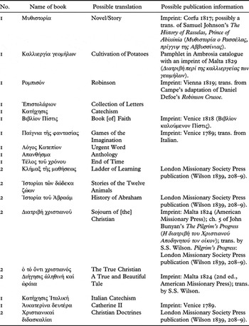
On the other hand, direct evidence for schoolbooks comes from an uncatalogued document dating from 1826 in the TAK. Table 1 shows the data from this one-page document, listing book titles and the number of copies in the Mylopotamos school. Many of the titles suggest religious themes and a number are probably written in an abridged form. For example, Collection of Letters may refer to the Epistles of Saint Paul. Μυθιστορία may refer to a specific and well-known story immediately recognised by contemporary readers of the list, such as The History of Rasselas, Prince of Abissinia by Samuel Johnson, originally published in 1759 and known to have been translated into Modern Greek and printed in Corfu in 1817. Italian Catechism is most likely the same as Catechism, but in Italian, rather than a Roman Catholic catechism. The Italian language for historical reasons was commonly spoken in the Ionian Islands and was also the language of the British Administration in this early period. A few book titles on this list also match titles printed by missionary presses on Malta. For example, adapted from English elementary texts, Ladder of Learning, printed by the LMS press, was a school primer designed as syllabus-based lessons, said to be a new form of teaching in Greece (Wilson Reference Wilson1839, 208–10). It included numerous religious and moral works such as the Nicene Creed, Isaac Watts' First Catechism, and the sentimental children's poem ‘My Mother’ by Ann Taylor.
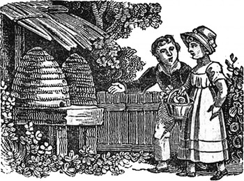
Woodcut illustration from Rev. S.S. Wilson's Νεαρά Λύρα (Wilson Reference Wilson1830, 45).

Transcription of the 1826 list of books in the Mylopotamos school (TAK Uncatalogued 1826) signed by the teacher, Petros Marsellos, with possible translations of the titles and other information about the publication and origin of the books from the LMS Press (Wilson Reference Wilson1839, 208–9) or imprint data from the Ambrosia catalogue <http://ambrosia.ascsa.edu.gr:8991/F/> of the Gennadeion Library (Athens).

The title Robinson on the 1826 list probably refers to tales copied from Daniel Defoe's Robinson Crusoe. In the late eighteenth and early nineteenth century there were no fewer than 700 editions, translations and imitations of Robinson Crusoe (Watt Reference Watt1951, 95–6). Elements from the book were adapted employing local traditions in numerous European countries, thus producing many regional ‘Robinsons’ (Kanatsouli Reference Kanatsouli1997, 129). One such variation, Robinson der Jüngere by Joachim Heinrich Campe (Reference Campe1781), was translated into Greek before the Greek War of Independence (Kanatsouli Reference Kanatsouli1997, 129–32). The title Sojourn of [the] Christian is probably also a derivative book, a section taken from John Bunyan's Christian allegorical story, The Pilgrim's Progress, translated by Rev. S.S. Wilson and printed on Malta by the American Missionary Press.
The inclusion of the title Cultivation of Potatoes is interesting since the introduction of the potato to Cerigo and the other Ionian Islands was, at this time, a relatively recent phenomenon. Robert Jameson, a medical officer and natural historian, published his observations on Cerigo:
Some of our kitchen garden plants have been introduced with success. Potatoes are gaining ground; the Cerigotts gradually acquiring a taste for them … (Jameson Reference Jameson1836, 279.)
Popular accounts indicate that the French introduced potatoes and tomatoes to Corfu and, after a period of initial resistance, the crops gained general acceptance due to the efforts of the Ionian-born first Kyvernitis of independent Greece, Ioannis Kapodistrias. Though the literal translation of the French pomme de terre into Greek (γεώμηλον) gives credence to these claims, these popular accounts are unverifiable. It is more likely that potatoes, tomatoes, and other kitchen garden crops were introduced in a piecemeal fashion by numerous authorities to various parts of the Ionian Islands during the late eighteenth and early nineteenth centuries. Nevertheless, the inclusion of this instructional book would have provided practical information on a relatively new crop.
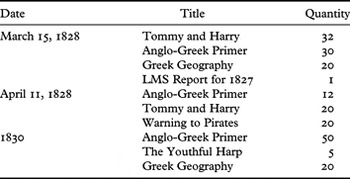
Further evidence dating from 1828 to 1830 comes from accounts of the LMS printing press (SOAS Wilson 1828–30). Table 2 lists books for instruction that were sent to Captain MacPhail on Cerigo by Rev. S.S. Wilson, no doubt in Modern Greek translation, although the titles were listed in English. The Anglo-Greek Primer,Footnote 6 written by Wilson and discussed above, and Greek Geography were designed as syllabus-based teaching texts. More interesting is Tommy and Harry, a story about two brothers, one good, one bad, ending with an appropriate moral providing peace and prosperity to the good brother and ‘just judgement’ to the bad one (Kendrew Reference Kendrew1820, 30). This was a chapbook, one of many small-format, short, cheaply produced, derivative stories often with crude woodcut illustrations published in the eighteenth and nineteenth centuries aimed at a youthful readership (Grenby Reference Grenby2007, 289–90). These moralising tales, translated into numerous languages, were appropriate fodder for missionary distribution. Rev. Wilson (Reference Wilson1839, 212) also authored and printed sacred and moralising stories for children, including The Youthful Harp, translated and printed in Malta as Νεαρά Λύρα (Wilson Reference Wilson1830). Although these types of tales were translated into Modern Greek, there was no attempt to adapt them or their woodcut illustrations (Fig. 5) to the receiving culture (St. Clair Reference St. Clair2008, 202).
Books sent to Captain MacPhail from Rev. S.S. Wilson from 1828 to 1830 (SOAS Wilson 1828–30).

The title Warning to Pirates is not among the list of books that Wilson (Reference Wilson1839, 208–9) lists as printed by the LMS on Malta. However, piracy was endemic in the eastern Mediterranean at this time, causing considerable problems for the British consular service (Gunning Reference Gunning2009, 94; Jones Reference Jones1934). The ‘Cerigo channel’ was considered ‘infested by lawless Maniote cruisers and Grabusa pirates’ (Jones Reference Jones1934, xxvii) and numerous instances of reports of piracy appear in the Colonial Office Resident's papers (TNA CO 136/1332, CO 136/1333). This book may follow the pattern of the moral tales, perhaps modelled on Walter Scott's The Pirate published in 1822, in an attempt to alleviate a troublesome situation. After 1830, there are no indications that Wilson sent more books to Cerigo. By 1832, Captain MacPhail, now stationed on Santa Maura (Yeardley and Yeardley Reference Yeardley and Yeardley1835, 25–8), was sent books for use in schools there (SOAS Wilson 1828–30). Statistics cease in 1835 with the closure of the LMS press on Malta (Lovett Reference Lovett1899, 639). It is clear from this evidence that a British missionary agenda was being enforced through the types of books sent to the Cerigo schools.
Schools and Pupils
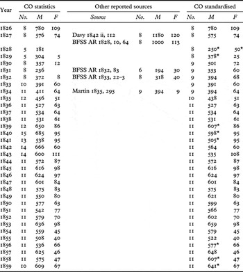
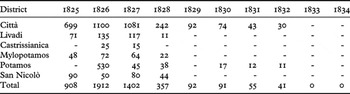
Sources vary in their listing of the number of schools established on Cerigo and the number of students – both male and female (Table 3). Differences in terminology make it difficult to standardise and interpret statistics. Sometimes, but not always, the term ‘public school’ refers exclusively to Lancastrian schools – schools run on the monitorial system of instruction. Female schools were sometimes described as Lancastrian since they also practised the same monitorial system of education. At other times, female schools were listed as private or not mentioned at all. Discrepancies may reflect different conceptions of data categorisation or inaccurate methods of data collection.
Number of schools and pupils (male and female) on Cerigo from official and unofficial sources. Colonial Office statistics are derived from totals listed in education reports in the financial returns 1826 to 1859 (TNA CO 136/1366/690–2). Colonial Office standardised figures are re-formulated statistics made consistent and comparable.

* Estimated figure
Data from an official report of 1825 in the Corfu Archives list five ‘Excellent’ Lancastrian schools on Cerigo with 443 students (Theotokis Reference Theotokis1956, 103). However, official Colonial Office Financial Returns for each island, standardised in form, begin in 1826 and include reports on education (TNA CO 136/1333, Circular 79 dated November 21st, 1826). Later, summary figures compiled from these Financial Returns appeared for all the islands in the annual Blue Book recording system adopted in 1828 (Martin Reference Martin1839 i, preface). Colonial Office Financial Returns present detailed information on location (district, parish, toponym), mode of instruction, teachers, salaries, and count of pupils by gender, as well as a section for miscellaneous notations for each, allowing for a greater understanding of how the numbers were calculated and conceptualised. It should also be taken into account that the official education reports only show those schools – public and private – that received financial support from the central government.
Ayios Minas/San Martino is often referred to as a free school or a secondary school, but occasionally as a school of mutual instruction or Lancastrian school. In several instances, it is listed twice: usually once as a public school and once as a private school. In these cases, the private Ayios Minas/San Martino usually lists the Latin master only and may reflect an option within the same physical space of the school for private Latin study. In 1833, however, San Martino is listed as both a public free school and a public secondary school. Since students are often counted by language instructor under Ayios Minas/San Martino – governed by the fact that these are primarily financial returns listing the instructor's salary – it is also possible that the total student count for this school is inflated with cross-listings of pupils who were instructed in more than one language.
On occasion, schools are also left off the record: in 1828 and 1829 neither the Mylopotamos nor Fratsia schools are listed, although there are school registers in the TAK indicating that the schools were attended in these years (TAK Uncatalogued 1825–8). Total counts of schools and pupils in many of the reports (1834–5 and 1839–43) are tallies of all schools regardless of their designation as public or private. Tabulations of figures are in some cases incorrect and the inaccuracies, along with transcription errors, are repeated in the Blue Book statistics. Differences also occur between these official reports and second-hand accounts, which often reflect particular agendas.
John Davy (Reference Davy1842 ii, 112), Inspector-General of Army Hospitals, visited Cerigo in 1827, where he was informed that 10% of the total population were in school. Although Davy's number of schools (eight) may be plausible, his figures for pupils (1180 male, 120 female) are most likely inflated, possibly because he had included non-Lancastrian pupils in his count. His (or his informant's) motive seems to have been to illustrate the benefits of education brought by the British to a receptive population, and thus to praise Captain MacPhail's efforts on Cerigo as a successful example. Notably, MacPhail reported in a letter to the BFSS in 1827 (BFSS AR 1828, 10) that there were seven male schools with 1000 pupils, and information sent by an anonymous correspondent (BFSS AR 1828, 64) listed 113 female pupils. These figures closely approximate Davy's elevated numbers and, as we saw above, the 900 reported by Rev. Hartley for 1825.
The BFSS 1829 Report quotes a letter received from the Rev. Lowndes that draws on a report by the school inspector-general, Dr Politis, indicating that a number of schools had been established on Cerigo (BFSS AR 1829, 29). A more comprehensive report from Captain MacPhail appears in the BFSS Report of 1831 on the establishment of schools and their welcome reception by the local population of Cerigo (BFSS AR 1831, 15–16). However, the only BFSS accounts of itemised and tabulated numbers of schools and pupils by island, said to be extracts from official reports, date from 1832 and 1833, referring to conditions in the previous years (BFSS AR 1832, 83; BFSS QE 1832, 71–2; BFSS AR 1833, 22–3). BFSS reports after this time do not list the number of Lancastrian schools by island, but simply give a total for all the Ionian Islands, although special mention is still made of the female schools.
In the official Colonial Office statistics, females are also to be found, in small numbers, in the Central school as well as in schools in outlying areas. In the years that the girls' school is not listed (1829, 1830 and 1832), a small number of female pupils is recorded, which represents female pupils within the predominantly male Lancastrian public schools. Martin (Reference Martin1835, 292) follows this same pattern when he lists only nine female students for 1834. It is also notable that the number of female students in missionary records for the years 1831 and 1832 appears to reflect the significance placed on the education of girls by missionaries. The official record during those two years, on the other hand, chose not to record statistics from the female school in the total count of public school pupils.
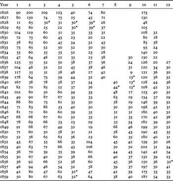
Taking these inconsistencies into consideration, Table 3's standardised Colonial Office statistics show a more realistic picture of the number of government-subsidised public schools and pupils, while Table 4 breaks these figures down by individual school. Ayios Minas/San Martino is listed only once with a total of all pupils, not separated by language instructor. The female school is listed once and all pupils are counted. For the years that schools are missing from the accounts (e.g. 1828–9 and 1839–41), the school is counted, and the number of pupils is estimated based on an average of the number of pupils appearing before and after that particular year. At first glance, it appears that there is a steady increase in the number of schools until Reference Martin1836, when the number levels at 11 public schools. Regardless of minor fluctuations, there also appears to be a gradual increase in the number of pupils after 1827, giving the impression of growth. However, examining these numbers in isolation is misleading. I will come back to these statistics in discussion regarding subsequent changes in the operation of the schools.
Number of pupils by school in Cerigo 1826–59 (TNA CO 136/1366/690–2). 1. Ayios Minas/San Martino, 2. Hora Central, 3. Hora female, 4. Livadi, 5. Fratsia, 6. Mylopotamos, 7. Ayios Theodoros, 8. Aroniadika, 9. Mitata, 10. Potamos, 11. Caravà (Karavas), 12. Cerigotto.

* Estimated figure
Buildings
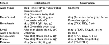
The initial Lancastrian school buildings on Cerigo were constructed within a short period of time, under the residency of Captain MacPhail (Table 5). Two account books for the building of schools located in the TAK support this statement. The first account book dates from November 1824 to August 1825 for the schools at Mylopotamos, Fratsia, Livadi, and the female school in Hora (TAK EK4).Footnote 7 The other book dates from slightly later (October 1825 to July 1826) and relates to the school at Potamos (TAK EK6).Footnote 8 These accounts itemise salaries for a number of individuals and payment for school furniture, but do not include land, building materials, or a comprehensive list of all the labourers. A few local men are listed in the capacity of M. Marangone and Soprastante. The title of Maestro Marangone, a Venetian Italian term, translates as ‘master carpenter’ and Soprastante as ‘superintendent’ or perhaps ‘foreman’ of work gangs. Since the rate of pay per day for the M. Marangone is substantially higher than the rate of pay for the Soprastante, it is likely that the ‘master carpenter’ had a more elevated role and was possibly the designer or building engineer. The repetition of names in the register in relation to several buildings suggests strongly that the construction of the schools was part of a unified building programme, probably overseen by a small group of people.
Establishment and construction of Cerigo Lancastrian schools under the residency of Captain MacPhail.

There was also a peak in construction activity at this time in public works. Captain Jones (Reference Jones1827 ii, 524–36) spent a month on Cerigo in 1823 when he made note of the numerous improvements effected by MacPhail, including the construction of bridges, roads and wells. John Davy, again in the account of his 1827 visit to the island, remarked:
Whilst Major Macphail was resident of Cerigo, he exerted himself strenuously to improve the island. He has assured me that the rudeness of the people and their ignorance were almost beyond belief; and that in carrying on ordinary works connected with road-making, the natives could contribute little more than bodily labour; if a rock was to be blasted, or an arch turned, he had to direct it, and a cyclopaedia was the source of his information. The mason who under his directions, constructed the first bridge that was ever seen in Cerigo, had not the least confidence in the strength of the arch, being ignorant of the principle, unacquainted even with the form: shortly after it was completed a violent storm occurred by night; the following morning early the mason was found on his knees, looking despondently at the bridge, and praying to the Virgin to defend it, and save it from destruction from the torrent. (Davy Reference Davy1842 ii, 40)
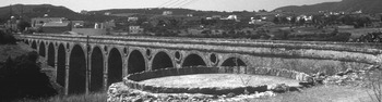
Various records on expenses for the construction of roads and other public works exist in the Colonial Office archive, confirming Jones' and Davy's observations (TNA CO 136/1366/690–2).Footnote 9 The Katouni Bridge (Fig. 6) is possibly the bridge mentioned by Davy, constructed in 1826 (TNA CO 136/1366/690). Tested in the 1990s for its engineering soundness, the bridge's ability to withstand seismic activity was attributed to the relieving holes constructed between the parabolic arches of the bridge, a technique devised by an English mason in 1754 (Leftheris et al. Reference Leftheris, Stavroulaki, Sapounaki, Tsofopoulou-Gkini, Brebbia and Jager1999, 307). The bridge at Potamos, an architecturally similar, but smaller, version of that at Katouni, was constructed around the same time.
Katouni bridge from the southeast (photograph by John Bennet 2002).

In a report to the BFSS, MacPhail explicitly states that funds to build the schools were raised voluntarily and there was very little governmental intervention (BFSS AR 1833, 15). Jones supports MacPhail's statement, saying that:
… the Cerigotes are so convinced of the benefit derived from it to themselves and the island generally, that they now work or pay willingly, exultingly exclaiming, ‘this does not go to Corfu, this remains with the island’. (Jones Reference Jones1827 ii, 533)
Leontsinis (Reference Leontsinis2000, 349), in his social history of the island, states that the ‘Mylopotamos and Livadi schools were built entirely by voluntary contributions from the inhabitants concerned’, indicating that individuals were ‘inspired by patriotism’ and that they were ‘sensible of the benefits accruing from their children's education’. The dedicatory plaque on the Livadi schoolFootnote 10 cites a local philanthropist, Ioulios Kasimatis, who donated the land. Both dedicatory plaques on the MylopotamosFootnote 11 and Livadi schools also stress the patriotism of the local inhabitants. In addition, the absence of common labourers in the TAK account book for the construction of the Mylopotamos school bears out Leontsinis' statement. The only individuals named who received payments, listed under the Mylopotamos school, were superintendent, ‘master carpenter’, and at the very end of the list one stonemason (Muratore) as well as those who supplied interior fittings (TAK EK4, ff. 1–2). However, accounts for the Livadi school in the same book are not as clear, listing payments to multiple superintendents as well as a number of stonemasons and other workers (TAK EK4, ff. 12–17).
MacPhail's ‘governmental intervention’ may have been a reference to the angaria system – often called ‘forced labour’ – that enabled authorities to improve the physical infrastructure of the island. Forced labour was considered iniquitous by the local population and remembered with aversion long after it had been abandoned in 1829 and replaced by a local indirect tax system to pay for labour employed on public works (Leontsinis Reference Leontsinis2000, 347–53). Evidence for the use of forced labour comes from the Colonial Office Angaria Book 1824–8 for Cerigo (TNA CO 136/1364) and the account book for the construction of the school at Potamos (TAK EK6). The Colonial Office Angaria Book simply lists names and accounts for however many days a job took and the number of mules available by month without recording the actual job. The Potamos account book, however, is specifically for the building of the school and contains lists (Lista Indicante gli incassi fatti nell angaria della Scuola Potamò) of individual labourers and the equivalent payment in pounds, shillings and pence that was extracted as angaria. It is likely that the Potamos school angaria list was kept because the labourers who worked on the school were exempt from road and bridge building in the area, as mentioned in the Quarterly Report on the Construction of Roads 1 May to 31 July 1826 (TNA CO 136/1366/690).
An undated document in the TAK describes annual contributions imposed by the local administration of the island (the Reggenza) for the benefit of the school and teachers (TAK Uncatalogued n.d.). The first section deals with enforced contribution from some Cerigo churches, paired with a contribution for candles or wax that had formerly been paid to the Venetian government. It is puzzling that the singular use of the word school is used in the heading, perhaps indicating an early date for the document prior to the establishment of numerous public schools on the island. This new contribution – partly to pay for schools and partly to cover candles in cases where it had formerly been levied – seems to be a continuation of a Venetian practice, the money simply re-routed, in part, for a new purpose. The second section deals with contributions imposed on shops to support teachers. It lists shopkeepers' names: four in the Borgo (town) of Hora, five in Avlemonas, and twelve in Potamos. The contribution is calculated in relation to existing monies levied on quantity of goods sold. This second list provides a clue to the date of the document.
San Nicolò (Avlemonas) is first mentioned as a parish church in the 1822 census, thus implying a settlement, though the church existed prior to that period. The 1822 census is organised by settlement rather than parish and lists only heads of households, giving no specific ages but the numbers of individuals in the household by gender and age category. Only one name in the 1822 census, Anagnosti Todorachachi (sic), matches the list of shopkeepers, Il figlio di Nicolin Todoracachi detto Anagnosti (son of Nicolas Todoracachi called Anagnosti). The same man is listed (age 42) in the 1825 census (TAK Απογραφή 1825, 105 recto) and again in the 1833 census (age 48) with ‘merchant’ as his profession (TAK Απογραφή 1833 ii, no. 1876). None of the other names under Avlemonas appear in any of the censuses in the parish of San Nicolò, which may indicate they lived elsewhere. Some merchants' names listed in Hora and Potamos appear in these same three censuses in the parishes of those towns, although in 1825 several of the merchants are quite elderly and at least two are deceased, as their widows are listed (TAK Απογραφή 1825, 8 verso; 178 recto). It is likely, therefore, that this document listing annual contributions for the schools and for teachers was drawn up at a time when the first British schools were established, i.e. after 1822, but before 1825.
Another document in the TAK, the Book of Income and Expenses for the schools (TAK EK5), dating from 1824 to 1828, provides further evidence relating to the provisions for the running of the schools. Many of the entries in the Revenue column (Entrate) list income from individuals, church officials (simply listed as Monsigniore) and other officials such as the Resident (Reggente). The entries in the Expenses column (Spese) consist of payments for supplies: paper and different types of printed forms, books, a variety of pens, wall clocks and the like. In 1827 rent payments for the female school begin (TNA CO 136/1366/690). By the end of 1828, there was a small surplus. The back of the book contains accounts of interest on the cumulative surplus. Overall, the Cerigo schools appear in the late 1820s to have been in sound financial condition: new buildings and furnishings, a steady supply of books, paper and pens, and a system set up to ensure their maintenance.
THE SCHOOLS AND THE IMPERIAL LANDSCAPE OF CERIGO
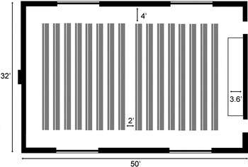
In 1809, Joseph Lancaster outlined the physical layout of an ideal school and later the BFSS, in the various editions of their instructional manuals (1816–43), made improvements on these ‘mechanical arrangements’ (Lancaster Reference Lancaster1809; BFSS 1816–25 and 1831–43). Mechanical arrangements of school architecture took into consideration space, ventilation, heating or cooling, lighting, acoustics and furnishings (Barnard Reference Barnard1860, 15–16). The form of the ideal school was based on the function of the instructional methodology. Lancaster's ideal proportions for the building are described as approximately 2:1, a ‘long square’, with a raised platform at one short end from which the teacher could observe every child. For a school that housed 150 pupils, the interior dimensions would need to be approximately 50 by 32 feet to accommodate the teacher's dais, the rows of benches and desks with the recommended distances between benches and from the walls (Fig. 7). Lancaster also advised the construction of a high roof to absorb sound, with windows placed high in the walls to admit light and to discourage the idleness of window gazing. Yet, despite this attention to minute detail, Lancaster recognised the need for schools in different environments to be able to adapt to specific local conditions.
Lancaster's ideal school plan showing the entrance on the short side adjacent to the teacher's dais, the position of the tables and benches (marked in grey), and the suggested dimensions (after Lancaster Reference Lancaster1809, pl. 1)

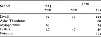
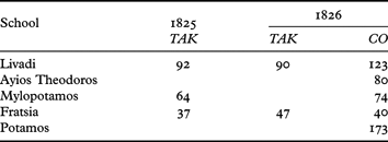
The Cerigo schools are stone-built, single rooms, with simple rectangular plans and high vaulted ceilings. They do not conform to the ideal proportions but tend to be narrower in relation to the length (i.e. approximately 3:1). Tables and benches were often included in the lists of items purchased for the schools in the account books, although the size and quantity were unspecified so that it is impossible to gauge how they were placed in the interior space. From school registers and education reports, the approximate number of pupils in 1825 and 1826, the time when the buildings were constructed, can be determined for the village schools (Table 6). The size of the buildings could easily accommodate the number of pupils with the appropriate numbers of desks and benches. The Livadi school has preserved evidence for what must have been a dais for the teacher at one end of the building – a slight stepped raised area at the west end. Other buildings may have had a dais, originally constructed in wood, which has disappeared over time. Although the schools' high vaulted ceilings conform to Lancaster's recommendations, the placement of the doors and windows do not. Doors are generally placed in the centre of one long side, not on a short side near the teacher's dais. The windows, regularly placed around the building, are large and are situated approximately at shoulder height. This is ideal for air circulation but not in keeping with local building practices as it admitted too much heat and light in a hot climate. The British engineer, Colonel C.J. Napier (Reference Napier1825, 58–60), in his memoirs of work on Cephalonia in 1824, stressed the importance of air circulation for health. Although he was speaking specifically of military barracks, he applied the same principle to any room where many were likely to gather. This may have included schools, particularly those constructed under the aegis of the British. Equally, the size and shape of the windows may have been dictated by architectural style.
Pupil numbers 1825–6 from school registers (TAK Uncatalogued 1825–8) and Colonial Office education reports (TNA CO 136/1366/690).
The architecture of the Cerigo schools is striking in comparison to existing architecture on the island. The ornamentation on the schools makes use of elements of the neo-Gothic and neoclassical genres, revivals of earlier architectural styles that were fashionable in British late Georgian architecture of the late eighteenth to early nineteenth centuries (Pevsner Reference Pevsner1964, 358). In the nineteenth century, neo-Gothic or Gothic Revival ‘drew strength from a generally patriotic attitude to the past’ expressing a belief that medieval Gothic had its roots in England and hence the English were heirs to the revival of that style (Bradley Reference Bradley2002, 325). By the 1820s, neo-Gothic architecture was also becoming a strong expression of conservative Christian style, as seen in the later works of Augustus Pugin and the Cambridge Camden Society (Borg Reference Borg2001, 83). Neoclassical architecture, on the other hand, symbolised many philhellenic sentiments, and was seen as the embodiment of order, truth and reason.
Under the leadership of Thomas Maitland, George Whitmore is credited with designing the first neoclassical public buildings constructed on Greek soil with the aim of restoring the Arts to Greece (Johnson Reference Johnson1987, 60). These public buildings were built on Corfu with imported stone and stonemasons from Malta between 1819 and 1824 (Borg Reference Borg2001, 37; Colvin Reference Colvin1978, 1112). In the absence of an architect, pattern books existed to aid the builder (e.g. Langley Reference Langley1794). As already indicated by Davy, Captain MacPhail had made use of a ‘cyclopaedia’ in planning the roads and bridges he constructed. Jones (Reference Jones1827 ii, 533) also mentions ‘plans’ given to workmen by MacPhail. It is conceivable that a pattern book could have been employed in designing and constructing the Cerigo schools.
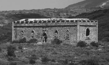
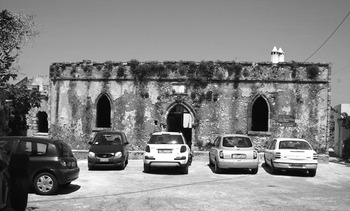
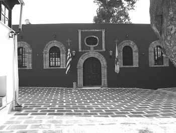
The neo-Gothic architectural embellishments of pointed (‘ox-eyed’) arches and crenellations are employed on the Livadi (Fig. 8) and Mylopotamos (Fig. 9) schools. The rounded (‘cavello’) arches on windows and doorways of the Fratsia (Fig. 10), Ayios Theodoros (Fig. 11) and Potamos (Fig. 12) schools are typical elements of the neoclassical style. The carved stepped entablature at the top of the walls of the Potamos school is also characteristic of the Ionic order, common in the neoclassical genre. It is almost certain that the population of Cerigo in 1825 would have recognised these structures as British and noticed they were different from existing built forms. In choosing these styles for the Cerigo schools, MacPhail stamped a British ‘trademark’ on the buildings, charged with British values. The two neo-Gothic buildings had marble dedicatory plaques, reinforcing this British connection at least in the Livadi school plaque, which cites Sir Frederick Adam, the Lord High Commissioner. The Potamos and Ayios Theodoros schools both have carved stone frames above their doors, which may originally have contained plaques. We do not know if the Hora school originally had this feature as well, though it is very likely for such a prominent school on the island.
Livadi school from the southeast (photograph by John Bennet 2007).

Mylopotamos school from the south (photograph by John Bennet 2009).

Fratsia school from the northeast (photograph by John Bennet 2009).

Ayios Theodoros school from the east (photograph by John Bennet 2009).

Potamos school from the south (photograph by John Bennet 2009).

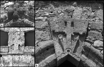
In three of the schools, Christian crosses appear above the entrance – all in different styles (Fig. 13). The cross over the Mylopotamos school (Fig. 13a) is a Maltese cross, which, in the early nineteenth century, was often used in British military insignia; moreover the emblem of the Order of Saint Michael and Saint George, founded in 1818 to commemorate the establishment of the Ionian protectorate, consisted of two Maltese crosses. The cross over the Livadi school (Fig. 13b) is a Latin cross with elaborate terminals, floré or three petal-like projections, on the ends of the shorter horizontal arm and at the top of the longer vertical arm. It rests on an object that could be identified as a set square, although the actual feature it represents is not clear. On either side of the cross, originating at its base, are diagonal lines, one terminating in an arrow and the other in a circle. This may possibly be an inverted mason's compass, although mason's compasses were more commonly represented with two pointed ends. To say that these symbols were influenced by Freemasonry is highly speculative, but it would not have been outside the realm of possibility as that society was particularly linked to public educational movements (Steele Reference Steele2007, 34–5). An Eastern Orthodox cross (Fig. 13c), distinguished by its additional shorter horizontal arm, resting on a triple mound symbolising the Holy Trinity, appears over the door of the Ayios Theodoros school. This specifically non-British symbol may have been chosen because of the location of the school in the courtyard of an Orthodox monastery, or is possibly a post-British feature introduced at a later date.
Crosses over school building doorways. Clockwise: a. Mylopotamos, b. Livadi, c. Ayios Theodoros (photographs by the author 2009).

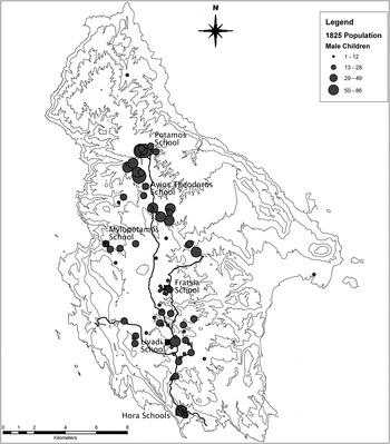
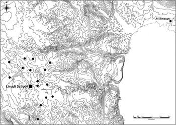
The built environment of the Cerigo schools encompasses the forms of the buildings and the activities employed therein, but also describes the spaces around and their interaction with the landscape. Joseph Lancaster, in his description of an ideal school, suggested that the schools be placed higher than the surrounding ground to promote dryness of the room and the health of the scholar (Lancaster Reference Lancaster1809, 65). He also prohibited placement of the entrance to the school directly onto a main road. For the most part, the Cerigo schools were placed on high ground and most were set off from the main roads. An exception to this latter rule is the Hora Central school, which appears to have been located on the main road from Kapsali to the Città of Hora. Practical reasons for placement of the schools throughout the island relate to population distribution and access. As we have seen, the construction of the schools coincided with the construction of roads on the island. The distribution of male children from the 1825 census (Fig. 14) shows the schools located close to concentrations of school-age boys. A detailed view of the catchment area of the Livadi school, determined from an 1826 school register that lists boys by village (TAK Uncatalogued 1825–8), shows the short distance travelled by boys from villages near to the school, with the exception of a few who travelled a longer distance from the new settlement at Avlemonas (Fig. 15).
The distribution of male children in 1825, based on census figures in the category of male children age 1 to 13 (TAK Απογραφή 1825), and major British-period roads (TNA MFQ 1/673/7).

The Livadi school catchment area based on the 1826 school register, indicating the residences in relation to the school.

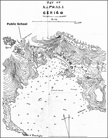
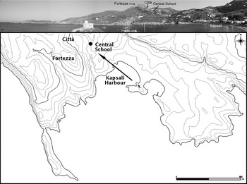
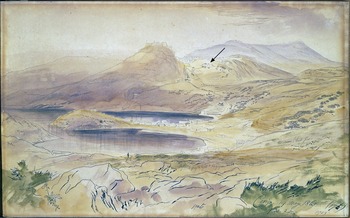
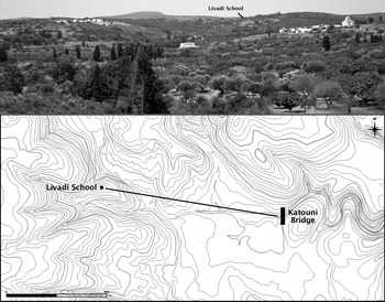
The planning and construction of the schools also involved situating the schools in specific significant spots in the landscape to maximise their visibility – physically and ideologically. The Hora Central school is situated directly above the approach to the island from the sea – on the road from the harbour of Kapsali to the fortress and town (Figs. 16, 17 and 18). It would have been noticeable on the hill from ships as they came into the harbour. Similarly, the Livadi school at Milapidea is a conspicuous landmark high on a hill to the west of the main north–south road of the island. This neo-Gothic building looks directly down the valley towards the impressive bridge at Katouni (Fig. 19, see also Fig. 6). From a viewpoint at the centre of the Katouni Bridge, the school can be seen face on, and it is possible that the two structures were purposely aligned, since they were constructed within a year of each other. The Potamos school, on a hilltop on the east side of the town, also has a relationship with the similar, though smaller, British-built bridge on the Potamos road. The construction of the bridge and the school are recorded in the same financial reports for 1826. The front of this school would have been directly ahead and clearly visible when crossing the bridge, although it is now obscured by a large recently-built retirement home on the slope in front. The Fratsia school was placed in an open, central location at a crossroads in the middle of the island. Since most of the buildings presently near the Fratsia school post-date its construction, it is quite possible that the school would have originally been in an open area between the multiple parishes that made up the town.
British map of 1842 showing the placement of the Hora public school (TNA MFQ 1/142/1, C. Bay of Kapsali. Crown copyright, with permission of The National Archives).

Location of the Hora Central school (present primary school) as viewed from Kapsali. Photographic panorama taken from the ‘x’ on the map (photograph by John Bennet 2009).

Watercolour by Edward Lear (Gen. No. 145), Cerigo 1863, of a view from the harbour of Kapsali to the town showing the location of the Hora Central school (indicated by arrow). With permission of The Gennadius Library, American School of Classical Studies at Athens.

Livadi school from the Katouni bridge (photograph by John Bennet 2009).

The symbolic significance in the placement of schools should also be taken into account. The school that most embodies this concept is that at Ayios Theodoros. Situated in, and indeed part of, the monastery, Ayios Theodoros is a key location in the ethos of the island community. Conventional lore tells how the saint, Ayios Theodoros, a hermit monk, lived and died on the island (ad 920–44) at a time when it had been devastated by Saracen pirates and deserted. Later, in more secure times, a hunting party of Byzantine Greeks from the town of Monemvasia in the Peloponnese discovered his skeleton. The saint's bones duly became holy relics and a monastery was established at the site of his burial. Soon thereafter, settlers came from the Peloponnese – many from Monemvasia – founding the town of Palaiochora (Ayios Dimitrios) not far from the monastery, beginning the repopulation of the island and associating it with the cult of this saint. Constructing a British school in this public location reinforced connections between local traditions of the island and new British establishments.
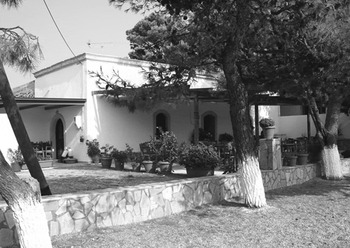
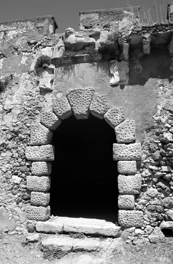
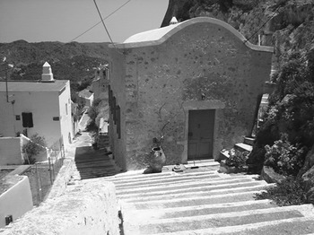
The Mylopotamos school was placed in front of the entrance to the Venetian fortress with its parish churches and houses that were still occupied in the British period. It partly obscures the monumental gateway surmounted with the emblematic Venetian lion (Fig. 20, also see Fig. 9), supplanting the older, rival imperial monument. Ayios Minas, the secondary school in Hora, was situated next to a disused Roman Catholic monastery reclaimed by the British as a place to bury their dead (Fig. 21). The female school in Hora epitomises private space. The role of women in the nineteenth-century Ionian Islands, as suggested by Gallant (Reference Gallant2002, 161), can be seen as similar to that of women studied in the anthropology of traditional Greece of the recent past, where private/domestic space is often interpreted as female domain while public/outside space is that of males. The female school is tucked away against the wall of the fortezza at the narrow entrance to the meso-borgo (lower town) of Hora (Fig. 22) surrounded by domestic buildings. It is also the only British school constructed between 1824 and 1826 that probably was not a purpose-built structure, but a renovation of an existing domestic structure given the short ‘construction’ time recorded (TAK EK4, f. 10), its low cost, and the subsequent rent payments.
Monumental archway to the Mylopotamos fortress (Kato Chori) surmounted by the Venetian lion (photograph by John Bennet 2009).

Document showing the location of the school at Ayios Minas within the Convent of S. Martin (Martino) with the areas of British burial grounds marked out as (a) and (b) (TNA MPH 1/886/7, Crown copyright, with permission of The National Archives).

Hora female school from the north (photograph by the author 2009).

TRANSPOSITIONS: DYNAMICS OF THE CERIGO SCHOOLS
William Whyte (Reference Whyte2006, 153) has pointed out that ‘as a building is planned, built, inhabited, and interpreted, so its meaning changes’ and that these changes – or transpositions – are significant sources for historical interpretation. As I have tried to show, when first planned and constructed the Cerigo schools were emblematic of a British system, influenced by missionary principles. The details of how the schools on Cerigo weathered subsequent changes are unclear, but local changes in the functioning of the schools echoed, to a certain degree, the events on the other Ionian Islands and the mainland of Greece. Transpositions in the Cerigo schools can be detected in the available data as occurring at specific times – the first during and immediately after the Greek War of Independence (late 1820s/early 1830s), and the second in the late 1830s to early 1840s.
In the late 1820s, the Lancastrian schools of Cerigo received special mention in contemporary publications as outstanding examples of the promotion of education in Greece. Edward Blaquiere, the philhellene who had sent Greek boys to be educated in London, praised the Ionian efforts in schooling and cites Cerigo and MacPhail's achievements in particular (Blaquiere Reference Blaquiere1828, 33–4). Rev. Wilson, in his narrative of sixteen years as a missionary to the Mediterranean also singled out MacPhail and the schools he ‘so ardently patronised’ on Cerigo (Wilson Reference Wilson1839, 222). Reports of these educational achievements on Cerigo had also reached as far as the United States – through missionary channels – and were reported in a periodical publication for teachers (Pankhurst Reference Pankhurst1827, 64). Their significance – like that of the other Ionian Lancastrian schools – was in their evangelical foundation, not only as representative of a zealous Protestant belief in the authority of the Bible, but also as a means to foster respect for political authority and instil a work ethic among the population (Thorne Reference Thorne1999, 124).
When the first British missionaries turned their attention to the Mediterranean, soon after the end of the war with Napoleon in 1815, their objectives were ‘… the Acquisition of Information relative to the state of Religion and of Society, with the best Means of its Melioration – and the Propagation of Christian Knowledge, by the Press, by Journeys, and by Education’ (Jowett Reference Jowett1822, v). With intense interest at home, numerous encyclopaedic publications by missionaries and ecclesiastical travellers followed (e.g. Jowett Reference Jowett1822; Hartley Reference Hartley1831; Waddington Reference Waddington1829; Wilson Reference Wilson1839; Yeardley and Yeardley Reference Yeardley and Yeardley1835) and a steady flow of correspondence was printed in newly established missionary journals (Johnston Reference Johnston2003, 19; Wolff, North and Deering Reference Wolff, North and Deering1976, 705). Official Colonial Office language is very similar: the key to reforming the Greeks was through education, reformation of the church, and the cooperation of ‘respectable and influential classes’ (Gallant Reference Gallant2002, 178; TNA CO 136/1318).
Missionary work in the eastern Mediterranean was a ‘two-phased plan’ to convert the generally non-Christian populace of the areas where Christianity began and first developed, in Palestine and the Near East (Augustinos Reference Augustinos1986, 129–30; Erhan n.d., 316). However, before the conversion of non-Christian populations of the Near East could take place, the first phase was the improvement of the Eastern churches, which were perceived as having sunk into a state of ignorance and spiritual degradation. Therefore, a principal aim of the missions to the eastern Mediterranean was to revive what they considered to be the ‘pure religion’ among the Greeks (Lovett Reference Lovett1899, 636). Greece was thought to be the centre for the rejuvenation of religion in the East and from here word would spread to Turkey, the Levant, Egypt, and further afield, or, in Rev. Wilson's (1839, 225) own words: ‘upon the pillars of Greece hang the keys of the east, and from that land will the word of the Lord go forth to all Asia’.
Although hampered by the Greek War of Independence, The Missionary Gazetteer indicated in 1825 that ‘Missionaries are on the out-posts, waiting the indications of Providence to go forward and possess the land’ (Chapin Reference Chapin1825, 370). One of these ‘out-posts’ was the Ionian Islands. William Allen had in mind an educational system set up in the Ionians that would ‘act powerfully upon all Greece’ (Gilpin Reference Gilpin1847 i, 442). Rev. Wilson also believed education to be the key:
… education of the young may be a slow method of converting man from sin and idolatry, but it is often sure; and much mature reflection has led me to the conclusion that it is the means to which God, in these latter days, has most attached his blessing. (Wilson Reference Wilson1839, 185)
His colleague the Rev. Lowndes recorded in his journal on 4 August 1819 a similar conclusion in seeking ways of inconspicuously carrying out his ‘missionary labours’ in the Ionian Islands through active participation in Bible Societies and in education (SOAS Lowndes 1819).
Integral to the spread of Protestant morals espoused by the missionary educational endeavours was the movement of temporary residents to the Ionian Islands in the wake of the turbulence caused by the War. On Corfu, the Committee for the Relief of Captive Greeks had formed a school by 1827 for refugee children, placed under the charge of Rev. Lowndes (Missionary Register 1833, 236). Similarly, refugee children from the neighbouring Peloponnese and Crete are mentioned in the 1825 school registers for the Cerigo schools (Harou-Koronaiou Reference Harou-Koronaiou1989c; Reference Harou-Koronaiou1990a; Reference Harou-Koronaiou1990d). On his visit to the island in 1827, John Davy (Reference Davy1842 ii, 113) comments that the ‘scholars were principally the children of refugees from the Morea, then invaded by the Egyptians under Ibrahim Pasha, and from the islands of the Archipelago’. Davy indicated that these children had been on Cerigo for two to three years and had made great advances in their education, remarking on their industrious manner of applying themselves to their work. Also according to Davy, the female school on Cerigo, from its founding in 1825, consisted primarily of refugees from Cyprus, Rhodes, Crete, Scio, Smyrna, Hydra, and various islands as well as Sparta, Argos, Athens, Corinth and other parts of the Peloponnese. By 1830, BFSS accounts indicate that the female school on Cerigo had broken up and each girl was ‘required to copy with her own hand the sewing system, and was thus enabled to introduce it to wherever they might be established’ (BFSS QE 1831, 57). This principle was applied to the boys as well: that they would take the rudiments of learning – and presumably knowledge of the Scriptures – back into the communities from which they had originated.
Of the early British-period censuses of Cerigo held in the TAK, the 1822 and 1833 censuses are useful in determining details of the movement of people onto the island (Table 7). The 1822 census includes a list of the Carte di Sicurezza, permissions for the right to remain on the island, organised into categories by name, occupation, place of origin and the number of people in each group. Of the total of 988 persons, more than half, 451 in 96 groups (most likely families), came from Smyrna (İzmir) in Asia Minor, a city where the Greek community had been under threat from the very beginning of the War of Independence in 1821 (St. Clair Reference St. Clair2008, 25). More significant are the 110 people in 23 groups – out of the 150 individuals from the Aegean Islands – listed as coming from Scio (Chios), an island where many Greeks were massacred in the same year. Therefore, it is likely that the majority of these individuals in the list of the 1822 Carte di Sicurezza were refugees. Although the location on the island of these ‘foreigners’ (forestieri) is not always listed, it is clear that they were settled in most parts, but the majority were located in the neighbourhoods of Hora. The predominant profession for all the ‘foreigners’ listed in 1822 is that of merchant (Mercante), with priests (Religiosi) second.
Origins of foreigners on Cerigo from the 1822 and 1833 censuses in the TAK (TAK Απογραφή 1822; TAK Απογραφή 1833).

The 1825 census lists foreigners at the end of each district, but does not list any other information about the individuals. According to this census, the majority (699) of foreigners in 1825 were located in the Città of Hora. The 1833 census does not include a list of Carte di Sicurezza or lists of foreigners; however, this census is quite detailed in the type of information it contains, including a column for Patria or ‘homeland’. Data are preserved for the whole of the island except the northern district of Potamos, though this is unlikely to seriously affect the overall number of non-locals resident on the island in 1833. This census shows that many of those who originated off island are married to local Cerigo men or women and a few have the annotation Naturalizato, denoting that they have become naturalised citizens. Professions are more diverse in 1833, including merchant, tailor, clerk, cobbler, gold smith, copper smith or locksmith, cook and teacher. Table 8 shows the distribution of ‘aliens and resident strangers’ by district between 1825 and 1834 from Colonial Office population reports. The peak in numbers seems to be between 1825 and 1827 with a fall-off in 1828 and 1829. It is interesting that in 1833 and 1834 there are none listed for the island in these official reports, possibly indicating that the individuals with a Patria other than Cerigo in the 1833 census had conceptually become incorporated into the island community or were not considered in the same category as the ‘foreigners’ who came to the island in the wake of war.
Aliens and resident strangers 1825 to 1834 from the 1825 censuses in the TAK (TAK Απογραφή 1825) and the 1826–34 population reports in the Colonial Office financial returns (TNA CO 136/1366/690).

Population figures for Cerigo from 1826 to 1859, excluding the island of Cerigotto (Antikythera), show a sharp decline after 1828 with the departure of temporary refugee residents, a levelling off in the 1830s, and a steady rise into the mid-1840s, jumping up in 1844 and then steadily rising again into the 1850s (Fig. 23). If we compare this with the percentage of the population in government-subsidised schools and the total numbers of schools on the island (excluding Cerigotto), we see the first change in the operation of the schools in the late 1820s, when departing refugees cause acute fluctuations in the percentage of the population in school. Deficiencies in record keeping can also be detected at this time, particularly in 1828 and 1829 when several schools are not included in the official education reports.
Percentage of the overall population in Cerigo public schools during the period 1826–59 (line in lower graph) compared with the number of public schools on the island (shading in grey in lower graph) and the demographic trend (line in upper graph). The percentage was compiled using the standardised number of pupils in Table 3 and population totals reported in the annual financial returns for the island (TNA CO 136/1366/690–2). The figures – population, pupil numbers and total numbers of schools – exclude Cerigotto (Antikythera).

The second change in the operation of the Cerigo schools, a more subtle transposition, can be detected by examining these same Colonial Office education and population reports (Fig. 23). New Lancastrian public schools (see Fig. 3) were established in 1830 at Karavas in the extreme north of the island and in 1836 on the island of Cerigotto to the south. In the middle of the island, the school at Mitata was established in 1835. Ayios Theodoros ceases to be mentioned in the education reports after 1839, but a new school in nearby Aroniadika takes over in 1840 (see Table 4) – with the same teacher and number of pupils (TNA CO 136/1366/691). No new public Lancastrian schools were established on Cerigo after 1840 for the remainder of the British period.
From 1830 until 1841, we see an average of 6% of the overall population in school, just after the establishment of the schools at Karavas, Mitata and Aroniadika and at a time when the population was slowly rising. In the years 1839 to 1841, the numbers of students in school are estimated given the under reporting of schools in the education reports. This represents a second time of disruption, coinciding with the cessation of the Ayios Theodoros monastery as the location of a public school. Shortly after this second change in the operation of the Cerigo schools, we see a minor decline in the percentage of students in schools (average of 5% from 1841 to 1859) against an increase in population in the same period. This possibly reflects a lack of confidence in the government-sponsored schools rather than simply a factor of demographics in the number of school-age children in the total population.
This second change in the Cerigo schools coincides with the period when missionaries were beginning to question whether the Ionian Islands were a ‘favorable location for missionary operations for the benefit of the Greek race’ (Arnold Reference Arnold1845, 283). The LMS closed their mission station in the Ionians and Malta in 1844 (Lovett Reference Lovett1899, 640). Gallant (Reference Gallant2002, 175–209) described an impasse in relations at this time between Ionian Greeks and British as each saw themselves as the ‘real’ Christians. Local priests on Zante attempted to discourage pupils from attending British schools, indicating that they were teaching ‘Methodism’, particularly in the wake of the distribution of religious tracts in schools (Gallant Reference Gallant2002, 189). Tension in the Ionian Islands also erupted over Lowndes' appointment as inspector-general of schools. In a proclamation, Promemoria, written by the Ionian scholar Chevalier Mustoxidi in 1839, Lowndes was singled out – without referring to him by name – and described as a ‘Baptist Missionary; a man ignorant of our character, our habits, our religious rites, and our language, [who] is appointed to superintend the education of the rising generation’ (Papanicolas Reference Papanicolas1851, 48). The response to the distribution of religious tracts in the schools by missionaries eventually led to violence. In 1850, a mob of local men on Zante attacked the houses of those Greeks who converted to Protestantism and those who taught in Lancastrian schools, burning many books in the process (Baptist Missionary Magazine 1842, 166; Gallant Reference Gallant1990, 491; 2002, 189). A similar protest letter published in Cephalonia, translated and printed in The Baptist Missionary Magazine of 1851, described teachers in the Lancastrian schools as preaching ‘Luthero-Calvinist heresy’ (Arnold Reference Arnold1851, 19–20).
Further contention came from comparisons with Free Greece, where national identity had become entwined with religion (Gallant Reference Gallant1990, 490–1). Effie Gazi (Reference Gazi, Beaton and Ricks2009, 100), in her discussion of this link between nationalism and religion, remarked on the growing ‘Orthodox fervour’ in Free Greece beginning in the 1830s which eventually led to anti-proselytism laws, culminating in the 1852 trial in Athens of the American missionary Rev. Jonas King (Baird Reference Baird1856, 355–67). In his history of the American missions to the eastern Mediterranean, Rufus Anderson (Reference Anderson1872, 147–8) attributed the increase of ‘jealousy of the [Orthodox] clergy’ to the establishment of the autocephalous church, the separation of the Church of Greece under the reign of King Otto from the control of the Patriarch at Constantinople (Tracy Reference Tracy1842, 277–8). Under King Otto, a national school system was also established – on 15 March 1833 – originally employing the monitorial system, although this was abandoned in 1842 in favour of a French system of education (Wilcox Reference Wilcox1933, 7). The curriculum included the more accepted Orthodox religious instruction overseen by the Greek clergy, who also had right of approval for all religious literature used in schools (Johannis Reference Johannis1862, 576). Some contemporary British and American accounts, when describing this new educational system, tended to gloss over the religious issue by stating that the 1833 national school system of Greece employed the Lancastrian method and indicating there was some (unspecified) religious instruction (SDUK 1834, 161; Earle Reference Earle1840).
Prior to 1833, attempts to formalise public education in Greece had been made that mirrored contemporary educational efforts in the Ionian Islands. During the War of Independence, foreign philhellenes, particularly under the leadership of Leicester Stanhope, instigated the establishment of Lancastrian schools in Greece (St. Clair Reference St. Clair2008, 188–9; Wilcox Reference Wilcox1933, 6). Under the government headed by Ioannis Kapodistrias, public ‘Kapodistrian’ schools – employing a mutual instruction method – had been established as early as 1828Footnote 12 (Johannis Reference Johannis1862, 573; Saloutos Reference Saloutos1955, 159; Tracy Reference Tracy1842, 219; Wilcox Reference Wilcox1933, 6–7). British and American missionaries such as Mr Hildner and Dr Korck on Syra, and J.H. Hill and Dr King in Athens, were also active at this early stage in the formation and running of Lancastrian schools for both boys and girls. Missionary presses supplied books; one record in the LMS archives indicates that books were sent to Dr Korck for Count Capo D'Istria (i.e. Kapodistrias) on 11 April 1828 consisting of 480 Anglo-Greek Primers, 58 spelling books (with 50 more sent on 20 April) and 250 tracts (SOAS Wilson 1828–30). Schools under missionary control within the borders of Free Greece, however, were shut down by the 1840s after the civil law outlawing proselytism was passed (Gazi Reference Gazi, Beaton and Ricks2009, 100). Indeed, many missions were discontinued in the eastern Mediterranean at this time (Augustinos Reference Augustinos1986, 138).
Throughout the British period, Cerigo seems to have followed a similar pattern to the rest of the Ionian Islands. In 1823, Captain Jones (Reference Jones1827 ii, 533) noted that the Greek clergy were not opposed to the establishment of Lancastrian schools, but they ‘have not exerted themselves in their favour’. Additionally, at least two of the teachers in the public schools in the 1820s were Orthodox priests and taxes to support the schools were, in part, coming from the Church. However, later tensions were displayed more explicitly with the cessation of the school at the Orthodox monastery of Ayios Theodoros. Also, alternative accounts of the Hora female school were published in the 1832 and 1835 Ionian Island Gazettes (Leontsinis Reference Leontsinis2000, 329), stressing that it was established in 1826 as a private school, funded entirely by voluntary contributions by the islanders and administered by a committee of local noblewomen. These accounts, almost certainly, are skewed to highlight Cerigote philanthropy, excluding British involvement, at a time of heightened tensions resulting from the establishment of a Greek state.
This revisionist form of history can also be seen in late nineteenth- and early twentieth-century Greek histories of education in Greece written for English-speaking audiences. It is not surprising that the role of foreign – particularly missionary – involvement in the development of schools is ignored. There is, however, an acknowledgement that public schools were established in the Ionian Islands in the early part of the nineteenth century. In an article of 1862 on public instruction in Greece printed in an American educational journal, Philipos Johannis (Reference Johannis1862, 573) stated that Dr Athanasios Politis had been responsible for introducing monitorial-style teaching to the Ionians and that the Ionian government established a number of schools based on this system. This statement is repeated in a paper written by John Gennadius (Reference Gennadius1925, 16 n. 24) for the first biennial conference of the World Federation of Education Associations held in Edinburgh in July 1925, stressing the Greek term for the mutual instruction system – αλληλοδιδακτική. Despite the interpretations of Johannis and Gennadius, it is clear that the development of the educational system in the Ionian Islands and Greece owed a debt to the activities of early Protestant missionaries sent to the Mediterranean. Gazi (Reference Gazi, Beaton and Ricks2009, 101) has argued that the mission to convert Christians by Christians actually took the form of a transformation to an enlightened state with its ‘diffusion of nationalism and middle-class values and practices’ rather than simple conversion from Orthodox to Protestant, or what Gerasimos Augustinos (Reference Augustinos1986, 140) described as the missionary's ‘significant contribution to the development of a bourgeois stratum’. These middle-class aspirations, connected to democratic national movements, included the desire for a public educational system (Steele Reference Steele2007, 9).
The Cerigo schools can be viewed as a microcosm of British colonial and missionary involvement in the Ionian Islands that reflects wider political and social changes taking place in the western European world of the early to mid-nineteenth century and an increasing alignment with the ideologies of the developing nation-state of Greece. Developments in Greece and subsequent British policies are reflected in two changes within the functioning of the Cerigo schools. The first change was the disruption caused by refugees – arriving and departing – at the end of the 1820s. The second was brought on by the increasing tensions manifested in religious differences between Protestant and Orthodox participation in, and control of, education.
POSTSCRIPT
A detailed look at the establishment and operation of the Cerigo schools shows some aspects of the complex relationship between ‘coloniser’ and ‘colonised’. For example, although ‘foreign’ (i.e. non-Kytheran) teachers taught in the main town of Hora, many of the teachers in the village Lancastrian schools were local men and at least two were Orthodox priests. Also, contrary to missionary assertions, the teacher in the female school was a local woman. On the other hand, many of the textbooks initially used in the schools were sent by missionary presses or from the BFSS, with a stress on the use of Bible lessons and moralising tales. British imperial elements are evident in the architecture and placement of the buildings constructed in 1825–6. Yet their construction seems to have been carried out with willing participation and contributions by local communities and individuals. Subsequent changes in the running of the schools reflected broader events in the Ionian Islands and Free Greece, with increasing hostility to British rule and missionary endeavours.
After unification with Greece in 1864, the original school buildings were, for the most part, systematically abandoned, although not immediately. The Central school building at Hora is an exception as it has seen continuous use down to the present, although modified and rebuilt over time, obscuring the original architecture. In two cases – at Fratsia and Potamos – the school buildings were in operation until modern primary schools were built alongside them early in the twentieth century. The Potamos school continued to function in the early twentieth century as a secondary school and community meeting place after that (Harou-Koronaiou Reference Harou-Koronaiou1990a), and was recently (post-2004) partly restored and a performance platform erected in front. The others were only abandoned when schools in their catchment villages were constructed in the early twentieth century. Today the surviving buildings are prominent features in the landscape of the island and some have been put to various uses – the Hora female school is a private home, the Livadi school is used for informal agricultural storage, and the Fratsia school has been converted for commercial use. Local pride in their heritage has also led Kytherans periodically to call for the restoration of the most splendid of the British-built schools, at Livadi (Harou-Koronaiou Reference Harou-Koronaiou1989a). The buildings are now remembered as the places that once educated the youth of the island, constructed with Kytheran philanthropy, labour and skill.