


During the First Federal Congress of the United States (1789–91), legislators confronted one of the most vexing questions facing the new country: where to locate the seat of government. In the course of the lengthy and contentious congressional debate, James Madison articulated the principles he thought should guide the decision, arguing that in a republican government the principle of “equal right” must obtain in all matters, including the location of the capital. The operation of this principle, he noted, has been “fully exemplified in what has taken place in the several states. In every instance where the seat of government has been placed in an eccentric position, we have seen the people either successfully or unsuccessfully struggling to place it where it ought to be” (September 4, 1789; Bickford, Bowling, and Veit Reference Bickford, Bowling and Veit1992, 1434–35). To illustrate his argument about ascertaining the “correct” location of the capital, Madison offered the example of his native Virginia, which moved the state capital from Williamsburg to Richmond in 1780, as well as those of North Carolina, South Carolina, New York, and even tiny Delaware, all of which had recently moved their capitals.Footnote 1
But where “ought” a capital be located? Once again, Madison offered an argument derived from the republican principle of equal representation: “It is important that every part of the community should have the power of sending, with equal facility, to the seat of government such representatives to take charge of their interest as they are most disposed to confide in,” he explained, adding that if the capital is located elsewhere, “You do therefore violate the principle of equality, in a part which is peculiarly vulnerable” (September 4, 1789; Bickford, Bowling, and Veit Reference Bickford, Bowling and Veit1992, 1436). Madison thus analyzed the “correct” location of the capital in terms of equal access to the seat of government by the citizens. Therefore, although the story of the choice of Washington, DC, as the nation's capital is usually portrayed as either a compromise between North and South or as a log-roll over the federal assumption of state debts, could it be an accident that the choice of the seat of government was about 60 miles from the population center of the United States at that time?
In this article, we investigate capitals as a representative institution by examining whether the choice of their location follows a systematic pattern in accord with the theory of representative government developed in the newly independent United States and articulated perhaps most fully by Madison. In particular, we examine the location—and relocation—of state capitals in the United States, as well as the location of the federal capital itself. In this regard, we note that the choice faced by Madison and his fellow representatives in the fledgling country was far from unique. No fewer than 11 of the original 13 states decided to relocate their capitals within the first 30 years of independence, and states that later entered the union all faced the question of where to establish a permanent capital. In addition, the location of many state capitals changed over time. A number of states have had two capitals, Illinois and Pennsylvania have had three each, California four, Tennessee five, and Georgia no fewer than seven. This capital mobility enables us not only to more sensitively test the systematic character of decisions on capital location but also to do a separate analysis of the pattern of capital relocation.
Our analysis of capital location and relocation contributes to the study of institutional design and change, especially in the area of American political development, as well as to a burgeoning literature on the effects of geographical factors on political outcomes. Scholars have long pointed to variation in the design of political institutions as crucial to understanding the political and economic performance of states (e.g., Cox and McCubbins Reference Cox, McCubbins, Haggard and McCubbins2001; North Reference North1990). For this reason studying the origins and evolution of political institutions occupies a significant place in political science. The flux of representative institutions in the early United States, including the mobility of political capitals, provides an opportunity to assess the extent to which the design of political institutions corresponded to representative principles. As such, our article offers new insights into the study of American political development in particular. The notion that capital locations should adhere to representative principles was part of a larger, sweeping revolution in the theory and practice of representative government that took place in 18th and 19th centuries (e.g., Wood Reference Wood1969; Zagarri Reference Zagarri1987). Although scholars in political science and history have investigated the development of representative institutions in the United States, the subject of capital location as a critical feature of this development has largely gone unnoticed (for an important exception, see Zagarri Reference Zagarri1987, Reference Zagarri1988). Importantly, unlike the study of many other changes in political institutions, analyzing capital locations has the distinct advantage of being a subject we can precisely measure.
Finally, our article also contributes to a nascent but growing literature that examines the impact of geographic factors, including distance, on political representation and economic development. For example, scholars of early European state formation have found that variation in the proximity of representative assemblies to the populace directly influenced political development, giving some states a head start over others with respect to economic development (e.g., Stasavage Reference Stasavage2010). Similarly, recent research on the American states has shown that, at least in the modern era, states with capitals proximate to population centroids have lower levels of legislative corruption and higher levels of citizen participation (Campante and Do Reference Campante and Quoc-Anh2012). Despite the ways in which capital location seems to matter for political and economic outcomes, the issue of why capitals are located where they are has largely remained an open question. Our analysis of the choice of the location and relocation of capitals in the United States within the theoretical context of an understanding of capitals as representative institutions joins this burgeoning literature about the impact of geographic factors to a theoretical foundation grounded in the study of institutions and institutional change.
CAPITALS AS REPRESENTATIVE INSTITUTIONS
We may not immediately think of capitals as representative institutions. But the framers of the newly independent states and then the federal government in the United States began to conceive of the location of capitals in light of the principles of equal representation of individuals. In doing so they broke with customary understandings of capital cities. Traditionally capital cities had been centers of sacred or traditional authority for empires, states, and other political entities, although they had not always been the seat of government (Rapoport Reference Rapoport, Taylor, Lengellé and Andrew1993). Capital cities were historically the chief cities of a political entity, as indicated by the fact that the word “capital” is derived from the Latin caput or “head.” Babylon, Jerusalem, Rome, Tenochtitlán, Paris, and London are examples of such capital cities. Even in states with representative institutions, such as England, neither the meeting place of the parliament nor the location of the royal court were considered as a permanent seat of government, much less in terms of representative institutions.
The understanding within representative democracies of capital cities as representative institutions, and therefore the question of their location, becomes clearer when compared to capital location in other political systems.Footnote 2 Scholars who have examined Europe, for example, have suggested that the process of state formation, culminating in the Westphalian system, critically depended on the development of cities, especially what would become capital cities, as centers for concentrating capital and coercive means (Tilly Reference Tilly1990). In the European experience, therefore, capitals were effectively “chosen” by the successful monopolization of control centered in cities such as London, Paris, and Berlin. In this regard, the choice of Bonn as the capital of West Germany after World War II provides the exception that proves the rule.
By contrast, scholars of state-building in former colonial states such as those in Africa have argued that there is a different relationship between capital cities and the territory of the state in comparison to Europe. Given that the geographic entity of the state was created before the growth of effective state structures, the choice of capital was therefore determined by the convenience of the colonizers and not by the formation or the needs of the state itself, much less by concerns about representation (Herbst Reference Herbst2000, 15–21). Various explanations for such siting decisions have been offered, including the preferences of autocrats, who located the seat of government in their own ethnic region for purposes of both security and dominance, as in Nigeria or Malawi (see Potts Reference Potts1985), rational-technical arguments concerning the need for more suitable economic and political administration, as in Brazil (see Scott Reference Scott1998), or the imperatives of state- and nation-building in securing control over and the loyalty of the population, as in Kazakhstan (Schatz Reference Schatz1994). In none of these cases, however, have capitals been considered as an issue of representative government. In this regard, then, they are similar to the colonial capitals in what would become the United States. However, although most newly independent states in Africa or elsewhere have retained their colonial capital, more than a dozen states have decided to relocate their seat of government since the early 1960s (Hall Reference Hall, Taylor, Lengellé and Andrew1993, 82–3; Schatz Reference Schatz1994, 113).
The difference in the meaning of a capital in relation to political system or regime is illustrated by the case of the United States itself, for the newly independent states broke from their colonial heritage in questions of representation and other political institutions. First, in the colonial era, as with England, representation in legislative assemblies was organized in terms of corporate entities—towns, shires, and universities in England and generally towns or counties in the colonies—as opposed to representation of individuals (Rehfeld Reference Rehfeld2005, chap. 4; Zagarri Reference Zagarri1987, 36–42). Second, the system of territorial representation of corporate entities combined with the forces of royal charter, chance, and convenience did not dictate any systematic way to locate the seat of government. In a number of colonies the seat of government moved or rotated among towns, reflecting the underlying conception of corporate representation. Notably, in Rhode Island the practice of alternating meetings of the assembly among the principal towns continued after independence and all the way until Providence became the permanent capital in 1901. Colonial capitals therefore either obeyed the laws of royal dictate, or they drifted about until increasing settlement forced the choice of a permanent seat, with the victor typically being the largest or most conveniently situated settlement (e.g., New York, Philadelphia).
At the time of the Revolution, the incipiently independent states began to reconceptualize and reform their institutional inheritance in accordance with the principles enunciated in the Declaration of Independence (see Lutz Reference Lutz1988). Most important, according to Wood (Reference Wood1969, esp. 170–73, 181–88), was a change in the conception of representation from “virtual” representation, as of the colonies as units of Britain or of towns in the colonial legislature, to “actual” representation as proportioned to population, including ultimately universal enfranchisement. These changes in the principles of representation found expression in the practical design of new political institutions. As Zagarri (Reference Zagarri1987, 8) states, “Inspired by revolutionary ideas of equality and natural rights, citizens wrote new state constitutions and reshaped their institutions of representative government.” Among these institutions was the choice of the seat of government. According to Rehfeld (Reference Rehfeld2005, 70),“The founders . . . took the existing system of territorial representation and massaged it to serve the more important ends of developing theories of political representation, particularly the idea that persons, and not places, were to be represented.” This reconceptualization had immediate consequences: In the founding period no fewer than 11 of the original 13 colonies decided to relocate their seat of government. The fact that the former colonies—as well as states that later entered the union—relocated their capitals is testimony to the new conception of representation of people, not place.
In sum, along with adapting existing political institutions and practices they inherited from the colonial past, such as by writing new state constitutions or reapportioning legislatures, legislators and citizens in the new republic reconceived of the seat of government as a representative institution that had to conform to the principles of the natural rights of life, liberty, and the pursuit of happiness. These principles guided the decisions to locate or relocate the capitals of the original colonies and newly admitted states during the period of the early republic and over the course of the next century or more.
TESTABLE PREDICTIONS
The preceding discussion suggests that capitals were located to achieve representative principles. But what does equal access to the seat of government mean in practice? What location would maximize representation? There are at least two potential locations that might do so: the geographic center or the population center of the nation or state. Although in practice the geographic and population centers may overlap, there is no a priori reason to believe that they will be the same. If legislators and other relevant political actors were concerned about representation of individuals rather than localities, as we have seen was the case in the early republic, then they should have privileged the population center in the choice of capital location because it maximizes the minimal distance for the greatest number of individuals. Our general hypothesis is therefore that they should place the capital as close as possible to the population center, as opposed to placing it as close as possible to the geographic center, not to mention as opposed to placing it at random. However, in testing this hypothesis we have to confront the fact that in cases when the population and geographic centers are relatively close, we cannot determine which target they were aiming at. We therefore have the following testable hypotheses with regard to both the original location of capitals and their relocation:
H1: When the population and geographic centers are close, the capital will be placed near both.
H2: When the population and geographic centers are distant, the capital will be placed closer to the population center than the geographic center.
We designed our analyses to determine whether the location and relocation of capitals follow a systematic pattern in accordance with these hypotheses.
Before turning to our analyses of capital location, we note that we cannot directly test whether representatives and other political actors who chose where to locate a capital were doing so because the theory of representative government dictated that they ought to place it close to the population center. Although Madison and his fellow representatives in the First Congress, and other political actors at the state level, claimed that their decision should be guided by the principles of representative government and justified their own views on the location of the capital in these terms, certainly less principled “political” factors may have also been at work. As such, we can only determine whether choices about capital location were consistent with the hypotheses generated by the principles underlying the understanding of capitals as representative institutions. That said, the debates and decisions over capital location at the federal and state levels were themselves structured by these same principles of representative government. In other words, even if a decision reached in legislative assemblies (or by popular ballot in a few cases) was in part a compromise among legislators interested in maximizing their own proximity to the capital, the fact that the outcome was typically near the population center was itself due to a commitment to equality of representation or voting within government. The proximity of the capital to the population center would therefore either be a direct or indirect effect of adherence to principles of equal representation in all representative institutions, including the seat of government.
CHOOSING THE NATION'S CAPITAL
We began this article with the best known and historically most significant example of a decision during the founding period over where to locate the seat of government: the debate in the First Federal Congress over the permanent location of the federal capital. In this section we analyze the decision to locate the national capital in Washington, DC, as an initial and important test case of our examination of capitals as representative institutions. We highlight Madison's arguments about how the principles of representative government should be applied to the question of the location of the capital, because he was an especially articulate spokesman for a more widely held understanding of representative institutions. We do not mean to suggest that Madison determined how his fellow representatives voted, much less legislators and others in the states, in their decisions about capital location. We therefore term this general understanding of representative institutions “Madisonian.”
Historical Background
The issue of whether to have a permanent seat of government for the federal government arose in the Constitutional Convention of 1787. The Articles of Confederation did not have a constitutional provision for establishing a permanent seat of government, and the representatives proved unable to build a federal city with exclusive jurisdiction (see Bowling Reference Bowling1991, 73; Stewart Reference Stewart2012, 63–64). The issue of where to place the seat of government received limited floor discussion during the Constitutional Convention.Footnote 3 However, Madison articulated the theoretical principles he thought should guide the deliberations, arguing that the seat of government should have a central location, taking into consideration not just the 13 original states but the future states to the west as well: “As the powers & objects of the new Govt. would be far greater, more private individuals would have business calling them to the seat of it, and it was more necessary that the Govt. should be in that position from which it could contemplate with the most equal eye, and sympathize most equally with, every part of the nation” (Farrand Reference Farrand1966, 2: 261). Later, in the Federalist Papers, Madison argued that “the natural limit of a republic is that distance from the center which will barely allow the representatives of the people to meet as often as may be necessary for the administration of public affairs” he went on to calculate the size of the existing territory of the union, maintaining that it is small enough in that regard (Federalist #14 [Hamilton, Madison, and Jay Reference Hamilton, Madison, Jay and Rossiter1961, 101]; see also Federalist #43).
If the Constitution granted the power to establish a federal capital to Congress, it did not offer any specific guidance about how to exercise that power. The issue of establishing a permanent seat of government proved to be one of the most important and troublesome issues that confronted the First Federal Congress (1789–91). Indeed, debate over the location of the capital consumed a substantial portion of its time, with more than one-third of the recorded roll-call votes concerning the location of the capital (Aldrich Reference Aldrich1995, 68; Hoadley Reference Hoadley1986). A number of different locations received consideration, especially sites along the Susquehanna River, the Potomac River, and the Delaware River. During the first session of the Congress, in September 1789, the House passed a bill favoring a Susquehanna River location. The Senate subsequently amended the House version, replacing the Susquehanna River location with Germantown, Pennsylvania. The House subsequently also voted to approve Germantown, but a housekeeping amendment added to the bill, and sponsored by Madison, necessitated that the bill be sent back again to the Senate (see Bowling Reference Bowling1991, 159; Kiewiet Reference Kiewiet and Kernell2003, 276–77). However, the first session ended before the Senate took final action, and the decision was sent back to the drawing board. After several months of legislative stalemate during the second session, the logjam was broken when a deal was reached to place the permanent capital on the Potomac while maintaining a temporary capital in Philadelphia for 10 years.
In analyzing the decision to create Washington, DC, students of the episode have highlighted several important factors that influenced the final choice of the Potomac. Regional antagonisms, especially the nascent conflict between the North and South, very likely played a role (see Bowling Reference Bowling1991). Historians have also pointed to the influence of George Washington (ibid.), who did not publicly take a position on the issue, but was thought to favor a location on the Potomac, his prestige swaying the representatives in their ultimate choice (although it must be noted that the initial measure passed by the House favored the Susquehanna). Another prominent narrative portrays the outcome as a vote trade, or log-roll, negotiated between Madison and the secretary of the treasury, Alexander Hamilton. In exchange for the federal government assuming the Revolutionary War debts accrued by the states, which was Hamilton's priority, the new capital would be sited on the banks of the Potomac, Madison's priority. This has become known as the “Compromise of 1790” (e.g., Aldrich Reference Aldrich1995, 68–70; Bowling Reference Bowling1971, Reference Bowling1991; Cooke Reference Cooke1970; Leibiger Reference Leibiger1999, 145; Young Reference Young1966, 16–17). Some scholars, however, debate whether such an explicit vote trade actually occurred, arguing that the issues of assumption and residence location were decided independently of each other (Bowling Reference Bowling1971; Clinton and Meirowitz Reference Clinton and Meirowitz2004; Cooke Reference Cooke1970; Elkins and McKitrick Reference Elkins and McKitrick1995; Ellis Reference Ellis2000; Kiewiet Reference Kiewiet and Kernell2003).
For us, however, the debate over whether or not a log-roll occurred obscures a broader and more intriguing theoretical puzzle: Why was the Potomac River, or even the Susquehanna River, considered an acceptable location at all? In the case of the Potomac, constructing a new capitol building, not to mention inventing an entire city, was going to require a significant financial investment (Young Reference Young1966). Although we certainly do not deny that self-interested arguments, sectional affinities and antipathies, or other considerations moved the representatives in their arguments or their votes, the principles enunciated by Madison and his fellow representatives are illuminating.
Consider the debate in the House during the first session. The original motion by Representative Thomas Scott of Pennsylvania combined theoretical principles of representation with practical considerations regarding accessibility: “That a place ought to be fixed for the permanent residence of the General Government, as near the centre of population, wealth, and extent of territory as is consistent with convenience of navigation of the Atlantic navigation, having also a due regard to the Western territory” (August 27, 1789; Bickford, Bowling, and Veit Reference Bickford, Bowling and Veit1992, 1335). After wealth was rejected as a consideration, the two remaining principled reasons to consider were population centrality and geographic centrality. Further, the mention of the “Western territory” in the motion related to the theoretical principles that should guide capital location because they foresaw that equal representation had to be accorded future states entering the union.
The ensuing debate largely centered over which location was in actuality closer to the geographic and especially population center of the new nation, suggesting that the principle of centrality dictated the terms of the debate or at least how it was framed. The participants in the debate offered both general principles to explain their reasoning and applications of those principles to justify their positions on the issue. Most prominent was Madison: “I hope we shall all concur in the great principles on which we ought to conduct and decide this business. I conceive that an equal attention to the great rights of every part of the community is the principle on which we are to proceed. No Government, Sir, not even the most despotic, can go beyond a certain point, without violating that idea of equal right which prevails in the mind of every community. In republican governments, justice and equality form the basis of the system.” As evidence that these principles were already in operation in the new republic, Madison cited the relocation of the capital of his home state of Virginia “from an eccentric position to one which corresponded more with the sense of the state, and an equal regard to the rights of the community.” He also noted similar efforts that had already occurred or were underway in various states (September 4, 1789; Bickford, Bowling, and Veit Reference Bickford, Bowling and Veit1992, 1434–35). Finally, the knowledge that future states would be admitted from states carved out of the western territories compounded the representatives’ estimation of population and geographic centrality. Madison thus argued, “In respect to the western territory, we are not to expect it, for it would be an affront to the understanding of our fellow citizens on the western waters, that they will be united with their Atlantic brethren, on any other principle than that of equality and justice,” and he recommended that they place the capital as far from the Atlantic seaboard as practicable (September 4, 1789; ibid., 1437).Footnote 4
With this historical and theoretical background, we now turn to an empirical test of whether the choice of Washington, DC, as the permanent seat of government is consistent with the conception of capitals as a representative institution enunciated in the debates in the First Congress.
MAPPING WASHINGTON, DC
How “close” was the choice of Washington, DC, to where it “ought” to have been based on a Madisonian theory of representative institutions? As noted earlier, we can answer this question by empirically determining the distance of Washington, DC, from the population and geographic centers of the United States at that time. For comparative purposes, we can also compare the choice of Washington, DC, to Wright's Ferry, Pennsylvania, on the Susquehanna River, one of the rivals to the Potomac site (Kiewiet Reference Kiewiet and Kernell2003, 273). Because the legislators debating the permanent seat of government showed foresight about the entry of new states into the union from the western territories, we also examine the relative location of Washington, DC, to the future population and geographic centers of the United States 20 years in the future, in 1810.
To determine the population and geographic centers of the United States at these different points in time, we used historical census and political boundary data retrieved from the National Historic Geographic Information System (NHGIS). We used the same data and methods for our subsequent analyses of the location and relocation of state capitals. We calculated the geographic centroid (using ArcGIS 9.3) as the geometric center point of a given territorial entity, whether the entire territory of the United States, the states in the union, or any particular state, at any given time. To calculate the population center for a territory at any point in time, we weighted the geographic centroid of each county using county-level census data and then determined the population centroid for the entire territorial entity as the weighted mean point of the populations of all its counties.
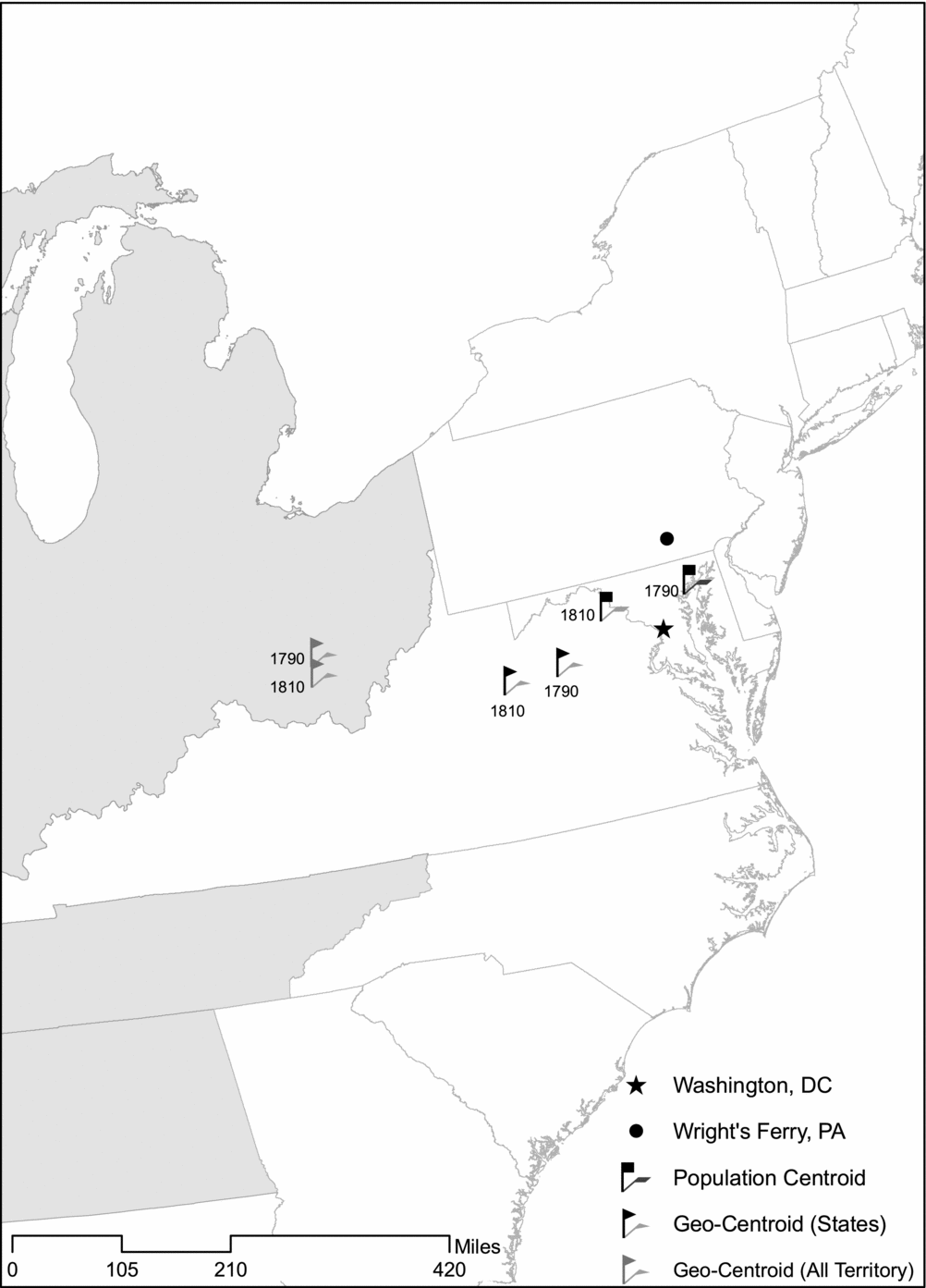
Our expectation based on Madison's representative theory is that the capital should be located near the population and geographic centers of the country where those two points are relatively close, which was the case for the new nation. This is indeed what we see, as represented in Figure 1. The map displays the 14 states in the union and the entire territory of the United States as of 1790 and then plots (a) the location of the geographic centroid of both the 14 states and the entire territory of the country as of both 1790 and 1810, (b) the population centroids for the states as of both 1790 and 1810, and (c) the locations of Washington, DC, and Wright's Ferry.
Mapping Washington, DC

In keeping with our expectations, Washington, DC, was extremely close to both the population and geographic centers at the time it was chosen as the nation's capital: a mere 56 miles from the population center and 95 miles from the geographic center of the 14 states in the union at that time. By comparison, Wright's Ferry was slightly closer to the population center in 1790, 48 miles, but somewhat farther from the geographic center, 148 miles. In short, either Washington, DC, or Wright's Ferry would have been good choices for the capital as of 1790. However, as we have seen, the representatives who debated the issue were aware that the population of the country was shifting westward and would definitely continue to do so as new states entered the union. In other words, there is ample reason to suspect that the representatives anticipated where the future population center of the nation would be. In this regard it appears they were quite foresighted: in 1810, Washington, DC, was a mere 50 miles from the population center of the 17 states in the union by that point, with the population center now lying to the west instead of the east of the capital, putting Wright's Ferry at 81 miles from the population center and growing inexorably more distant.Footnote 5 Finally, these results are also consistent with the hypothesis that representatives weighed population centrality more heavily. Washington, DC, was closer to the population center than the geographic center in both 1790 and 1810. This outcome is even starker if we consider that the geographic center of the entire territory of the United States (i.e., states plus territories) was even farther to the west than the geographic center of just the states in the union.
In sum, in choosing Washington, DC, as the nation's capital Madison and his fellow representatives achieved an outcome consistent with representative principles. Their choice of the permanent seat of government was very close to the population and geographic centers of the new nation—indeed, it was remarkably close, especially given that the entire extent of the 14 states in 1790 was about 667,000 square miles (and 1,315,000 square miles if one also counts the western territory). We now turn to the location and relocation of state capitals to determine whether the decisions in the states, where the political forces uniquely at issue in the choice of the nation's capital were not at work, followed the same pattern as the choice of the site of Washington, DC.
THE LOCATION AND RELOCATION OF STATE CAPITALS
The choice of where to locate the nation's capital faced by the representatives in the First Congress was hardly unique. As noted earlier, to illustrate his theory of how the principles of representative government should guide the debate over the site of the federal capital, Madison pointed to movements in various states to relocate their capitals from the colonial seat of government. Fully 11 of the original 13 states chose to relocate their capitals within the first few decades after independence. Thus, if Boston comes to mind as an example, almost distastefully European in flavor, of a case where the state capital remained located at the traditional center of power, it is remarkable that it is more of an exception than a rule. When new states entered the union they too faced the issue of where to locate their capitals. Most followed the lead of the 11 original capital removals by choosing to locate their capitals not in urban centers (such as they were at the time), like St. Louis, Chicago, or New Orleans, but in places such as Albany, Jefferson City, Springfield, and Baton Rouge that were closer to the geographic and especially population centers of their states. Indeed, according to Campante and Do (Reference Campante and Do2010), whereas the majority of capitals in the world are located precisely at the point of the greatest concentration of population of the state, capitals in the United States, with just a few notable exceptions such as Rhode Island and Hawaii, currently lie in areas with very low population concentrations. Indeed, they note that Springfield, Illinois, is located at the lowest population concentration level of any political capital in the world. Finally, a surprising number of states ultimately decided to relocate their capitals, often more than once.
In our discussion of the choice of Washington, DC, as the nation's capital, we cited the debates in the First Congress to show that the representatives were thinking in terms of the principles of representation that were articulated most forcefully by Madison. We found similar evidence for this line of thinking in an examination of decisions regarding where to locate or relocate capitals at the state level. For example, when discussing the removal of the capital of Virginia from Williamsburg to Richmond, Maier (Reference Maier2010, 255) writes, “It had become Virginia's capital in 1779 . . . when the old capital, Williamsburg, seemed too close to the sea and vulnerable to naval attacks, and the surging population in interior parts of Virginia argued for moving the state's government to a more central location.” However, because legislative debates over capital location are largely nonexistent and evidence from other sources is difficult to assess in a systematic manner, we restricted ourselves to an empirical analysis of whether the placement of state capitals was consistent with the predictions of the theory of capitals as representative institutions.
Data and Methods
We gathered information from historical sources on the location and relocation of capitals in the 48 contiguous states from 1776 until 1910, the date of the last decision in this regard. We did not include Alaska or Hawaii in our examination for two reasons: both states pose special geographical issues with regard to choice of capital, with Alaska being sparsely inhabited and Hawaii being a chain of islands, and both have population patterns that would positively bias our analysis.Footnote 6 The 48 states had a total of 95 capitals to analyze, including 47 instances where a capital was relocated. Our universe of capitals did not include cases where the seat of government was temporarily relocated due to war; that is, during the Revolutionary and Civil Wars. We also did not include Rhode Island because its capital rotated among towns until Providence was chosen as the permanent capital in 1901. We similarly did not count the decision in 1790 to locate the capital of New Jersey in Trenton as an instance of relocation because the capital had earlier rotated between Perth Amboy (in the northeast of the state) and Burlington (in the southwest of the state), making it impossible to determine a single location from which the capital moved. For cases when a state became independent (as with the 13 original states, but also with Texas and California) or when a new state was formed from a territory, we considered as an instance of an initial state capital those cases where the physical boundaries of the territory were the same as the boundaries of the state and where the initial capital was in place at least temporarily before a permanent capital was chosen. For example, we counted Omaha as the initial capital of Nebraska, even though Lincoln was almost immediately chosen as the new capital after statehood, and we therefore considered Lincoln as a case of capital relocation. None of these classification decisions affected our results. A full list of capitals, including the codes we use to identify them in our figures, can be found in the Appendix.
As with our analysis of the choice of Washington, DC, as the nation's capital, our data came from historical census and political boundary data retrieved from the National Historic GIS (NHGIS). As previously, we calculated the geographic centroid as the simple geometric center point of a state; we calculated the population centroid of a state by weighting the geographic centroid of each county by its population and then determining the weighted mean point of the populations of all of the counties in the state. To determine the population for any given year in which a decision is made (or 20 years later in our forecasted model), we interpolated data from the two closest decennial censuses and used 1790 data for cases prior to the first census.
In comparing how close a capital is to the geographic and population center across states and across time within a state where geographical borders changed (e.g., Virginia contained the territory that is now West Virginia until the Civil War), we required a method that produces a comparable measurement of the relevant distances across states of very different sizes and shapes.Footnote 7 For example, a distance of 100 miles from the capital of New Hampshire to its population center has a very different substantive meaning than the same distance from point to point in Texas. We therefore needed a method that would take absolute distances and convert them into relative distances comparable across states. To overcome this methodological hurdle, we were inspired by the frequent use in the early republic of the image of the capital as the center of a circle of influence and affection. For example, Thomas Paine ([1791] Reference Paine1995, 233), rejecting the traditional image of the state as a body with the king as its head, explained that a nation is “like the body contained within a circle, having a common centre, in which every radius meets; and that centre is formed by representation. This cannot be accomplished by any method so conducive to the various interests of the community, as by the representative system.”
With this image in mind, we adopted a three-step approach to standardize distances across states. First, we reconstructed each state as a circle with an area equal to the area of the state itself, with the geographic centroid at the circle's center. Second, we determined the radius of this circle. Finally, we measured the distance among all the points of interest within each territorial entity of interest—the geographic centroid, the population centroid, and the location of the capital—in circle radiuses.Footnote 8 This approach gave us an easily comparable measure that was consistent across all states.
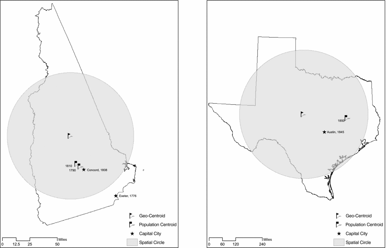
We illustrate our method in Figure 2, which shows how our transformation of the distances within each state into circle radiuses occurs in the two states used earlier as an example: New Hampshire and Texas. First, we drew the actual boundaries of the two states and marked the capital, population center, and geographic center of each state. Second, we superimposed a representation of the geographic size of each state in terms of a circle centered on the geographic centroid. In the case of New Hampshire, there were both an original capital and a relocated capital. The former capital city of Exeter was 67 miles or 1.26 circle radiuses from the geographic center and 44 miles or .48 radius from the population center of the state in 1790, whereas the relocated capital of Concord was 32 miles or .60 radius from the geographic center and 10 miles or .20 radius from the population center. In Texas, the capital of Austin was 122 miles from the geographic center and 115 miles from the population center of the state at the time of the first available census information (1860), which equates to .42 radius from the geographic center and .40 radius from the population center. Finally, for comparison's sake consider the example of Washington, DC. In 1790 the city was 55 miles or .15 radius from the population center.Footnote 9
Example of Transforming Distances within States into Circle Radiuses

Finally, we note that our method of locating capitals and measuring distances within any given territorial entity, whether the United States as a whole or the individual states, ignores the topographical features of these territorial entities, such as rivers or mountains, which might positively or negatively influence decisions where to locate capitals. If anything, then, our results concerning the location of capitals using topographically neutral data are less precise (and thus negatively biased) than if we had also taken into consideration these geographical factors.
Results
The Location of All Capitals
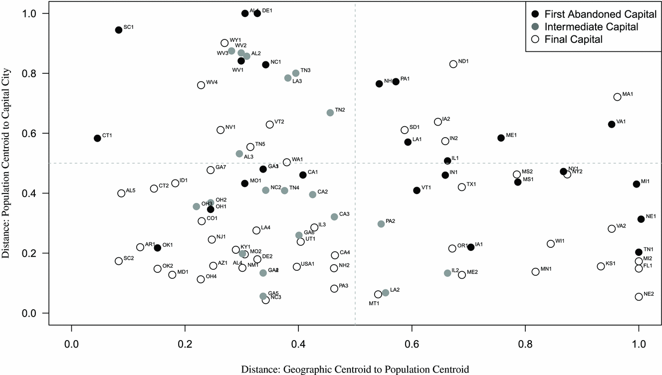
Figure 3 displays the results for the placement of all state capitals. Recall that for both capital locations in general and the decisions to relocate capitals in particular, we hypothesized that (1) when the population and geographic centers are relatively close together, the capital will be placed near both and that (2) when the population and geographic centers are relatively distant, the capital will be placed closer to the population center. The two axes of the figure represent the underlying logic of these hypotheses. First, the x-axis represents the distance in circle radiuses between the geographic and population centers of the states. Thus, the farther out one goes on the x-axis, the more distance there is between the geographic and population centers of a state at the relevant point in time, making it easier to determine which “target” decision makers aimed at in locating their capital. Second, the y-axis represents the distance in circle radiuses of the capital from the population center of the state. Thus, the closer one is to 0 on the y-axis, the closer the capital is to the population center. We included cut-lines at the .5 radius points for each axis for ease of interpretation. The location of each capital is plotted in this space as circles using population data from the time when the decision to locate (or relocate) the capital was made. The circles are either shaded or hollow, with dark shaded circles representing original capitals of states that were “abandoned” when the capital was relocated (e.g., Exeter, New Hampshire), lightly shaded capitals representing capitals that were neither the original capital nor the final capital (e.g., Benicia, California), and hollow circles representing either capitals that were never relocated (e.g., Boston, Massachusetts) or “destination” capitals (e.g., Atlanta, Georgia).
The Location of State Capitals

In Figure 3 we see overall that most of the capitals are on average placed relatively near population centroids, as indicated by the fact that most are located in the lower half of the figure. The capitals plotted in the figure were on average .42 radius away from the population centroid, whereas they were .61 radius away from the geographic centroid. The difference between these two values is statistically significant, thereby suggesting that decision makers targeted population centers rather than geographic centers in locating capitals.
Turning to our hypotheses regarding the placement of the capital when the geographic and population centers are relatively close together, we see that most capitals are located close to both the geographic and population centers; that is, in the lower left part of Figure 3. In these cases it is not clear which target, the geographic or population center, might have been privileged by the decision makers, especially because the relative distances in such cases are typically small and thus substantively uninteresting, but we get a better idea of their intentions when we turn to capital relocation. Analysis of cases where the geographic and population centers are relatively far apart, however, suggests that decision makers were trying to minimize distance to the population center. These cases are found in the right-hand side of Figure 3: In most of these cases the capital is located closer to the x-axis; that is, in the lower right quadrant of the figure as opposed to the upper right quadrant. Note that these results hold even though this analysis includes all capitals, including “eccentrically” located capitals (to use Madison's language) such as Exeter, New Hampshire. These abandoned capitals (represented as dark circles) tend to be in the upper part of the figure, meaning that they were indeed eccentrically located. Footnote 10
Capital Relocation
We turn now to the question of capital relocation, first using population data contemporaneous to the decision to relocate a capital and then using a 20-year forecasted model.
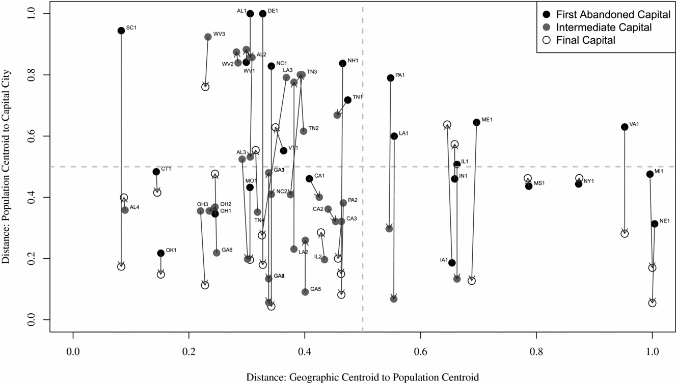
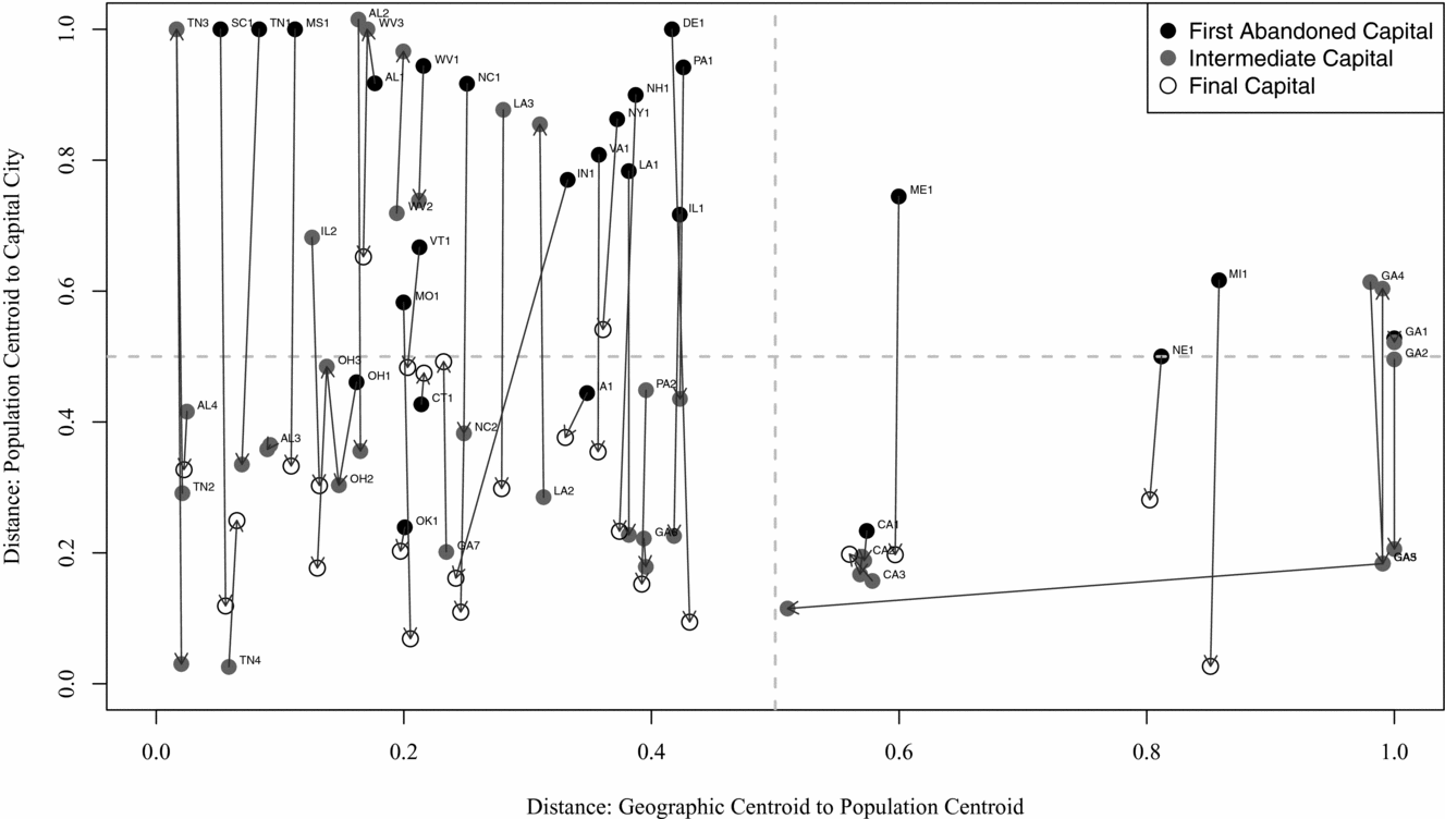
Figure 4 displays the results for decisions to relocate capitals using contemporaneous population data. This figure is arranged in precisely the same way as Figure 3, with the difference that we indicate each decision to relocate a capital by plotting the “abandoned” capital and the “new” capital and drawing an arrow between them. These “abandoned” capitals are represented as a dark circle in cases where it was the original capital, a lightly shaded capital for intermediate capitals, and a hollow circle if the capital became a state's final capital. We label only the capital being abandoned (thus “abandoned” as well as intermediate capitals) to make the figure more legible.
Relocation of State Capitals

If the results for capital location in general support our hypotheses, the results for capital relocation strongly support them. In terms of Figure 4, overall we expect movements to be downward—toward the population center—and indeed this is what we observe. Decisions to relocate capitals moved the capital on average .15 radius closer to the population center than their previous locations. Although they were also moved an average of .32 radius closer to the geographic center on average, the final capitals ended up much closer to the population than the geographic center. Confining the analysis solely to final capitals (represented by the hollow circles), these cities were on average .32 radius away from the population center yet .47 radius away from the geographic center. This difference is again statistically significant.
Turning to our hypothesis regarding the placement of the capital when the geographic and population centers are relatively close together, we see that in that situation (that is, in the left-hand side of Figure 4), the vast majority of capitals were relocated even closer to the population center. This confirms our first hypothesis, and it also suggests that the “real target” in the relocation was the population center. Second, when the population and geographic centers were relatively distant from one another (that is, in the right-hand side of Figure 4), the vast majority of the capitals were located closer to the population center, confirming our second hypothesis. The few notable exceptions to this pattern tend to be exceptions that prove the rule. Notably, in Louisiana the capital was moved from Baton Rouge to New Orleans in 1865, representing an increase in distance from the population center, but the capital was then subsequently moved back to Baton Rouge in 1880.Footnote 11
Finally, we note that the relocation of colonial capitals offers a small-scale natural experiment concerning institutional change. As noted earlier, the newly independent states reformed the representative institutions they inherited from their colonial past, and one of the reforms made by 11 of the original 13 states was to relocate their capitals. For the nine cases of relocation we can examine,Footnote 12 the original capitals were a full .79 radius away from the population center, so indeed “eccentrically” located. Similarly, the decisions to relocate the capital produced among the largest changes we observed among capital relocations, with an average of .44 radius of movement closer to the population center of the state. These cases suggest that the change in representative institutions during the early republic produced dramatic changes in capital location because capitals were themselves reconceived of as representative institutions.
Turning to the analysis of capital relocation using 20-year forecasted population data, shown in Figure 5, we not only confirm the results of our analysis using contemporaneous data but we also see that decision makers were quite foresighted regarding population trends in deciding where to relocate their capitals. Their increased accuracy can be seen by comparing the results using forecasted data in Figure 5 to the contemporaneous data displayed in Figure 4. The locations of the “destination” capitals were even closer to the population centers 20 years in the future than they were at the time of the decision, and moreover the capitals that decision makers were abandoning in fact grew even more distant from the future population center of their states. Relocated capitals using this forecasted population data were on average .25 radius closer to the population center than their previous location. Although they were also moved .24 radius closer to the geographic center on average, “destination” capitals ended up much closer to the population center than the geographic center. Confining the analysis to “final” capitals (represented by the hollow circles), these cities were on average .28 radius away from the population center yet .43 radius away from the geographic center. Both differences are statistically significant.4
Relocation of State Capitals (Using 20-Year Forecasted Population Data)

Although the results strongly suggest that decision makers anticipated future population movements, we must consider the possibility that the relocation of the capital itself resulted in increased population centered near the seat of government, which would prove not that the decision makers showed foresight about population trends but rather that population is endogenous to capital location. To address this concern we analyzed population growth during the 20 years in question, comparing population growth of the county in which a capital was located to population growth for the state as a whole. The results of this analysis showed that population did not grow at a statistically significantly higher rate in the area around the capital as compared to the state as a whole. (As mentioned earlier, the same is true for the population growth of Washington, DC, in comparison to the country as a whole.)
In sum, our analysis of capital relocation is highly consistent with the hypotheses derived from a theory of capitals as representative institutions. Where the population and geographic centers of the state were relatively close, decision makers tended to relocate the capital near both of these centers, in keeping with our first hypothesis, although we have also seen evidence that suggests that the population center was their actual “target.” Where the population and geographic centers were relatively distant from one another, they privileged population centrality in their decisions.
Capitals That Were Not Relocated (But Should Have Been)
We conclude by addressing the question of whether and when state capitals did not move when they should have done so as they became more “eccentrically” located. Of course, the removal of a capital is not a costless endeavor, so we would expect there to be a great deal of inertia in this regard, especially as a capital becomes established over a long period of time. In addition, changes in transportation and communication technology have significantly reduced the time and expense incurred by representatives and citizens in reaching their seat of government, which would again make the location of the capital a less significant issue over time. However, for the present purposes we assumed that capital location is entirely costless and ask how many cases there are where a state capital “should” have been moved. We addressed this question by using as our threshold standard what we empirically saw with actual state capital relocation. Specifically, we adopted as our threshold the mean value plus one standard deviation of the observed change in distance from the population center to the abandoned and new capital (.53 + .30 = .83 circle radius). Finally, we used decennial census data to determine when a capital crossed this threshold standard of being mislocated.
Remarkably, only three states “should” definitely have moved their capitals by these criteria: California, Florida, and Wyoming.Footnote 13 As for Wyoming, its capital of Cheyenne has always been “eccentrically” located. The fact that the city is located on the transcontinental railroad and was usually the most populous city in the state arguably makes its location a sensible one for the state capital, especially because Wyoming's low density of population (second only to Alaska) makes the issue of capital location a thorny one. According to our standard, Florida should have relocated its capital as of 1920, and California should have relocated its capital as of 1930. The case of California is particularly interesting. Sacramento only crossed our threshold of being mislocated in the decades immediately following the construction of the first aqueducts that brought water to the Los Angeles area, thus making that part of the state habitable by large populations and triggering a massive growth in population. In sum, one reason that the vast majority of states do not continue to relocate their seat of government is that their capitals continue to be “correctly” located.
CONCLUSION
In this article we have shown that decisions to locate capitals in the United States were consistent with Madisonian conceptions of representation as maximizing individual access to the seat of government, both for the national and state capitals. In particular, our empirical analysis revealed that capitals in the United States were consistently chosen to be near the population centroids of the relevant territory. In this regard, the choice of Washington, DC, as the nation's capital follows the same systematic pattern as we see in the states. In those cases when capitals ended up in “eccentric” locations they were almost always moved to more centrally located sites. Moreover, our results indicate that the vast majority of state capitals continue to be close to the population centers of states.
Our conclusions have implications both for the study of American political development and more broadly for the study of institutional design. For American political development, it has long been argued that early American politics constituted a break from traditional notions of representation. Notable was a gradual shift from the virtual representation of places to the popular representation of individuals (Wood Reference Wood1969; Zagarri Reference Zagarri1987). As part of this transformation, state constitutions were rewritten, suffrage rules gradually expanded (Keyssar Reference Keyssar2000), and legislative apportionment was increasingly founded on the basis of population rather than places (Kromkowski Reference Kromkowski2002; Rehfeld Reference Rehfeld2005; Zagarri Reference Zagarri1987). Our study demonstrates that decisions to locate and relocate capitals were a critical, but underappreciated, element of this revolution. In light of these findings, it would be instructive to analyze the impact of variation in geographic distance to the capital, across jurisdictions and across time, on the outputs of the state and national governments. Similarly, one could examine how changes in travel and communication technologies over time altered the ability of citizens to monitor representatives.
The results presented here also suggest that studying capital locations in other countries might open a new window into understanding the design and development of representative political systems. Whereas European capitals were located at traditional centers of power that pre-dated the appearance of representative democracy and capitals in autocratic countries were typically chosen by decree, in the case of the United States, capitals appear to have been chosen with representative principles in mind. It would be instructive to examine the extent to which this finding holds in other modern representative systems. Indeed, the locations of capitals in other representative democracies strongly hint that dynamics similar to those found in the United States may have been at work. In Australia, for instance, Canberra was chosen as the permanent capital in 1908 after the creation of the Australian federation. Given that Canberra was, and continues to be, roughly equidistant between the two major population centers of Australia—Melbourne and Sydney—yet quite distant from the geographic center of the country, there is reason to suspect that conceptions of maximizing popular representation may have been at work (Hugo and Harris Reference Hugo and Harris2011). In Canada, even though the initial decision to place the capital at Ottawa was made by Queen Victoria, Ottawa to this day remains close to the population centroid of the country (Kumler and Goodchild Reference Kumler, Goodchild and Janelle1992). That such patterns might be found in other countries suggests an intriguing new line of inquiry into the emergence and growth of representative democracy.
State Capitals





Comments
No Comments have been published for this article.