Introduction
[I]n the winter [the sea ice] is very useful. We rely on it, that's why we have to know the conditions so much because we [use] it from beginning to the end. It was so much so in the past, but not as much now. We don't rely as much on country food, like it's only a percentage now of our daily diet. [B]ut still we use that information. [It] is good for as long as we live here because we're still going to use [the ice]. I don't see any highways out on the land, so it's still going to be our highway. The kids still have to learn the points, the fall and the spring and the winter, the conditions, they will have to learn that. [A] big part of our life is spent on the ice, especially here where our name is, where our regional name is so much recognizable as people who live ‘where there's water’, not just ice, but where there's water. It's very important to know [about the sea ice] (Joanasie Reference Joanasie2004).
Sea ice is an important platform upon which Inuit have been travelling, hunting, gathering, and living for at least 5000 years (Riewe Reference Riewe1991). While many Inuit are now settled in coastal communities, sea ice continues to form an integral social, economic, and traditional component of their lives (Wenzel Reference Wenzel1991; Pelly Reference Pelly2001; Poirier and Brooke Reference Poirier and Brooke2000; Aporta Reference Aporta2004; Robards and Alessa Reference Robards and Alessa2004). The knowledge they have developed of the ice, its nature, and its processes is embedded within their culture and identity (Aporta Reference Aporta2002). Inuit are astute observers of the sea ice edge (Nakashima Reference Nakashima and Inglis1993) as their harvesting practices, livelihoods, and/or personal safety depend on their knowledge and perception of changing ice, sea, and weather conditions. As such, Inuit elders and active hunters may be considered the experts on local ice conditions and dynamic processes because of their extensive use and experience of traveling on, and observing, ice conditions in order to assure safe travel and successful hunting (Nelson Reference Nelson1969; Freeman Reference Freeman, Cooke and van Alstine1984; Krupnik Reference Krupnik, Krupnik and Jolly2002). As climate change is now at the forefront of public and scientific consciousness, the implications of changing sea ice environments on northern communities and wildlife are often at the centre of current research and debates (Kerr Reference Kerr1999; Copley Reference Copley2000; IPCC 2007; Symon and others Reference Symon, Arris and Heal2005). However, relatively little has been done to document systematically, or to understand, Inuit knowledge of these environments in efforts to learn about potential implications from local perspectives (Thorpe and others Reference Thorpe, Riedlinger and Fox2000; NCE Reference Tremblay, Furgal, Lafortune, Larrivée, Savard, Barrett, Annanack, Enish, Tookalook and Etidloie2000; NRI Reference Wang, Mysak and Ingram2002). Yet this is an important foundation for discussions around adaptation and vulnerability/resilience.
Within the scientific community, there is a limited understanding of sea ice at local scales, especially in relation to Inuit culture, lifestyle, and socio-economic practices. This paper is the first in a series of three coordinated by the first author, and with different other authors, that presents an initial attempt to document and communicate sea ice conditions and Inuktitut (Inuit language) terminology based on detailed local expertise in different Inuit communities around Baffin Island, Nunavut. Here, we present the results of research undertaken in Cape Dorset, Nunavut, from April 2004 to May 2005. Documenting Inuktitut terminology and explanations of local freeze-thaw processes, and the related influences of winds and currents on ice formation or movement, provides a unique glimpse of Inuit expertise on local-scale physical ice conditions and processes. Such detailed Inuit understanding has been documented previously in Alaska through Nelson's (1969) in-depth account of sea ice conditions and use around Wainwright, the important volume of Oozeva and others (Reference Oozeva, Noongwook, Noongwook, Alowa and Krupnik2004) depicting local ice conditions and Yupik terminology for Savoonga and Gambell, and the description of Barrow ice conditions by Gearhead and others (2006). Freeman (Reference Freeman, Cooke and van Alstine1984), McDonald and others (Reference McDonald, Arragutainaq and Novalinga1997), Aporta (Reference Aporta2002) and Gearheard and others (Reference Gearheard, Matumeak, Angutikjuaq, Maslanik, Huntington, Levitt, Kagak, Tigullaraq and Barry2006) also touch on some key ice conditions and Inuktitut terminology in the eastern Canadian Arctic. The aim of the present paper is to build on these works by providing a detailed account for Cape Dorset, but also to move beyond glossaries by emphasising the interrelations between terminology, ice conditions, and seasonal processes.
Methods
Community
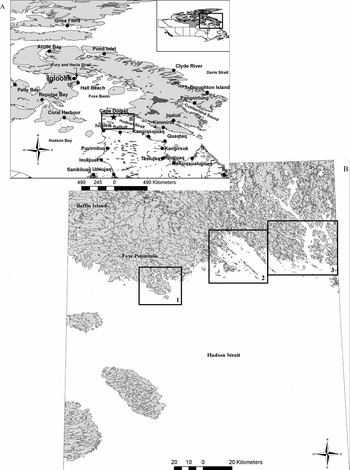
Cape Dorset is located on a small island of the same name off the southwestern tip of Baffin Island (Foxe Peninsula), in Hudson Strait (64°14′N, 76°40′W) (fig. 1a). This area was named by Luke Foxe who explored parts of Hudson Bay and Foxe Basin in 1631, with the cape being named after the Earl of Dorset (Kemp Reference Kemp and Freeman1976). However, in Inuktitut Cape Dorset is known as Kinngait (meaning ‘mountains’) (Milne and others Reference Milne, Ward and Wenzel1995; Laird Reference Laird and Dewar2004). In the past it has also been referred to as Sikusilaaq (meaning ‘where there is no ice’) because of the strong Hudson Strait currents that result in the nearby presence of open water throughout the winter (Walk Reference Walk1999; Henshaw Reference Henshaw2006). The surrounding region has a rich archaeological history, with evidence of Inuit land use and occupancy dating back at least 3000 years (Henshaw Reference Henshaw2006). A Hudson Bay Company (HBC) trading post was established in this area in 1913, which became the basis of community settlement in the 1950s (Kemp Reference Kemp and Freeman1976; Laird Reference Laird and Dewar2004). Now with a population around 1236 (93% Inuit) (StatsCan 2006), Cape Dorset is renowned for its art, cultural history, and proliferation of marine wildlife (Blodgett Reference Blodgett1991; Milne and others Reference Milne, Ward and Wenzel1995; Walk Reference Walk1999; Doubleday and others Reference Doubleday, Mackenzie and Dalby2004).
Study area maps, including: a) map showing the location of Cape Dorset (Nunavut highlighted in grey in inset, and the square indicates the Baffin Island region shown in the larger map); b) map sheets and extent used in interviews, with squares indicating the areas of interest portrayed as subsets throughout the paper (1 = Cape Dorset Island and surroundings (Figs. 7, 9b, 10, and 14b); 2 = Andrew Gordon Bay (Fig. 9a); 3 = Chorkbak Inlet (Fig. 14a)).

Research approach
This project was undertaken with community members of Cape Dorset using a collaborative approach adapted from Gibbs (Reference Gibbs2001), and described in Laidler (Reference Laidler2007), in order to develop cooperatively, and to refine, research directions, questions, plans, and results. This was essential in order to gain community support, involvement, and feedback (ACUNS 2003; Gearheard and Shirley Reference Gearheard and Shirley2007). The research was initiated by a preliminary visit to Cape Dorset in October 2003 in order: i) to propose the project to community groups and organisations; ii) to discuss community interest in the project; iii) to establish jointly research priorities; iv) to answer questions or concerns; v) to assess project feasibility; and, vi) to determine appropriate field work timing and duration. Subsequently, several field research visits were planned according to community suggestions to return at various stages of sea ice freezing and decay (April and November 2004, and January and May 2005), totalling nearly three months spent in the community. A more thorough discussion and evaluation of methods is provided in Laidler (Reference Laidler2007). The main methods relevant to this paper are described here.
Semi-directed interviews
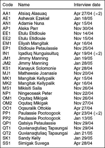
Inuit elders and hunters deemed to be the most knowledgeable about sea ice by community members and representatives (that is community organisations such as the Hunters and Trappers Association, interpreters, and other elders and hunters), were recommended as key informants in a purposeful sampling strategy. In total (over the four research trips), 30 semi-directed interviews (Huntington Reference Huntington1998; Bennett Reference Bennett and Shurmer-Smith2002; Esterberg Reference Esterberg2002) were conducted with 21 different people, 17 male, 4 female (out of a recommended list of 30 people) (Table 1). No fixed questionnaire was administered, and no time limit was placed on discussion (an average duration of which was approximately 2 hours). Instead, general questions about Inuktitut sea ice terminology, descriptions of freeze/thaw processes, and the influences of winds and currents on sea ice formation or movement, were asked in order to initiate discussion and explanation of related topics. All interviews were conducted by the first author, with the second author interpreting or facilitating where the interviewee was most comfortable (or unilingual) in their native language of Inuktitut. Interviews were conducted in people's homes, the Hamlet Council Chamber, and the Malikjuaq Visitor's Centre, depending on what space was available and where the interviewee felt most comfortable. Where consent was provided, interviews were recorded with audio and/or videotape. All originals (and transcripts) are stored at the Community Learning Centre (Nunavut Arctic College) to ensure community access to these materials.
Interview participants (sorted alphabetically by code to facilitate interviewee identification throughout the text).

Four National Topographic Service (NTS) map sheets at the 1:250,000 scale (36B, C, D and 35N; see fig. 1b) were incorporated in interviews: i) to facilitate knowledge-sharing; ii) to enhance explanations of sea ice conditions or uses; iii) to enable spatial delineation of key sea ice features, regional sea ice extent, or uses (for example hunting areas, travel routes); and, iv) to promote discussion or to spark memories (Laidler Reference Laidler2007). Each interviewee had his or her own clear mylar (plastic) overlay upon which he or she could draw sea ice features that were most familiar or that he or she wanted to document.
Sea ice trips
In order to begin to understand, and conceptualise, Inuit expertise of sea ice it was imperative that the authors (and mostly the first author) experience, and participate in, sea ice travel and/or hunting. This is often referred to as participant observation (Kearns Reference Kearns and Hay2000; Fox Reference Fox, Krupnik and Jolly2002), but it is preferred to emphasise the experiential aspects because it was more than simple observation. Such trips were encouraged by elders as being the best way to learn about sea ice from an Inuit perspective, a more traditional method of teaching and learning (Thorpe Reference Thorpe1998). Therefore, these were prioritised wherever possible, and the first author was fortunate to participate in five different sea ice trips (on foot, by dog team, and by snowmobile) to various locations around Cape Dorset (the floe edge, Tellik Inlet, a nearby polynya, and fishing lakes/goose hunting grounds around Andrew Gordon Bay), at least once during each of the research trips. These trips were guided by elders that had been interviewed and a local outfitting/tour company.
Focus groups
Focus groups (Lindsay Reference Lindsay1997; Fox Reference Fox, Krupnik and Jolly2002) were employed to bring small groups of local experts together: i) to link Inuktitut terminology for various ice conditions to pictures taken on sea ice trips; ii) to develop and verify terminology links within a sequential order of sea ice formation/decay based on compiled interviews; and, iii) to verify sea ice features drawn on maps. Two focus groups were conducted in one in each of the third and fourth research trips (January and May 2005). These sessions were an important means of acquiring feedback and helping to ensure the accuracy of the interpretation of results.
Data analysis
Audio recordings were used to compile word-for-word transcripts of the translated (English) components of the interviews. This was followed by content analysis that consisted of coding transcript statements into key themes/topics (Patton Reference Patton1980; Dunn Reference Dunn and Hay2000; Esterberg Reference Esterberg2002). Codes were created to reflect the questions asked in interviews, as well as any new concepts identified through the interview process. Coding was done manually, but was assisted by qualitative analysis software Atlas.ti (version 5.0.66), making it easier to compile similar themes in order to facilitate analysis and the development of conceptual models, explanations of sea ice terminology, and process descriptions. The specific codes relevant to the results and discussion in this paper include: cracks, currents and ice, floe edge, freezing processes, importance of sea ice, Inuktitut terminology, landfast ice, map features, melting processes, moving ice, polynyas, snow influences on sea ice, and winds and sea ice. The conceptual models presented in the following sections attempt to highlight the relationships between each of these ice types/features/processes, based on Inuit expertise, in order to provide an overview of the human geographies of sea ice around Cape Dorset.
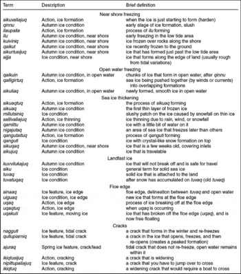
Inuktitut terminology, descriptions, and brief definitions for sea ice conditions associated with freezing stages (in approximate order as shown in Fig. 2).

Knowledge representation
The results presented in the following sections are based on what Inuit elders and hunters shared during interviews, sea ice trips, and focus groups. Because they are the experts regarding local ice conditions, each interview is formally referenced the first time it occurs in the paper. However, for later occurrences, a coding system is used to identify interviewees to save space within the text (Table 1). Square brackets [ ] are employed within quotes to replace third person references used by the second author in interpretation. Every effort has been made to present the information that was provided accurately and consistently to form a comprehensive picture of local ice conditions. Nevertheless, such results cannot be static, and they will evolve as terminology and explanations are refined, new descriptions are added, or formats are changed. It is also important to note that Inuktitut terminology is not standardised across Nunavut, or even within Cape Dorset, so the terms presented here reflect the majority of descriptions provided, but cannot necessarily be extended to other communities within, or outside, Nunavut because of dialectical differences. Furthermore, the authors have incorporated Inuktitut sea ice terminology throughout the text, to the best of their ability, in order to present Inuit expertise in a manner that closely resembles the way in which it was shared with them. Where possible, the scientific sea ice terminology (according to World Meteorological Organization (WMO) standards, as summarised in Laidler (2006a)) has been stated that most closely approximates to the meaning of Inuktitut terms.
Freezing processes
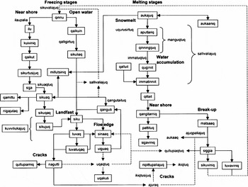
In this section, Table 2 and Fig. 2 should be consulted as references for Inuktitut terminology and links between processes.
Conceptual diagram of freeze-thaw processes, interactions, and terminology based on interviews conducted in Cape Dorset. Where: a solid line = general process direction, a dashed line = cyclical/intermittent process direction. Inuktitut terms in boxes are ice conditions or features, while those outside boxes are sea ice processes. English terms in bold font highlight the general freezing/melting stages.

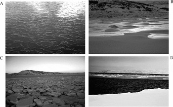
When sea ice begins freezing around Cape Dorset it is referred to as sikuvaliajuq (Nungusuituq 2004 (IN1); Mikigak Reference Mikigak2004a (OM1); Pootoogook Reference Pootoogook2004 (PP1); Petaulassie Reference Petaulassie2004b (QP1) (Fig. 2). The earliest ice formation is qinnu, a slush-like consistency that begins to form with the colder temperatures (likened to frazil or grease ice) (Alasuaq Reference Alasuaq2004 (AA1); Ezekiel Reference Ezekiel2005 (AE1); Joanasie Reference Joanasie2004 (MJ1); Ottokie Reference Ottokie2004 (OO1); Kelly Reference Kelly2005 (SK1)) (fig. 3a). However, as freezing progresses, different terms are used concerning whether the ice is extending from the shoreline or forming in open water.
Photos of early near-shore freezing, including: a) qinnu, early slush-like ice formations; b) kuiviniq, ice freezing to the rocks; c) early formation of sijja, shoreline ice; and, d) sikuliaq, new ice forming in open water.

Near-shore freezing
Along the shoreline, the process of ilaupalia (OM1) contributes to the formation of ilu, where ice has frozen to the ground when the tide was low (Parr Reference Parr2004 (AP1); Etidlouie Reference Etidlouie2005a (EE1); Kellypalik Reference Kellypalik2004a (MK1); Saila Reference Saila2004 (MS1); OM1; QP1; Tapaungai Reference Tapaungai2004 (QT1)).
[The] beginning stage of freezing up, that is when it's low tide, rocks or the sand will start freezing when it's low tide and it starts to be cold. But [when] high tide comes that ice will float up from the frozen part, and then it will keep freezing until then, unless it's windy. [W]hen it starts freezing, ilaupalia, is the first stage. Sometimes [there] will be chunks forming where it's freezing, that's kind of where it's shallow, you will see [ice] that has formed where there was a rock right under it, but actually the rock is like 4 feet down under there (Mikigak Reference Mikigak2004a).
Ice then begins to freeze to the rocks in shallow areas (kuiviniq), but it will break off when the tide is high (Petaulassie Reference Petaulassie2004a (EP1)) (fig. 3b). This ice eventually freezes to the ground (qaikut), but it will pop up after several tides (AP1; Peter Reference Peter2004 (NP1); QT1). Following this, as the ice extends past the low tide area it is referred to as sikurtusijuq (QT1). Once the shoreline ice has formed fully, and is attached to the land, it is known as sijja (Nuna Reference Nuna2004 (AN1); EE1; MK1; QT1) (fig. 3c). From the sijja, ice extends outwards from the land as it freezes, thus coming together with other ice conditions that have formed in open water (Fig. 2).
Open water freezing
Away from shore, after qinnu has formed, there are different terms used to describe sea ice freezing (Fig. 2). Chunks of ice that form because of movements in open water are referred to as qaikuin, which may also be found along the floe edge (see below) after it has been established.
[Q]aikuin the next stage after qinnu, that's when chunks of ice will form on top of the slushy water. After that stage it will [stay] like that for a few days until it either gets colder or warmer. Qaikuin is the word that's used when the ice is still kind of wavy (Ezekiel Reference Ezekiel2005).
These qaikuin are usually created during windy conditions, where waves push the qinnu together into distinct ‘chunks’, thus forming patches of rough, free-floating ice that move with the currents (likened to pancake ice) (AE1; Mikigak Reference Mikigak2004b (OM2); SK1). Similarly, when ice is freezing in open water, especially with the influence of winds or currents moving it around, ice tends to thicken as it is pushed together with, or onto, other pieces of ice. This process is referred to as qalligirtuq (EE1). Following this, newly formed, relatively flat ice that freezes in open water is called sikuliaq (likened to ice rind) (AE1; AN1; IN1; QT1) (fig. 3d). From there, early ice formations in open water tend to begin joining up with ice formations that have extended from the shoreline (Figs. 2, 4).
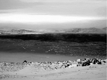
The freezing process, gradually extending away from shore, 23 November 2004, Cape Dorset.

Sea ice thickening
[The] first layer of freezing ice is called sikuaq. Also, depending on the ice thickness you can say sikuaqtuq or sikuaq depending on what sentences you use or what subjects you use on the ice. [The] first night when it freezes it's usually very shiny, after one night it could be maybe a 1/4 inch thick or so (Alasuaq Reference Alasuaq2004).
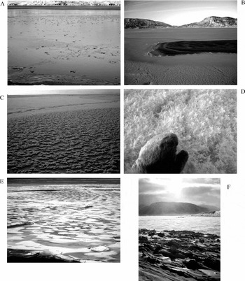
The first continuous layer of frozen ice is sikuaq (likened to nilas or young grey/white ice), whereby sikuaqtuq is the process of sikuaq forming (AA1; MJ1; Suvega Reference Suvega2004 (SS1)) (fig. 5a). Because sikuaq can refer to a range of thicknesses of newly frozen ice, it may be possible to walk on sikuaq, but a person must carefully test it with a harpoon to determine its strength and thickness.
In terms of freezing up, sikuaq is very thin, you can puncture a hole [with a harpoon] in one or two strokes into the same spot . . . Usually [by the] second day if it's the same coldness or colder when it was freezing, you can go on it, but you have to [travel] with a harpoon . . . [I]f you strike the same spot twice and it goes through that's too dangerous, once very dangerous (Joanasie Reference Joanasie2004).
Photos of sea ice thickening, including: a) sikuaq, thin, newly formed ice (note that although sikuaq is described as thin, it is also sometimes described as being capable of supporting a person's weight; therefore, sikuaq can be within a range of thin ice conditions, not necessarily only the thin film of ice shown here); b) nigajutaq, an area in the ice that freezes over later than others; c) qanguti forms on thin ice, or at the floe edge, due to the temperature differences between the air and the ocean; d) a closeup view of qanguti, showing the crystal- or snowflake-like formations; e) sikujuq, the ice is thickening and will soon become siku; and, f) tuvaq, solid ice that is attached to land, here tuvaq is shown in Tellik Inlet, and sijja is shown in the foreground.

Because sea ice does not freeze in a completely uniform manner, there can be areas where water remains on top of the ice (qamittu) (MK1) or where certain small patches remain open (nigajutaq) (fig. 5b) (EE2). For either sikuaq or sikuliaq, snowfall on this newly formed thin ice could lead to a thinning of the sea ice (sallivaliajuq) (MS1; QP1). Snow can influence the freezing process in several ways. If the ice is very thin, falling snow will sink into the ice, creating soft ice conditions that may turn into slush (AA1). If the new ice is a little thicker, snow could accumulate on the ice cover, but it then acts as an insulator (uqurusirtuqsimajuq) from the cold air above, allowing the warmer ocean temperatures to melt the ice from below (EP1).
[U]qurusirtuqsimajuq means like when you have a jacket, you know down-filled jackets that have feathers in them? When it has snowed in some areas where ice usually forms, in that area if it isn't that cold and the snow is thickening, the snow won't harden and acts as insulation (Etidlouie Reference Etidlouie2005a).
If this occurs, the ice conditions become very dangerous, and the freezing processes would begin anew (Fig. 2). Furthermore, millutsiniq is a specific condition in which a patch of ice remains mushy after snowfall has accumulated on new, thin ice (Fig. 2) (EE1; EP1; QP1). For example, this could occur if snow had fallen over a crack, where the ice is thinner than either side of the crack. Again, the snow would contribute to the ice melting from underneath, leading to a slushy consistency (EE1; EP1; QP1). An additional condition called qanguti (likened to frost flowers) may form on sikuaq, or on ice at the floe edge (Figs. 2, 5c). The process of qangutaituq leads to the formation of qanguti. This condition is identifiable when the ice is covered with what looks like little crystal-like snowflakes, or flowers growing out of the ice (fig. 5d) (AA1; EE1).
The second part of freezing ice is called qangutaituq. It is called that because sometimes in a few days when the ice is freezing, if it hasn't been snowing or anything, even though it hasn't snowed crystals start growing from the ice. It's like plants are growing on the ice, that's when it starts getting freezing (Alasuaq Reference Alasuaq2004).
The formation of qanguti is also used as an indicator of areas where the ice will form smoothly once it has thickened (AA1; EE1).
As the ice gradually thickens it changes from sikuqaq to sikujuq and finally to siku (Fig. 2). Generally, the ice thickens first in inlets, where it stops moving as it becomes more solid (sikuqaq) (AE1; EE1; EP1; NP1; OM2). At this point seals are making breathing holes (atluan) through the ice, it is a few weeks old, and it is possible to walk on the ice. Then, having thickened past a few inches, sikujuq can be used for seal breathing hole hunting (NP1) and careful travelling (fig. 5e) (EE1; MK1; OO1). Any ice thicker than sikujuq is referred to as siku, a general term for sea ice (likened to first-year ice), which also implies that any kind of sea ice travel is now possible (AE1; AN1; EP1; MJ1; NP1: QT1; SK1; SS1). After siku, tuvaq is used to refer to ice that is older and more solid (thicker) than siku, and is securely attached to the land (likened to landfast ice) (Figs. 2, 5f) (AE1; EP1; MJ1; QT1; SK1).
[S]iku is like loose ice, but tuvaq is land locked ice, it's part of the land. But siku is more loose, could be part of the sea ice if it's broken off, siku. But a lot of people will use siku now [to refer to] tuvaq (Joanasie Reference Joanasie2004).
When the tuvaq thickens and snow accumulates it then becomes tuvatuqaq (old, mid-winter ice) (EP1; NP1). It must be noted that once the ice becomes siku or thicker, snowfall no longer contributes to melting when the temperatures remain cold. Furthermore, ice conditions from sikujuq onwards in the freezing process can be considered kuvvilukajuq (where the ice will not be breaking off anymore) (OM1) (Fig. 2).
Tidal cracks
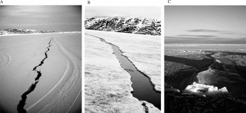
Cracks are usually formed by the movement of the sea ice, from contraction or expansion in the freeze-thaw process, or from the force exerted by winds and/or currents. Tidal cracks tend to form in the same location annually, and go through cycles of cracking, opening, and re-freezing through the winter in synchronisation with the lunar cycle (MS1; NP1; QP1; Tapaungai, Reference Tapaungai2005 (QT2)). They are also affected by the diurnal tidal cycle, where the difference in daily high and low tides causes ice movement and cracking (MK1; SS1). When this kind of crack forms in the winter it is referred to as a nagguti, which means tidal crack but implies that it refreezes after it opens (Fig. 2, 6a) (AA1; AE1; AN1; AP1; EE2; Manning Reference Manning2005a (JM1); MK1; NP1; OM2; QT1; SK1). This same crack in the spring would be called ajuraq because after it opens it does not re-freeze (likened to a lead) (Figs. 2, 6b) (AE1; AN1; AP1; EE2; JM1; NP1; MJ1; MK1; OM2; OO1; PP1; QP1; QT1; SS1; SK1). The term qullupiarniq is also used to refer to a crack that opens, re-freezes, and then opens again in the same spot with a peaked ice formation over the crack (Figs. 2, 8c) (QP1).
Photos of different types of tidal cracks, including: a) nagguti, a tidal crack that forms in tuvaq in the winter and re-freezes; b) ajuraq, occurs in the spring and does not re-freeze after opening; and, c) qullupiarniq, a crack that opens, re-freezes, and opens in the same spot (it can become peaked over where the crack has formed).

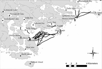
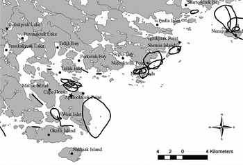
Cracks were frequently drawn on the maps as occurring near Aupaluktuk Point (Apalooktook Point on the map), near Iglukjuak Point, as well as between islands or in narrow areas (Fig. 7).
[P]retty much where there are islands, closer to the islands it will usually form these cracks, except for the mainland area. Usually around the small islands it forms these kinds of cracks. Every little island that you see there's some kind of crack that's going to form (Tapaungai Reference Tapaungai2004).
Key naggutiit (plural for nagguti) in the Cape Dorset area. Sources: AE1; AP1; EE1; JM1; MJ1; OM2; OO1; Pootoogook Reference Pootoogook2005 (PP2); SK1.

Cracks typically form from land to land (usually at points, or between islands) (Fig. 7) (AE1; EE1; EP1; JM1; QT1; SS1), and are thus identified by the nearest placenames on each shore (AP1). Where cracks form by tidal action is also where the ice tends to break off (uqaq or aukaaq) with the influence of winds (EP1; MJ1; MS1; OM2). Essentially, cracks form when stress is placed on the sea ice cover, such as when: i) ice collides or pushes onto, or into, each other; ii) tides or currents move the ice up or down; and/or, iii) winds force the ice together or apart. There can be little cracks all over the ice surface, but naggutiit (plural for nagguti) are both important hunting destinations and potentially dangerous areas where the ice may break off.
Floe edge
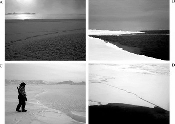
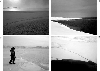
The floe edge (sinaaq) is the edge of landfast ice, the delineation between the tuvaq and open water (Figs. 8a, 8b) (SK1; SS1). At the sinaaq, any new ice that forms is termed uiguaq (literally meaning ‘an addition’), whether it is extending from the edge of the tuvaq or it is re-freezing after ice has broken off (fig. 8c) (AN1; EE1; JM1; MJ1; MK1; NP1). The action of ice breaking off from the sinaaq is termed uqaqtuq (Figure 8d) (JM1; MK1; OO1). Once a piece of breaks off from the sinaaq, it changes from being siku or tuvaq (while it was attached) to being uqakuti (MK1).
[W]e would call that uqaq, uqaqtuq, when a big pan of ice breaks off from a good floe edge. That happens when we have solid ice, and then we have like nagguti or ajuraq, that's when the strong tide comes it'll start to move a bit more, and it's not frozen anymore so it breaks off. We call that uqaqtuq (Manning Reference Manning2005a).
Photographs of the floe edge, and ice formations/dynamics along the floe edge, including: a) the winter floe edge sinaaq is continually in flux, freezing, breaking off, re-freezing, depending on current and wind conditions; b) the spring floe edge (sinaaq) is more defined, as the ice is thicker and it is no longer re-freezing at the edge; c) uiguaq is the new ice that forms at the sinaaq, shown here to the right, where the second author is about to walk; and, d) uqaqtuq is the action of ice breaking off, usually where a nagguti has formed.
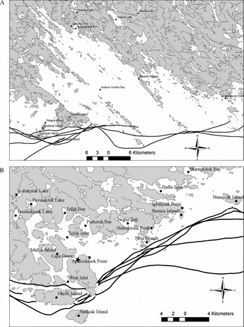
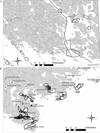
The location of the sinaaq, and experience of it, varies within and between years. So, while the sinaaq positions drawn on the map sheets do vary, they are consistently close to the southern coastline of Baffin Island. Hudson Strait is ice-free, or full of moving ice, throughout the year due to the strong currents moving from Foxe Basin and Hudson Bay into the Atlantic Ocean, or vice versa. Along the eastern map portion the greatest ice extent is found in Andrew Gordon Bay (fig. 9a). On the other hand, nearer to Cape Dorset in the western map portion, the sea ice does not extend far offshore in any area (fig. 9b). However, solid ice does form consistently in Tellik Inlet, and between some of the islands northwest and northeast of Cape Dorset, enabling access to Baffin Island.
Maps showing the approximate location of the sinaaq around: a) Andrew Gordon Bay; and, b) Cape Dorset. Sources: AN1; EE1; EP1; IN1; MJ1; OM2; QT1.

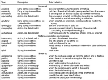
Melting processes
In this section Table 3 and Fig. 2 should be consulted as references for Inuktitut terminology and links between processes.
Inuktitut terminology, descriptions, and brief definitions for sea ice conditions associated with melting stages (in approximate order as shown in Figure 2).

During sea ice decay, conditions can deteriorate unevenly based on a number of factors: current strength, snow cover, water accumulation or drainage, ice thickness, wind direction or strength, air temperature, water depth, etc.
[A]round March time, where there are currents . . . those areas will probably start to get dangerous to travel on. If there are currents in that area, then around March those areas start getting [unsafe] to be travelling on (Saila Reference Saila2004)
An aukaaniq is an area that opens up earlier than others, usually located near areas of stronger currents (Fig. 2) (AE1; EE2; NP1). Around Cape Dorset these tend to concentrate in the areas where polynyas occur. This happens because the ice around polynyas wears out faster than areas in which there is ice cover all winter, due to thinner ice as well as to the strength of currents that wear away the ice (‘wearing’ away of the ice as described by interviewees may be likened to the scientific concept of ablation, related to thermal exchanges, and not necessarily limited to the implied frictional effect). These aukaaniit (plural for aukaaniq) may also be found along the coast where sinaaq dynamics affect ice thickness and stability (Fig. 10).
Key aukaaniit around the Cape Dorset area. These areas wear out earlier than others in the melt process, and can thus be dangerous to travel near or around. Sources: EE1; JM1; Kellypalik Reference Kellypalik2004b (MK2); MJ1; MS1; QT1.

Snowmelt
[T]his time of year [April], thinning of the ice usually starts from the bottom, and also this time of year it's where there are usually currents . . . that are not safe to be travelling on anymore. And our inlet areas will be safe until the ice actually gets out of the inlet (Alasuaq Reference Alasuaq2004).
Because ice thinning begins underneath the snow cover, it cannot necessarily be detected visually, so early melt stages are assessed based on snowmelt and snow conditions on top of the ice (Fig. 2).
[W]hen [I] check to see if the ice is melting, [I] will go on the ice if [I] can't tell from looking at it. [I] will get a handful [of snow], if it makes a snowball, if it sticks together, [I] know it's melting now. But if [I] do that and it doesn't stick, it just crumbles off, [I] know it's not melting then (Alasuaq Reference Alasuaq2004).
The earliest melt stage is identified as aukajuq (AA1; JM1; MK1; OO1). Snowfall around April and May begins to contribute to ice melting (aputlariq) (Etidlouie Reference Etidlouie2005b (EE2); MS1). The snow starts to become soft and wet, but if the ice underneath is still solid it is termed qinningijuq (EE2). The process of manguqtuq is a general descriptor for the onset of ice melt, beginning with snowmelt and then influencing the ice underneath, and thus comprises both aputlariq and qinningijuq (AA1; PP2; QP1). The process of sallivaliajuq also extends over several melt stages, generally referring to when the ice is thinning due to influences of the snow, rain, or wind (Fig. 2). In the spring this stage also refers to a period where the seals are having their pups (around April or May) (MS1; QP1).
Water accumulation and drainage
Once the snowmelt is underway, water begins to form on top of the sea ice, a process called immaqtuqtuq (QT1).
[I ]mmatuqtuq mean[s] water is starting to form on top of the ice, that's one of the beginning stages of melting ice. And then immatinniq is where water is staying on there, [until] the end of the month or something, until it starts draining down. And then [you can also] say tasiaruq meaning pretty much the same thing as immatinniq (Tapaungai Reference Tapaungai2004).
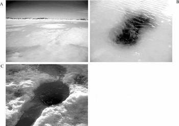
This leads to melt rivers (quginiit) (AA1; NP1) and melt ponds (immatinniit) (EE2; NP1; QT1) forming before there is sufficient drainage to decrease the water accumulation (Fig. 2, 11a). These immatinniit can also be caused by qalluit, holes formed in the ice by seaweed (or other debris) that has melted downwards (such debris absorbs more heat than the ice surface, thus forming melt puddles around it) (fig. 11b) (EE2; OM2). Finally, water begins draining through qillait (likened to thaw holes) once the ice has melted all the way through in areas (Fig. 2, 11c) (EE2). Drainage (matsaaq) (EP1) also occurs through atluan and ajurait (fig. 6b). After substantial water drainage has occurred, the ice actually pops up from where it was frozen to the ground, becoming free-floating but remaining a large, intact, continuous ice surface (qangitarniq) (Fig. 2) (AA1; OM2).
Photos of early melt processes, including: a) immatinniit refers to the accumulation of meltwater on the sea ice, either puddles or substantial water cover; b) qalluit form when seaweed or other material has melted into the ice; c) qillait act as drainage outlets for meltwater.

Break-up
After qangitarniq, pattituq is when there is no longer ice along the tidal zone (Fig. 2) (OM2). The sea ice tends to melt faster along shore, just as it also freezes faster along shore. Once all the shoreline ice (sijja) breaks off, it becomes sijjaviniq when it is floating around (EE2). Away from the shore the ice tends to begin breaking off where the cracks are widest (ajuqpaliajuq) (EE2).
The ice that breaks off first, usually comes almost from the point here, there's a point just over here where it breaks off first [referring to the map]. And then next point up it will form a crack where the other point is, and then next point it will break off, and then a big chunk usually comes off all at once (Petaulassie Reference Petaulassie2004a).
Ice breaking off in the spring time, usually caused by winds, is referred to as aukaaq (EP1). When the ice is breaking up (siggia) (MS1; QT1; OO1) qullupiaqtuq may occur (when ice collides and is pushed on top of other ice as it breaks, likened to rafting) (AA1). Finally, once the landfast ice breaks into floating pieces, siku and tuvaq become sikuviniq and tuvaviniq, respectively (Fig. 2) (MJ1).
Cracks/leads
As mentioned previously, an ajuraq is a nagguti that remains open in the spring time (likened to a lead). As the ice deteriorates this kind of crack then widens (ikiqtusijuq, likened to a flaw) to become jumping distance (nipittupaliajuq). As it widens further an open lead forms, requiring a boat to cross the opening (ikiqtuq) (Fig. 2) (OM2).
Wind and current influences on sea ice
Both wind and currents, when they stop at a certain time, like in the fall time, that's when it's time to freeze. [W]hen the wind stops, the water will freeze, and when the current stops, it will freeze (Kellypalik Reference Kellypalik2004a).
Mentioned briefly throughout earlier sections, winds and currents greatly influence how and when ice forms, moves, or deteriorates. For both winds and currents, the general conditions around Cape Dorset are described, followed by a characterisation of their influence on sea ice.
Prevailing winds
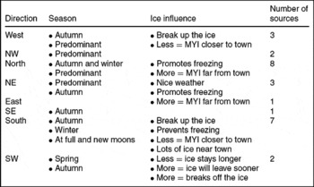
There is little consensus on a predominant wind direction around Cape Dorset, and the related sea ice conditions (Table 4). The predominant wind direction was identified as being somewhere between west and northeast, with northerly winds being the most commonly cited as prevailing (Table 4). In contrast, southerly and southwesterly winds were most often mentioned as being influential on ice conditions, mainly by causing break-off events or keeping moving ice near town (Table 4). There are a few possible explanations for this variation:
a) the interviewee, or the interpreter, was unclear about which direction they were referring to (for example mixed up the directions, or said one and meant another);
b) wind directions are not easily translated into English, which can lead to confusion or misinterpretation after translation (for example northwest is the most commonly cited predominant wind, but in popular media, the Inuktitut term for northwest is often translated into English as north (T. Ikummaq, personal communication, 2005));
c) the wind directions have noticeably changed in recent years, and respondents did not distinguish ‘usual’ conditions from ‘recent’ conditions.
Summary of predominant directional and seasonal winds around Cape Dorset, and their related influences on sea ice.

Where: MYI = Multi-year ice.
Sources: AA1, AE1, AN1, AP1, EE2, EM1, EP1, KS1, MJ1, MK1, NP1, OO1, PP1, QP1, QT1, SK1.
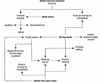
Having stated this, it is not feasible to focus on absolute directions in reporting wind-related results and analysis. However, it is useful to discuss influences of winds on sea ice in relation to the general direction from which they originate. While referring to particular directions, interviewees often mentioned winds coming from the mainland in comparison with winds coming from the open water. Generally, the more northerly winds constitute winds coming from the mainland (that is Baffin Island) and the more southerly winds originate from the open waters of Hudson Strait. So, for the purposes of the remaining discussion, the directions between west and east towards the north are ‘from the mainland’, and the directions between west and east towards the south are ‘from open waters’ (Fig. 12).
Conceptual model of the influences of winds on sea ice formation, movement, or decay based on interviews conducted in Cape Dorset.

Influences of wind on ice conditions or movement
In this section concerning the influences of winds on ice conditions/movement, Table 5 and Fig. 12 should be consulted as references for Inuktitut terminology and links between processes.
When it's time for the ice to freeze, it will usually freeze from the north side, from the mainland side going down. But if it's been windy from the south side for a bit of time, the ice usually won't freeze up for a while. Like [I] said, winds are part of breaking [the] ice (Alasuaq Reference Alasuaq2004).
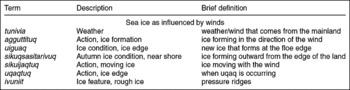
Winds from the mainland tend to bring pleasant (and cold) weather (AA1; PP1), and if sustained within mild to moderate speeds they promote the freezing of sea ice in the autumn (AE1; EP1) (Fig. 12). Therefore, with tunuvia, weather coming from the mainland, the ice will begin to form outward from the edge of the land (sikuqsasitarivuq) (OO1). Winds from the mainland can also drive moving or multi-year ice (MYI) away from the community, allowing for conditions that are more conducive to boat travel (AN1).
Inuktitut terminology, descriptions, and brief definitions for sea ice conditions associated wind influences (in approximate order as shown in Fig. 12).

In contrast, winds coming from the open water are said to have greater influence on ice conditions (SS1), usually in a destructive manner (Fig. 12). In any season, winds coming from the open water are likely to break up the sea ice (uqaq or aukaaq) by causing increased wave action, or by pushing moving ice into the sinaaq (AA1; AE1; AN1; EP1; Solomonie Reference Solomonie2004 (KS1); JM1; MJ1; MK1; MS1). Such turbulence prevents freezing in the autumn (AA1; AE1) and promotes break-up in the spring (AE1). Winds from the open water also bring moving ice close to town, and can keep it there (Mangitak Reference Mangitak2004 (EM1); AN1).
[S]ometimes the ice has broken off from [another] area, it will go right up to around Cape Dorset, and sometimes it will be stuck up [here] for a while. A lot of our hunters will say that there is no floe edge close by because of the ice that has broken off and kind of settled up [here] for either a few days, or weeks at a time (Saila Reference Saila2004).
Light winds, or calm conditions promote ice formation (EM1; EP1; MK1), whereby the term aguttituq describes ice forming in the direction of the wind (Figure 12) (MK1). In contrast, strong winds from any direction can affect ice stability. Ice deformation can be caused when winds push ice on top of other ice, causing it to pile and refreeze into rough ice (ivuniit, likened to pressure ridges) (AA1; AN1).
Another ice is called ivuniit . . . it's like a bulldozer coming from the water side pushing [thick ice] to the islands or the mainland. When it's windy from the south side that happens, or around current areas . . . (Alasuaq Reference Alasuaq2004).
Winds also create wave action, which prevents ice from forming (AP1; MK1), and may cause the sinaaq to open up or break off (KS1; SS1). Seasonally, a windy autumn means that broken pieces of ice will freeze together, rendering spring ice travel dangerous because the ice might break off little by little (Fig. 12) (MJ1). Windy conditions seem more prevalent in the spring (EM1) and they promote ice melting, causing faster ice deterioration than the influence of sun or rain (MJ1). Winds also cause ice movement (SK1), whereby sikuijaqtuq refers to ice moving with the wind (Fig. 12) (OO1). Furthermore, sustained strong winds will cause the formation of naggutiit in the sea ice (NP1).
Tidal cycles and currents
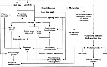
Currents play an important role in the unique ice conditions around Cape Dorset. The strength of the currents is related to different water depths, under which shallower water promotes the faster movement of water, keeping many areas ice-free year-round (AN1; EP1; JM1) (Fig. 13). For example, an aquanaq is described as a shallow area (likened to a reef) that creates stronger currents and can prevent ice from freezing solid (EM1). Due to relatively shallow waters around Cape Dorset, tidal variations are large (SS1). The cycle of high and low tides determine the direction of currents, as they go back and forth typically in a north/south alternating pattern (AA1; EE2; MK1; OO1). The water is described as moving towards the north (up/in) at high tide, and towards the south (down/out) at low tide, approximately every 12 hours. Beyond the daily high and low tide cycles, the monthly new and full moons are especially influential on current strength (i.e. peak high and low tides), and thus ice conditions (Fig. 13) (AN1; EE1; EE2; MS1; NP1; Pootoogook Reference Pootoogook2005 (PP2); SS1; QT2; SK1).
Conceptual model depicting the influences of currents and tides on sea ice formation, movement, or decay based on interviews conducted in Cape Dorset. Where: a solid line = general process direction, a dashed line = daily cycle, a dashed and dotted line = monthly cycle.

Current and tidal influences on ice conditions or movement
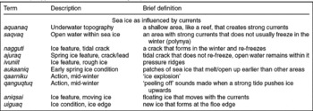
In this section concerning the influences of currents on ice conditions/movement, Table 6 and Fig. 13 should be consulted as references for Inuktitut terminology and links between processes.
Inuktitut terminology, descriptions, and brief definitions for sea ice conditions associated current/tidal influences (in approximate order as shown in Fig. 13).

Generally, the stronger the currents the harder it is for ice to form (Fig. 13). Hudson Strait currents are significant contributors to the maintenance of the sinaaq close to town throughout the winter, and the annual creation of saqvait (plural of saqvaq, likened to polynyas) (AA1; EM1; EP1; MS1; OO1; PP1; PP2; QT1; SK1). Ice is more likely to form in inlets, but not usually up to the points of land as that is where currents tend to be strongest (EP1, PP1, PP2, QT1) (Figure 15).
The ice will form mainly around the edges, because it's all currents on [the West] side. Mainly around the edges . . . in between these two islands it doesn't usually ice in between there. So mainly close to the mainland here, it will form only mainly in inlets because there's too much currents . . . It doesn't go, even most places it doesn't go right up to the points, just the little inlets will be ice (Petaulassie Reference Petaulassie2004a).
Between islands the currents are also very strong, as they are funnelled through narrower areas (PP2; SS1). This funnelling action results in thinner ice or more frequent formation of naggutiit (EP1; SS1) (Fig. 13). In addition, strong currents cause ivuniit to form along the coastline, along the sinaaq, or in areas where tidal cycles cause ice to collide or break off (AA1; AN1; MK1) (Fig. 13).
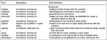
Inuktitut terminology, descriptions, and brief definitions for moving ice.

The Inuktitut term for polynya, saqvaq, actually refers to areas ‘where there are currents’ (not necessarily areas that never freeze over). It is well understood around Cape Dorset that areas of strong currents prevent ice formation, and keep certain areas ice-free throughout the winter, although they are surrounded by tuvaq. However, along with the varying strength of currents during a month, varying degrees of ice cover may form over a saqvaq. A notoriously dangerous area for saqvait, or thin ice conditions, is Saqvaq Inlet (Chorkbak Inlet on the map) (fig. 14a). Areas of open water were indicated throughout the inlet, and between the myriad of islands in the area. Therefore, this inlet tends to be avoided when travelling to Kimmirut (a neighbouring community to the southeast of Cape Dorset). There is one small area near the mouth of the inlet that does freeze over at times (nunniq), and thus becomes passable (PP2). But elders warn that this area is still very dangerous if the person is not familiar with conditions around the inlet (PP2). Saqvait are also scattered throughout the region, predominantly between islands and in narrow areas where currents are perpetually strong. Interviewees indicated several important saqvait near Cape Dorset, known as both dangerous for sea ice travel and as popular for seal hunting (fig. 14b). To identify a particular saqvaq, the closest place name on the land is used, and added to the term saqvaq (QT1).
Maps showing prominent saqvait around: a) the Chorkbak Inlet area; and, b) the Cape Dorset area. These are dangerous if the person is not familiar with the conditions around these saqvait. Sources: AA1; AN1; EE1; EP1; JM1; MJ1; MK2; MS1; MS2; OM2; PP1; PP2; QP1; QT1; SK1.

The monthly new and full moons create peak tidal stages where stronger currents contribute to: i) ice thinning; ii) more dangerous sea ice travel; iii) the opening or creation of naggutiit; iv) the opening or formation of saqvait; and, v) ice break-off events (AN1; EE2; MS2; NP1; PP1; PP2; QT2; SK1; SS1) (Fig. 13).
[E]specially when it's full moon season, that's when the currents start moving a lot, that's when [certain] areas are no longer safe to be travelling through, full moon season. And the new moon season is same as, almost like a full moon, ‘cause the tide is not as low as it would be when it's regular low tide (Saila Reference Saila2004).
Seasonally, in mid-winter a full moon can create such tidal pressure under the ice that an explosion of sorts (qaarniku) may occur, but not on a regular basis (EE1). Also, at the end of a very strong (high) tide, currents can lift up ice that was frozen to the ground, making loud ‘peeling off’ sounds (a process referred to as qanguqtuq), likened to the sound of loud snoring (Fig. 13) (AA1; Manning Reference Manning2005b (JM2)). Furthermore, full moon effects in the spring contribute to enhanced ice thinning from underneath the ice surface, and cause water to come up through holes in the ice (EE2). Currents may also be stronger in the spring, which can expedite melt processes and/or break-up (AN1).
Currents also influence sea ice movement. Usually movement delays ice formation in the autumn (QT1), but currents may also promote freezing if they deposit ice in areas with weaker currents, in which they can freeze (JM1; MJ1; MK1; QT1) (Fig. 13).
[W]hen it comes to icing in the fall time, currents have something to do with ice forming in some areas, where it would not ice right away the current has moved a chunk of ice into that area and now it's permanent in that area. The currents have something to do with ice forming in areas where it wouldn't have frozen right away because there's currents in the area. But sometimes the currents take ice to [where] it will stick . . . That's why some areas are a lot thicker than [other] areas (Tapaungai Reference Tapaungai2004).
Currents can take frozen piled ice to another area where it will stay (sikuliaqta), if the winds are not strong (MK1). Furthermore, in the spring currents can speed up the melting processes, and create aukaaniit (Figs. 10, 13). In addition, floating ice tends to follow the currents, as associated with the tidal cycle (EM1). A few key terms associated with moving ice (aulaniq) are provided in Table 7. Specifically, qapvaq (likened to multi-year ice) is associated with hampering sea ice or boat travel.
[Q]apvaq, they're big, like Hudson Strait polar ice, they're really clear white blue colours . . . when people see that say ‘oh oh, we're going to get trapped’. Because when they start to see that qapvaq [it] means a big area of ice like that can move into your area and block off all the shoreline. That has happened here, we got stranded out right here one time, with qapvaq. And then it stayed there over almost two weeks (Manning Reference Manning2005b).
Both currents and winds clearly influence sea ice movement, formation, decay, and distribution. In addition, their strength or direction varies with weather, lunar, and seasonal cycles, enhancing the complexity of understanding local sea ice freezing and melting processes. These dynamic influences are also continually considered when travelling or hunting on the sea ice, as they can greatly enhance the danger of sea ice navigation.
Discussion and conclusions
In using sea ice extensively for travel and hunting purposes, Inuit elders and hunters in Cape Dorset have developed a detailed and nuanced understanding of freezing and melting processes. Specific Inuktitut terms are used to describe various ice conditions and transition stages that occur throughout the annual sea ice cycle of formation and decay. These also link to the floe edge, tidal cracks, and polynyas, as influenced by wind and current conditions. Such characterisations of freeze/thaw and dynamic processes provide a unique glimpse into the localised conditions and marine geography of the sea ice surrounding Cape Dorset, and extending along the northern Hudson Strait coastline. This local scale understanding is critical for Inuit elders and hunters in evaluating ice conditions related to travel safety and marine wildlife hunting/habitat (Laidler and Elee Reference Laidler, Elee, Riewe and Oakes2006). Beyond community-based applications, these results also have the potential to inform future research efforts on: i) local/regional sea ice monitoring; ii) the relationship between Inuit knowledge, language, and the environment; and, iii) addressing community interests through targeted studies.
First, sea ice monitoring is often undertaken at coarse spatial scales (>25 km2 resolution), using passive-microwave (radar) satellite sensors (with hemispheric to regional coverage) (Mysak and Manak Reference Mysak and Manak1989; Wang and others 1994; Mysak and others Reference Mysak, Ingram, Wang and Baaren1996; Parkinson and others Reference Parkinson, Cavalieri, Gloerson, Zwally and Comiso1999; Parkinson Reference Parkinson2000; Heide-Jorgensen and Laidre Reference Heide-Jorgensen and Laidre2004). These data provide a useful overview of ice conditions (presence vs. absence, ice concentration, ice extent), and permit extensive spatial coverage for temporal trend analysis. However, Cape Dorset is included within the regional delineation of Hudson Bay (Mysak and Manak Reference Mysak and Manak1989; Wang and others 1994; Mysak and others Reference Mysak, Ingram, Wang and Baaren1996; Parkinson and others Reference Parkinson, Cavalieri, Gloerson, Zwally and Comiso1999; Parkinson Reference Parkinson2000), and the trends in ice coverage and freeze/thaw processes do not adequately capture the dynamics and ice movement in Hudson Strait. Heide-Jorgensen and Laidre (Reference Heide-Jorgensen and Laidre2004) provide a subset analysis of the fraction of open water present in sea ice around Baffin Island, which is useful in evaluating regional sea ice trends for south Baffin Island. In addition, Gagnon and Gough (Reference Gagnon and Gough2005) present a regional analysis of Hudson Bay freeze-up and break-up trends (not including Hudson Strait) and Gough and Houser (Reference Gough and Houser2005) analyse Hudson Strait sea ice formation and retreat along with the length of the ice-free and ice-covered seasons. These last two studies employed Canadian Ice Service sea ice chart data, which is derived from a combination of satellite imagery, image interpretation, and ship- and aircraft-based observations (EC, 2003). These studies provide increased spatial resolution, but still this data is not easily translated into meaningful information that can be used at a community level to evaluate ice conditions within the regional vicinity used for travel and harvesting purposes. A few notable exceptions include: i) Higgins’ (Reference Higgins1968) local characterisation of Cape Dorset ice conditions and freeze/thaw processes/timing based on in situ observations and measurements; and, ii) Environment Canada's local ice monitoring programme (which was cut in the mid-1980s along with federal budget reductions and increased automation of weather forecasts)(E. Bell, personal communication, 2005). Both of these exceptions are temporally constrained, and are thus not of direct relevance to contemporary sea ice conditions and uses. But active hunters are continually observing and monitoring the ice as an inherent part of travelling and hunting safely on the sea ice. Inuit hunters and elders rely on their own experience and expertise to determine the local safety and stability of ice conditions (Aporta Reference Aporta2002; Gearheard and others 2006; Laidler and Elee Reference Laidler, Elee, Riewe and Oakes2006; Meier and others Reference Meier, Stroeve and Gearheard2006). And it is this local scale that is most difficult to capture remotely, or with sporadic scientific field campaigns (and point measurements). Therefore, Inuit expertise has the potential to inform scientific studies of locally important sea ice features/processes often lamented as lacking due to inadequate sensor resolution or inability to conduct frequent and extensive ground verification. Hunters are the experts on these localised ice conditions, and they feel that if they are not consulted in related studies or monitoring activities, that scientists are missing a great deal of important information (Laidler Reference Laidler2006b). Nevertheless, community members have also expressed interest in learning more about scientific research findings, and gaining access to satellite images that represent areas of interest in the Hudson Strait region (Laidler Reference Laidler2006b). This would allow community members better to assess areas they cannot see prior to travelling and, with two-way communication, could help scientists to refine monitoring programmes or image interpretation based on local observations. There may thus be new opportunities for collaboration under which local monitoring programmes, such as described in Tremblay and others (2006), could be implemented to complement regional-scale satellite image acquisitions (for example Meier and others Reference Meier, Stroeve and Gearheard2006) or ice chart analysis (for example Gough and Houser Reference Gough and Houser2005).
Second, research on the relationship between Inuit knowledge, language, and the environment has evolved through land use studies undertaken as part of the land claims process in Nunavut (Freeman Reference Freeman1976), and more recently in investigating Inuit oral history, placenames, navigational skills, and astronomy (MacDonald Reference MacDonald1998; Aporta Reference Aporta2003; Aporta Reference Aporta2004; Bennett and Rowley Reference Bennett and Rowley2004; Aporta Reference Aporta2005; Henshaw Reference Henshaw2006). Specifically in relation to sea ice knowledge and terminology, it becomes evident that the use of the sea ice, Inuktitut terminology, and cumulative personal/shared experiences combine to contribute to the development of a hunter's sea ice expertise (Freeman Reference Freeman, Cooke and van Alstine1984; Riewe Reference Riewe1991; McDonald and others Reference McDonald, Arragutainaq and Novalinga1997; Aporta Reference Aporta2002; Gearheard and others 2006). These elements of engagement and language are inextricably linked, and cannot be divorced from one another. As Henshaw (2006: 52) describes: ‘ . . . Inuit ways of knowing their world come to life through an active engagement with their surrounding environment, informed by experience, observation, and language.’ She suggests that place-names (toponyms) represent one cultural manifestation through which Inuit express such an engagement. We suggest that sea ice terminology is another such manifestation, in which Inuit express their engagement with the dynamic sea ice environment through detailed descriptions of seasonal sea ice processes and features. Sea ice terms not only evoke a picture of particular ice types (through the literal and descriptive nature of Inuktitut), the quotations used throughout this paper highlight the expression of sea ice dynamism, seasonality, danger, and utility, especially for those familiar with the context in which terms are being used. Henshaw (Reference Henshaw2006) also found that embedded within some place-names are climate sensitive features such as sea ice conditions, or ocean currents. Therefore, we propose that combining sea ice terminology and dynamic descriptions with extensive place names research such as Henshaw has undertaken, can provide an enriched understanding of relationships between Sikusilarmiut (people of Cape Dorset, Sikusilaaq), their (changing) uses of the land and sea, physical terrestrial and marine geographies, and the evolution of local Inuktitut dialects. Like Henshaw (Reference Henshaw2006), it is acknowledged that mapping and terminology documentation cannot do justice to the dynamic nature and use of both the sea ice environment and the Inuktitut language, but it is a valuable starting point. Terminology lexicons and maps may enable improved communication with those who are unfamiliar with the language and/or the local environment (for example some Inuit youth, researchers, and government officials). By documenting sea ice terminology, it is also hoped that this work can contribute to broader efforts to preserve languages and knowledge of the north (Dorais and Krupnik Reference Dorais and Krupnik2005), an aspect of great concern to the elders and hunters who were part of this project.
Finally, an improved understanding of locally important sea ice conditions could help create targets around which to develop future research. One example that arose in interviews and meetings was the importance that community members placed on knowledge documentation as a means of enabling their expertise to be represented in writing, and on maps (Laidler Reference Laidler2006b). They felt that this would help them to be taken more seriously by youth involved in the formal education system, and by scientists working in their community (Laidler Reference Laidler2007). Great educational potential was seen in the recording of terminology and sea ice conditions/uses/hazards. With this baseline material, there is potential to develop interactive educational tools through a combination of Geographic Information System (GIS) and Global Positioning System (GPS) data, Inuktitut terminology and descriptions, photos of sea ice conditions, audio and video footage of interviews, sea ice trips, and focus groups, along with written transcripts and reports. Interactive multimedia, especially where maps and GPS or remote sensing technology have been incorporated with audiovisual material, have proved especially effective at engaging Inuit youth in a form of learning that is a compromise between the long-term experiential in situ learning of more traditional times, and the formal text-based learning of the southern-style education system predominantly in place in Nunavut (Fox Reference Fox2003; Aporta Reference Aporta2005; Gearheard 2005; NRI 2006). Furthermore, multimedia elements can more effectively portray the dynamics of the sea ice environment (for example, animated sea ice motion on maps), along with the interpersonal relationships and social learning that are necessary in the context of sea ice use (for example, watching a video of a local elder describing a sea ice condition).
A second example would be a research emphasis on local marine birds and mammals that are important for community subsistence and commercial harvesting, along with being tourist attractions. The importance of incorporating Inuit knowledge into wildlife research or co-management practices has already been demonstrated in other Nunavut communities (for example Wenzel Reference Wenzel1991; Nakashima Reference Nakashima and Inglis1993; McDonald and others Reference McDonald, Arragutainaq and Novalinga1997; Kilabuk Reference Kilabuk1998; NWMB 2000; Furgal and others Reference Furgal, Innes and Kovacs2002; Peter and others Reference Peter, Ishulutak, Shaimaiyuk, Shaimaiyuk, Kisa, Kootoo and Enuaraq2002). The results presented here inform related research being undertaken better to understand Inuit expertise on the linkages between specific sea ice conditions and wildlife habitat, behaviour, and health. In addition, local tourism revolves not only around the presence of cultural heritage, art, arctic wildlife, and vast expanses of impressive land-, sea-, and skyscapes (Milne and others Reference Milne, Ward and Wenzel1995; Doubleday and others Reference Doubleday, Mackenzie and Dalby2004; Laird Reference Laird and Dewar2004), but also the ability to access those locations. Sea ice can provide an important platform that facilitates, or hinders, access to such sites. As such, tourists may gain an enhanced cultural experience, and perhaps added personal safety, by travelling with experienced guides and having some community-specific sea ice background information available to them.
A third example relates to community interests in climate (and related sea ice) change. Incorporating Inuit expertise on localized ice conditions could complement scientific research on similar topics at coarser scales (Riedlinger and Berkes Reference Riedlinger and Berkes2001; Fox Reference Fox, Krupnik and Jolly2002; Gearheard and others 2006; Henshaw Reference Henshaw2006; Laidler Reference Laidler2006a; Laidler and Elee Reference Laidler, Elee, Riewe and Oakes2006), and could provide an enhanced perspective on how such changes may affect socio-economics and the sustainability of northern lifestyles and culture (Riedlinger Reference Riedlinger1999; Riedlinger Reference Riedlinger2001; Duerden Reference Duerden2004; Ford and others Reference Ford, Smit and Wandel2006a; Ford and others Reference Ford, Smit, Wandel and MacDonald2006b; Gearheard and others 2006; Nickels and others Reference Nickels, Furgal, Buell and Moquin2006). For climate change vulnerability research that promotes the characterisation of current exposure and adaptation from both physical and social perspectives (Ford and Smit Reference Ford and Smit2004), local Inuit experts have much to contribute. Yet, there is little of this community-specific knowledge available in the literature. In Cape Dorset, the location of, and dynamics along, the tidal zone, the sinaaq (floe edge), naggutiit (tidal cracks), and saqvait (polynyas) are of particular importance. Such local characterisations could be used to help contextualize changes that are currently being experienced by community members (Laidler and Elee Reference Laidler, Elee, Riewe and Oakes2006), or as indicators to target future monitoring or change assessment research to reflect community interest. Additionally, there are instances where community members are unsure of how long-term or seasonal sea ice variations affect specific ice conditions/movement. In these cases, targeted remote sensing or point instrumental measurements could aid in explaining phenomena that are difficult to observe through tactile or visual means (for example ocean current strength/direction changes, lunar effects, atmospheric oscillations, ocean temperature, air temperature, wind strength/direction, long-term trends). Therefore, researcher-community interactions and collaborations are essential to the success of such multidimensional research, which can begin to be fostered through baseline documentation research such as undertaken in Cape Dorset. Having a better grasp on how community members use, monitor, and evaluate ice conditions, makes it is easier to identify areas of overlapping interest with other researchers or community experts.
Through this discussion, an attempt has been made to highlight a few of the ways that community-based sea ice research can contribute to a broader context of northern research or community initiatives. Community members want to work with researchers, and to have their expertise considered alongside scientific expertise, especially where addressing local interests or concerns (Laidler Reference Laidler2006b). Working together is essential to understanding the potential implications of sea ice change for northern peoples and environments, but working together must start by mutual understanding. Therefore, it is hoped that this paper can provide a starting point for future cross-scalar investigations that would incorporate marine environmental trends, wildlife and human health, socio-economic implications, and socio-cultural perceptions/connections as interrelated with the sea ice environment around Cape Dorset.
Acknowledgements
We are grateful for the support and collaboration of community members and local organisations in Cape Dorset that made this research possible, most notably the elders and hunters who shared their knowledge through interviews and sea ice trips. Special thanks also go to the Hamlet of Cape Dorset, the Aiviq Hunters and Trappers Association, Huit Huit Tours, the local Qikiqtani Inuit Association, and the Nunavut Arctic College Community Learning Centre which helped facilitate this work and/or provided interview and meeting space. Interviews conducted were in compliance with ethical protocols at the University of Toronto, and were conducted under a multi-year Nunavut Research Licence (#0100504N-M, January 2004– December 2006). Financial support for this research was provided by: a Social Sciences and Humanities Research Council (SSHRC) Doctoral Fellowship, ArcticNet Theme 4.2, the Cryosphere System in Canada (CRYSYS), the Northern Ecosystem Initiative (NEI), the University of Toronto, a Society of Women Geographers (SWG) Evelyn Pruitt Scholarship for Dissertation Research, an Integrated Management Node (a part of the Ocean Management Research Network (OMRN)) student seed grant, and the Association of Canadian Universities for Northern Studies (ACUNS) Canadian Polar Commission Scholarship. We also thank two anonymous reviewers for their helpful comments in refining this manuscript.