The relationship between social organization and spatial configuration in contemporary and ancient cities is broadly recognized in archaeology (e.g., Fisher and Creekmore Reference Fisher, Creekmore, Creekmore and Fisher2014; Smith Reference Smith2020) and urban studies (e.g., Hillier and Hanson Reference Hillier and Hanson1984; Lawrence and Low Reference Lawrence and Low1990). Generally, these studies have focused on the distribution of architecture, material scatters, or both as markers of different economic and cultural activities (Pollard Reference Pollard, Sanders, Mastache and Cobean2003; Smith Reference Smith2010). Less commonly studied, however, is the movement infrastructure, such as roads and intersections, that served to connect or restrict access to different religious, economic, and social areas of a city (but see Alcock et al. Reference Alcock, Bodel and Talbert2012; Mendoza and Jordan Reference Mendoza, Jordan and Helaine2008) or the relationship between these features and the development, maintenance, and emergence of social organization (Shaw Reference Shaw2008). The relatively recent studies of the ancient city of Angamuco in Michoacán (AD 250–1530) and its well-preserved architecture, including its road network, provide a unique opportunity to address major questions concerning the development, function, and interconnection of architectural features and social organization (Fisher and Leisz Reference Fisher, Leisz, Comer and Harrower2013; Fisher et al. Reference Fisher, Cohen, Solinis-Casparius, Pezzutti, Bush, Forest and Torvinen2019). However, there are several challenges to studying movement infrastructure in archaeology, including a lack of a working methodological and analytical framework along with issues of conservation. Thus, studying an ancient road network requires the development of criteria for the identification, classification, and archaeological investigation of roads, as well as the exploration of the roles of road networks in the establishment, maintenance, and transformation of social organization through time. In this article I develop a research framework with the goal of investigating patterns of urbanism, evidence of planning or designing of roads, and temporal development of a road network in an archaeological setting.
Urbanism and Road Networks
Human settlements represent distinct and complex sociocultural systems expressed at many scales of organization, production, distribution, and consumer practices, regardless of their size and location (Cowgill Reference Cowgill2004; Smith Reference Smith2003, Reference Smith2011). Roads are a part of the spatial expression of these systems because they define access to architecture, resources, and the natural landscape. In archaeology, roads most often have been seen as the byproduct of the movement of people and goods. Roads are also on occasion conceived of as spatial divisions within a city (Blanton and Fargher Reference Blanton and Fargher2011). However, roads are structures resulting from individual decisions that are regularly influenced by social norms. As such, their placement, use, construction, and maintenance correspond to a combination of complex cultural, economic, and political factors that are determined within the community (Cobos and Winemiller Reference Cobos and Winemiller2001; Erickson Reference Erickson, Snead, Erickson and Andrew Darling2009). Focusing on how roads are created and used and the potential activities that they may have enabled offers the possibility to better understand fundamental dimensions of socialization and urban development. For example, some roads, like large causeways, attest to the massive involvement of commoners in their construction (Hutson Reference Hutson and Stanton2014). Their placement and connectivity define social roles (such as who can access resources and linkages between polities), decisions of the ruling classes (Keller Reference Keller, Lecount and Yaeger2010), rites of passage and rates of exchange (Edmonds Reference Edmonds and Tilley1993), and negotiation and political instability (Hutson et al. Reference Hutson, Magnoni and Stanton2012). Thus, the urban layout—the natural landscape, architecture, and road network together—is a key element for investigating how cities were internally structured and how social groups were defined in a settlement (Maca Reference Maca2002; Stark Reference Stark1998).
Recent work on ancient Mesoamerican urban centers that has focused on domestic venues like households and neighborhoods sees cities as the result of both top-down and bottom-up processes (Marcus and Sabloff Reference Marcus and Sabloff2008). Organizational units occur through some combination of social categories (e.g., ethnicity, kinship, wealth, occupation, etc.), and their spatial expression varies across cities, regions, and time periods in Mesoamerica. These units include considerable face-to-face interaction where social contracts, norms, and identities are established, often reflecting how space is configured (Arnauld et al. Reference Arnauld, Manzanilla and Smith2012). These processes are made possible through the revisiting of places and constant interaction with other individuals and with material features, which help generate dispositions that guide behavior and thinking. Because this is a social process shaped by past events and structures, it is created and reproduced unconsciously and constantly (Bourdieu Reference Bourdieu and Nice1977). Examples of how social norms are intrinsically connected to the landscape are pointed out in the studies of quotidian spaces by Erickson (Reference Erickson, Snead, Erickson and Andrew Darling2009) and Thomas (Reference Thomas, Renfrew and Scarre1998) and by the work on community creation in the Andes by Hastorf (Reference Hastorf2003). In this sense, the urban layout is the spatial manifestation of socialization processes that include daily interactions, religious practices, production and consumption habits, and an important phenomenon often ignored in archaeology: movement behaviors.
How, then, are sociopolitical structures reflected in the landscape? Typically, three levels of social organization have been observed in Mesoamerican cities: (1) the state-directed level, such as elite versus commoner residences or centrally located religious and administrative structures; (2) the community-negotiated level, such as neighborhoods; and (3) the family-based level, which is similar to individual residential units and households. Importantly, many spatial expressions of these social organizations coexisted in the same urban settlement, and each one had its own set of social norms and organizational principles. This has been observed in complex cities like Teotihuacan, Cantona, Calixcahuaca, Chunchucmil, Mayapan, El Palacio, and other sites (e.g., García Cook Reference García Cook, Sanders, Mastache and Cobean2003; Jadot and Forest Reference Jadot, Forest and Forest2020; York et al. Reference York, Smith, Stanley, Stark, Novic, Harlan, Cowgill and Boone2010). In other words, studies in Mesoamerican urbanism suggest a significant variability of urban configuration (Monnet Reference Monnet, Sanders, Mastache and Cobean2003). However, despite this diversity, all cities spatially comprise the same three crucial elements: architecture (buildings associated with functions and activities), landscape (topography and natural resources), and the movement network that allows access through these spaces and features (Lynch Reference Lynch1984).
Thus, I propose that the movement infrastructure is fundamental to understanding the urban layout of a city and therefore its social configuration. With this in mind, I explored the urban road network at the site of Angamuco in Michoacán, in light of and in contrast to the current understanding of the sociospatial urban development of the region (Purépecha Empire).
The Archaeological Study of Urban Road Networks
To explore the roles of the road network in the urbanization process, I developed a project in 2016 centered on investigating the roads within the city of Angamuco in the Lake Pátzcuaro Basin. This city was incorporated into the Purépecha Empire around the fourteenth century but was settled several centuries earlier (Cohen Reference Cohen2021; Fisher et al. Reference Fisher, Cohen and Solinis-Casparius2016). Locating and measuring roads allowed me to analyze the use and development of the movement infrastructure. The main purposes of this research were to evaluate whether roads and road networks are useful in understanding the sociospatial configuration of cities and to explore other social phenomena associated with movement. This work centered on two objectives: identifying all the potential prehispanic roads at Angamuco and collecting data that would provide a better understanding of the morphological (shape), physical (dimensions), temporal (chronological markers), and experiential (effort, visibility, direction, etc.) characteristics of the road network.
As noted earlier, roads have been the center of other archaeological investigations in Mesoamerica in Caracol, Mayapan, La Quemada, Yo'okop, and Xochicalco. This is very valuable work, but the methodologies used were extremely varied, and the studies typically focused only on a few large roadways within a settlement (e.g., the major causeway near the ceremonial center) and not the whole road network. Thus, there is no standard methodology for the archaeological study of road networks in this or most other regions. One of the central challenges of this type of work is to clearly identify the roads within an ancient settlement. This is not only a problem of missing data (e.g., modern urbanization and land use eliminate traces of roads, roads are made of nondurable materials, vegetation growth obscures the roads) but also, as mentioned by Trombold (Reference Trombold1991), it is an analytical problem. There is a tendency to study roads as single units rather than as part of a network. As a result, they could be disassociated from the role they play within communication networks of an urban center. Excavation and survey are important to understanding the physicality and temporality of roads and to establishing parameters that identify where road segments begin, end, or are crossed (i.e., bends, abrupt changes in direction, breaks in the flow of traffic, dead ends, and entries into household complexes). Additionally, tools like GIS, lidar, and spatial and image analysis provide additional approaches to study complete road networks (Nuninger et al. Reference Nuninger, Verhagen, Libourel, Opitz, Rodier, Laplaige, Fruchart, Leturcq and Levoguer2020) or to model social configuration in the absence of physical evidence (see Llobera Reference Llobera2020).
Like any other archaeological artifact, road networks are composed of a series of parts that can be measured, categorized, and sorted. I studied the Angamuco road network as a system comprising two unique types of data: road segments (walking surfaces) and nodes (junctions where road segments end and start, also called crossroads or intersections). All other associated features of the movement infrastructure such as ramps, stairs, entrances, and walls were documented in a separate dataset. Using nodes and segments reduces subjectivity because it is not necessary to define a road conceptually a priori (e.g., “main road,” “access road,” and the like).
The analytical framework I employed has been used elsewhere through the adoption of geometric network analysis (Porta et al. Reference Porta, Crucitti and Latora2006), but to my knowledge, this is its first use in a Mesoamerican setting. Moreover, there is an absence of systematic workflows to investigate the independent qualities of both segments and nodes in an ancient road network. Thus, I designed this research on two scales—individual (roads) and global (the network)—according to the type of data to be collected and the kinds of interpretations they could provide. For the individual scale, I used field survey and excavation to document a sample of road segments at Angamuco and to examine their construction system, cultural deposits, and temporality. For the global scale, I used geospatial analyses and remote sensing to understand patterns of the morphology of the network and its different centrality qualities. It is important to note that temporal markers (e.g., 14C, seriation, and stratigraphy) were collected from elements of road construction; for a detailed discussion see Solinis-Casparius (Reference Solinis-Casparius, Ellis, DeSanto and Howey2022). In addition, the term centrality refers to characterizing the “importance” of nodes in a network (Borgatti Reference Borgatti2005). Such “importance” is defined in different ways, such as topological or geometric. Hence, several mathematical indices were developed to measure different aspects of a network's centrality (e.g., closeness, cohesiveness, reach, etc.) known as centrality indices.
Research was divided into two stages of computer analyses, one for the lidar survey and another for network analysis; both were performed at the Digital Archaeology Research Lab at the University of Washington. Additionally, one field session was performed after the lidar survey and before network analysis to field-verify, excavate, map, and document a sample of segments and nodes. I briefly describe these methods next, although this experimental approach is described in greater detail in Solinis-Casparius (Reference Solinis-Casparius2019).
Lidar Survey (Image Analysis)
Lidar has been used for identifying and measuring architectural features in archaeology for more than 15 years (Fernandez-Diaz et al. Reference Fernandez-Diaz, William Carter and Glennie2014) and recently at the neighboring region of Zacapu (Forest et al. Reference Forest, Costa and Pereira2018). A lidar dataset collected in 2011 by Christopher T. Fisher provided a high-resolution digital elevation model (DEM) of the terrain for the archaeological site of Angamuco (for the technical details of lidar data acquisition and processing, see Fisher and Leisz Reference Fisher, Leisz, Comer and Harrower2013; Fisher et al. Reference Fisher, Leisz and Outlaw2011). The area of research or boundary of the site was defined by the topography, field survey, and extent of the lidar scan. The DEM model is so precise that it can identify objects as small as a cinder block. Although there are several methods to identify topographic and architectural features, I used a combination of image analyses and modeling in GIS to find possible walking surfaces in Angamuco. In short, I first created different visualization rasters (Multidirectional Hillshade Maps and NegativeOpenness) that increase dominating surface concavities and convexities (see Yokoyama et al. Reference Yokoyama, Shirasawa and Pike2002). I then searched for narrow linear features and their intersecting points using an a priori set of visual/topographic conditioning factors (e.g., cannot go straight down/up on steep slopes, cannot cross through architecture). This work was done manually and included assigning several attributes (e.g., number of connecting segments) to the resulting points and lines in a vector dataset. The results provided the global road network of Angamuco.
Field Survey
Four randomly selected, nonadjacent areas of the site were systematically surveyed (Figure 1). This survey consisted of walking along a road segment while mapping it, using a submeter GNSS receiver, recording the road width with a tape measure, and collecting surface materials. A similar method was used for all nodes. Unique cases—for example, evidence of superposition of segments, elevated causeways, or entrances to household compounds—were also documented using photographs and their geolocations with GPS. Additionally, nine segments and nodes were excavated to document material deposits and construction methods, and to collect 14C samples for dating. Such data guided other work not discussed here (e.g., chronological determinations, ceramic analysis, modeling, image analysis, and space syntax) that requires its own in-depth discussion (Solinis-Casparius Reference Solinis-Casparius2019). This article centers only on the general characteristics of the global network as observed through network analysis.
Multidirectional Hillshade Map of Angamuco showing natural division (escarpment in bold black line), Upper and Lower Angamuco, entrances to site (stars), and areas of field survey for roads (in gray/red). A detail shows the density of architectural features in the site (mapped by LORE-LPB in 2013–2014). Proposed settlement model is on the right. (Color online)

Network Analysis
A final and standardized version of the complete road network vector dataset (segments in lines, nodes, and entrances to the site in points) was created after reconciling the results of both field and image analyses. This network was then used for several centrality and network analyses in GIS. Eight analyses were performed using several toolkits: Network Analyst for ArcGIS, UCL's Urban Network Analysis (UNA) for Rhino6 and ArcGIS, QGIS SpaceSyntax plug-in, and DepthmapX. Each one was unique and helpful in identifying distinctive characteristics of the road network: for example, in understanding the integration of the network (closeness and cluster), exploring accessibility (reach and gravity), modeling traffic flow (betweenness and redundancy), and seeking evidence of planning (straightness). Next, I focus on the general patterns of Angamuco'snetwork observed after lidar and field survey, as well as the main results of integration analyses.
Angamuco: A Case Study
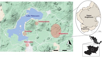
The site of Angamuco (AD 250–1530) is located on the eastern edge of the Lake Pátzcuaro Basin about 20 km northeast of Pátzcuaro and 10 km east of Tzintzuntzan, the first and last capitals of the Purépecha Empire (AD ~1350–1530; Figure 2). This empire covered more than 75,000 km2 of western Mexico and significantly influenced all settlements near the lake (Blanford Reference Blanford2014; Pollard Reference Pollard, Sanders, Mastache and Cobean2003). It is suggested that during state expansion (Late Postclassic or AD ~1350–1530), conquered polities maintained some form of local self-governance that incorporated elements of the Purépecha sociopolitical and economic way of doing things (Beekman Reference Beekman2009). Once incorporated into the empire, cities were reorganized into a pattern of districts, neighborhoods (defined by kinship, ethnic group, task specialization, tributary collection systems, or a combination of these factors), and a central ceremonial center including yácatas (Espejel Carbajal Reference Espejel Carbajal2008; Warren Reference Warren1985). Importantly, the sociospatial configuration of such Purépecha cities was not entirely the result of central planning (Pollard Reference Pollard, Sanders, Mastache and Cobean2003).
Map of the Purépecha Core-region around the LPB showing the locations of the three capitals of the empire (Ihuatzio, Pátzcuaro, and Tzintzuntzan) in circles and the location of Angamuco. (Color online)

Angamuco was first documented in 2009 during a regional survey by the Legacies of Resilience: The Lake Pátzcuaro Basin Archaeological Project (LORE-LPB). Preliminary results indicate that for much of the Postclassic period, the city had a population of approximately 30,000 inhabitants with an extensive built environment of more than 20,000 architectural features. The site is situated on a malpaís (mid-Holocene lava flow) with very dense vegetation and an overall size that exceeds 12 km2. The rugged terrain and shallow soil deposits have proven unsuitable for modern agriculture, which makes the overall urban layout (architecture) and road network identifiable on the surface (Figure 1).
Survey, remote sensing, excavation, and material analyses since 2009 suggest that large and organized polities may have developed at this site as early as AD 250, long before the formation of the Postclassic empire (Cohen Reference Cohen2021). Ongoing work indicates that Angamuco saw at least two important periods of urbanization: one occurring just a few centuries before the formation of the empire and another right after, bringing Purépecha traditions and architecture to the city (Fisher et al. Reference Fisher, Cohen and Solinis-Casparius2016). It is possible that other slower processes of settlement in the upper areas of the site occurred during the Classic period, but this has yet to be confirmed. The size, complexity, and organization of Angamuco demonstrate that it was an important urban center in Lake Pátzcuaro Basin during the period of empire formation within the region (AD 1250–1350).
Full coverage survey in 2009–2011 and aerial lidar scanning in 2010 and 2015 have made the dimensions of the city clearer. As a result, we have detailed coverage of 100% of the site through DEMs at high resolution (0.25 m). Overall, Angamuco resembles a densely urbanized city. All areas of the site were modified to accommodate ritual, residential, and economic-subsistence activities (Fisher Reference Fisher2011). For example, pyramids, plazas, and houses are located right next to each other throughout. Importantly, unlike other Purépecha cities, the site of Angamuco does not have a major ceremonial center, but it has a complex road network that includes road segments and nodes of different sizes and extensions covering the complete site.
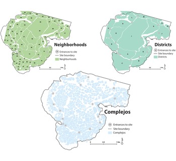
Before conducting this dedicated analysis of roads, the LORE-LPB project registered clusters of architectural features interpreted as sociospatial units following concepts of urban morphology and space syntax (Fisher and Leisz Reference Fisher, Leisz, Comer and Harrower2013; Fisher et al. Reference Fisher, Cohen, Solinis-Casparius, Pezzutti, Bush, Forest and Torvinen2019; Urquhart Reference Urquhart2015). These social clusters are defined through the combination of apparent road segments, natural topography, the built environment, and various semi-centralized and shared resources, such as pyramids, wells, and reservoirs. The combination of all these elements helped define three types of social units or scales of organization with no apparent standardized dimensions: (1) complejos, groups of houses and other architectural features; (2) neighborhoods, groups of complejos; and (3) districts, groups of neighborhoods (Figure 3). Before research was conducted on road networks, it was unclear whether road-like features acted as boundaries to social units, and if so, whether they were deliberately created and subsequently planned, constructed, and maintained or were the result of natural corridors, emergent self-organizing processes, or both. The study of the development and modification of the urban layout of Angamuco is critical to the understanding of the Purépecha Empire's influence here and in other sites in the region and, more broadly, to the exploration of the roles that road networks and the organization of the urban space play in urban settings.
Social divisions within the site of Angamuco. These divisions were proposed by Christopher Fisher and LORE-LPB prior to the study of roads. (Color online)

Three characteristics of Angamuco make it an important case study for understanding processes of urbanization. First, a natural escarpment that surrounds the entire site is about 50 m high and very steep (~60°), creating a natural boundary that divides the city into two sections, labeled Upper and Lower (see Figure 1). Roads cross this escarpment at 15 locations. I call these points “entrances” to the site. Second, the distribution of architectural features and resources, the lack of a clear civic-ceremonial center, and the level of integration of the road network (all areas of the city are virtually accessible to any user) suggest that this was a noncentralized settlement where some sort of community self-governance dictated the use of space and resources. Third, the generally unsophisticated construction styles and the availability of building materials (basalt rocks) allowed for easy and expedient construction and the modification of features by any member of the community.
Moreover, the site of Angamuco has remained virtually untouched from modern development and destruction, an extremely rare condition that allows it to be studied in or at least close to its original form. The site was also a very densely populated urban center with heavy landscape modification during its time of occupation. These conditions provide a unique opportunity to study the movement infrastructure. Next, I present the general conclusions from the field-survey analysis (the roads) and the main observations from lidar survey and network analysis (the network).
The Roads of Angamuco (Individual Scale)
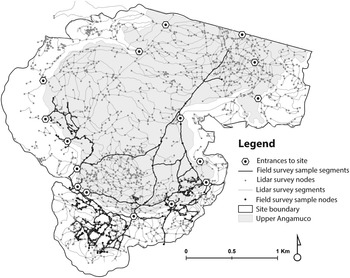
The basic unit of movement in a network is not a “road” but the road segments and nodes that together create routes. Hence, I use the term road here as a general concept rather than as an analytical unit. When needed I also distinguish observations of routes from those of segments and nodes. Importantly, to prevent an a priori interpretation, “roads” are neither considered as intentionally built features nor natural corridors: they are simply linear features that afford movement regardless of their architecture. In this sense, the research produced two route datasets. The first represents a sample of about 14% of the network (~1.6 km2 of the site). It includes 419 segments and 379 nodes registered, mapped, and measured directly in the field with a total extension of ~23 km. The second is the result of the digital extraction of 2,620 segments and 3,620 nodes for the complete extension of the site (~12 km2), with a total extension of ~157 km (Figure 4).
Map of road network of Angamuco. Field-survey sample (segments in black) and lidar survey sample (segments in gray).

I organized these two datasets into a road typology aimed at understanding variation and functionality within the network. It is important to note that because this typology was created from empirical data of Angamuco, its applicability to other contexts may be limited. Every road network has its unique features, and thus it is not always useful to adopt a road typology from a different setting. For example, urban and transportation studies base street organization on physical qualities, function, location, and other special conditions (Strohmeier Reference Strohmeier2016). These typologies aimed at modeling traffic and planning can be problematic in an archaeological context due to general assumptions about traveler behavior, function, or associated values (e.g., dangerous/safe roads).
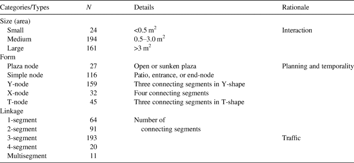
This research focused on exploring social interaction and patterns of urbanism through the configuration of the movement infrastructure, including whether evidence of planning and route selection could be identified in the archaeological record. Thus, I collected only observable physical attributes for each segment and node in the field and computer surveys. These data are summarized in 14 combined categories of attributes related to their size, topography, topology, and architecture (Tables 1 and 2). Ultimately, I produced five categories for segments based on width, shape, slope, the experience of travel, and construction style (see Hutson and Solinis-Casparius Reference Hutson and Solinis-Casparius2022). Nodes were organized into four categories based on area size, connectivity (how many segments they connect), shape, and topology. Each of these categories have their own set of types or classes, which are mutually exclusive and are not hierarchized.
Summary of Quantitative Data for Paths/Segments at Angamuco Arranged by Categories, Types, and Subtypes on Field-Verified Sample.

Note: Counts for experiential categories do not total 419 surveyed segments.
Summary of Quantitative Data for 379 Surveyed Nodes at Angamuco Arranged by Categories, Types, and Subtypes on Field-Verified Sample.

A number of important results can be obtained from looking at the distribution of segment and node types produced in the field survey (see Solinis-Casparius Reference Solinis-Casparius2019 for details): I present here the four most noteworthy findings:
(1) The roads within Angamuco (see Figure 5 for examples) developed organically over time and were mainly built by members of the community. Relating the width of the road to the number of users and the effort to build and maintain it, segments can be interpreted as private (called pasillos), community-used or semi-public (called senderos), and public roads (called caminos and calzadas). The most common type are senderos (>70%), which are suitable for traveling alone or with one other person (1–3 m wide); they were likely created and maintained by members of the immediate community (such as neighborhoods) through which they pass. These segments are short (~15 m average), of simple construction (one or two simple curbs), and generally follow the natural topography.
(2) About 50% of all the nodes within the site connect a total of three segments, and of those 82% are Y-nodes. Y-nodes connect three segments, and their shape is oblique or irregular. There are two subtypes of Y-nodes. The first subtype does not show any signs of hierarchy between the connecting segments. The second subtype has topological elements such as blockages, steps, ramps, or a clear difference between segment types that suggest that one segment was added to an existing road. In short, Y-nodes are a clear indication that roads were added to existing roads. Generally, creating pathways within Angamuco was not a consciously planned project but an opportunistic and organic process, with constant additions of routes over time as the population grew.
(3) There are many kinds of segments, which means that residents kept building new routes and were actively engaged in the transformation of their landscape. Only about one-third of the segments are flat (26%) or straight (41%), both characteristics indicative of strategic construction and planning. At least one-third of the network required the removal or excavation of sediments and rocks either at a small scale (likely managed within the community) or a large scale (perhaps directed by a central government). I further identified at least seven construction styles (e.g., raised roads, with curbs, with walls, paved, etc.; see Table 1). Although it is difficult to make sense of the most prevalent styles, at least 80% of the sample showed some evidence of construction, as opposed to simple trails of eroded walking surfaces that follow the topography. Interestingly, these seven construction styles seem to be somewhat standardized: ~45% of the sample are segments with curbs or walls. Roads with curbs are easy to build with small groups of people, which point to social structures of community engagement, in which styles of roads were copied or reused. The construction techniques also suggest different levels of work, from simple roads that required one person to build in only a few hours (e.g., stacking rocks to create the curbs) to large and complex projects, such as large ramps, for which hundreds of people and likely months’ worth of labor were required for construction.
(4) Nodes eased navigation within the city and acted as important locations to enhance daily interaction. Generally, nodes are exposed, so arriving at one allows travelers to see their travel options. Furthermore, 59% of nodes are either open or within 20 m of another node, so that it is possible to see the next node in at least one direction. More likely than not, pedestrians could see their next change of direction—due to proximity or openness—before they arrived at the next decision-making point. In other words, the nodes make the network more comprehensible and easier to navigate (Lynch Reference Lynch1960). Routes were visited so often that they might have been memorized by residents over time, yet the visibility and prevalence of nodes suggest that visitors or inexperienced travelers could create their own routes rather easily. Moreover, because the segments are usually wide enough for two people, there would have been plenty of opportunities to re-route one's travel. Additionally, about 40% of nodes are large enough (>5 m2) to accommodate social interaction and gathering. More work needs to be done to model locations for likely encounters and traffic accumulation; however, the large open areas at the ends of road segments seem like good candidates for expedient gathering places for trading, resting, or chatting, especially given the lack of sufficient monumental public spaces for such an urbanized city.
Three examples of roads at Angamuco. Walking surfaces enhanced in black-and-white (print) photos. Photos by Rodrigo Solinis-Casparius. (Color online)

In sum, the results from survey and mapping show a diverse yet somewhat standardized assemblage of roads (segments and nodes). This sample confirms that the road network is complex and resulted from a combination of direct engagement and planning for some (likely arterial) routes and less active or more expedient modifications of the natural topography for others. A dedicated analysis of segments and nodes illustrates that the inhabitants of Angamuco created new access routes as the population grew and settled in new areas of their city. This becomes even more apparent when the network is explored as a global system.
The Road Network of Angamuco (Global Scale)
Angamuco's road network is complex, diverse, and extensive. This becomes clear after the identification of all potential prehispanic roads through image analysis and modeling and after dedicated spatial and network analyses. As previously mentioned, the distinct characteristics of the roads already suggest the development of the site and its internal accessibility. Yet, a global perspective required an extraordinary body of data to further investigate Angamuco's urbanization and other movement behaviors.
Urban networks have unique properties that help shape social phenomena motivated by patterns of mobility. These properties may be geometric (how the network is configured) or functional (how the network works). For example, the shape and function of an urban road network influence people's choices on how and where to move, favoring certain patterns of mobility and thus affecting the settlement process of a place. For this study, I used urban network analysis (UNA), a set of GIS tools designed to explore centrality indices within a geometric network in urban settings (Sevtsuk and Mekonnen Reference Sevtsuk and Michael2012). Details of the methods and parameters can be found in Solinis-Casparius (Reference Solinis-Casparius2019). In this section I summarize and discuss the general conclusions, specifically relating to the morphology of Angamuco's road network, its extension, integration, configuration patterns, and role in defining the urban layout of the city.
Extension of the Network
The road network covers all areas of the site. Lidar survey produced a total of 12,834 km of walking surfaces comprising 2,620 segments and 3,620 nodes (Figure 6). About 85% of the segments are connected between them (gaps smaller than 1 m) and to the farthest nodes (end-nodes) at the edges of the site. This allows for almost all locations of the site to be reached using the recorded roads. Thousands of diverse road options depending on size, direction, and centrality have the potential to create multiple route choices for any given trip. This complexity makes the network very versatile.
Integration map of Angamuco with nodes and segments symbolized according to their closeness values. The lower the closeness value, the more integrated they are to the network. Detail shows an area where several segments are not connected to the network (less integrated). (Color online)

Even though the network seems cohesive, dedicated analysis was necessary to determine whether all areas of the site could be considered part of the same unique and global network. Two inquiries were set for exploring the level of integration of Angamuco's network. On a global scale, I wanted to find out whether sections of the network showed different morphological patterns or whether the entire network had a more uniform pattern. I additionally wanted to explore whether sociospatial units (complejos, neighborhoods, or districts) could be distinguished by looking at how their road networks are configured internally, as was originally speculated by LORE-LPB. I used integrity analysis for the former, and closeness and cluster analyses for the latter.
Integration of the Network
Integration refers to the number of steps that it takes to get from one location to any other in the network (Tencer Reference Tencer2016). The lower the total count of these steps, the more integrated the network. The number of steps (turns, decisions, changes in direction, etc.) can be correlated to levels of movement—at the very least, how fluid the movement is for pedestrians—and thus create a model of movement.
A more integrated network would mean less time spent on deciding how to get to a destination or to route-changing locations (nodes). In other words, a well-integrated network is also an efficient network and may suggest some level of planning or a robust social structure. The global value of integration of the network was calculated using DepthmapX by computing the extent to which any segment is connected to every other segment in the network using the shortest path for each route. At this global scale, segments and nodes have an average value of integration of 0.854496, which means that ~85% of the segments are integrated to the network and only fewer than 15% are segregated or not connected. Thus, Angamuco's network as a whole is well integrated, and virtually any location (node) is connected to the network. The few sections of the network that seem segregated are all located near modern urbanization, which explains why segments and nodes are now missing or hard to identify in the DEM. In general terms, Angamuco has a well-integrated network that could be interpreted as being uniform. The next analysis helped further explore this quality.
Closeness of the Network
Closeness is a centrality index that calculates how close a location is to all other locations (e.g., nodes, buildings, complejos, etc.) within a given distance threshold. Generally used to measure buildings’ proximity in spatial network analysis, closeness has been defined as the shortest average of the sum of segment distance (as opposed to straight lines) from one location to any other in the network (Crucitti et al. Reference Crucitti, Latora and Porta2006). It can be interpreted as how close locations are to each other; for example, exploring how integrated complejos are within the network. The lower the closeness value of a complejo (i.e., its centroid), the shorter the average distance from that complejo to any other surrounding complejo. In other words, the lower the closeness value, the more integrated. Thus, such a complejo would be better positioned to facilitate close interaction among inhabitants of neighboring complejos.
In Figure 7 (bottom), closeness has been calculated for all complejos at a network radius of 500 m (or about a 15-minute walk using only roads). Complejos located at the edges of the site that are not surrounded by other complejos are less integrated to the network. In general terms, it seems that the complejos located in the center of the site are more integrated to the network (in dark gray/green): the residents of such complejos would reach neighboring complejos easily and with more chances of encountering neighbors than would residents of complejos in the peripheries of the site. What seems to be a better determinant for the integration of complejos is not necessarily their location within the site but a combination of two aspects: their centroid's proximity to a well-integrated road segment and how dissimilar this proximity distance is to the average distances of neighboring complejos to well-integrated road segments.
Closeness analysis on centroids of complejos at a radius of 250 m (top) and 500 m (bottom). The lower the closeness value, the more integrated they are to the network. (Color online)

These two factors are more evident when the radius is decreased in the closeness analysis; for example to 250 m or about an 8-minute walk (Figure 7, top). In this case, instead of seeing integration at a global scale, it is possible to see that groups of complejos share different levels of closeness, something that could suggest a spatial relationship of these groupings, similar to that of neighborhoods suggested by Fisher (Reference Fisher2011) and Urquhart (Reference Urquhart2015). In other words, closeness of complejos can be used to suggest a simple patterning of spatial association. Similarly, neighborhoods and districts (Figure 8) show a varied level of integration, which again might suggest that although these groupings of spatial features are well integrated at a global scale in the network, moving through them differs from one district/neighborhood to another.
Closeness analysis on centroids of neighborhoods at a radius of 1,500 m (top) and districts at 2,500 m (bottom). Lighter neighborhoods and districts are less integrated to Angamuco's road network. (Color online)

In sum, the complejos are generally well integrated, with ~95% of them having a closeness value of 0.0005 or lower (for a radius of 500 m and higher). That is, it takes longer to walk to the centroid of fewer than 30 complejos from a road in the network than to any other adjacent complejo. Although this analysis does not confirm that complejos are located according to sociocultural associations, it does suggest that the entire network is well integrated and that its configuration might explain settlement patterns, especially at larger scales of integration; it also suggests the lack of a more centralized civic-ceremonial center. Cluster analysis helps explore this patterning further.
Clusters in the Network
Spatial clusters—or aggregations of buildings, nodes, and segments—illustrate physical groupings of features that suggest patterns of urban layouts (e.g., orthogonal, radial, etc.). For example, it is well known that housing patterns (e.g., distribution of buildings, rooms, and even the shapes of houses) correspond to periods of urbanization (Smith Reference Smith2010) and social cohesion (Carballo Reference Carballo2010). Either informal or planned housing arrangements can reflect cultural affiliations or trends of adaptation to the landscape (Harrison Reference Harrison2016; Manzanilla Reference Manzanilla, Ruiz, Ponce de León and Martínez Martínez2001). One characteristic of spatial patterning is the distance between architectural features and, therefore, the roads that connect them. Cluster analysis reveals spatial aggregates that could be interpreted as promoting social/cultural cohesion or revealing the spatial distribution of urban communities.
Two criteria need to be defined for cluster analysis: the minimum number of locations that constitute a cluster and the maximum allowable network distance from each location (member of the cluster) to at least one other location in the same cluster (Sevtsuk and Mekonnen Reference Sevtsuk and Michael2012). I used nodes as locations within a neighborhood scale. This approach has potential because most internal paths are too small (<0.50 m width) to be identified through the digital road extraction, making complejos too small of a scale for this type of analysis.
I calculated the minimum, maximum, and average architectural features, nodes, and segments for a random sample of five neighborhoods where such data were available. With a minimum of 25 nodes per neighborhood and a maximum distance of 90 m between each node, the cluster analysis reflects a configuration of neighborhoods initially suggested by LORE-LPB (Figure 9, right). These clusters do not align with the neighborhood boundaries exactly but suggest a level of integration in two important areas of the site: a south-central region (SoC) and a northeastern region (NoE; Figure 9, left).
Left, general patterns of the network showing dense areas (SoC and NoE). Right, density analysis showing total counts of segments per complejo and per neighborhood at Angamuco. (Color online)

Network Morphologies
Finally, looking at the shape of the network it is possible to identify at least two patterns of road development at Angamuco (for a discussion of the main arteries see Solinis-Casparius, Reference Solinis-Casparius2019). In this sense, two other UNA analyses of cluster and closeness revealed what I call dense and sparse network patterns. A dense network pattern is characterized by a high density of segments and nodes within an area. Topography seems to be a factor in determining the location of dense network patterns. Dense networks are composed mostly of senderos (1–3 m wide segments) and are not necessarily located near entrances to the site but are aligned with or centered by a main road.
I identified two areas of dense network patterns in the site: a northeastern (~0.5 km2) and south-central (~0.65 km2) region (Figure 9, left). These are the same two areas observed through cluster analysis. If there are at least two patterns of road network configuration, and if roads are directly related to the settlement of houses, then it is likely that these two areas point to communities with different social configurations or that settled in different time periods than the rest of the site. Both areas are located in Upper Angamuco and are not directly associated with Late Postclassic architecture or surface materials (Fisher et al. Reference Fisher, Leisz and Outlaw2011). These two areas might be able to shed light on the chronological development of the city. Both were likely populated around the same time, before the Middle Postclassic (AD ~1100–1350), in a period when Upper Angamuco was settled. This does not mean that these two areas were occupied before the rest of Upper Angamuco, but rather that the city was probably more centralized until that point. A denser road network might mean that there is more cohesion among households or that natural and cultural resources were more shared or perhaps less disputed. If this is the case, then it is possible that the noncentralized urban layout of Angamuco was developed during the Early and Middle Postclassic (AD ~900–1100). Furthermore, these could be regions with a common ethnicity, shared professions, or other social identities. Shorter segments and frequent nodes promoted more interaction; thus there was a deliberate interest in living closer together in the NoE and SoC regions compared to other neighborhoods of Angamuco.
Conversely, a sparse network pattern has a large diversity of road types (width) and allows the connection of extended areas, resources, and locations (nonshaded areas in Figure 9, left). I see the rest of the network (excluding the northeastern and south-central regions) as having a sparse pattern. This pattern of road distribution is more functional, with a skeleton of main and secondary arteries from which many other smaller roads extend to reach all areas of the site. It is this pattern that is associated with the period of large transformations at Angamuco around the Middle Postclassic (~AD 1100) and the centuries leading up to the formation of the Purépecha Empire. If my interpretation is correct, the road network, as I observed it, remained generally unchanged through the time of the Purépecha Empire and was modified slightly after the Spanish conquest in AD 1530.
Conclusions
Urban centers in Mesoamerica emerged through a combination of organic and community transformation of the landscape and central government direction. A global perspective of such urban layouts is necessary to understand patterns of spatial distribution, and road networks provide such a framework. Once a road network has been identified, many other questions about urban life, settlement development, social configurations, and movement behaviors can be approached. Although disentangling temporalities from road networks remains a considerable challenge in archaeology, urban road networks are useful for understanding general processes of urbanism. A lidar dataset provided outstanding resolution to identify and study roads of several sizes at the site of Angamuco. Moreover, a combination of spatial and network analysis in GIS and other computational analyses like those summarized here have proven useful in gaining a better understanding of how the residents of Angamuco moved and settled over time. Although there are many analytical and methodological challenges ahead (systematization, standardization of data, etc.), this work has produced significant observations that contribute to the understanding of urban polities in Lake Pátzcuaro Basin and of other large urban centers in Mesoamerica.
More in-depth research is needed to explore the relationship between social configuration and road network development. The work presented here, however, points to four general conclusions concerning the road network of the city. First, roads are better understood by their most basic units: nodes and segments. Instead of starting the analysis of roads by defining them spatially or analytically, breaking networks into their smallest components provides an empirical dataset to identify patterns in the network. Second, the road network of Angamuco is well integrated. Only very few segments/nodes are segregated from the network. Even if neighborhoods were constituted by different social identities, interaction between them was formalized. Residents were generally able to access the entire site and move freely within it. Third, results of closeness analysis align with a subdivision of Angamuco into different sociospatial units such as neighborhoods or districts. Residents of Angamuco likely coordinated on how to move around their neighborhoods, which might point to other community processes like sharing resources and organization. And fourth, integration indices reveal a patterning of the network for two large areas (NoE and SoC) where network connectivity appears to be much more cohesive than in other parts of the network. Cluster and closeness analyses reveal that the network, although it connects all areas of the site, is not uniform. These areas are clear examples of a nonlinear/unsteady urban development of the site, either because of the social configuration of the residents of such regions or because they occurred at different time periods.
This article demonstrates an important relationship between the urban configuration and the complexity of the road network through the systematic archaeological and spatial examination of movement infrastructure. Given Angamuco's political singularity, certain observations are unique to this site; for example, the relationship between road development and community engagement. However, certain methods developed here should be useful elsewhere (e.g., exploring clustering based on the network morphology). In sum, the urban network analysis approach provides an evaluation of the creation, use, and significance of a diverse road network.
A city is an assemblage of places charged with meanings, experiences, and power. The road network is the structure where individuals share these ideas and develop relationships. As I propose here, an archaeological approximation to the road infrastructure has the potential to help us understand how people created their communities and urban lives.
Acknowledgments
Many thanks to José Luis Urrutia Jácome, Kyle Urquhart, Kate Boston, Andee Dow, and Kiyo Gutiérrez for their generous and dedicated fieldwork. I thank Chris Fisher for his support over the years and for sharing the lidar data, Anna Cohen for sharing her own ceramic typologies that guided mine, and the LORE-LPB team for the foundational work on this site. Particularly, I thank the community of Fontezuelas for their permission to work on their ejido land. Special thanks to Filiberto Villagómez, Tania Calderón, and Consejo Cultural Comunitario de Tzintzuntzan for all their support. I also thank Consejo de Arqueología de INAH for permission to conduct this project, and Centro INAH-Michoacán for all their help. Funding for PACUA fieldwork came principally from NSF grant BCS1565506 and BCS0818662, BCS 1220016. Special thanks to Marcos Llobera for his insights and inspiration in many aspects of this research. Finally, this article has benefited from the generous commentary and suggestions from reviewers and LAQ editors.
Data Availability Statement
The PACUA ceramic collection is temporarily maintained in the Archaeology Lab of DEMM of Universidad de Guadalajara. Lidar data are the property of LORE-LPB, which gave consent for this research. All other spatial and digital data are the property of the author and can be shared on request.
Competing Interests
The author declares none.