1. INTRODUCTION
Coaches and participants in the competitive sport of orienteering have particular interests in wayfinding, but wayfinding is also relevant in an educational context, both in schools and the voluntary sector, and may even be of public interest as a common task in human everyday life (Brunyé et al., Reference Brunyé, Mahoney, Gardony and Taylor2010). Wayfinding refers to the ability to navigate effectively (Brunyé et al., Reference Brunyé, Mahoney, Gardony and Taylor2010) and in an unfamiliar environment. External aids may be utilised, such as signs or a map. It is also permissible to ask for directions. Previous research on wayfinding includes both laboratory-based experiments and studies which have been conducted in a real-world setting (Amedeo et al., Reference Amedeo, Golledge and Stimson2009). However, there has been some debate about the extent to which laboratory-based findings can be replicated in real-world settings (Malinowski and Gillespie, Reference Malinowski and Gillespie2001; Montello et al., Reference Montello, Lovelace, Golledge and Self1999; Tlauka et al., Reference Tlauka, Williams and Williamson2008). Malinowski and Gillespie (Reference Malinowski and Gillespie2001) argue that there is little research carried out in real-world settings and involving complex tasks.
Despite this, the number of studies on wayfinding employing large-scale maps in real-world settings has increased. The aim of this paper is to provide a critical review of methodological aspects of these topical studies. A precursor to the present review was made by Ottosson (Reference Ottosson1996) focusing on theoretical foundations and methodological approaches in studies of cognition in orienteering. The present review addresses the methods used, what has been measured, who were the subjects, the settings in which the studies were conducted and the types of map employed. On this basis we examine previous research within this specific topic. Finally we provide some methodological advice regarding future research – which kinds of study can fill the gaps that may be found in previous research.
In the following, the process of wayfinding is initially reviewed. Thereafter, we take a closer look at maps, particularly symbolic and pictorial maps. Finally, we examine previous research, categorised into different areas of interest.
1.1. The Process of Wayfinding
Wayfinding comprises three stages: cognitive mapping, wayfinding plan development, and physical movement (Arthur and Passini, Reference Arthur and Passini2002; Chen and Stanney, Reference Chen and Stanney1999; Passini, Reference Passini1992). During the cognitive mapping stages, individuals develop an understanding of the world around them. Thereafter they plan actions and structure them into a wayfinding plan (Murakoshi, Reference Murakoshi1997), and finally they navigate their way through the environment (Chen and Stanney, Reference Chen and Stanney1999). Successful wayfinding involves an interaction between human and environmental factors (Farr et al., Reference Farr, Kleinschmidt, Yarlagadda and Mengersen2012). Human elements associated with wayfinding are age, gender, cognitive development, perceptual capability, spatial ability, and mental and physical conditions, while size, luminosity, signage and structure are essential features of the environment (Farr et al., Reference Farr, Kleinschmidt, Yarlagadda and Mengersen2012).
Human wayfinding in a natural environment has been practised for thousands of years using various aids to guidance such as stars, sextants, maps, the compass – and more recently, the Global Positioning System (GPS) (Fewings, Reference Fewings2001). Yet research on how people use this guidance for wayfinding has been limited (Blades, Reference Blades, Foreman and Gillett1997). The availability of relevant information about the environment is an important factor in the process of decision-making (Casakin et al., Reference Casakin, Barkowsky, Klippel and Freksa2000). Maps play a key role in wayfinding in unfamiliar environments (Blades and Spencer, Reference Blades and Spencer1990; Casakin et al., Reference Casakin, Barkowsky, Klippel and Freksa2000; Sigurjónsson, Reference Sigurjónsson2007), but previous research has mainly been based on mental representations (Acredolo and Boulter, Reference Acredolo and Boulter1984; Allen and Ondaracek, Reference Allen and Ondaracek1995; Anooshian and Young, Reference Anooshian and Young1981; Choeen et al., Reference Choeen, Baldwin and Sherman1978; Downs and Stea, Reference Downs and Stea1977; Montello et al., Reference Montello, Lovelace, Golledge and Self1999), and ‘not upon “real”, concurrently available physical representations’ (Liben et al., Reference Liben, Kastens and Stevenson2002, P. 273). The concept map can thus be used in many contexts and is studied more closely in the following section.
1.2. Maps
There are several different types of map, but whatever specific purpose a map has, it must represent reality. Maps can be seen as being derived from an aerial view, and are spatially isomorphic and represent reality. Although mastering symbols is a universal task, it is not an easy one (DeLoache et al., Reference DeLoache, Pierroutsakos and Uttal2003). A symbolic map is an artificial construction on which an interpretation can be performed, but only by understanding or accepting the conventions which underlie it. Interacting with a symbolic map can be very difficult, especially for beginners, and relatively little is known about how maps may be created which are appropriate for different age groups and for those with varying degrees of experience (Wiegand, Reference Wiegand2006). For example, the use of aerial photographs may be a suitable approach for learning the symbolic map (Plester et al., Reference Plester, Blades and Spencer2003). In this way, beginners (children or adults) can interact with the ‘map’, even at an early stage in the learning process, and develop an understanding of the world, plan their actions and become experienced with physical movement in the environment (Sigurjónsson, Reference Sigurjónsson2007).
Navigation is affected by the way the map represents the reality. This can be the reason for either success or failure in the process of wayfinding (Downs and Stea, Reference Downs and Stea1977). One of the challenges in constructing maps is establishing clear relationships between detailed information found in the environment and conceptual structures contained in the map (Casakin et al., Reference Casakin, Barkowsky, Klippel and Freksa2000). The aim is for even the youngest children, as well as for older inexperienced beginners, to be able to understand and use the map without prior instruction (Downs et al., Reference Downs, Liben and Daggs1988; Stea et al., Reference Stea, Kerkman, Piñon, Middlebrook and Rice2004). The relationship between a map and reality becomes more comprehensible when the symbol is similar to the referent (Casakin et al., Reference Casakin, Barkowsky, Klippel and Freksa2000), and when it is easier to understand things that are experienced as specific and logical. Previous research suggests that it is easier to view an area from an oblique angle than it is to imagine how it will look from above (Downs et al., Reference Downs, Liben and Daggs1988; Plester et al., Reference Plester, Richards, Blades and Spencer2002; Robison and Spodek, Reference Robison and Spodek1965; Sigurjónsson, Reference Sigurjónsson2007). A pictorial map, where the environment is viewed at an oblique angle, provides much of the same information available from the real world (DeLoache et al., Reference DeLoache, Pierroutsakos and Uttal2003), and makes it possible to recognise details without further interpretation. Especially in the context of education, pictorial maps offer great support for wayfinding (Sigurjónsson, Reference Sigurjónsson2007; Wiegand, Reference Wiegand2006).
1.3. Previous Research
According to Blades and Spencer (Reference Blades and Spencer1994) previous research on map comprehension can be categorised into four different areas of interest. Cartographic research has been concerned primarily with aspects of map design, involving almost exclusively adult subjects (Blades and Spencer, Reference Blades and Spencer1994). Educational research has had two main aims: to establish the ages when children acquire different map concepts, and to design more effective teaching programmes (Wiegand, Reference Wiegand2006). Orienteering research has often been concerned with orienteers’ map-using abilities, and where most of this work has been carried out among highly experienced adult orienteers (Brosset et al., Reference Brosset, Claramunt and Saux2008; Johansen, Reference Johansen1997; Ottosson, Reference Ottosson1984). Finally, psychological research has focused on how both children and adults express their environmental knowledge through drawing sketch maps or constructing models, or how visually impaired children use representations to learn about their environment (Blades and Spencer, Reference Blades and Spencer1994).
2. METHOD
The method used in this review draws upon a similar methodology as with a systematic review. The papers were collected using Web of Science (international database), Science Direct (database of scientific papers from the publisher Elsevier), SportDiscus (international database) and Norart (database of scientific papers in Norwegian and Nordic journals). The following keywords were used in the search; ‘wayfinding’, ‘navigation’, ‘map’, ‘real-world’, ‘natural environment’, ‘orientate’, ‘orienteer’ and ‘orienteering’. The same search terms in Norwegian were used in relation to the database Norart. A few papers, especially the older ones, were only found by following the references in recent papers. It may be that some studies relevant to this review have been omitted. Studies reported in the grey literature or in other languages are those which are most likely to have been overlooked. However, all studies that met the following inclusion criteria were contained within the review. These comprised:
-
• Quantitative and qualitative methods
-
• Subjects of all ages and experience
-
• Studies using maps and/or aerial photographs
-
• Studies conducted in large-scale, real-world settings
-
• Studies reported in English, Norwegian or Swedish languages
-
• Period included: January 1984 – December 2013.
Experiments with human subjects in the real world are very time-consuming (Amedeo et al., Reference Amedeo, Golledge and Stimson2009). Consequently, it was important to include all relevant studies based on both qualitative and quantitative methods, even if the quantitative studies had relatively few subjects. All ages and experience were included because studies have shown that even small children can use a map, while many adults are neither competent nor confident in using maps in the environment (Blades and Spencer, Reference Blades and Spencer1986; Reference Blades and Spencer1987; Gerber and Kwan, Reference Gerber and Kwan1994; Vaagbø, Reference Vaagbø1997; Wiegand, Reference Wiegand2006). Based on previous experience (Bjerva et al., Reference Bjerva, Græsli and Sigurjónsson2011; Bjerva et al., Reference Bjerva, Solbakken and Sigurjónsson2008; Sigurjónsson, Reference Sigurjónsson2007), and the aim of summarising and comparing data, only those studies that had used maps and/or aerial photographs were included in the review.
Due to the fact that use of maps is difficult to test in a small-scale environment only studies conducted on a large-scale and real-world settings were included (Blades, Reference Blades, Foreman and Gillett1997). In this context, large-scale, real-world settings are defined as natural environments outside buildings, with permanent landmarks. Studies where an experimenter has arranged the environment, as for example in the case of studies which have employed a maze (Blades and Spencer, Reference Blades and Spencer1986), are not therefore included in this definition.
Only relevant studies reported in English, Norwegian or Swedish are included. Relevant studies reported in Norwegian or Swedish are incorporated on the basis of the authors’ nationality. There are, most likely, relevant studies reported in other languages, and this is acknowledged as a limitation in this study. Research in this area seems to have started in earnest in the 1980s, and therefore this critical review goes back to 1984 in order to include Ottoson's contributions to this topic and methodological approach (Ottosson, Reference Ottosson1984; Reference Ottosson1987).
To reduce the risk of subjective assessments, the retrieved studies were reviewed by two persons independently.
3. RESULTS
3.1. Methods
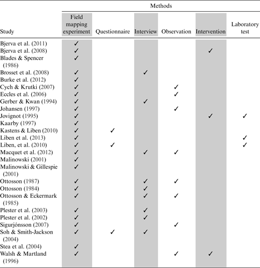
Table 1 summarises the methods used in 26 studies on wayfinding using maps and/or aerial photographs in large-scale, real-world settings.
Summary of methods used in each of the wayfinding studies that were reviewed for the present paper.

Both qualitative and quantitative studies are represented; the majority of studies are of a qualitative nature. Although experiments with human participants in the real world are time-consuming (Amedeo et al., Reference Amedeo, Golledge and Stimson2009), more quantitative research should be conducted. There are, for example, only three studies that have used questionnaires combined with field experiments. It is perhaps natural that studies are based on interviews and/or observations rather than questionnaires when the number of respondents is relatively few, but questionnaires in combination with standardised experiments in the field provide an opportunity to increase the number of informants and thus move towards more quantitative research. This would be an important contribution to research within this specific field of interest. Studies based on an intervention are also very limited but, for example, could be highly relevant in order to design more effective teaching programs (Wiegand, Reference Wiegand2006).
Only 3 of the 26 studies have combined experiments in the field with laboratory tests. This should be a focus of further research based on the disagreement about the extent to which laboratory-based findings might be replicated in real-world settings (Malinowski and Gillespie, Reference Malinowski and Gillespie2001; Montello et al., Reference Montello, Lovelace, Golledge and Self1999; Tlauka et al., Reference Tlauka, Williams and Williamson2008). Testing the same skill in the laboratory and in real-world settings will provide valuable input to this debate.
3.2. Measures
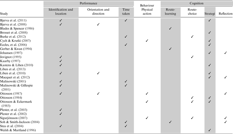
Table 2 summarises the measures used in 26 studies on wayfinding using maps and/or aerial photographs in large-scale, real-world settings.
Summary of the metrics used in each of the wayfinding studies that were reviewed for the present paper.
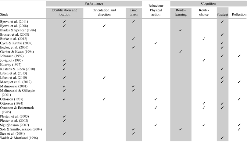
Most of the research has concentrated on measures of performance: letting participants find specific locations in the environment and/or finding specific locations on a map. Finding locations in the environment has been the most common, and includes specific landmarks, hidden objects or markers. In the competitive sport of orienteering, orange and white markers (called control flags) are used, and placed at specific landmarks in the environment. The participant confirms that the control points have been visited in the correct order by punching an electronic chip at a registration unit placed at the control point (Eccles et al., Reference Eccles, Walsh and Ingledew2002; Ottosson, Reference Ottosson1987). Most orienteering research (Blade and Spencer, Reference Blades and Spencer1994) has used similar designs to the competitive sport of orienteering. Finding a specific landmark is somehow different from finding markers or other items which are situated in the environment for the purpose of the research. Therefore, the use of markers can be a possible source of error because subjects can be tempted to randomly search out the markers, removing the focus from the map-reading. This is perhaps more applicable if the subjects are inexperienced adults or children. Some researchers have taken this into account and consciously omitted using markers in the terrain (Ottosson, Reference Ottosson1987; Sigurjónsson, Reference Sigurjónsson2007).
Measures of performance are generally associated with success or failure in finding specific locations, but some studies have also focused on orientation and directions (for example aligning a map) and also time used to find the locations. Time used to solve a wayfinding task can be interesting, not least in relation to age and sex. In this context it is useful to pay attention to the electronic timer system used in the competitive sport of orienteering. An electronic system provides options for looking more closely at various aspects of wayfinding, such as different wayfinding strategies. Orienteering research (Blades and Spencer, Reference Blades and Spencer1994) has benefited from this (Burke et al., Reference Burke, Kandler and Good2012), but it may also successfully be applied in other areas such as educational research (Blades and Spencer, Reference Blades and Spencer1994; Wiegand, Reference Wiegand2006).
Furthermore a few studies have observed participants’ physical behaviour either by ‘shadowing’ the participants in the terrain (Gerber and Kwan, Reference Gerber and Kwan1994; Ottosson, Reference Ottosson1987; Sigurjónsson, Reference Sigurjónsson2007) and/or using a head-mounted video camera (Eccles et al., Reference Eccles, Walsh and Ingledew2006; Macquet et al., Reference Macquet, Eccles and Barraux2012; Sigurjónsson, Reference Sigurjónsson2007). To ‘shadow’ a practitioner is familiar to coaches in the competitive sport of orienteering, but experimental procedures like these are time-consuming and require resources and close supervision (Amedeo et al., Reference Amedeo, Golledge and Stimson2009).
To investigate cognition in relation to wayfinding we find studies of route choice, route learning, strategies for wayfinding and reflections. Investigating strategies are most common in studies of cognition in wayfinding, but since the majority of studies involve experienced orienteers it could be interesting to move the focus towards children and inexperienced adults. A ‘think aloud’ technique to reveal the participant's reflections (reason for action) has also been used in a limited number of wayfinding studies (Eccles et al., Reference Eccles, Walsh and Ingledew2006; Johansen, Reference Johansen1997; Ottosson, Reference Ottosson1984; Walsh and Martland, Reference Walsh and Martland1996). This method employs the use of a microphone and instructing the participants to verbalise what they are thinking during the wayfinding. Talking loudly to oneself can be experienced as ‘unnatural’ and children may find it difficult to verbalise their thoughts. In spite of these challenges the ‘think aloud’ technique has been used also with children by recording the conversation between two children while they solved a wayfinding task together (Sigurjónsson, Reference Sigurjónsson2007).
3.3. Subjects, Context and Maps
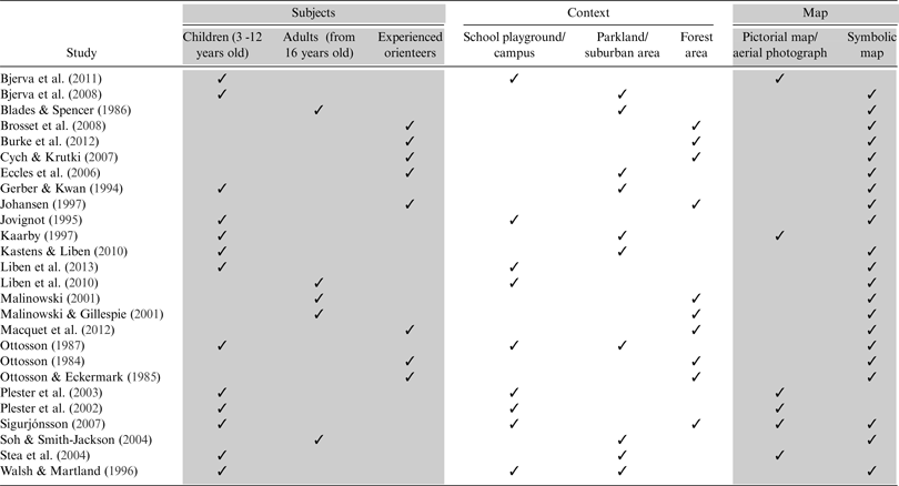
Table 3 summarises the subjects, context and maps used in 26 studies on wayfinding conducted in large-scale, real-world settings.
Summary of the subjects, context and maps used in each of the wayfinding studies that were reviewed for the present paper.
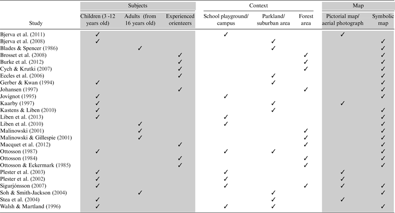
Subjects used in studies of wayfinding differ both in age and experience. Age is an interesting variable in wayfinding (Farr et al., Reference Farr, Kleinschmidt, Yarlagadda and Mengersen2012). Half of the 26 studies in the present review were conducted with children of different ages. This is slightly different to laboratory-based studies on wayfinding where adult subjects are most common (Blades and Spencer, Reference Blades and Spencer1994). Furthermore, most of the relevant studies were conducted on either inexperienced children or experienced adult orienteers. Research on wayfinding with inexperienced adults is very limited. Given that many adults are neither competent nor confident when using maps in the environment (Blades and Spencer, Reference Blades and Spencer1986; Reference Blades and Spencer1987; Gerber and Kwan, Reference Gerber and Kwan1994; Vaagbø, Reference Vaagbø1997; Wiegand, Reference Wiegand2006), this is a potential area for future research along with studies on children who are experienced with wayfinding.
One of the three processes of wayfinding is decision-making (Chen and Stanney, Reference Chen and Stanney1999), which, among others, is dependent on human elements. Gender is such a human element (Farr et al., Reference Farr, Kleinschmidt, Yarlagadda and Mengersen2012) where gender was shown to be a significant predictor of wayfinding performance by some researchers (Malinowski and Gillespie, Reference Malinowski and Gillespie2001). Most studies on wayfinding using maps in large-scale, real-world settings have a mixed sample of male and female genders, but very few have focused specifically on gender differences in wayfinding. Many laboratory-based studies have had this particular focus (Coluccia and Louse, Reference Coluccia and Louse2004). The interesting thing here is the extent to which results based on an ecological approach correlate with the large number of laboratory-based results that already exist showing that males outperform females in spatial tasks (Liben, Reference Liben, Renninger and Sigel2006; Wiegand, Reference Wiegand2006).
Wayfinding in unfamiliar environments requires external aids (Blades, Reference Blades, Foreman and Gillett1997), and therefore unfamiliar environments are most prevalent when wayfinding by the means of maps is investigated. The majority of studies however, have been conducted in familiar environments (Walsh and Martland, Reference Walsh and Martland1996) such as neighbouring areas which are usually adjacent to a school. These areas are often limited defined spaces with relatively few landmarks compared to forest areas. Apart from the research on experienced orienteers, there are two studies of novices conducted in forest areas; the study by Sigurjónsson (Reference Sigurjónsson2007), who observed children's wayfinding in both a school playground and a forest area, and the study by Malinowski and Gillespie (Reference Malinowski and Gillespie2001), who investigated students’ wayfinding in a forest area. The level of difficulty in a wayfinding task is closely related to the complexity of the context. We therefore agree with Malinowski and Gillespie (Reference Malinowski and Gillespie2001), who claim that there is a lack of research into real-world settings involving complex tasks. Future studies might therefore pay more attention to complex settings such as forest areas, first because little such research has been conducted hitherto, and secondly because investigating more complex tasks can reveal additional aspects of wayfinding.
In the early studies, the use of symbolic maps was most prevalent, but even symbolic maps can differ. A manipulated symbolic map, for example, where specific symbols or colours are removed, creates opportunities for innovative research designs such as Johansen's study (Reference Johansen1997) of cognition in orienteering. Nevertheless, successful wayfinding with the guidance of a symbolic map requires mastering symbols, and this is a difficult task (DeLoache et al., Reference DeLoache, Pierroutsakos and Uttal2003). Pictorial maps may also be successfully used in research with adults, preferably for those who are inexperienced in map-reading. There are also examples of studies which have used aerial photographs (Plester et al., Reference Plester, Richards, Blades and Spencer2002; Reference Plester, Blades and Spencer2003). There is a clear difference between a photograph and a map (Keates, Reference Keates1989), but photographs may be a suitable approach to enhance map-reading (Plester et al., Reference Plester, Blades and Spencer2003) especially in studies with children. The angle from which a map is viewed is also relevant in this context. A symbolic map is seen from above (vertical angle), while a pictorial map or an aerial photograph can be seen from either vertically or an oblique angle. There is a general perception that a pictorial map presented at an oblique angle is easier to interpret than when viewed vertically (Downs et al., Reference Downs, Liben and Daggs1988; Plester et al., Reference Plester, Richards, Blades and Spencer2002; Robison and Spodek, Reference Robison and Spodek1965; Sigurjónsson, Reference Sigurjónsson2007). Recent studies have predominantly used pictorial maps with an oblique angle.
Using maps for wayfinding involves the ability to relate the map to the environment it represents. This can be a particularly difficult task if the map and the environment are not aligned (Blades and Spencer, Reference Blades and Spencer1990; Vosmik and Presson, Reference Vosmik and Presson2004). A prerequisite for successful wayfinding is always to keep the map aligned, and those who are unable to obtain information about various features on the map often fail to align the map. Consequently, they have difficulty in determining their position on the map and in which direction they should move (Sigurjónsson, Reference Sigurjónsson2007). Misalignment can therefore be the reason why individuals do not succeed in their wayfinding (Fewings, Reference Fewings2001). On the other hand, a perfectly aligned map can be the reason for success even if the ability to read a map is limited. Children especially are likely to have difficulties with using a map if it is not accurately aligned with the environment (Blades and Spencer, Reference Blades and Spencer1990; Blaut, Reference Blaut1997; Vosmik and Presson, Reference Vosmik and Presson2004). But even maps intended for adults (for example maps in airports or shopping centres) are often pre-aligned to make them easier to understand (Fewings, Reference Fewings2001). Map alignment has been the main focus in only a few studies (Bjerva et al., Reference Bjerva, Solbakken and Sigurjónsson2008; Ottosson, Reference Ottosson1987; Sigurjónsson, Reference Sigurjónsson2007).
4. CONCLUSIONS
Research related to wayfinding using maps in large-scale, real-world settings is limited in number and scope. In spite of this, many different methods and measures of performance have been examined. Thus, few studies can be directly compared (Blades and Spencer, Reference Blades and Spencer1994; Coluccia and Louse, Reference Coluccia and Louse2004). Nevertheless, this critical review has sought to summarise how these studies have been conducted and, on this basis, provide some methodological input in relation to further research.
Regardless of methodological challenges, there is both a need for more quantitative studies to make assertions about entire populations alongside qualitative studies to obtain further knowledge about human behaviour and cognition in relation to wayfinding. The majority of previous studies are of an exploratory character, but regarding the limited amount of research overall, there is still a need for more such studies.
There are surprisingly few studies which have focused specifically on the link between laboratory-based findings and findings from experiments in real-world settings. Scientists disagree about the extent to which laboratory-based findings might be replicated in real-world settings (Malinowski and Gillespie, Reference Malinowski and Gillespie2001; Montello et al., Reference Montello, Lovelace, Golledge and Self1999; Tlauka et al., Reference Tlauka, Williams and Williamson2008), and testing the same skill in a laboratory and in real-world settings should be of special interest in future research. Use of interventions is another methodological issue that may be valuable in relation to further research. For example, in the quest to find the best way to teach wayfinding in schools, interventions may be a feasible approach.
Boys and girls, children and adults, experts and novices should be the subject of further investigations. In particular, research on experienced children and unexperienced adults is very limited. Another area of special interest is the context in which the experiment takes place. We have argued that future research would advantageously involve more complex settings such as forest areas (Malinowski and Gillespie, Reference Malinowski and Gillespie2001). Finally, the type of map appears to be an important determinant of performance (Sigurjónsson, Reference Sigurjónsson2007), and is therefore very central in investigating individuals in different life-stages and with varying experiences. If the subjects are experienced, a symbolic map is probably a good choice, but if the subjects are inexperienced, there are other types of maps and even photographs that can be more suitable. A map should be an appropriate tool, experienced as an aid and not a constraining factor for the completion of the task.
It is challenging to conduct research under controlled conditions in the real world, and a basic rule should be to avoid as many potential sources of error as possible. In this context, we have argued that the use of markers could be a possible source of error. Another potential source of error is alignment of map. Researchers should take into account both these factors when designing new experiments.
Wayfinding is an exceedingly common task in human everyday life, and maps can play a key role in wayfinding in unfamiliar environments. The ability to interpret map symbols and understand the relationship between the map and the environment is a very complex activity (Blades and Spencer, Reference Blades and Spencer1987; Keates, Reference Keates1996; Sigurjónsson, Reference Sigurjónsson2007). There is therefore a need for further research using an ecological approach based on different types of maps.
ACKNOWLEDGMENTS
The authors would like to acknowledge Professor Miranda Thurston for her helpful comments on an earlier draft of this paper. The reviewers are thanked for their comments which have improved the paper. This research received no specific grant from any funding agency, commercial or not-for-profit sectors.