


Introduction
Harbour archaeology remains a discipline in search of its object. Within this paradigm, approaching harbours from the shore, rather than from the sea, obscures their functioning and places undue emphasis on the importance of quays and moles (Arnaud Reference Arnaud and Scheid2025: 21–22; de Graauw Reference de Graauw2025). The ranking system proposed by Schörle (Reference Schörle, Robinson and Wilson2011), based on visible structures or basin size, is restrictive, as it overlooks the capacity of other areas within the harbour system. Scholars have largely neglected the vast water bodies beyond harbour moles. Yet, ships moored not only in the basin, which includes quays and jetties, but also in nearby bays and along open coastlines, where vessels could be beached (Votruba Reference Votruba2017). Together, these form a larger harbour system (Sanchez & Jézégou Reference Sanchez and Jézégou2016). Considering a harbour as a system invites a reassessment of the economic impact of maritime trade and thus a re-evaluation of how port capacity should be measured. The difficulty lies in producing comparable datasets (Keay Reference Keay and Chioffi2021: 67; Arnaud Reference Arnaud and Scheid2025). We propose that harbour capacity can only be meaningfully assessed by analysing integrated harbour systems—comprising basins, bays and auxiliary mooring zones—through a standardised, multi-variable method.
The SHIPs project (Ships Harbouring In Ports, 2023–2028) considers the harbour from the sea and contextualises it accordingly. It aims to identify the different components of harbour systems, determine their functions and develop methodological tools for their analysis. Integral to this consideration is a re-evaluation of harbour archaeology that must be treated as an independent subfield of study with its own methods and research agenda.
Standardised methods, demonstrable results
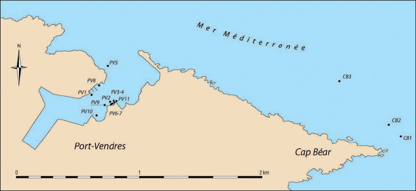
Fieldwork has helped refine a methodological framework that can be applied across contrasting contexts (submerged, silted, maritime and lacustrine). The framework produces comparable results despite differences in preservation and geomorphology. At Caesarea (Israel), where the harbour remains largely submerged, the system is shown to extend well beyond the Herodian basin, substantially increasing its estimated capacity (Ratzlaff Reference Ratzlaff2017). At Terracina (Italy), sedimentation is demonstrated to have progressively reshaped anchorage zones, challenging static reconstructions of the harbour landscape (Figure 1) (Di Rosa Reference Di Rosa, Urteaga and Pizzo2023). At Port-Vendres (France), the distribution of shipwrecks reveals a dense anchorage zone outside the formal harbour (Figure 2) (Castellvi Reference Castellvi2017). Similarly, at the Sea of Galilee (Israel), fluctuating water levels expose installations that refine estimates of usable harbour space in a lacustrine environment. Across these cases, the framework consistently shows that extra-basin anchorage zones play a decisive role in determining harbour capacity.
Terracina: simplified archaeological map of the stone-built basin (after Lugli Reference Lugli1926: pl. 2).

Port-Vendres: locations of shipwrecks and assemblages (produced with computer-aided design by M. Salvat/Association pour les Recherches Sous-Marines en Roussillon 2016).

Mooring techniques
Mooring practices are central to understanding the relationship between ships and harbour infrastructure. They are reconstructed through a combination of documentary and archaeological evidence, including preserved ropes, mooring rings and bollards and historical photographs of late nineteenth-century Greek sailing vessels. This integrated approach allows the reconstruction of mooring configurations and the assessment of key parameters, such as the mechanical properties of harbour installations. Excavation of the Byzantine jetty at Tiberias in the Sea of Galilee (Figure 3) provides further data on mortar performance in freshwater environments, confirming its continued use beyond the early Imperial period (late first century BCE–second century CE).
Tiberias: the Byzantine jetty during the 2025 excavation, looking east (photograph by E. Nantet).

Drafts and depths
Geomorphological studies in port areas provide valuable data for reconstructing coastal changes related to sedimentation and relative sea level changes and for determining the original depths of the various water bodies that form the harbour system (Figures 4 & 5). The reconstructed water column can be compared with the draughts of contemporaneous merchant vessels. Maintenance activities, such as dredging in the harbour basins, also affect water columns. Core sampling helps to identify clay layers that serve as indicators of the bottom of ancient harbour basins (Goiran et al. Reference Goiran and Preiser-Kapeller2022). While coring is feasible in a silted harbour such as Terracina, it becomes considerably more complex in eroded and submerged areas with mobile sandy substrates, such as at Caesarea.
Argelès-sur-Mer: coring campaign near the Tech River mouth in January 2026 (photograph by M. Audibert).

Kfar Aqavya: coring campaign in the Sea of Galilee (photograph by E. Nantet).

Basin and bay morphology
Our investigation aims to delineate harbour systems and clarify their functions. Lidar constitutes an excellent tool for large-scale preliminary surveys and is particularly well-suited to a project of this scope. However, as it cannot detect subsurface structures, its contribution remains limited. Other land-based remote-sensing techniques, such as ground penetrating radar, frequency domain electromagnetics and electrical resistivity tomography, have proven particularly effective for investigating selected key areas. These initial surveys have shown the importance of maintaining close collaboration between geophysicists and archaeologists in defining and refining the objectives of the investigation. They also demonstrate the need for a thorough preliminary reassessment of the archival documentation relating to each port, particularly cadastral and photographic records.
Mapping the water bodies
Existing documentation must be reviewed to map water bodies and identify mooring locations. An underwater operation enabled the identification of the precise location of the Port-Vendres 5 shipwreck and its poor state of preservation. Large-scale mapping was then undertaken to detect ship remains and associated assemblages, using marine geophysical surveys, which combined side-scan sonar, a sub-bottom profiler and a magnetometer (Figure 6). The anomalies identified through these surveys will subsequently be verified through targeted visual underwater inspections.
Port-Vendres: installation of the geophysical devices on the boat in September 2025 (photograph M. Lazar).

Conclusion
These four analytical axes provide a framework for estimating harbour capacity by correlating ship draught, mooring density and spatial extent, as demonstrated across Caesarea, Terracina and Port-Vendres, where extra-basin anchorage substantially alters capacity estimates. This approach offers a robust basis for the comparative evaluation of ancient harbour systems across diverse environmental contexts.
Funding statement
The project is subsidised by the European Research Council (CoG, SHIPs, 101088962). Views and opinions expressed are, however, those of the authors only and do not necessarily reflect those of the European Union or the European Research Council. Neither the European Union nor the granting authority can be held responsible for them.
Data availability statement
The data supporting this study are presented within the article. Additional data related to ongoing fieldwork and analysis are available from the authors upon reasonable request.



 Open access

