


Introduction
The early Christian centres of north-western Europe housed some of the era’s greatest thinkers, writers and theologians (e.g. Clancy & Márkus Reference Clancy and Márkus1995; O’Loughlin Reference O’Loughlin2007; Jenkins Reference Jenkins2010). Archaeological investigation of these establishments can provide invaluable insights into religious and intellectual life in North-west Europe as the post-Roman polities of western Europe took shape in the mid- to later first millennium AD. Yet, in Scotland, the research focus on these sites has been piecemeal or lacking (e.g. O’Sullivan Reference O’Sullivan1998).
From an archaeological perspective, the ecclesiastical centres of early medieval (c. AD 400–1100) Britain and Ireland comprise some of the period’s largest enclosed sites, with the Church a significant landholder according to documentary sources (e.g. Ó Carragáin Reference Ó Carragáin2021: 129). Often surrounded by vallum enclosures (usually a ditch and bank) defining the locus sanctissimus, early ecclesiastical sites included substantial church buildings, monuments such as a saint’s or founder’s tomb, places of burial, and representations of the cross (MacDonald Reference MacDonald and Carey2001: 29; Jenkins Reference Jenkins2010: 101; Ó Carragáin Reference Ó Carragáin2021: 135). While understanding of the character of some centres in Scotland has seen recent progress (e.g. Lowe Reference Lowe2008; Carver et al. Reference Carver2016; Campbell et al. Reference Campbell2019; Campbell & Maldonado Reference Campbell and Maldonado2020), many of the centres documented in historical sources are less well understood.
The monastery of Lios Mòr (Lismore) was an important ecclesiastical establishment on the island of the same name at the mouth of Loch Linnhe in Argyll, western Scotland (Figure 1). Its patron saint was Lugaid, known largely by his affectionate name-form Mo Luóc (literally ‘my little Lu(g)’, often now called Moluag). His death is recorded in the Irish chronicles by the line “Obitus Lugide Lis Moer” (The Annals of Ulster 592.1, Mac Airt & Mac Niocaill Reference Mac Airt and Mac Niocaill1983; also The Annals of Tigernach kl. 99, Stokes Reference Stokes1896, which adds “i. Moluóc”, “that is, Moluóc”, and Chronicum Scotorum 590.2, Hennessy Reference Hennessy1866) in annals corresponding to AD 593 or 594 (Evans Reference Evans2010: 240). Genealogies found in post-1100 manuscripts state that he was from the Dál nAraide (also called Cruithni) of north-east Ulster, and a twelfth-century source credits him with founding “no fewer than one hundred monasteries” (Ó Riain Reference Ó Riain2011: 494). As well as Mo Luóc, the deaths of succeeding abbots are recorded in the Irish chronicles: Neman, c. AD 614 (The Annals of Tigernach kl. 117.5) and Eochaid, c. AD 635–637 (The Annals of Ulster 635.7, The Annals of Tigernach kl. 138.4.4) but, with the establishment of Lismore Abbey in County Waterford, it is difficult to establish whether individuals were members of the Irish or Scottish monastery. Mo Luóc’s activities were part of a surge in monasticism that took place in the mid- to late sixth century in Celtic-speaking regions, which also included the foundation of Iona by Columba, around AD 563, and of St David’s in Wales and in Bangor, Clonmacnoise, Clonard and Clonfert in Ireland.
Map showing the maritime geography of Argyll (imagery from the NASA Worldview application (https://worldview.earthdata.nasa.gov/), part of the NASA Earth Science Data and Information System (ESDIS)).

By the late seventh century, Lios Mòr was part of Dál Riata, an early medieval Gaelic-speaking territory and kingdom that included Argyll and most of the Hebrides, spanning the Irish Sea to include part of County Antrim in Northern Ireland (Bannerman Reference Bannerman1974; Woolf Reference Woolf2007a; Fraser Reference Fraser2009). Dál Riata was crucial to the development of Scotland, with the kings of Alba (later Scotland) tracing their origin back to this western littoral territory. In the sixth to early eighth centuries, Dál Riata was a spiritual, cultural and sometimes political power-house, principally through its significance in the era’s developing early Christian networks, with a number of influential early Christian establishments located there, most famously Iona, but also Lismore, Applecross and St Blane’s, Bute (see Fraser Reference Fraser2009: 72–77, 103–106, 133–43 & 337–39) (Figure 1). Its impact was felt beyond the geographical boundaries of what became Scotland, extending deep into Ireland and northern England. Despite this, the archaeology of Dál Riata remains relatively unexplored and many of its early Christian landscapes are poorly understood (Campbell & Batey Reference Campbell and Batey2016: 8.3.6).
An island monastery: Lios Mòr
The regional significance of the island of Lismore and the monastery of Lios Mòr is suggested by the placename mór (‘big’), with lios (Old Gaelic les) common in Irish placenames, often denoting a secular enclosure. The use of lios is rare in Scotland, occurring in eastern and southern Scotland for a small number of places, often significant secular centres, and probably reflecting a Pictish or British word cognate with Welsh llys (‘court, manor house, hall’; Taylor & Márkus Reference Taylor and Márkus2012: 426–27). While its meaning in modern Scottish Gaelic is now primarily ‘garden’, detailed study of lios placenames in Ireland shows that it could relate to areas immediately around habitations and the notion of enclosure: “a settlement of one or more houses enclosed by a palisade, a rampart, or both” (Toner Reference Toner2000: 21–22; Taylor & Márkus Reference Taylor and Márkus2012: 426). Because Lios is primarily used for secular sites, pre-existing names were often adopted for monasteries (e.g. Dunkeld and Iona) and Lismore lies in a natural hollow, MacDonald (Reference MacDonald1974: 47–48) suggests that Lios Mòr was originally the name for a “perhaps pre-Christian, ceremonial and assembly site”. The local significance of this site is reflected in the use of the name not only for the monastery but for the island.
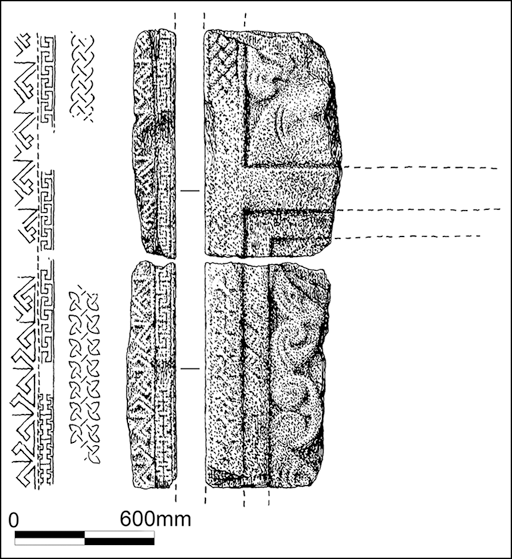
The location of Mo Luóc’s monastery has long been presumed to lie beneath the later medieval cathedral at Clachan. MacDonald (Reference MacDonald1974) hypothesised that the vallum monasterii of the early Christian site was identifiable in the current field boundaries around the parish church of Lios Mòr (Figure 2). Fragments of a cross-slab or cross-shaft from the churchyard were identified as early medieval (Fisher Reference Fisher2001: 121–22) (Figure 3) and three seventh- to eighth-century-style dress pins have also been found (MacDonald Reference MacDonald1974: 51–53), but the early medieval centre is otherwise unattested archaeologically. Excavations carried out in the mid-2000s identified only later medieval and post-medieval finds (Stoddart Reference Stoddart2005).
Lios Mòr, the Clachan with position of modern parish church, the cathedral ruins, the possible extent of the vallum based on MacDonald (Reference MacDonald1974), geophysical anomalies and survey areas and main trenching (figure by authors).

Previously identified early medieval cross fragments from Lios Mòr (Ian G Scott © Historic Environment Scotland).

Community-led investigations
A search for the site of Mo Luóc’s monastery was launched by the Lismore Historical Society in 2016. Archaeological investigations initially aimed to assess the preservation of the nave and associated structures of the medieval cathedral building, clarifying the results of excavations undertaken on the foundations in the 1950s (Brown & Duncan Reference Brown and Duncan1957). These confirmed the plan of the nave, the location of its southern entrance and the presence of a later tower at the western end. Dating of the mortar confirmed that the cathedral was built in the late thirteenth century (Thacker Reference Thacker2021: 44). Attention then turned to the possibility that the cathedral was built on the site of Mo Luóc’s monastery, which prompted wider investigation of the Glebe area and the potential vallum enclosure postulated by MacDonald (Reference MacDonald1974).
In 2019, excavations and geophysical surveys targeted some of the field boundaries (Figures 2 & 4). Possible enclosing features, potentially associated with the vallum boundary, were picked up on both resistivity and gradiometry (marked C & D on Figure 2), as were a series of possible enclosing walls/ditches to the east of the church (Figure 2). Excavation trenches 2, 6/8, 7 and 9 were opened by the modern field boundaries, revealing a turf bank and pebble path on the northern side of the boundary, and a limestone cobble surface associated with the lower course of a wall at two locations on the eastern boundary, but no secure dating material. Thus, there is little, as yet, to corroborate MacDonald’s suggestions; however, given the shallow limestone bedrock on Lismore, the vallum may have been constructed of a stone wall or a turf bank without a ditch. The course of the vallum may also have differed from the modern field boundaries, and the multiple linear features evident in the surveys should be prioritised for future investigation.
Aerial image of the 2019 excavations at Lios Mòr. Trench 11 containing the oval building and metalworking area is in the foreground (figure by authors).

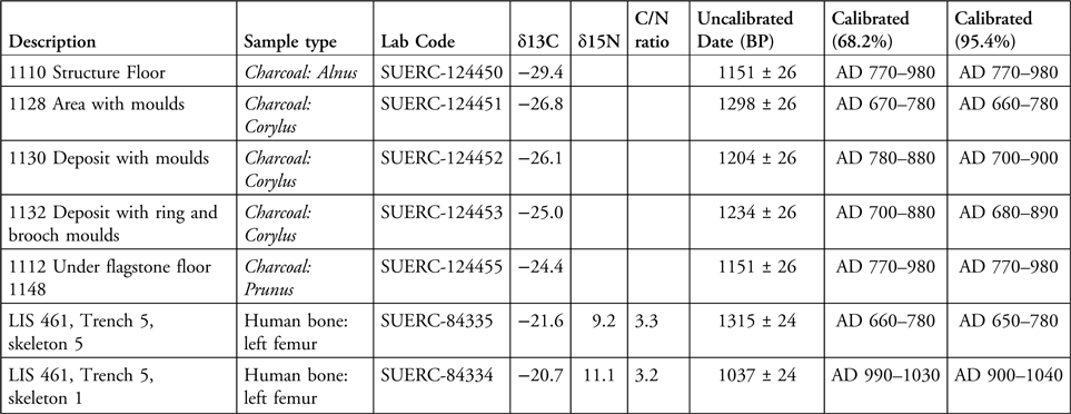
Human remains had been unearthed during the construction of a new church house to the south-east of the current parish church in the 1980s. The presence of a forgotten lower cemetery, only shown on an eighteenth-century plan of the glebe, was confirmed in 2018 (Trench T5; Figure 5). The uppermost layers of this trench contained a substantial number of disarticulated human bones that had been disturbed by later medieval metalworking in this area. Below this, in situ burials were broadly orientated east–west and exhibited much intercutting. At least six in situ burials, predominantly of adults, were located. Radiocarbon dates indicate that the earliest burial dates to cal AD 650–780 and the latest to cal AD 900–1040 (Table 1). A fragment of early medieval cross-slab was also found (Figure 6c), and the cemetery was enclosed by a clay-bonded limestone wall.
Trench 5 revealed early medieval graves contained within a limestone cemetery wall (figure by authors).

Radiocarbon dates from Lismore.

Newly identified early medieval sculpture fragments from Lios Mòr: a) fragment of cross-slab from T10; b) fragment of cross-slab with key pattern from T12; c) cross-slab fragment from T5 (figure by authors).

In 2021, trench T10 (Figure 7) was opened to the south of the church house, next to and incorporating the sanctuary stone, a broken granite cross. Again, large quantities of disarticulated human remains were found in the uppermost layers of the trench, together with later medieval artefacts, though a fragment of a decorated chlorite-schist cross-slab of probable seventh–eighth-century date was also recovered (Figure 6a). In the lower levels, burials were identified around the sanctuary stone and included infants, adolescents and adults. Initial assessment indicates that all the adult skeletons are male, with each exhibiting evidence of degenerative joint disease, while a small number of the juveniles and adolescents show evidence for infection and metabolic disease.
Trench 10 with further early medieval burials situated around the Sanctuary Stone (figure by authors).

This part of the cemetery seems to have been used repeatedly within the early medieval period, with disarticulated ‘bundles’ and spreads of bone located throughout the layers and within in situ burials. Grave cut 1025 contained an unusual combination of disarticulated bones, probably placed around a partially in situ burial. One femur recovered from this deposit (1026) showed sharp force trauma, possibly caused by a sword or axe. Two pairs of infant burials were also identified in this area (SK8 with SK9 & SK13 with SK14); each pair appears to have been placed within a single grave cut. The lower legs and feet of SK8 lay directly over the head of SK9. Some graves appear to have been stone-lined and capped. Further burials were identified to the north of the church house in T12, again enclosed by a limestone wall. A third fragment of a decorated early medieval cross-slab was found in this trench (Figure 6b).
As well as the early medieval burials and sculpture, the investigations also revealed early buildings and evidence for craft specialisation consistent with other high-status early Christian monasteries (and secular centres) of early medieval Britain and Ireland. The 2018 resistivity survey of the glebe lands identified two adjacent buildings. Subsequent excavation (T11) revealed an oval structure, around 8m in diameter, with a large drystone wall and a narrow west-facing entrance (Figures 2 & 8). The interior of the structure was paved with limestone slabs and a layer of charcoal located between the upper and lower paving may derive from the conflagration of an earlier structure. Only a few artefacts were recovered from the interior, including struck flint, handmade pottery, a possible metal punch, a crucible fragment and cut antler. Immediately east of the structure, consecutive charcoal-rich layers yielded hundreds of clay mould fragments, crucible sherds, carved pieces of wood and the occasional piece of flint, indicating an area of craft activity. Deposits associated with this oval structure returned dates from the eighth–tenth centuries AD (Table 1), while the craftworking layers were dated to the seventh–ninth centuries AD (Table 1). The entrance to the oval structure had been narrowed, perhaps for reuse as a stock enclosure, suggesting modification to the structure and its use through time. The rectangular building to the east of the oval structure was later than at least some of the metalworking deposits, but its date and character remain to be fully established.
Oval building and metalworking deposits in trench 11 (illustration of trench divided into two sections for visibility) (figure by authors).

More than 1000 fragments of non-ferrous metalworking debris, including well-preserved crucibles, crucible lids and fragments of moulds, were found in trench T11. Many of the crucibles are handled forms that are paralleled in the high-status metalworking assemblages from Dunadd (Argyll), Brough of Birsay (Orkney) and Portmahomack (Easter Ross) (Curle Reference Curle1982: 40–41; Lane & Campbell Reference Lane and Campbell2000: 135; Carver et al. Reference Carver2016: D77). The moulds are less well preserved but indicate that at least two types of penannular brooch were being cast at the site (Figure 9a) along with rectangular objects, possibly buckles. X-ray fluorescence analysis reveals that copper alloys were the main metals used, although a small number of crucibles show high levels of silver and gold, providing rare evidence of precious-metal casting. This evidence for gold-working may shed new light on an early medieval touchstone for testing gold that was found on Lismore in the nineteenth century and is now in the National Museums Scotland (Figure 9c).
Some finds from Lios Mòr: a) penannular brooch mould fragments from the 2019 excavations in T11; b) motif pieces with fine chip-carved designs from T11; c) an early medieval touchstone for testing gold, now held in the National Museums Scotland (images © National Museums Scotland).

Eight worked bone and antler objects were also found among the metalworking debris, including two fragments of mammalian long bones displaying exquisitely carved patterns (Figure 9b). These are examples of ‘motif pieces’, exhibiting very fine chip-carved interlace designs. Their function is not certain, but a role as practice pieces for metalwork designs or as formers for gold foil used to adorn decorative metalwork seems likely (O’Meadhra Reference O’Meadhra1987: 162; Craddock Reference Craddock and Youngs1990: 177). A long-bone fragment with a fine scroll carved into one end, possibly some sort of embossing tool for leather or sheet metal, and fragments of antler and bone offcuts attest to the manufacturing of such items on site.
Waterlogging in this part of the site created ideal conditions for the preservation of organic material, including bone, antler, horn and wood, providing glimpses of materials rarely found at other contemporaneous sites. Preliminary analysis of worked wood has identified yew hoops from stave-built vessels, along with the corner of a possible yew box and other offcuts, suggesting craftworkers were constructing such items in the workshop area. Other early medieval finds included household items, such as rotary quern fragments, cobble tools and a mortar, and more specialised craft tools like a large whetstone and pumice pebble. The whetstone’s size suggests it was used for sharpening sizeable blades (e.g. swords or sickles), while pumice could have been employed as an abrasive for preparing hides or fashioning wood or bone objects.
Discussion
The dates obtained thus far suggest that early medieval features at this site are extensive and include sculpture, cemetery deposits, high-quality craft-working and buildings. The finds strengthen the notion that the parish church is located on the site where Mo Luóc established a church in the sixth century. The early church, about which the early cemetery may have been focused, has not yet been identified, but the most likely location is on the drier ground to the west under the parish church graveyard. The project’s ambition to explore whether Lismore could be added to the small corpus of excavated early Christian ecclesiastical sites in Scotland—which includes Iona (Barber Reference Barber1981; O’Sullivan Reference O’Sullivan1998; Campbell & Maldonado Reference Campbell and Maldonado2020), Portmahomack (Carver Reference Carver2008; Carver et al. Reference Carver2016), St Blane’s (Laing et al. Reference Laing1998), Inchmarnock (Lowe Reference Lowe2008), the Isle of May (James & Yeoman Reference James and Yeoman2008) and Auldhame (Crone & Hindmarch Reference Crone and Hindmarch2016)—thus seems to be at least partly realised, albeit with much still to do.
The area around the present church house appears to comprise an enclosed cemetery dating from at least the seventh century AD, though earlier burials may exist in other parts of the Glebe. The upper cemetery around the church itself remains to be investigated and is likely to have also been used in the early medieval period. The new evidence from Lismore shows that skilled craftworkers were working at the site in the seventh to ninth centuries AD; the assemblage of non-ferrous moulds and crucibles is the largest yet found, after Dunadd (Lane & Campbell Reference Lane and Campbell2000). This activity was presumably being carried out within the monastic enclosure, though there may have been a secular influence or even presence given the production of items like brooches. In Ireland there was monastic production of secular items for trade and evidence for economic interaction between elite secular and ecclesiastical centres is clear (e.g. Stevens Reference Stevens2017: 258). Further research and excavation to contextualise the metalworking evidence on Lismore is needed. Insular church sites are thought to have been craft centres, and in some cases we know that the monks themselves were the producers (e.g. Gameson Reference Gameson2013: 25; Campbell et al. Reference Campbell2019: 328). Yet direct evidence of craft production at major monastic sites is relatively scarce. On Iona, small numbers of objects, including moulds for inlaid glass studs, rings and rods, and the finished objects themselves, suggest metalworking in various locations (Campbell et al. Reference Campbell2019: 302). A much larger assemblage is known from Portmahomack, Easter Ross, where metalworking in Period 2 (eighth century) included the crafting of both personal objects and fittings in metal and glass, some of which may have been from ecclesiastical metalwork (Carver et al. Reference Carver2016: 220–1, Digest 6.6, 6.7).
The Lismore evidence is a valuable new assemblage of craftworking from this period with many unique finds. No other motif pieces of the quality found at Lismore are known from Scotland and only a few have been found in Ireland (Craddock Reference Craddock and Youngs1990: 174–79). The Irish examples include finds from royal settlements at Lagore and Moynagh Lough (both County Meath). Crafting in yew is similarly difficult to parallel in Scotland, but again finds are known from early medieval Ireland, where early texts suggest yew workers held high status, and their products were highly prized (Kelly Reference Kelly1988: 61). Finally, while the early medieval sculptural assemblage from Lismore is relatively modest compared to the stone sculpture from other major centres such as Iona (Forsyth & Maldonado Reference Forsyth and Maldonado2012), the new finds show the potential of the site to reveal more high-quality sculptural evidence with further investigation. The three fragments of decorative carved-stone cross-slab found during excavations (Figure 6) include forms of ornament not previously seen in early medieval Scotland, along with highly accomplished key patterns unique to cross-slabs found further north in the Applecross and Easter Ross areas, at sites such as Nigg and Rosemarkie, possibly suggesting they were created by that same school of virtuoso stone carvers (Cynthia Thickpenny pers. comm. 2021).
Much remains to be explored in the ecclesiastical landscape of Lios Mòr. The presence and position of any surviving monastic vallum will be key in future investigations to define the devotional and sacred topography of this landscape. The topographical position of Lios Mòr provides a natural amphitheatre, with the bounds of the vallum postulated by MacDonald (Reference MacDonald1974: 53) lying within this nested topography. Vallum boundaries had a legal role in marking zones of sanctuary, and they may have also had practical and defensive roles in dissuading raiding or theft and defining areas of work, animal husbandry and industry (Picard Reference Picard, De Rubeis and Marazzi2008: 70; Jenkins Reference Jenkins2010: 101; Johnson Reference Johnson2013: 14; Cramp Reference Cramp, Thomas and Knox2017: 30). Charting the size and shape of any vallum enclosure will be important—elsewhere in Britain and Ireland the size of vallum enclosures tends to correlate with the importance of particular church sites (O’Sullivan et al. Reference O’Sullivan2014: 147), and distinctions in shape between major and minor sites and between those in Scotland and Ireland are observed (Campbell & Maldonado Reference Campbell and Maldonado2020: 58–63). Geophysical survey, particularly resistivity, gives hope here as multiple potential boundaries have already been detected (Figure 2). Testing and dating these potential boundaries will also be important, though the arable richness of Lismore may mean that early boundaries were at least partially erased—particularly if the boundaries were defined by walls, hedges or wattle fences rather than ditches and banks (e.g. Petts Reference Petts, Lucy and Reynolds2002: 29; Reference Petts, Thomas and Knox2017: 49).
The question of contemporaneous early medieval sites on the island also awaits further exploration. Small-scale excavations around the entrance to Tirefour broch in 2005 recovered a spectacular seventh–eighth-centuries decorated copper-alloy stick pin, which might suggest high-status early medieval reuse of this substantial broch settlement (Campbell in Stoddart Reference Stoddart2005). The wider context of Lios Mòr must also be considered. The land defined by any vallum boundaries may have been but a small part of an ecclesiastical estate that is likely to have included extensive and diverse portions of outlying land (Ó Carragáin Reference Ó Carragáin2021: 135). Work looking at the potential wider landholding of Lios Mòr on the island (and perhaps beyond) could begin with wider mapping of potential early church sites, and exploring parallels for the carved stone monuments and artefacts found during the excavations. With regards to landholding, church lands may have extended beyond the island to the nearby coastal district known as Appin ‘abbey lands’ (Watson Reference Watson1926: 124).
Christian sites were dedicated to Mo Luóc in many places beyond Lismore, including in Argyll and the Outer Hebrides (Watson Reference Watson1926: 292–3; MacIlleDhuibh Reference MacIlleDhuibh2006: 191, 193) and further east (Watson Reference Watson1926: 293) at prominent sites such as Mortlach in Banffshire, a precursor to Aberdeen as an episcopal see, and at Rosemarkie on the Black Isle, one of the most important churches in Pictland, where the Aberdeen Breviary suggests that Mo Luóc was buried (Dransart Reference Dransart and Cartwright2003; Woolf Reference Woolf, Arbuthnot and Hollo2007b). Two likely dedications in Ireland are also known (Ó Riain Reference Ó Riain2011: 494). These placenames and dedications attest to a widespread devotion to Mo Luóc before the Reformation. His appearance in martyrologies, which detail the saints venerated on each day of the year, shows that Mo Luóc was not only known in Ireland, but also was regarded as significant enough to be added to these texts in the early eleventh century in places on the continent where Gaels were active, such as Metz in Lorraine and Regensburg in Bavaria (Ó Riain Reference Ó Riain2006: 61, 138, 238). A ‘life’ of Mo Luóc is also likely to have existed in the twelfth century, but is now lost (Grosjean Reference Grosjean and Battiscombe1956; Clancy Reference Clancy and Cartwright2003: 225–26).
Looking at the wider context, the island of Lismore lies at the mouth of Loch Linnhe, which leads to the Great Glen, a major strategic routeway, giving access and allowing control across the Scottish Highlands (Figure 1). To the south of the island, the nucleated fort of Dunollie is repeatedly mentioned in Irish chronicle accounts. The exact political situation of Lios Mòr at the time of its foundation is uncertain, but by the early eighth century it is clear that Lismore was located amidst Cenél Loairn territory surrounding Loch Linnhe, and may have had a close relationship with this kingdom during the period AD 690–740 when Cenél Loairn were often successful in becoming over-kings of Dál Riata (Fraser Reference Fraser2009: 242–52, 282–85, 293–305). While Dunadd has come to be seen as the pre-eminent centre of Cenél Loairn, Dunollie is the most referenced early medieval fortified centre in the Irish chronicles, being mentioned five times in the Annals of Ulster between AD 685 and 734 (see Noble et al. Reference Noble2022: tab. 3). In this respect, the juxtaposition between Dunollie and the church and island of Lismore is intriguing. The area around Dunollie and Lismore is likely to have been one of the most, if not the most, economically productive in Argyll (Figure 10). The Reverend Gregor McGregor in the New Statistical Account of Scotland described Lismore as “like a garden in a desert” (Gordon Reference Gordon1845: 224), and in recent centuries the island was known for both its arable and pastoral potential—McGregor suggests that no district in Argyll was better at rearing cattle due to the richness of its grass (see also Sinclair Reference Sinclair1791: 483). Lismore was also known for the accessibility of high-quality marine and freshwater resources.
Approximate extent of Dal Riata with agricultural potential mapped based on Macauley Land Capability Classification for Agriculture (1991). Graphics encompass Macauley classes 1–5, including land suitable for grazing but not for extensive arable farming. Most agricultural potential in Argyll is in this category. The range of variability in each 8km hex is the percentage of the hex that is agricultural land. The highest percentage depicted is 79%. Data provided by The James Hutton Institute under its Open Data Licence (https://www.hutton.ac.uk/land-capability-for-agriculture-lca/) (figure by authors).

While not doubting the importance of Iona, it has been pointed out that Iona leaned towards the rival group Cenél nGabráin rather than Cenél Loairn, with Adomnán’s Life of Columba conspicuously quiet about the latter group (Fraser Reference Fraser2009: 143–44, 250–52). This, and the success of Iona in spreading the cult of Columba may have overshadowed the importance of other Dál Riatan Christian centres. In fact, it may be that other early Christian churches competed with Iona to be the pre-eminent Christian centre of Dál Riata and are overlooked due to the nature of our surviving sources, which emphasise the role and standing of Iona (Fraser Reference Fraser2009: 105–106, 250, 336–38). Indeed, fragmentary early medieval references, Mo Luóc’s widespread cult, the agricultural richness of Lismore and environs (Figure 10), and the fact that Lismore became the seat of the later medieval bishops of Argyll (MacDonald Reference MacDonald2013) together suggest that Lismore was, and became increasingly through time, a major centre in its own right. Overall, we might expect that a complex and fluid picture of dynastic and ecclesiastical prominence characterised the early medieval period in the west of Scotland, one perhaps not captured in surviving written sources. Through archaeology, we can begin to map the early Christian centres within this landscape in more detail and examine their perhaps fluctuating fortunes.
Conclusions
Archaeological investigations at Lios Mòr have revealed extensive early medieval cemetery deposits, high-status craftworking evidence and early structural remains suggesting that the site was a major ecclesiastical centre, presumably the site founded by Mo Luóc in the sixth century. While direct evidence from this date remains elusive, the material culture and burial practices from the seventh to tenth centuries AD reflect a thriving monastic community with regional and possibly supra-regional influence. The presence of precious metalworking, motif pieces and yew woodcraft suggests a centre of considerable wealth and artistic sophistication, paralleling other major Insular monastic sites such as Iona and Portmahomack.
The finds also highlight the overlooked strategic and economic importance of Lismore, particularly in relation to nearby power centres like Dunollie, and its significance at the heart of Cenél Loairn, one of the kindreds competing for supremacy in Dál Riata. The interplay between ecclesiastical and secular authority in this region may have been more dynamic and competitive than previously understood. Moreover, widespread dedications to Mo Luóc across Scotland and Ireland underscore the saint’s enduring spiritual legacy and the influence of him and his followers. Future research should focus on delineating the full extent of the monastic enclosure, exploring the upper cemetery and mapping the broader ecclesiastical estate. These efforts will not only refine our understanding of Lismore’s sacred landscape but also contribute to a more nuanced picture of early Christian networks in Insular Britain and Ireland.
Acknowledgements
We warmly acknowledge the community of Lismore and all those who supported our crowd funding. Full analysis of the waterlogged wood assemblage is being carried out by Anne Crone and Genoveva Dimova of AOC Archaeology. Carly McNamara and Cynthia Thickpenny are analysing the sculptured stone fragments for full publication.
Funding statement
This research was funded by Lismore Gaelic Heritage Centre (bequest Hugh MacPherson), the Society of Antiquaries of Scotland, Lismore Historical Society, the MacDougall McCallum Foundation (USA); the Leverhulme Trust; the Hunter Trust; the MacDougall Clan Society of America and several individual donors. The writing of the article was supported by a Leverhulme Trust Research Leadership Award (RL-2016-069).
Author contributions: CRediT categories
Clare Ellis: Conceptualization-Equal, Investigation-Equal, Methodology-Equal, Writing - original draft-Equal, Writing - review & editing-Equal. Angela Boyle: Writing - review & editing-Supporting. Gemma Cruickshanks: Data curation-Equal, Formal analysis-Equal, Funding acquisition-Equal, Writing - original draft-Supporting, Writing - review & editing-Supporting. Nicholas Evans: Conceptualization-Equal, Investigation-Equal, Methodology-Equal, Writing - original draft-Equal, Writing - review & editing-Equal. Robert Hay: Funding acquisition-Equal, Resources-Equal, Writing - review & editing-Supporting. Edouard Masson-MacLean: Conceptualization-Equal, Investigation-Equal, Methodology-Equal, Writing - original draft-Equal, Writing - review & editing-Equal. Joshua Wright: Writing - review & editing-Supporting. Gordon Noble: Conceptualization-Lead, Formal analysis-Lead, Funding acquisition-Supporting, Investigation-Supporting, Methodology-Lead, Resources-Equal, Writing - original draft-Lead, Writing - review & editing-Lead.






 Open access

