





Introduction
In recent years, climate change has contributed to the increasing frequency and severity of some natural hazards that may result in mass-casualty incidents (MCIs), Reference Seneviratne, Zhang and Adnan1 while battles and conflicts have also risen markedly. Reference Jenkins, Willis and Han2,Reference Kattelman3 Although the causes of MCIs vary widely, their common feature is the disruption of normal health care operations and a sudden surge in the need for Emergency Medical Services. Reference Lomaglio, Ansaloni, Catena, Sartelli, Coccolini, Kluger and Catena4,Reference O’Donnell, Lardaro, Liao, Cone and Delbridge5 Effective management of this chaotic environment requires field teams’ rapid access to the scene and uninterrupted information collection, analysis, and transmission. Reference Lowes and Cosgrove6 However, as seen in the Las Vegas shooting (Las Vegas, Nevada USA; 2017) and the Boston Marathon bombing (Boston, Massachusetts USA; 2013), security threats may delay response teams’ entry to the scene. Reference Gates, Arabian and Biddinger7,Reference Ugwu and In Las Vegas8 Past experiences also show that failures in communication with the scene have caused increased mortality, Reference Sloan9–12 prolonged evacuation times, Reference Sloan9 hospital over-crowding, and delays in hospital preparedness. Reference Ozoilo, Pam, Yiltok, Ramyil and Nwadiaro13 For these reasons, real-time data transmission and scene monitoring are considered essential components of medical management in MCIs. Reference Ahmad14 Another fundamental component of this medical response process is on-scene triage. Reference Nordling15
In an MCI, the first step in medical care at the scene is triage. There are numerous triage algorithms developed for MCIs. Reference Bazyar, Farrokhi and Khankeh16 However, the scientific evidence supporting the use of these algorithms remains limited. Reference Gaul17 Additionally, large numbers of casualties, the scale and complexity of the incident scene, and security concerns can significantly hinder response teams’ ability to follow established triage protocols. Reference Ozoilo, Pam, Yiltok, Ramyil and Nwadiaro13,Reference Ryan, George, Liu, Mitchell, Nelson and Kue18 In recent years, the use of unmanned aerial vehicles (UAVs), commonly known as drones, to address these problems has increased.
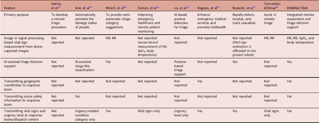
For more than a decade, UAVs have been widely used in MCIs for purposes such as scanning sites, enhancing situational awareness, and transmitting imagery. Reference Daud, Yusof and Heo19 With the development of image-processing techniques that enable vital signs to be assessed remotely, the use of UAVs has further expanded, providing new potential for MCI triage. Reference Mösch, Pokee and Barz20,Reference Pająk, Przybyło and Augustyniak21 Garcia and colleagues developed a drone-based triage model relying on visual inspection of drone-captured imagery. Reference Álvarez-García, Cámara-Anguita and López-Hens22 Mösch, et al reported a triage system based on processing drone imagery to extract pulse and respiratory rate (RR). Reference Mösch, Pokee and Barz20 In a study by Lu, et al, a drone-based system integrated with artificial intelligence (AI) successfully detected casualties’ body posture to inform triage decisions. Reference Lu, Wang and Chen23 Table 1 presents a schematic comparison of the “Drone-Integrated, AI-Based Mass-Casualty Triage Decision Support System” (DIABMaCTDeS) with previously published drone-based triage systems. Reference Arai, Iwata, Hara and Satoh24–Reference Tuncarslan and Yilmaz28
Comparison of DIABMaCTDeS with Previously Published Drone-Based Triage Systems

Table 1. Long description
The table compares different drone-based triage systems across several features. It has 8 columns and 7 rows, including the header row. The columns are labeled: Feature, Garcia, et al, Arai, et al, Msch, et al, Furkan, et al, Lu, et al, Nagayo, et al, Rusiecki, et al, Tuncarslan &Yilmaz, DIABMaCTDeS. The rows list various features and their corresponding values across the different systems. Row 1: Primary purpose, To develop a remote triage procedure, Automatically estimate the damage status of people, To provide semi-automatic triage category suggestions, Improving emergency healthcare and remote patient monitoring, AI-based posture detection for triage, Enhance emergency medical services and promote telehealth, Rapidly detect, localize, and track casualties, Assist in remote triage, Integrated remote assessment and triage decision support. Row 2: Image or signal processing-based vital-sign measurement from drone-captured images, Not reported, Not reported, HR, RR, Not reported (sensor-based measurement of HR, SpO2, body temperature), Not reported, Not reported (vital-sign estimation is offloaded to the ground robots), HR, RR, HR, RR, SpO2, and body temperature. Row 3: AI-assisted triage decision support, Not reported, AI-assisted triage-like classification, Yes, Not reported, Posture-based triage support, Not reported, Yes, Not reported, Yes. Row 4: Transmitting geographic coordinates to response team, Not reported, Not reported, Not reported, Not reported, Not reported, Yes, Not reported, Not reported, Yes. Row 5: Transmitting scene safety information to response team, Not reported, Yes, Not reported, Not reported, Not reported, Not reported, Not reported, Not reported, Yes. Row 6: Transmitting vital signs and urgency level to response teams/dispatch centers, Not reported, Urgency level only, Yes, Vital signs only, Urgency level only, Yes, Yes, Vital signs only, Yes.
Abbreviations: DIABMaCTDeS, Drone-Integrated, AI-Based Mass-Casualty Triage Decision Support System; HR, heart rate; RR, respiratory rate; SpO2, oxygen saturation.
Although drone-based triage is developing rapidly, to the best of the authors’ knowledge, no existing system integrates image-and signal-processing-based vital-sign measurement, AI-assisted triage decision support, real-time casualty location data, and scene safety information within a single platform and transmits all these data to both dispatch centers and response teams. This study aimed to present the DIABMaCTDeS and its multi-module platform designed for remote triage and monitoring.
Methods
The developed system is a multi-component remote triage and monitoring system that enables rapid and comprehensive scene assessment in MCIs using a drone; measurement of vital signs through image processing; determination of casualty urgency levels based on an AI-driven decision process; and near real-time transmission of data on scene safety issues, medical status, and victims’ locations to dispatch centers and on-site response teams. The system consists of the following core modules.
Vital-Sign Measurement Module
In the system, fundamental physiological parameters, including respiratory rate (RR), heart rate (HR), oxygen saturation (SpO2), and body temperature (BT), are estimated entirely through contactless methods using RGB (red, green, blue) and infrared imagery captured by a drone. Detailed descriptions of the image-processing pipelines, algorithm development, and model architectures are presented in a separate study Reference Tayfur, Şimşek and Akgül29 and are briefly summarized here.
-
• Heart Rate Measurement Algorithm: The video-based photoplethysmography (vPPG) method was used to develop the HR measurement algorithm. The forehead was selected as the region of interest (ROI) using the Viola–Jones algorithm for face detection, and the RGB color values of this region were extracted from each video frame. An adaptive bandpass filter was applied to optimize the signal by reducing noise and artifacts. Subsequently, time-dependent frequency analysis was performed using the Short-Time Fourier Transform (STFT), and the HR frequency was calculated.
-
• Oxygen Saturation Measurement Algorithm: Oxygen saturation was measured from facial infrared images captured by the infrared camera. The forehead and cheek regions were selected as the ROIs, and face detection and tracking were performed using the Viola–Jones algorithm and OpenCV (Open-Source Vision Foundation; Palo Alto, California USA). The image signals were enhanced using Eulerian video magnification refers to an image-processing method described by Wu et al, Reference Wu, Rubinstein, Shih, Guttag, Durand and Freeman53 not to a product or software developed by Eulerian Technologies. A regression-based neural network approach was adopted for SpO2 estimation.
-
• Respiratory Rate Measurement Algorithm: The RR was determined based on the analysis of temperature changes around the nose region using thermal images. The nostril region was automatically detected using OpenCV, and the mean temperature of this region was tracked over time across successive video frames. The resulting signal was filtered using a digital Butterworth filter to reduce noise, and the RR per minute was calculated by analyzing the signal peaks.
-
• Body Temperature Measurement Algorithm: The face was selected as the ROI for BT measurement. Face detection was performed using the Haar cascade classifier (OpenCV). Infrared images were used and converted to grayscale to calculate the normalized temperature distribution. The images were then transformed into temperature maps, and regions with temperatures above 28°C were thresholded to identify potential BT areas. Contour detection was applied to the thresholded regions to calculate their mean temperatures, and these regions were validated using the Intersection over Union (IoU) metric to determine whether they corresponded to the face. Finally, regions with a high overlap with the detected face were considered valid for BT estimation.
Triage Decision Support Module
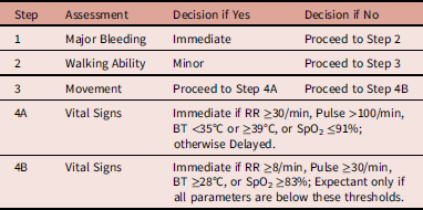
An AI-assisted Decision-Support System (DSS) for triage was developed using a dataset derived from anonymized trauma patient records. Class imbalance in the dataset was addressed using the ADASYN (Adaptive Synthetic Sampling) method, and the data were split chronologically into training, validation, and test subsets. Logistic Regression, Support Vector Machine, Deep Neural Network, and Random Forest models were trained and compared under the same protocol. Among these models, the Random Forest classifier demonstrated the highest accuracy and the best class balance. Using scikit-learn (NumFocus; Austin, Texas USA), sensitivity and specificity values were calculated as 0.92 and 1.00, respectively, on the imbalanced dataset, and as 0.97 and 0.93 on the balanced dataset. Based on this performance, the Random Forest algorithm was integrated as the triage decision engine of the DSS. The Drone-Integrated Mass-Casualty Triage Algorithm (DIMaCTA), created for this project, is used for triage assignment. The Random Forest model integrated into the DSS was trained using triage labels generated according to the DIMaCTA. Detailed information on the development of the algorithm has been published previously, Reference Tayfur, Gündüz and Şimşek30 and a summary of the DIMaCTA triage algorithm is presented in Table 2.
Summary of DIMaCTA Triage Algorithm

Table 2. Long description
A table titled ‘Summary of DIMaCTA Triage Algorithm’ with four rows and three columns. The columns are labeled ‘Step’, ‘Assessment’, ‘Decision if Yes’, and ‘Decision if No’. The rows detail the triage process: Step 1 assesses for Major Bleeding, with immediate action if yes and proceeding to Step 2 if no. Step 2 evaluates Walking Ability, with minor intervention if yes and proceeding to Step 3 if no. Step 3 checks for Movement, proceeding to Step 4A if yes and to Step 4B if no. Step 4A and 4B both assess Vital Signs with specific thresholds for immediate action or expectant management.
Note: The algorithm is described in detail in Tayfur, et al. Reference Tayfur, Gündüz and Şimşek30
Abbreviations: DIMaCTA, drone-integrated mass-casualty triage algorithm; RR, respiratory rate; BT, body temperature; SpO2, oxygen saturation.
The DSS receives vital sign measurements generated by the Image Processing module. In addition, the drone control station officer enters observable victim characteristics (walking, movement, bleeding) into the system. These inputs are then processed by the trained Random Forest model within the DSS to assign the appropriate DIMaCTA triage category. The resulting triage decision is then transmitted to the user interface and dispatch centers in near real time.
User Interfaces and Data Transmission Module
Integrated user applications were developed to transmit vital signs measured through image processing, the assigned triage category, casualty coordinates, and scene safety information to the dispatch center and field teams. Based on the requirements analysis, three separate software interfaces were designed for users at the drone control station (DCS), dispatch center personnel, and field responders. These interfaces incorporate the WebSocket protocol for real-time data transmission and include functions such as system parameter settings, scene mapping, and visual data management.
Operational Mechanism of DIABMaCTDeS
The system’s operation consists of the following three stages (Figure 1):
-
(1) System Activation: The system is activated by dispatch centers when an MCI occurs. Following the incident notification, the activation process begins with the launch of the UAV/drone from either the dispatch center or the DCS.
-
(2) Data Collection and Transmission: The drone first conducts a reconnaissance flight at the scene to detect security threats. Then, it approaches the victims and obtains images of the victims. These images are transmitted to the DCS and processed at the station. As a result of the processing of the images, vital signs are measured. Based on these measurements, the triage categories are determined. Then, information about the security, the locations of the victims, and their triage categories are transferred to the dispatch center. The dispatch center directs the necessary number of medical teams equipped with appropriate resources to the scene. Response teams are informed in advance of the on-scene security conditions and casualty urgency levels before arriving.
-
(3) Intervention by Medical Teams: First responders can access the system via mobile devices such as tablets or smartphones to view the triage code assigned to each casualty. They may confirm this code or update it based on their clinical assessment. As long as casualties remain at the scene, the system can continue monitoring casualties and provide updated triage recommendations for review by health care professionals.
General Overview of DIABMaCTDeS.
Note: The operational workflow of DIABMaCTDeS consists of four sequential stages. (I) The drone captures images from the incident scene and transmits them to the Drone Control Station (DCS). (II) At the DCS, DIABMaCTDeS analyzes the images to extract victim location and vital signs, while the DCS officer enters scene safety information and observable triage-related findings into the system. (III) The processed information is transmitted to the Emergency Operations Center (EOC), enabling dispatch of appropriately equipped response teams. (IV) The most urgent casualties are prioritized for evacuation. (V) Triage categories are confirmed or updated by medical teams. Abbreviations: DIABMaCTDeS, Drone-Integrated, AI-Based Mass-Casualty Triage Decision Support System; DCS, Drone Control Station; DIMaCTA, drone-integrated mass-casualty triage algorithm; EOC, Emergency Operations Center.

Pilot Evaluation of the Vital-Sign Measurement Module
The performance of the image-processing-based vital-sign measurement algorithms embedded in DIABMaCTDeS was evaluated in a pilot study. During this stage, vital sign measurements were performed indoors under stable lighting conditions. Participants sat at a distance of 180 cm from the camera and remained stationary while their vital signs (HR, RR, and SpO2) were simultaneously measured with a patient monitor. Also, BT was measured using a clinical thermometer. Videos were captured using a DJI Zenmuse H20T drone camera (DJI Technology Co., Ltd.; Shenzhen, Guangdong, China) with a video resolution of 4K at 30fps. The pilot evaluation was intended to provide initial proof-of-concept evidence for the module rather than establish clinical equivalence with standard medical devices. Mean Squared Error (MSE), Root Mean Squared Error (RMSE), and Mean Absolute Error (MAE) were calculated to evaluate the performance of the image-processing-based vital-sign measurement algorithms. Statistical analyses were performed using Microsoft Excel (Microsoft Corp.; Redmond, Washington, USA) and IBM SPSS Statistics version 27 (IBM Corp.; Armonk, New York, USA). Error rate (%) and relative measurement accuracy rate (%) were calculated using the following formulae:


Ethical Approval
The study adhered to the Declaration of Helsinki and was approved by the Hamidiye Scientific Research Ethics Committee of the University of Health Sciences (Istanbul, Türkiye; Decision No. 2/27). Written informed consent was obtained from all volunteers.
Results
Technical Characteristics of the System
The developed system enables measuring RR, HR, SpO2, and BT without physical contact by integrating vPPG, thermal fluctuation analysis, and regression-based neural network approach applied to RGB and thermal images captured by the drone. The system collects the extracted vital signs, the triage classification generated by the decision support module, casualty location data, and scene safety information into a single data stream and transmits it in near real time to the dispatch center and response teams. User interfaces allow operational units to stay informed about on-scene safety and monitor both the urgency level and geographic location of the victims simultaneously.
Pilot Evaluation of the Vital-Sign Measurement Algorithms
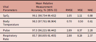
To provide an initial technical evaluation of the contactless vital-sign measurement module integrated into the proposed system, a small-scale pilot study was conducted using 15 healthy volunteers (86.7% male; mean age 32.9 [SD = 6.7] years). The mean accuracy rates and other performance metrics of the vital-sign measurement algorithms are presented in Table 3.
Performance Indicators for Algorithms Estimating Vital Signs from Images

Table 3. Long description
A table titled Performance Indicators for Algorithms Estimating Vital Signs from Images. The table has four rows and four columns. The columns are labeled Vital Parameters, Mean Relative Measurement Accuracy, %, (95% CI), RMSE, MSE, and MAE. The rows are labeled SpO2, Body Temperature, Pulse, and Respiratory Rate. Row 1: SpO2, 99.1 (98.754-99.432), 1.05, 1.11, 0.88. Row 2: Body Temperature, 98.3 (97.761-98.904), 0.70, 0.49, 0.61. Row 3: Pulse, 97.3 (96.221-98.442), 2.89, 8.37, 2.28. Row 4: Respiratory Rate, 85.7 (80.005-91.455), 2.88, 8.28, 2.37.
Abbreviations: SpO2, oxygen saturation; RMSE, Root Mean Squared Error; MSE, Mean Squared Error; MAE, Mean Absolute Error; CI, Confidence intervals.
Discussion
This study presents the DIABMaCTDeS. The system was designed to provide triage decision support to on-scene response teams and to enhance data transmission from the incident site to dispatch centers by utilizing AI, image processing, and drone technologies.
Effective and secure data transfer between field teams and emergency management centers is critically important in MCIs, both for transporting victims to the most appropriate medical facility and for managing on-scene medical operations. However, large-scale disasters, such as Hurricane Katrina (Gulf Coast, USA; 2005) and the Japan earthquake/tsunami (Tōhoku, Japan; 2011), have demonstrated that traditional methods and manually filled forms are inadequate for managing information transfer during MCIs. Reference Day, Junglas and Silva31,Reference Fuse and Yokota32 Moreover, failures in information transfer remain persistent and significant problems in contemporary mass-casualty response. Reference Tavakoli, Yarmohammadian, Safdari and Keyvanara33,Reference Skryabina, Betts, Reedy, Riley and Amlôt34
To address this issue, scientific research on data transmission and casualty-tracking systems in emergencies has been on-going for many years. Reference Marres, Taal, Bemelman, Bouman and Leenen35,Reference Park36 However, unlike existing systems, the platform presented here integrates image processing, AI, and drone technology, making it possible to deliver information on casualty location and the urgency level to response teams before arrival at the scene. This can enable teams to prioritize the most critical victims immediately upon entering the incident area, supporting faster intervention and more effective evacuation planning.
Regarding the communication architecture, the WebSocket protocol is used to provide real-time communication over a local wireless network established between the drone and the ground control station. Therefore, the current implementation does not rely on internet connectivity for data transmission. However, communication may still be affected by failures in the local wireless network or severe environmental conditions during disaster scenarios. Future versions of the system will investigate more resilient communication architectures, including mesh networking and redundant communication links, to improve operational reliability.
The drone-integrated structure of the system may enable access to the scene before response teams arrive, not only in urban MCIs, but also in rural areas and remote locations that are difficult to reach. The system can enable scene safety assessment and the acquisition and transmission of casualty-related information without putting responders at risk. These features can offer substantial operational advantages. Moreover, due to various safety hazards, the entry of response teams into the scene may be delayed or, in some cases, become impossible. Reference Gates, Arabian and Biddinger7,Reference Ugwu and In Las Vegas8 The system’s drone-integrated nature can provide both response teams and emergency management centers with real-time information, even in such high-risk situations. Nevertheless, a critical requirement for drone-based triage is that casualties are positioned in a way that allows the acquisition of high-quality images and physiological signals. In the DIABMaCTDeS, the facial region was selected for image and signal extraction because it has a high level of perfusion and, consequently, provides reliable vital-sign measurements. However, in MCIs, casualties may not always be positioned with their faces visible to the drone, which can limit the applicability of the current approach. Previous studies have shown promising results for contactless vital-sign measurement using image data acquired from alternative body regions, such as the neck, palms, upper limbs, and lower limbs. Reference Speth, Vance, Sporrer, Niu, Flynn and Czajka37,Reference van der Kooij and Naber38 Accordingly, future development of the DIABMaCTDeS system will focus on extending its capability to estimate vital signs from multiple anatomical regions, thereby improving its applicability in real-world MCI scenarios.
Evidence from the literature demonstrates that camera-based vital-sign measurement is highly sensitive to variations in illumination, motion, skin tone, and camera-to-subject distance. Accordingly, the vast majority of studies evaluating the performance of video-based vital-sign measurement algorithms have been conducted with healthy, stationary participants under controlled experimental conditions. Reference Wang, Shan, Liu and Hou39,Reference Lutfiyah and Setiawan40 Similarly, the accuracy values reported in the present study were obtained under ideal experimental conditions and should not be interpreted as the level of performance that can currently be expected in real-world MCIs. In real-world incidents, casualties are often in motion, partially covered, bleeding, contaminated, or exposed to smoke, rain, and poor lighting conditions. These conditions are likely to impair image quality and physiological signal extraction, thereby substantially reducing the accuracy and reliability of the algorithms incorporated into the proposed system. Nevertheless, recent studies have proposed several methods to improve the robustness of camera-based vital-sign measurement. Napoleon, et al used temporal super-pixels and convolutional neural networks to estimate remote photoplethysmography (rPPG) signals under conditions involving changes in visible facial regions and reported successful results. Reference Napolean, Marwade, Tomen, Alkemade, Eijsvogels and van Gemert41 More recent approaches, including the masked attention regularization (MAR-rPPG) framework, Reference Zhao, Sun and Tian42 the motion-robust self-supervised RS+rPPG model, Reference Savic and Zhao43 and the lightweight spectral attention-based BeatFormer model, Reference Comas Martínez and Sukno44 have also demonstrated improved robustness to motion-related interference. These approaches provide potential methods for improving the robustness of the physiological measurement algorithms incorporated into the proposed system. Nevertheless, the system presented in this study should currently be regarded as a proof of concept, and its clinical applicability remains to be established under realistic MCI conditions. Future development will involve iterative testing under realistic field conditions, with relevant robustness-enhancing methods from the literature integrated and re-evaluated as needed until the system demonstrates sufficient readiness for operational use.
Field triage, by its nature, requires categorizing casualties based on their momentary condition. However, a casualty who appears stable due to active compensatory mechanisms may not be placed in a “priority” category during the initial triage assessment, yet their condition may deteriorate rapidly. Conversely, some victims who appear unstable at the time of triage may be classified as “priority,” but as the stress of the event decreases or with minimal interventions, they may become stable. In both scenarios, failure to reassess casualties may cause those requiring urgent care not to receive timely treatment. To mitigate this risk, continuous triage at the incident scene is recommended. However, by definition, MCIs involve resource limitations, and maintaining continuous triage poses significant challenges. Reference Ryan, George, Liu, Mitchell, Nelson and Kue18 This system aims to enable periodic casualty reassessment throughout their stay at the scene, thereby supporting continuity of triage.
Drone-based triage relies on the remote assessment of casualties. Accordingly, it requires a triage approach adapted to clinical findings that can be observed or measured at a distance. However, no widely accepted and validated reference standard specifically developed for drone-based triage was identified in the literature review conducted for this study. Established systems such as Simple Triage and Rapid Treatment (START), Sort, Assess, Life-saving Interventions, and Treatment/Transport (SALT), and Triage Sieve were mainly developed for direct, on-site patient assessment and include steps that may require physical examination or immediate intervention. Some of these steps, such as airway repositioning, assessment of capillary refill or radial pulse, and control of major bleeding, cannot always be performed through a drone-based system. Reference Bazyar, Farrokhi and Khankeh16 In addition, recent systematic reviews have shown that existing triage algorithms remain prone to over-triage and under-triage and do not demonstrate consistently accurate performance across different MCI settings. Reference Alotaibi, Alhafi and Alrahimi45,Reference Shaltout, Elfatih Elbadri and Kaur46 To the authors’ knowledge, the first published aerial triage approach was proposed by Garcia, et al and represented an important step in this field; however, it did not include measurements of vital signs. Reference Álvarez-García, Cámara-Anguita and López-Hens22 The DIMaCTA algorithm was therefore developed to address this gap by combining remotely observable findings with physiological measurements obtained through the proposed drone-based system. However, because the AI model was trained using DIMaCTA-generated labels, its performance indicates how accurately it reproduces the decision logic of DIMaCTA rather than demonstrating clinical superiority over other triage systems. Future studies should therefore validate DIMaCTA and the AI model against independent expert assessments and compare their performance with established triage algorithms under realistic MCI conditions.
While the deployment of AI-assisted drone systems in MCIs can offer advantages in terms of rapid casualty detection, assessment, and data transfer, it also raises ethical and operational considerations. For instance, obtaining consent from individuals for remote assessment using sensors and cameras is almost impossible in emergency triage scenarios. Furthermore, ensuring data security during the storage and transmission of high-resolution medical data, biometric information, and video recordings collected by drones during triage raises highly sensitive ethical issues. Reference Wang, Christen and Hunt47,Reference Pal, Shovon and Mridha48 In addition to these ethical considerations, the integration of AI into drone-assisted triage systems introduces the potential risk of AI-generated decision errors. In the proposed system, triage recommendations generated by the DSS are not considered final decisions but are subject to confirmation or modification by authorized health care professionals before implementation. This approach is intended to minimize the impact of potential AI-related errors while maintaining clinical accountability. Furthermore, to ensure that the ethical and operational challenges outlined above are appropriately addressed, the implementation of UAV-assisted triage systems should comply with applicable aviation regulations, privacy legislation, and local emergency response policies.
Beyond these ethical and regulatory considerations, the operational feasibility of the proposed system depends on several practical factors that were not evaluated in the present study. Previous studies have identified airspace regulations, surrounding structures, adverse weather, limited battery endurance, and data transmission problems as important barriers to the integration of drones into emergency response operations. Reference Vincent-Lambert, Pretorius and Van Tonder49,Reference Barrile, La Foresta and Genovese50 Nevertheless, several technical approaches have been proposed to address limited battery endurance and other power-related constraints. For example, tethered drones can receive continuous power and transmit data through a secure physical connection to a ground station. Reference Fattori and Cocuzza51 Mobile control and charging stations, replaceable or hot-swappable batteries, backup drones, energy-aware mission planning, solar-assisted UAVs, and wireless charging have also been suggested to extend operational continuity. However, many of these approaches remain under development, and their suitability may vary according to the incident environment and operational requirements. Reference Osman and Alijani52 These operational challenges also apply to the proposed system. Therefore, realistic field exercises are needed to evaluate flight duration, communication reliability, performance under adverse environmental conditions, and the simultaneous assessment of multiple casualties. The findings from these exercises will guide the progressive refinement of the system before it can be considered for operational use.
Limitations
This study has several important limitations. First, although the individual modules were integrated into a unified platform, the complete system has not yet been validated in large-scale field exercises. Another important limitation is the restricted external validity of the triage decision-support model. The retrospective dataset used to develop and validate the model consisted of trauma patient records. The dataset did not adequately represent the full diversity of injury mechanisms, age groups, toxic exposures, and non-traumatic medical emergencies encountered in MCIs. Therefore, the findings may not be generalizable to all MCI scenarios. Future studies should validate the model using more diverse datasets representing different casualty groups and MCI conditions. Furthermore, the performance of the vital sign measurement algorithms was evaluated on a limited number of healthy, stationary volunteers at a fixed distance and under controlled environmental conditions. This represents an additional important limitation. Lastly, in environments with intense electromagnetic interference, such as during wartime, transmitting images from the field can be challenging. Therefore, to mitigate data transmission issues in such conditions, the system’s image processing module would need to be adapted to operate directly onboard the drone.
Conclusions
The present study introduces a proof-of-concept system that integrates non-contact vital-sign measurement, triage decision support, and near-real-time data transmission to response teams and dispatch centers. By combining these functions within a modular architecture, the proposed platform provides a foundation for the future development of remote triage approaches for MCIs. However, the current findings demonstrate preliminary technical feasibility rather than operational effectiveness, and the system should not yet be regarded as an operationally validated solution. Further evaluation under realistic environmental and mass-casualty conditions, including large-scale field exercises and systematic user feedback, is required to assess its performance, usability, robustness, and suitability for operational use.
Data Availability
Upon request, the data can be shared with the permission of the corresponding author.
Author Contributions
IT: conceptualization, methodology, funding acquisition, project administration, supervision, visualization, and review and editing of the manuscript; PS: conceptualization, investigation, data collection, formal analysis, literature review, and preparation of the original draft; MB, ECA, and AU: methodology, measurements, algorithm development, and formal analysis; BB: data collection, visualization, and preparation of tables; and AG: conceptualization, supervision, and review and editing of the manuscript. All authors reviewed and approved the final manuscript and agreed to be accountable for all aspects of the work.
Competing Interests
Authors report no conflict of interest. This study was funded by TUBITAK (Scientific and Technical Research Council of Türkiye; Ankara, Türkiye) (TÜBİTAK 1001: 222S343).
Use of AI Technology
In this study, artificial intelligence (ChatGPT - OpenAI; San Francisco, California USA) was used only for English translation and grammar checking.


 Open access

