We dedicate this manuscript to the memory of our co-author and colleague, Thomas A. Lee Whiting, who did not live long enough to see his ilusión turned into a reality.
Ever since the early days of Mesoamerican archaeology, monumental centers have held a particular fascination for scholars. The reasons for their scholarly allure have been mixed and variable over time: their imposing public architecture, their elaborate tombs filled with luxury goods, their role as dynastic seats of power, or as economic central places. Recent debates have centered on the role of these monumental centers as preindustrial urban spaces. Particularly in the Maya cultural area, however, questions of spatial and social organization have centered on the superlatively large and complex examples of Maya cities. The more numerous smaller monumental centers of the Maya region are rarely considered as urban places; yet, while smaller and less complex than their larger counterparts, they, too, often fulfilled important political, economic, and religious functions for their surrounding populations. In this paper, we appraise the site of Moxviquil, a small hilltop monumental center in the highlands of Chiapas, Mexico, and suggest that it fulfilled a diverse range of urban functions for its surrounding hinterland. Considering the range of Maya urban forms and functions, including small cities and towns such as Moxviquil, gives us a far more robust picture of lifeways in the ancient Mesoamerican world.
MONUMENTAL CENTERS, CITIES, AND TOWNS IN ANCIENT MESOAMERICA
Many scholars define Mesoamerican cities using measures of complexity and diversity, criteria that are derived from cross-cultural studies of urbanism in modern and archaic state societies. Although many scholars have traditionally defined ancient cities through criteria of large size and high population density (Childe Reference Childe, Sabloff and Lamberg-Karlovsky1974; Marcus Reference Marcus, Vogt and Leventhal1983; Sanders and Webster Reference Sanders and Webster1988; Sjoberg Reference Sjoberg1960; Webster and Sanders Reference Webster, Sanders, Ruis, de León and del Carmen Martínez Martínez2001), they may also be defined by their spatial and social heterogeneity (Marcus Reference Marcus, Vogt and Leventhal1983; Wirth Reference Wirth1938), the variety of functions, including economic functions, that they fulfill for both urban and hinterland residents (Childe Reference Childe, Sabloff and Lamberg-Karlovsky1974; Fox Reference Fox1977; Smith Reference Smith1989, Reference Smith, Gmelch, Kemper and Zenner2002; Weber Reference Weber1958), and the diversity of activities performed at them by both residents and visitors. This complexity and diversity are reflected in the ways that ancient cities functioned as economic core centers, serving as commercial centers with marketplaces, shops, and/or peddlers, as well as nodes in “city systems” of long-distance trade networks with other cities (Kowalewski Reference Kowalewski1990; Smith Reference Smith2005); serving as administrative centers for the collection and redistribution of taxes or tribute payments (Childe Reference Childe, Sabloff and Lamberg-Karlovsky1974); enabling specialized artisan and merchant professions (Childe Reference Childe, Sabloff and Lamberg-Karlovsky1974); exerting direct and indirect influence over hinterland areas (Nichols and Charlton Reference Nichols and Charlton1997; Yoffee Reference Yoffee1995); and representing a spatially concentrated population of urban consumers.
Significant shifts in scholarly views over the past 30 years have resulted in the recognition of Maya urban centers that performed complex economic, social, and political functions (Andrews Reference Andrews1975; Aoyama Reference Aoyama1999; Chase and Chase Reference Chase and Chase2007; Chase, Chase and Smith Reference Chase, Chase and Haviland1990; Chase et al. Reference Chase, Chase and Smith2009, Reference Chase, Chase, Weishampel, Drake, Shrestha, Slatton, Awe and Carter2011; Dahlin and Ardren Reference Dahlin, Ardren, Masson and Freidel2002; Folan Reference Folan1992; Folan et al. Reference Folan, Kintz and Fletcher1983; Guillemin Reference Guillemin and Hammond1977; Hare and Masson Reference Hare, Masson, Arnauld, Manzanilla and Smith2012; Haviland Reference Haviland1970; Marcus Reference Marcus, Vogt and Leventhal1983; Masson and Peraza Lope Reference Masson and Lope2004, Reference Masson and Lope2014; Masson and Freidel Reference Masson and Freidel2012, Reference Masson, Freidel, Hirth and Pillsbury2013 [and compare against Sanders and Webster Reference Sanders and Webster1988; Webster and Sanders Reference Webster, Sanders, Ruis, de León and del Carmen Martínez Martínez2001]). Functional definitions of urbanism recognize the diversity of ceremonial, civic, and residential structures in Maya cities and the use of a dispersed, rather than orthogonal, city plan (Andrews Reference Andrews1975; Marcus Reference Marcus, Vogt and Leventhal1983; Smith Reference Smith2011). Such models also recognize a diverse range of urban features in Maya cities such as neighborhoods or barrios (Chase Reference Chase, Chase and Chase1992; Masson and Peraza Lope Reference Masson and Lope2014; Smith Reference Smith2011; Smith et al. Reference Smith, Arnauld and Manzanilla2012), internal streets and roads (Bullard Reference Bullard1954; Chase and Chase Reference Chase and Chase2001; Keller Reference Keller, Snead, Erickson and Darling2011; Masson and Peraza Lope Reference Masson and Lope2014; Russell Reference Russell2008), marketplaces (Dahlin et al. Reference Dahlin, Jensen, Terry, Wright and Beach2007, Reference Dahlin, Bair, Moriarty, Terry, Staller and Carrasco2010; Masson and Freidel Reference Masson and Freidel2012; Ruppert Reference Ruppert1970), and urban water management systems (Barnhart Reference Barnhart2001). Recent research has abandoned overly typological schemes (Fox Reference Fox1977) that characterize Maya cities as “regal-ritual centers” with few bureaucratic or economic functions, instead favoring approaches that recognize the spatial complexity and functional diversity of Maya cities.
Employing a functional definition of urbanism enables a consideration of variation in the type, number, and various combinations of functions found in Maya cities (Smith Reference Smith2008). A functional definition of urbanism permits greater comparisons between the forms and functions of different sizes of urban settlements, from large to small cities and towns. Small cities and towns are at the “middle level of settlement” (Iannone and Connell Reference Iannone, Connell, Iannone and Connell2003:3) between the extremes of large cities and dispersed rural residences. It is also worth recognizing that cities and towns may grow and change over time, and that in some cases, “minor centers” may be absorbed into the settlement of these larger urban centers as they expanded in size, often performing administrative functions for outlying neighborhoods or barrios (Laporte Reference Laporte and Sabloff2003; Marcus Reference Marcus1973).
A more recent focus on smaller cities and towns in ancient Mesoamerica has raised the issue of the formal and functional heterogeneity of small cities and towns, particularly regarding the hierarchical and heterarchical relationships between them (Crumley Reference Crumley, Scarborough, Valdez and Dunning2003; de Montmollin Reference de Montmollin1989). Where cities functioned as administrative centers, they could operate autonomously as polity capitals, often as part of city-state or small-polity networks (Nichols and Charlton Reference Nichols and Charlton1997; Smith Reference Smith, Smith and Berdan2003) or as provincial centers within larger sociopolitical entities (Berdan and Anawalt Reference Berdan and Anawalt1992; Smith Reference Smith2008), and the political autonomy of these cities may also have varied over time (Marcus Reference Marcus, Diehl and Berlo1989, Reference Marcus, Sabloff and Henderson1993). Still other cities and towns may have had minimal administrative functions, emphasizing instead activities such as water management, agricultural production and storage, political border management or military garrisons, market centers, specialized craft production centers, religious centers, or nucleated residential settlements; similarly, the focus of activity at any given city or town may have changed over time (Iannone and Connell Reference Iannone, Connell, Iannone and Connell2003:4).
Iannone and Connell (Reference Iannone, Connell, Iannone and Connell2003:4) suggest making a distinction between centers with a balanced range of administrative, productive, redistributive, and ritual functions (referred to hereafter as diversified centers, comparable to Connell's [Reference Connell, Iannone and Connell2003] “full-service centers”), versus centers with a highly specialized primary function within a larger system of interaction (referred to hereafter as specialized centers). Evidence from central Mexico suggests that while most Aztec city-state capitals were diversified centers, a few specialized centers also existed. Smith (Reference Smith2008:175) has argued that most Aztec cities provided administrative and religious urban functions for their surrounding polities, and also served as commercial centers for regional trade in grains and other foods, utilitarian goods, and luxury goods. Aztec cities, however, varied widely in the diversity and scale of craft production they supported. Cities such as Tenochtitlan, and specialized centers such as Otumba, supported an unparalleled scale and diversity of specialized craft industries, while other cities such as Yautepec and Xaltocan supported only a few specialized craft activities (Smith Reference Smith2008:182). Hirth (Reference Hirth2000:279) argues the Early Postclassic city of Xochicalco was predominantly an administrative and commercial center, and that its residents were primarily consumers, rather than producers of goods; craft production activities at the site consisted mainly of obsidian tool production and the creation of sumptuary goods from marble, slate, and other semiprecious materials. Similar patterns have been noted for the Maya cultural area, particularly for sites in Belize, where scholars have recently focused on these theoretical concerns. The Classic-period component of Colha (Hester and Shafer Reference Hester and Shafer1984; Shafer and Hester Reference Shafer and Hester1983, Reference Shafer and Hester1986, Reference Shafer and Hester1991) in central Belize represents an example of a specialized chert tool production center, while the Classic-period site of X-ual-canil in the Belize Valley represents a specialized administrative center for water management (Iannone Reference Iannone, Iannone and Connell2003:25). Conversely, other cities and towns, including larger cities such as Xunantunich, Cahal Pech, Caracol, and smaller towns such as Zubin, represent centers where a more diversified range of administrative, residential, ritual, and economic activities took place.
Rather than two discrete categories of minor centers, the degree to which centers had a specialized versus diversified function should be considered as the endpoints on a continuum of variation. Multiple lines of data can be used to evaluate the degree of specialized site functions, including architecture, artifacts, mortuary deposits, and settlement patterns (Iannone Reference Iannone, Iannone and Connell2003:14). For example, lines of evidence used by the investigators to suggest that X-ual-canil had a specialized water management and administrative function include a combination of large water reservoirs; the presence of architecture usually found at larger urban centers such as administrative buildings, a ballcourt, a sakbe (causeway), and a large elite platform residence; and the lack of many ritual deposits common to Classic period Maya lowland sites, such as an eastern shrine and secondary mortuary deposits suggesting ancestor worship and the establishment of claims to land (Iannone Reference Iannone, Iannone and Connell2003:19). With the exception of temporary work camps, such as quarry sites, the residential aspect of settlement will correlate with some diversification of activities, particularly those related to production and consumption for internal household reproduction. Even at Colha, arguably one of the most specialized centers in the Maya lowlands, high-volume chert tool production was integrated into residential spaces, and the site also contained a small monumental precinct with small ceremonial structures and several courtyards (Shafer and Hester Reference Shafer and Hester1983:521). It is the systematic patterning of similar or complementary activities at multiple loci throughout a settlement that suggests a community orientation around a specific activity or set of activities. In diversified centers, particular activities may have been practiced at the scale of an individual workshop, household, occupational specialist, or non-specialist household member, rather than as a focus of activity at the community level.
Particular urban forms and functions in Mesoamerican cities and towns could be emphasized through the selective utilization of topography, including both natural topography in the case of hilltop or ridgetop centers, and artificial topography as created through terraces, platforms, and high buildings. Numerous Maya cities throughout both the highlands and lowlands reflect the strategic positioning and modification of hilltop and ridgetop topography, including (among many others) large cities such as Tikal (Scarborough Reference Scarborough1998), Palenque (Barnhart Reference Barnhart2001), Tonina (Becquelin and Baudez Reference Becquelin and Baudez1979–1982; Becquelin and Taladoire Reference Becquelin and Taladoire1982), Bonampak (Piña Chan Reference Piña Chan1961), and Utatlan (Wallace and Carmack Reference Wallace and Carmack1977), as well as smaller cities such as Zacpeten (Pugh Reference Pugh2001), X-ual-canil and Zubin in the Belize Valley (Iannone Reference Iannone, Iannone and Connell2003:25), Topoxte (Wurster Reference Wolfgang W2000), Canajaste (Blake Reference Blake1985, Reference Blake2010), and sites in highland Chiapas such as Ecatepec (Culbert Reference Culbert1965), Yerba Buena (Bryant Reference Bryant, Bryant, Calnek, Lee and Hayden.1988), La Tortuga (McVicker Reference McVicker1969), and Campo de Aviación (McVicker Reference McVicker1969). Other notable hilltop sites in Mesoamerica include Xochicalco (Hirth Reference Hirth2000), Calixtlahuaca (Smith et al. Reference Smith, Novic, Huster and Kroefges2009), and numerous sites in the Valley of Oaxaca from the largest site in the valley, Monte Albán (Blanton Reference Blanton1978; Flannery Reference Flannery, Flannery and Marcus1983), to relatively smaller sites such as El Palmillo (Feinman and Nicholas Reference Feinman, Nicholas and Shimada2007; Feinman et al. Reference Feinman, Nicholas and Haines2006; Feinman et al. Reference Feinman, Nicholas and Maher2008) and Ejutla (Feinman and Nicholas Reference Feinman, Nicholas, Schortman and Urban1992, Reference Feinman, Nicholas, Feinman and Manzanilla2000, Reference Feinman, Nicholas and Shimada2007). Social and economic status divisions were often reinforced by topography, in which ceremonies, ritual activities, consumption, and high-status residences were often located in the upper topographic levels or terraces, and production activities and low-status residences were located in the lower levels or terraces (Feinman et al. Reference Feinman, Nicholas and Maher2008). Similarly, distinctions in socioeconomic status and activities could be created within large, internally diverse monumental architecture at sites such as Calakmul (Folan et al. Reference Folan, Gunn, del Rosario Domínguez Carrasco, Inomata and Houston2001:Figures 3 and 4), Tonina (Becquelin and Baudez Reference Becquelin and Baudez1979–1982; Becquelin and Taladoire Reference Becquelin and Taladoire1982), and Caracol (Chase and Chase Reference Chase and Chase2001). At these sites, the strategic use of topography was combined with the use of built architecture to organize either diversified or specialized activities. Below, we present data from the small hilltop monumental center of Moxviquil in the Jovel Valley of highland Chiapas, and argue for a diversified set of administrative, economic, residential, and ritual activities that were organized through a strategically built landscape.
THE MONUMENTAL CENTER OF MOXVIQUIL
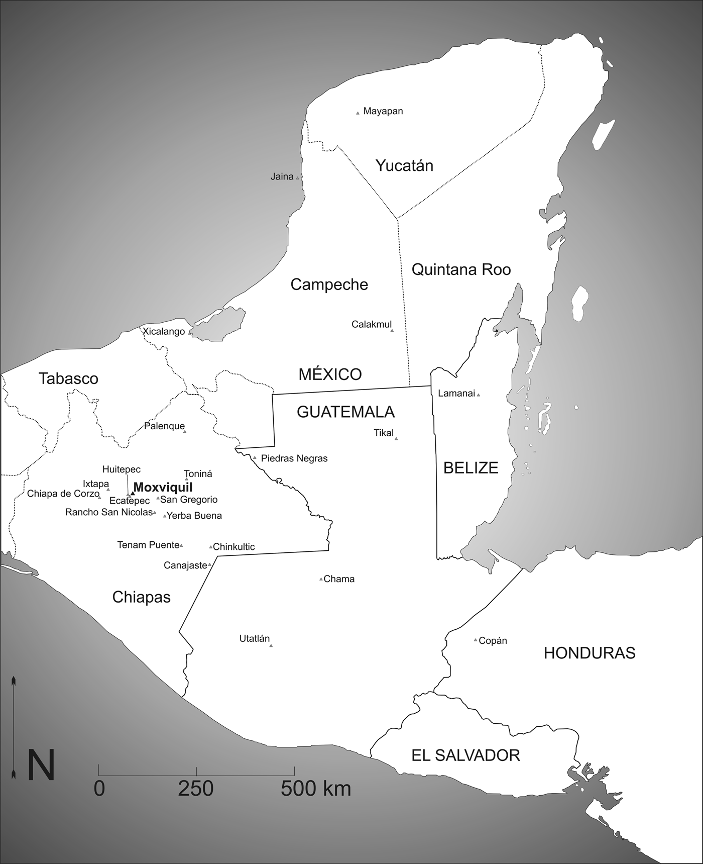
The small monumental center of Moxviquil is situated in a rugged and mountainous area in the Central Highlands zone of Chiapas, and sits atop a hill on the northern edge of the Jovel Valley, the location of the modern city of San Cristobal de las Casas (Figure 1). The Jovel Valley lies at one of the highest points in the Central Plateau at an altitude of 2,140 m asl near the city center, with limestone hills and escarpments surrounding the valley on all sides, while the Volcán de Huitepec dominates the southwestern skyline of the valley as an extinct volcanic cone created through the movement of a geological “hot spot” (Aubry Reference Aubry and de Lectura2008).
Map of the Maya region showing the location of Moxviquil and other sites mentioned in the text. Map by Elizabeth Paris.

The Jovel Valley lies on the western frontier of the Maya cultural region, in close proximity to several different climatic, geographic, and cultural zones. Running parallel to the Central Highlands (Los Altos), immediately to the south and west of the highlands, the Ixtapa Valley lies at 900 m asl, resulting in a milder, more tropical climate. The Ixtapa Valley was likely Mayan-speaking, but indicates strong ties to the Zoque-speaking areas to the west prior to the end of the Late Classic period (a.d. 700–1000) (McVicker Reference McVicker1969). Further still to the south and west lies the Central Depression of Chiapas, created by the Grijalva River Valley, which runs through its center (Bryant Reference Bryant, Bryant, Calnek, Lee and Hayden.1988:1), and was likely occupied by Zoque-speaking populations prior to the arrival of the Chiapanecs around a.d. 900 (McVicker Reference McVicker1969). Further south still lies the predominantly Mixe-Zoque speaking Sierra Madre de Chiapas and the Pacific (Soconusco) Coast. In contrast, the areas to the north and east were inhabited by Mayan-speaking populations. To the east, numerous Tzotzil and Tzeltal Mayan-speaking populations inhabited the neighboring areas of highland Chiapas, the Comitan Plateau, the Upper Grijalva River Valley, the Cuchumatan Mountains, and highland Guatemala (Bryant Reference Bryant, Bryant, Calnek, Lee and Hayden.1988:1; West Reference West, West and Wauchope1964:65). Further still to the north and northeast, the highlands gradually give way to hot, swampy lowlands of the Gulf Coast of Tabasco and the tropical lowlands of the Usumacinta River Valley (Bryant Reference Bryant, Bryant, Calnek, Lee and Hayden.1988:1; Piña Chan and Navarrete Reference Piña Chan and Navarrete1967).
Archaeological and ethnohistorical data suggest that highland Chiapas never sustained the larger, denser settlements of neighboring lowland areas, due in part to its high altitude, cold temperatures, and seasonal rainfall, resulting in relatively short agricultural growing seasons compared to the Central Depression and other lowland environments (Calnek Reference Calnek, Bryant, Calnek, Lee and Hayden1988). Instead, the highlands sustained a patchwork of small polities during the Late Classic (a.d. 600–1000) and Postclassic (a.d. 1000–1524) periods, which appear to have been politically autonomous (Adams Reference Adams and McQuown1959, Reference Adams1961; Culbert Reference Culbert1965; McVicker Reference McVicker1969, Reference McVicker1974; Paris Reference Paris2012). Several other sites in highland Chiapas date to the Late Classic-Early Postclassic transition and represent small hilltop cities of similar size as Moxviquil, including Ecatepec on the southwest edge of the Jovel Valley (Adams Reference Adams1961; Culbert Reference Culbert1965), Yerba Buena and Rancho San Nicolas near the Amatenango Valley to the southeast (Adams Reference Adams1961; Bryant Reference Bryant, Bryant, Calnek, Lee and Hayden.1988; Culbert Reference Culbert1965), San Gregorio in the Tzaconeja Valley to the northeast (Culbert Reference Culbert1965), and La Tortuga, Campo de Aviación, and V.S.2 in the Ixtapa Valley (McVicker Reference McVicker1969). Geographically, the nearest large Late Classic or Early Postclassic period cities to the Jovel Valley include Tonina to the east and Tenam Puente to the southeast; however, there is currently no evidence to suggest that highland sites were politically subordinate to either center.
Data on the Moxviquil monumental center comes from excavations of Frans Blom and Clarence Weiant, undertaken over two seasons from 1952 to 1953 (Blom Reference Blom1893–Reference Blanton1963, Reference Blom1952a, Reference Blom1952b, Reference Blom1953a, Reference Blom1953b, Reference Blom1953c, Reference Blom1954a, Reference Blom1954b, Reference Blom1958, Reference Blom1959; Blom and Weiant Reference Blom and Weiant1953, Reference Blom and Weiant1954; Blom et al. Reference Blom, Weiant and Lee Whiting1995; Evening Star 1954; Notes and News 1954; Weiant Reference Weiant1952, Reference Weiant1953a, Reference Weiant1953b, Reference Weiant1954a, Reference Weiant1954b). Their approach to the excavations reflected the explorer/adventurer perspective that pervaded in that era: the research lacked a problem-oriented design, excavations were placed for the maximum likelihood of finding tombs, structures were trenched and not consolidated or restored, drawings and photographs were made and taken only of the tombs and the largest and most elaborate structures, artifacts were incompletely analyzed, and the results were never fully published. Yet, as the archaeological remains at Moxviquil have suffered from extensive looting, logging activities, and erosion over the years, the results of Blom and Weiant's excavations become still more significant as potentially our best, or even last, source of knowledge about this monumental center.
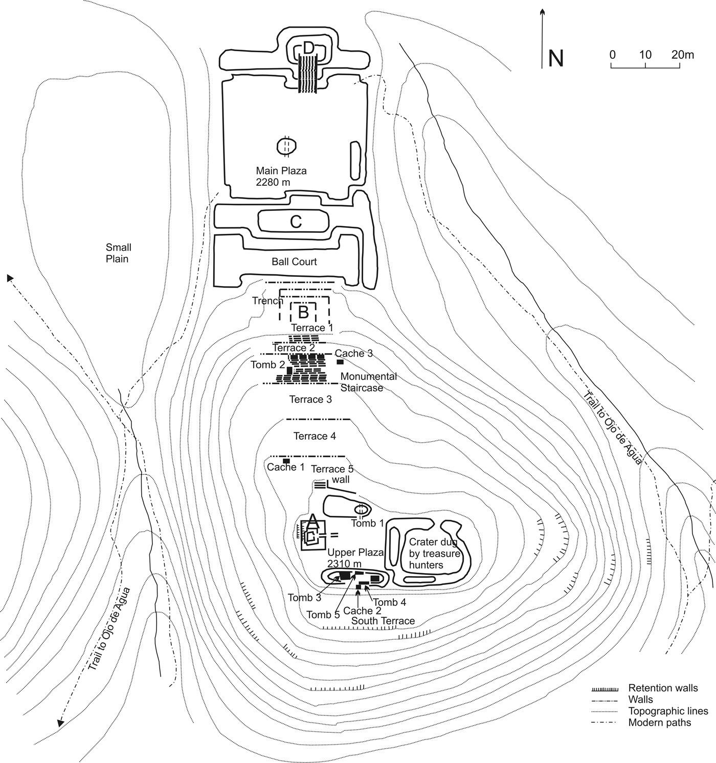
Blom was a Danish archaeologist and explorer, who moved to San Cristóbal de las Casas in 1950 with his wife, Swiss journalist and cultural anthropologist Gertrude Duby. His attention was first drawn to the site of Moxviquil by Licenciado Herminio Santiago Vital, a local teacher, who showed him a sherd incised with glyphs taken from the site. A visit to the site convinced him of its archaeological potential. He recruited Weiant, a chiropractor and amateur archaeologist, who had previously excavated with Matthew Stirling at Tres Zapotes, and then with Alfonso Caso at Monte Albán (Brunhouse Reference Brunhouse1976). In 1952, Blom and Weiant were able to obtain funding and excavation permits to begin their project. They began by clearing a wide swath of forest along the north-south access of the monumental center of the site, traversing the northern hillslope to the apex of the hill and the Upper Plaza (Figure 2). Next, Blom recruited school children from San Cristóbal and the adjacent village of Ojo de Agua, to hike up the mountain on Saturdays and scour the woods, collecting artifacts from the surface. Excavations in the 1952 season focused on the “Western Pyramid,” a small stone temple on the western edge of the Upper Plaza. A second and more extensive season during 1953 focused on the northern and southern temples of the Upper Plaza, the monumental staircase, the residential terraces, and the temples surrounding the Main Plaza. At the conclusion of the 1953 season, the artifacts, maps, photographs, and documents from the excavations were stored or displayed in the Museo Na Bolom, former residence of Blom and Duby in San Cristóbal de las Casas, now a museum, hotel, and nonprofit organization. At later dates, George Brainerd (ceramics), Thomas Lee Whiting (lithics), and Sean Brady and his colleagues, Ignacio J. March and Sven M. Aden (fauna), made inventories of select artifact types. In 2006 and 2008, Elizabeth Paris spent several months cataloguing, organizing, and re-analyzing the Moxviquil artifacts, and we believe that the results of these efforts will finally disseminate the work done by Blom and Weiant to a broader audience and refocus the results to address new theoretical questions in Mesoamerican archaeology.
Map of the monumental center of Moxviquil (digitally redrafted by Elizabeth Paris from the unpublished original by Frans Blom). Updated altitude data, recorded by Paris in 2009 with a Garmin Vista HCx GPS unit, suggest an altitude of 2,328 m asl for the Upper Plaza, and 2,300 m asl for the Main Plaza (from Paris Reference Paris2012).

Recent excavations by Paris and López Bravo (Paris Reference Paris2012) have documented that settlement at Moxviquil also included both elite and commoner residential settlement on four additional hilltops and ridgetops to the north and west of the monumental center, extending the area of known settlement for Moxviquil to approximately 5 km2. Survey and excavation suggests that as at the monumental center, residential zones were concentrated on hilltop areas and broad intermountain terraces, and were located on areas that contained artificial earthen or limestone rubble terraces. Because of seasonal flooding in intermountain saddle areas, residences were not located in lowlying saddle areas between hilltops, but were concentrated on higher hillslopes and ridgetops. In contrast to the monumental center, these hilltops lacked public architecture and appear to have been exclusively residential areas.
FRAMING THE LANDSCAPE: THE ARCHITECTURE OF THE MOXVIQUIL MONUMENTAL CENTER
The monumental center of Moxviquil was constructed along a north-south axis along the apex, northern slope, and base of a large hill on the northern edge of the Jovel Valley (Figure 2). The Upper Plaza of Moxviquil sits at the apex of the hill, at 2,328 m asl, while its Main Plaza, located in the saddle at the northern base of the hill, sits at an altitude of 2,300 m asl (Paris Reference Paris2012). While the northern slope of the hill is relatively gradual, the other three sides are steep and could have provided natural defenses in times of conflict. On the western slope, a small arroyo called Ojo de Agua flows in a deep ravine, while the eastern slope is slightly more gentle, and paths accessing the main plaza (modern, and likely ancient as well) provide access from the valley floor from this direction. To the north of the mountain lie two natural streams on either side of the Main Plaza, one called “la cordillera de Chupactic,” named after the Ejido Chupactic, the indigenous community that collectively owns the land (Blom Reference Blom1952b).
The form and organization of architecture found at the monumental center of Moxviquil suggest that they likely served a variety of functions for its own residents and for the surrounding residential areas of the site. The monumental center can be conceptually divided into three zones: an Upper Plaza at the apex of the hill, which likely fulfilled administrative and elite residential functions; a residential zone located on artificial terraces traversing the hillslope connected by a large monumental staircase; and a public monumental zone in the saddle at the base of the northern hillslope. These three zones are described in detail below.
The Upper Plaza
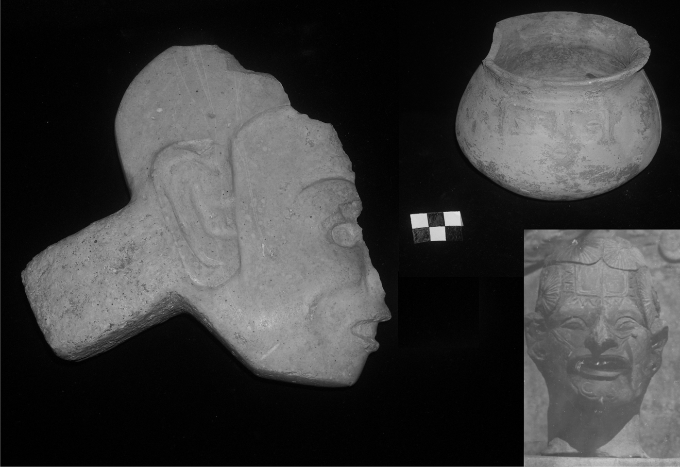
The administrative-elite residential zone at the apex of the hill consisted of the Upper Plaza (Blom Reference Blom1952b), a group of four structures around a small and square (20 × 20 m) courtyard. The hilltop was artificially flattened to create a broad terrace (Terrace 5). The Upper Plaza was dominated by the Western Pyramid (also referred to as “Structure A” and “The Sanctuary” in Blom and Weiant's records), a small rectangular shrine with an 8 × 9 m base located on the western size of the plaza (Blom Reference Blom1953b). An axial trench excavated by Blom and Weiant through the center of the Western Pyramid mound revealed a small, three-level pyramid topped by a rectangular structure with low, thick masonry walls (Weiant Reference Weiant1952, Reference Weiant1954a:31), suggesting that upper portions of the structure's walls may have been of wattle-and-daub construction, with a thatched roof (Weiant Reference Weiant1954a). The stepped platforms supported a rectangular masonry structure, with a masonry staircase leading to a single room (2 × 1.25 m) that contained a large bench that filled the rear half of the structure (Weiant Reference Weiant1954a). At Maya lowland sites such as Tikal, benches are often considered to have functioned as thrones in administrative structures (Harrison and Andrews Reference Harrison, Andrews, Evans and Pillsbury2004:141). The structure was associated with a number of artifacts (Figure 3), including a ceremonial Totonac-style hacha in the shape of a human head, made of fine-grained limestone, and deposited in the fill under the steps of the structure (Evening Star 1954). The bench/throne of the interior room was associated with small stone sculptures (Weiant Reference Weiant1952, Reference Weiant1954a:31), an elaborately modeled clay figurine depicting an elderly man with facial tattooing and filed front teeth (Blom Reference Blom1954b), and a small decorated jar. The opposing structure on the eastern side of the plaza (the “Eastern Pyramid”) may have once resembled the Western Pyramid. This structure has been completely looted and destroyed, an event that Blom's workmen claimed to have occurred sometime in the early 1900s (Weiant Reference Weiant1954a).
Artifacts from the “Western Pyramid” including a Totonac hacha carved in the shape of a human head in profile, a small Chax Modeled: Chax Variety jar, and a figurine with facial tattooing. Photos by Elizabeth Paris and Frans Blom. Reproduced with permission from the Asociación Cultural de Na Bolom.

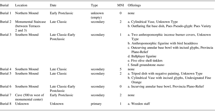
Structures on the northern and southern edges of the Upper Plaza suggest that they may have served as residential areas for high-ranking individuals, possibly the site's ruler and family. On the northern side of the plaza, the “Northern Pyramid” (also referred to as Mound 1) was a long, low mound measuring 12 × 4 m in plan view (Blom Reference Blom1953b). The excavation of a large axial trench revealed a rectangular tomb with masonry walls, named Tomb 1 (Table 1). Tomb 1 contained neither artifacts nor human remains, and was located directly beneath an Early Postclassic period floor at the southern edge of the mound, inside the plaza. Excavations at the “Southern Pyramid” (also referred to as the “South Mound”) suggested a structure nearly identical to the Northern Pyramid, which was associated with the highest proportion of tombs and caches found at the site. Weiant and his workers excavated an axial trench through the center of the 12 m-long mound, beginning approximately 3 m east of the center, and encountered a wall running the same direction as the trench (Evening Star 1954; Weiant Reference Weiant1954a); a similar, parallel wall was excavated on the west side (Weiant Reference Weiant1954a). These parallel walls delimited two stratified stucco floors (Weiant Reference Weiant1954a); the burials and caches were located between or beneath these floors.
Burials excavated at the monumental center of Moxviquil by Blom and Weiant (Reference Weiant1952–Reference Weiant1953)

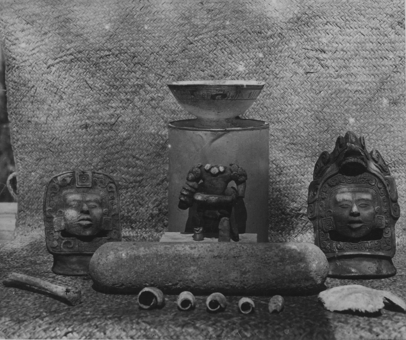
The tombs and caches recovered under the floors of the “Southern Pyramid” included some of the richest offerings found at the site, and included Tombs 3, 4, 5, and 6, and Cache 2 (Table 1). The masonry slabs composing Tomb 3 were observed by Weiant to be protruding from the highest stucco floor (Evening Star 1954) of the Southern Pyramid. Tomb 3 contained two incomplete human skeletal elements: a fragment of an unfused juvenile occipital cranium fragment, and the shaft of a juvenile human tibia with unfused epiphyses (mistakenly interpreted by Weiant as an animal bone) (Evening Star 1954). This suggests that these elements may represent the secondary interment of at least one juvenile elite individual (probably age 10 or younger). The tomb also contained a number of offerings, including two elaborately modeled incense burner covers depicting deities or elite individuals with facial tattoos, elaborate headdresses and earspools (Evening Star 1954) (Figure 4). Between them lay a white ceramic bowl with an incised design around the rim containing hieroglyphic elements and an annular rattle base belonging to the ceramic type Provincia Plano-Relief: Unspecified Variety. This type is an incised variant of Balancan Fine Orange Ware, which was produced in the Gulf Coast region and exchanged with surrounding regions during the transitional period from the Late Classic to the Early Postclassic (formerly known as Fine Orange Z) (Smith Reference Smith1958). Lying in the bowl was a headless figurine of a ballplayer in full regalia. The funerary offerings also included a small mano, and five olive shell tinklers with small perforations.
Contents of Tomb 3 from the Southern Pyramid, including two anthropomorphic effigy burner lids, a ballplayer figurine, a Provincia Plano-Relief: Variety Unspecified outcurving bowl with rattle base and hieroglyphic incised design, five olive shell tinklers, and two juvenile bone fragments including an unfused cranial fragment and a tibia with unfused epiphyses. Photo by Frans Blom. Reproduced with permission from the Asociación Cultural de Na Bolom.

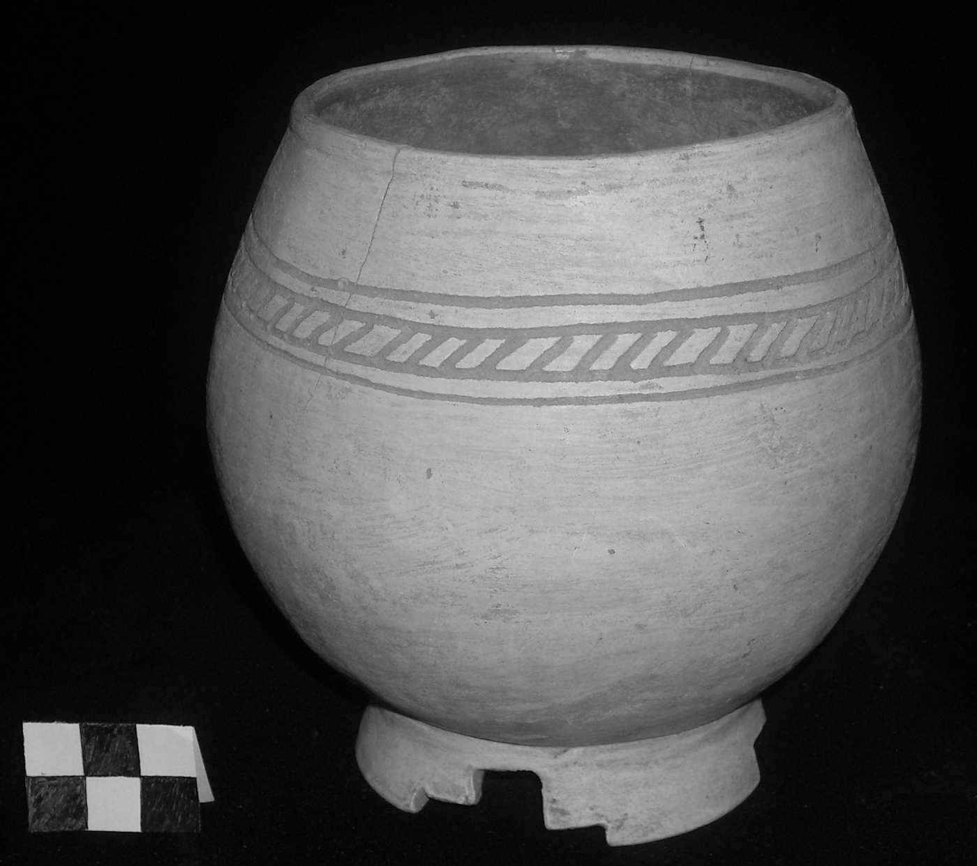
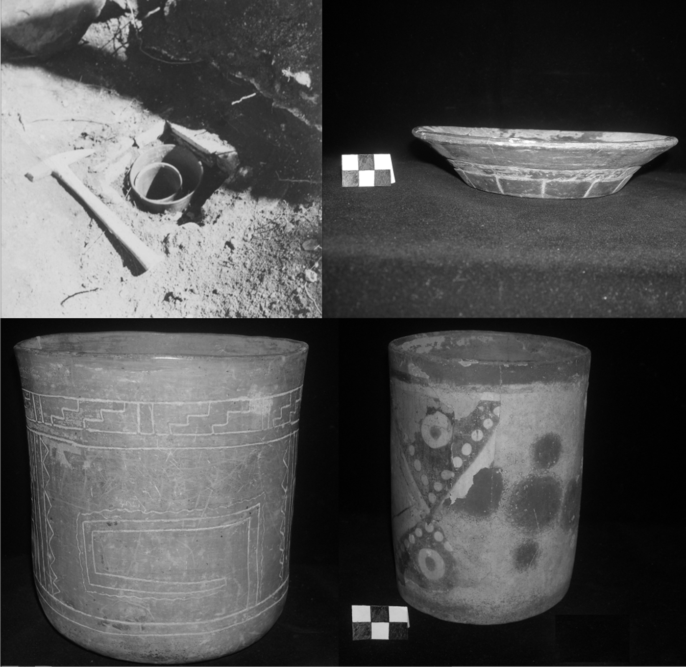
In the stratum below Tomb 3, Weiant and his workers encountered a second masonry tomb, named Tomb 6. This tomb contained a small white-slipped bowl with geometric design and an annular base (also Provincia Plano-Relief: Unspecified Variety) (Figure 5); excavation records suggest that no human remains were present in the tomb. The location of Tomb 6 was slightly offset from Tomb 3 by 25 cm to the south and 25 cm to the east. The tomb was superimposed over a stucco floor, which covered the entire platform. Below this stucco floor, immediately north of these two tombs was Cache 2 (Figure 6), a hollow cubic cavity constructed of uncut limestone masonry blocks in a style identical to the tombs (Weiant Reference Weiant1954a). Cache 2 contained two cylindrical vessels, one inside the other, of unidentified ceramic types. The larger vessel was a Fine Orange vase with geometric incised decoration; the smaller vessel was decorated through two techniques: a bright red slip on the rim with a white and black geometric design on the body achieved through the “lost-color” process (negative painting), and covered with a layer of stucco painted pale green with dark red circular blotches. Standing upright beside these vessels was a shallow grayware dish with a stamped pseudo-glyph design, a type that has recently been designated as Pues Pseudo-glyph, and is a Late Classic type associated with sites in the Upper Grijalva River Valley (Bryant et al. Reference Bryant, Clark and Cheetham2005).
Provincia Plano-Relief incurving bowl with incised geometric design, with an annular base with a step-fret motif. Recovered from Tomb 6 in the Southern Pyramid. Photo by Elizabeth Paris.

Cache 2 and artifacts from the Southern Pyramid including a Pues Pseudo-glyph: Pues Variety plate and two cylindrical vases, one Undesignated Fine Orange vase and one Undesignated black-on-white negative painted cylindrical vase with a thin layer of dark red and green painted stucco. Photos by Elizabeth Paris and Frans Blom. Reproduced with permission from the Asociación Cultural de Na Bolom.

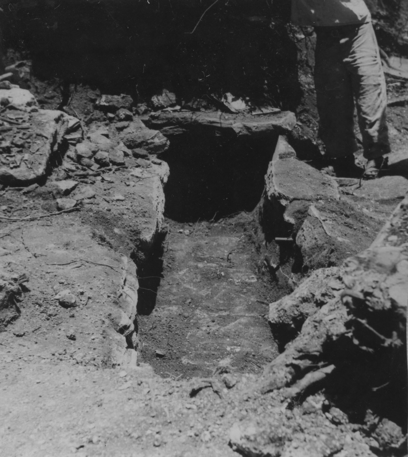
A third masonry tomb, designated Tomb 4, was encountered during excavations by Weiant and his workers along the edge of, and under, the stuccoed floor connecting the two walls of the Southern Pyramid (Evening Star 1954). Tomb 4 was 5.15 × .52 m in size, and was located just over 1 m to the north of Tomb 3, and 90 cm north of Cache 2, below the stucco floor (Figure 7). The tomb contained the secondary interments of at least five individuals of various ages; skulls and mandibles were piled at each end, while the other bones were piled together in the center (Weiant Reference Weiant1954a:34). According to Weiant (Reference Weiant1954a:34), the skulls exhibited “cranial deformation characteristic of many Maya individuals, in which boards were strapped to the forehead and under the base of the cranium.” Unfortunately, Weiant does not name the particular type of deformation exhibited. His description, however, is most consistent with parallo-fronto-occipital modification (Neumann Reference Neumann1942:Figure 37).
Tomb 4, from the Southern Pyramid, a rectangular masonry tomb with limestone brick walls and thin limestone lintels covering the tomb (removed). Photo by Frans Blom. Reproduced with permission from the Asociación Cultural de Na Bolom.

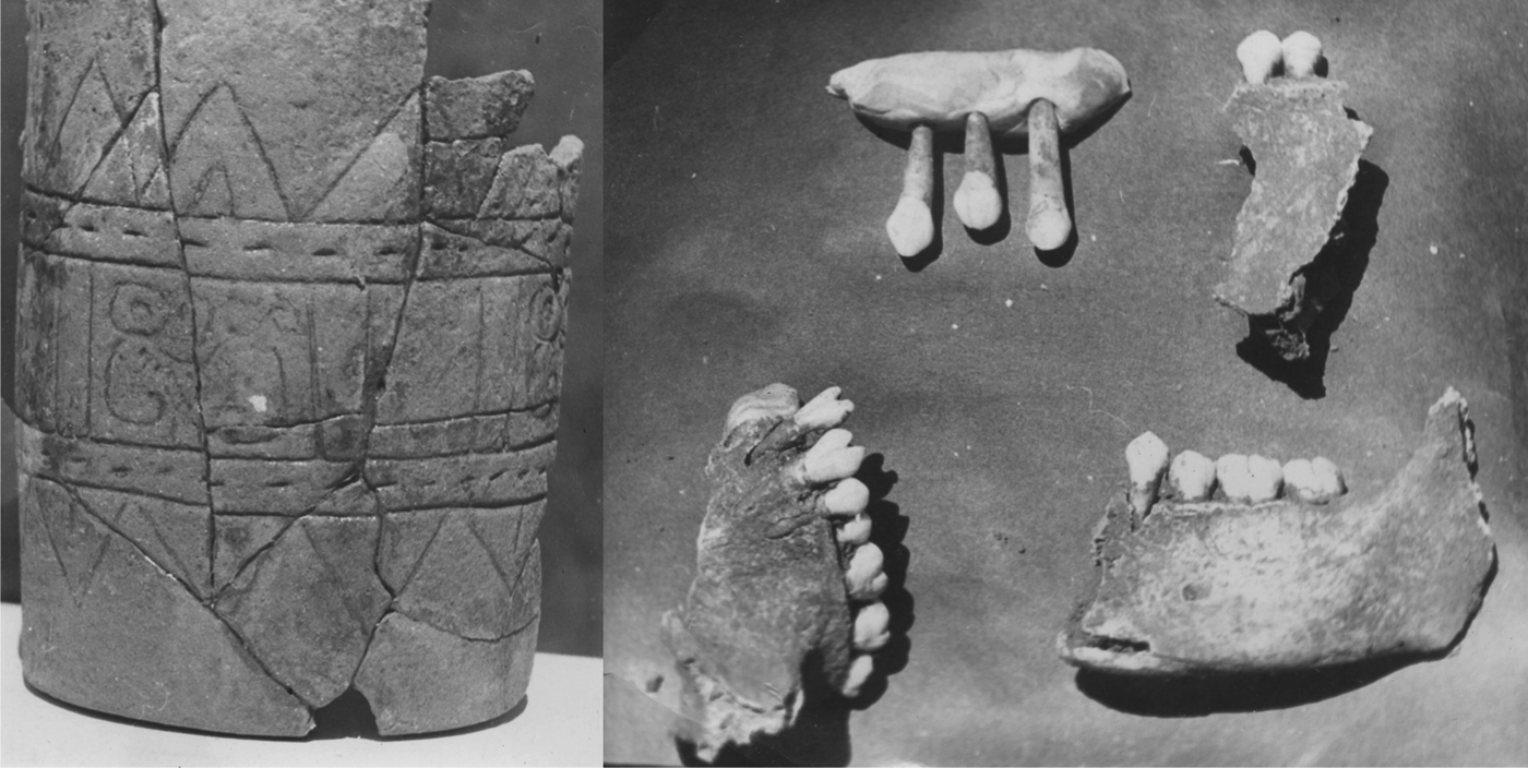
Weiant recovered a fourth masonry tomb, designated Tomb 5, further north of the other tombs. This tomb contained an exteriorly projecting masonry niche in the wall that held a tripod plate with three solid nubbin supports and negative painting (Blom Reference Blom1953b). It also contained a cylindrical vessel with an incised band of glyphs around the exterior (Figure 8). Human remains in Tomb 5 included a large (unspecified) number of femurs and tibias, piled in the center of the tomb, with the cranial fragments of at least eight people piled on top (Weiant Reference Weiant1954a:34). Two of the cranial fragments from this tomb are on exhibit at the Museo Na Bolom and were available for study. One fragment (Figure 8) likely represents the upper right maxilla of a young male with a newly erupted third molar and bifurcated dental modification of the incisors (Type I.1) (Buikstra and Ubelaker Reference Buikstra and Ubelaker1994:59; Rosario Acosta, personal communication 2009). The other fragment is a lower left mandible fragment, in which both premolars and LM1 are preserved, while LM2 and LM3 have fallen out, and the bone has been reabsorbed, suggesting that the individual was slightly older and/or had poor dental health.
Artifacts from Tomb 5, from the Southern Pyramid, including an Undesignated Fine Orange cylindrical vase with hieroglyphic incised design and human maxilla and mandible fragments, some displaying bifurcated dental modification of the incisors. Photos by Frans Blom. Reproduced with permission from the Asociación Cultural de Na Bolom.

The Residential Terrace Zone
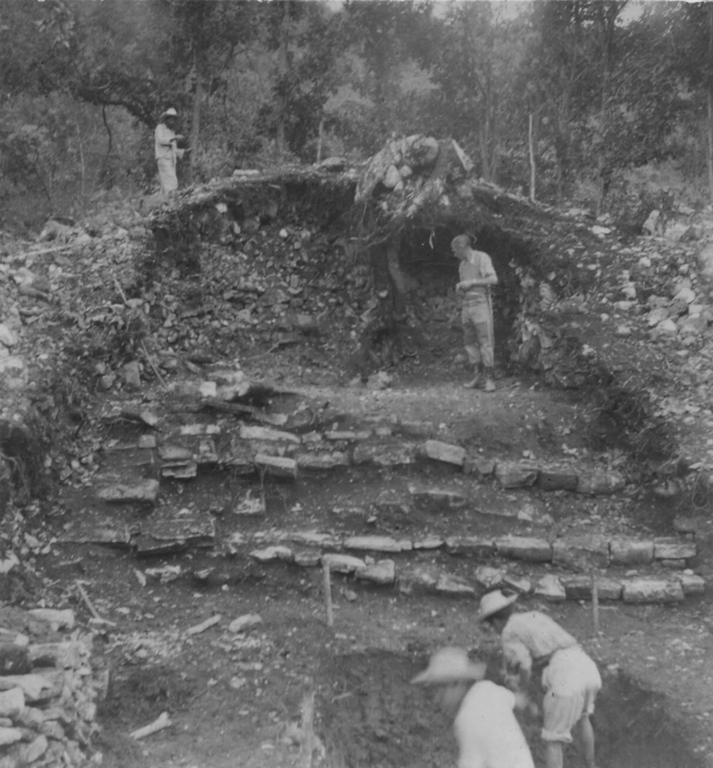
Below the Upper Plaza, the slopes of the mountains were steeply terraced on all sides, simultaneously creating a series of defined architectural spaces, combating erosion, and reinforcing defenses. As discussed below in detail, Blom and Weiant's excavations suggest that the terraces on the northern slope served as residential areas. The terraces on the southern slope were considerably steeper than those on the northern slope, and were not excavated by Blom and Weiant, so it remains uncertain whether they were also inhabited. Each of the five terraces on the northern slope of the hill was girded by a massive retention wall made from unworked limestone blocks, with a large monumental staircase (Figure 9) approximately 15 m wide running from Structure B to the Upper Plaza, connecting each terrace with the next (Weiant Reference Weiant1954a). The monumental staircase provided a highly centralized and formal mechanism for travel and communication between the terraces of the monumental zone. There was some discrepancy between Blom's map and Weiant's description of the terraces in his articles and notes. Thus, Terrace 5, as labeled on the map, is Terrace 4 in Weiant's notes, while Terrace 5 contains the Upper Plaza. The following description uses Weiant's notes, descriptions, and labeling system.
The monumental staircase connecting the terraces, with Weiant posing at the top. Photo by Frans Blom. Reproduced with permission from the Asociación Cultural de Na Bolom.

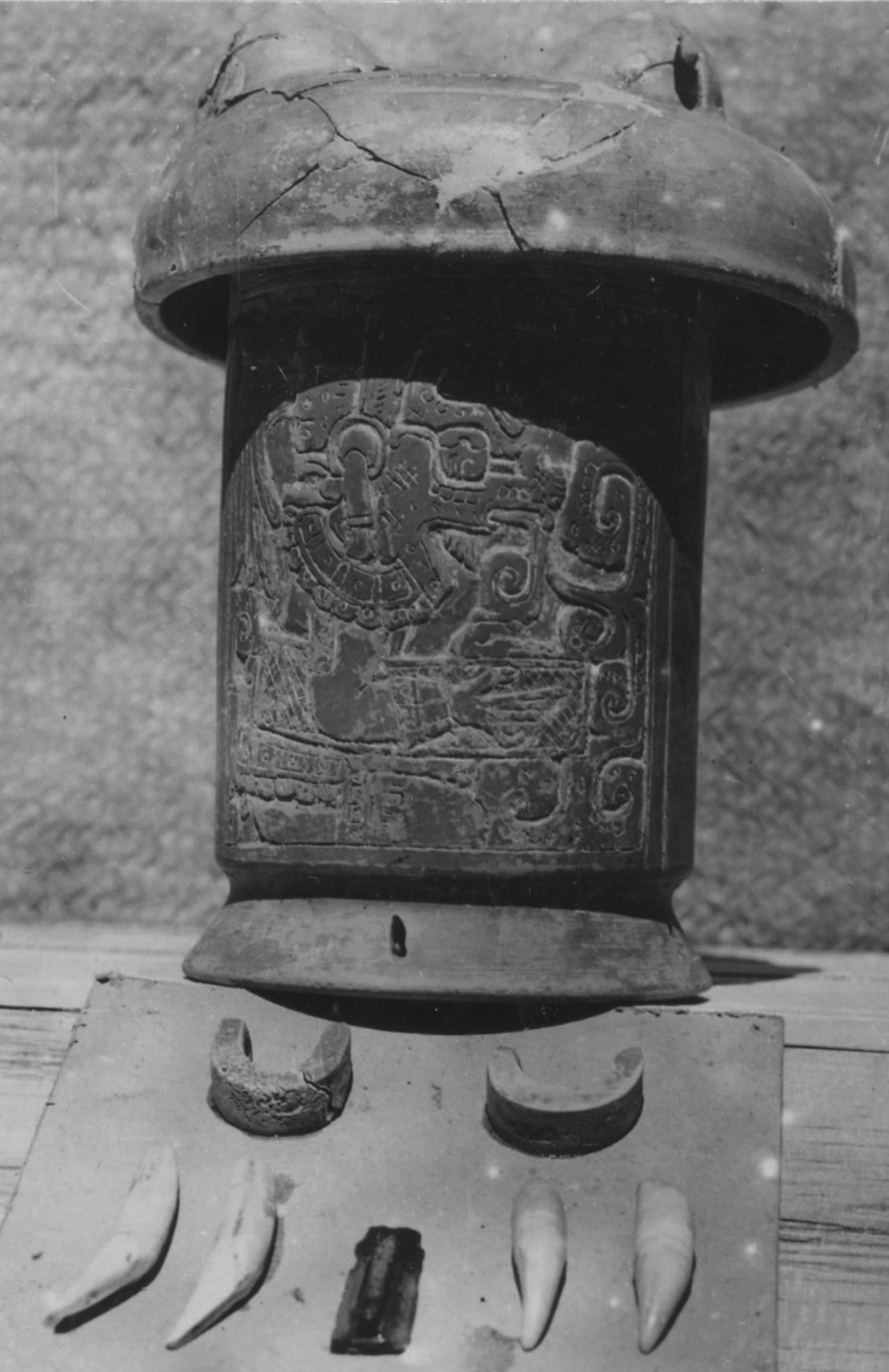
Consistent with its close proximity to the Upper Plaza, excavations on Terrace 4 revealed dwellings with rich offerings. Excavations in the northwest corner of the terrace revealed architectural remains suggesting an elite residence, consisting of a stone wall and a stucco floor that had been painted red (Blom Reference Blom1958). In the corner of the structure abutting the retaining wall of Terrace 5, Weiant and his workers discovered Cache 1 (Figure 10), which contained an elaborately incised cylindrical vessel depicting the Maya deity K'awiilFootnote 1 in profile wearing an elaborate feather headdress, necklace, earspools, and carrying a woven mat under its arm. Smith (Reference Smith1958) classified this vase as belonging to the ceramic group Silho Fine Orange from the Gulf Coast (also known as Fine Orange X). The mouth of the vase was covered with an inverted Fine Orange tripod bowl, and within the vase were two jaguar fangs, two peccary tusks, two bone atlatl [spear-thrower] finger loops, and an obsidian blade (Weiant Reference Weiant1954a:34).
Contents of Cache 1, including a Silho Fine Orange annular base cylindrical vase with an incised panel depicting the Maya god K'awiil, an Undesignated Fine Orange tripod bowl, two jaguar fangs, two peccary tusks, two bone atlatl fingerloops, and an obsidian blade. Photo by Frans Blom. Reproduced with permission from the Asociación Cultural de Na Bolom.

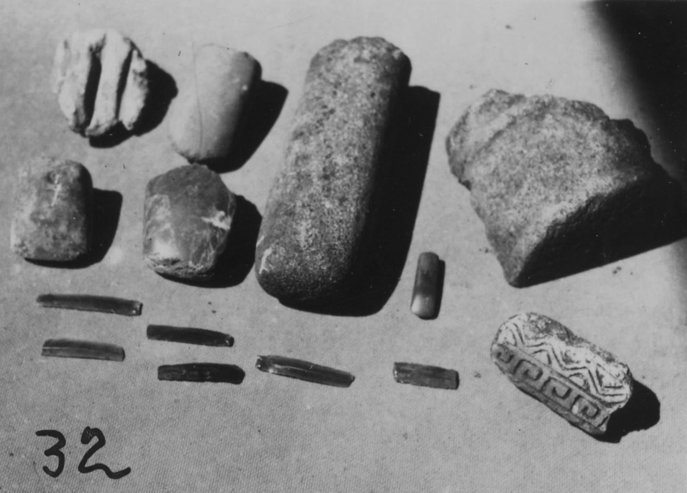
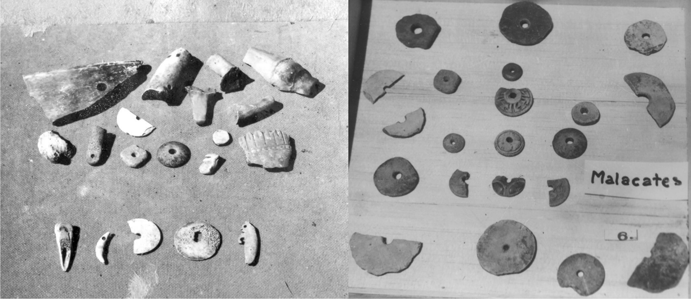
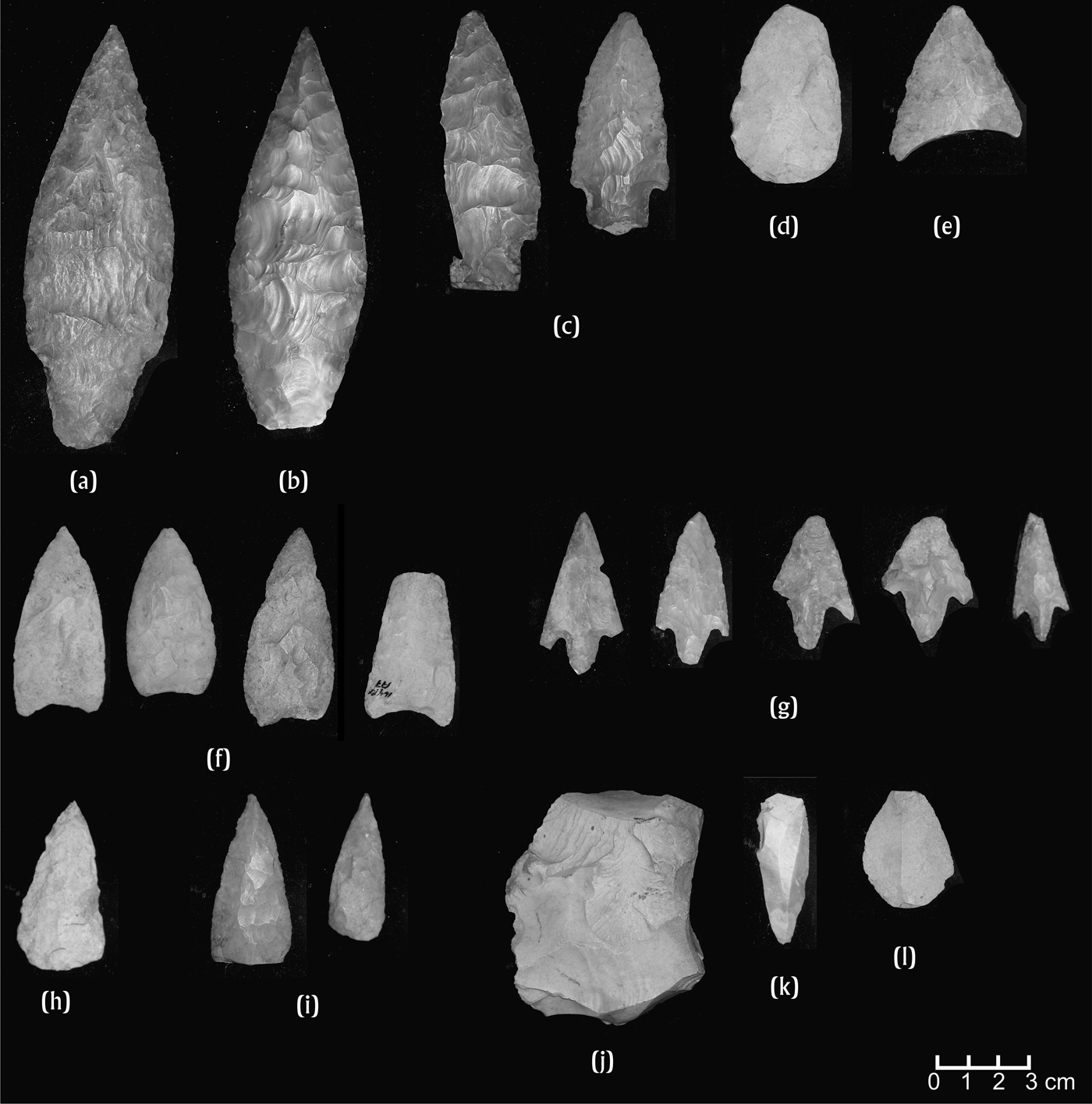
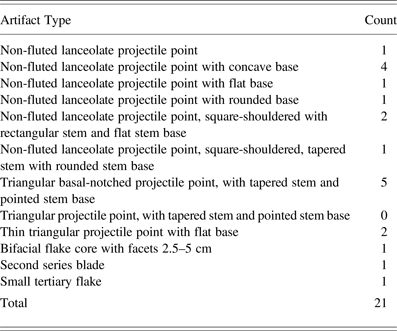
Further evidence of residential occupation was recovered on Terrace 3. Excavations recovered a broad terrace transected by the monumental staircase, containing a series of low masonry walls, which likely supported perishable wattle-and-daub superstructures with thatched roofs. Weiant (Reference Weiant1954a:32) recovered dense deposits of artifacts in association with these structures that reflected a wide range of production activities and consumer goods. These artifacts are discussed in detail below; they included dense deposits of lithic tools, production implements, and debitage, including large quantities of projectile points in an array of sizes and styles, numerous chert nodules, partially modified flakes, production rejects and debitage, and deer antler tines likely used in flintknapping. Other artifacts recovered from this terrace included ceramic sherds, figurine fragments, spindle whorls, groundstone implements, and obsidian blades and prismatic blade cores (Figure 11). Weiant (Reference Weiant1952:4) also notes the presence of similar types of domestic refuse on the surface of Terrace 2, such as “several beautiful incised sherds, obsidian flakes, an arrow point, several cabecitas (little [figurine] heads), and several mountains of culinary ware and plain sherds.”
Artifacts from Terrace 3, including groundstone axes, a groundstone mano, a cylindrical sculpture fragment, six obsidian blades, and a ceramic stamp. Photo by Frans Blom. Reproduced with permission from the Asociación Cultural de Na Bolom.

As on the upper terraces, the lower terraces were also the site of ritual deposits including both tombs and caches. A masonry tomb, Tomb 2, was located on western edge of the staircase, about half way between Terraces 2 and 3 (Table 1). The thin stone slabs covering the tomb had collapsed post-depositionally, crushing the skull and postcranial skeletal remains of an individual, and breaking a polychrome cylindrical ceramic vessel into hundreds of pieces (Blom Reference Blom1954b:Vessel 93). The mortuary remains were likely a secondary burial, as they consisted of long bones piled in the center of the tomb (Blom Reference Blom1953c). At the foot of the tomb, Weiant found a complete Pues Pseudo-glyph: Pues Variety dish, almost identical to the vessel found in Cache 2. Fragments of an adult cranium and three teeth from a juvenile mandible attributed to Tomb 2 are on display at the Museo Na Bolom. The adult cranium exhibits tabular erect cranial deformation, and may be the skull mentioned in publications by Romero Molina (Reference Romero Molina, Steward and Wauchope1970) and Comas (Reference Comas1960). The three juvenile lower incisors are complete and unmodified.
On the opposite (eastern) side of the monumental staircase, Weiant and his workers discovered another offering on Terrace 2, designated Cache 3. The description of its contents varies in the different notes and photos taken by Blom and Weiant, but based on labels on the artifacts themselves and original excavation photographs, the cache included numerous ceramic vessels, including three long-necked polychrome jars with opossum effigy necks (Yerba Buena Fine: Polychrome Variety), a direct rim bowl with gouged geometric decoration, an incurving annular base vase, an outleaning dish with incised geometric decoration, a Fine Orange annular base dish with a carved step-fret motif, and an outcurving Ixtapa Orange bowl (Figure 12).
Ceramics from Cache 3 including a Fine Orange annular base dish with a carved step-fret motif, an incurving bowl, an incurving annular base vase, an outcurving bowl with gouged geometric decoration an outleaning dish with incised geometric decoration, two long-necked polychrome jars with opossum effigy necks (Yerba Buena Fine: Polychrome Variety), and an outleaning Ixtapa Fine Orange bowl. Photos by Elizabeth Paris.

Terrace 1 contained post-conquest remains, including a Colonial period chapel and a corn silo possibly dating to the late nineteenth or early twentieth century. Blom and his workers recovered the foundations of a small adobe chapel, with ornamental stucco scrolls on the façade around the doorway stylistically consistent with the last quarter of the sixteenth century (Blom Reference Blom1958; Weiant Reference Weiant1954a). Blom (Reference Blom1958) proposed that the chapel was built on behalf of the Dominican friars led by Bishop Bartolomé de Las Casas who arrived in the Jovel Valley in 1545, as a temporary residence while they were awaiting completion of a more elaborate church in town. Furthermore, Blom (Reference Blom1958) suggested that the presence of the chapel in this location indicated that the monumental center of Moxviquil was still occupied during the early Colonial period. A second architectural feature on Terrace 1 was a post-conquest “Troje de Maíz” (corn silo) made with stones taken from the pre-Columbian ruins. Blom noted that the workers still remembered the existence of this troje (Blom Reference Blom1958).
The Public Monumental Zone
The saddle at the base of the northern hillslope of Moxviquil contained a small, concentrated, and diverse group of architecture that likely served a variety of functions for residents of the site located on the hillslope above, for other site residents occupying adjacent hilltops and ridgetops, and for the other small residential sites in the valley such as Huitepec (Paris Reference Paris2012) and La Hermita (Culbert Reference Culbert1965). These include three structures, labeled “Structure B,” “Structure C,” “Structure D,” an I-shaped ballcourt, and a large, square Main Plaza.
Structure B (also labeled “Pyramid B” by Blom and Weiant) was a large, truncated earthen mound located at the southern edge of the saddle, at the base of the monumental staircase and below Terrace 1. Blom had originally hypothesized that this structure was a masonry temple, and excavated a wide trench through the center of the mound down to several feet below the ground surface. No evidence of tombs or masonry structures was found; however, the workers removed several massive boulders. According to Weiant (Reference Weiant1954a), the only artifact recovered from the fill was a polished and perforated jadeite bead, which was recovered at the center of the base of the mound (Weiant Reference Weiant1954a).
To the north of Structure B, a series of platforms led from the base of the mound down to the ballcourt. Although not a true staircase, they were designated the “Northern staircase” by Blom and Weiant (Weiant Reference Weiant1954a). The ballcourt is “I” shaped, of a Type VII enclosed court (see Taladoire Reference Taladoire1981), with strong similarities to those of other Late Classic period sites in Chiapas such as Chinkultic, Tenam Puente, and Tonina. It is an enclosed ballcourt, with an east-west orientation, about 30 m long, with an alley about 8 m wide and a total width of 14.5 m (Blom Reference Blom1953b). The northern side of the ballcourt was bordered by Structure C, a long, low artificial truncated mound approximately 6 m high and 20 m long (Evening Star 1954; Weiant Reference Weiant1954a).
At the northern-most portion of the monumental center of Moxviquil was the Main Plaza and Structure D. The Main Plaza was likely the focal point of the monumental center (Weiant Reference Weiant1954a). The plaza was large and square, measuring approximately 45 × 45 m (Blom Reference Blom1958). The plaza was bordered on the southern edge by Structure C, on the northern edge by Structure D, and on the eastern and western edges by a series of low mounds (Blom Reference Blom1958). To the north of the Main Plaza, Structure D (also labeled by Blom as the Main Pyramid) was a three-level masonry pyramid approximately 40 m long. Blom excavated a wide trench across the center of the Main Plaza. Blom also excavated a large trench across Structure D, and uncovered a central staircase with four steps made of masonry blocks, but found few artifacts.
Other Mortuary Deposits
In addition to the mortuary deposits recovered from the Upper Plaza and the terraced residential zone, two additional burial deposits were recovered from the vicinity of the Moxviquil monumental center (Table 1). Following the excavation of the Moxviquil monumental center, Blom (Reference Blom1954a:131–134; later cited by Ruz Lhuillier Reference Ruz Lhuillier1968:105) recorded another burial in a cave located 500 m to the west. The deposit contained two fragmented skulls exhibiting cranial modification, along with a few dispersed bones. The dripping calcareous water had fossilized the whole deposit into a solid travertine block. Blom was still able to distinguish cranial deformation of the Antero-Posterior Type A among the skull fragments, and he states that it differs from the Tabular Deformation Type B registered on the Moxviquil burials. According to Blom, the cave was likely an ossuary with secondary burials as it contained a few “coarse” offerings in contrast to the rich offerings of the Moxviquil burials, and he suggested that the burials date to the Early Postclassic (Blom Reference Blom1954a:131–134).
According to Jovel Valley resident and author Herberto Morales, a seventh, unreported tomb may exist at the monumental center of Moxviquil. While researching a novel in 1990, Morales was shown a tomb by residents of Ojo de Agua, who claimed to have discovered the tomb while cutting wood on the hillside (Herberto Morales, personal communication 2010). Morales observed a masonry tomb covered with stone slabs. Unlike other tombs at the site, he observed that the walls were covered in white stucco, and that painted in the center of each wall was a red ochre design depicting a bird with large eyes, which he interpreted to be owls. The red paint sparkled in the light, an effect that was most likely due to the presence of specular hematite (specularite) crystals within an unhydrated (red) hematite-rich clay pigment. According to Morales, the tomb contained an adult primary burial, in which the body was in an extended supine position with its head to the north. The sole burial offering was a “xahuax te’” or wooden staff, resembling the type carried by religious officials in San Juan Chamula, located 9 km to the northwest of San Cristóbal de las Casas. While the recounted discovery is intriguing, it should be noted that archaeologists have not relocated the tomb, and the chronological provenience of both the tomb and its occupant remain uncertain.
The architecture of the Moxviquil monumental center reflects a diversified set of public and residential functions for both monumental center residents and the outlying residential populations. Evidence from Blom and Weiant's excavations suggests a spatial separation between residential settlement on the hillslope above, and public functions in the saddle below. The Upper Plaza may have served as both a local political administrative center and as the residences of the site rulers. Other residential areas were associated with the lower terraces on the hillslope; their lower position on the hillside is suggestive of lower status than their Upper Plaza counterparts. These structures likely represent the houses of extended members of the royal family, other high-status residents, and their retainers. Other residences likely filled the terraces to the east and west of the excavated areas. Both the Upper Plaza and the residential terraces below would have had restricted access to the public. The monumental staircase provides the only evidence of a nonperishable form of access between terraces, while the large retaining walls would have provided steep barriers to vertical movement up the hillside.
Burials and caches were concentrated in the residential hillslope areas, suggesting that the interments may be closely tied to the activities of individual households. All of the interments excavated by Blom and Weiant represent secondary interments, and often housed multiple individuals, suggesting that they were the loci of ongoing mortuary practice, possibly over multiple generations. As has been argued for other sites in the Maya cultural area, interments could have been used to evoke social memory of past action by reinforcing the claims of particular households to particular social and physical spaces (Chase and Chase Reference Chase, Chase and Houston1998; McAnany Reference McAnany1995). The tombs may represent the interments of revered family ancestors (McAnany Reference McAnany1995); however, it should be noted that the interred individuals include children, although the majority appear to have been adults. The tombs thus likely represent family mausoleums, in which individuals were interred and removed during multiple mortuary events. The formal, masonry caches interred within the residential spaces, often in close proximity to masonry tombs, represent a spatially segregated set of offerings from those interred within the tombs. This suggests that caches were also associated with highly formalized ritual within residential spaces, but may have served a separate function. For example, they could have been dedicated to deities rather than family ancestors.
In contrast, the saddle areas of Moxviquil likely served diverse public functions for a broad spectrum of valley residents. As noted above, these areas would have been more publically accessible to not only residents of the hillslope above, but also to residents inhabiting the other hilltops and ridgetops to the north and west (Paris Reference Paris2012), or to residents of other sites in the Jovel Valley who could have accessed the plaza through footpaths along the more gradual eastern slope ascending from the valley floor. Structure D could have served as a public temple or an administrative building connected to activities in the Main Plaza, while the large, truncated earth platforms (Structures B and C) likely served as spaces for important public rituals related to religious functions such as ceremonies and/or dances, or to administrative rituals for political leaders. Similarly, the Main Plaza could have served a wide variety of functions related to political events, rituals taking place at the temples on either side of the plaza, public gatherings, or economic functions such as a marketplace. The ballcourt would also have potentially accessible to the public during games, and would likely have played an important role in the forging of community identity (Hill and Clark Reference Hill and Clark2001:331).
Despite the importance of architectural inventories and urban planning in determining the degree to which activities were diversified or specialized within the monumental center of Moxviquil, the types and quantities of artifact assemblages in association with different architectural spaces provide equally important data on urban functions. The spatial distribution and densities of different types of production debris and finished commodities, as well their associations with particular architectural features, can link particular activities to particular households or social groups within the site (Ashmore Reference Ashmore2002; Folan et al. Reference Folan, Gunn, del Rosario Domínguez Carrasco, Inomata and Houston2001; Hendon Reference Hendon1996; Joyce Reference Joyce1993; Kent Reference Kent and Kent1990; Meskell Reference Meskell1999), or to the specialization of a community as a whole with regard to a particular activity such as agricultural production and storage, market activities, specialized craft production centers, or specialized religious rituals (Iannone and Connell Reference Iannone, Connell, Iannone and Connell2003:4).
THE CERAMICS OF MOXVIQUIL
The ceramics from the monumental center of Moxviquil highlight the diverse range of activities taking place in the Moxviquil monumental center. The assemblage reflects both private domestic consumer and storage activities, as well as more public events such as feasting and special-purpose ritual ceramics. The quantity and diversity of imported ceramics also lends support to the potential role of the Moxviquil monumental center as a market center, with its residents as consumers of interregional goods.
Information on the Moxviquil ceramics comes from three major sources: two notebooks filled with notes and sketches prepared in 1953 by WeiantFootnote 2 and in 1954 by Brainerd,Footnote 3 and a modal analysis by Paris of the complete ceramic collections preserved at the Museo Na Bolom, both the vessels on display at the museum (mostly whole vessels) and the collections in the bodega (mostly sherds and some whole vessels removed for restoration). Additionally, several researchers have included select whole vessels on display in the Museo Na Bolom in their comparative ceramic studies (Adams Reference Adams1961; Bryant Reference Bryant, Bryant, Calnek, Lee and Hayden.1988; Culbert Reference Culbert1965; Lee Reference Lee1985, Reference Lee1989; Lowe and Mason Reference Lowe, Mason, Willey and Wauchope1965; McVicker Reference McVicker1969, Reference McVicker1974, Reference McVicker, Lee and Navarrete1978; Piña Chan Reference Piña Chan1961, Reference Piña Chan1967; Smith Reference Smith1958; Taladoire Reference Taladoire2011). It should be noted, however, that the ceramic sample preserved in the Museo Na Bolom does not represent the entire excavated sample from the Moxviquil excavations. Blom and Weiant's writings indicate that an unspecified number of sherds were sent to Alfonso Caso in Mexico City, and many of the sherds that appear in the excavation photos are no longer present in the collection. It appears likely that only a selection of the originally excavated sample remains. Despite these concerns, it is still possible to associate different spaces with different activities, while acknowledging that not all activities may be represented in the remaining artifact sample.
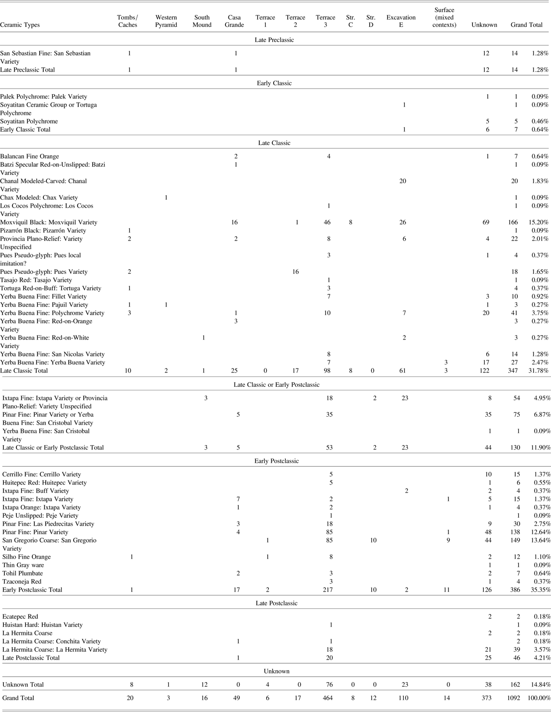
The three studies described above document 1,092 sherds and whole vessels from the monumental center of Moxviquil (Table 2). A total of 930 sherds and whole vessels were matched to 43 previously established Type-Variety categories (see also Paris Reference Paris2012), while the remaining 162 ceramics belong to undesignated or unknown types. Established types in the sample derive chronologically from the Late Preclassic period (1.28%), the Early Classic period (.64%), the Late Classic period (31.78%), the Early Postclassic period (35.35%), and the Late Postclassic period (4.21%), while 11.9% may have belonged to either the Late Classic or Early Postclassic periods. An additional 14.84% of vessels are of undesignated or unknown type, although many are bichromes or trichromes illustrated by Weiant that likely date to the Late Classic period. This suggests that the monumental center was first constructed during the Late Classic period, and that settlement continued through the Early Postclassic period. The small proportion of ceramics dating to the Late Postclassic period suggests that the population may have declined during this period. Ceramics from the outlying residential areas of Moxviquil date almost entirely to the Early Postclassic period, suggesting that the population of the site expanded into previously uninhabited areas on the surrounding hilltops at that time (Paris Reference Paris2012).
Type-Variety designations of ceramics from the Moxviquil monumental center by excavated context and time period
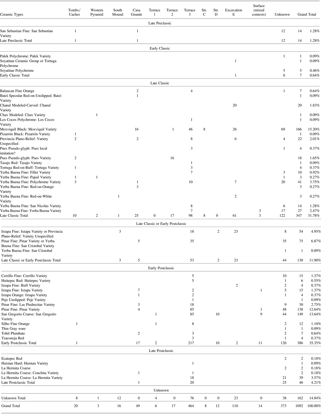
The sample of ceramics from the Moxviquil monumental center comes from a variety of excavated contexts ranging from residential terraces to burials and caches. The largest sample of ceramics derives from Terrace 3 (n = 464). The next largest samples of sherds are from two unknown excavated locations: the “Casa Grande” (which likely refers to either the North Mound or the South Mound in the Upper Plaza) and “Excavation E.” Small samples of sherds remain from excavation on Terraces 1 and 2; from the Western Pyramid and the South Mound in the Upper Plaza; from Structures C and D in the Public Monumental Zone; from Tombs 2, 3, 5 and 6; and from all three caches (n = < 20). For a large number of the sherds (n = 373), specific provenience information has been lost in the years since the excavations, and thus they shed light on monumental center activities only at the broadest level.
Storing, Serving and Sanctifying: Ceramic Vessels and Monumental Center Activities
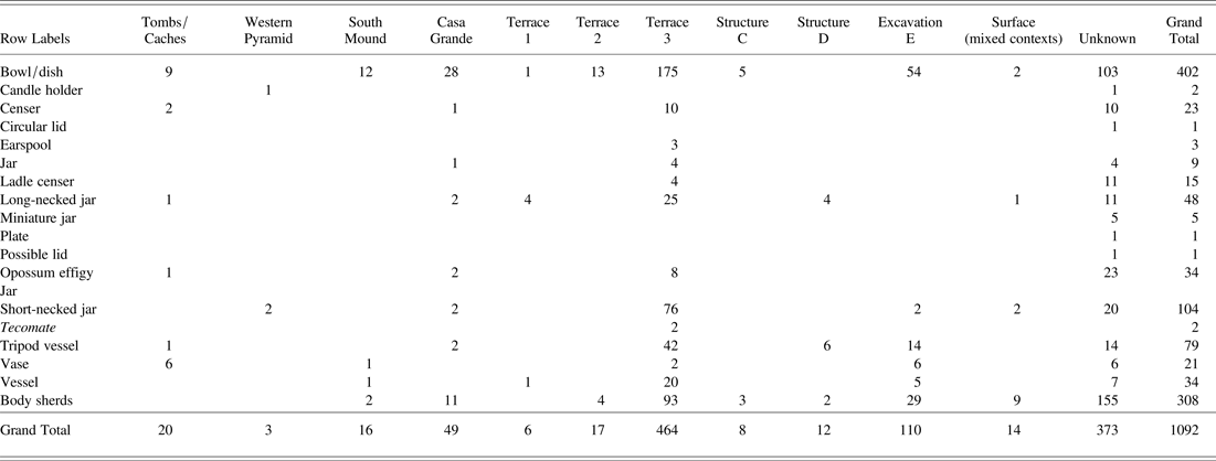
The ceramic assemblages at Moxviquil included a wide variety of ceramic forms ranging from utilitarian storage vessels, to serving and feasting wares, to special-purpose ritual vessels (Table 3). Bowls and dishes formed the largest proportion of the total assemblage in most contexts, while the second and third most common vessels were short-necked jars and tripod vessels. This pattern was strongly reflected on Terrace 3, which also had the largest sample of ceramics; however, bowls, dishes, and short-necked jars were also the dominant forms on Terraces 1 and 2, despite the small sample sizes. These activities reflect the importance of daily household activities such as food storage and consumption in association with the residences on this terrace. Terrace 3 was also the only location within the monumental center where tecomates (neckless incurving jars) were found, although these vessels were also likely related to food storage. This terrace also had a diverse range of special-purpose ceramics, including cylindrical vases, incense burners, and ceramic earspools, suggesting that residents also engaged in ritual activities within or beyond these residential spaces.
Vessel forms of ceramics from the Moxviquil monumental center by excavated context

The vessels from tombs and caches reflect the specialized nature of these ritual deposits. Both tombs and caches contained high proportions of cylindrical vases, which may have been used as ceremonial drinking vessels at feasting events. These deposits also contained high proportions of bowls and dishes, including a tripod bowl in Cache 1, and long-necked effigy jars in Cache 3. As described below, many of these vessels are elaborately decorated and are of nonlocal origin, making them highly visible offerings in mortuary deposits and caches.
Two of the most distinctive mortuary offerings were a pair of anthropomorphic incense burner covers recovered from Tomb 3 (see Figure 4). The two incense burners are highly similar, and depict human faces emerging from a band of swirling elements. One of the artifacts depicts the individual emerging from the mouth of an animal, likely a serpent (although it has a human-like maxilla rather than fangs), surrounded by the swirling elements, while the other depicts the individual emerging from a rectangular band of swirling elements that may represent smoke or clouds. Both individuals have sloping foreheads suggesting cranial deformation, large square earspools, and identical rectilinear facial tattoos in a horizontal band across the cheeks and lips, as well as a vertical band from the hairline to the tip of the nose. This combination of body modification style suggests that the figures portrayed on the incense burners held elite status, and may represent ancestor spirits of Moxviquil elites. Despite their uniqueness in the Moxviquil assemblage, they were likely made using elaborate open molds, as the anterior surfaces are decorated in detail while the posterior surfaces are perfectly smooth. Both objects are hollow, with multiple perforations through which smoke from burning incense could have escaped during religious rituals.
Trade and Exchange of Ceramic Vessels at Moxviquil
The ceramic types represented in the Moxviquil monumental center represent a wide range of local, regional and interregional types, representing both local products and imported trade wares. In addition to local types, many of the identified sherds and vessels match types from nearby highland sites such as La Tortuga (McVicker Reference McVicker1969) and Yerba Buena (Bryant Reference Bryant, Bryant, Calnek, Lee and Hayden.1988). Other sherds and vessels match types from other sites to the southeast, including Tenam Puente (Aguilar Rojas Reference Rojas and de la Luz2004; Lalo Jacinto and Aguilar Reference Lalo Jacinto and de la Luz Aguilar1996), Canajaste (Blake Reference Blake1985, Reference Blake2010), Chinkultic (Ball Reference Ball1980), and sites in the Upper Grijalva River Valley (Bryant et al. Reference Bryant, Clark and Cheetham2005). A small proportion of types are interregional trade wares such as Fine Orange wares from the Gulf Coast (Smith Reference Smith1958) and Tohil Plumbate from the Soconusco coast, both of which are wares that were widely traded throughout much of Mesoamerica during the Early Postclassic period (Sabloff Reference Sabloff1975).
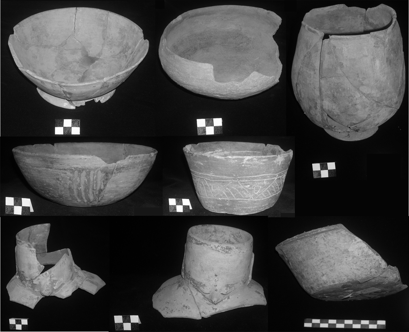
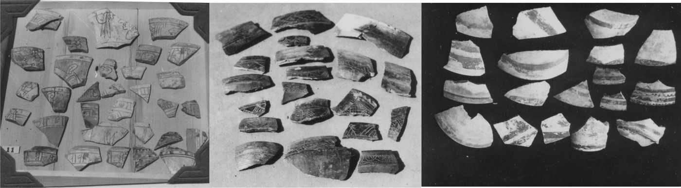
As expected, local ceramic types were strongly represented in the monumental center assemblage, including both serving and storage vessels. Locally produced ceramic vessels dominated most household assemblages and, as discussed above, constituted 65.9% of the monumental center ceramic assemblage compared to 88% in the residential zone of the site (Paris Reference Paris2012). Local types were particularly dominant in residential spaces such as Terraces 1 and 3, but were also strongly represented at Structures C and D. The most common local types include: Moxviquil Black, a Late Classic period decorated serving ware (Figure 13); San Gregorio Coarse, an Early Postclassic period unslipped storage and cooking ware; and Pinar Fine, an Early Postclassic period monochrome slipped ware used for small, plain jars and bowls (Culbert Reference Culbert1965; Paris Reference Paris2012). San Gregorio Coarse is pervasive throughout highland Chiapas during the Early Postclassic period, and has even been found in Early Postclassic deposits at Tonina, along with Huistan Hard, suggesting that it was widely produced and/or distributed (Culbert Reference Culbert1965; Taladoire Reference Taladoire2011). The monumental center also included small amounts of other local Jovel Valley types including Cerrillo Fine, Huitepec Red, and La Hermita Coarse (Culbert Reference Culbert1965; Paris Reference Paris2012). Several other Early and Late Postclassic highland Chiapas types identified by Culbert (Reference Culbert1965) were represented at Moxviquil and Huitepec in small proportions. These include Ixtapa Fine, an Early Postclassic trade ware thought to be manufactured in the Ixtapa Valley (McVicker Reference McVicker1969:34), and other types that were likely produced in the eastern Chiapas highlands, including Late Classic type Yerba Buena Fine: Yerba Buena Variety; Early Postclassic types Ecatepec Red: Ecàtepec Variety and Tzaconeja Red: Variety Unspecified (Culbert Reference Culbert1965:67–68); and Late Postclassic type Huistan Hard: Huistan Variety (Culbert Reference Culbert1965:72). These types were found predominantly on Terrace 3 of the monumental center.
Ceramics from Moxviquil. Provincia Plano-Relief sherds from Location E, Terrace 3 and other contexts (left), Moxviquil Black: Moxviquil Variety sherds from Location E and other contexts (center), and bichrome wares, possibly from the Southern Pyramid of the Upper Plaza (right). Photos by Clarence Weiant. Reproduced with permission from the Asociación Cultural de Na Bolom.

Many vessels from Moxviquil show a strong connection to the Upper Grijalva River Valley. Two of the whole vessels from Tomb 2 and Cache 2 were dishes belong to the Late Classic period type Pues Pseudo-glyph: Pues Variety. Sixteen other sherds of this type and form were also recovered from Terrace 2. Four other sherds from Terrace 3 and unknown contexts had slightly coarser gray paste and unpolished surfaces, suggesting that they are local imitations of this regional trade ware. Other vessels in the collection from this region include a Palek Polychrome: Palek Variety dish, a Middle Classic period type (Bryant et al. Reference Bryant, Clark and Cheetham2005:410), and a small orange-slipped jar with a human effigy face modeled on each side found in the Western Pyramid resembling Chax Modeled: Chax Variety (Bryant et al. Reference Bryant, Clark and Cheetham2005:Figure 9.111 l-m, 572). Twenty sherds belong to Chanal Modeled-carved: Chanal Variety (Bryant et al. Reference Bryant, Clark and Cheetham2005:485), a transitional Late Classic to Early Postclassic type also found at Yerba Buena (Bryant Reference Bryant, Bryant, Calnek, Lee and Hayden.1988:Figure 34a) and Rancho San Nicolas (Culbert Reference Culbert1965:Figure 6a), that represents a locally produced imitation of lowland types Pabellon Modeled-carved and Altar Orange: Altar Variety (Bryant et al. Reference Bryant, Clark and Cheetham2005:509). Other ceramics from the Upper Grijalva River Valley found at Moxviquil include Yerba Buena Fine: Pajuil Variety, Batzi Specular Red-on-Unslipped: Batzi Variety, San Sebastian Fine: San Sebastian Variety, and Tasajo Red: Tasajo Variety (Bryant et al. Reference Bryant, Clark and Cheetham2005).
The interregional Fine Orange trade wares at Moxviquil, which include Balancan (Z) and Silho (X) Fine Orange, span the end of the Late Classic and the entire Terminal Classic (Smith Reference Smith1958), suggesting that Moxviquil maintained exchange relationships with the Gulf Coast region that spanned multiple stylistic periods (Figure 13). Many of the Balancan Fine Orange dishes in the Moxviquil collection are examples of the incised variety Provincia Plano-Relief, and were likely imported to the Jovel Valley. Ongoing instrumental neutron activation analysis (INAA) in collaboration with Ronald Bishop of the Smithsonian Instiution will empirically test their provenience. McVicker (Reference McVicker1969) has argued that imitations of Balancan Fine Orange wares were produced in the Ixtapa Valley in several varieties. Of these, the Ixtapa Variety and Buff Variety are represented in the Moxviquil collection. The Ixtapa Fine Orange wares exhibit fine pastes, but their pastes are softer and chalky, with highly eroded slips, and incised designs that are less intricate or precisely executed than the high-quality Provincia Plano-Relief vessels found at Moxviquil. Ixtapa Fine vessels were widely distributed throughout highland Chiapas during the Early Postclassic period (Culbert Reference Culbert1965). Other ceramic types from the Ixtapa Valley were also recovered from the Moxviquil monumental center. Tomb 3 contained a large annular base dish belonging to Tortuga Red-on-Buff: Tortuga Variety, one outcurving bowl of the type Ixtapa Orange: Ixtapa Variety was recovered from Cache 3, and a sherd of Los Cocos Polychrome: Los Cocos Variety was recovered from Terrace 3—all three are Late Classic types.
Several vessels at Moxviquil exhibit negative painting, which is strongly identified with two regions of the Maya lowlands: Piedras Negras, along the Usumacinta River, and the Chama region in Alta Verapaz, although it is also found in the western highlands of Guatemala and the Peten (Smith Reference Smith1955:59). The most distinctive vessel exhibiting this technique is a complete cylindrical vase from Cache 2 (see Figure 6). The black-on-white geometric design that characterizes the Cache 2 vase, as well as most of the sherds described by Weiant, is more similar to the Chama style of negative painting, which favors black-on-white designs. Its red rim band, however, is a common element of Piedras Negras designs, which often have a red background (Butler Reference Butler, Weeks, Hill and Golden2005). The Cache 2 vase is also coated with a thin layer of stucco painted in dark red and green designs, a technique with only one other known example in the Chiapas highlands: a cylindrical vase of similar size, interred in a ballcourt central cache at Rancho San Nicolas (Culbert Reference Culbert1965:14). This technique of coating vessels with painted stucco has been noted at Palenque (Culbert Reference Culbert1965:14) and at Uaxactun, where it occurs in the Late Classic period (Smith Reference Smith1955:54).
A number of vessels in the collection remain unidentified, constituting 14.8% of the collection. These vessels are either unique or have been recovered in such small quantities that they could not be established as, or affiliated with, a type. Of these, 11.1% were fine serving ware bichromes (Figure 13) and trichromes described by Weiant in a wide variety of color combinations, including black, brown, orange, red, grey, buff, cream, and white, and many were documented in excavation photographs. Nearly all of these vessels, however, are absent from the collection at the Museo Na Bolom. In addition to the Balancan and Silho Fine Orange Ware types, a number of undesignated Fine Orange vessels were also present in the Moxviquil collection. Many of these were recovered from tombs and caches. Cache 1 included a tripod dish with round rattle feet, while Cache 2 included a cylindrical vase with incised geometric designs, and it is likely that they were both imported from an unknown source. The cylindrical vase from Tomb 5 (see Figure 8) is also an unidentified type of Fine Orange, and contains incised decoration with a repeating geometric band containing a repeating glyph. Due to erosion of the vessel, the glyph is partially illegible, but contains a yu prefix above what may be an imix sign, and a cloud scroll element above an unknown element (John Justeson, personal communication 2009).
The number and variety of nonlocal ceramic vessels in the Moxviquil monumental center suggest that they were obtained through long-distance exchange. Many vessels were obtained through exchange across political boundaries and, in some cases, linguistic boundaries. Monumental center residents obtained interregional trade goods such as Fine Orange wares from the Gulf Coast and Tohil Plumbate from the Soconusco, potentially through traveling merchants. They could have obtained local ceramic types from potters in the surrounding communities and nearby sites, either from vendors in the marketplace, or as part of tax/tribute payments. A small marketplace could have been hosted in either the Main Plaza or on the small plain nearby, where it would have served both monumental center residents, members of the surrounding community, and a variety of local vendors and long-distance merchants.
A consistent pattern among all of the imported vessels present in the Moxviquil ceramic assemblage is that the majority of types are from areas to the north or east of the Jovel Valley. It is notable that few vessels from the Moxviquil monumental center were imported from non-Maya regions. A notable exception in the collection consists of seven sherds of Tohil Plumbate, a regional trade ware from the Soconusco that was exchanged throughout Mesoamerica during the Early Postclassic, and was exported to numerous Maya sites (Sabloff Reference Sabloff1975). This suggests that Moxviquil monumental center residents may have purchased imported ceramic vessels in a purposeful way, as part of a broader sphere of exchange relationships with other Maya highland and lowland polities.
God N Worship at Moxviquil
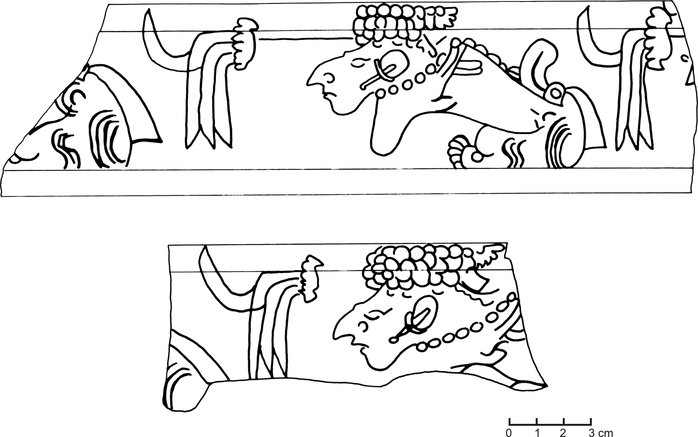
Many of the Provincia Plano-Relief vessels at Moxviquil are bowls and dishes incised with highly distinctive, identical motifs, one of which was an iconographic scene that may depict God N (Figure 14), an important Maya creator god closely associated with mountains and caves such as those that dominate the landscape surrounding Moxviquil. These motifs have not been documented at any other highland sites. The God N motif is associated with “Excavation E” and represented on two partially complete outflaring flat base dishes as well as on fourteen non-refitting sherds. The most complete vessel depicts two identical figures seated crosslegged in left profile, one on each side of the dish (Figure 14), wearing large earspools and a necklace, and with a distinctive headdress composed of small round elements, which may be a variant of the net bag headdress often worn by God N (Bassie-Sweet Reference Bassie-Sweet2002:25). The figure also has a prominent nose and chin and sunken cheeks likely depicting age, and wears a knotted loincloth. The arms of the figure appear to be crossed, but with exceptionally long fingers wrapping around the back of the figure, perhaps denoting the process of transforming into a bird. In front of the figure is a lobed element with feathers dangling from it, also a common motif associated with God N figures on polychrome vases. The other 14 non-refitting sherds in the collection each contain elements of this scene. The vessel forms, paste, white slip, method of incising, and composition of the scenes are identical, yet each example contains tiny variations, such as the slant of the eyes, the angle of the chin, the angle of the earspool, or the number of round elements in the headdress. This suggests that multiple artists could have copied the scene from a template, either at the same time for a single event, or for a reoccurring event over a period of years. To date, these vessels have not been reported at any other sites in highland Chiapas, nor are they found in the residential portions of Moxviquil (Paris Reference Paris2012).
Drawing of the God N motif on two non-refitting Provincia Plano-Relief: Variety Unspecified outflaring dishes from Moxviquil. Drawing by Elizabeth Paris.

In some versions of Maya cosmology, God N is an old creator deity who is closely related to, or a particular aspect of, Itzamnah (Bassie-Sweet Reference Bassie-Sweet2002:25). In Classic period Maya art, God N is a grandfather deity who was thought to be the embodiment of the mountain (Bassie-Sweet Reference Bassie-Sweet2002:6), often depicted with almond-shaped eyes, and denoted by the glyphs T1014 (portrait), T64 (which depicts his net bag headdress, often associated with the numbers 3, 4, and 5), and T528 (the wooden drum tuun conflated with the net bag headdress) (Bassie-Sweet Reference Bassie-Sweet2002:25). Access to the mountain homes of God N was through cave openings located at the cardinal directions. Through these openings, beneficial and destructive forces could enter the world, including beneficial winds that fanned the fires of the milpa, and harmful winds that caused diseases. Caves are seen as a source of both rain and pure stream water, and are considered to be the home of the Chaaks, celestial spirits that inhabit the caves and cause lightening and rain (Bassie-Sweet Reference Bassie-Sweet2002:15).
Another vessel type at Moxviquil also has potential links to God N. Thirty-five vessels were long-necked jars with crudely model-carved opossum faces on the necks. Twenty-five of these vessels had slightly outsloping necks, one had an outflaring neck, and the rest were neck fragments. Twenty-six of the vessels were classified as Yerba Buena Fine: Polychrome Variety, and had painted decoration in red, orange, black and white; seven were Pinar Fine, divided among the Las Piedrecitas, Pinar, and Unslipped Varieties; and a single example belonged to Huitepec Red: Huitepec Variety, an unusual example with paste that was far more coarse than the other examples. Two of these vessels were recovered from Cache 3, while a third is also present in Blom's photos, although it was not found in the Museo Na Bolom ceramic collections (see Paris Reference Paris2012:Figure 5.23). Two identical opossum vessels belonging to the type Yerba Buena Fine: Polychrome Variety were recovered from an elite house at Yerba Buena (Bryant Reference Bryant, Bryant, Calnek, Lee and Hayden.1988:55, Figure 29h-j), although to date they have not been recorded at any other sites in the Chiapas highlands or elsewhere. This limited distribution of forms, combined with the use of local ceramic paste types, suggest that these opossum jars could have been produced at Moxviquil, likely during both the Late Classic and Early Postclassic periods.
The opossum vessels may also be associated with God N, since God N was one manifestation of the Bakabs, also referred to as Pauahtuns (Bassie-Sweet Reference Bassie-Sweet2002:30). According to de Landa, the Bakabs were four brothers placed by God at the creation of the world at the four corners of the sky to hold it up (Tozzer Reference Tozzer1941:136). The mountain manifestations of the Bakabs could also take the form of opossums, and they ruled the darkness before dawn (Bassie-Sweet Reference Bassie-Sweet2002:36). The Bakabs are often depicted as opossums in Maya art. For example, the Dresden Codex depicts one of the Bakabs in New Year's celebration (Thompson Reference Thompson1974). Bassie-Sweet (Reference Bassie-Sweet2002:31) claims that:
“The manner in which the grandfather possum is addressed in the Popol Vuh suggests that the reading of the God N portrait may simply be “old man.” The possum is called mam “grandfather,” but he is also addressed as ama “old man.” This is also the term used for males in general. There is a similar term in Tzotzil; the term mool is glossed in a colonial period dictionary as “old man” (Laughlin Reference Laughlin and Haviland1988:260, personal communication). When used as an adjective, the contemporary Tzotzil term mol means old or large, but when used as a noun it means elder, husband or man (Laughlin Reference Laughlin1975:239). It is the term used for old men in general and for the highest ranking elders in the religious hierarchy (Vogt 1976:254).”
Thus, she concludes, one of the titles of God N would be “Old Man Possum” (Bassie-Sweet Reference Bassie-Sweet2002: 31).
The close association between God N, depicted both in anthropomorphic form and as an opossum, on a total of 48 vessels from the Moxviquil ceremonial center, combined with the clear association of the center with mountains and caves, suggests that the center may have a special connection with God N, commemorated through special-purpose ceramic vessels. The presence of two opossum jars at Yerba Buena suggests that nearby centers may also have participated in these rituals, or may have hosted their own.
God N is also one of many deities associated with thunder (Taube Reference Taube1992). Ironically, Moxviquil ceramics also represent God K or K'awiil, one of the many gods associated with lightning. K'awiil is depicted on a Silho Fine Orange vase found at Cache 1 in the ceremonial center of Moxviquil (Figure 10). The vase depicts K'awiil with the classic axe in his forehead, in a kneeling position, with speech or wind scrolls emitting from his mouth, and a cross-hatched rectangle under his arm, which may be a woven mat. He wears a large feather headdress, a large earspool, bracelets, and a large beaded collar. K'awiil's face and the speech/wind scrolls emerging from his mouth are partially covered in small crosshatched patches, a motif often linked to God N and the sign akbal or “darkness” (Bassie-Sweet Reference Bassie-Sweet2002:34). This combination of deities representing lightning, thunder, and wind, may represent thunderstorms, a common meteorological phenomenon in highland Chiapas, and one that could either bring rain to crops, or kill via lightning strikes or floods. The vessels depicting God N and K'awiil may have been used in rituals which drew on the associations of these powerful deities with various aspects of the highland Chiapas landscape—mountains, caves, and thunderstorms. While the production location of these vessels is unknown, they may have been produced specifically for ritual purposes related to God N and K'awiil.
DIVERSIFIED PRODUCTION ACTIVITIES IN THE MOXVIQUIL MONUMENTAL CENTER
The Moxviquil monumental center was a locus for craft production activities, many of which were related to cloth production (spinning and weaving), chipped stone tool production (chert projectile points and obsidian blades), and stone or wood carving. Many craft production activities appear to have been concentrated in the residential terrace zone, particularly on Terrace 3. The majority of production activities were likely low-intensity and small-scale, and probably took place internally within households; larger-scale lithic tool production could have been organized for external exchange. Many of these craft production activities utilized nonlocal materials such as obsidian, cotton, and maguey, although producers also drew on local materials such as chert, and created production implements from recycled local ceramic sherds and deer antler tines. Food processing and preparation also took place within the monumental center itself.
Cloth Production
Blom and Weiant's excavations recovered several ceramic spindle whorls at the Moxviquil monumental center, suggesting that cloth production may have been an important activity for some of its residents (Figure 15). A photograph of spindle whorls among Weiant's documents includes 20 whorls—11 large and nine small. Eight of these spindle whorls are among the 16 examples on display at Na Bolom, but the location of the remaining whorls in the photograph is currently unknown. Weiant also sketched two spindle whorls in his ceramic notebook, both from Location D. Five additional spindle whorls are present in a photograph with a ceramic censer fragment still present at the Museo Na Bolom, in a bag of ceramics from Terrace 3. This suggests that these five spindle whorls are also from Terrace 3, and that they were associated with the residential structures on that terrace. The majority of the spindle whorls in Weiant's photos appear to be recycled from ceramic sherds, with the exception of five that have incised or stamped decoration, which were likely modeled and then decorated. They range widely in size from 2.4 to 7.5 cm in diameter. In addition to the ceramic examples, two small spindle whorls were carved from skull fragments. We speculate that spindle whorls made from bone may have had a distinctive function, such as spinning thread for cloth used for specific ritual purposes.
Spindle whorls from Terrace 3 (left) and unknown contexts (right) at the Moxviquil monumental center. Photos by Frans Blom. Reproduced with permission from the Asociación Cultural de Na Bolom.

Ceramic stamps could have been used to create designs on cloth, as well as paper, and/or ceramics, although they may also have been used in human body decoration. Weiant illustrated one stamp from the surface collections of Terrace 3 (see Figure 11) and a second example was found in the bodega ceramic collections from Terrace 3. Weiant's stamp was made of “coarseware” (local ceramic types San Gregorio Coarse, Huitepec Red, or La Hermita Coarse are likely candidates), while the stamp analyzed by Paris matches the paste characteristics of Cerrillo Fine: Cerrillo Variety, a tan/orange fine-textured ware with fine sand temper locally produced in or near the Jovel Valley (Paris Reference Paris2012).
A small number of bone artifacts in the collection were likely associated with other aspects of cloth production. Two artifacts appear to represent sewing implements, including a turkey bone awl and a white-tailed deer metapodial awl (Figure 15). The collection also includes four modified large mammal long-bone shafts, which have been carved into long, thin implements that could have been used as weaving tools.
Spinning, weaving, sewing, and stamping decoration suggest that cloth production was a small-scale activity for residents of the monumental center, but one with high social visibility, which would have emphasized their participation in exchange networks. The variation in sizes of the spindle whorls suggests that residents spun both cotton and maguey fibers. Neither cotton nor maguey is indigenous to the highlands. While modern farmers successfully grow maguey plants in small quantities near the Jovel Valley today, it is uncertain if this practice is recent or was also common in pre-Columbian times. Cotton will not grow in the Jovel Valley due to the climate and altitude. It was, however, grown at the time of Spanish contact at slightly lower elevations in the Central Depression and Copanaguastla (Calnek Reference Calnek, Bryant, Calnek, Lee and Hayden1988:15; Ximénez Reference Ximénez1929). The residents of Moxviquil could have imported cotton and maguey fibers from either of these areas, using it to produce garments and other items of decorated cloth. These items would likely have emphasized the connections of the wearer to long-distance trade networks, and displayed the spinning, weaving, and sewing skills of the producers. Because many of the spindle whorls and stamps were recovered from Terrace 3, cloth production may have been particularly associated with these residential spaces.
Chert Chipped Stone Tool Production
The lithic artifacts from the monumental center of Moxviquil represent both chert and obsidian tool industries, including obsidian blade production and chert projectile point production. Of all these production activities, chert projectile point production is the most completely documented by Blom and Weiant. The chert artifacts from the monumental center of Moxviquil suggest that its residents produced and consumed items from local raw materials, and also imported exotic lithic commodities. Evidence suggests that chert tool production activities took place within the monumental center itself, while other production activities took place at nearby high-quality, fine-grained chert sources nearby. Other formal projectile points may have been imported from other sites in the Maya lowlands.
Excavations on Terrace 3 suggest that residents on this terrace likely engaged in chert projectile point production. Blom and Weiant recovered “hundreds” of chert projectile points in multiple sizes and styles, chert nodules, partially modified flakes, production rejects, debitage flakes, and antler tines, all in association with low masonry walls interpreted as the foundations of pole-and-thatch residential structures (Weiant Reference Weiant1954a). Blom described the context as large workshop and arsenal, whose products were sought by hunters and warriors from miles around (Weiant Reference Weiant1954a:32). Notably, evidence of small-scale projectile point production was also recovered at outlying Moxviquil households, suggesting that projectile point production at the monumental center was not organized to supply outlying residential zones, but was organized around internal use by other monumental center residents and/or for external exchange.
The collection of chert artifacts at the Museo Na Bolom includes 21 items from the monumental center attributed to the Terrace 3 excavations (Figure 16, Table 4), and 133 artifacts from the Piedritas del Fuego source. This likely represents a small proportion of the original collection excavated by Blom and Weiant, but the remainder has not been located to date. Of the current sample, 18 of 21 artifacts are projectile points representing a wide variety of styles (Table 4). The most common type is a triangular projectile point, basal-notched, with a tapered stem and pointed base (n = 5), while the second most common is a non-fluted lanceolate point with a concave base (n = 4). The points vary widely in the degree of skill used to execute production, ranging from thin, finely crafted spear points to thick, crude arrow or dart points which may represent preforms or practice pieces. Of the production tools and debitage, only three artifacts remain in the Museo Na Bolom collection: a second series blade, a small tertiary flake, and a small bifacial flake core. These artifacts could possibly have been part of projectile point production, but could have also been used to create other tool types such as knives, scrapers, or drills similar to those found in the outlying residential zone of Moxviquil (Paris Reference Paris2012).
Chert artifacts from the Moxviquil monumental center, on display at the Museo Na Bolom. Photos by Elizabeth Paris.

Chert artifacts from the Moxviquil monumental center (from the Museo Na Bolom)

Chert tool producers from the monumental center of Moxviquil likely took advantage of abundant raw material from nearby sources. Blom attributed the source of the Moxviquil chert artifacts to the “Piedritas del Fuego” site, located 1.5 km from Moxviquil, and also noted the presence of another equidistant chert deposit to the northeast (Blom Reference Blom1953c; Brunhouse Reference Brunhouse1976:221; Evening Star 1954; Weiant Reference Weiant1954a). Blom collected a variety of artifacts from Piedritas del Fuego at an unknown date, reflecting early-stage tool production activities. The majority of artifacts from this site were made from fine-grained, high-quality chert with few inclusions, varying in color from tan to gray. A small proportion (12.7%) of these artifacts was made from medium-grained chert, quartz-chert blend, or limestone in the same range of colors. The assemblage includes a wide variety of tools, preforms, cores, and debitage (Table 5) associated with production of bifacial and unifacial cutting tools. Tool types include thin, evenly flaked small bifaces, and preforms for projectile points, bifacial knives, and unifacial scrapers. Production-related artifacts include polyhedral flaked cores (n = 3) and 90 flakes, including large primary core preparation flakes, secondary and tertiary flakes, and bifacial thinning flakes. Several artifacts are associated with chert blade production. The collection included a crude blade core, percussion blades likely generated from producing the polyhedral blade cores, and first, second, and third series blades. Producers at this quarry site may have exported cores, preforms, and finished tools to the monumental center.
Chert artifacts from the Piedritas del Fuego quarry, located by Frans Blom at 1.5 km from the Moxviquil monumental center (from the Museo Na Bolom)

The possibility remains, however, that not all of the projectile points from the Moxviquil monumental center are of local origin. The blade, flake, core, and 10 of the projectile points were light gray to grayish-brown in color, similar to the artifacts from the Piedritas del Fuego source, while the other eight points were brown to dark brown, from an unidentified source. In particular, three large spear points and two mid-sized points are larger, thinner, and more finely worked than the rest of the sample (Figure 16). They are also stylistically distinct from the rest of the collection, as well as from the small, thick dart points recorded by Clark (Reference Clark, Bryant, Calnek, Lee and Hayden1988) at Yerba Buena. Instead, their forms suggest similarities to projectile point styles recovered from Late Classic period sites in the Maya lowlands such as Piedras Negras (Hruby Reference Hruby2006:Figure 5.2), Cancuen (Kovacevich Reference Kovacevich2006:Figures 8.34, 8.56, 8.57, 8.61), and Yaxchilan (Kaneko Reference Kaneko2003:Figures 24, 27), among others. They were most likely imported from Maya lowland sites, although this remains to be verified through provenience studies.
Obsidian Prismatic Blade Production
The residents of the Moxviquil monumental center also imported obsidian prismatic blades and prismatic blade cores from highland Guatemala. Of the 84 obsidian artifacts in the Museo Na Bolom display collection (Figure 17), 75 are small third-series (prismatic) blades, which were used as cutting implements. The collection also includes a single second-series blade, seven exhausted polyhedral blade cores, and a single small bifacial flake core—the exact provenience of these items is unknown. Photographs and Weiant's ceramic notebook can be used to locate one blade from Cache 1, one blade from Location D, and six blades from Terrace 3, but the excavation contexts of the blade cores remains undocumented. Two obsidian artifacts were also recovered at the Piedritas del Fuego chert quarry, including a prismatic blade and a small flake core fragment. No obsidian debitage flakes remain in the Museo Na Bolom collection, although Weiant (Reference Weiant1954a) noted the presence of obsidian flakes on the surface of Terrace 2.
Obsidian artifacts from the Moxviquil monumental center, on display at the Museo Na Bolom. Photos by Elizabeth Paris.

Prismatic blades have been produced at Moxviquil itself, although some of them may also have been imported as finished objects. The prismatic blade cores had undergone extensive third-series reduction by the time they arrived at Moxviquil, and were very small and thin, with small platforms and thin blade scars. This suggests that a highly skilled producer used them to create blades and exhausted them to the fullest extent possible. The third-series prismatic blades in the collection consist of fragments, including 35 medial segments, but also including 28 proximal segments and 12 distal segments. As such, this does not preclude the possibility that at least some blades were produced on-site. Most of the blade segments are relatively small and thin, ranging between 2 and 5 cm in width, with a mean length of 3.6 cm, suggesting that they were produced from highly reduced prismatic blade cores. Obsidian cores have not been recovered from any other excavated areas at Moxviquil, suggesting that obsidian production may have been associated exclusively with the monumental center; however, obsidian prismatic blades were found in outlying residential areas of the site as well as in the monumental center (Paris Reference Paris2012). Based on visual sourcing, the majority of the blades and cores appear to be from the Guatemalan sources at El Chayal and San Martín Jilotepeque, while a few blades may be from central Mexican sources. This suggests that some prismatic blades from the monumental center may have been fabricated on-site by a high-skill producer, but that other blades were likely imported as finished items. Notably, El Chayal and San Martín Jilotepeque were the most common obsidian sources exchanged in trade networks along the Usumacinta River, and in many parts of Chiapas during the Classic period (Braswell Reference Braswell, Smith and Berdan2003:140).
Stone or Wood Carving
Many of the groundstone artifacts from the Moxviquil monumental center may reflect stone or wood cutting or carving activities. The sample of groundstone artifacts from the monumental center (n = 40) included many axes and other chopping and hammering tools, including both groundstone axes (n = 25) and greenstone axes (n = 14). Unfortunately, most of the artifacts cannot be linked to specific excavated contexts, but several groundstone axes appear in Weiant's photographs from Terrace 3 (see Figure 11).
Most groundstone axes were made of basalt, while others were made from other types of mafic or felsic igneous rocks. Similar groundstone artifacts include a chisel, a hammerstone, and a weight likely used in architectural construction. Although no quarry sites have yet been located, numerous igneous stone sources exist in highland Chiapas, including nearby dormant volcanoes such as the Volcán de Huitepec on the southwestern edge of the Jovel Valley, and Tzontehuitz (a volcanic dome complex) to the north. A single miniature celt in the collection was made from fine-grained limestone, which could have been obtained from outcrops that exist throughout the Jovel Valley. Greenstone artifacts (mostly serpentine and olivine) in the Moxviquil collection included a miniature axe, a polished biface, and a polished pebble. Highland Chiapas also contains several sources of greenstone, including Huixtan to the east and Chalchihuitan to the north (Paris Reference Paris2012).
One possible product of carving activities could be the small sculpture fragments documented in photographs by Blom and Weiant, which include a cylindrical fragment in the photo of artifacts from Terrace 3 (Figure 11), two fragments of stone sculpture with anthropomorphic faces photographed in association with groundstone metates (Figure 18), a small round sculpture with carved curvilinear designs, six rounded sculpture fragments, and a small eroded square block with a carved square face (possibly anthropomorphic or zoomorphic). Two sculpture fragments illustrated in the Instituto Nacional de Antropología e Historia report (Blom and Weiant Reference Blom and Weiant1954), a jaguar and a human head recovered from the Southern Pyramid in the Upper Plaza, exhibited a slightly higher degree of workmanship, and may also have been locally manufactured.
Groundstone manos and metates from unknown contexts, Moxviquil. Photos by Frans Blom and Clarence Weiant. Reproduced with permission from the Asociación Cultural de Na Bolom.

Food Processing and Preparation
Several groundstone artifacts in the Na Bolom collection were connected with food production (Figure 18). Among these are two groundstone manos and four metates, including a miniature tripod metate that may have been used for finer food materials such as seeds or pigments, and two decorated metates, one with a human effigy leg, and one with a snake head at the distal end. According to Weiant (Reference Weiant1954a), most grinding implements were recovered on Terrace 3, with the notable exception of the large mano among the offerings from Tomb 3 (Blom and Weiant Reference Blom and Weiant1954). Weiant notes that excavations on Terrace 3 recovered “any number of grindstones with their manos” (Weiant Reference Weiant1954a).
Photographs from the Museo Na Bolom archives suggest that a total of eight manos and 12 metates were excavated from the monumental center, and that the present collections do not include the entire sample (Figure 18). A photograph of artifacts from Terrace 3 includes three groundstone axes and a groundstone mano (Figure 11), while five other photographs (Figure 18) depict six manos and 12 metates within the monumental center. An additional mano was found among the offerings in Tomb 3 (Figure 4). Metates ranged in size and elaboration and included large, flat metates, tripod metates (large and miniature), and zoomorphic metates. Examples of the latter two styles bear a strong resemblance to examples from Yaxchilan (Kaneko Reference Kaneko2003:Figures 50 and 51). Weiant's notes (Reference Weiant1954a) also document the presence of two metates, “one large and one small,” in Tomb 2. This suggests that food preparation was an important activity in the monumental center. It seems unlikely that members of the elite performed this labor-intensive activity but, rather, it may have been performed by lower-ranking individuals on behalf of high-ranking households. The presence of a mano in Tomb 3 and two metates in Tomb 2 suggests that these food preparation implements also played a symbolic role in mortuary rituals.
Several of the metates, however, may have functions related to pottery production rather than food production or processing. According to Weiant (Reference Weiant1954a:33), “[w]e found the grindstones to be of two types, one rather smooth and finely made, the other coarse and pitted. We wondered about the significance of this, until one of the workmen said he wished he had one of the coarse ones. This is the type the modern Indian women like to use, not to grind corn, but to prepare clay for pottery making.” No kilns or other firing features were documented at the Moxviquil monumental center; however, this potentially hazardous activity may have been spatially removed from the crowded residential terraces.
CURRENCY, ORNAMENTS, AND COMMODITIES AT MOXVIQUIL
The wide variety of personal ornaments, currencies, and commodities recovered from the Moxviquil monumental center also emphasizes the role of its residents as consumers of interregional commodities, and suggests that the monumental center may have hosted a marketplace for both local vendors and long-distance merchants. In addition to nonlocal ceramics, many other exotic commodities were recovered from the monumental center, including greenstone, marine shell, metal, and lowland animal products. Cache 1 contained many items that were likely imported through exchange with the lowlands, including two jaguar fangs, two peccary tusks, and two bone crescent-shaped atlatl fingerloops (Figure 10). Other artifacts in the collection suggest that the inhabitants of the monumental center were using (or at least receiving) types of currencies that were widely used throughout the Maya region. Carved olive shell tinklers, jade beads, and copper axes are among the many currencies recorded in the northern Yucatan at contact (Tozzer Reference Tozzer1941), and several scholars (Freidel et al. Reference Freidel, Reese-Taylor, Mora-Marín, Masson and Freidel2002; Masson and Freidel Reference Masson and Freidel2012; Paris and Peraza Lope Reference Paris, Lope, Simmons and Shugar2013) have argued that these currencies were important media of exchange in Classic and Postclassic period commercial exchange systems. Offerings in Tomb 3 included five olive shells, which had been modified by sawing the tip off the shell, and carving or punching holes in the bodies of the shells (Figure 4). A small jadeite bead was discovered in Structure B, although it is no longer present in the collection (Weiant Reference Weiant1954a). A small copper axe labeled with a Moxviquil provenience was included in the display collection, although it is not mentioned in the documents or photos. Several other unprovenienced metal artifacts in the collection include a second small axe, a copper axe-money of the type common in Postclassic period Oaxaca and Guerrero (Type VIIIA) (Pendergast Reference Pendergast1962), and two copper earspools. The presence of these items at Moxviquil suggests that its elite residents were engaged in long-distance exchange networks, and obtained interregionally circulating currencies and ornaments in exchange for local commodities.
Two groundstone artifacts in the collection suggest long-distance exchange between Moxviquil and the residents of the Gulf Coast. These include a large basalt ballgame yoke (Figure 19) and an hacha depicting a human face (Figure 3). Both items are stylistically associated with the yoke-hacha-palma complex of the Gulf Coast of Veracruz. The large basalt yoke may have been associated with the I-shaped ballcourt, but its excavated context within the monumental center was not recorded. The limestone Totonac hacha was recovered from the fill of the Western Pyramid (Weiant Reference Weiant1954a), and is likely also an import from the Gulf Coast of Veracruz. Edwin M. Shook recorded a second hacha fragment in the Othon Schlie Collection in San Cristóbal de las Casas in 1951, of unknown provenience (Shook and Marquis Reference Shook and Marquis1996, Number H65).
Groundstone Totonac basalt yugo (ballgame yoke), likely from the Moxviquil monumental center, and on display at the Museo Na Bolom. Photo by Elizabeth Paris.

DISCUSSION
Moxviquil was likely one of the principal locations of settlement in the Jovel Valley during the Late Classic and Early Postclassic period and, we argue, was a diversified center which served political, economic, and ritual functions for the surrounding population, and was also an important nucleus of residential settlement and household-based production activities. In contrast to the large, powerful cities of the Maya lowlands (including large midland sites such as Tenam Puente and Chinkultic), Late Classic-Early Postclassic period highland Chiapas was a decentralized, heterogeneous landscape of small polities, ruled from small hilltop cities such as Moxviquil, Ecatepec, La Tortuga, Yerba Buena, Rancho San Nicolas, and San Gregorio. The small size and defensive locations of these sites led Adams (Reference Adams1961) and Culbert (Reference Culbert1965) to characterize these highland polities as being mutually hostile, with “fairly isolated pockets of intense settlement with each site maintaining its own intensive position” and “no evidence in ceramics of a significant penetration of the region by groups involved in interregional trading relationships” (Adams Reference Adams1961:348). The regional context is critical; rather than becoming highly specialized around a single resource or activity set, Moxviquil and other small monumental centers of highland Chiapas likely served as the political capitals of small, independent polities, and thus had to fulfill a wide variety of urban functions for those polities. Despite its defensive hilltop location, the residents of the Moxviquil monumental center maintained economic ties with a large network of other small polities throughout highland Chiapas and also utilized commodities and ideas from larger lowland Maya polities such as Tonina, sites on the Gulf Coast, the Upper Grijalva River Valley, and highland Guatemala.
Despite their small size, Moxviquil and other highland monumental centers fulfilled a wide range of political, economic, social and religious functions for their surrounding hinterlands, functions that are cross-culturally associated with cities (Fox Reference Fox1977; Sjoberg Reference Sjoberg1960; Smith Reference Smith1989, Reference Smith, Schwartz and Falconer1994, Reference Smith, Gmelch, Kemper and Zenner2002; Trigger Reference Trigger2003). These functions are reflected in the architectural diversity of the monumental center, which included temples, platforms, a ballcourt, the administrative “Western Pyramid,” the ruling family residences of the Upper Plaza, the large public Main Plaza, where events may have ranged from political and religious rituals to a periodic marketplace, and the monumental center also contained an important residential zone on the hillside terraces. The residential terraces, particularly Terrace 3, contained evidence for a wide range of production activities. With the possible exception of chert tool production on Terrace 3, most of these activities appeared to be craft activities by and for the monumental center residents themselves, including spinning, weaving, obsidian blade production, and wood and stone working. The number and variety of manos and metates suggest the importance of maize processing at the monumental center. The number of decorated bowls, dishes, tripod dishes, and cylindrical vases, however, suggest that maize processing was likely related not only to daily food consumption, but possibly feasting events among the monumental center's elite residents as well. Other metates could have been used for ceramic vessel production, as originally suggested by Weiant (Reference Weiant1954a).
Moxviquil was an active participant in local, regional, and interregional exchange networks, particularly emphasizing relationships with its lowland Maya counterparts. Locally, its ceramic assemblages are closely tied to those of Ecatepec (Culbert Reference Culbert1965) and Huitepec (Paris Reference Paris2012) to the west, and to sites in the Amatenango Valley such as Yerba Buena and Rancho San Nicolas, and with the site of San Gregorio to the northeast (Bryant Reference Bryant, Bryant, Calnek, Lee and Hayden.1988; Culbert Reference Culbert1965). The commonalities in ceramic assemblages across a large and geographically diverse region are suggestive of interaction rather than isolation. At the regional level, Moxviquil maintained exchange relationships with the Valley of Ixtapa, the Upper Grijalva River Valley, the Gulf Coast, and highland Guatemala, exchanging ceramics (and locally imitating foreign ceramic styles), obsidian blades and blade cores, Totonac sculptures, copper, shell tinkler currency, jadeite beads, and bone ornaments. This suggests that Moxviquil and the other small cities of highland Chiapas may have served as nodes in a “city system” similar to those proposed by Kowalewski (Reference Kowalewski1990) and Smith (Reference Smith2005). These centers could have hosted small and/or periodic markets that served their surrounding hinterlands and also attracted regional and long-distance traveling merchants. Items obtained through interregional exchange did not replace locally produced commodities such as ceramics, chert tools, animal products, and groundstone tools. Instead, they often complemented and stylistically informed local industries.
During the Early Postclassic period, Moxviquil may also have developed economic and cultural ties to the powerful Late Classic polity of Tonina. Two ceramic types from highland Chiapas are found at Tonina during the Early Postclassic, including San Gregorio Coarse: San Gregorio Variety and Huistan Hard: Huistan Variety (Taladoire Reference Taladoire2011). Culbert (Reference Culbert1965) also notes some similarities between Huistan Hard: Huistan Variety and ceramics from the site of Tzajalchib in the Ocosingo valley. Other ceramic types recovered from Ocosingo Valley sites from deposits dating to the end of the Ixim (Late Classic phase) and the Chenek (Early Postclassic) phases also suggest a close relationship between these two regions. These include ceramic types Chablekal Fine Gray, Provincia Plano-Relief, and Ucutsin Brown-on-Buff, as well as Balancan and Silho Fine Orange wares. Tonina also produced its own version of incised Balancan Fine Orange, named Caana White, found predominantly in mortuary contexts at the Late Classic-Early Postclassic period transition. Caana White has strong stylistic similarities to the Provincia Plano-Relief imitation vessels recovered at Moxviquil, although the subjects of the incised designs (which include the Tonina emblem glyph and depictions of captives) and the larger, more elaborate vessel forms are fairly distinctive between the two regions (Taladoire Reference Taladoire2011). Becquelin also notes stylistic similarities between some Laltic Orange Polychrome vessels and the Ixtapa Fine vessels recovered from Ecatepec reported by Culbert (Becquelin and Baudez Reference Becquelin and Baudez1979–1982).
Recent analysis of the occupation of the Ocosingo Valley (Taladoire Reference Taladoire2011) showed that, following Tonina's fall sometime after a.d. 909, the valley's inhabitants tried to rejuvenate its population and political structure. Toward this end, they started building new structures at Tonina itself, reused monuments in the walls of other structures, and inhabited the area until a.d. 1100 or later. These later settlements are predominantly located in the western part of the valley, on the fringes of the limestone plateau that forms the foothills of the Chiapas central highlands. It seems then that they established or reinforced former ties with a still undefined highland ally. Taladoire (Reference Taladoire2011) suggests that economic ties between Tonina and highland polities such as Moxviquil may help to explain Tonina's resistance to the sociopolitical collapse that occurred at many Maya sites in the nineth century a.d.
Moxviquil may also have had an important regional religious role related to the worship of God N. Two different vessel types, including dishes with incised God N motifs and long-necked jars with opossum effigy necks (Bakabs), were recovered from the monumental center. The God N dishes are most similar to Provincia Plano-Relief, one of the types of Balancan Fine Orange wares that were widely distributed throughout the Maya region during the Late or Terminal Classic period (a.d. 750–900) (Bishop Reference Bishop, Scott and Meyers1994; Bishop and Rands Reference Bishop, Rands and Sabloff1982). Smith's (Reference Smith1958:151) original study argues for a center of production in eastern Tabasco, possibly in the Jonuta-Tecolpan region, or in southwest Campeche near Los Guarixes. These vessels were widely exchanged and imitated, particularly at sites along the Usumacinta River and its tributes throughout eastern Chiapas and northwest Guatemala (Bishop Reference Bishop, Scott and Meyers1994). In contrast, most opossum effigy neck jars were made from local ceramic types such as Yerba Buena Fine: Polychrome Variety and Pinar Fine: Pinar Variety. These vessels and their designs could have been copied from templates by multiple artists, either at the same time for a single event, or for a reoccurring event over a period of years. Given the association of God N and the four Bakabs with mountains, caves and rain, it seems likely that Moxviquil may have had a special connection with God N, commemorated through rituals involving special-purpose ceramic vessels. The presence of two opossum jars at Yerba Buena (Bryant Reference Bryant, Bryant, Calnek, Lee and Hayden.1988:Figure 29h-j, 55) suggests that nearby centers may also have participated in these rituals, or may have hosted their own.
Moxviquil provides us with an important glimpse into the role of small cities in periphery regions such as highland Chiapas, as well as more broadly among the small polities of Mesoamerica. Its location may have been politically and economically peripheral to the powerful lowland Maya polities, yet its position within a network of small highland polities facilitated economic and cultural ties with highland and lowland areas to the east. Moxviquil also reminds us that as the monumental centers of Maya sites are imperiled through erosion, neglect, and looting (Esponda Jimeno Reference Esponda Jimeno1984), and it is often valuable, if not essential, to take a new look at old collections.
RESUMEN
Las excavaciones de Frans Blom y Clarence Weiant en el sitio arqueológico de Moxviquil en 1952–1953 constituyen un proyecto arqueológico pionero en los altos de Chiapas. Ubicado en el valle de Jovel, Moxviquil se encuentra en una región de contacto entre diversas áreas culturales. Los resultados de sus excavaciones, que fueron sólo mínimamente publicados, proporcionan datos importantes sobre uno de los sitios más significantes en esta zona, en el clásico tardío-posclásico temprano. En este trabajo, se reconsidera Moxviquil a través de estudios recientes sobre el urbanismo maya, y se ofrecen nuevas interpretaciones del sitio como una pequeña ciudad que cumple diversas funciones urbanas para los residentes, tanto dentro de la zona monumental, como para los ocupantes de las zonas residenciales alrededores. De acuerdo con su papel como centro administrativo de un pequeño reino independiente de los Altos de Chiapas, la zona monumental de Moxviquil probablemente desarrolló varias funciones políticas, económicas y rituales. También fue un importante núcleo de asentamiento residencial donde se concentró una amplia gama de actividades artesanales y preparación de alimentos.
A pesar de su tamaño reducido, en comparación con otros centros urbanos mayas, Moxviquil y sus contemporáneos de los altos de Chiapas cumplieron un amplio panel de funciones que se relacionan culturalmente con el concepto de ciudad, en una perspectiva emic (Fox Reference Fox1977; Sjoberg Reference Sjoberg1960; Smith Reference Smith1989, Reference Smith, Schwartz and Falconer1994, Reference Smith, Gmelch, Kemper and Zenner2002; Trigger Reference Trigger2003). Se reflejan estas funciones en los diversos elementos arquitectónicos de la zona monumental, incluso los templos, el juego de pelota, la “Pirámide occidental”, la residencia de la familia gobernante de la Plaza Superior y de la Plaza Principal, en donde podrían haberse realizado eventos rituales, políticos y religiosos, o mercados periódicos. En las terrazas de las laderas del centro monumental, existía una importante zona residencial. Esas terrazas, en particular la Terraza 3, contenían pruebas de una amplia gama de actividades artesanales de producción, por y para los mismos residentes del centro monumental, incluyendo el hilado, tejeduría, producción de navajas de obsidiana y trabajo de madera o piedra. El número y la variedad de manos y metates sugieren la importancia del procesamiento de maíz, en el centro monumental. El número de cuencos, platos decorados, platos trípodes y vasijas cilíndricas sugiere que el procesamiento de maíz se relacionó no sólo con el consumo diario de alimentos, pero posiblemente también para las fiestas entre los residentes élites del centro monumental. Otros metates podrían haber sido utilizados para la producción de cerámica, una idea sugerida originalmente por Weiant (Reference Weiant1954a). Moxviquil participó activamente en las redes de intercambio local, regional e interregional, y podría haber ocupado un importante papel regional religioso relacionado con el culto a Dios N, como lo indican las vasijas de cerámica especializadas.
ACKNOWLEDGMENTS
Elizabeth Paris: Many thanks to my colleagues at the Museo Na Bolom for their support over many years in so many ways: access to the documents, reports, photographs and artifacts, and logistical support, particularly to Directora María Luisa Armendáriz Guerra, to all of my friends on the staff, and to former research director Sophie Pincemin Deliberos. Thanks to all for their hard work over the years preserving these artifacts and records, and keeping alive the work of Frans Blom, Doña Trudi Duby de Blom, and Clarence Weiant. My special thanks go to Thomas A. Lee Whiting, Director de Investigaciones of Na Bolom: an amazing scholar, colleague, and friend, whose tireless enthusiasum and dedication to Chiapas archaeology has been a true inspiration, and whose support for me and for my research I will always remember with deepest gratitude. Many thanks also to Donald McVicker for sharing memories and old reports, and to the New World Archaeological Foundation (particularly John Clark) for the use of their excellent laboratory facilities and comparative collections, and also to T. Patrick Culbert for access to the University of Chicago Project ceramic sherds. Thanks also to Marilyn Masson, Justin Lowry, Jason Paling, and Jared Latimer of the University at Albany, SUNY, for their support during many phases of this project. Thank you also to John Justeson, Donald Forsyth, Nicholas Hopkins, and Walter (Chip) Morris for sharing their incredibly valuable insights on Maya epigraphy, ceramics, and linguistics. Financial support in the field was provided by the Decormier Memorial Scholarship (2006) and a Dissertation Improvement Grant from the University at Albany, SUNY (2007). Financial support during the authorship of this article was provided by the P.E.O. Scholar Award (2009–2010) and the Dumbarton Oaks Junior Fellowship in Pre-Columbian Studies (2011–2012).
Eric Taladoire: I first want to thank Doña Trudi de Blom for allowing me to consult Blom's notes and documents. I also want to thank Donald McVicker, Ed Calnek, and Patrick Culbert for their interest, and their help, in these investigations. David Dressing, from The Latin American Library at Tulane University, Bob Boyle, Librarian/Local History Specialist, Westchester libraries archives, The Explorers Club, and Berthold Riese, from Bonn University kindly provided data and documentation. Special thanks to Wendy Teeter and the staff of the Cerro Portezuelo archives, at UCLA, for their efforts to recover Brainerd's notes on the Moxviquil ceramics. Rosario Acosta Nieva provided pertinent comments upon the funerary practices. Juliette Testard and Paola Gomez helped us with the documentary research.
Thomas A. Lee Whiting: I would like to thank Gertrude Duby for having the good will and faith in turning over to me the original documents of the Moxviquil excavations to publish. My thanks also to Elizabeth Paris for turning my ilusión into a reality by getting Blom and Weiant's field work into print.