

Ambition should be made of sterner stuff.
– William Shakespeare
Julius Caesar, Act 3, Scene 2
The story of Adolf Hitler's territorial ambitions is well known. After annexing Austria in 1938, Hitler demanded the right to self-determination for ethnic Germans living in the Sudetenland of Czechoslovakia. When Britain and France conceded the annexation of regions composed of more than 50% Germans – on the basis of plebiscites that would presumably favor Germany – Hitler upped his demands, asking for additional counties where Germans were not in the majority, denied the use of plebiscites, and required that Polish and Hungarian territorial demands be accommodated as well. The September 1938 Munich Agreement met Hitler's demands in exchange for a promise that he would pursue no further territorial claims on Czechoslovakia. Hitler broke this promise 6 months later when he invaded and annexed what was left of the country, a feat that was made much easier after the loss of the Sudetenland deprived Czechoslovakia of its natural barrier against Germany. And, of course, Hitler's territorial ambitions were still not satisfied, as the following year saw a similar pattern of escalating demands against Poland, followed by invasion and conquest of much of Europe.
This story exercises an enduring influence on both scholarship and policy-making. It undergirds a view of the world in which states have insatiable appetites for conquest, limited demands disguise unbounded ambitions, and any concession to an adversary only invites further aggression. This view is rooted in the belief, summarized by Holsti (Reference Holsti1991, 14), that ‘whatever the window dressing, propaganda lines, and self-serving justifications for the use of force, the basic issue is always a power contest between two or more protagonists in which’ – now quoting Aron (Reference Aron1966, 8) – ‘the stakes are the “existence, the creation, and the elimination of states.”’ This view is echoed in Mearsheimer's (Reference Mearsheimer2001, 2) argument that all states have a common aim: to maximize their power. The Munich analogy has also had a strong influence on decision makers, serving as a caution against making even limited concessions to adversaries (Khong, Reference Khong1992).
Despite the importance of the Sudetenland example, however, it is striking how very rare this kind of behavior is. The history of territorial conflict, at least in the modern era, suggests that states with unlimited territorial aims are the exception rather than the rule. A few stylized facts support the plausibility of this assertion. First, the vast majority of interstate territorial disputes takes place over regions that are relatively small and well defined. According to Schultz (Reference Schultz2017), two-thirds of interstate territories disputes in the period 1947–2000 were over regions that constituted less than 1% of the disputants' combined territory. Second, when states do obtain territorial concessions, they rarely come back to ask for more. When territorial settlements fail, it is almost always because the loser demands revisions, not because the winner increases her demands (Huth, Reference Huth1996). Finally, there are a number of cases in which a war victor was in a position to ask for maximal territorial demands but chose not to do so. Famous cases include the 1848 US–Mexican War, the Lopez war of 1864–70, the Franco–Prussian War of 1870–71, and the Soviet Union's occupation of Eastern Europe in 1945. In all these cases, the victor demanded far less territory than was militarily under its control.
These observations suggest a puzzle: while in principle states could bargain over the entire extent of their combined territory, historically we observe that states generally bargain within far more limited confines defined by well-bounded claims. Although limited claims might be strategically cloaking more ambitious objectives, we argue that they are to a large extent rooted in the fact that states generally have limited appetites for territorial expansion: that is, their preferences are such that more territory is not always preferred to less. Although these limits may arise for a variety of reasons, we conjecture that they result from non-monotonicities or discontinuities in the costs and benefits of incorporating new territory and its inhabitants.
This claim may not surprise most readers, and prior scholarship has emphasized the importance of identifying the discrete issues that underlie militarized conflict (e.g. Holsti, Reference Holsti1991; Diehl and Goertz, Reference Diehl and Goertz1992; Huth, Reference Huth1996; Huth and Allee, Reference Huth and Allee2002; Hensel et al., Reference Hensel, McLaughlin Mitchell, Sowers and Thyne2008; Senese and Vasquez, Reference Senese and Vasquez2008). But we argue that it has significant and unappreciated implications for bargaining and conflict over territory. In the field of international relations, the bargaining model (Fearon, Reference Fearon1995; Powell, Reference Powell1999, Reference Powell2006) dominates the theoretical literature on war; however, it has proven less influential and less useful in the empirical study of conflict. One reason, we believe, is that this framework is silent about the nature and extent of the claims presented at the bargaining table. The bargaining model implicitly assumes that objects worth fighting over are ubiquitous, and that the outcomes – war or peace – depend on whether states can surmount the informational and commitment problems that can cause bargaining to fail. While this approach has generated important insights, it overlooks the strategic implications of heterogeneity in states' aims (Moravcsik, Reference Moravcsik1997). If states have sincerely limited appetites, then much of the observed variation in war and peace might be driven by interests, rather than informational problems, and commitment problems become more readily surmountable (Gartzke, Reference Gartzke2000). Moreover, we show both theoretically and empirically that the presence of states with limited ambitions can fundamentally affect the quality of international relations by making limited demands credible, effective, and stable. Thus, by bracketing the question of what states want, the bargaining model has overlooked a factor with important implications for the conduct and outcome of bargaining.
In this paper, we build on the bargaining model to explore these implications. On the theoretical side, we develop a formal model that captures the effects of heterogeneity in state preferences over territory. The model allows us to compare two different ‘worlds’: one in which all types have unlimited aims – preferring more territory to less – and one in which some types have limited aims – preferring more territory only up to a point. We then show that behavior and outcomes in these two worlds differ in at least two important, and observable, ways.
First, the existence of types with limited aims makes the territorial demands seen in equilibrium less sensitive to the states' relative power and to changes in power. When states have unlimited appetites for territory, equilibrium demands shift with the relative power of the challenger: the more powerful it becomes, the more it seeks. This is not the case for states with limited aims, since these types have no incentive to increase their demand once it hits their ideal border. As a result, in a world of types with limited aims, territorial demands should be weakly correlated with relative power and less sensitive to shocks to power.
The second pattern deals with the credibility, and hence effectiveness, of small demands. When all states are known to have unlimited appetites for territory, but unknown costs for fighting, signaling dynamics tend to push all demands to some maximal extreme (cf. Fearon, Reference Fearon1997). In this world, states that make limited demands reveal themselves as unresolved, and equilibria with limited demands fall apart as resolved types have incentives to deviate to larger demands. In equilibrium, then, the only demand that has a chance of being accepted is the maximal demand made by the resolved type; anything smaller is rejected. In addition, if the game has more than one period and territorial concessions lead to an increase in the challenger's power, targets will reject small demands because they are likely to be followed up by a larger demand in the next period.
Adding types with limited appetites for territory changes this dynamic in two ways. First, more than one kind of demand can be made credibly, since a limited demand no longer unambiguously signals low resolve.Footnote 1 We show conditions under which two demands are made with positive probability in equilibrium, and the smaller demand is accepted with higher probability than the larger one. Although this outcome may seem natural – it is easier to give in to a small demand than to a larger one – it only works if smaller demands do not undercut the credibility of the challenger, as they do in the model with unlimited aims. Second, if power changes endogenously in response to concessions, targets can more safely acquiesce to limited demands if there is low risk that the challenger will come back and ask for more. For both of these reasons, limited demands can be more effective at wresting concessions the more the world is populated by states with limited aims.
We explore the plausibility of these insights using a geospatial data set on the geographic extent of territorial claims in the period 1947–2000 (Schultz, Reference Schultz2017). We present two main results. First, the extent of territorial disputes is largely insensitive to the distribution of material capabilities between the disputants and to changes in that distribution. Indeed, changes in claim size are relatively rare even in response to very large shocks to power (Mattes, Reference Michaela2008). Second, the probability that the target state makes any concession of territory is decreasing in the size of the claim as a percentage of the target's territory. Thus, smaller claims are more likely to generate concessions in bargaining than are larger claims. Although the observational nature of the data means that this result is susceptible to multiple interpretations, it is consistent with the result from the model that states do not undermine the credibility of their demands by making a small claim when a larger one was theoretically possible.
While this paper focuses on the extent of state aims specifically in the context of territorial disputes, it speaks to a larger debate in international relations theory about states' goals and intentions, and in principle the insights apply to other kinds of distributional conflicts. The question of whether states have homogeneous or heterogeneous preferences is a core difference between realism and liberalism (Narizny, Reference Narizny2017, 162). In contrast to Mearsheimer's view, cited above, that all states seek to maximize power, liberalism explicitly assumes heterogeneous preferences (Moravcsik, Reference Moravcsik1997; Legro and Moravcsik, Reference Legro and Moravcsik1999). This debate also resonates in the internecine fight within realism between its ‘offensive’ and ‘defensive’ variants (see, e.g. Mearsheimer, Reference Mearsheimer2001; Taliaferro, Reference Taliaferro2001; Snyder, Reference Snyder2002). While this disagreement is often put in terms of whether states are ‘revisionist’ or ‘status quo’ – rather than the extent of their aims – the existence of states with purely defensive, status-quo preserving motives suggests preferences that can be satiated (see, e.g. Jervis, Reference Jervis1976; Schweller, Reference Schweller1996; Kydd, Reference Kydd1997; Glaser, Reference Glaser2010). We show that empirical patterns of territorial conflict are consistent with a world in which most states' territorial ambitions can be satiated with relatively small concessions.
We also contribute to this literature by working through the implications of preference heterogeneity in the context of the bargaining model.Footnote 2 Existing work generally builds on the logic of the security dilemma and models interactions using trust games such as the Stag Hunt and Prisoners' Dilemma (e.g. Kydd, Reference Kydd2000, Reference Kydd2005). A typical result is that while status quo states can in principle cooperate, uncertainty over preferences combined with a sufficient likelihood that states are revisionist or ‘greedy’ can trigger a tragic spiral of mistrust: conflict that would have been avoided with complete information. In the bargaining model, by contrast, a central variable is usually the cost of war, interpreted as the state's level of resolve. Peaceful deals depend on whether those costs are credibly revealed, and war happens tragically when a state offers too little to satisfy a resolved adversary (e.g. Fearon, Reference Fearon1995; Powell, Reference Powell1999). Our model brings these strands together by combining uncertainty over the level of greed – whether states have limited or unlimited territorial aims – with uncertainty over the costs of conflict within the bargaining framework. Tragic wars remain, but the existence of states with limited aims can ameliorate the signaling and commitment problems that give rise to them.Footnote 3
Territorial aims and the bargaining model
The canonical model of bargaining starts with two states contesting some disputed good which is usually portrayed as a line segment (Fearon, Reference Fearon1995). This line can be interpreted as representing a physical good, such as territory, or a policy space, and each point on the line represents a possible division of the good. Each state's utility is assumed to be increasing, or at least non-decreasing, in the share of the good it receives. This means that the endpoints of the line represent the states' ideal points.
In the context of a territorial dispute, there are two ways to interpret these endpoints. One interpretation is that the line represents the total combined territory of both states, so that an outcome at either endpoint corresponds to annexation of one state by the other. This view is expressed in Powell (Reference Powell1999, 86–87), where the endpoints of the line are said to correspond to the capitals of the two states. Powell does not intend for this interpretation to be taken literally – indeed, he includes the qualifier ‘figuratively speaking’ – but the label nevertheless allows him to sidestep the question of where the endpoints come from. An alternative view is that the line represents some portion of the territory that has been identified as disputed, or subject to incompatible claims.
The virtue of the first interpretation is that we can treat the line as exogenous to the strategic interaction, a fact of geography or prehistory that defines the initial conditions of bargaining. The downside is that the assumption of increasing utilities requires us to assume that states have insatiable appetites for one another's territory – that is, that each state's ideal outcome is annexation of its neighbor. Although this may be true for some states at some points in time, we in fact observe that territorial disputes often center around regions or pieces of territory that are much smaller than the combined territory of the states (Schultz, Reference Schultz2017). Although there are certainly cases in which states claim the entire territory of a neighbor, these cases tend to be exceptional. Even among states with relatively intractable territorial disputes, such as India and Pakistan, the extent of their claims against one another is bounded. In the Kashmir region, neither claims an inch of the other's territory beyond the recognized boundaries of that former princely state.
The alternative interpretation is that the line represents only the portion of the states' territory that is the subject of incompatible claims. In this view, the bargaining interaction is preceded by some stage in which the states announce their claims to territory and then bargain within the confines of those claims. Under this interpretation, the assumption of increasing utilities is less problematic, since it is reasonable to assume that, over the range defined by the incompatible claims, each state prefers more to less. However, if the end points of the line are defined by claims, rather than by physical extent of the territory, several interesting issues arise. First, it suggests that there is an un-modeled and potentially important claim-making stage that precedes bargaining. To the extent that claims are strategically selected, their choice may reveal information about states' preferences and affect the subsequent interaction. Second, it raises the question of whether and how claims create credible limits on bargaining. What, if anything, prevents states from demanding territory beyond their claim? If claims are meaningless, then everything is effectively on the bargaining table, and it is unclear why states would exhibit meaningful variation in claim making, nor why they would make claims that are generally small.
Hence the puzzle: while in principle bargaining can take place over the entire extent of the countries' territory, bargaining generally takes place within confines defined by generally limited claims. What could explain this?
There are two broad classes of answers. First, states may have insatiable appetites for territory but make limited claims for strategic reasons. That is, while their utility is increasing in their share of territory, their expected share of territory is not necessarily increasing in their claim. There are any numbers of reasons why a state may claim less than it actually desires. The Munich example illustrates one such reason. Hitler wanted all of Czechoslovakia (minus the parts he was willing to give Poland and Hungary) but believed that he was more likely to achieve this end by lowering his claims, thereby masking his ultimate ambition. Thus, a state may claim less than it wants to prevent other states from taking counter-measures, such as arming or forming a defensive alliance (e.g. Trager, Reference Trager2010). It is also possible that a state would make limited claims in order to more effectively mobilize domestic support. A strongly justified and politically salient claim for some territory could generate more support than a maximalist claim for the entirety of another state. Moreover, if leaders pay an ‘audience cost’ for accepting bargains that are much smaller than their public demands, then they may have an incentive to demand only what they might realistically obtain (Tarar and Leventoğlu, Reference Tarar and Leventoglu2009). Finally, international institutions and norms might constrain claims to the extent that states worry about third-party responses or the legal strength of their claim (Huth, Croco, and Appel, Reference Huth, Croco and Appel2011). For example, in an era with a strong norm of territorial integrity (Zacher, Reference Zacher2001), claims to annex a neighbor have little legitimacy, whereas claims based on, say, incomplete delimitation in certain areas are legally sounder. Such considerations would imply that claims are strategically manipulated and misleading indicators of preferences.
It is also possible, however, that limited claims are rooted not simply in strategic considerations but also in sincerely limited objectives. In this view, more territory is not always better, most likely because there are costs to absorbing more territory and its inhabitants. The costs of administering a distant and perhaps unruly province could outweigh the benefits of owning it (Herbst, Reference Herbst2000). The territory might also contain people who are undesirable to incorporate, because they are inconsistent with the definition of national identity, because their inclusion would affect the domestic political balance of power, or because of simple xenophobia (Saideman and Ayres, Reference Saideman and Ayres2008; Mylonas, Reference Mylonas2012; Shelef, Reference Shelef2016).Footnote 4 As Alesina and Spolaore (Reference Alesina and Spolaore2003) emphasize, increasing heterogeneity of the population, which comes with state expansion, can complicate governance, leading to preferences for a smaller state. In addition, natural features, such as rivers or mountain ranges, may make some boundaries more easily defensible; territory beyond these natural barriers may be more costly to defend than it is worth (Goemans and Schultz, Reference Goemans and Schultz2017). Relatedly, some boundaries might be valuable because of historical precedents that help that coordinate expectations around where one jurisdiction ends and another begins (Carter and Goemans, Reference Carter and Goemans2011; Abramson and Carter, Reference Abramson and Carter2016; on focal points, see Schelling, Reference Schelling1960). Thus, demographic, natural, or historical factors could create costs to extending territory and thereby induce non-monotonicities or discontinuities in the utility function, so that a state's ideal border is less than the physical extreme.Footnote 5 Claims might still be strategic, but their limited nature is at least partly driven by a limited underlying objective.
To be clear, many theoretical results in the literature on bargaining do not depend on the label given to the endpoints of the line and thus whether aims are limited or not. Nonetheless, we argue that both the extent and heterogeneity of state preferences have theoretical and empirical implications for our understanding of international conflict. In particular, we show that the existence of states with genuinely limited preferences for territory can have significant effects on the kinds of demands that we observe and whether those demands are effective.
More fundamentally, different conceptions of state preferences have profound implications for the kind of world we live in. If states generally have insatiable appetites for territory, then the stability of borders depends on mutual deterrence: each state has to be able to defend its territory from additional claims. Powell (Reference Powell1999) says that a state is ‘satisfied’ if the payoff it gets from the status quo is higher than its expected payoff from using force. It would be more accurate to say that such states are not satisfied but ‘deterred’ (Glaser, Reference Glaser2010, 39). If their relative power were to increase or their costs of war were to decrease, they would demand more. This means that, in a world of states with unlimited aims, changes in the distribution of power are dangerous. Moreover, in such a world, there is an ever-present danger that conceding to an adversary's claim will not appease the adversary but will instead lead to further claims. In short, this is a world in which Hitler is the rule, not the exception. On the other hand, if states generally have limited appetites for territory, then borders may be stable because of mutual satiation, not just mutual deterrence. States may be satisfied with what they have and would not demand more even if the opportunity presented itself. Fearon (Reference Fearon2018) shows that decreasing the value of territory diminishes the level of armaments needed to achieve stable relations. We show that, in a world of states with limited aims, bargaining can become easier, because smaller claims become credible and, as a result, more effective at defusing disputes peacefully.
The model: bargaining with limited and unlimited aims
This section develops a game-theoretic model that captures the strategic effects of heterogeneous preferences over territory. Among many simplifications, the model only has two states. As noted above, one reason that we might see limited territorial claims is that states have to be sensitive to the response of international or domestic audiences. Such third parties are excluded from this model in order to isolate the effect of limited aims on the core interstate interaction.
The basic setup
Assume two states, a challenger (C) and target (T). Let the territory of the target be denoted by a unit interval, with zero representing the status quo border with the challenger. Any change in the border to x >0 reflects a change in favor of the challenger. At the extreme, a border at x = 1 implies annexation of the entire territory of the target.
Assume that T's utility is strictly increasing in the amount of territory it has, so its (risk neutral) utility from a border at x is given by U T(x) = 1 − x. For the challenger, we assume that there exists some ideal border, ℓ*, and that its utility from a border at x is given by
 $$U_C(x) = 1-\displaystyle{{\vert {\ell {\tf="OT1ef757c0" \char "2A} {-x} \vert } \over {\ell {\tf="OT1ef757c0" \char "2A}}}.$$
If ℓ* = 1, this reduces to U C(x) = x, which is familiar in bargaining models that assume that the entire interval is in dispute. We will say that a challenger with this utility function has unlimited aims against the target, since its most preferred outcome is to annex all of T's territory. If ℓ* <1, then the challenger has limited aims, and the normalization in the utility function simply fixes to one the utility from getting the most preferred border, wherever that may be.
This utility function is a generic and simple representation that allows us to model aims that potentially are limited. The underlying logic is that the challenger's utility is a function of both the benefits of possessing more territory and the costs of trying to incorporate and govern that territory, or U C(x) = b(x) − k(x), where b and k are functions that capture the benefits and costs, respectively, of a border at x. Intuitively, both functions are non-decreasing in x, the benefits concave, and the costs convex. If both functions are continuous, then the optimal border, ℓ*, solves b ′(ℓ*) = k ′(ℓ*), or ℓ* = 1 if b ′(x) >k ′(x) for all x. With this interpretation, the linear loss function in Equation (1) is a useful approximation.
Demographic or geographic discontinuities could also generate a single-peaked utility function. Imagine, for example, that the territory is valuable to C because it is inhabited by ethnic kin who live between the status quo border and ℓ*. If b is increasing up to that point but flat thereafter, while the costs continuously increase in x, the utility function in Equation (1) would again be a reasonable approximation. The same would be true of a discontinuity in the costs of incorporating the territory, such as a mountain range beyond which it would be difficult to project state power. In any event, the key implication is that while the entire territory is a good from the perspective of the target, only some of it may be worth possessing from the perspective of the challenger.Footnote 6
The game proceeds as follows. In the first stage, the challenger makes a demand for the border to be set at x ∈ [0, 1]. The target can either accept or reject this demand. If the former, then the game ends peacefully with the demanded territory being given to C. If the latter, then the challenger must decide either to fight a war or to back down from its demand and accept the status quo. In the event of war, let p denote the probability that C wins the war, in which case it imposes it most preferred border, ℓ*. In the event that T wins the war, the status quo border is preserved. In addition, each state i ∈ {C, T} pays a cost c i for fighting the war.Footnote 7 Since the challenger's payoffs are scaled such that it receives a payoff of 1 from achieving its most preferred border, the costs of war are measured for each type relative to that outcome. Thus, for the challenger, EU C(war) = p − c C. For the target, the expected value of war depends on the aims of the challenger:
 $$\eqalign{EU_T({\rm war}) = &p(1-\ell {\tf="OT1ef757c0" \char "2A}) + (1-p)-c_T \cr = &1-p\ell {\tf="OT1ef757c0" \char "2A}-c_T} $$
Finally, we assume that the challenger may pay some cost, a, for backing down in the face of rejection if it has demanded a change in the status quo (i.e. if it demanded x > 0) (Fearon, Reference Fearon1994). We are agnostic about whether these costs arise from domestic or international audiences and assume that the magnitude of this term is low, with the precise condition defined momentarily.
Assume that the challenger has private information about its costs of war, which can take either a high or low value. In particular, assume that  $c_C\in \lcub {{\underline{c}}_C,{\bar{c}}_C} \rcub $ with
 $\underline{c} _C \lt \bar{c}_C$, and let q denote the prior probability that the challenger is the low cost type. Assume further that
 $p-\underline{c} _C \gt 0 \gt -a \gt p-\bar{c}_C$ so that the low cost challenger is resolved to fight in the event that its demand is rejected, and the high cost challenger is not. Notice that, with this ordering, the audience cost term, a, is not large enough to compel any type to fight that would not otherwise do so; it simply creates a disincentive to make a demand that will be rejected. The target's costs for war, c T, are known, and we assume that the target would prefer to fight rather than concede its entire territory, so 1 − p − c T > 0. It will be useful to define m = p + c T as the maximum demand that the target would ever accept.
Model with unlimited aims
First consider a model in which C is known to have unlimited aims, or ℓ* = 1. This is equivalent to the standard setup in which both states' utilities are increasing over the entire interval. In this world, there are only two types of states: the low cost, or resolved, type and the high cost, or unresolved, type.
In any equilibrium to this game, several things must be true. If the target rejects the demand, the challenger fights if and only if it has low costs. Let q ′(x) denote the posterior probability that C has low costs of war conditional on seeing demand x. Given this belief, T will accept the demand if
 $$\eqalign{EU_T({\rm Accept})& \gt EU_T({\rm Reject}) \cr 1-x& \gt {q}^{\prime}(1-p-c_T) + 1-{q}^{\prime} \cr x& \lt {q}^{\prime}(\,p + c_T) = {q}^{\prime}m}. $$
The target will reject the demand if the inequality goes the other way, and it is indifferent between accepting and rejecting if the two sides are equal.
The game has a continuum of semi-separating equilibria in which the resolved type makes a demand x*, while the unresolved type plays a mixed strategy, demanding x* with probability s and making no demand (i.e. x = 0) with probability 1 − s. The target also plays a mixed strategy, accepting x* with probability t; the target rejects any offer x ≠ x*. In particular, for any x* ∈ (qm, m], there exists a perfect Bayesian equilibrium with
 $$s = \displaystyle{q \over {1-q}}\cdot \displaystyle{{m-x{\tf="OT1ef757c0" \char "2A}} \over {x{\tf="OT1ef757c0" \char "2A}}},$$
and
 $$t = \displaystyle{a \over {x{\tf="OT1ef757c0" \char "2A} + a}}.$$
There also exists a pooling equilibrium in which both types of challenger demand x* = qm, and the target always accepts, rejecting all other demands.
The key to sustaining these equilibria are assumptions about off-the-equilibrium-path (OEP) beliefs. The posteriors q′(x*) and q′(0) are defined by Bayes' rule and the equilibrium strategies, but  ${q}^{\prime}(\tilde{x}\ne\,$x*) is not, since any such demand is OEP. We can easily construct OEP beliefs such that no type of challenger has an incentive to deviate to an alternative demand. The sole requirement of such beliefs is that
 ${q}^{\prime}(\tilde{x}) \lt {{\tilde{x}} / m}$, so that Equation (2) is violated, and any OEP demand is rejected.
We can, however, employ a restriction on OEP beliefs that eliminates all but one of these equilibria. In particular, by invoking a variant of ‘universal divinity’ (Banks and Sobel, Reference Banks and Sobel1987), we can rule out all equilibria except the one in which the low cost type demands the maximum concession that the target would ever agree to (x* = m), the high cost type makes no demand (i.e. s = 0), and the target accepts the demand with probability t = a/(a + m).Footnote 8 Details on this refinement are discussed in the Appendix. The result hinges on the fact that, for any equilibrium in which x* is less than the maximal demand, m, the resolved type has a greater incentive than the unresolved type to deviate to a higher demand. If the target assumes that any deviation to a higher demand is coming from the resolved type, then the equilibrium breaks down. The only equilibrium that does not suffer this fate is the one in which the resolved type makes the maximum demand, since there is no incentive to deviate any higher.
Technicalities aside, the intuition here is that the resolved challenger is willing to ‘outbid’ the unresolved challenger by increasing its demand. In any equilibrium in which the high cost type mimics the low cost type, the latter has greater incentive to deviate to a higher demand in order to differentiate itself. Thus, any such equilibria break down, driving the only demand seen in equilibrium to the maximum that the target can accept.
Whether or not we accept the strong refinement used here, several implications flow from this model. First, there is only one non-zero demand made in equilibrium, and it corresponds to the demand made by the low cost, or resolved, type. Any demand that is smaller than what that type makes in equilibrium is rejected because, even though it is less painful to accept such a demand, smaller demands cast doubt on the resolve of the challenger.Footnote 9 With the belief refinement, any demand less the maximum feasible demand convinces the target that the challenger is unresolved for certain. Second, demands in this game are sensitive to the relative power of the adversaries, p. This is mostly clearly true in the equilibrium that survives the refinement, in which x* = m = p + c T and thus is increasing in p. Even without this refinement, the smallest demand made in equilibrium is qm = q(p + c T), which also depends on the states' relative power.
Model with limited and unlimited aims
We now amend the model to permit the possibility that the challenger has limited aims. In particular, we let ℓ* ∈ {ℓ, 1}, so the challenger has either limited or unlimited aims. We assume that ℓ is relatively low. In particular, assume that this type's appetite for territory is such that it would rather get nothing than to acquire the maximum the target would ever concede, m. This implies that ℓ ≤ m/2. We assume that the challenger has private information about its territorial aims. Let r denote the prior probability that C's aims are limited’ and assume that this draw is independent of the challenger's costs. Note that, with these assumptions, there are four types of challenger depending on whether it has limited or unlimited aims and high or low costs.
A crucial feature of this game is that there exists a type with limited aims but low costs, which means it is willing to fight to change the status quo, even though it would only take a small piece of territory if it won. Under complete information, the target facing such a challenger would be willing to concede a share x that left it with at least as much as its expected value for war against this type, or x ≤ pℓ + c T. Hence, the resolved challenger with limited aims would demand either its ideal border, ℓ, or the maximum the target would concede, whichever was smaller. Let m ℓ = min (ℓ, pℓ + c T) be the maximal demand of the type with limited aims. As we will see, the existence of a resolved type with limited aims plays a crucial role in ensuring that limited demands can credibly convey resolve to fight.
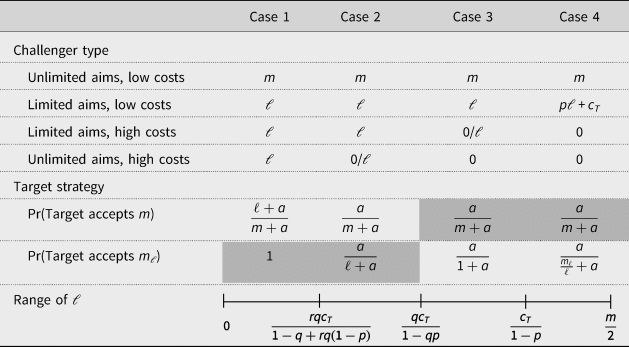
The game with uncertainty over costs and aims has equilibria that take several different forms depending on the parameters and multiple perfect Bayesian equilibria. As above, we focus on equilibria that survive conventional belief restrictions. A full derivation is provided in the Appendix. Table 1 summarizes the key features of the equilibria under four different conditions. The cases are ordered so that moving from left to right means moving from lower to higher values of ℓ, as indicated by the continuum in the bottom row. For each case, the entries show the equilibrium demand of each of the four types of challenger. A slash (/) indicates that the type mixes between the two demands shown.
Equilibrium strategies

Note: This table shows the equilibrium strategies under different configurations of the parameters, with the range of ℓ associated with each case indicated in the bottom row. The shaded values indicate the larger of the acceptance probabilities in each case.
Since there is a lot going on in this table, we walk through the salient points to take away. First, in all cases, two non-zero demands can be seen on the equilibrium path, rather than just one as in the previous game. As before, the resolved challenger with unlimited aims makes the maximal demand that the target will ever accept, m. The resolved challenger with limited aims demands m ℓ, meaning it demands its ideal border, ℓ, or the maximum that the target is willing to concede to such a type, pℓ + c T, whichever is lower. The two unresolved types either demand nothing, or they mimic the demand of the resolved challenger with limited aims in the hopes of getting some concession.
Now we consider how the target responds. For each case, the table indicates the probability that the target will accept either m or m ℓ, with the gray areas indicating the larger of these two probabilities within each case. The limited demand is always accepted with non-zero probability, and there exist two cases (1 and 2) in which the limited demand, m ℓ, is accepted with higher probability than the maximal demand, m. While it may seem intuitive that smaller demands are easier to accept, recall that, in the original version of the game, a demand that is lower than that made by the resolved type with unlimited aims is always rejected. This is because the demand is not simply a proposed division of the good; it is also a signal of the challenger's type, and, in a game with only unlimited aims, a small demand reveals that the challenger has high costs and is therefore unwilling to fight.Footnote 10 In this version of the game, however, a limited demand may be coming from a type with limited aims that is resolved to fight. Thus, the existence of types with limited aims makes limited demands credible.
We also note that the probabilities of acceptance get smaller moving from left to right, or as ℓ increases (a consequence of the fact that 1 ≥ m >ℓ). Why is this? The existence of a resolved type with limited aims not only makes a limited demand credible, it also creates an incentive for unresolved types to mimic that demand in hopes of getting something. The target's response seeks to deter this opportunistic behavior without unnecessarily provoking war with the resolved type. When ℓ is sufficiently low (case 1), the target is willing to make the small concession in order to avoid any risk of war (i.e. the probability of accepting a demand of ℓ is one). Furthermore, since the unresolved type with unlimited aims gets a partial concession in this equilibrium, the target can accept the maximal demand, m, at a higher rate without tempting that type to make the larger demand. As ℓ increases, however, the target has to accept both demands at a lower rate in order to deter unresolved types from making claims. One result of this logic is that, holding the type probabilities, r and q, constant, the probability of war decreases as ℓ decreases: the smaller the ambitions of the limited aims type, the lower the risk of war. Moreover, when ℓ is small (cases 1 and 2), the probability of war strictly decreases with the frequency of limited aims types, r. Thus, the introduction of states that have easily satiable preferences reduces the risk of war due to uncertainty.
A model with two periods
One aspect of the foregoing analysis is that the resolved challenger with unlimited aims always makes the maximum demand that the target would accept. As a result, there is no danger that an insatiable challenger would make a limited demand in order to get a concession, with the long-run goal of coming back for more. The story of the Sudetenland suggests that targets should be concerned about this possibility, particularly if there are endogenous power shifts caused by concession of territory. If the relative power of the challenger increases as the border moves – e.g. because the newly incorporated territory has military-strategic value – then types with unlimited aims would have an incentive to mimic the type with limited aims and then extract more in a subsequent period. If so, the prevalence of small demands could reflect strategic misrepresentation, rather than sincere preferences.
To capture this possibility, we briefly consider a game with a second period. In particular, assume that, if a demand is made and accepted in the first period, the challenger has a second opportunity to make a demand. The target can then accept or reject this new demand, and the challenger, as before, must decide whether to fight or back down in the event of rejection. We further assume that, if the deal in the first period moves the border to some new location x > 0, then the challenger's relative power in the second period is p 2 = p(x), where the function p is non-decreasing in x.
Rather than solve this new model for all configurations of the parameters, we instead ask: under what conditions could insatiable types make limited demands that the target would accept? If in fact limited territorial demands sometimes reflect misrepresentation by types with unlimited aims, what conditions would have to hold for this strategy to work?
In the Appendix, we develop the following results. First, in any equilibrium in which the resolved type with limited aims demands a revision to ℓ in the first period, the resolved type with unlimited aims always prefers to mimic that demand. Thus, the model captures the possibility that limited demands conceal unlimited ambitions. However, precisely for this reason, targets should be wary of accepting this demand, as doing so puts them at risk of facing a stronger challenger and greater demand in the second period. For the limited demand to be accepted with non-zero probability, three conditions must hold: (1) the proportion of challengers with limited aims, r, is relatively high, (2) the extent of the limited aim, ℓ, is relatively low, and (3) the power shift resulting from moving the border to ℓ, p(ℓ) − p(0), is relatively small.Footnote 11 If these conditions are not met, then it is too dangerous for the target to accept a limited demand, since doing so entails a risk that the challenger will turn out to be an insatiable type who comes back and asks for more.
Informally, this means that the Hitler strategy only works if Hitlers are rare. If types with unlimited aims and low costs of war are thought to be common, then limited demands would lose their effectiveness, as targets would have incentives to reject them for fear of increasing the power of an insatiable adversary. This dynamic is similar to what is seen in models of the spiral logic, where a sufficient frequency of greedy or untrustworthy types can foreclose cooperation, even with types that would be easy to satisfy (e.g. Kydd, Reference Kydd2005). The introduction of types with limited territorial ambitions has similar effects as the introduction of status quo or security seeking states in those models: opening up greater possibilities for a mutually beneficial deal.
Implications
Although simple, the model suggests several empirical patterns that should hold if there is heterogeneity in challenger aims and particularly if there is a good chance that those aims are small (i.e. ℓ is small and r is large). The first implication is that small demands for territory can be more effective at obtaining a concession of territory than large demands. In a world of states with unlimited aims, small claims lack credibility in two respects. In the one-period game, making a small claim when a larger one was possible signals low resolve, since a more resolved state would have made the larger demand. Thus, the threat to fight lacks credibility. In the two-period game, a small demand will also not be accepted if there is a high probability that the challenger has unlimited aims and will use the concession to extract even more in the future. In this case, any commitment to not make further demands lacks credibility. For both reasons, target states should not accept small demands in a world in which all or most challengers have unlimited aims. In this world, the most effective demands would be large demands that convey a credible threat to fight (though these, too, would be rejected in the two-period game).
On the other hand, small claims are credible, and hence effective at wresting concessions, in a world in which types with limited aims are common. In such a world, a small demand can convey resolve, since there are states that are resolved to fight for a limited concession. Moreover, in the two-period game, a higher proportion of limited aim challengers makes it less dangerous to concede to a small claim, because the commitment to foreswear further demands is more credible. In short, as the proportion of challengers with limited aims goes up and as the ideal border of this type goes down, small demands become more effective than large ones.
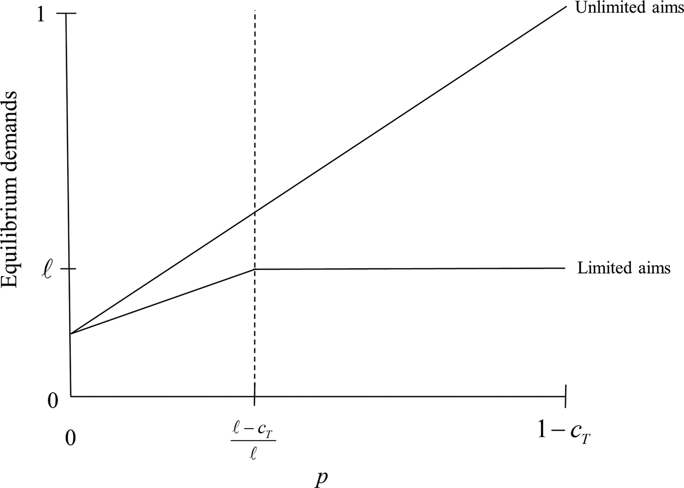
The second implication deals with the effect of the probability of victory, p, on the size of observed demands. Figure 1 shows how the equilibrium demands of challengers with limited and unlimited aims vary with p. Whereas the demand of the challenger with unlimited aims is monotonically increasing in its relative power, the optimal demand of types with limited aims is less sensitive to shifts in power. Although this demand increases with p at low levels, once pℓ + c T > ℓ, these types demand their ideal border and thus have no reason to increase their demand if their power were to increase. Thus, the existence of types with limited aims should make observed demands less sensitive to relative power. Moreover, given a population of challengers with a variety of aims, the heterogeneity of observed demands should increase with the relative power of the challenger.
Equilibrium demands as a function of relative power.

This logic also implies that the existence of limited aims can make agreements robust to exogenous shocks to power. The literature on bargaining and war emphasizes how such shocks can create a commitment problem since the growing state cannot credibly promise not to use its increased power to renegotiate the deal (Powell, Reference Powell2006). If the challenger has limited aims, however, then it can credibly commit to a deal at its ideal border, rendering a positive shock to its power harmless.
Empirical explorations
In this section, we demonstrate several empirical patterns that are consistent with a world populated by states with heterogeneous, often quite limited, ambitions and hard to reconcile with a world of states with insatiable appetites. We show that (1) the size of territorial claims is weakly related to the relative military power between the challenger and target and insensitive to even large exogenous shocks to power, and (2) smaller territorial claims are associated with a higher probability of concessions than larger claims.
The data
The data consists of digital maps of territories that were the subject of interstate territorial disputes from 1947 to 2000. A fuller description of the data can be found in Schultz (Reference Schultz2017).Footnote 12 They are based on the identification of interstate territorial disputes in Huth and Allee (Reference Huth and Allee2002) and updated by Huth, Croco, and Appel (Reference Huth, Croco and Appel2011). These cases involve disagreements over the location of the international boundary between the states, either wholly or in part, disagreements over the ownership of off-shore islands, or cases in which a state does not recognize the sovereignty of another and claims the territory for itself. For each dispute, researchers identified the claims of the disputants and rendered each disputed area – i.e. the region bounded by the claims – as a polygon using geographic information systems software. The data also identify the challenger in each dispute, defined as the state that is seeking to alter the status quo in its favor. In a number of disputes, both states are coded as challengers, either because both claim a region through which there is no status quo border or both states claim territory beyond the status quo.
Although the full data set includes disputes over regions that are part of a colony or dependency of one or both states, the analysis here focuses on disputes over territory that both states claimed to be part of their respective homelands. For the most part, the data set only includes disputes over land areas. Disputes over maritime boundaries are only captured to the extent that they create disputes over off-shore islands. Thus, the overlapping maritime claims in the South China Sea appear as disputes over various islands and atolls in the Spratly Island chain. For this reason, tests reported below generally exclude disputes that were purely of this nature.
An important limitation of these data is that they identify regions that were the subject of conflicting claims to territory; they do not map specific proposals or offers that were made in the course of negotiations. Since the theoretical model speaks of aims and demands, not claims, how should we think about what these data capture? Since claims are chosen strategically, we do not believe they indicate the challenger's ideal border, at least not in all cases. Rather, claims define the region that is the subject of negotiations. They represent a standing demand that the target can in principle always accept.Footnote 13 And while the states might make or entertain offers less than the full claim, the claim plausibly serves as an upper bound on the demands that the challenger can make in bargaining.Footnote 14 Hence, claims give us an indication of the range of demands a challenging state might make. Of course, if most claims were quite expansive, this would be a loose and uninformative constraint. As we will see, however, most disputed regions are in fact quite small, representing a tiny fraction of the total land area of the target. Thus, we contend, variation in the size of disputed regions reflects variation in the scope of demands that states make in bargaining.
In the following tests, we focus on variation in the size of claimed regions as measured by their area, normalized by the area of the target state. We need to emphasize that we are not arguing that area is a good indicator of the stakes of the dispute, as some small regions can have much greater value than much larger regions. But area does tell us how much of the targeted state's territory was not in dispute. For every limited claim we observe, the challenging state could in principle have made a larger claim that encompasses the smaller area. If states' utilities were monotonically increasing in the amount of territory they acquire, then a larger area would have more value than a smaller area contained within it. Put another way, variation in area matters within dyad – that is, comparing each claim to a hypothetical, larger claim in the same dyad – if not across dyads. That is the spirit in which we will analyze the data, even though our tests cannot strictly identify within effects.
Descriptive statistics
The data set identifies 112 dyads that experienced a dispute over homeland territory in the period 1947–2000; because of the existence of reciprocal disputes, there 145 challenger–target directed dyads. Since some directed dyads have more than one dispute at a time, there are 168 distinct disputes.Footnote 15
To get a sense for the variation in claim sizes, we calculate for each directed dyad the total area claimed by the challenger as a percentage of the land area of the target state.Footnote 16 The distribution of these values is shown in Figure 2. While there is a great deal of variation in the amount of territory claimed, the vast majority of disputes implicate a very small fraction of the target state's territory. Focusing only on disputes over land territory (i.e. excluding the 23 directed dyads with disputes over off-shore islands only), one-third cover less than 0.01% of the target's territory, and 57% involve less than 1%. At the other end of the continuum, only eight countries were, at some point, wholly claimed as homeland territory by another: Belize, Cyprus, Mauritania, Kuwait, East Germany, South Korea, Togo, and South Vietnam.
Distribution of disputed area by directed dyad.

These descriptive statistics alone do not permit any particular inference. Nonetheless, the prevalence of many small, even tiny, territorial claims would be odd if the system were populated by states with unlimited aims. If, as in the basic model, challenging states would always try to push their opponent toward their reservation value (i.e. p + c T), such tiny claims would implausibly suggest that challenger states have little ability to seize territory and/or that the costs of conflict to the target are quite small. Without precise measures of the relevant parameters, we cannot rule out that the claims we see represent the equilibrium demands of states with unlimited ambitions. Our skepticism on this point inspired the epigram to this paper.
Claim size and relative power
Turning to more rigorous analysis, we probe the first implication of the model with limited aims: that the extent of territorial claims is only weakly related to the relative power of the disputants. Recall from Figure 1 that while the equilibrium demand in the model with unlimited types is a direct function of p, the close link between demand size and power is weakened when states can have limited aims. Moreover, the logic implies that the heterogeneity of claims sizes should increase with p, as the equilibrium demands of the two types diverge.
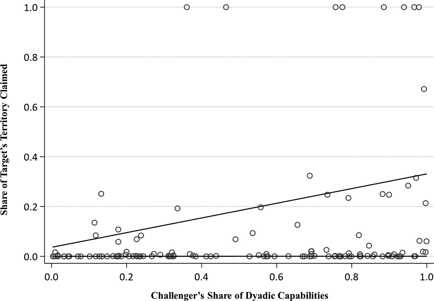
To assess this expectation, Figure 3 displays the relationship between claim size and relative military power at the outset of each dispute. Since the data start in 1947, we drop disputes that originated before that date, leaving 138 dispute onsets. Relative power is based on the national material capabilities scores from Correlates of War (Singer, Bremer, and Stuckey, Reference Singer, Bremer, Stuckey and Bruce1972) and calculated as the ratio of the challenger's capability score to total capabilities in the dyad. As the scatterplot shows, while average claim size does increase with the relative power of the challenger, the variance of the claim sizes increases even more dramatically. This pattern is exactly what Figure 1 would lead us to expect if the world consists of a mixture of states with heterogeneous preferences.
Claim size and initial power balance.

To probe this possibility further, we apply a finite mixture model, which is appropriate for data that may contain multiple subpopulations with different data generating processes. Specifically, we assume that there are two latent types of challengers which differ in the relationship between the challenger's power and the size of its claim. Although the two types can be thought of as corresponding to limited and unlimited aims, the empirical model is agnostic about the distinction and lets the data determine both the relative frequency of the two groups and the effect of power in each. While the details of this analysis are presented in the Appendix, the main result is depicted by the dark lines in Figure 3, which plot the predicted relationships for the two types. The estimates imply that there exists one subpopulation for which claim size is increasing in the challenger's relative capabilities and a second for which the claim is small and essentially constant. The results also imply that the second type is somewhat more frequent in the sample. We do not mean to take the type distinction literally, as the two-class assumption was made for convenience, not realism. Nevertheless, the results suggest not only that there is heterogeneity in the relationship between power and territorial claims but also that the overall relationship is weak.Footnote 17 Moreover, recall that there is good reason to think that claims proxy the upper bound of demands made in actual bargaining. This means that the relationship between capabilities and demands is, if anything, overstated by this analysis.
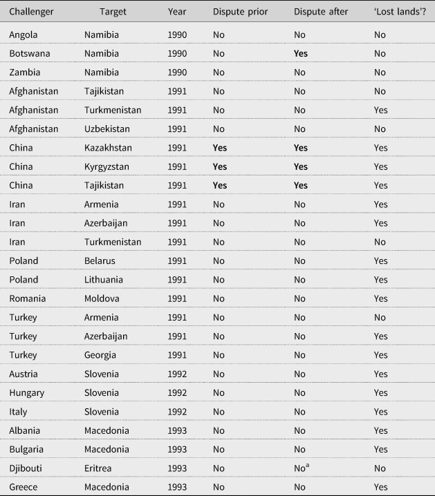
We can also consider the effect of changes to states' relative power on both the size and initiation of a claim. Since states might increase their power in anticipation of making or enlarging a claim, the best way to identify any such effect is to exploit plausibly exogenous shocks to relative power caused by state dissolution. For example, when the Soviet Union broke up, its successor states were weaker relative to their neighbors than the Soviet Union had been. The balance of power on, say, the Poland–Lithuania border changed dramatically before and after 1991. Table 2 lists the 25 largest changes in relative military capabilities (over 5 years) among all contiguous states, including shocks created when a parent state broke into successor states. All of them are associated with the breakups of the Soviet Union and Yugoslavia, the secession of Eritrea from Ethiopia, or the independence of Namibia from South Africa. Thus, these cases create a useful population for seeing how large and exogenous increases in relative power affect territorial claim making. Do challengers that experience large power shocks respond by increasing their claims, thereby putting more of the target's territory on the table?
The 25 largest power shocks and their effect on territorial claims

a Though not captured in the Huth and Allee (Reference Huth and Allee2002) data, Eritrea initiated a claim against Djibouti in 1995.
To answer this question, the table indicates for each directed dyad, whether there was a territorial dispute prior to the shock and whether there was one after the shock. The last column captures the potential for a territorial dispute by indicating whether the challenger might have plausibly claimed ‘lost lands’ in the target state. This coding is based on the outcome of historical disputes in which the challenger ceded territory. Despite the high potential for conflict in these dyads, there was only one case in which the power shock led to a new claim by the challenger. After Namibia's independence, Botswana grew in power from 15 to 50% of dyadic capabilities. Nonetheless, it only laid claim to a small island in the Chobe river, which forms their border in the north east. The island is approximately 5 km2, and thus represents 0.0005% of Namibia's territory.
As with any non-event, the absence of new conflicts in the other dyads is likely over-determined. The coincidence of these shocks with the end of the Cold War could introduce any number of factors that might have explained the lack of new claims, including the role of the international community. Nevertheless, in their examination of Hungary and Romania, Saideman and Ayres (Reference Saideman and Ayres2008) show that restraint was due in large part to the high costs of incorporating lost lands due to the presence of other groups in those areas and diminished identification with the ethnic kin in the irredenta. While external pressures, including the prospect of joining the NATO and the European Union were not irrelevant, they argue that these pressures operated in conjunction with low domestic appetite for territorial expansion.
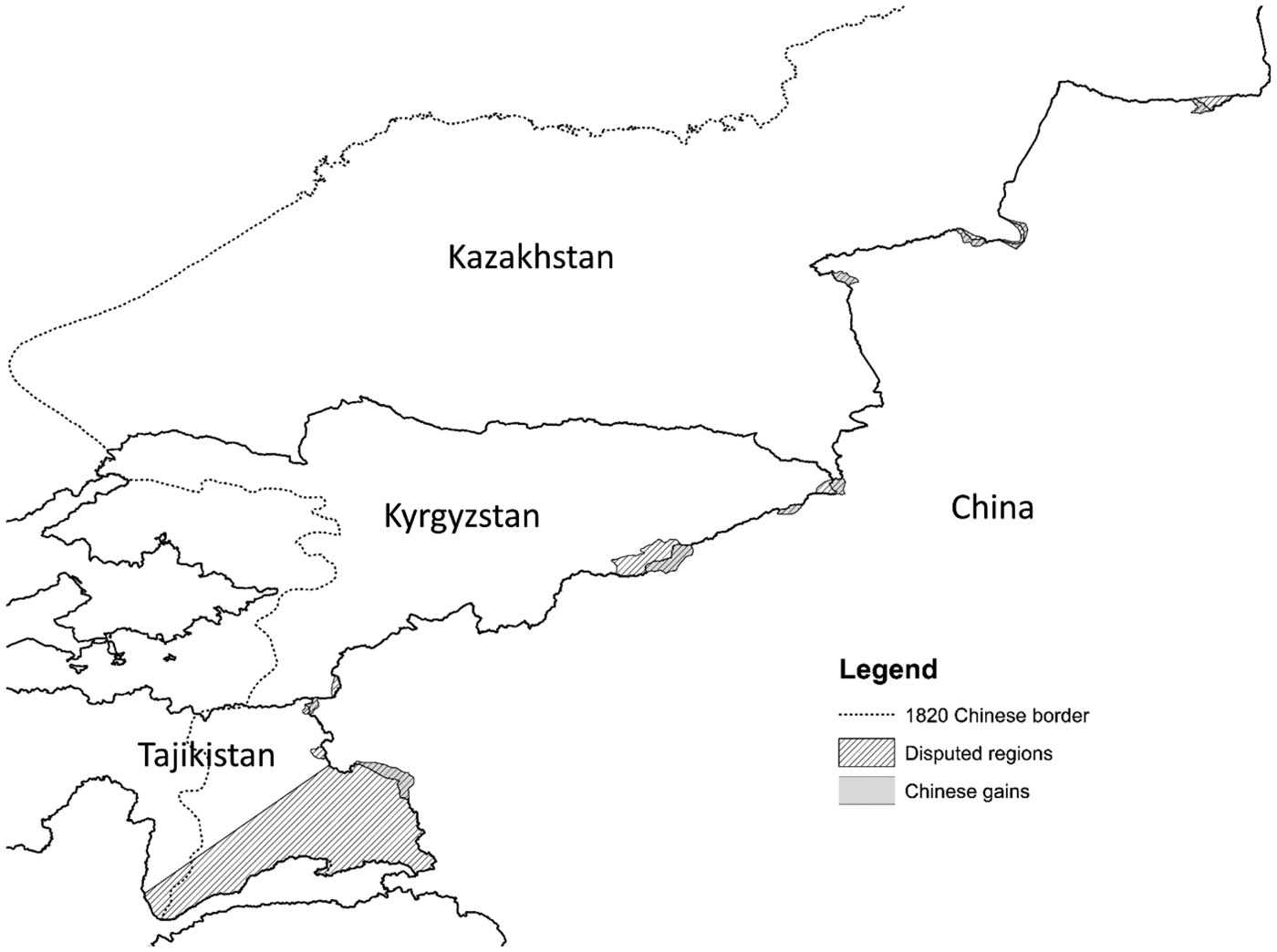
The most interesting cases in this table revolve around China's disputes with the Soviet successor states in Central Asia. China had multiple territorial conflicts with the Soviet Union, and upon the latter's dissolution, the disputed territories were inherited by Kazakhstan, Kyrgyzstan, and Tajikistan. The associated power shock was enormous. Whereas China and the Soviet Union were roughly comparable in terms of their material capability scores (which do not count nuclear weapons), China was 200–300 times more powerful than Tajikistan and Kyrgyzstan and 20–30 times more powerful than Kazakhstan by this measure. Even if the capabilities of the three were combined, the power disparity was enormous.
At the time of the Soviet Union's dissolution, there were reasonable concerns that China would use its newfound power to alter the map (Hyer, Reference Hyer2015, 219). At one level, the disputes were about conflicting interpretations of 19th century treaties that established the boundary in this region.Footnote 18 Figure 4 shows the main areas that were contested, all of which were relatively small with the exception of the dispute in the Pamir Mountains in Tajikistan.Footnote 19 But at a deeper level, China's grievance stemmed from significant territorial losses as a result of ‘unequal treaties’ imposed on it by Imperial Russia. The dotted line on the map indicates the Chinese boundary in 1820, at the height of its territorial reach.Footnote 20 During the Soviet period, China periodically suggested that it might renounce the unequal treaties and thereby revive its latent claim to lost lands (Polat, Reference Polat2002, 31–35; Hyer, Reference Hyer2015, 32–34). Thus, when the breakup of the Soviet Union dramatically increased China's relative power over its new neighbors, China could have expanded the size of its preexisting claims in order to translate that power into larger demands.
China's territorial disputes in central Asia.

In fact, not only did China not increase its territorial claims, but it settled the disputes on relatively favorable terms to its weaker neighbors. Several factors contributed to this outcome. Hyer (Reference Hyer2015, ch. 11) emphasizes the strategic benefits of fostering good relations with these new states, particularly as a hedge against Russian and Western influence in the region. Fravel (Reference Fravel2008, 156–60) emphasizes the importance of the boundary settlements in helping address problems of domestic instability in China's northwest region. To some extent, these logics reflect a consideration that is not in our model nor considered in the bargaining model of war: the costs for making claims, independent of whether those claims give rise to militarized conflict. Chinese leaders clearly saw the outstanding disputes as a hindrance to closer ties with its neighbors and used compromise as a way to obtain their cooperation on other matters.
But this consideration cannot be separated from another factor, emphasized by Fravel (Reference Fravel2008, 150–56): that there would have been costs in terms of domestic governance to bringing these territories inside the boundaries of the state. China's policy was heavily influenced by unrest in Xinjiang province driven by ethnic and religious minorities and by the threat of pan-Islamic and pan-Turkic movements. The potential costs of incorporating more territory inhabited by such populations thus outweighed the benefits of territorial expansion and increased the value of cooperation along border. This consideration was particularly salient in the case of the largest disputed region, in the Pamir Mountains. After its independence, Tajikistan fell into a civil war pitting those allied with the old Soviet regime against a variety of opposition groups, some based in the Pamirs (Kevlihan, Reference Kevlihan2016). The Gorno-Badakshan region, which includes the disputed area, initially declared independence and emerged from the conflict as an autonomous region. The civil war also witnessed a revival of Muslim militancy in Tajikistan. For China, worried about unrest and growing militancy among its own Muslim population in Xinjiang, these considerations made territorial expansion much less appealing (Polat, Reference Polat2002, 44). In the end, China agreed to a settlement that gave it only 1000 km2 of the 28,000 km2 it had claimed.
In sum, the outcomes in these cases, as well as the overall weak relationship between relative power and the extent of territorial ambitions, suggest that appetites for territory are genuinely limited.
Claim size and concessions
The second key implication of our model is that, in a world of states with limited aims, limited claims can be credible and therefore effective at inducing concessions from the target. To assess the relationship between claim size and effectiveness, we coded the outcome of each dispute. Of 168 distinct disputes, 104 were resolved before 2000, of which 62 were resolved as a result of the target's concessions, 32 from the challenger dropping its claim, and the rest due to seizure of the disputed territory by the challenger.
We render the data into dispute-year observations and code whether or not the dispute was resolved in that year due to target concessions. Estimating a logit model with flexible controls for the duration of the dispute is then equivalent to estimating a competing risks hazard model. In any given year, the dispute can continue or end, and we model the probability of one type of ending – resolution through concession – relative to all others. The primary independent variable is the percent of the target's territory that was implicated in the dispute. Because of the highly skewed distribution of dispute sizes, we log this variable.
Though in principle any number of factors might affect the likelihood of concessions, we include several control variables that are particularly likely to confound our inferences. The most important is the strength of the challenger's legal claim. Huth, Croco, and Appel (Reference Huth, Croco and Appel2011) show that challengers with stronger legal claims are more likely to prevail in a territorial dispute. Particularly in the post-1945 period covered by our data, expansive claims for territory are more likely to be legally suspect than small disputes over the alignment of a boundary (Zacher, Reference Zacher2001). Indeed, using data from Huth, Croco, and Appel (Reference Huth, Croco and Appel2011) to classify the legal strength of the challenger's claim, we find that the average size of a weak claim (0.15) is about twice that of a medium (0.082) or strong claim (0.085). Thus, we need to ensure that any association between small claims and target concessions does not arise due to legal considerations. The model includes indicators for medium and strong claims, with weak claims the omitted category. In addition, we include controls for the challenging state's share of military capabilities and whether the territory is valuable for ethnic, strategic, or economic reasons, based on the codings from Huth and Allee (Reference Huth and Allee2002).Footnote 21
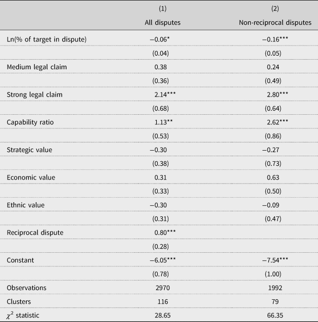
Two additional considerations shape the design of the test. First, because island disputes tend to understate the extent of the territory involved, these cases are dropped from the sample. Second, 56 disputes, or about one-third of the cases, are coded as reciprocal because both states were challengers. In addition to creating non-independent outcomes, reciprocal disputes are more than twice as likely to end with concessions, because they permit each side to trade concessions. Thus, we report estimates for two samples: all cases with a control for reciprocal disputes and the subset of non-reciprocal disputes.
Table 3 reports the estimates both with (column 1) and without (column 2) reciprocal disputes. Standard errors are clustered by challenger–target directed dyad. In both cases, the estimated effect of dispute size is negative. When all disputes are included, the effect is smaller and significant at only the 10% level. Once reciprocal disputes are dropped, the coefficient triples in size and is significant below the 1% level. Strong legal claims and the challenger's share of military capabilities are both associated with a higher likelihood of concessions, as expected, and both of these effects also increase in magnitude when the reciprocal disputes are dropped. None of the indicators for the value of the territory have statistically significant effects in these models.
Dispute size and the likelihood of concessions

Note: Robust standard errors in parentheses clustered by directed dyad. Controls for the duration of the dispute, included as a cubic polynomial, not reported.
***p < 0.01, **p < 0.05, *p < 0.1
Figure 5 shows the predicted probability that a dispute will end with concessions in a given year as a function of the size of the challenger's claim, based on the estimates from column 2. Across the range, the (annual) likelihood that a dispute will end in concessions drops from about 0.04 to 0.003. Much of the drop takes place in the range where claim size is below 1% of the target's territory. Recall from Figure 2, however, that the majority of cases are in precisely that range.
Predicted probability of concession by dispute size.

It is important to note that concessions do not require that the entire disputed area be ceded. Thus, we have not simply found that states are more willing to give up small areas than big ones. Instead, the results show that smaller claims are associated with an increased likelihood that the challenger gets anything. Ideally, we would like to demonstrate that a smaller claim leads to a higher probability of concessions than a larger claim of which the smaller one was a subset, holding all else constant. The observational nature of the data and the fact that there is very little within-dyad variation on claim size makes such a finding impossible. At a minimum the results suggest, however, that states do not undermine the credibility of their threats by making a small demand when larger ones were available.
Conclusions
In his study of war, Holsti (Reference Holsti1991, 14) notes the distinction between asking ‘why do nations fight?’ and ‘what are they willing to fight over?’Footnote 22 In their own way, both realism and the bargaining model of war privilege the first question. Realism does so by assuming homogeneity in state preferences and seeing every contest as a struggle for power. The bargaining model of war does so by assuming that issues of contention are ubiquitous and focusing instead on the features of the strategic interaction that cause bargaining to fail. In arguing that variation in preferences matter, we are not trying to supplant this latter approach. Rather, we are arguing that preference heterogeneity is an essential feature of the strategic interaction, with real consequences for conflict and peace.
Once we take preference heterogeneity seriously, several striking implications emerge (Moravscik, Reference Moravcsik1997; Gartzke, Reference Gartzke2000). In particular, the existence of states with limited appetites for territory can explain three features of territorial conflict that have not previously been documented: the fact that territorial disputes tend to take place over areas that are relatively small and clearly bounded, the low sensitivity of territorial claims to relative power and shocks to relative power, and the effectiveness of small claims in extracting concessions. As we have shown, these patterns are hard to reconcile with a world in which states have unlimited territorial ambitions. These insights further suggest that problems of credible commitment due to exogenous or endogenous power shocks – two mechanisms for war highlighted by the bargaining model (Fearon, Reference Fearon1995; Garfinkel and Skaperdas, Reference Garfinkel and Skaperdas2000; Powell, Reference Powell2006) – need not be severe in this context, since states with genuinely limited aims can credibly commit to restraint.
At the same time, we acknowledge that some of the patterns we observe could be explained by alternative mechanisms. The most plausible alternative hinges on the role of international law, particularly in the post-1945 period that is covered by the data. Many scholars have pointed to rise in this period of a norm of territorial integrity and a prohibition against conquest (e.g. Zacher, Reference Zacher2001; Fazal, Reference Fazal2007; Goertz, Diehl, and Balas, Reference Goertz, Diehl and Balas2016). Legal norms that constrain the kinds of demands that states can make and their effectiveness could induce some effects similar to those caused by limited aims. In particular, this legal environment might favor relatively small claims over undefined or poorly defined boundaries, while delegitimizing claims that cover large swaths of a target's territory.
While we cannot rule out the contribution of legal/normative considerations, we make two points in response. First, although claim size is correlated with the strength of the challenger's legal claim as coded by Huth, Croco, and Appel (Reference Huth, Croco and Appel2011), there is still considerable variable in claim size within each category of legal strength. This suggests that the legal framework is only loosely related to claim size, and the weak correlation means that we were able to identify separate, and complementary, effects of these variables on the likelihood of concessions.
Second, and more fundamentally, the rise of territorial integrity norm itself is likely connected to the underlying preferences. Prohibitions against conquest and obligations to respect territorial integrity were articulated and codified into law after World War I (Korman, Reference Korman1996; Hensel et al., Reference Hensel, Allison and Khanani2009), but they had little effective bite until after World War II. The reasons for this development are not fully understood, and scholars have advanced a variety of candidate mechanisms. Some of these explanations hinge on international developments, such as the role of the United Nations and international organizations (Zacher, Reference Zacher2001; Goertz, Diehl, and Balas, Reference Goertz, Diehl and Balas2016), the bipolar competition between the superpowers (Waltz, Reference Waltz1979), or the role of the United States in promoting or policing the norm (Fazal, Reference Fazal2007, 47–52). Other explanations, however, rest on factors that have changed the relative costs and benefits of acquiring new territory, such as the spread of democracy (Morrow et al., Reference Morrow, de Mesquita, Siverson and Smith2006; Fearon, Reference Fearon2018) or the declining value of territory for economic welfare due to the rising importance of trade and foreign direct investment (Rosecrance, Reference Rosecranz1986; Brooks, Reference Brooks2007). In Africa, where there was a strong norm of respecting inherited borders in spite of their imposed and artificial nature, Goemans and Schultz (Reference Goemans and Schultz2017) note that many states saw territorial expansion as unattractive because it would increase ethnic heterogeneity and exacerbate challenges of governance. Thus, the post-1945 international legal environment may itself be a product of the limited preferences for territory we emphasize, rather than an alternative explanation for our results. The co-evolution of and interaction between legal norms and preferences for territory deserves additional research.
Indeed, our findings point to the need for further work on how states or governments form preferences over territory and how they articulate claims, both domestically and internationally. While rooting the analysis in the bargaining model of war allows us to speak to broader theoretical issues, the results suggest that a model of territorial conflict might be fruitfully built from the ‘ground up,’ with attention to the costs and benefits associated with incorporating territory, the interaction of domestic and international interests, and the strategic, political, and legal issues that influence claim making. On the empirical side, geospatial data make it possible to ask detailed questions about why and when states and leaders want some pieces of territory but not others (Goemans and Schultz, Reference Goemans and Schultz2017). Which territory is valuable and for what reasons? Is territory mostly a container of political and natural resources? Or are territorial claims specified and targeted for largely domestic political purposes? Research that examines in depth what territory is put on the bargaining table, and why, offers significant new answers and hopefully new perspectives on old questions of war and peace.
Supplementary material
The supplementary material for this article, including replication data and code, can be found at https://doi.org/10.1017/S1752971919000071
Author ORCIDs
Kenneth A. Schultz, 0000-0002-8009-075X
Acknowledgments
We would like to express our thanks for the very helpful comments we received from many people over the years while this project gestated. These include, but are not limited to, David Carter, Mark Fey, Erik Gartzke, Brenton Kenkel, David Lake, David Lindsay, Renanah Miles, Kristopher Ramsay, Anne Sartori, Xiaoyan Qiu, and the anonymous referees.