

Introduction
Casimir de Candolle's (Reference de Candolle and Huber1906) description of Begonia albomaculata was based on a single collection, Huber 1518, made in the Pampa del Sacramento Range near the border of the Loreto and San Martín regions of Peru. Smith & Schubert (Reference Smith, Schubert and Macbride1941) excluded the species from their account of the Begoniaceae in the Flora of Peru as a “nomen subnudum” because they considered its original description “insufficient for identification”. Later, Smith & Wasshausen (Reference Smith and Wasshausen1984, Reference Smith, Wasshausen, Harling and Andersson1986) published emended descriptions of Begonia albomaculata based solely on herbarium material collected in Ecuador. This material is distinct from the type of Begonia albomaculata C.DC. and represents an undescribed taxon closely related to Begonia tiliifolia C.DC., which is described in a companion paper in this volume (Tebbitt et al., Reference Tebbitt, Hughes, Pérez and Moonlight2017).
Our examination of the two syntypes of Begonia albomaculata (Huber 1518 [2]) indicates that the species has no characters to distinguish it from Begonia mayasiana L.B.Sm. & B.G.Schub. Similarly, four sheets in G-BOISS that were cultivated from seed presumed to have been collected from the type gathering of Begonia albomaculata (Barbey s.n. [2] and Beauverd 2695 [2]) also show no features that distinguish them from B. mayasiana. Begonia mayasiana is, therefore, newly synonymised with B. albomaculata. An emended description and lectotypification of Begonia albomaculata is provided, and the known range of the species is emended to include the Amazonas, Huánuco, Loreto, San Martín and Ucayali regions of Peru; Acre state of Brazil; and the Ecuadorian province of Pastaza.
This taxonomic work on Begonia albomaculata C.DC. prompted a re-evaluation of Andean species and specimens related to this species. Begonia albomaculata belongs to a group of species within Begonia sect. Knesebeckia (Klotzsch) A.DC. that also includes B. longimaculata Irmsch. and B. maynensis A.DC. These three species are distributed in Amazonian Ecuador, Peru and Brazil, and in the case of Begonia maynensis and B. longimaculata, additionally in the foothills of the neighbouring Andes. These species are distinguished from all other species classified in Begonia sect. Knesebeckia by their combination of simple, entire leaves that in mature plants are clustered at the top of a short (< 60 cm), unbranched stem, the lower leaves having abscised, and their conspicuous persistent stipules. Begonia maynensis and B. longimaculata are readily distinguished from B. albomaculata by their cuneate leaf bases.
Fieldwork in Ecuador and Peru has demonstrated that individuals corresponding to the types of either Begonia maynensis or B. longimaculata frequently co-occur within single populations, with the former plants differing from the latter only by having concolorous green leaf blades rather than leaf blades that are green with elongated white markings along the central portions of their intervenal laminae. Examination of the type of Begonia longimaculata (Lobb s.n. [W]), similarly indicates that the only distinction between B. longimaculata and B. maynensis is this leaf coloration. Accordingly, Begonia longimaculata is newly recognised here as a synonym of B. maynensis, which is lectotypified here.
Our herbarium-based investigations also identified a new species from the Pasco region of Peru with a single collection from neighbouring Huánuco region. This species is most similar to Begonia albomaculata C.DC. but differs in a number of key characters. The plants are shorter, reaching only 40 cm, with smaller inflorescences dichotomous only to five times, and smaller leaves to only 25 cm long. Their male flowers have narrower, shorter petals to 10 × 5 mm, and they have c.20 stamens whereas those of Begonia albomaculata have c.40 and petals reaching 22 × 18 mm. Their fruits are unequally 3-winged, with the larger wing ascending over the styles, whereas those of Begonia albomaculata are usually equal to subequal or occasionally unequal (e.g. Croat & Sizemore 81610). This species is described here as Begonia chemillenensis Moonlight sp. nov.
We further identified a single specimen from the Madre de Dios region of Peru that represents a new species most similar to Begonia chemillenensis. This specimen differs from Begonia chemillenensis in its smaller leaves (10–12.5 cm) and in key inflorescence characteristics, including its serrate bracts and lanceolate to ovate, serrate bracteoles, and is unique among Andean species of Begonia sect. Knesebeckia in having orange flowers. We describe this specimen here as Begonia scorpiocaulis Moonlight & Tebbitt sp. nov.
We informally name Begonia maynensis, B. albomaculata, B. chemillenensis and B. scorpiocaulis the B. maynensis group of Begonia sect. Knesebeckia. Molecular phylogenetic data (Moonlight et al., Reference Moonlight, Richardson, Tebbitt, Thomas, Hollands, Peng and Hughes2015) indicate that Begonia sect. Knesebeckia is polyphyletic, and that the B. maynensis group (represented by B. maynensis) is only distantly related to B. incarnata Link & Otto, the type species of the section. Ongoing phylogenetic work is being conducted to improve the sectional classification of the Begonia maynensis group and, in particular, to clarify its relationship to the B. acerifolia group as defined by Tebbitt (Reference Tebbitt2016). Accordingly, Begonia chemillenensis and B. scorpioides are not here assigned to a section. A key is provided to the Begonia maynensis group.
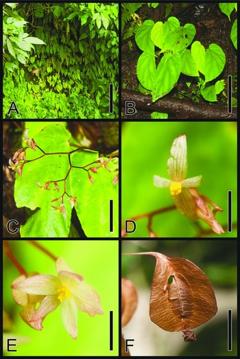
Begonia albomaculata C.DC. A, Habitat; B, habit; C, branch of inflorescence; D, male flower, front view; E, female flower, front–side view; F, fruit, side view. Scale bars: A, 50 cm; B, 15 cm; C, 5 cm; D and E, 2 cm; F, 15 mm. Photographs taken from P.W. Moonlight & A. Daza 126 (F), 175 (B, C and D) and 198 (A and E).

Key to the Begonia maynensis Group
-
1a. Leaf bases cuneate on both sides of the leaf blade ____________ 3. B. maynensis
-
1b. Leaf bases cordate, rounded, or broadly rounded on the larger side of the leaf blade, cuneate to rounded on the narrow side of the blade _________________ 2
-
2a. Leaf lamina 10–12.5 cm long; inflorescence bracts serrate; bracteoles ovate with serrate margins ______________________________________ 4. B. scorpiocaulis
-
2b. Leaf lamina (12–)15–30 cm long; inflorescence bracts entire, bracteoles lanceolate with entire margins ________________________________________ 3
-
3a. Petiole 8–22 cm; leaf lamina 8–17 cm wide; male flowers with c.40 stamens; upper edge of largest fruit wing ascending _____________________ 1. B. albomaculata
-
3b. Petiole 3.5–10 cm; leaf lamina 4–10 cm wide; male flowers with c.20 stamens; upper edge of largest fruit wing perpendicular to the ovary 2. B. chemillenensis
Taxonomic Treatment
1. Begonia albomaculata C.DC., Bot. Mus. Paraense Hist. Nat. 4: 593 (1906). – Type: PERU. Collinas in the Pampa del Sacramento between the río Ucayali and río Huallaga, 26 xi 1898, Huber 1518 (lecto G, designated here; isolecto MG [MG1518]). Figs 1 , 6 A.
Begonia mayasiana L.B.Sm. & B.G.Schub., Publ. Mus. Hist. Nat. “Javier Prado”, Ser. B. Bot. 17: 7, pl. 3, 1964. – Type: Peru. Amazonas. Provincia de Bagua. Rainforest along Quebrada Mirana (above Km. 227 of Marañón road), valley of río Marañón above Cascadas de Mayasi), alt. 450–500 m., 8 ix 1962, J. J. Wurdack 1902 (holo US!; iso AA!, K!, F!, NY!, S!, UC!, USM!) syn. nov.
Caulescent herb; glabrous throughout, 20–60 cm tall; stem erect, flexuous, succulent, unbranched to rarely branching near the base; internodes to 6 cm long at base of stem and progressively shorter towards apex; stipules persistent, lanceolate, 1.2–3.5 × 0.4–0.8 cm, the apex acuminate to mucronate, the margins entire. Leaves alternate, clustered towards apex of stem, basifixed; petioles 8–22 × 0.2–0.4 cm; lamina strongly asymmetrical, elliptic to ovate, 15–30 × 8–17 cm, base cuneate to rounded (to cordate) on narrow side, broadly rounded on wide side, apex acuminate, margins irregularly dentate with a 1-mm tooth at end of each major vein, and a short hair at tip of each tooth, upper surface dark green, sometimes with small white flecks, lower surface green; veins palmate-pinnate, 6- to 9-veined from base, 6–9 lateral veins on the wider side of lamina, 4–6 lateral veins on narrower side. Inflorescences: axillary, arising from axil of most leaves and often persistent after each leaf has abcissed, a dichotomous cyme branching 4–8 times, protandrous; peduncle 2–8.5 cm long, secondary branches to 2.5 cm long, subsequent branches decreasing in length, final branches to 1.4 cm; bracts tardily deciduous, lanceolate, 3–9 × 1–4 mm, apex acute to mucronate, margin entire. Male flowers: pedicels 15–20 mm long; tepals 4, white, margins entire, outer 2 broadly ovate to orbicular, 7–22 × 4–18 mm, apex obtuse to rounded, inner 2 narrowly oblanceolate 8–12 × 2–4 mm, apex acute; stamens c.40, attached along the length of a 1–2 mm long column, filaments 1–4 mm long, longer at base of column, anthers broadly obovoid, c.0.5 mm long, dehiscing by lateral slits. Female flowers: pedicels 15–22 mm long; bracteoles deciduous, like the bracts, tepals 5, deciduous in fruit, white, subequal, lanceolate to ovate, 4–9 × 3–6 mm, apex obtuse to acute, margins entire; ovary body ellipsoid, 15–8 × 4–8 mm, unequally 3-winged, largest wing 13–18 × 7–15 mm, triangular, base rounded, apex perpendicular to the ovary, smaller 2 wings 13–18 × 5–8 mm, triangular, base rounded, apex perpendicular to ovary; placentae axile, bilamellate, ovuliferous all over; styles 3, tardily deciduous in fruit, 4–6 mm long, bifid c.2 mm from base, the branches erect, twice spirally twisted. Fruiting pedicel elongating to 4 cm. Fruit ellipsoid, body enlarging to 20 × 10 mm, unequally 3-winged, wings same shape as in the ovary, the larger wing enlarging to 30 × 16 mm and ascending to 8 mm above the ovary, the smaller 2 wings enlarging to 28 × 10 mm. Seeds globose, c.0.2 × 0.2 mm.
Phenology
Begonia albomaculata has been collected in flower and fruit year-round.
Distribution
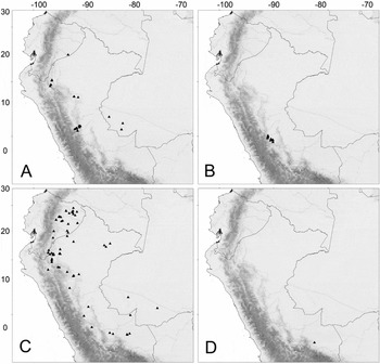
Begonia albomaculata has been collected in the Peruvian regions of Amazonas, Loreto, San Martín, Huánuco and Ucayali; the Brazilian state of Acre; and the Ecuadorian province of Pastaza.
Habitat
Terrestrial, usually on rocky slopes by streams in tropical forest, 220–900 m altitude.
IUCN conservation category
Begonia albomaculata is a widespread and locally common species throughout the region from which it has been recorded. Accordingly, we assess it as of Least Concern (LC), according to IUCN criteria (2015).
Additional specimens examined. ECUADOR. Pastaza: Captaine Chiriboga, río Pastaza. 2°32′S, 76°49′W, 21 vii 1988, W.H. Lewis, M. Elvin-Lewis, C.E. Cerón, E.J. Kennelly & M.C. Gnerre 13742 (MO).
PERU. Amazonas: Prov. Bagua, Dist. Imaza, Region del Marañón, Comunidad de Yamayakat, Quebrada Kusu – Chapi, río Marañón, 04°55′S, 78°18′W, ii 1995, R. Vasquez, N. Jaramillo, R. Apanu, & R. Kugkumas 19770 (MO, USM); Prov. Bagua, Dist. Imaza, Newvo Samaria (anexo de UVT), 19 iii 1995, C. Diaz, A. Peña, J. Mena, & D. Kakias 7587 (MO); Prov. Bagua, Dist. Imaza, Comunidad Aguaruna de Kampaentza (PUJAIM), Terrenos de propiedad de Jan Mayán, 6 x 1994, C. Diaz, J. Mayán, A. Peña, & E. Mayán 7301 (MO); Prov. Bagua, Dist. Imaza, río Cenepa Region, region nor oriental del Marion, communidad Samaria, 4°51′S, 78°8′W, i 1995, V. Hodges & J. Gorham 235 (MO); Prov. Bagua, Dist. Imaza, río Cenepa Region, region nor oriental del Marion, communidad Yamayakat, 4°55′S, 78°19′W, i 1995, V. Hodges & J. Gorham 59 (MO); Prov. Bagua, Yamayakat, 4°55′S, 78°19′W, 3 ii 1996, N. Jaramillo, M. Jaramillo, & D. Chamit 1065 (MO, NY); Prov. Bagua, Dist. Imaza: Región del Marañón, comunidad de Yamayakat, Quebrada Kusu – Chapi, río Marañón. Area permanente 500 × 500 m Parcele “E”, 4°55′S, 78°19′W, ii 1995, R. Vasques, N. Jaramillo, R. Apanu, & R. Kugkumas 20098 (MO); Prov. Bagua, Dist. Imaza – Yamayakat, 4°55′S, 78°19′W, 25 v 1996, R. Vasques & A. Vasques 20983 (MO); Prov. Bagua, Dist. Aramango, road from Bagua towards Santa Maria del Nieve, c.30 minutes by car N. of El Muyo, 5°17′S, 78°25′W, 30 i 2016, P.W. Moonlight & A. Daza 126 (E, MOL); Prov. Bagua, c.1 km NE of Quebrada Chinganza (0 km NE of Mayo) on bank of río Marañón, 05°25′S, 78°28′W, 11 vi 1986, S. Knapp & P. Alcorn 7724 (MO, USM). – Loreto: Prov. Coronel Portillo, Boquerón, 8 xi 1964, R. Ferreyra 16068 (MO, USM). – San Martín: Prov. Lamas, Dist. Caynarachi, route from Tarapoto to Yurimaguas, 6°22′S, 76°15′W, 4 ii 2016, P.W Moonlight & A. Daza 175 (E, MOL); Achinamiza, lowland rainforest along río Huallaga, 15 v 1979, D.C. Wasshausen & F. Encarnación 1070 (K, MO, NY, US, USM). – Huánuco: Huánuco-carretera Pucallpa, viii 1943, C.A. Ridoutt 13847 (USM); Along steep cliffs W of río Huallaga above bridge over río Huallaga on road to airport, 09°14′S, 78°0′W, 5 iv 1984, T.P. Croat 57965 (MO, USM); Prov. Leoncio Prado; Dist. Rupa Rupa, Al oeste de Tingo María cerro frente al Aeropuerto, 3 viii 1978, J. Schunke 10439 (MO); Prov. Leoncio Prado, Dist. Rupa Rupa, Camino a Jacintillo, (Al oeste de Tingo Maria), 2 xi 1971, J. Schunke 5107 (G, NY, US); Valley of río Huallaga, along steep banks of río Monzón, near bridge over río Patay Rondos on road from Tingo María to Monzó, 09°17′S, 76°05′W, 2 vi 1998, T.B. Croat & M. Sizemore 81610 (F, MO, US, USM); Along road from Tingo Maria to Monson, vicinity of río Patay Rondos, cuevas de Gucharo “Parque National Tingo Maria”, 9°21′S, 76°12′W, 4 iv 1984, T.B. Croat 57921A (MO); Tingo Maria, across the Huallaga on trail to Monson, 30 x 1949 – 19 ii 1950, H.A. Allard 21854 (US); Cayumba entre Huánuco y Tingo Maria, 15 vii 1948, R. Ferreyra 4224 (MO, MOL, USM); Prov. Huánuco, Dist. Chinchao, route from Tingo María to Carpish, 9°30′S, 75°56′W, 10 ii 2016, P.W. Moonlight & A. Daza 213 (E, MOL). – Ucayali: Prov. Padre Abad., Dist. Padre Abad, Cuenca del río Aguaytia. Quebrada el Velo de la Novia, margen derecha del río Yurmac, 09°03′S, 75°48′W, 30 vi 2004, J. Schunke Vigo & J.G. Grahams 15771 (G, MOL); Prov. Padre Abad, Dist. Padre Abad, c.2 km N of Boqueron de Padre Abad, 9°4′S, 72°42′W, 8 ii 2016, P.W. Moonlight & A. Daza 204 (E, MOL); Prov. Padre Abad., Dist. Padre Abad, Boqueron de Padre Abad, 9°4′S, 75°40′W, 8 ii 2016, P.W. Moonlight & A. Daza 198 (E, MOL); Prov. Padre Abad., Dist. Padre Abad, Cumbre de la Divisoria, entre Ucayali y Huánuco, cabecera del río Yurac, afluente del río Aguaytia, 9°11′S, 75°47′W, 3 vii 2007, J.G. Graham & J. Schunke Vigo 4156 (MOL).
BRAZIL. Acre: Cruzeiro do Sul, Basin of rio Juruá, rio Juruá-Mirim and Igarapé Periquito (right bank tributary) across from Santo Antônio, “Salão”, c.8°13′S, 73°02′W, 11 v 2003, D.C. Daly, E.C. Oliveira & L. Johnson 11700 (MO, NY); Cruzeiro do Sul, rio Juruá & rio Moa. Vicinity of Porangaba, rio Juruá-Mirim, 21 v 1971, P.J.M. Mass, K. Kubitzki, W.C. Steward, J.F. Ramos, W.S. Pinheiro & J.F. Lima P13238 (K, NY, RB); Jordão. rio Tarauacá, downstream of Jordão, “Colacação do Sebastião”, 8°48′S, 71°47′W, 10 ii 2009, R. Goldenberg, F.A. Michelangeli, P. Acevedo-Rodriguez, F. Obermuller, E.C. Oliveira & H.M. Oliveira 1382 (RB); Aldeia São Joaquim, Centro de Memória, Parque Fundo do Segrado. Terra Indígena Huni Kuin do Baixo rio Jordão, 9°22′S, 71°54′W, A. Quinet 2912 (RB).
CULTIVATED. Serres de la Pressière, Chambéry (presumed cultivated from type collection), 4 ii 1910, Barley s.n. (G-BOISS [2]); Serres de Jardin Botanique de Genève (presumed cultivated from type collection), 10 iv 1908, Beauverd 2695 (G-BOISS [2]); Serre chaude de la Pressière (presumed cultivated from type collection), 8 vi 1909, Beauverd s.n. (G-BOISS).
When in flower or fruit, Begonia albomaculata is easy to distinguish from B. chemillenensis. Male flowers have around twice the number of stamens of Begonia chemillenensis, and the fruits and male flowers of B. albomaculata are significantly larger (the largest tepals of B. albomaculata reach 22 mm, whereas those of B. chemillenensis reach 12 mm). Identification of sterile specimens may be more difficult, especially towards the south of the range of Begonia albomaculata, where specimens are occasionally relatively small and may overlap in size with larger plants of B. chemillenensis. Sterile living specimens are best distinguished by their thicker, more succulent leaves. In herbarium specimens, the thinner leaves of Begonia chemillenensis tend to dry light green and translucent, whereas those of B. albomaculata dry dark green and opaque.
The specimen Wasshausen & Encarnación 1070 (US) is annotated as the holotype of Begonia pluvialis L.B.Sm. & Wassh., but this name has never been published. This epithet is now unavailable because of the later publication of Begonia pluvialis L.B.Sm. ex S.F.Sm. & Wassh. (Smith & Wasshausen, Reference Smith and Wasshausen1999). Similarly, the collection Allard 21854 (US) is annotated as the holotype of Begonia berniceana L.B.Sm. & Wassh., but again this name has never been published. The label of this latter specimen also states that the collection was made in the San Martín region of Peru, but the locality appears to be in the Huánuco region. We see no reason to separate either specimen from Begonia albomaculata.
Further images of Begonia albomaculata are available on the Begonia Resource Centre (Hughes et al., Reference Hughes, Moonlight, Jara-Muñoz, Tebbitt and Pullen2015–).
2. Begonia chemillenensis Moonlight, sp. nov. – Type: Peru. Pasco: Prov. Oxapampa. Dist. Palcazú. CC NN. Loma Linda. 10°22′S, 75°04′W, 16 vi 2010. R. Vasquez, M. Huaman, & R. Rivera 36606 (holo HOXA; iso E, MO [MO-2080522], USM). Figs 2 , 3 , 6 B.
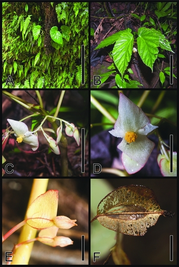
Begonia chemillenensis Moonlight. A, Habitat; B, habit; C, branch of inflorescence; D, male flower, front view; E, female flower, front view; F, fruit, side view. Scale bars: A, 50 cm; B, 10 cm; C, 25 mm; D and F, 10 mm; E, 5 mm. Photographs taken from P.W. Moonlight & A. Daza 278 (F) and 314 (A–E).

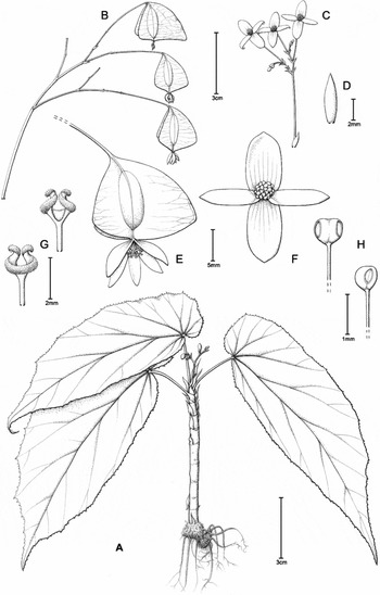
Begonia chemillenensis Moonlight. A, Habit; B, branch of infructescence; C, branch of inflorescence; D, bract; E, female flower, side view; F, male flower, front view; G, style, back and front views; H, stamen, front and side views. Scale bars: A–C, 3 cm; D and G, 2 mm; E and F, 5 mm; H, 1 mm. Drawn from I. Huamantupa et al. 11435 (A), P.W. Moonlight & A. Daza 287 (B, F and H) and 317 (C–E, and G).

Begonia chemillenensis Moonlight is most similar to B. albomaculata C.DC. but is best distinguished by its generally shorter petioles (those of B. albomaculata are 8–22 cm long); narrower leaf blades (those of B. albomaculata are 7–17 cm wide); smaller, lanceolate to narrowly ovate outer male tepals with acute to obtuse apices (those of B. albomaculata are broadly ovate to orbicular, 8–22 × 4–18 mm, with obtuse to broadly rounded apices); c.20 stamens (B. albomaculata has c.40); and the perpendicular angle of the upper edge of the largest ovary and fruit wing relative to the ovary (that of B. albomaculata is ascending).
Caulescent herb; glabrous, 20–40 cm tall; stem erect, flexuous, succulent, unbranched to rarely branching near base; internodes to 2.5 cm long at base of stem and progressively shorter towards apex; stipules persistent, lanceolate, 1–2 × 0.2–0.4 cm, apex acuminate to mucronate, the margins entire. Leaves alternate, clustered towards apex of stem, basifixed; petioles 3–10 × c.0.2 cm; lamina strongly asymmetrical, elliptic to oblanceolate, 12–25 × 4–10 cm, base cuneate to rounded (to cordate) on narrow side of lamina, broadly rounded on large side, apex acuminate, margins irregularly dentate with a short hair at tip of and between each tooth, with a 2- to 3-mm tooth at end of each major vein, upper surface green, lower surface pale green; venation palmate-pinnate, 6- to 8-veined from base, 8–10 lateral veins on the wider side, 6–8 lateral veins on the narrower side. Inflorescences: axillary, arising from axil of most mature leaves and often persistent after leaf has abscissed, a dichotomous cyme branching to 5 times, protandrous; peduncle 4–8(–12) cm long, secondary branches to 2 cm long, more distal branches decreasing in length, quinary branches to 1 cm; bracts tardily deciduous, lanceolate, 5–8 × 1–3 mm, apex acute to mucronate, margins entire. Male flowers: pedicels 1–2 cm long; tepals 4, white, margins entire, outer 2 lanceolate to narrowly ovate, 7–12 × 2–6 mm, apex acute to obtuse, inner 2 narrowly lanceolate 5–11 × 2–3 mm, apex acute; stamens c.20, attached along a 1-mm column, filaments to 3 mm long; anthers broadly obovoid, c.0.5 mm long, dehiscing by lateral slits. Female flowers: pedicels 1–1.5 cm long; bracteoles deciduous, like the bracts, tepals 5, deciduous in fruit, white, subequal, lanceolate to ovate, 7–8 × 4–5 mm, apex acute to obtuse, margins entire; ovary body ellipsoid, 10–15 × 4–6 mm, unequally 3-winged, largest wing 15–17 × 5–12 mm, triangular, base rounded, apex perpendicular to the ovary to ascending 2 mm above ovary, smaller 2 wings 12–15 × 1–5 mm, triangular, base rounded apex perpendicular to the ovary; placentae axile, bilamellate, ovuliferous all over; styles 3, subpersistent in fruit, c.3 mm long, bifid c.1.5 mm from base, branches erect, twice spirally twisted. Fruiting pedicel elongating to 2.5 cm. Fruit ellipsoid, body enlarging to 20 × 8 mm, unequally 3-winged, larger wing enlarging to 25 × 15 mm and extending to 2 mm above ovary, base rounded, apex truncate to acute, smaller 2 wings as in ovary. Seeds globose, c.0.2 × 0.2 mm.
Phenology
Begonia chemillenensis has been collected flowering and fruiting from February to August.
Distribution
Begonia chemillenensis is known primarily from the Pasco region of Peru, with a single collection from the neighbouring Huánuco region.
Habitat
This species grows in primary forest at 320–1480 m altitude, typically on calcareous soils within and surrounding limestone outcrops. Associated species include ferns, Gesneriaceae spp., Selaginella spp. and several bryophytes.
In one location (10°3′S, 75°32′W), a population of Begonia arrogans Irmsch. was observed growing on patches of acidic soils intermingled with alkaline soils supporting B. chemillenensis. A group of c.10 individuals was observed displaying intermediate characteristics between the two species (P.W. Moonlight & A. Daza 276). These putative hybrids appeared sterile. Photographs of this collection are available on the Begonia Resource Centre (Hughes et al., Reference Hughes, Moonlight, Jara-Muñoz, Tebbitt and Pullen2015–).
IUCN conservation category
Begonia chemillenensis has an area of occupancy of > 1000 km2, a large proportion of which falls within the well-protected Parque Nacional Yanachaga-Chemillén. Fieldwork during February 2016 identified a large number of seemingly stable populations of the species, both within and around Parque Nacional Yanachaga-Chemillén. Accordingly, we classify Begonia chemillenensis as Least Concern (LC), according to IUCN criteria (2015).
Etymology
Begonia chemillenensis is named for the Chemillén cordillera at the centre of the range of the species. The name ‘Chemillén’ is in the local indigenous Yanachaga language.
Additional specimens examined. PERU. Huánuco: Prov. Puerto Inca, Dist. Codo de Pozuzo, Route from Pozuzo to Codo de Pozuzo, c.3.5 km from Puente Paujil, 9°56′S, 75°31′W, 20 ii 2016, P.W. Moonlight & A. Daza 283 (E, MOL); Pasco: Prov. Oxapampa, Dist. Pozuzo, Route from Pozuzo to Codo de Pozuzo, 10°1′S, 75°30′W, 20 ii 2016, P.W. Moonlight & A. Daza 287 (E, MOL); Prov. Oxapampa, Pozuzo, 10°04′S, 75°31′W, 19 viii 2010, Xue-Jun Ge et al. 441 (USM); Prov. Oxapampa, Dist. Huancabamba, Camino a Pozuzo, 10°04′S, 75°32′W, 2 vi 2004, R. Rojas, M. Huaman, A. Peña, & J. Mateo 2496 (HOXA, MO, USM); Prov. Oxapampa, Dist. Pozuzo, camino to mirador from Pozuzo, 10°4′S, 75°32′W, 20 ii 2016, P.W. Moonlight & A. Daza 274 (E, MOL); ibid, P.W. Moonlight & A. Daza 278 (E, MOL); Prov. Oxapampa, Dist. Pozuzo, road from Pozuzo to Oxapampa, 10°9′S, 75°33′W, 21 ii 2016, P.W. Moonlight & A. Daza 292 (E, MOL); Parque Nacional Yanachaga-Chemillén, Path from Huampal Control Centre “camino de colones”, 10°10′S, 75°34′W, 21 ii 2016, P.W. Moonlight & A. Daza 294 (E, MOL); Parque Nacional Yanachaga-Chemillén, El Huampal. 10°11′S, 75°34′W, 1 vii 2003, H. van der Werff, R. Vásquez, B. Gray, R. Ortiz, & N. Davila 17924 (HOXA, MO); Dist. Pozuzo, Parque Nacional Yanachaga-Chemillén. Sector Huampal. Trocha entre el PC Huampal y pastizales del Sr Shuller. 10°11′15″S, 75°34′9″W, 19 iv 2012, K. V. Durand, T. R. Zender, & F. G. Shareva 202 (HOXA, MO); Prov. Oxapampa, Dist. Palcazú, Sector San Francisco de Pichanaz (Puente Albariño), 10°15′S, 75°15′W, 12 ii 2005, R. Rojas, R. Vásques, M. Huaman, R. Francis & B. Vasques 3490 (HOXA, MO); Prov. Oxapampa, Dist. Palcazú, Parque Nacional Yanachaga-Chemillén, Sector Paujil, trail from Pampa Pescado to “las cavernas”, 10°20′S, 75°15′W, 25 ii 2016, P.W. Moonlight & A. Daza 317 (E, MOL); Prov. Oxapampa, Dist. Palcazú, Route to Izcosacin, km 30, 10°20′S, 75°6′W, 24 ii 2016, P.W. Moonlight & A. Daza 314 (E, MOL); Prov. Oxapampa, Dist. Palcazú, Parque Nacional Yanachaga-Chemillén, Estación Biológica Paujil, boca del río pescado, 10°20′S, 75°4′W, 10 iii 2012, R. Vásquez, L. Valenzuela & M. Ureta 37853 (HOXA); Prov. Oxapampa, Dist. Palcazú, Parque Nacional Yanachaga-Chemillén. Sector Paukil. Parcela RAINFOR 2, 10°21′S, 75°15′W, 23 iv 2008, I. Huamantupa, A. Peña, J. Mateo, A. Sebastian, & L. Rios 11435 (HOXA, MO [2], USM [2]); Dist. Palcazú, Parque Nacional Yanachaga-Chemillén. Quebrada David. 10°23′S, 75°17′W, 28 v 2011, R. Vásquez, M. Villalba, & C. Mateo 37411 (HOXA, MO); Oxapampa. Along road Chatarra-Cacazu, 10°32′S, 75°04′W, 11 vii 2003, H. van der Werff, R. Vásquez, B. Gray, R. Ortiz, & N. Davila 18298 (HOXA, MO); Prov. Oxapampa, Dist. Villa Rica, Route from Villa Rica to Puerto Berudez, km. 88, 10°33′S, 75°5′W, 24 ii 2016, P.W. Moonlight & A. Daza 313 (E, MOL).
Further images of Begonia chemillenensis are available on the Begonia Resource Centre (Hughes et al., Reference Hughes, Moonlight, Jara-Muñoz, Tebbitt and Pullen2015–).
3. Begonia maynensis A.DC., Ann. Sci. Nat., Bot., IV, 11: 126–127, 1859; L.B.Smith & B.G. Schubert (1941) Flora of Peru 13(4): 194; L.B. Smith & D.C. Wasshausen (1986) Flora of Ecuador 25(133): 49–50. – Type: PERU. near Tarapoto, vi 1855. Spruce 4859 (lecto (designated here): G-DC [G00675969], (Photo F, K, MO); isolecto BM, E [E00157075], G [G00237559], G-BOIS, G-DC [G00676066], K [2: K000006031; K000006032], MG [MG019634], NY [NY00118630], OXF, TCD [TCD0005563]). Figs 4 , 6 C.
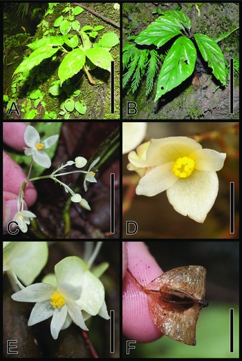
Begonia maynensis A.DC. A, Habit, non-variegated individual; B, habit, variegated individual); C, branch of inflorescence; D, male flower, front view; E, female flower, front–side view; F, fruit, side view. Scale bars: A and B, 15 cm; C, 2 cm; D, 5 mm; E, 8 mm; F, 10 mm. Photographs taken from P.W. Moonlight & A. Daza 20 (B), 65 (E and F) and 185 (A, C and D).

Begonia longimaculata Irmsch., Bot. Jahrb. Syst., 76: 89–90, 1953. – Type: PERU. Without further locality, W. Lobb s.n. (holo: W [W 1889-0159133]) syn. nov.
Caulescent herb; glabrous throughout, 20–40 cm tall; stem erect, flexuous, succulent, unbranched to rarely branching near base; internodes to 3 cm long at base of stem and progressively shorter towards apex; stipules tardily deciduous, lanceolate, 1–1.5(–2.2) × 0.4–0.6 cm, apex acuminate to mucronate, margins entire. Leaves alternate, clustered towards apex of stem, basifixed; petioles 0.5–3 × c.0.2 cm; lamina asymmetrical, elliptic to oblanceolate, (8–)10–22 × 2.5–10 cm, base cuneate at both sides of lamina, apex acuminate, margins irregularly dentate, eciliate to sparsely ciliate, occasionally with a 1-mm tooth at end of each major vein, upper surface green or green with silver blotches between veins, lower surface pale green to purple; venation palmate-pinnate, 3-veined from base, 6–8 lateral veins on wider side of lamina, 6–8 lateral veins on narrower side. Inflorescences: axillary, arising from axil of most mature leaves and often persistent after leaf has abscissed, a dichotomous cyme branching to 5 times, protandrous; peduncle 1–3.5(–4.5) cm long, secondary branches to 1.5 cm long, more distal branches decreasing in length, quinary branches to 0.5 cm; bracts tardily deciduous, lanceolate, 3–5 × 1–2 mm, apex acute to mucronate, margins entire. Male flowers: pedicels 0.6–1.5 cm long; tepals 4, white, margins entire, outer 2 lanceolate to ovate, 4–8 × 4–7 mm, apex acute, inner 2 narrowly lanceolate 4–6 × 2 mm; stamens 20–25, attached along the length of a 2 mm long column, filaments to 2 mm long; anthers broadly obovoid, c.0.5 mm long, dehiscing by lateral slits. Female flowers: pedicels 0.5–1 cm long; bracteoles deciduous, like the bracts, tepals 5, persistent in fruit, white, subequal, lanceolate to ovate, 5–11 × 3–5 mm, apex obtuse to acute, margins entire; ovary body ellipsoid, 7–15 × 2–4 mm, unequally 3-winged, base cuneate, apex truncate, largest wing 12–20 × 5–10 mm, triangular, base cuneate to rounded, apex perpendicular to the ovary, smaller 2 wings 10–12 × 2–5 mm, triangular, base rounded, apex perpendicular to ovary; placentae axile, bilamellate, ovuliferous all over; styles 3, subpersistent in fruit, c.4 mm long, bifid c.2 mm from base, the branches erect, twice spirally twisted. Fruiting pedicel elongating to 2.5 cm. Fruit ellipsoid, enlarging to 20 × 8 mm, unequally 3-winged, larger wing enlarging to 25 × 15 mm and extending to 4 mm above ovary, base rounded, apex obtuse to acute, smaller 2 wings as in ovary. Seeds globose, c.0.2 × 0.2 mm.
Phenology
This species has been collected in flower and fruit year-round.
Distribution
Begonia maynensis has been collected in the Ecuadorian provinces of Pastaza, Tungurahua, Napo, Orellana, Morona-Santiago, Sucumbios and Zamora-Chinchipe; the Peruvian regions of Amazonas, Huánuco, Ucayali, Pasco, Junín, Cuzco, Loreto, San Martín and Madre de Dios; and the Brazilian state of Acre.
Habitat
Begonia maynensis is recorded from both primary and disturbed forest. It usually grows in moist places, and can be epiphytic, lithophytic or terrestrial. The species usually occurs in tropical forests at 200–500 m altitude but occasionally may grow at higher altitudes in montane forests, up to 1050 m.
IUCN conservation category
Begonia maynensis is often locally abundant throughout the region from which it has been recorded. Accordingly, we assess this species as Least Concern (LC), according to IUCN criteria (2015).
Representative specimens examined. ECUADOR. Sucumbios: río Aguarico, Dueno, 30 km E of Santa Cecilla, 14 iii 1968, G. Harling, G. Storm & B. Strom 7650 (MO, NY). – Sucumbios-Napo: Road Lago Agrio – El Chaco, 23 xi 1973, H. Lugo 3527 (GB, MO). – Napo: Estación Experimental de INIAP, San Carlos 6 km al SE de Los Sachas, 5 iv 1985, M.A. Baker 5895 (MO [2], QCNE); Chonta Punta at río Napo, in the vicinity of Santa Rosa, 5 v 1972, H. Lugo 2152 (K, NY); Reserva Biológica Jatun Sacha, río Napo, 8 km abajo de Misahualli, 1°04′S, 77°36′W, 17 i – 6 ii 1987, C. Cerón 611 (MO, QCA, QCNE); Campana Cocha, Comunidad Quicha, margen izquierdo del río Napo, 1°05′S, 77°30′W, 22 viii 1980, J.A. Jaramillo & F. Coello 3744 (MO, QCA [2]); río Bueno, tributary of the río Suno, 4–5 km N of Santa Rosa, 7 v 1972, H. Lugo 2176 (MO). – Napo-Orellana: Tena-Pano road, 18–19 vii 1982, L. Besse, H. Kennedy & R. Baker 1656 (MO). – Orellana: Shushufindi [Nuevo Leja], road Coca, [Puerto Francisco de Orellana], L.S. Holguer 3295 (QCA); c.10 km NW of Coca, 25 ii 1980, C.C. Berg & R.W.A.P. Akkermans 1082 (AAU, MO, QCA); Anangu, río Napo, trail to terra firma line, 0°31′S, 76°23′W, J.E. Lawesson, T. Læssøe & P.M. Jørgensen 39609 (MO, QCA, QCNE); Laguna de Yuturi, 0°36′S, 76°1′W, N. Jaramillo & Grijalva 11532 (QCA); Reserva Etnica Huaorani, comunidad Guiyero, bloque 16 petrolero de Repsol, km 32, al lado del río Tiputini, 00°36′S, 76°27′W, 17 ii 2005, B. Freire & D. Naranjo 567 (MO); Yasuni National Park, Estación Cientifica Yasuni, at río Tiputini and surroundings, 26 km along the road from Napo (Plot 18), 0°40′S, 76°24′W, 20 iv 1996, A.D. Poulsen, R. Moran, H. Tuomisto & K. Ruokolainen 1235 (QCA, QCNE); Via de acceso Chiruisla–río Tiputini, colecciones en los alrededores de km 12+786, 00°41′S, 75°55′W, Pérez et al. 1274 (QCA); Aguarico, Parroquia Nuevo Rocafuerte, comunidad Martinica (Kichwa), D. Reyes & L. Carrillo 963 (MO, QCNE); Parque Nacional Yasuni, Comunidad Miwaguno a 140 km al sur del Coca, via al Pindo, Bloque 14 (ENCAN), río Shiripuno, 00°43′S, 76°43′W, 11 v 2004, B. Freire & D. Naranjo 729 (MO, QCNE); Aguarico, Reserva Etnica Huaorani, carretera y oleoducto de Maxus en construcción km 67–69, 0°49′S, 76°22′W, 1–3 xii 1993, M. Aulestia, N. Andi & E. Nenquerei 1394 (MO); Parque Nacional Yasuni, POZO PETROLERO DAIMI 2, 00°55′S, 76°11′W, 26 v – 8 vi 1988, C.E. Cerōn & F. Hurtado 4073 (MO, QCNE). – Tungurahua: Quito, 51 km from Puyo on road to Tena, 1°20′S, 77°56′W, 2 ii 1984, W.S. Hoover 498 (MO, QCA). – Pastaza: Pastaza Canton, Pozo Villano, 2 km del pueblo de Villano, 01°25′S, 77°20′W, 3 xii 1991, G. Tipaz, S. Espinoza & C. Gualinga 483 (MO); Pastaza, Villano, Pozo petrolero Villano 2 de ARCO, al sur del río Lliquino, 01°28′S, 77°27′W, 28 viii 1997, A. Alvarez, E. Freire & H. Vargas 2187A (QCNE, MO); Parque Pedagogico Etnobotanico Omaer, río Villano, Blanc et al. BLLM-96-538 (QCA); Loracachi, on the path to Lagartococha, 1°38′S, 75°58′W, J. Jaramillo, F. Coello & A. Freire 30974 (MO, QCA); Pozo petrolero “Corrientes” de UNOCAL, 35 km al sur-oriente de Curaray, 01°43′S, 76°49′W, 1–15 ix 1990, S. Espinoza 274 (MO, QCNE); Pacayacu on the río Bobonaza, c.16 km NW of Barayacu, L.S. Holguer 5257 (MO, QCA); Pastaza Canton, 01°43′S, 76°49′W, 1–31 viii 1990, E. Gudiño 565 (QCNE); río Capihuari, tributary of río Pastaza, 2°30–31′S, 76°50–55′W, 23 vii 1980, B. Øllgaard, E, Asanza S., J.S. Brandbyge, S. Roth & C.R. Sperling 35122 (AAU, QCA); río Pastaza between Destacamento Chiriboga and Apachi Entza, 2°20–32′S, 76°55′–77°8′W, 24 xii 1980, B. Øllgaard, E.C. Asanza, J. Brandbyge, S. Roth & C. Sperling 35228 (MO, QCA). – Morona-Santiago: Región de la Cordillera del Cóndor, Centro Shuar Chimius, 3 v 2006, C. Kajekai & A. Wisum 443 (MO); Canton Santiago de Mendez, between Patuca and Santiago, 2°59′S, 78°13′W, 12 i 2014, A. Jara 2649 (ANDES, QCA). – Zamora-Chinchipe: Nangaritza Canton, río Nangaritza, Shaime, Orilla derecha del río, 04°20′S, 78°40′W, 8 xii 1990, W. Palacios 6664 (MO, QCNE); río Nangaritza, Colina Salade, c.2 km E of Destacamento Shaime, 04°22′S, 78°40′W, Øllgaard 98480 (QCA).
PERU. Loreto: Prov. Alto Amazonas Puranchim, río Sinchiyacu, 2°50′S, 76°55′W, 30 iii – 1 iv 1987, W.H. Lewis, M. Elvin-Lewis, D. Fast & J.R.Campos 13392 (MO); Prov. Maynas, Roca Fuerte (Momon), 03°40′S, 73°30′W, 7 vii 1984, R. Vásquez & N. Jaramillo 5230 (MO, NY, USM); Above Pongo de Manseriche, mouth of río Santiago, 21 xi 1931, Y. Mexia 6130 (BM, G, GH, MO, NY); Prov. Mariscal Ramon Castilla. Margen izquierda del río Yavari, entre Colonia Angamos y Lago Preto. Siteo 3 Quebrada Limera, 9 iv 2003, H. Beltrán, N. Pitman, R. Garcia, C. Vriesendorp & M. Huite 5699 (USM); Prov. Alto Amazonas, Shucushuyacu (río Huallaga), 06°02′S, 75°50′W, 13 ix 1981, R. Vásquez & N. Jaramillo 2452 (MO). – Amazonas: Prov. Condorcanqui, Dist. Santiago, Cerros Kampankis: Serranía entre los ríos Santiago y Morena, desde río Marañón hasta frontera con Ecuador, Campamento 2, Qda. Katerpisa, 04°02′S, 77°33′W, 9 viii 2011, I. Huamantupa, D. Neill, N. Pitman & C. Kajekai 15556 (USM); Prov. Condorcanqui, Dist. El Cenepa, Comunidad de Mamayaque, río Cenepa, Quebrada Saasa, 04°31′S, 78°11′W, 26 i 1997, R. Vásquez, R. Rojas, A. Peña, E. Chávez & E. Quiaco 22336 (HUT, MO, MOL, USM) Prov. Bagua, Dist. Imaza, Comunidad Aguaruna de Putuim, Arriba río Shimutaz, 04°55′S, 078°19′W, 19 vi 1996, E.R. Rodriguez, P. Mtamain, E. Chavez-Agkuash & W. Atamain 1114 (HUT, MO, USM [2]); Prov. Bagua, Dist. Bagua, entre Mesones Muro y Uraguza, 05°03′S, 78°20′W, 21 vii 2004, R. Rojas, R. Vásquez & R. Apanu 3190 (HOXA, MO). – San Martín: Zepelacio, near Moyobamba, vii 1934, G. Klug 3716 (BM, GH, K, MO, NY); Dist.Tarapoto. Carretera Tarapoto-Yurimaguas, c. km 13.5, 17 vii 1980, M. Rimanchi 5243 (USM [2]); Tarapoto, vi 1855, Spruce 3959 (K [2]); Prov. Mariscal Caceros, Dist. Campanilla. Route from Tarapoto to Tocache, 7°35′S, 76°41′W, 6 ii 2016, P.W. Moonlight & A Daza 185 (E, MOL). – Huánuco: Pachitea; Puerto Inca. Forest along small river just N of town, 9°18′S, 74°58′W, 15 ix 1982, R.B. Foster 8830 (F, MO, USM). – Ucayali: Prov. Purús, Dist. Purús, Cuenca del río Purús. río Curanja, cerca la comunidad native de Colombiana, 10°04′S, 71°06′W, 15 ii 2000, J.G. Graham & J. Schunke Vigo 900 (F, G). – Pasco: Prov. Oxapampa, Dist. Palcazú. Comunidad Nativa Alto Lagarto. Reserva Comunal Yanesha, 10°8′S, 75°22′W, R. Rojas & G. Ortiz 8195 (HOXA). – Junín: Prov. Satipo. La Molina University Field Station, c.10 km N of Satpio on 5S, c.1 km E of field station, 11°10′S, 74°38′W, 8 vii 2014, P.W. Moonlight 65 (E, MOL). – Cuzco: Prov. La Convención, Dist. Echarati. Pagoreni well site, 11°41′S, 73°00′W, 18 iv 1998, P. Nuñez, H. Beltrán, W. Nauray, L. Acurio, R. de la Colina, N. Llerena & A. Salsas 21572 (USM); Prov. Cuzco, Dist. Camisea, Campamento San Martin–C., Camimisea Production Unit, S and SW of Camp, 11°47′S, 72°41′W, 24 i 1997, P. Acevedo-Rodriguez, D. Bell, K. Rankin & S.F. Smith 9050 (CUZ, G, K, MO, NY, USM). – Madre de Dios: Prov. Manu, Parque Nacional del Manu, río Manu, Cocha Cashu Station, 11°50′S, 71°25′W, 21 vii 1984, R. Foster 9668 (F, MO, NY, USM).
BRAZIL. Acre: Municipality of Tarauacá. rio Mury, 12 km above confluence with rio Tarauacá, 20 ix 1958, G.T. Prance, J.F. Ramos & L.G. Farias 7409 (GH, K, NY, P); Tarauacá, rio Tarauacá. Seringal Universo, Colocação Camaru, c.8°25′S, 71°18′W, 21 ix 1994, D.C. Daly, M. Silveira, R Saraiva, L.A. Lima & N. Goldstein 8289 (NY); Sena Madureira. Basin of rio Iaco (tributary of rio Purus), Fazenda São Jorge I, property of Acre Brasil Verde, timber concession of Laminados Triunfo Ltda., 107 km NW of rio Branco on BR-364, then c.22 km E on Toco Preto access road, 9°25′S, 68°36′W, 8 vii 2008, D.C. Daly, M. Silveira, E.C.Oliveira & D.A.Martins 13258 (RB).
Further images of Begonia maynensis are available on the Begonia Resource Centre (Hughes et al., Reference Hughes, Moonlight, Jara-Muñoz, Tebbitt and Pullen2015–).
4. Begonia scorpiocaulis Moonlight & Tebbitt, sp. nov. – Type: Peru. Madre de Dios: Pantiacolla, serrania across río Alto Madre de Dios from Shintuya, 29 x 1979. A. Gentry, J. Terborgh, J. Aronson & R. Ramirez 27367 (holo: MO [MO-2154624]). Figs 5 , 6 D.
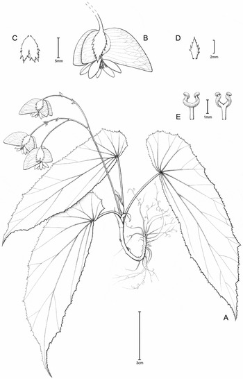
Begonia scorpiocaulis Moonlight & Tebbitt. A, Habit; B, female flower, side view; C, bracteole; D, bract; E, style, back and front views. Scale bars: A, 3 cm; B and C, 5 mm; D, 2 mm; E, 1 mm. Drawn from holotype A.H. Gentry 27367 (MO).

Distribution of species of the Begonia maynensis group of Begonia sect. Knesebeckia (Klotzsch) A.DC. A, Begonia albomaculata C.DC.; B, B. chemillenensis Moonlight; C, B. maynensis A.DC.; D, B. scorpiocaulis Moonlight & Tebbitt.

Begonia scorpiocaulis Moonlight & Tebbitt is most similar to B. chemillenensis, differing in its smaller size (B. scorpiocaulis is up to 20 cm tall, whereas B. chemillenensis reaches maturity at over 20 cm tall) and leaves (leaves in B. chemillenensis are rarely shorter than 15 cm and narrower than 5 cm; those of B. scorpiocaulis are known only to 12.5 × 3.5 cm), by its serrate bracts (B. chemillenensis has entire bracts), serrate, ovate bracteoles (B. chemillenensis has lanceolate, entire bracteoles), its bright orange female flowers (those of B. chemillenensis are white), and its largest fruit wing with a straight top edge ascending to 2 mm above the ovary (B. chemillenensis has straight, horizontal or convex top edge ascending to c.2 mm above the ovary).
Caulescent herb; glabrous throughout, 15–20 cm tall; stem erect, flexuous, succulent, unbranched; internodes to 2 cm long at base of stem and progressively shorter towards apex; stipules persistant, lanceolate, 0.4–1 × 0.2–0.4 cm, apex acuminate to mucronate, margins entire. Leaves alternate, clustered towards apex of stem, basifixed; petioles 3–4 × 0.1–0.2 cm; lamina strongly asymmetrical, elliptic to oblanceolate, 10–12.5 × 2.5–3.5 cm, base cuneate on narrow side of lamina, broadly rounded on large side, apex acuminate, margins irregularly dentate with a short hair at tip of and between each tooth, with a c.2-mm tooth at end of each major vein; venation palmate-pinnate, 6- to 8-veined from base, 6–8 lateral veins on wider side of lamina, 2–5 lateral veins on narrower side. Inflorescences: axillary, arising from axil of most mature leaves and often persistent after leaf has abscissed, a dichotomous cyme branching c.4 times, protandrous; peduncle to 6 cm long, secondary branches to 2 cm long, subsequent branches decreasing in length, final branches to 0.8 cm; bracts tardily deciduous, narrowly lanceolate, c.3 × 1 mm, apex acute, margins serrate. Male flowers: unknown. Female flowers: pedicels c.15 mm long; bracteoles persistent, lanceolate to ovate, c.3 × 5 mm, apex acute to rounded, sometimes incised to 2 mm, margins serrate; tepals 5, orange, subequal, lanceolate to ovate, 4–7 × 2–3 mm, apex obtuse to rounded, margins entire; ovary body ellipsoid, c.6 × 4 mm, unequally 3-winged, largest wing 7–9 × 10–13 mm, triangular, base rounded, apex ascending to c.2 mm above ovary, smaller 2 wings 6–8 × 5–6 mm, triangular, base rounded, apex perpendicular to ovary, rounded; placentae axile, bilamellate, axile, ovuliferous all over; styles 3, subpersistent in fruit, c.5 mm long, bifid c.1 mm from base, branches erect, twice spirally twisted. Fruiting pedicel unknown. Fruit unknown. Seeds unknown.
Begonia scorpiocaulis is a poorly known species and its male flowers, fruits and seeds are unknown. However, it is readily identified by its serrate bracts and bracteoles, its unusual orange flowers, and its smaller leaves than the closely related Begonia chemillenensis.
Phenology
Begonia scorpiocaulis was collected in flower in October.
Distribution
Begonia scorpiocaulis is known only from the type locality near Shintuya, Madre de Dios.
Habitat
Begonia scorpiocaulis is believed to be an epiphyte but it is unclear upon what. The altitude of the collection (480–840 m) suggests the species inhabits humid, premontane forest.
IUCN conservation category
The type locality of Begonia scorpiocaulis is situated within a protected area. There is no information available on the abundance of the species, and therefore the species is classified as Data Deficient (DD) under IUCN criteria (2015).
Etymology
The name scorpiocaulis emphasises the scorpioid form of the stems of the type collection, which spiral markedly towards the base of the stem. This stem form is also frequently found in the closely related species Begonia chemillenensis and B. maynensis.
Acknowledgements
We thank the curators of AAU, B, BKL, BM, BR, BRIT, C, CAS, CGE, COL, CPUN, CUZ, E, E-GL, F, G, GB, G-BOISS, G-DC, GH, GOET, HOXA, HUT, K, LIL, LPB, MEDEL, MO, MOL, MOL-WEB, NY, OXF, P, QCA, QCNE, QPLS, S, SEL, TEX, UC, US, USM, USZ, W and Z for scanning or loaning material or for allowing us to work in their herbaria. We thank the Ecuadorian Ministerio del Ambiente and the Ministerio del Ambiente del Perú for granting us permission to conduct the fieldwork and collect specimens, and the University of Edinburgh Davis Expedition Fund, the James and Eve Bennett Trust, as well as the American Begonia Society for funding the fieldwork. We also thank Claire Banks for providing the artwork. This manuscript forms part of P.M.’s PhD research supported by the M.L. MacIntyre Begonia Trust. The Royal Botanic Garden Edinburgh is supported by the Scottish Government's Rural and Environment Science and Analytical Services Division.