

1. Introduction
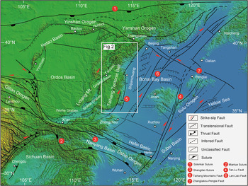
The North China Craton (NCC) lost part of its lithospheric mantle during the Mesozoic (Menzies et al. Reference Menzies, Fan, Zhang, Prichard, Alabaster and Harris1993; Griffin et al. Reference Griffin, Zhang, O’Reilly, Ryan, Flower, Chung, Lo and Lee1998; Zhu et al. Reference Zhu, Chen, Wu and Liu2011, Reference Zhu, Xu, Zhu, Zhang, Xia and Zheng2012). The thinning of the lithosphere resulted in widespread Mesozoic magmatism (Wu et al. Reference Wu, Lin, Wilde, Zhang and Yang2005; Gao et al. Reference Gao, Rudnick, Xu, Yuan, Liu, Walker, Puchtel, Liu, Huang, Wang and Yang2008; Yang et al. Reference Yang, Wu, Wilde, Chen, Liu and Xie2008) and extensional deformation characterized by the formation of metamorphic domes and core complexes (Davis et al. Reference Davis, Qian, Zheng, Yu, Wang, Mao, Gehrels, Muhammad, Fryxell, Yin and Harrison1996, Reference Davis, Zheng, Wang, Darby, Zhang, Gehrels, Hendrix and Davis2001, Reference Davis, Darby, Zheng and Terry2002; Darby et al. Reference Darby, Davis and Zhang2004; Passchier et al. Reference Passchier, Zhang, Konopásek, Bruhn and Burlini2005; Lin & Wang, Reference Lin and Wang2006; T Wang et al. Reference Wang, Zheng, Zhang, Zeng, Donskaya, Guo and Li2011, Reference Wang, Guo, Zheng, Donskaya, Gladkochub, Zeng, Li, Wang and Mazukabzov2012; Lin et al. Reference Lin, Faure, Chen, Ji, Wang, Wu, Charles, Wang and Wang2013a, b; Xia et al. Reference Xia, Liu, Ni, Zhang, Shi and Wu2016), half-graben basins (Ren et al. Reference Ren, Tamaki, Li and Zhang2002; Meng et al. Reference Meng2003), large-scale normal faults (Davis et al. Reference Davis, Darby, Zheng and Terry2002; Lin et al. Reference Lin, Faure, Monié, Scharer and Panis2008; Wang & Li, Reference Wang and Li2008) and syntectonic granitic domes (SR Lin et al. Reference Lin, Faure, Chen, Ji, Wang, Wu, Charles, Wang and Wang2013). Within northern China, the E–W-trending orogenic belts (i.e. the Qinling–Dabie, Inner Mongolia and Yinshan–Yanshan orogenic belts) and NE–NNE-trending structures (i.e. the Tan–Lu Fault system and the Taihang Mountain Belt) constitute the main tectonic framework (Fig. 1; Wang & Li, Reference Wang and Li2008).
Regional structural map of the Taihang–Qinling Mountains (modified after SZ Li et al. Reference Li, Guo, Xu, Somerville, Cao, Yu, Wang, Suo, Liu and Zhao2015).

Located at the central part of the NCC, the Taihang Mountain Belt has a complex evolution history spanning back to the Mesozoic (Wang & Li, Reference Wang and Li2008; Cao et al. Reference Cao, Li, Xu, Guo, Liu, Zhao, Liu and Dai2015; SB Li et al. Reference Li, Wang, Zhang, Zhang, Liang and Qiu2015; SZ Li et al. Reference Li, Guo, Xu, Somerville, Cao, Yu, Wang, Suo, Liu and Zhao2015; Wang et al. Reference Wang, Zhou, Liu, Li and Yang2018). This mountain belt represents an important transition between distinctly different crustal thicknesses, crustal velocity structures, rock densities, Precambrian basement rocks and overlying Proterozoic–Mesozoic sedimentary layers (Zhao et al. Reference Zhao, Sun, Wilde and Li2005; Bao et al. Reference Bao, Song, Xu, Wang, Sun, Mi, Yu and Li2013).
The discovery of three planation surfaces (Xu et al. Reference Xu, Gao, Sun and Song2001) and river incision (C Wu et al. Reference Wu, Ma, Zhang, Wu and Zhao1999) have been described by previous researchers, indicating that the Taihang Mountain Belt was subjected to multiphase uplifting periods during the Mesozoic–Cenozoic period. A detailed uplift history of the Taihang Mountain Belt will provide valuable insight into the geomorphological evolution of North China and the formation mechnism of the Taihang gravity lineament.
Due to the low closure temperature of helium in apatite (Wolf et al. Reference Wolf, Farley and Silver1996) and zircon (Reiners et al. Reference Reiners, Spell, Nicolescu and Zanetti2004), (U–Th)/He thermochronology has been widely used in the study of geomorphological evolution (Flowers & Farley, Reference Flowers and Farley2012) and uplift histories of mountain belts (Ehlers & Farley, Reference Ehlers and Farley2003). Previous low-temperature thermochronology studies (mainly using fission track) have been carried out on the cooling/uplift history of the Taihang Mountain Belt in the last two decades (Zhang et al. Reference Zhang, Xu, Wang and Guo2002; Qing et al. Reference Qing, Ji, Wang, Peng, Niu and Ge2008; Cao et al. Reference Cao, Li, Xu, Guo, Liu, Zhao, Liu and Dai2015; SB Li et al. Reference Li, Wang, Zhang, Zhang, Liang and Qiu2015; Meng et al. Reference Meng, Wang and Chen2015; Zhao et al. Reference Zhao, Liu, Mountney, Lu, Cao, Yang and Xue2015). However, most of these studies focused on the evolution of the central (Qing et al. Reference Qing, Ji, Wang, Peng, Niu and Ge2008; Cao et al. Reference Cao, Li, Xu, Guo, Liu, Zhao, Liu and Dai2015; Chang et al. Reference Chang, Qiu, Zhao, Shen, Liu and Liu2018, Reference Chang, Qiu, Liu, Cai, Xu and Liu2019) and southern parts (Cao et al. Reference Cao, Li, Xu, Guo, Liu, Zhao, Liu and Dai2015; SB Li et al. Reference Li, Wang, Zhang, Zhang, Liang and Qiu2015; Zhao et al. Reference Zhao, Liu, Mountney, Lu, Cao, Yang and Xue2015) of the Taihang Mountain Belt. In order to better constrain the Mesozoic–Cenozoic cooling/uplift process in the northern Taihang Mountain Belt, we conducted zircon and apatite (U–Th)/He thermochronology analyses on samples from a vertical transect across the Early Cretaceous Dahenan granitic pluton, as well as on two additional granite samples located just to the south of the vertical transect.
2. Geological background
Based on petrological, geochemical and metamorphic P–T path data from the basement rocks, the NCC can be divided into three blocks: the Eastern Block, the Western Block and the intervening Trans-North China Orogen (Fig. 1; SZ Li et al. Reference Li, Guo, Xu, Somerville, Cao, Yu, Wang, Suo, Liu and Zhao2015). Some authors propose that the Trans-North China Orogen formed as a result of collision of the Eastern and Western Blocks at ~1.8 Ga (Zhao, Reference Zhao2001). However, other authors (Faure et al. Reference Faure, Trap, Lin, Monié and Bruguier2007; Trap et al. Reference Trap, Faure, Bruguier and Monié2008, Reference Trap, Faure, Monié, Meffre and Melleton2009) identified a more complex scenario in which the Trans-North China Orogen formed during the closure of the Lvliang Ocean and the Taihang Ocean at ~1.88 Ga.
The Taihang Mountain Belt is located in the Trans-North China Orogen and is considered to be an important landscape boundary, with contrasting crustal thicknesses and gravity anomalies on both the west and the east sides of this belt (SZ Li et al. Reference Li, Guo, Xu, Somerville, Cao, Yu, Wang, Suo, Liu and Zhao2015). The northern part of the Taihang Mountains is connected to the Mesozoic Yanshan intraplate orogenic belt and bounded by the Ordos Basin to the west, the Bohai Bay Basin to the east, and the SE–NW-trending Qinling Orogenic Belt to the south.
After the multiple collisions of different blocks in the Palaeo-Proterozoic (Zhao, Reference Zhao2001), the NCC was the subject of a long and complex evolution, especially during the Mesozoic and Cenozoic (Wang et al. Reference Wang, Zhou, Liu, Li and Yang2018). after the Mesozoic, the three blocks of the NCC experienced different evolution histories. The closure of the Palaeo-Asian Ocean and the Qinling Ocean to the north and south of the NCC during the Early Triassic created a NWW-trending structure in the interior of the NCC (Mattauer et al. Reference Mattauer, Matte, Malavieille, Tapponnier, Maluski, Xu, Lu and Tang1985; Yin & Nie, Reference Yin and Nie1993; Faure et al. Reference Faure, Lin, Shu, Sun and Schärer1999; Ratschbacher et al. Reference Ratschbacher, Hacker, Calvert, Webb, Grimmer, McWillams, Ireland, Dong and Hu2003; Hacker et al. Reference Hacker, Wallis, Ratschbacher, Grove and Gehrels2006, Reference Hacker, Wallis, McWillams and Gans2009). The lack of Late Triassic sedimentation indicates that the eastern part of the NCC experienced uplift during this time, while the formation of the Ordos foreland basin and the initiation of uplift of the Taihang Mountains was driven by compression from the Alxa block during the Early Jurassic (Wang & Li, Reference Wang and Li2008; Wang et al. Reference Wang, Zhou, Liu, Li and Yang2018). During the Middle Jurassic, eastern Asia transitioned from the Palaeo-Asian Ocean domain with E–W-trending structures to the Palaeo-Pacific Ocean domain with NW–SE-trending structures (SZ Li et al. Reference Li, Suo, Santosh, Dai, Liu, Yu, Zhao and Jin2013). Beginning at the end of the Middle Jurassic, the Yanshan Movement led to regional uplift in the eastern NCC, which resulted in the formation of the Eastern China Plateau (Zhang et al. Reference Zhang, Qian, Wang, Wang, Zhao, Hao and Guo2001a, b, Reference Zhang, Yang, Jin and Li2008). A large number of fold–thrust structures (Davis et al. Reference Davis, Wang, Zheng, Zhang, Zhang and Gehrels1998; Zheng et al. Reference Zheng, Davis, Wang, Darby and Zhang2000; Y Wang et al. Reference Wang, Zhou and Li2011; Zhang et al. Reference Wang, Zhou and Li2011) and strike-slip faults (Faure et al. Reference Faure, Lin and Chen2012) formed during the Middle–Late Jurassic in the northern NCC. Notable uplift occurred in the Taihang Mountains and Lvliang Mountains (Fig. 1), and between the two ranges was a broad syncline, the Qinshui Basin (Fig. 1).
From the Late Jurassic to the Early Cretaceous, the lithosphere of the NCC was subjected to intense destruction/reactivation with a large volume of magma eruption and intrusion (Wu et al. Reference Wu, Lin, Wilde, Zhang and Yang2005; Zhu et al. Reference Zhu, Chen, Wu and Liu2011, Reference Zhu, Xu, Zhu, Zhang, Xia and Zheng2012). Large boundary faults between the Taihang Mountains and the Bohai Bay Basin were reactivated and controlled the sedimentation of the basin area. The Taihang Mountains were initially uplifted under such tectonic regime. However, in most regions of the NCC, Late Cretaceous sediments were sporadically distributed amongst the intermontane basins, suggesting that the high plateau formed during the Middle Jurassic was eroded away and planation occurred. In the Early Cenozoic, the continental collision between India and Asia created the Qinghai–Tibet Plateau (Molnar & Tapponnier, Reference Molnar and Tapponnier1975; Rowley, Reference Rowley1996); subsequent lateral extrusion of the North China Block along large-scale strike-slip faults reactivated the piedmont fault system on the eastern side of the Taihang Mountains and resulted in the uplift of the Taihang Mountains relative to the North China Basin (Xu et al. Reference Xu, Gao, Sun and Song2001; Zhang et al. Reference Zhang, Xu, Wang and Guo2002; Wang & Zhou, Reference Wang and Zhou2009).
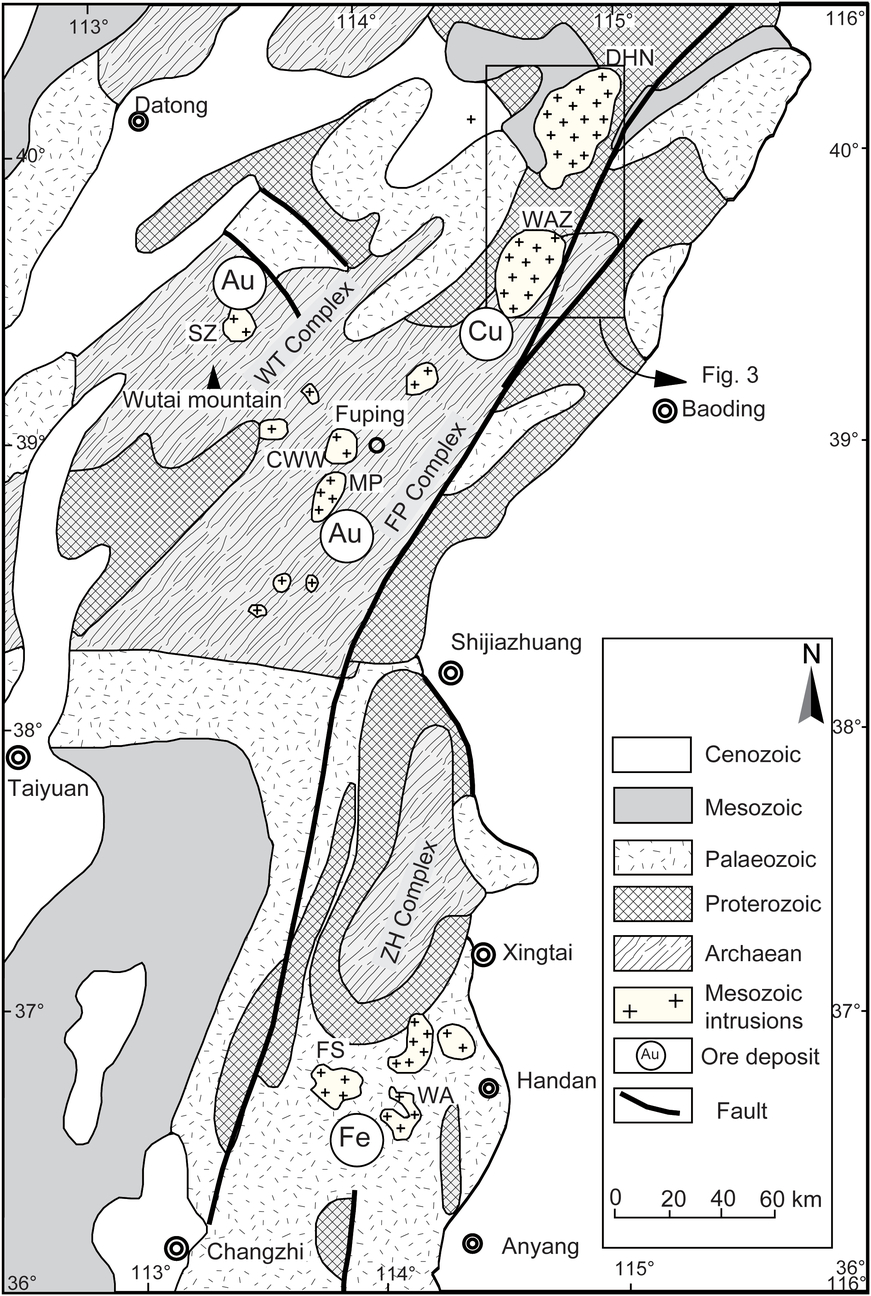
The Taihang Mountain Belt is a NNE-trending structural and magmatic belt that is 50–150 km wide and 700 km long (Fig. 1). Most of the crystalline basement of the Taihang Mountain Belt is composed of Archaean – Lower Proterozoic metamorphic rocks including gneiss and quartz–schist, which is covered by Upper Proterozoic – Cambrian–Ordovician limestones and sandstones. The eastern flank of the Taihang Mountain Belt contains the Fuping and Zanhuang Complexes (Trap et al. Reference Trap, Faure, Bruguier and Monié2008, Reference Trap, Faure, Monié, Meffre and Melleton2009); these two notable NE-trending dome structures date to the Middle Archaean – Early Proterozoic (Fig. 2; Guan et al. Reference Guan, Sun, Wilde, Zhou and Zhai2002). Carboniferous–Permian strata are characterized by coal-bearing sediments. Mesozoic strata such as Triassic fluvial sediments, Jurassic volcanic rocks and Cretaceous sediments are only locally exposed, while Cenozoic sediments are lacking in this belt (Figs 2, 3; SR Li et al. Reference Li, Santosh, Zhang, Shen, Dong, Wang and Zhang2013; Wang et al. Reference Wang, Zhou, Liu, Li and Yang2018).
Geologic map of the Taihang Mountains (modified after SR Li et al. Reference Li, Santosh, Zhang, Shen, Dong, Wang and Zhang2013), including the Archaean Wutai, Fuping, and Zanhuang complexes. Abbreviated symbols for the Mesozoic intrusions: DHN – Dahenan pluton; WAZ – Wang’anzhen pluton; SZ – Sunzhuang pluton; CWW – Chiwawu pluton; MP – Mapeng pluton; FS – Fushan pluton; and WA – Wu’an pluton.

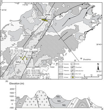
(a) Geologic map of the North Taihang Mountains with (U–Th)/He sampling locations with (b) cross section A-A’. Age data for the Wang’anzhen pluton are from Wang & Li (Reference Wang and Li2008). DHN: Dahenan pluton; and WAZ: Wang’anzhen pluton.

Mesozoic granitic and mafic plutons are widely exposed along the Taihang Mountain Belt (Fig. 2), and most of these plutons are genetically related to the polymetallic mineralization (Fig. 2; Wang & Li, Reference Wang and Li2008; Liu et al. Reference Liu, Chen, Suzuki and Liu2010; Dong et al. Reference Dong, Santosh, Li, Shen, Mo, Scott, Qu and Wang2013; Gao et al. Reference Gao, Santosh, Wei, Ma, Chen and Wu2013; SR Li et al. Reference Li, Santosh, Zhang, Shen, Dong, Wang and Zhang2013; Hou et al. Reference Hou, Li, Gao, Lu, Yang, Wang and Shen2015; Zhang et al. Reference Zhang, Li, Santosh, Li, Niu, Li, Zhang and Jia2015; S Liu et al. Reference Liu, Feng, Feng, Xu, Coulson, Guo, Guo, Peng and Feng2017). The Dahenan granitic pluton, a NNE-trending multi-stage intrusive body, is located at the northern end of the Taihang Mountain Belt (Fig. 3) and has a total exposed area of c. 760 km2. The oldest and youngest strata intruded by the Dahenan pluton are the Archaean Fuping complex and Upper Jurassic Donglingtai volcanic rocks respectively (HBGMR, 1989). Zircon U–Pb ages of 127 ± 2.7 Ma (Chen et al. Reference Chen, Tian, Zhai and Arakawa2005) and 136 Ma (Davis et al. Reference Davis, Qian, Zheng, Yu, Wang, Mao, Gehrels, Muhammad, Fryxell, Yin and Harrison1996) indicate that the Dahenan pluton was emplaced during the Early Cretaceous. The Wang’anzhen pluton, located c. 30 km south of the Dahenan pluton (Fig. 3), is an intermediate-acidic granitic complex composed primarily of granite and granodiorite (Wang & Li, Reference Wang and Li2008). Zircon U–Pb ages of 145–128 Ma (Chen et al. Reference Chen, Tian, Zhai and Arakawa2005; Wang & Li, Reference Wang and Li2008; HD Zhang et al. Reference Zhang, Liu, Wang, Zhang, Hu, Wang and Han2016) and 40Ar/39Ar ages of 140–120 Ma (Wang & Li, Reference Wang and Li2008) suggest that the Wang’anzhen pluton emplacement timing was similar to that of the Dahenan pluton.
3. Analytical procedures
We collected eight samples from the Dahenan granitic pluton (630−1584 m, TQS-1 to TQS-8; Fig. 3) and two samples from the Wang’anzhen granitic pluton to the south of Dahenan pluton (TH-11 and TH-12; Fig. 3).
Zircon and apatite crystals were separated in rock-mineral preparation in the analysis laboratory of the Institute of Geology and Geophysics, Chinese Academy of Sciences (IGGCAS). Samples of 0.5–1 kg were crushed, sieved and then washed on a concentration table to remove the lighter minerals. The resultant heavy fraction was then passed through a magnet to remove all the magnetic minerals. Finally, dozens of zircon and apatite grains were handpicked for (U–Th)/He analysis. Single grains were carefully inspected under a microscope in order to avoid grains with visible inclusions and internal fractures. Two to six single crystal aliquots were prepared per sample. In order to apply the FT correction (Farley et al. Reference Farley, Wolf and Silver1996), we measured the length and width for each grain, and a photo record was collected for each grain.
Zircon and apatite (U–Th)/He dating was carried out in the 40Ar/39Ar and (U–Th)/He geochronology laboratory of IGGCAS. Helium measurements were conducted on an Alphachron MK II quadrupole mass spectrometer (Australian Scientific Instrument Pty Limited). Each grain was wrapped in a 1 mm × 1 mm niobium (zircon) or platinum (apatite) capsule and then loaded into a 25-hole sample disc. Single grain samples were heated using a diode laser at 1100 °C for 15 min (zircon) or 950 °C for 10 min (apatite). A second heating run releasing an amount of gas comparable to that of the hot blank guaranteed the complete extraction of the helium from most crystals. The amount of helium was determined by isotopic dilution using known aliquots of well-calibrated 4He shots (Wu et al. Reference Wu, Monié, Wang, Lin, Ji, Bonno, Münch and Wang2016).
After helium extraction, the grains were retrieved and dissolved in acid for uranium (U) and thorium (Th) analysis. For zircon dissolution, standard bombing and evaporating procedures were adopted (Evans et al. Reference Evans, Byrne, Keegan and Dotter2005; Wu et al. Reference Wu, Monié, Wang, Lin, Ji and Yang2018). Apatite grains were spiked and dissolved in concentrated HNO3, and a 350 μl solution was prepared for U–Th analysis (Wu et al. Reference Wu, Monié, Wang, Lin, Ji, Bonno, Münch and Wang2016). The dissolved samples were measured with a Thermo Fisher X-Series II inductively coupled plasma mass spectrometer (ICP-MS) and suitable parameters were chosen (Wu et al. Reference Wu, Monié, Wang, Lin, Ji and Yang2018). Helium ages were calculated by a java-based program Helioplot (Vermeesch, Reference Vermeesch2010) and corrected for alpha ejection following the procedure of Gautheron & Tassan-Got, (Reference Gautheron and Tassan-Got2010). Two sources of error contribute to the uncorrected single crystal helium age: the 4He analytical error and the parent concentration analytical error. Uncertainties related to 4He measurement (~1.5 %) include errors of the standard gas, the blank measurement, and the 4He/3He ratios of the standard gas and the sample. Uncertainties on U and Th (1–2 %) measurement consist of errors of pipette volume, isotopic ratio of the standard solution and the spike, and the existing isotopic ratios during the ICP-MS measurements. After propagating the aforementioned uncertainties through the calculations to arrive at the final age values, we determined that the total single crystal age uncertainty is 2−3 %.
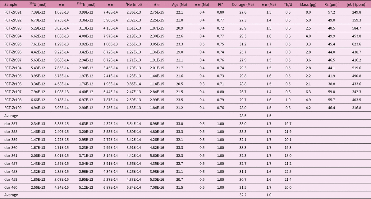
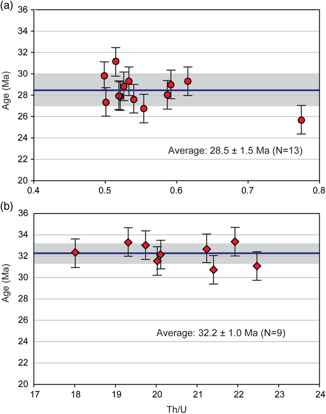
We validated our analytical techniques using zircon (Fish Canyon Tuff, FCT) and apatite (Durango) reference standards. Our analysis of 13 FCT zircon grains yielded (U–Th)/He ages of 25.7−29.8 Ma (Table 1), with an average of 28.5 ± 1.5 Ma (1σ; Table 1; Fig. 4), which is consistent with the published age data from other helium laboratories (McDowell et al. Reference McDowell, McIntosh and Farley2005; Reiners & Nicolescu, Reference Reiners and Nicolescu2006). Furthermore, our analyses of 14 Durango fragments (100−150 μm) yielded (U–Th)/He ages of 30.7−33.3 Ma (Table 1), with an average of 32.2 ± 1.0 Ma (1σ; Table 1; Fig. 4); these results were consistent with the reported age of 31.9 ± 1.0 Ma (1σ) (Reiners & Nicolescu, Reference Reiners and Nicolescu2006).
(U–Th)/He analytical results for the reference standard zircon and apatite samples

* Ft calculated based on Gautheron & Tassan-Got (Reference Gautheron and Tassan-Got2010).
† Rs is the equivalent spheric radius.
‡ [eU] = [U] + 0.235 * [Th]
(U–Th)/He age results for the reference standards (a) Fish Canyon zircon; and (b) Durango apatite.

4. Results
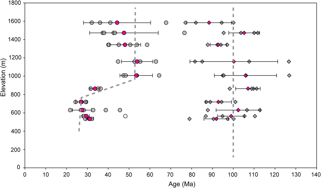
Our results reveal single grain zircon (U–Th)/He ages ranging from 77.1 to 126.9 Ma (Fig. 5; Tables 2, 3). The average ages of four grains from each sample range from 88.4 ± 10.7 Ma (1σ) (TQS-1) to 107.1 ± 5.9 Ma (1σ) (TQS-6). The average ages for all eight samples fall within one another’s 1σ error, which indicates that the c. 1 km granitic column represented by the vertical transect cooled rapidly during the end of the Early Cretaceous (~100 Ma).
(U–Th)/He age results for our zircon (diamonds) and apatite (circles) samples located along the vertical transect. Grey symbols represent single crystal ages where the blank ones have been rejected; pink symbols represent the average ages of several crystals.

(U–Th)/He analytical results for samples in the vertical transect in the Dahenan pluton

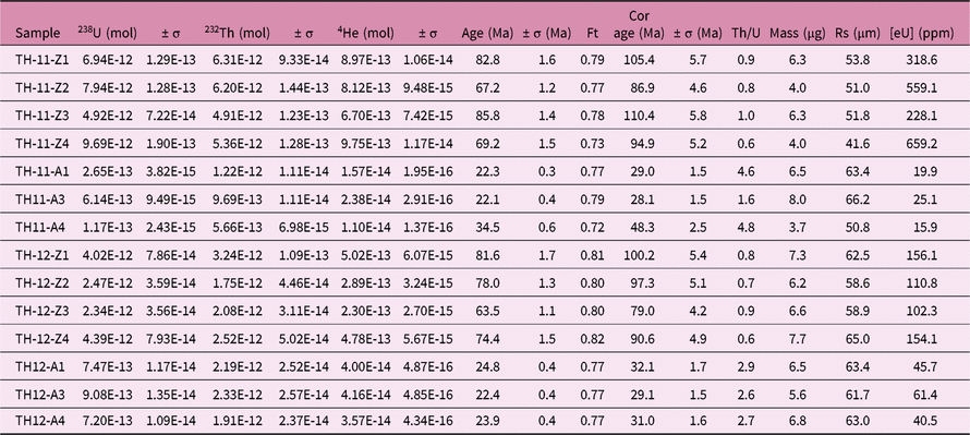
(U–Th)/He analytical results for the Wang’anzhen pluton

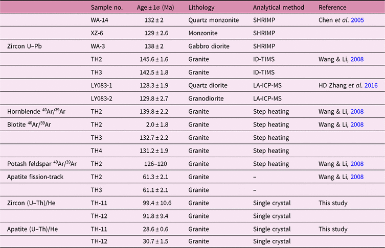
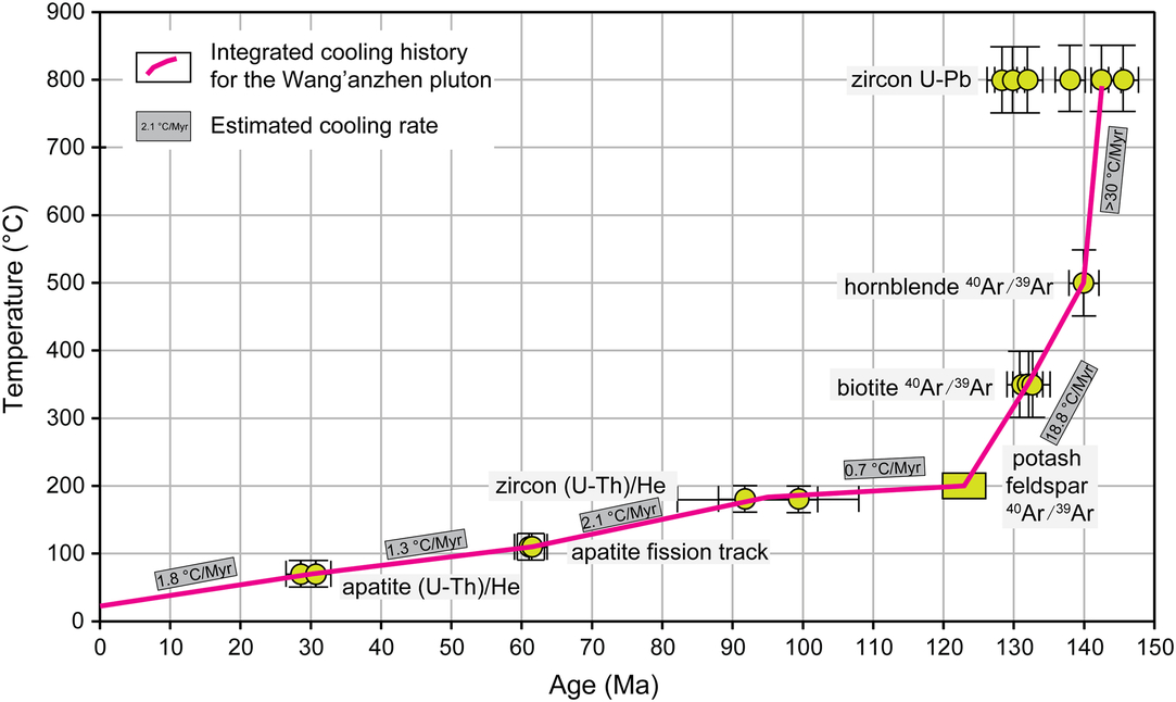
Single grain apatite (U–Th)/He ages range from 21.8 to 76.6 Ma (Fig. 5; Tables 2, 3). The average ages of five samples with elevations above 1000 m (TQS-1 to TQS-5) are consistent within error although the first two samples have larger age variations than the other samples (Table 2). The average ages are increasingly young at elevations below 1000 m, with an age of 33 Ma at 864 m, and an age of 26.9 Ma at 719 m. Four samples have identical average ages of 27 Ma, which suggests that another rapid cooling phase started at about that time. Taken all together, the integrated age–elevation profile reveals that the Taihang Mountain Belt cooled in three phases (Fig. 5), where the first phase occurred during the Early Cretaceous (~100 Ma), the second phase occurred during the Eocene (50−40 Ma) and the third phase occurred during the Oligocene–Miocene (~27 Ma). To provide additional context, we combined cooling curves with published U–Pb, 40Ar/39Ar and fission track ages (Table 4) to reconstruct the thermal history of these geological bodies. The integrated cooling curve (Fig. 6) consists of subsets of data provided by different thermochrometers, where each section was estimated by dividing the closure temperature difference of neighbouring isotopic systems by their age difference. By employing this method with the samples for the Wang’anzhen pluton (Fig. 6), we confirmed the existence of the first and the third rapid cooling phases observed in the vertical transect.
Age summary of the samples in the Wang’anzhen pluton

SHRIMP: sensitive high-resolution ion microprobe; ID-TIMS: isotope dilution thermal ionization mass spectrometer; LA-ICP-MS: laser ablation inductivelycoupled plasma mass spectrometer
Reconstructed multi-thermochrometer cooling history for the Wang’an pluton (data from Chen et al. (Reference Chen, Tian, Zhai and Arakawa2005); Wang & Li (Reference Wang and Li2008); HD Zhang et al. (Reference Zhang, Liu, Wang, Zhang, Hu, Wang and Han2016); and this study).

5. Discussion
5.1 Uplift history of the Taihang Mountains
Since the Late Ordovician to the Late Carboniferous (445–315 Ma), multi-phase uplift and erosion occurred in the southern and northern margins of the NCC, which may be related to the observed crustal deformation and to the tectonic transformation and finally resulted in the destruction and/or lithospheric thinning of the NCC (Wang et al. Reference Wang, Zhou, Liu, Li and Yang2018). Based on the structural analysis and radiometric (U–Pb, 40Ar/39Ar and apatite fission track) ages, Wang & Li (Reference Wang and Li2008) concluded that the Taihang Mountain Belt initially formed during the Jurassic (175–150 Ma) and subsequently experienced additional uplift/exhumation during the Early Cretaceous (146–125 Ma) and Early Cenozoic (70 Ma). Some studies have been carried out on the low-temperature evolution of the Taihang Mountain Belt through fission track thermochronology (Zhang et al. Reference Zhang, Xu, Wang and Guo2002; Qing et al. Reference Qing, Ji, Wang, Peng, Niu and Ge2008; Cao et al. Reference Cao, Li, Xu, Guo, Liu, Zhao, Liu and Dai2015; SB Li et al. Reference Li, Wang, Zhang, Zhang, Liang and Qiu2015; Meng et al. Reference Meng, Wang and Chen2015; Zhao et al. Reference Zhao, Liu, Mountney, Lu, Cao, Yang and Xue2015; Chang et al. Reference Chang, Qiu, Liu, Cai, Xu and Liu2019). Zhang et al. (Reference Zhang, Xu, Wang and Guo2002) recognized two phases of relatively rapid cooling at 68–52 Ma and 23–18 Ma respectively, based on apatite and zircon fission track ages from a detachment fault zone between the Taihang Mountain Belt and the North China Basin. In the central part of the Taihang Mountain Belt (Wutai and Fuping complexes), multiple phases of rapid cooling (Late Cretaceous, Eocene and Miocene) were recognized by other authors (Qing et al. Reference Qing, Ji, Wang, Peng, Niu and Ge2008; Chang et al. Reference Chang, Qiu, Liu, Cai, Xu and Liu2019). Similar Cenozoic rapid cooling phases were also found in the southern Taihang Mountain Belt (Cao et al. Reference Cao, Li, Xu, Guo, Liu, Zhao, Liu and Dai2015; SB Li et al. Reference Li, Wang, Zhang, Zhang, Liang and Qiu2015; Meng et al. Reference Meng, Wang and Chen2015) and the Lvliang Mountains (Zhao et al. Reference Zhao, Liu, Mountney, Lu, Cao, Yang and Xue2015).
In this study, three rapid cooling phases were recognized by zircon and apatite (U–Th)/He results on a single vertical transect on the northern Taihang Mountain Belt (Fig. 5). The late Early Cretaceous (~100 Ma) rapid cooling/uplifting is characterized by nearly identical zircon (U–Th)/He ages spanning an elevation range between 1584 and 630 m (Fig. 5; Table 2). During the Triassic, sedimentation in the Qinshui Basin (Fig. 1) on the west of the Taihang Mountain Belt and in the eastern margin of the Ordos Basin was characterized by a lacustrine environment, implying that the study area was not experiencing uplift at that time. U–Pb–Hf isotope analyses of detrital zircons from Late Triassic – Jurassic sediments in the Ordos, Ningwu and Jiyuan basins in the western-central NCC (Li & Huang Reference Li and Huang2013; HY Li et al. Reference Li, Xu, Liu, Huang and He2013) suggest uplift of the orogens surrounding the NCC and subsidence of the eastern-central NCC in the Triassic–Jurassic and low elevation in the Taihang Mountains. However, the Upper Jurassic and Upper Cretaceous sediments are only locally exposed in some intermontane basins in the northern part of the Taihang Mountain Belt, suggesting that the Taihang Mountain Belt was initially uplifted during the Middle Jurassic, a conclusion consistent with that drawn by Wang & Li (Reference Wang and Li2008).
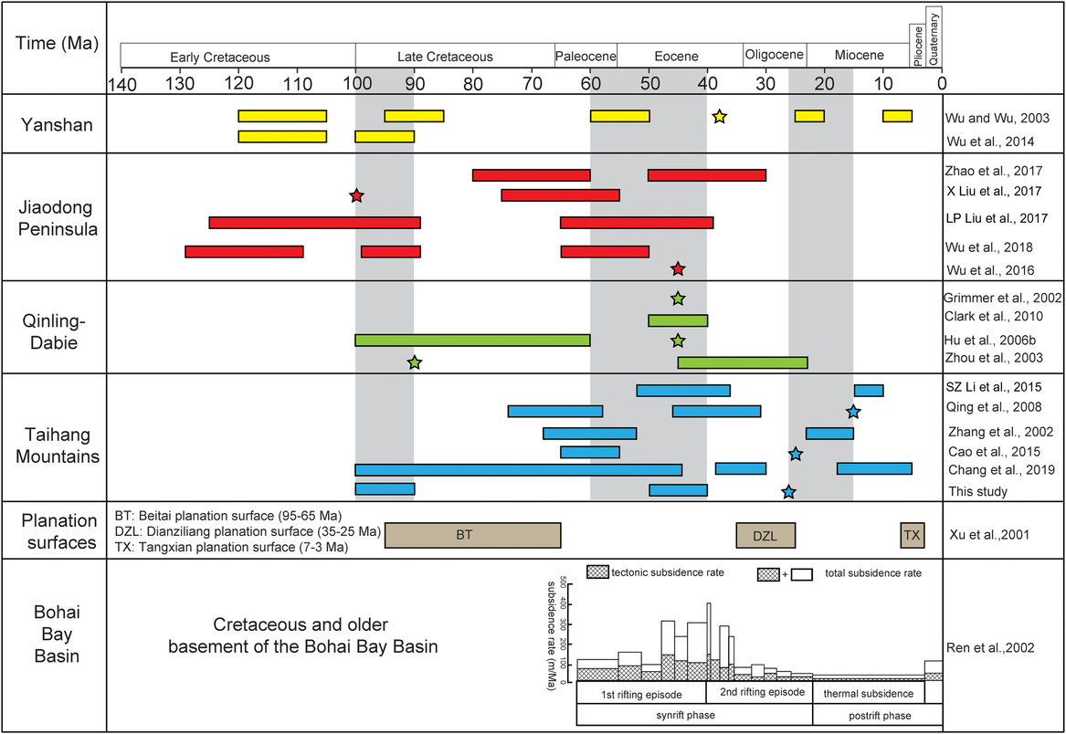
Similarly, because the Late Cretaceous sedimentation only exists in marginal regions of the NCC, including the Tan–Lu Fault Zone, the Jiaolai Basin and the Fuxin Basin (Wu et al. Reference Wu, Wang, Lin, Wang, Yang, Shi and Feng2014), we infer that the previously uplifted NCC was subjected to erosion during the Late Cretaceous. Previous work in the Yanshan fold-and-thrust belt (ZH Wu et al. Reference Wu, Cui, Zhu and Feng1999, Reference Wu, Cui, Wu, Zhu, Feng and Ma2000; Wu & Wu, Reference Wu and Wu2003; Wu et al. Reference Wu, Wang, Lin, Wang, Yang, Shi and Feng2014) and the Jiaodong Peninsula (LP Liu et al. Reference Liu, Li, Danišík, Li, Evans, Jourdan and Tao2017; X Liu et al. Reference Liu, Fan, Evans, Yang, Danišík, McInnes, Qin and Yu2017; Sun et al. Reference Sun, Li, Liu, Chen, Yang and Wu2017; Wu et al. Reference Wu, Monié, Wang, Lin, Ji and Yang2018) has also provided evidence for the late Early Cretaceous rapid cooling, implying that this cooling/uplifting was a regional tectonic event, rather than a local event centred on our study area. This event was attributed to a sedimentary hiatus or an angular unconformity, known as a basin inversion, which occurred between 100 and 90 Ma (Sun et al. Reference Sun, Li, Liu, Chen, Yang and Wu2017 and references therein). After this cooling/uplifting event, the NCC entered an erosional stage during the Late Cretaceous and formed the Beitai planation surface (Fig. 7; Xu et al. Reference Xu, Gao, Sun and Song2001). The Beitai planation surface, which has an average elevation of 3000 m, was preserved in the Taihang Mountain Belt, the Lvliang Mountains, and the Yanshan Mountain Belt. As a result, the entirety of the eastern NCC was considered to be the North China peneplain.
Basin–mountain coupling relationship for the Bohai Bay Basin and the surrounding mountains, including the Yanshan (yellow), Jiaodong (red), Qinling–Dabie (green) and Taihang (blue) regions. Rectangles represent rapid cooling phases with long durations, and stars represent rapid cooling phases with short time intervals.

The second rapid cooling phase, which was revealed by the indistinguishable apatite He ages for the five uppermost samples in the vertical transect (Fig. 5; Table 2), occurred during the Early Cenozoic. This cooling phase resulted in a minimum total exhumation of 0.6 km (i.e. the elevation difference between samples TQS-1 and TQS-5), which is similar to the amount estimated by Cao et al. (Reference Cao, Li, Xu, Guo, Liu, Zhao, Liu and Dai2015). The Early Cenozoic rapid uplift was widespread; evidence of this uplift period can be found in the mountains around the Bohai Bay Basin (Fig. 7), including the Taihang Mountain Belt (Zhang et al. Reference Zhang, Xu, Wang and Guo2002; Qing et al. Reference Qing, Ji, Wang, Peng, Niu and Ge2008; Cao et al. Reference Cao, Li, Xu, Guo, Liu, Zhao, Liu and Dai2015; SB Li et al. Reference Li, Wang, Zhang, Zhang, Liang and Qiu2015; Meng et al. Reference Meng, Wang and Chen2015; Zhao et al. Reference Zhao, Liu, Mountney, Lu, Cao, Yang and Xue2015; this study), the Qinling–Dabie–Sulu orogenic belt (Grimmer et al. Reference Grimmer, Jonckheere, Enkelmann, Ratschbacher, Hacker, Blythe, Wanger, Wu, Liu and Dong2002; Zhou et al. Reference Zhou, Xu, Reiners, Yang and Donelick2003; Hu et al. Reference Hu, Kohn, Raza, Wang and Gleadow2006a, b; Clark et al. Reference Clark, Farley, Zheng, Wang and Duvall2010; Wu et al. Reference Wu, Monié, Wang, Lin, Ji, Bonno, Münch and Wang2016, Reference Wu, Monié, Wang, Lin, Ji and Yang2018; Zhao et al. Reference Zhao, Wang, Liu, Santosh, Yuan and Wang2017), the western Shandong block (Li & Zhong, Reference Li and Zhong2006), the Liaodong Peninsula (Wang et al. Reference Wang, Zhou, Liu, Li and Yang2018) and the Yanshan fold-and-thrust belt (ZH Wu et al. Reference Wu, Cui, Zhu and Feng1999, 2000; Wu & Wu, Reference Wu and Wu2003). At the beginning of the Cenozoic, some NNE-trending thrust and strike-slip faults (e.g. the Taihang Mountain Fault and the Tan–Lu Fault) were reactivated as normal faults (Mercier et al. Reference Mercier, Hou, Vergély and Wang2007, Reference Mercier, Vergely, Zhang, Hou, Bellier and Wang2013; Wang & Li, Reference Wang and Li2008; Wang & Zhou, Reference Wang and Zhou2009; Wang et al. Reference Wang, Zhou, Liu, Li and Yang2018) and caused the initial rifting of the Bohai Bay Basin. The North China peneplain broke up, which led to the formation of the Bohai Bay Basin as the footwall of the Taihang Mountain fault, and the uplift of the Taihang Mountain Belt as the hanging wall (Xu et al. Reference Xu, Gao, Sun and Song2001). The Early Cenozoic sedimentation in the Bohai Bay Basin (including the Kongdian Formation, the Shahejie Formation and the Dongying Formation), which has a layer thickness of 3000−5000 m, displays an abrupt topographic change of 2000 m between the Taihang Mountain Belt and the Bohai Bay Basin; this rapid elevation change suggests that the Taihang Mountain normal faults controlled the formation of the basin and the Cenozoic uplift of the Taihang Mountains. The total subsidence rate in the Bohai Bay Basin reached maximum during the Eocene (Fig. 7). The Dianziliang planation surface formed after this rapid uplift event in the Taihang Mountain Belt (Fig. 7).
We found evidence for the third rapid cooling phase, which took place during the Late Oligocene (~27 Ma) and caused a total exhumation of c. 0.2 km, in the two samples with the lowest elevation (TQS-7 and TQS-8), as well as in one Wang’anzhen pluton sample (Fig. 7). The approximate total exhumation caused by this uplifting was 0.2 km. The multi-thermochrometer T-t path of the Wang’anzhen pluton also yielded information about this cooling phase: the average cooling rate increased from 1.0°C Ma−1 to 1.8°C Ma−1 at c. 27 Ma (Fig. 6). At the end of the Palaeogene, the rifting process terminated in the Bohai Bay Basin and was followed by a regional compressional deformation event, which resulted in a regional unconformity between the Palaeogene and Neogene sediments in the Bohai Bay Basin (Ren et al. Reference Ren, Tamaki, Li and Zhang2002). Starting from the early Miocene, the Bohai Bay Basin was subjected to thermal subsidence on a regional scale and eventually became a depression basin (Ren et al. Reference Ren, Tamaki, Li and Zhang2002; Yin, Reference Yin2010). Our results agree with a recent tectono-thermal history reconstruction by Chang et al. (Reference Chang, Qiu, Zhao, Shen, Liu and Liu2018), which discusses the Late Eocene heat flow peaks of ~80 mW m−2 and subsequent Middle Eocene – Early Miocene (43–23 Ma) rapid cooling in the western Bohai Bay Basin. Previous work also agrees with our observations that both the south and north part of the Taihang Mountain Belt experienced rapid uplift during this cooling stage (Zhang et al. Reference Zhang, Xu, Wang and Guo2002; Qing et al. Reference Qing, Ji, Wang, Peng, Niu and Ge2008; Cao et al. Reference Cao, Li, Xu, Guo, Liu, Zhao, Liu and Dai2015; SB Li et al. Reference Li, Wang, Zhang, Zhang, Liang and Qiu2015; Meng et al. Reference Meng, Wang and Chen2015; Zhao et al. Reference Zhao, Liu, Mountney, Lu, Cao, Yang and Xue2015).
5.2 Tectonic implications
The Central Asian (Xiao et al. Reference Xiao, Windley, Badarch, Sun, Li, Qin and Wang2004, Reference Xiao, Li, Santosh and Jahn2012), the Pacific (Müller et al. Reference Müller, Sdrolias, Gaina, Steinberger and Heine2008) and the Tethys tectonic systems (Liu et al. Reference Liu, Cui and Liu2004) have been driving crustal deformation and differential uplift of eastern Asian continental blocks since the Mesozoic. In the Triassic, the motion of these plates created the Qinling–Dabie–Sulu orogenic belt (Mattauer et al. Reference Mattauer, Matte, Malavieille, Tapponnier, Maluski, Xu, Lu and Tang1985; Xu et al. Reference Xu, Zhu, Tong, Cui and Liu1987; Ames et al. Reference Ames, Tilton and Zhou1993, Reference Ames, Zhou and Xiong1996; Li et al. Reference Li, Xiao, Liu, Chen, Ge, Zhang, Sun, Cong, Zhang, Hart and Wang1993; Hacker et al. Reference Hacker, Wallis, Ratschbacher, Grove and Gehrels2006) to the south and caused the closure of the Mongolia–Okhotsk ocean to the north (Xiao et al. Reference Xiao, Windley, Badarch, Sun, Li, Qin and Wang2004, Reference Xiao, Li, Santosh and Jahn2012). The NCC experienced intensive contraction across the Yanshan tectonic belt (Davis et al. Reference Davis, Wang, Zheng, Zhang, Zhang and Gehrels1998, Reference Davis, Zheng, Wang, Darby, Zhang, Gehrels, Hendrix and Davis2001; Zhang et al. Reference Zhang, Li, Deng, Liu, Liu, Wei, Li and Liu2011) and the Taihang Mountain and Inner Mongolia belts (Wang et al. Reference Wang, Zhou, Liu, Li and Yang2018) in the Late Jurassic, large-scale crustal/lithospheric extension throughout the Early Cretaceous (T Wang et al. Reference Wang, Zheng, Zhang, Zeng, Donskaya, Guo and Li2011, Reference Wang, Guo, Zheng, Donskaya, Gladkochub, Zeng, Li, Wang and Mazukabzov2012; Zhu et al. Reference Zhu, Chen, Wu and Liu2011; Lin et al. Reference Lin, Faure, Chen, Ji, Wang, Wu, Charles, Wang and Wang2013a and references therein) and basin/mountain formation during the Cenozoic (Meng, Reference Meng2003; SZ Li et al. Reference Li, Suo, Santosh, Dai, Liu, Yu, Zhao and Jin2013, 2015; Chang et al. Reference Chang, Qiu, Zhao, Shen, Liu and Liu2018).
At the end of the Late Cretaceous (~100 Ma), sedimentary records of an intensive ‘basin inversion’ event known as the third episode of the ‘Yanshan Movement’ have been widely documented in the eastern NCC (Wu et al. Reference Wu, Monié, Wang, Lin, Ji and Yang2018 and references therein). The geodynamic regime for this short-lived Early–Late Cretaceous boundary event might be attributed to the collision between the west-northwestward-moving Okhotomorsk Block and the East Asian continental margin (~100 Ma) (Yang, Reference Yang2013). This collision event resulted in the rapid uplift and exhumation of major mountains and basins along the East Asian continental margin (e.g. the Jiaolai Basin (LM Zhang et al. Reference Zhang, Wang, Cao, Wang, Tan and Gao2016), the Yanshan Belt (Wu et al. Reference Wu, Wang, Lin, Wang, Yang, Shi and Feng2014), the Taihang Mountains (SB Li et al. Reference Li, Wang, Zhang, Zhang, Liang and Qiu2015; Chang et al. Reference Chang, Qiu, Liu, Cai, Xu and Liu2019; this study)) and fault reactivation (Zhang et al. Reference Zhang, Xu, Wang and Guo2002; Wang & Zhou, Reference Wang and Zhou2009).
Cenozoic tectonics in the NCC developed on the pre-existing tectonic framework which was built up during the Mesozoic (SZ Li et al. Reference Li, Suo, Santosh, Dai, Liu, Yu, Zhao and Jin2013) and was characterized by differential uplift of fault-bounded blocks (Zhang et al. Reference Zhang, Xu, Wang and Guo2002; Qing et al. Reference Qing, Ji, Wang, Peng, Niu and Ge2008; Cao et al. Reference Cao, Li, Xu, Guo, Liu, Zhao, Liu and Dai2015; Li & Zhong, Reference Li and Zhong2006; SZ Li et al. Reference Li, Guo, Xu, Somerville, Cao, Yu, Wang, Suo, Liu and Zhao2015; Meng et al. Reference Meng, Wang and Chen2015; Zhao et al. Reference Zhao, Liu, Mountney, Lu, Cao, Yang and Xue2015; Wu et al. Reference Wu, Monié, Wang, Lin, Ji, Bonno, Münch and Wang2016, Reference Wu, Monié, Wang, Lin, Ji and Yang2018) and basin subsidence (Ren et al. Reference Ren, Tamaki, Li and Zhang2002). During the Cenozoic, the most prominent plate convergence around the NCC was India–Asia continental collision and Pacific Plate subduction beneath the Eurasia continent. Wu et al. (Reference Wu, Monié, Wang, Lin, Ji, Bonno, Münch and Wang2016) summarized the main early Cenozoic rapid cooling events in the NCC and its adjacent regions and found that most of these events distributed along large-scale strike-slip boundary faults. They inferred that combined effects of India–Asia continental collision and change of subduction direction and convergence rate of the Pacific Plate might account for these rapid cooling events (Wu et al. Reference Wu, Monié, Wang, Lin, Ji, Bonno, Münch and Wang2016, Reference Wu, Monié, Wang, Lin, Ji and Yang2018). This hypothesis was also supported by layered seismic tomographic images of the NCC and adjacent areas at different depths shown by Tian et al. (Reference Tian, Zhao, Sun and Teng2009), in which they recognized a N–S-trending anomaly at shallow depth (parallel to the eastern margin of the Tibet Plateau) and NE-trending anomaly at 300 km depth (correlated with the subduction of the Pacific Plate).
6. Conclusions
Based on zircon and apatite (U–Th)/He thermochronological data from samples taken from a vertical transect from the Early Cretaceous Dahenan granitic pluton and multi-thermochrometer data from the nearby Wang’anzhen pluton, we created a detailed timeline of thermal evolution of the northern Taihang Mountains. Since 100 Ma, we conclude that the NCC has experienced three phases of rapid cooling during the Early Cretaceous (~100 Ma), the Eocene (50−40 Ma) and the Oligocene–Miocene (27 Ma). Evidence for these rapid cooling phases, in the form of planation surfaces that form after each rapid cooling/uplift event, is widely distributed amongst the mountains around the Bohai Bay Basin, including the Yanshan fold-and-thrust belt to the north, the Jiaodong Peninsula to the east, the Qinling–Dabie Mountains to the south, and the Taihang Mountain Belt to the west. This coupling relationship between mountain belts and basin evolution verified that they are controlled by a unified geodynamic setting, affected by the interaction between the Eastern Block of the NCC and its surrounding terranes.
Acknowledgements
This study is jointly funded by Ministry of Science and Technology of the People’s Republic of China (2016YFC0600109) and the National Natural Science Foundation of China (41503055, 41673015 and 41773045). We gratefully acknowledge the detailed and constructive comments by Prof. Michel Faure and an anonymous reviewer, which considerably improved the manuscript. Dr Qian Guo was appreciated for her help during the mineral separation. Desmond Patterson provided tremendous help during the establishment of the (U–Th)/He laboratory of IGGCAS. Noreen J. Evans from Curtin University is thanked for valuable suggestions that improved the standard procedure of helium dating.