

Introduction
In 1900 a member of the Historical Society of Southern California sought to explain the recent transformation of Los Angeles from a ‘sleepy Spanish-Mexican pueblo’ into a ‘modern, bustling, up-to-date metropolis’. In doing so, Mary Mooney evoked the ‘sweeping changes wrought by industry and capital’.Footnote 1 Mooney was not alone. When Americans assessed the nature and pace of change in cities at the turn of the twentieth century they often began with the effects of industrial capitalism. Their accounts have shaped our histories. Scholars talk of corporations and mass production, of integration and enhanced efficiency, of wage labour and its social reproduction, of political malfeasance and social reform when interpreting urban economies and the growth of cities. Economic geographers, political scientists and urban theorists have studied these processes at a high level of abstraction in a search for fundamental laws that might explain ‘sweeping changes’. Social historians, urban sociologists and historical geographers have conducted micro-studies of neighbourhood and community, of demographic dynamism, social segregation and the processes by which race-ethnic groups cycle through localities and transform space into place, of the workplace and social worlds in order to portray everyday life in the ‘modern, bustling metropolis’.Footnote 2
This study, a micro-history of urban economic development, borrows from both traditions. A case study of the Cudahy Packing Company (Cudahy or Cudahy Co.) reveals how enterprisers, business associations, elected officials and residents established a production landscape in Los Angeles during the 1890s. The emphasis is on political alliances and the politics of land use, on a municipal corporation using its assets and resources to attract investment and on how the local state and citizens created location formally, via regulation, and informally, via an association of people deemed lower with precincts perceived as heterogeneous and disordered. An analysis of contests over land use and the allocation of municipal capital, and debates over public finance and the costs and benefits associated with specific industries, allows historians to articulate macro-scale processes such as capital flows and industrial location. Examining municipal enterprise in turn-of-the-twentieth-century Los Angeles offers new perspectives on the political forces that produce location. It also provides a historical framework for current discussions about joint public–private initiatives and theories of a ‘third way’, a reworking of arrangements among states, the for-profit private sector, non-profits and NGOs (non-government organizations). With the exception of federal investment during World War II, enterprise in southern California has been and continues to be seen as private sector initiative. When the local state appears it has been as a handmaiden, or a rubber stamp. The exception has been Steven P. Erie's studies of the ‘crown jewels’ – the Department of Water and Power, the Ports of Los Angeles/San Pedro and the Department of Airports – proprietary agencies that made possible growth in territory, population and production. Though Erie has brought the local state into Los Angeles history it has been at a single scale and at a singular moment, the apex of Progressive reforms.Footnote 3
Los Angeles emerged as an industrial city at a time when civic officials were creating agencies and instituting regulations associated with the modern state. These processes were entwined. Many ordinances, for example those pertaining to land use and the creation of discrete districts for residences and manufacturing, were enacted in response to the growing number, expanding scale and greater variety of manufactories. A succession of mayors, council members and other elected and appointed officials grew the local state in concert with enterprisers and associations of businessmen who worked to ensure the local economy had a ‘firm foundation’ in manufacturing.Footnote 4
The transformation Mooney described as an old order giving away to the new, with Anglo residents of an ‘up-to-date metropolis’ watching a ‘sleepy pueblo’ and its Spanish-Mexican or Californio population recede into the past, accords with a received wisdom that equates population growth with a subsequent growth in the production of goods and trade and both with the extension of the Southern Pacific railroad to Los Angeles in 1876 and the arrival of a competing line, the Santa Fe in 1885 (partially on SP tracks). Enhanced connections stimulated an influx of exogenous capital and encouraged place promoters who sold the ‘Southland’ as an American Mediterranean, a bastion of the open shop and a workingman's arcadia.Footnote 5
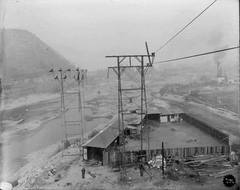
The ‘sweeping changes wrought by industry and capital’ Mooney referred to in 1900 can be examined in an area of approximately 10 square miles straddling both sides of the Los Angeles River commencing at the Plaza, extending north to Elysian Park, east to Lincoln Heights and south to present day Olympic Boulevard. Contemporaries called this the East Side Industrial District. What surprises anyone studying the site today is the centrality of its location. It is within the boundaries of the Spanish-Mexican pueblo and corresponds with the ‘metropolis’ Mooney referred to in 1900 (see Figure 1). Following the American conquest of 1848 and continuing to the 1910s, urban development occurred within a few miles of the Plaza as the descendants of Californios, Yankees and émigrés from other nations converted Spanish common land (propios) into parcels, laid out streets and altered customary patterns of land use. When they invested capital and time, approved of or challenged property boundaries, agitated for policy or municipal improvements, or built and repurposed structures for housing, commerce and production their actions were constrained by the past: by property boundaries and traditions of usufruct (use rights), by the physical presence of structures placed according to previous patterns of ownership and use.Footnote 6
View to the north showing the Los Angeles River, Atchison, Topeka & Santa Fe railroad tracks, Southern California Edison transmission lines and various manufactories taken from a point just north of the junction of Aliso Street and the river. A Los Angeles Gas Co. storage tank is just visible in the foreground. In the middle distance the photographer recorded a Cudahy Packing Company sign on one of its structures. Note the advertisement for Coca-Cola below the bluff formed by a levee; an indication the number of people who plied their trade in the riverbed was not insignificant.

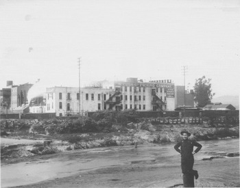
They produced a heterogeneous landscape: of house courts and rooming houses intermixed with freight yards and ironworks; of production cheek-by-jowl with the city's finest hotels and commercial blocks; all within a few blocks of the Plaza and City Hall. Reformers, social workers and public health officials viewed this district as chaotic and disorderly. Contemporary sources reveal it to have been organized by networks of trade, by proximity to employment, by access to materials, parts and other production inputs. It was akin to what historians, geographers and sociologists have detailed in New York and Chicago, Philadelphia and St Louis.Footnote 7 Some goods produced in the East Side district, such as preserved foods, travelled great distances before being consumed. Other goods, such as paper for wrapping, boxes for shipping, and cans and bottles for packing fruits, vegetables and meat, travelled a block or less. Alfalfa and other feedstock grown in the nearby San Fernando Valley fatted cattle and hogs bound for a cluster of packinghouses north of Macy Street along the Los Angeles River. Those packers transported tallow south to First Street where Los Angeles Soap Company had its plant. Bone and hooves, offal and blood were carted across the river to Agricultural Chemical Works or a half-mile down Alameda Street to Armour Fertilizer. These firms sold their products to agriculturalists who then applied fertilizer to enhance yields of alfalfa and other crops (see Figure 2).Footnote 8
View looking north of a stockade sited within the bed of the Los Angeles River just south of the confluence with the Arroyo Seco. The east flank of Elysian Park is visible on the left (the west bank). Note the works, located on land the city owned, on the right (the east bank). Cattle or hogs stored at this yard would have crossed the river and been driven south along its banks to the Cudahy, Wilson or another packing house in the district between Macy Street and Main.

Given that heterogeneity, why concentrate on slaughtering and meatpacking, a sector producing a basic consumer commodity for a local or regional market? First, a focus on cattle draws attention to continuities that link the rise of manufactures in the American city with the pueblo past. Raising livestock was one of the legacies of California's colonial era. Following secularization of the missions large landowners grew their herds to supply the hide and tallow trade which dominated Los Angeles’ export economy during the Mexican era. Following the American conquest, Californios who controlled land and cattle made considerable profit provisioning miners working the Sierra gold fields in northern California. Drought in the 1860s decimated those herds and the resulting loss was a contributing factor in the forced sale of rancho lands to squatters and subdividers. Yet climate, flora and the year-round production of feedstock in the basin favoured stock raising as did advances in refrigeration which enlarged the market for California packers.Footnote 9
Second, as an economic sector, slaughtering and meatpacking contributed significantly to the state, county and municipal economies of California and Los Angeles. The 1899 census of manufactures reported a 61 per cent increase in the value of products for slaughtering and meatpacking in the state (from $9.7 to $15.7 million) a sum that placed the sector second after the refining of sugar and molasses. Until 1930, meatpacking ranked second to fourth in value of product in California. At the city level meatpacking was a minor sector until 1900. Rapid growth over the next two decades allowed Los Angeles meatpackers to surpass their counterparts in San Francisco. From 1890, when the census of manufactures recorded six firms in wholesale slaughtering producing $725,036 in products, to 1920, when the eight firms enumerated had the highest value of products, $25,125,000, of all industries in the city, Los Angeles emerged as a manufacturing centre of the first order. When Los Angeles did overtake San Francisco as the pre-eminent industrial complex in California, a change the census bureau reported in 1929, petroleum refining, motor vehicles and foundry products had overtaken meatpacking as leading sectors. In 1939 when the Los Angeles Area Chamber of Commerce surveyed industry in the county meatpacking trailed only petroleum and aviation and bested motion pictures.Footnote 10
Third, with its attendant stockyards and slaughterhouses, rendering plants and lard houses, warehouses and shipping facilities, the modern meatpacking plant required a relatively large site for operations. Although Angelenos, like residents of other cities, viewed slaughterhouse operators as provisioners of staple commodities, the norm long had been to restrict these works to outlying sites at a remove from housing and other businesses.Footnote 11 Given the nature of the operation, the transport of bulky inputs in large numbers and the scale of plant it would be expected that civic officials might consider meatpacking a noxious or nuisance activity and that they would encourage Cudahy to construct its plant at the city's edge rather in the core area of the city. Why Cudahy chose the site it did, why the city approved this location and the implications of these decisions for those who lived in the district, and the effect Cudahy's location had on subsequent development, warrant analysis.
In association with other manufacturers Cudahy strove to define land use, to orchestrate the provision of municipal services, to shape public policy and to influence conceptions of the civic good. At times firms acted independently to ensure the passage of ordinances favourable to their objectives, to secure public improvements that would facilitate their operations, to generate support for their venture. On occasion firms shared objectives and worked in concert to pursue a shared good or to contest and resist municipal initiatives antithetical to their interests such as attempts to impose limits on water drawn from the Los Angeles River or on the disposal of waste. These associations linked proprietors and firms in political alliances with civic officials and with segments of the voting public. Legal proceedings, contracts, land titles, ordinances, council minutes and additional municipal records convey relations structured as much by uncertainty and competition as by any shared vision of the future. These records also reveal a proactive local state using its control of resources and its regulatory powers to promote an urban economy.
Cudahy Packing Company and the location of industry
The role that industry has played in the settlement of the West is often neglected or entirely ignored. . .[T]his is particularly true of the packing industry which has contributed in a substantial measure to its development.
The Cudahy Packing Company (1925)Footnote 12Michael (1841–1910) and Edward (1860–1941) Cudahy, the proprietors of Cudahy Packing Company, learned the trade in Milwaukee. Ten years on the shop floor earned Michael a management position with Philip Armour when that firm expanded its operations to Chicago. In 1887 when Armour purchased a plant in South Omaha he made Cudahy a partner. With Edward's assistance Michael engineered a rapid expansion adding a beef house, lard refinery, sausage factory and smoke house. The brothers installed the infrastructure and the managerial capacity necessary for the manufacture of oleomargarine, preserved meats, fertilizers, feed and lubricants. Chicago and the network of firms and facilities centred on the Union Stockyards provided a model for forward integration.Footnote 13
In December 1890 Michael and Edward purchased Armour's share of the South Omaha facility and incorporated as the Cudahy Packing Company. They then increased power generation, refurbished the machine shops, constructed an oleomargarine house, soap works and hide department, doubled the size of the beef house, added curing cellars for eight million pounds of meat, and expanded capacity for slaughter, dressing and storage. These strategies were standard practice for the industry: scaling up operations, capital and market share through integration, maximizing throughput and minimizing waste. The Cudahys were entrepreneurs. They aspired to ownership and were willing to assume risk. They capitalized on the business skills acquired through work and their knowledge of a particular industry acquired through association with its innovators. Yet they were not innovators in the standard use of the term. They introduced no advances in manufacturing processes, management or finance and investment. Rather, their innovation was geographic. As Armour, Morris and Swift, firms with national systems of supply, marketing, distribution and sales, laid plans to obtain a majority share in the San Francisco Bay Area in order to assume control of a regional market, the Cudahys purchased a wholesale grocer, Hass Baruch & Company, and its facility on Alameda Street north of Ducommun in Los Angeles.Footnote 14
Abraham Haas and Jacob Baruch were one of a dozen proprietary firms that slaughtered and butchered for a local market. In Los Angeles Cudahy sought to replicate what it had accomplished in Omaha: to scale up operations from butchering to packing, to combine wholesale with retail, to encompass local and regional markets and to institute ancillary production of oleomargarine, lard and related products. Doing so required space. Michael pursued two strategies to secure land for stockyards, a slaughterhouse, rendering plants and powerhouses. A sequence of purchases secured title to a parcel on the north side of Macy Street between Alameda and the Los Angeles River. This tract included land the city had granted Thomas J. White in 1858 and property held by Charles and Libbie Haines, proprietors of the Los Angeles Refrigerating Company who sold Cudahy plant and equipment.Footnote 15 Landowners along Macy Street held parcels that ranged in size from an acre or less to T. Jeff White's tract of 15 acres. An 1886 city directory listed a lumberyard, workshops and housing for tradesmen, fruit pickers, a merchant and a student on Macy from Alameda to the river. At the time T. Jeff White was a minor. His ‘representatives’ opposed the council's proposal to amend the city charter and designate Macy Street a slaughterhouse district. White's lawyers deemed this property, a half-mile east of the Plaza, a ‘residence outskirts of the city’ (this despite the lumberyard and workshops). In keeping with custom, White's counsel claimed slaughtering a nuisance. Their argument was not against meatpacking per se, rather they proposed the city relegate slaughter elsewhere, to another district or outside municipal limits.Footnote 16
While negotiating purchases on Macy Street, Cudahy was contracting to buy a 2,770-acre section of the Arcadia Bandini estate. That tract, five miles south of the Plaza and just beyond the municipal boundary, had been the vineyard and homestead of Remi Nadeau. At one time Nadeau produced a third of California's annual press of wine. Given its location, the Nadeau property offered less taxes, fewer regulations and relatively lax enforcement. Cudahy informed the press of his intention to build a ‘monster packing house’ with livestock ranch and stockyard.Footnote 17
Producing location
Rather than constructing its plant at the Bandini-Nadeau site, Cudahy chose to build in the emerging East Side Industrial District. Though Cudahy's weighing of the opportunities and constraints intrinsic to these locations has been lost, the evidence available provides clues as to why the company may have favoured the latter. It is likely past investments, both public and private, would have been a consideration. Among the former, Cudahy would have viewed favourably the city's recent grant of river-adjacent bottomland to the Southern California Railway Company (a subsidiary of the Atchison, Topeka & Santa Fe). The City transferred this resource to the railway in 1886 in exchange for its construction and maintenance of a levee along the west bank of the river from Mission Road to First Street designed to protect people and prior investments from damaging floods.Footnote 18 The mayor and council entered into a joint public–private venture at a time when municipal finances were insufficient to undertake improvements of this scope and magnitude. The levee that the railway contracted to build was a significant improvement. When the Los Angeles River flooded, as it had in 1884, 1886 and 1889, it spread beyond the shallow banks widely understood to be its normal course to envelope the entirety of the channel between the Boyle Heights bluff on the east and the rise of Alameda Street on the west.Footnote 19 Whereas the 1880s were the wettest years recorded since 1850, the 1890s, by contrast, were one of the driest. As the magnitude of past flood episodes receded in memory engineers could view the Southern California Railway's 1892 proposal for a levee system sufficient to ensure the railroad's safety and that of the public. Public confidence in the capacity of the railway's levee to protect its main and spur lines induced manufacturers to locate their works in the Macy Street district. A prior municipal improvement, a ‘covered’ bridge the county constructed in 1879, spanned the river and brought Macy Street and the Plaza-centred settlement on the west bank together with an emergent residence and manufacturing district in east Los Angeles. It is likely owners of property and manufacturers seeking sites on which to build appreciated local control and co-ordinated oversight of roadways, levees and river crossings.Footnote 20
Yet why would municipal officials encourage a proprietor to locate livestock yards and a slaughterhouse on land adjacent to a river that served as the city's source of water within a half-mile of the Plaza, the historic and in 1890 still the symbolic central place for the city? Insurance atlases, property surveys and city directories make evident the heterogeneity of lot sizes, land use and improvements in and around Macy Street; census records, social surveys and directories document demographic diversity equal to if not exceeding the diversity of functions. Records from city agencies and business groups such as the Los Angeles Area Chamber of Commerce suggest both were factors when elected officials reclassified land from residential use to industrial. Social workers and public health officials drew boundaries around Macy Street and the adjacent Chinatown. Their maps and reports identified these zones as a distinct space, rather than as a place, and labelled those who resided there socially distinct. This manner of association, linking people with a locality, can and in this case did facilitate a transition from a use of land associated with putatively lower people to a use deemed ‘higher and best’. City officials and the press presented manufacturing as an improvement that would contribute to the public good.Footnote 21
Functional segregation and social segregation, whether informal (that is customary) or formal (that is legal or regulatory) are entwined phenomena. Both are generative of location. Although often understood to be a point in space and the ‘natural’ or geomorphic attributes intrinsic to that position, location is better understood as a good produced over time, a composite of the physical, the economic and the social. Macy Street and the Cudahy site was the product of past regulation and practice, of prior improvements and investments. Then and now people viewed public and private investment as anticipatory of subsequent improvements. An investor or a manufacturer might look upon the city council's passage of an ordinance designating Cudahy's Macy Street parcel and a contiguous section of the Wilhard Tract the boundaries for a new slaughterhouse district as municipal endorsement of manufacturing. One might surmise elected officials were predisposed toward such projects, that they favoured industrialists locating production facilities there.Footnote 22
Landowners and capitalists who invested in real estate contributed to an ongoing reclassification of land along the river. Where Californios pastured cattle in a pueblo-era commons Anglos staked out town lots for housing and manufacturing. John Scheerer, an owner of property abutting Macy Street, initiated a series of improvements to enhance the likelihood of future development and increase the value of his holdings. In petition to council dated 28 June Scheerer requested the city establish an official grade for Macy Street between Aliso Road and the covered bridge. Two weeks later the Board of Public Works recommended City Surveyor Frederick Eaton set datum points along the route. In October, Scheerer led a petition drive among adjoining property holders to solicit the city to construct a levee on the west side of the river from the covered bridge north to Mission Street where it would tie in with a levee the Southern Pacific had built. Council minutes record the debate. Before turning the item over to Public Works members posed a fundamental question: who ought to pay for this improvement? Councilman George L. Stearns, proprietor of Stearns Manufacturing Co. and one of three representatives for the First Ward, proposed the city offer a matching fund and impose a $6,000 cap. A councilman for the Second Ward, Jacob Kuhrts, a rentier who had developed the Kuhrts Block, a row of storefronts and offices at First Street and Main, offered an amendment. He favoured property owners securing funds sufficient to finance their share of the project; only then ought the city to furnish an equivalent sum. His colleagues agreed. They stipulated that Sheerer and his neighbours furnish cash, labour, materials or some combination of these to an amount equal to what the city would contribute. That motion, for a public–private joint venture, carried unanimously (see Figure 3).Footnote 23
The Cudahy Packing Company plant as seen from the bed of the Los Angeles River.

Firms made requests similar to that of Scheerer and his abutters. Southern California Packing Company, a food processing firm with plant and employee housing on the flats along the east bank of the river, petitioned the council in February, April and December of 1888 requesting that Public Works establish a fixed grade for streets in that vicinity. Once the city had established an official grade the company's manager, Marion Welsh, asked the city to pay for improvements along Anderson Street at the southern edge of its property.Footnote 24 Fixing street grades, building bridges and constructing infrastructure were intertwined with efforts to fix an official course for the river, to designate who might access the river and its water and to determine rights and responsibilities especially as these related to the depletion of shared resources such as river water and air quality.
The fact Los Angeles’ economy was in decline when the Cudahys chose to locate in the city was another contributing factor in the production of location. A run up in land values, referred to then and now as the ‘Boom of the eighties’, that had begun in 1887 declined precipitously in 1889 and 1890. For many observers an economy based on tourism and land speculation had run its course. Those who had been advocating private and public investment that would attract industry seized on the bust of the nineties as an opportunity to restructure the local economy.
Packinghouses and a redefinition of urban space
Cudahy's decision to locate its operations at 803–11 Macy Street and the council's designation of its property as a meatpacking district initiated a redefinition of space in the city. In short order Pacific Coast Beef & Provision Co. (1000 Lyon Street, later Wilson & Co., Inc.), Ogden Packing & Provision Co. (1150 E. First Street) and then national firms such as Wilson, Armour & Co. (119 S. Central), and Swift & Co. (E. First at Santa Fe Street) followed suit. Although the Cudahy plant and the meatpacking district it gave rise to would be considered small if the metric were Chicago, East St Louis or Kansas City, in southern California both were significant in terms of scale of operation, the number of employees and the value of output. Its significance is greater still when meatpacking is analysed in a regional production network with linkages back to agriculture, feedstocks and ranching and forward to the manufacture of soap, chemicals and foodstuffs from by-products.Footnote 25
Appreciating how Cudahy stretched and strengthened an urbanization economy in Los Angeles requires knowledge of existing conditions and the geography of slaughtering and meat preparation. An 1886–87 directory included profiles of the Los Angeles and the Santa Ana pork packing companies. The former was established in 1876 as Bennett Packing Co. with a plant on Aliso Street and then moved to East Los Angeles in 1880 as Sisson, Dodsworth & Peedy. Following another reorganization, in 1883, the Los Angeles Pork Packing Co. moved to Florence, a train stop six miles south from the Plaza. At that time the firm's capacity was 200 hogs a day plus the rendering and packing of lard and blending of oleomargarine. Two years later, Los Angeles Pork processed 5,000 hogs from stock raised in Los Angeles, Ventura and Santa Barbara counties. While its primary distribution for hams, bacon and by-products remained local, Los Angeles Pork had begun shipping carload lots of preserved meat to San Francisco.Footnote 26
In a decade of expansion Los Angeles Pork had moved its operations from the core area of the city to an outlying district of mixed uses, to a remote satellite settlement. Butchers accounted for the additional firms listed in an 1886–87 directory. A majority stocked fresh and salted meats for wholesale and retail sales and had business addresses on Main and Upper Main streets or along Spring Street, within a mile of First Street, with a notable concentration around the intersection of Main and Spring with First. When Cudahy began its operation it effectively shifted production to the core and integrated this with distribution to retailers and manufacturers engaged in ancillary production. Cudahy's initiative coupled with the council's passage of ordinances regulating land use and the transporting and corralling of livestock reordered urban space in Los Angeles; it transformed material conditions; it recast people's experience and perception of the city.
Surviving records suggest negotiations between Cudahy's representatives and members of the council regarding districting, a grant to use river water and the right to flush waste in the river channel were intended to proceed as a fait accompli. Elected officials engaged their constituencies (those who signed petitions, wrote letters and spoke their mind at council meetings) but their consultation appears to have been formal rather than substantive. There are similarities with current cases of footloose industry. Then and now firms offered employment and revenue (through taxes) and city officials strapped for funds, eager to promote and sustain economic growth, thinking of immediate benefits more than longer-term costs, grabbed for the prize.Footnote 27
In its negotiations with municipal officials Cudahy used both a carrot and a stick. The carrot was a vision of economic development. Meatpacking would anchor a robust and expansive manufacturing sector with associated employment and wages; the city would accrue additional revenue; further expansion would be assured given the likelihood affiliated enterprises would either incorporate or establish branch plants in Los Angeles. W.H. Maurice, the Los Angeles agent for Armour-Cudahy, presented Cudahy's case to the council. According to Maurice, once the city rewrote its ordinance designating where slaughtering could occur the packinghouse Cudahy constructed would operate at an initial daily rate of 500 hogs and 150 beeves and would employ upwards of ‘four hundred men’.Footnote 28 Maurice noted that Angelenos spent between $1.0 and $1.25 million a year on hog products. Why not retain those monies in the region? The business plan, the recitation of facts and figures, the promise of greater benefits to come, each was intended to evoke public interest and to invoke the greater good. While dangling the carrot of putative collective goods the firm leveraged the stick of competing locations. Maurice let council members know that the City of South Omaha had sweetened its appeal. If it chose to locate there Cudahy would receive subsidies of land for stockyards and for a packinghouse as well as a direct gift of $300,000. East St Louis had matched that offer.
Inter-state competition was but one ploy in this gambit of location. The company played its purchase of the Nadeau winery to its advantage when it presented this as an inter-municipal option. Maurice reminded his audience that this site was adjacent to the city and its local market, convenient to rail and harbour connections, yet just beyond the municipal boundary and the reach of its regulation. If the council failed to act with due speed it would force the company's hand; Cudahy could not carry the cost of its investments in land indefinitely.Footnote 29
While Cudahy pressured the city for its approval, property owners and tenants adjacent to the Macy Street site presented their concerns to the council. Residents knew that the smell of livestock herded in pens; the accumulation of blood, bristles and bones from slaughter; the rendering of non-edible body parts for lard, butterine, soap and glue; the noxious fumes and particulates emanating from packinghouse stacks; all of this would hang over the district to the detriment of sanitation, public health, property values and residents’ quality of life. No one denied these claims. On the contrary, those who supported Cudahy joined the chorus denouncing the slaughterhouse evil. There had been problems, in the past. Science and management's attention to the bottom line had made the inefficient, unsanitary abattoir obsolete. In the new ‘model packing house’ blood, grease and offal were rendered, condensed and rendered again. Chemistry transformed by-products into lubricants, adhesives and myriad consumer goods. Although not entirely excised, the smell of cattle and the odours from rendering tanks would be controlled through proper handling, the use of up-to-date equipment and processes that reduced odours to ‘scarcely a trace’.Footnote 30
There was a second requirement. Cudahy asked the council to revise its ordinances designating where livestock could be slaughtered. Article IX, ‘Of Slaughtering Cattle’, in the city's initial book of ordinances (1855) restricted the sale of meat within corporate limits to livestock killed and dressed at a city corral. There an inspector, appointed by the mayor and council, would oversee sanitary conditions, manage the disposal of offal and register the brands of cattle certified fit for slaughter. Council maintained the right to designate the corral site. In 1860, the council amended Article IX instituting further restrictions on slaughter and sale. The revised ordinance limited the sale of fresh meat to a ‘city market district’. Within that district retailers had to lease stalls in a city Market House where the marshal would conduct inspections as ‘Market Master of said city’.Footnote 31 Cudahy's plans for a plant on its Macy Street property contradicted a half-century of informal codes and customs that had prevailed during the Spanish and Mexican eras and another half-century of formal ordinances and regulations. That legacy had defined urban space; it was the norm and the known. It had shaped the legal maps as well as the mental maps of Californios and Yankees. Cudahy sought legislation, a change in the city's ordinances, granting the firm the right to locate a slaughterhouse where none had been permitted.
What did Cudahy require from the city? What would it take to ensure that this paragon of progress would invest in and contribute to the growth of Los Angeles? The firm wished to construct its works on land ‘owned by us near the Macy Street bridge’. It sought the right to siphon a ‘considerable amount of water’ from the river. Although its chemical properties made river water too hard for curing meat Cudahy petitioned for a grant of access sufficient to run the boilers, for washing and for clearing away waste. Perhaps in anticipation of citizens challenging this request for private control over a public asset the firm assured the council all water taken ‘will be returned to the river’.Footnote 32
During the ensuing debate none of the councilmen questioned whether Cudahy should expand its operations to Los Angeles. Councilmen Rees (Ninth Ward), Tufts (Fifth) and McGarry (Seventh) favoured prompt approval. Their colleagues Summerland (Eighth) and Nickell (First), who represented the ward where the plant would be located and the ward directly across the river respectively, requested the issue be referred to the Board of Public Works and Health for its review. Nickell agreed that the city ‘needs this great enterprise’ but cautioned colleagues to ‘allow those owning property there [in the vicinity of Macy Street] to be heard’. McGarry would have none of this. Once the council granted Cudahy's request a great slaughterhouse would encourage hog production in the region. Would the council ignore the fact that in ‘no county in the country were the natural facilities for raising hogs [is] so great as here’? McGarry's impassioned call for hogs won over his more cautious colleagues who had intended to hear from constituents. The motion to refer was defeated and Rees, Summerland and Rhodes (Fourth Ward) agreed to revise the necessary ordinances in consultation with the city attorney.Footnote 33 A Los Angeles Express editorial endorsed the council's actions; like McGarry, the author emphasized what in current terms would be called multiplier effects. Demand for hogs would force farmers to ‘rise to the occasion’. Those who did so would produce stock fattened on local alfalfa and finished on local corn. The author inverted booster logic to make his point claiming it ‘absurd’ that Angelenos ‘breakfast on Eastern ham and eggs’, a practice that gave visitors a ‘bad impression’ of the region.Footnote 34
350 property owners ‘aligning or in the immediate vicinity of the Los Angeles River’ endorsed Nickell's and Summerland's call for an investigation by the Board of Public Works and Health. The majority of these petitioners listed addresses along Aliso, Amelia, Commercial, Ducommun and adjacent streets. Signatories demanded the subject be ‘thoroughly discussed from a property and sanitary as well as a commercial standpoint’ while chastising the council for acting with ‘unseemly haste’. They framed their appeal carefully. The petition they presented to council addressed individual and collective concerns, private rights and public interest, personal safety and public health. It began with an appeal to precedent, the importance of history and the value continuity played when crafting policy. They first called the ‘Honorable Body[‘s]’ attention to the fact that ‘for years past our own wholesale butchers have been striving to secure similar privileges but your predecessors in office have uniformly denied their requests’. Why, they asked, should the council now grant Cudahy ‘or any other corporation, association, person or persons’ the right to slaughter and pack animals within the corporate limits of the city? Why ought this firm receive a grant of river water in connection with such business? It appears these residents assumed that if the council approved an ordinance designating one meatpacking district it might be asked to enact like ordinances for additional locales.
If such policies were to be enacted, what might be the implications for residents? In this case petitioners provided an answer. From their perspective all property in the vicinity of the pens and slaughterhouses would ‘be greatly depreciated’, the water in the river would ‘become polluted’, the general health of the city would be imperilled and ‘the immediate neighborhood rendered uninhabitable’. Who would bear the cost associated with this improvement? Here the petitioners spoke as citizens who had elected councilmen to office and who had the future good of the city in mind.
As you must be aware, a large proportion of the property aligning the river is owned by people of very limited means, many of whom have their all invested in little homes upon which they reside with their families [and are] in most instances financially unable to remove their families to more desirable residence locations[.] [Y]our contemplated action would virtually amount to a confiscation of their homes. We ask nothing more than what is our right as citizens, we expect nothing less.Footnote 35
As petitioners suspected, Simon Maier, a butcher and small-scale packer, used the Cudahy case as a lever to secure a complimentary opening up of urban space. In a petition filed on 19 December, he cast himself as a victim of the city's long-standing prohibition against slaughtering and packing, a regulation he viewed as an undue restriction of trade that he had been intent upon amending for years. ‘Your petitioner is informed that your Honorable Body is about to grant a franchise to a foreign Corporation permitting it to erect and conduct slaughtering and packing houses within [city limits] and of using water from the river to carry on such business.’ If all this were true, Maier wanted nothing more nor less than a ‘similar right and franchise’, the council's permission to construct ‘suitable buildings’ along the river front between Aliso Street and Downey Avenue and a grant of river water sufficient to operate a plant with a capacity of 700 hogs and 250 cattle a day. If awarded this franchise Maier would commence construction immediately and once in operation ‘give employment to as many of his fellow citizens as the growth of the business will from time to time warrant’.Footnote 36
In the rush to transform Los Angeles into a centre for manufacturing, citizen concern regarding nuisance land uses and resource allocation were shuttled in favour of a putative public interest. In its 25 December edition the Los Angeles Times reported that a ‘new Southern California industry is practically assured’ by means of council approval and passage of the packinghouse ordinance. Under a banner headline – ‘Great Enterprise. What the Cudahy Company Propose to Do in the City. The Concern is Backed by Almost Unlimited Capital’ – the Times chastised those who challenged the revision of the slaughterhouse ordinance. Displaying a rare deference to East Coast opinion (or perhaps a willingness to use such pronouncements to its advantage either as a foil or as font of wisdom) the author went on to note that ‘opposition to the establishment of packing-houses in this city [is] almost beyond the comprehension of eastern people who have seen the benefits arising from such enterprises’.Footnote 37
The Times portrayed this as a case of limited knowledge. Angelenos equated the modern packinghouse with the slaughterhouse; nothing could be further from the truth. Though the latter would constitute a nuisance within city limits the former ‘is an entirely different sort of an affair, all of the objectionable features are done away with’. Residents believed municipal officials were conspiring to grant Cudahy whatever it might take to attract the company. The Times refuted this noting that other cities had offered ‘bonuses’ but the ‘Cudahy people come to Los Angeles and ask no bonus but simply the privilege of locating their plant here’. Everyone would benefit. Those who raised livestock would have a ‘steady, reliable market’; their prosperity ‘means better times to all’. Consumers who had been accustomed to meat cured for two weeks and ‘shot with saltpeter’ might enjoy meat sugar-cured for 60 to 90 days. Those worried about waste and its disposal were misinformed, the introduction of science into the packinghouse meant that every part of the animal, everything ‘except the squeal’, would be put to use. The sole remaining refuse, water, would be run into catch basins, boiled to siphon off remnant grease for lard oils and only then released into the river. In its conclusion the Times addressed readers as members of a consensual public willing to set aside difference in order to achieve a collective good. Any disinterested observer, the article implied, must recognize the benefits that would flow to the city: direct employment for 250 to 300; the capturing of an estimated $1.25 million that flowed from Angelenos’ pockets into the bank accounts of the Eastern farmer, the Midwest meatpacker and the rapacious railway companies; and a stimulus to growth that would match, if not exceed, that of South Omaha which in the five years since the advent of its packing industry had gone from a city of 3,000 to nearly 30,000.Footnote 38
The Times’ casting of Cudahy as altruistic, seeking only the ‘privilege’ of location, elides the city's role in creating location. In essence, the city redrew its map of land use and transferred the value generated by this change in designation to a single firm. Rewriting the city's ordinances was, in effect, a subsidy. Land that had been marginally valued given its proximity to the river and the threat of flood, where an absence of formal regulation had led to a heterogeneity of people and uses and was at that moment in transition from primarily agricultural to urban use, had been reclassified to allow for the warehousing and slaughter of cattle and meatpacking. Now designated for a specific use, the exchange value of the property had increased. Over the next two decades the council assigned additional ‘districts for slaughter houses’ when applicants desired to ‘locate and carry on a packing house within said corporate limits’. In each case, ordinances specified that the slaughtering of livestock for packing and curing must be ‘carried on in the most modern manner, and in such a way as not to create a nuisance’. In successive iterations those who wrote these ordinances paid increasing attention to micro-spatial planning, to design, materials and construction with special emphasis paid to the killing floor, waste removal and the separation of functions within a facility such as minimum distances between the killing room and cooling room.Footnote 39
Cudahy's exhortations regarding improvements in the modern abattoir and the ringing endorsements of its supporters notwithstanding, it was citizen concern over stench and smells and the unhealthful effects of returning water altered by industrial processes to the river that proved prescient. Complaints lodged to the council were shunted back and forth among committees and the Board of Health.Footnote 40 During its May 1894 meeting, the Board of Health adopted a motion recommending the construction of a sewer along Macy Street. In a different context this decision would warrant scant attention; at that time the city was engaged in an ongoing public works enterprise to improve basic infrastructure and provide for street drainage and the removal of waste. This case was different. Health officials trod delicately as they attempted to define and then occupy a rhetorical middle ground that would neither alienate the councilmen who empowered them nor minimize a known threat to public health. Each clause in this carefully crafted, single sentence statement did considerable work. In its opening the board deferred to the council's approval of the ‘business of the Cudahy Packing Works’ which they defined as ‘a legitimate industry’. That said, they sought to distance themselves from the council's decision noting that the present board and its predecessors ‘are not responsible for its [the Cudahy works] location in the heart of the city’. Switching back to the council's defence, board members claimed the firm conducted its operation in as ‘inoffensive a manner as its situation, nature, and surroundings make possible’. Their analysis (this may not have been the best location for this activity) and their definition of the problem (we are stuck with this, how can we alleviate an unhealthful condition) led to a predictable solution: construct a sewer, siphon the waste elsewhere and ‘abate the nuisance of emptying washing water from the works into the river’.Footnote 41
Challenging ‘growth for growth's sake’
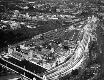
Examining the realpolitik of the approval process and the conflict over where Cudahy ought to locate its works provides insight into debates over industrial development in Los Angeles and other American cities.Footnote 42 From 1892 forward manufactories like the Cudahy works became more numerous and industry interspersed with residences, shops and offices adjacent to schools, public baths and other institutions had become the norm in the wards along the river (see Figure 4). Yet Board of Health reports and petitions to the council indicate that the concerns expressed in 1892, and the problems alleged after, remained present and pressing. Public health documents and the statements of the health officer reveal that not all was right at the packinghouses.Footnote 43 Residents who shared space with Cudahy, Wilson, Ogden and Swift viewed meatpackers as an ongoing and expanding incursion in their neighbourhood. When Cudahy sought to rebuild its plant following a devastating fire in 1904 residents who argued against this could do so with evidence drawn from twelve years’ experience. Twenty-two property owners and tenants residing along Macy, Clara and Lyons streets pressed the council for an ordinance prohibiting the ‘erection or rebuilding of a slaughter house in. . .the vicinity of Macy Street near the river’. The petitioners stated their case as dispassionately as one could given that the ‘slaughter house that recently existed in said district was for many years tolerated as an existing evil in the nature of a “vested right”‘. Note that the petitioners called the works a ‘slaughter house’ rather than a ‘packinghouse’ the term proponents used when they talked about science and downplayed the slaughter.
Oblique aerial view of the Cudahy Packing Company looking to the north and west. This image documents the north end of the East Side Industrial District with its mix of land uses and interdigitation of production with transportation, warehouses, commerce and residences. Note the rail lines along the river bluff and on Alameda Street (Southern Pacific), the plant of Wilson & Co. in the middle ground and the saw-tooth roofs of Llewellyn Iron Works in the distance.

Residents who sought to restrict industry asked the council to consider relocating meatpacking to ‘vacant land in suitable situations’ available for just such a use. They were, in effect, thinking on a metropolitan or regional scale. Why commit a ‘crime’ and ‘pollute the city with a slaughter house’? More specifically, why continue to jeopardize the health and wellbeing of those adjacent to the works, notably a ‘large public school where about five hundred children are in attendance’? The ‘thing “smells to heaven”. . .is a constant source of annoyance [with] the squealing and bellowing of animals being slaughtered, the noxious, offensive and poisonous odors that emanate from all such places. . .it is a complete and unmitigated nuisance’. They concluded with a simple plea for ‘justice. . .we will not be satisfied with anything else’.Footnote 44
Fifteen of their neighbours filed a petition asking the council to revoke the 1892 ordinance and to rescind Simon Maier's permit for the construction of a stockyard and slaughterhouse on 13 acres adjacent to Cudahy. That site, they noted, could be reached in a 10-minute walk from the Plaza, a location ‘close in. . .used very much by working men for homes enabling him to walk to his work’. (Recall the description of the district as a ‘residence outskirts of the city’ by those representing property owner T. Jeff White in 1892.) The slaughtering companies, on the other hand, had the means to acquire ‘as much of the Earth as they want outside of the city’ so why drive away ‘thousands to benefit a few rich men’? These ‘law-abiding citizens’ had suffered enough from the Cudahy plant. Why extend the territory of dying cattle and ‘disease-breeding stench’ in the ‘heart’ of the city? ‘You would not allow a slaughtering house in the west end among fashionable homes’ they declared. ‘Are not the homes of the poor as dear to them as the homes of the rich are to the rich?’ Of course they were since the ‘poor’ possessed less in material assets than the ‘rich’.Footnote 45
Conclusion
Cudahy rebuilt on the same site. Space, alliances and regulation are fundamental factors when analysing why. In terms of space, understanding what ‘east’ meant and its function as an antipode to the ‘west end’ of ‘fashionable homes’ is essential. When the padres and pobladores walked the pueblo boundaries on 4 September 1781 they circumambulated private lots in the pueblo proper and marked these as distinct from common land to the east. When residents relocated the Plaza to higher ground in 1818 it reinforced a distinction between high (Plaza) and low (river) ground. Beginning in the Mexican era, nuisance land uses, whether the ‘Indian village’, the dog pound or illicit activities were shunted east, along either side of the river.Footnote 46 The river has played a double role in the Californio and Angeleno imaginary. It was a primary determinant when Governor de Neve chose a pueblo site and it continued to be the principal water source for the first half-century of the American era. Yet all the while residents used the river as a conduit to dispose of waste and redistribute waste away from residences and businesses to the edge of urban development.
From the 1860s onward the zone east of the Plaza held a unique place in the imaginary geography of Anglo residents as the site for illicit sex and gambling (Calle de los Negroes), as the mysterious warrens of the ‘heathen Chinee’ (Chinatown) and as Sonoratown. This zone, sandwiched between the emergent well-to-do west side and the upright if working-class East Los Angeles and Boyle Heights, developed as a mixed-use, mixed-race, mixed-class and therefore marginal zone, a seemingly ‘natural’ site for manufacturing. A 1929 editorial in the Huntington Park Daily Signal presented this divide as if it were a fact of nature. ‘Thousands would not be able to enjoy the beaches, the mountains, and other peerless advantages which [southern] California offers to its residents were it not for industries which make it possible for them to gain a livelihood. Back of the beautiful residential development of the county's west side is the industry of the east side.’Footnote 47
The significance of alliances and regulations is evident in the city's efforts to facilitate economic development, to attract investment and to expand employment through industrialization. Municipal officials offered enterprisers access to public resources, direct subsidies, below market leases, expedited approval of projects, or some combination of these incentives. This was true for Cudahy and for firms in sectors such as mineral refining, the production of jars and cans and chemicals. Advocates promoted meatpacking as an economic stimulus, they sought to encourage enterprisers, to capitalize on local resources, to employ current (and new) residents and to reduce costs for other producers in the region (who otherwise were at the mercy of remote suppliers and captive to railroad freight rates). However, often the benefits of such development accrued principally to financiers and those directly employed by firms while those who resided near production facilities paid a price for the common good. Assessing past benefits and costs as well as long-term effects is a subject for further study. For this article the central finding has been that municipal stimulus and incentives were critical for the creation of industrial Los Angeles. Understanding land use, resource allocation, the politics of public works and related activities is essential when interpreting past growth, current conditions and future prospects in the city and region.
Understanding how and why Angelenos partitioned space at the turn of the twentieth century is as significant for understanding the present city as are better-known histories of an American Mediterranean, perhaps more so. This is true as well for theories of a world city and of postmodern urbanism, abstractions that tend to obscure the object of study. Rather than being assumed, the creation of a ‘modern, up-to-date metropolis’ in southern California ought to be examined. Micro-histories of urban development that account for industry, political alliances and the social production of location provide one means for doing so.Footnote 48