

Introduction
Many studies on the phytogeography of the Brazilian Atlantic Forest have focused on physiognomic and climatic features (Campos, Reference Campos1926; Santos, Reference Santos1943; Rizzini, Reference Rizzini1979; Veloso et al., Reference Veloso, Rangel Filho and Lima1991), and it is only more recently, with advances in taxonomic knowledge, that floristic correlations have also been included (Oliveira-Filho et al., Reference Oliveira-Filho, Vilela, Gavilanes and Carvalho1994, Reference Oliveira-Filho, Jarenkow, Rodal, Pennington, Ratter and Lewis2006; Torres et al., Reference Torres, Martins and Kinoshita1997; Ivanauskas et al., Reference Ivanauskas, Monteiro and Rodrigues2000; Oliveira-Filho & Fontes, Reference Oliveira-Filho and Fontes2000; Santos et al., Reference Santos, Silva and Tabarelli2007; Kamino et al., Reference Kamino, Oliveira-Filho and Stehmann2008).
Oliveira-Filho & Fontes (Reference Oliveira-Filho and Fontes2000) analysed the floristic composition of 125 forest areas in southeastern Brazil and correlated them to environmental factors. They demonstrated a marked floristic affinity between the rain forest and semideciduous and mixed forests, which many authors (Campos, Reference Campos1926; Santos, Reference Santos1943; Rizzini, Reference Rizzini1979; Leitão-Filho, Reference Leitão-Filho1987; Veloso et al., Reference Veloso, Rangel Filho and Lima1991) had considered as distinct formations, influenced by physiognomic and climatic features. Based on the marked floristic similarities, Oliveira-Filho & Fontes (Reference Oliveira-Filho and Fontes2000) proposed the recognition of the Atlantic Forest domain, encompassing all the forest physiognomies of eastern Brazil. Also, in a study of the phytogeographic patterns of eastern Brazilian river basins, Oliveira-Filho et al. (Reference Oliveira-Filho, Tameirão-Neto, Carvalho, Werneck, Brina and Vidal2005) concluded that floristic differences between rain and semideciduous forests are dictated mainly by the length of the dry season and the average annual rainfall, although both factors show a continuous latitudinal variation.
A number of studies (Salis et al., Reference Salis, Shepherd and Joly1995; Torres et al., Reference Torres, Martins and Kinoshita1997; Ivanauskas et al., Reference Ivanauskas, Monteiro and Rodrigues2000) have emphasised the influence of annual rainfall pattern, as well as altitude, on floristic similarity between areas of the Atlantic Forest in São Paulo State. Scudeller et al. (2001) commented on the pronounced floristic disparities between rainforest areas of such Atlantic Forest. Other studies on the floristic relationships between semideciduous forest areas in the Alto Rio Grande basin (Minas Gerais State) have shown that geographic proximity and altitude exert an influence on similarity patterns, together with other variables such as available water and soil characteristics (Oliveira-Filho et al., Reference Oliveira-Filho, Vilela, Gavilanes and Carvalho1994; Van den Berg & Oliveira-Filho, Reference Van den Berg and Oliveira-Filho2000; Gonzaga et al., Reference Gonzaga, Oliveira-Filho, Machado, Hargreaves and Machado2008).
Studies by Kamino et al. (Reference Kamino, Oliveira-Filho and Stehmann2008) on 18 forest areas extending along the Espinhaço Range, one of the western limits of the Atlantic Forest, demonstrated four arboreal floristic groups that correlated with geographic and climatic variables: the ‘Quadrilátero Ferrífero’, comprising those sites found in the Quadrilátero Ferrífero; the ‘Chapada de São Domingos’, for the sites in the eastern Septentrional Espinhaço; the ‘Espinhaço Central’, for the sites in the central part of the Espinhaço Range; and the ‘Septentrional Disjunctions of the Chapada Diamantina’, comprising the sites in the northern Chapada Diamantina (see geomorphological description of the Espinhaço Range below).
In the present study we used floristic surveys to evaluate phytogeographic patterns in the Atlantic Semideciduous Forests in southeastern Brazil, particularly in the areas of the eastern river basins (sensu Oliveira-Filho et al., Reference Oliveira-Filho, Tameirão-Neto, Carvalho, Werneck, Brina and Vidal2005), the Alto Rio Grande basin, and the Espinhaço Range. We aimed to (i) analyse the phytogeographic patterns in these areas as related to the Atlantic Forest domain, (ii) analyse in detail the phytogeographic patterns of forest areas in the Espinhaço Range, (iii) identify species that show congruent distributions with the phytogeographic patterns, and (iv) look for possible environmental factors that exert an influence on the patterns observed.
Study Areas and Methodology
Atlantic Forest
The Atlantic Forest sensu lato includes rain forest (Atlantic Forest sensu stricto) as well as mixed, semideciduous and deciduous forests (Joly et al., Reference Joly, Aidar, Klink, McGrath, Moreira and Moutinho1999; Oliveira-Filho & Fontes, Reference Oliveira-Filho and Fontes2000). It originally extended over some 3300 km of the eastern part of South America, between latitudes 6° and 30°S, and up to 700 km inland, covering a total area of 1.1 million km2 (Fernandes & Bezerra, Reference Fernandes and Bezerra1990; SOS Mata Atlântica & INPE, 1993; Oliveira-Filho & Fontes, Reference Oliveira-Filho and Fontes2000).
In the Atlantic Forest, the rain forests occur in areas where the dry season lasts for 30 days or less. This comprises mainly the coastal areas up to 50–300 km inland. The semideciduous forests occur where the dry season lasts for 40–160 days, occupying areas up to 700 km inland. The transitions between these two contiguous forest types are very complex and may be gradual or abrupt (Oliveira-Filho & Fontes, Reference Oliveira-Filho and Fontes2000).
Espinhaço Range
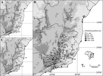
The Espinhaço Range extends for c.1200 km north–south from the central region of Minas Gerais to the northern limit of Bahia (Almeida-Abreu & Renger, Reference Almeida-Abreu and Renger2002) (Fig. 1A). It is divided into Septentrional and Meridional zones, and the region called ‘Chapada Diamantina’. Each of these regions differs in geological and geomorphological aspects (Pedreira, Reference Pedreira1994; Almeida-Abreu, Reference Almeida-Abreu1995; Saadi, Reference Saadi1995; Almeida-Abreu & Renger, Reference Almeida-Abreu and Renger2002). Overall the present geomorphological constitution of the Espinhaço Range is best termed a plateau (Saadi, Reference Saadi1995), and is the result of tectonic, glacial and erosive processes since the Mesoproterozoic Age (Saadi, Reference Saadi1995; Almeida-Abreu & Renger, Reference Almeida-Abreu and Renger2002). The main geological formation of the Espinhaço Range is the Espinhaço Supergroup, formed mostly by quartzitic lithologies (Almeida-Abreu, Reference Almeida-Abreu1995; Saadi, Reference Saadi1995). In the shallow and oligotrophic quartzite soils the typical xeromorphic vegetation of the Espinhaço, called the campo rupestre, occurs. This vegetation is dominated by certain families, such as Eriocaulaceae, Velloziaceae and Xyridaceae (Giulietti et al., Reference Giulietti, Menezes, Pirani, Meguro and Wanderley1987, Reference Giulietti, Pirani, Harley, Davis, Heywood, Herrera-MacBryde, Villa-Lobos and Hamilton1997). However, in places where other lithologies predominate, a deep mesotrophic soil can be formed, thus permitting the establishment of extensive, tall forests (Almeida-Abreu et al., Reference Almeida-Abreu, Fraga, Neves, Silva, Pedreira and Almeida-Abreu2005).
(A) Geomorphological areas and Brazilian states cited in the text. Legend: Solid line delineates states (BA = Bahia, ES = Espírito Santo, MG = Minas Gerais, RJ = Rio de Janeiro, SP = São Paulo). Dashed line delineates the Espinhaço Supergroup. Dotted line delineates the Quadrilátero Ferrífero. Dashed line ± parallel to coast = extension of the Serra do Mar. Solid line ± parallel to coast = extension of the Serra da Mantiqueira. (B) Sites of the 54 surveys of arboreal species in the Atlantic Forest. Localities are cited according to the codes in Table 1. The surveys at Linhares and Viçosa are represented by only one symbol. Legend: ▪ = Alto Rio Grande basin, □ = Rio das Contas basin, ▴ = Rio Doce basin, ▽ = Rio Itanhém basin, △ = Rio Itapemirim basin, • = Rio Jequitinhonha basin, ○ = Rio Paraguaçu basin, ♦ = Rio Paraíba do Sul basin, ▾ = Rio São Francisco basin. (C) River basin boundaries: I = Alto Rio Grande, II = Rio das Contas, III = Rio Doce, IV = Rio Itanhém, V = Rio Itapemirim, VI = Rio Jequitinhonha, VII = Rio Paraguaçu, VIII = Rio Paraíba do Sul, IX = Rio São Francisco.

The Quadrilátero Ferrífero is an iron-ore rich area contiguous with the south of the Espinhaço Range, comprising a roughly quadrangular arrangement of synclines with outcropping sedimentary platforms of the Minas Supergroup (Palaeoproterozoic Age), that are separated by Archean and Proterozoic geological formations (Rosière & Chemale Jr., Reference Rosière and Chemale2000). Gontijo (Reference Gontijo2008) included the ‘Quadrilátero Ferrífero’ formation as part of a more ample definition of the term Espinhaço Range. Here we consider the Espinhaço Range and the ‘Quadrilátero Ferrífero’ as distinct formations, due to the differences in their age and lithology (see Almeida-Abreu, Reference Almeida-Abreu1995; Saadi, Reference Saadi1995; Rosière & Chemale Jr., Reference Rosière and Chemale2000; Almeida-Abreu & Renger, Reference Almeida-Abreu and Renger2002). The Quadrilátero Ferrífero was included in this study due to its proximity to the Espinhaço, with the two formations constituting a continuous assemblage of elevations (Fig. 1A).
Data analysis
Data from 54 published arboreal floristic surveys in the Atlantic Forest sensu lato in southeastern Brazil and in the Espinhaço Range were selected for analysis (Fig. 1B; Table 1). These included five surveys in Atlantic Rain Forests and 49 in areas of Atlantic Semideciduous Forests, of which 10 were in the Espinhaço Range and seven in the Quadrilátero Ferrífero. To permit better visualisation of the results, the survey sites were classified according to their river basin: 20 in the Rio Doce basin, 12 in the Alto Rio Grande basin, 7 in the Rio Jequitinhonha basin, 5 in the Rio São Francisco basin, 5 in the Rio Paraíba do Sul basin, 2 in the Rio Paraguaçu basin, and 1 in each of the Rio das Contas, Rio Itanhém and Rio Itapemirim basins (Fig. 1B & C).
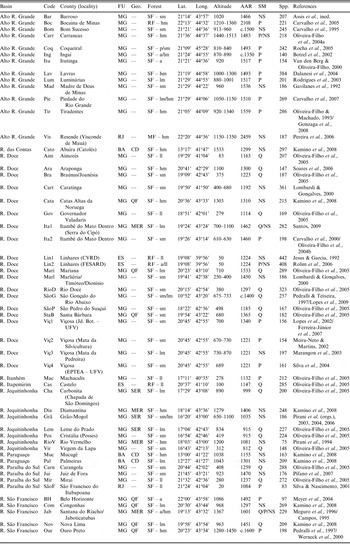
The 54 survey sites of arboreal species in the Atlantic Forest, with geographic, environmental and methodological information. The areas are listed alphabetically by basin and then by code

FU = Federal Unit; Geo. = geomorphology; Lat. = latitude; Long. = longitude; AAR = average annual rainfall; SM = sampling methodology; Spp. = number of species; R. = River; QF = Quadrilátero Ferrífero; MER = Meridional Espinhaço Range; SER = Septentrional Espinhaço Range; CD = Chapada Diamantina; SF = semideciduous forest; RF = rain forest; MF = mixed forest; p = paludal; a = alluvial; ll = lowlands; sm = sub-montane; lm = low-mountain; hm = high-mountain; Q = quadrat; P = parcel; NS = non-systematic. There is space in the column ‘Geomorphology’ only for localities pertaining to the Espinhaço Range and the Quadrilátero Ferrífero.
The published floristic lists chosen for our analysis were produced by a variety of survey methods, including quadrats, point-centre quarter method, and general collecting (‘non-systematic’). For surveys that included herbs, lianas, etc., only those species cited as arboreal by Oliveira-Filho (Reference Oliveira-Filho2006) were included. When species identification was uncertain (i.e. determined as ‘cf.’ or ‘aff.’) we included such taxa as belonging to the species referred to. Only lists with more than 90% of identified species were included.
Table 1 contains geographical coordinates and other information about the floristic survey for each locality, together with the codes by which they are cited in the figures. The data were compiled from the published floristic surveys, with the database ‘TreeAtlan 2.0’ (Oliveira-Filho, Reference Oliveira-Filho2010) being used for missing data.
Two forms of multivariate analysis, one for clustering and the other for correspondence, were applied whereby the species registered in each of the 54 sites were first allotted to a presence and absence matrix. To facilitate the analysis, species present in only one area were then excluded (Ratter et al., Reference Ratter, Bridgewater and Ribeiro2003). A dendrogram was constructed using UPGMA (Unweighted Pair Group with Arithmetic Mean) for grouping, the simplest and most widely used method for this type of analysis (Pielou, Reference Pielou1984). Both Jaccard and Sørensen similarity indices, adjusted for binary data, were then applied, although only the former are reported since both indicated a similar pattern between areas. Detrended Correspondence Analysis (DCA) was applied to compare the patterns revealed, to determine to what extent the various analyses would result in congruent patterns. Detrended Correspondence Analysis is appropriate for such studies involving heterogenic and complex samples that reveal little change in a continuous gradient (Gauch, Reference Gauch1982; Pielou, Reference Pielou1984). The Multivariate Statistical Package (MVSP) program (Kovach, Reference Kovach2004) was used for the UPGMA and DCA analyses. The patterns generated by the analyses were considered as indirect measurements of modulating environmental factors (Gauch, Reference Gauch1982). Since the selected surveys are not suitable for making conclusions about geographic distributions, as they are too limited, the discussion on species distributions was supplemented with data from recent literature.
Jaccard similarity indices were applied to the Espinhaço and Quadrilátero Ferrífero sites to better understand phytogeographic relationships between them. Furthermore, in the group formed exclusively by forest areas inside the campos rupestres of Espinhaço in the cluster (group 1) and correspondence analyses, those species with more than 50% occurrence were indicated, in order to distinguish typical species and emphasise vegetation features.
Results
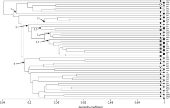
The cluster analysis (UPGMA) produced four main groups (Fig. 2):
• Group 1 includes forests located throughout the entire Espinhaço Range, i.e. in the Meridional (Diamantina, Santana do Riacho/Jaboticatubas, Rio Vermelho) and Septentrional (Grão-Mogol) zones, as well as in the southern Chapada Diamantina (Palmeiras, Mucugê, Catolés). Other areas in the Espinhaço were not included in this group (see below).
• Group 2 includes forest areas in the Rio Jequitinhonha basin. Chapada de São Domingos and Leme do Prado, located in the Septentrional Espinhaço, are part of this group. Note that although the Diamantina, Serra do Ambrósio and Grão-Mogol sites are situated at the upper drainage of this basin, their affinity is rather with group 1.
• Group 3 includes three distinct subgroups, one (3.1) predominantly of forest areas of the Alto Rio Grande basin; another (3.2) of upland forests (altitude > 1100 m, sensu Oliveira-Filho & Fontes, Reference Oliveira-Filho and Fontes2000) occurring in the Quadrilátero Ferrífero, at Catas Altas da Noruega, Congonhas, Mariana and Nova Lima (note that Ouro Preto and Belo Horizonte, also situated in the Quadrilátero Ferrífero, are isolated from this group); and a third subgroup (3.3) comprising upland forests of the Serra da Mantiqueira (Visconde de Mauá, Carrancas, Bocaina de Minas).
• Group 4 includes forest areas in the Rio Paraíba do Sul (Juiz de Fora, Carangola, Miraí) and Rio Doce basins, as well as one in the Rio Itanhém basin and one in the Rio Itapemirim basin. Itambé do Mato Dentro (located in the Meridional Espinhaço) and Santa Bárbara (located in the Quadrilátero Ferrífero) are also in this group.
UPGMA dendrogram, based on the Jaccard index, comparing 54 surveys of arboreal species in the Atlantic Forest. Localities are cited according to the codes in Table 1. The symbols on the terminal branches correspond to the basin to which surveyed areas pertain. Groups discussed in the text are highlighted. Localities in the Quadrilátero Ferrífero and Espinhaço Range are marked with an asterisk (*). Legend: ▪ = Alto Rio Grande basin, □ = Rio das Contas basin, ▴ = Rio Doce basin, ▽ = Rio Itanhém basin, △ = Rio Itapemirim basin, • = Rio Jequitinhonha basin, ○ = Rio Paraguaçu Basin, ♦ = Rio Paraíba do Sul basin, ▾ = Rio São Francisco basin.

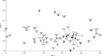
In the correspondence analysis, axes 1 and 2 resolved only 11% of the variation (7.3% and 3.8%, respectively). According to Ter Braak (Reference Ter Braak, Jongman, Ter Braak and van Tongeren1995), such low percentages are intermediary, thereby indicating moderate gradients, with some of the species distributed at all sites, while others are exclusive to certain sites (Fig. 3).
Graph of Detrended Correspondence Analysis (DCA), comparing 54 surveys of arboreal species in the Atlantic Forest. Localities are cited according to the codes in Table 1. Localities in the Quadrilátero Ferrífero and the Espinhaço Range are marked with an asterisk (*). Legend: ▪ = Alto Rio Grande basin, □ = Rio das Contas basin, ▴ = Rio Doce basin, ▽ = Rio Itanhém basin, △ = Rio Itapemirim basin, • = Rio Jequitinhonha basin, ○ = Rio Paraguaçu basin, ♦ = Rio Paraíba do Sul basin, ▾ = Rio São Francisco basin.

The patterns revealed in this analysis are partially congruent with results from the cluster analysis. Areas of the Espinhaço located in group 1 in the cluster analysis are at the extreme right of the DCA graph, but with considerable variation as determined by axis 2. Such variation may be related to latitude, since the more southern areas are placed in the lower part (except for Grão-Mogol). The influence of latitude can also be inferred for those areas in the Jequitinhonha basin (group 2 in the cluster analysis) that are located at higher latitudes, and present higher values with regard to axis 2. Although presenting high variation in relation to axis 1, this group is well differentiated by axis 2.
Another grouping similar to that revealed by cluster analysis, and linked mainly to axis 1, comprises the forest areas of the Rio Grande basin (located to the right of the figure), close to some areas of the Quadrilátero Ferrífero (Catas Altas da Noruega, Congonhas, Nova Lima and Ouro Preto) and all areas of the Serra da Mantiqueira (group 3 in the cluster analysis). Forest areas in basins that irrigate eastern Minas Gerais State (group 4 in the cluster analysis), on the other hand, are concentrated to the left of the figure, and show marked variation on axis 2. At the intersection of these two groups are the areas of Santa Bárbara, São Gonçalo do Rio Abaixo and Mariana, in the Rio Doce basin, and Belo Horizonte, in the Rio São Francisco basin (all of them included in the Quadrilátero Ferrífero except São Gonçalo), and Coqueiral and Piedade do Rio Grande, in the Alto Rio Grande basin. Subgroups 3.1, 3.2 and 3.3 were not discernible in the correspondence analysis.
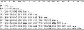
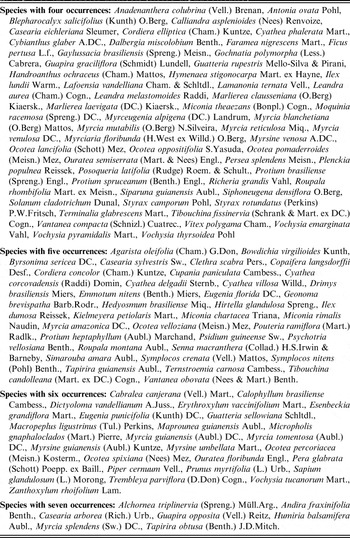
The Jaccard similarity index values for sites in the Espinhaço Range and Quadrilátero Ferrífero (Table 2) were mostly less than 25% (i.e. low sensu Mueller-Dombois & Ellenberg, Reference Mueller-Dombois and Ellenberg1974). Consequently, there was no general similarity among surveys, although there were small subgroups, some of which were revealed through multivariate analysis. The greatest similarities are indicated in bold type in Table 2. Those species with more than 50% occurrence in the group formed exclusively by forest areas inside the campos rupestres of Espinhaço, delimited by cluster (group 1) and correspondence analysis, are indicated in Table 3.
Similarity index (Jaccard) between localities in the Espinhaço Range and the Quadrilátero Ferrífero. Similarities > 25% are outstanding. For explanation of locality codes see Table 1

Species with more than 50% occurrence in the seven localities in group 1 of the cluster analysis (listed alphabetically)

Discussion
Phytogeographic patterns in the Atlantic Semideciduous Forests
The relatively high congruence of the patterns arising from the two analyses (cluster and correspondence) gives us confidence in the strength of the data and allows us to generate hypotheses regarding potential causes.
The analysis separated the Alto Rio Grande basin forests, group 3.1, from those of the Rio Jequitinhonha basin (group 2), and those of the Rio Doce and Rio Paraíba do Sul basins (group 4) (Figs 2, 3). This floristic pattern probably reflects the level of humidity throughout the year in these basins, since humidity plays a fundamental role in phytogeographic patterns in the Atlantic Forest (Torres et al., Reference Torres, Martins and Kinoshita1997; Ivanauskas et al., Reference Ivanauskas, Monteiro and Rodrigues2000; Oliveira-Filho & Fontes, Reference Oliveira-Filho and Fontes2000; Oliveira-Filho et al., Reference Oliveira-Filho, Tameirão-Neto, Carvalho, Werneck, Brina and Vidal2005, Reference Oliveira-Filho, Jarenkow, Rodal, Pennington, Ratter and Lewis2006; Durigan et al., Reference Durigan, Bernacci, Franco, Arbocz, Metzger and Catharino2008).
The seasonal areas in the Paraíba do Sul and Rio Doce basins have higher rainfall than those in the Alto Rio Grande basin and other seasonal areas. In the Paraíba do Sul basin, the Serra da Mantiqueira (see Fig. 1A & C) presents a barrier to oceanic humidity, promoting orographic rain in the region. In the Rio Doce basin, most of the humidity is due to the lowlands at the river-mouth (see Fig. 1C) which permit the penetration of oceanic moisture deeply into the continental interior, resulting in a gradual transition to a seasonal climate, and a less severe dry season (Campos, Reference Campos1926; Oliveira-Filho & Fontes, Reference Oliveira-Filho and Fontes2000; Oliveira-Filho et al., Reference Oliveira-Filho, Tameirão-Neto, Carvalho, Werneck, Brina and Vidal2005).
The relatively high humidity throughout the year permits the occurrence inland of species that are intolerant to higher seasonality. In areas where climatic seasonality is more pronounced (e.g. Alto Rio Grande and the Atlantic Plateau in São Paulo State) there is a greater contrast in floristic composition between wet and aseasonal and contiguous seasonal areas, due to the more abrupt change in climate (Torres et al., Reference Torres, Martins and Kinoshita1997; Ivanauskas et al., Reference Ivanauskas, Monteiro and Rodrigues2000; Oliveira-Filho & Fontes, Reference Oliveira-Filho and Fontes2000; Oliveira-Filho et al., Reference Oliveira-Filho, Tameirão-Neto, Carvalho, Werneck, Brina and Vidal2005; Durigan et al., Reference Durigan, Bernacci, Franco, Arbocz, Metzger and Catharino2008). This increased humidity allows some species to occur both in the semideciduous forests of the Doce and Paraíba do Sul river basins and in rain forests (see data in Oliveira-Filho et al., Reference Oliveira-Filho, Jarenkow, Rodal, Pennington, Ratter and Lewis2006 for the eastern part of the Atlantic Forest). Rolim et al. (Reference Rolim, Ivanauskas, Rodrigues, Nascimento, Gomes, Folli and Couto2006) claimed that there is more floristic affinity between rain forest of coastal areas of Espírito Santo State and contiguous inland semideciduous forests than between the former and rain forest further to the south. A number of species illustrate this pattern. One example is Tetrastylidium grandifolium (Baill.) Sleumer (Olacaceae), which occurs in rain forests from the south of São Paulo State to the south of Bahia and only in semideciduous forests of the Paraíba do Sul and Rio Doce basins (Sleumer, Reference Sleumer1984; Oliveira-Filho, Reference Oliveira-Filho2006). Other species show a similar pattern (by family):
• Annonaceae: Trigynaea oblongifolia Schltdl. (Maas et al., Reference Maas, Kamer, Junikka, Mello-Silva and Rainer2001; Oliveira-Filho, Reference Oliveira-Filho2006);
• Arecaceae: Polyandrococos caudescens (Mart.) Barb.Rodr. (Henderson et al., Reference Henderson, Galeano and Bernal1995; Oliveira-Filho, Reference Oliveira-Filho2006);
• Bignoniaceae: Paratecoma peroba (Record) Kuhlm. (Gentry, Reference Gentry1992);
• Burseraceae: Crepidospermum atlanticum Daly (Daly, Reference Daly2002; Oliveira-Filho, Reference Oliveira-Filho2006);
• Celastraceae: Maytenus brasiliensis Mart. (Joffily & Vieira, Reference Joffily and Vieira2006; Oliveira-Filho, Reference Oliveira-Filho2006);
• Chrysobalanaceae: Licania belemii Prance (Prance, Reference Prance1989; Oliveira-Filho, Reference Oliveira-Filho2006);
• Clusiaceae: Tovomita leucantha (Schltdl.) Planch. & Triana (Oliveira-Filho, Reference Oliveira-Filho2006);
• Lauraceae: Nectandra leucantha Nees (Rohwer, Reference Rohwer1993), Nectandra psammophila Nees (Rohwer, Reference Rohwer1993), Ocotea beyrichii (Nees) Mez (Baitello et al., Reference Baitello, Hernandez, Moraes, Esteves, Marcovino, Wanderley, Shepherd, Giulietti and Melhem2003; Oliveira-Filho, Reference Oliveira-Filho2006), Urbanodendron verrucosum (Nees) Mez (Rohwer, Reference Rohwer1988);
• Malvaceae: Eriotheca macrophylla (K.Schum.) A.Robyns (Oliveira-Filho, Reference Oliveira-Filho2006);
• Melastomataceae: Miconia budlejoides Triana (Oliveira-Filho, Reference Oliveira-Filho2006);
• Moraceae: Helicostylis tomentosa (Poepp. & Endl.) Rusby (Berg, Reference Berg1972; Oliveira-Filho, Reference Oliveira-Filho2006);
• Myrtaceae: Campomanesia laurifolia Gardner (Landrum, Reference Landrum1986; Oliveira-Filho, Reference Oliveira-Filho2006), Myrcia anceps (Spreng.) O.Berg (Oliveira-Filho, Reference Oliveira-Filho2006);
• Rubiaceae: Rudgea reticulata Benth. (Zappi, Reference Zappi2003);
• Rutaceae: Pilocarpus giganteus Engl. (Skorupa, Reference Skorupa1996);
• Salicaceae: Banara kuhlmannii (Sleumer) Sleumer (Sleumer, Reference Sleumer1980);
• Sapotaceae: Chrysophyllum imperiale (Linden ex Koch & Fintelm.) Benth. & Hook.f., Pouteria microstrigosa T.D.Penn. (Pennington, Reference Pennington1990).
The distribution of some species also extends to seasonal areas in the Itanhém and Jequitinhonha river basins, which have a similar relief (see Fig. 1C), and thus similar rainfall, to that of the Rio Doce basin. Examples include (by family):
• Achariaceae: Carpotroche brasiliensis (Raddi) Endl. (Sleumer, Reference Sleumer1980; Oliveira-Filho, Reference Oliveira-Filho2006);
• Anacardiaceae: Thyrsodium spruceanum Salzm. ex Benth. (Mitchell & Daly, Reference Mitchell and Daly1993; Oliveira-Filho, Reference Oliveira-Filho2006);
• Annonaceae: Bocagea longipedunculata Mart., Duguetia chrysocarpa Maas (Maas et al., Reference Maas, Kamer, Junikka, Mello-Silva and Rainer2001; Oliveira-Filho, Reference Oliveira-Filho2006);
• Arecaceae: Astrocaryum aculeatissimum (Schott) Burret (Henderson et al., Reference Henderson, Galeano and Bernal1995; Oliveira-Filho, Reference Oliveira-Filho2006);
• Combretaceae: Buchenavia hoehneana N.F.Mattos (Oliveira-Filho, Reference Oliveira-Filho2010);
• Euphorbiaceae: Joannesia princeps Vell., Senefeldera verticillata (Vell.) Croizat (Oliveira-Filho, Reference Oliveira-Filho2006);
• Malvaceae: Sterculia curiosa (Vell.) Taroda (Oliveira-Filho, Reference Oliveira-Filho2010);
• Rubiaceae: Genipa infundibuliformis Zappi & Semir (Zappi et al., Reference Zappi, Semir and Pierozzi1995; Oliveira-Filho, Reference Oliveira-Filho2006).
This higher rainfall also accounts for the similarity in floristic composition at Machacalis (Rio Itanhém basin) and Aimorés and Governador Valadares (Rio Doce basin). However, the climate in the more interior of these basins is influenced by the Atlantic Equatorial air mass (hot and dry) during a large part of the year, giving a marked seasonality. Thus, the penetration of humidity towards the continental interior is limited, and the relatively high humidity, as seen in Machacalis, occurs only in the more easterly areas of the basins.
This climate pattern probably exerts an influence on the group formed by areas in the Jequitinhonha basin, all of which lie towards the interior of the basin (group 2 in the cluster analysis). Arboreal species that are typical of the dry climate of the Caatinga domain occur at these sites. Amongst these are (by family):
• Anacardiaceae: Cyrtocarpa caatingae J.D.Mitch. & Daly (Oliveira-Filho, Reference Oliveira-Filho2006);
• Burseraceae: Commiphora leptophloeos (Mart.) J.B.Gillet (Gillet, Reference Gillet1980; Oliveira-Filho, Reference Oliveira-Filho2006);
• Cactaceae: Cereus jamacaru DC. (Oliveira-Filho, Reference Oliveira-Filho2006);
• Leguminosae–Mimosoideae: Acacia spp., Blanchetiodendron blanchetii (Benth.) Barneby & J.W.Grimes (Queiroz, Reference Queiroz2009);
• Rhamnaceae:Ziziphus joazeiro Mart. (Lima, Reference Lima2000).
The seasonal areas of Alto Rio Grande, which are situated on the opposite slope of the Serra da Mantiqueira, have lower rainfall mainly because Atlantic humidity is impeded by the Serra do Mar scarps, as well as by the Serra da Mantiqueira itself (see Fig. 1A & C). Even so, seasonal areas in the Alto Rio Grande have some floristic similarities with the adjacent higher rainfall areas situated on top of the Serra da Mantiqueira, as can be seen in group 3 (subgroups 3.1 and 3.3) in the UPGMA analysis. However, moving westwards, there is a rapid increase in seasonality, reflected in the transition from the Atlantic Forest to the Cerrado domains which occurs throughout the mid-part of the basin (see maps of the IBGE, 1993; Oliveira-Filho, Reference Oliveira-Filho2006). Durigan et al. (Reference Durigan, Bernacci, Franco, Arbocz, Metzger and Catharino2008) encountered a similar pattern in their analysis of forest fragments on the Paulistano Plateau, part of the Atlantic Plateau located immediately to the interior of the Serra do Mar heights. They noted that the flora of the southern area (more humid and facing the ocean) shows a greater similarity with rain forests, whereas to the north (less humid and facing the interior) the similarity is with semideciduous forests and cerrado. Thus, even in neighbouring areas, the decrease in humidity related to relief exerts a marked influence on floristic composition.
The following are some common species of the Cerrado domain which occur in the semideciduous forests of the Alto Rio Grande basin but are rare or absent in forest areas of the Rio Paraíba do Sul and Rio Doce basins:
• Erythroxylaceae: Erythroxylum daphnites Mart. (Mendonça & Amaral Júnior, Reference Mendonça, Amaral Júnior, Wanderley, Shepherd, Giulietti and Melhem2002; Oliveira-Filho, Reference Oliveira-Filho2006);
• Lauraceae: Nectandra gardneri Meisn. (Rohwer, Reference Rohwer1993; Oliveira-Filho, Reference Oliveira-Filho2006);
• Leguminosae–Mimosoideae: Enterolobium gummiferum (Mart.) J.F.Macbr. (Oliveira-Filho, Reference Oliveira-Filho2006), Stryphnodendron adstringens (Mart.) Coville (Oliveira-Filho, Reference Oliveira-Filho2006; Scalon, Reference Scalon2007);
• Leguminosae–Papilionoideae: Dalbergia miscolobium Benth. (Carvalho, Reference Carvalho1997; Oliveira-Filho, Reference Oliveira-Filho2006), Holocalyx balansae Micheli (Oliveira-Filho, Reference Oliveira-Filho2006);
• Malvaceae: Luehea paniculata Mart. & Zucc. (Oliveira-Filho, Reference Oliveira-Filho2006), Pseudobombax longiflorum (Mart. & Zucc.) A.Robyns (Oliveira-Filho, Reference Oliveira-Filho2006; Duarte et al., Reference Duarte, Esteves, Semir, Wanderley, Shepherd, Giulietti and Melhem2007);
• Myrtaceae: Eugenia klotzschiana O.Berg (Oliveira-Filho, Reference Oliveira-Filho2006).
Several authors have noted the influence of altitude on floristic similarity between areas of the Atlantic Forest domain (Oliveira-Filho et al., Reference Oliveira-Filho, Vilela, Gavilanes and Carvalho1994; Torres et al., Reference Torres, Martins and Kinoshita1997; Ivanauskas et al., Reference Ivanauskas, Monteiro and Rodrigues2000). In the current study altitude was not found to be an important factor for similarity between the semideciduous forests; in general, most of the floristic similarities revealed (in both cluster and correspondence analyses) can be explained by the influence of relief on Atlantic humidity. Furthermore, montane areas, such as Araponga (1100 m) and Itambé do Mato Dentro (Serra do Cipó – 700–1100 m), are grouped together with lowland forest areas, such as Miraí, Rio Doce and Carangola, at 280, 380 and 408 m, respectively (Figs 2, 3; Table 1).
Moreover, according to Oliveira-Filho et al. (Reference Oliveira-Filho, Jarenkow, Rodal, Pennington, Ratter and Lewis2006), the floristic similarity of some montane areas (e.g. areas in the Alto Rio Grande, the Atlantic Plateau), supposedly associated with altitude, may be more linked to the proximity of these areas to the coast when compared with drier sub-montane areas further inland. The floristic differences between these montane and sub-montane areas may be more related to differences in seasonality than to altitude.
Nevertheless, it should be noted that our analysis revealed the influence of altitude on groups formed by the more upland areas of the Espinhaço Range, Serra da Mantiqueira and the Quadrilátero Ferrífero (Figs 2, 3; Table 1; see discussion below). In particular, the floristic similarity shown by areas of the Quadrilátero Ferrífero and the Meridional Espinhaço in the DCA and UPGMA analyses is of great interest, since it emphasises the fact that these areas of the Atlantic Forest form a continuum of semideciduous montane forests.
In contrast to some previous studies (Van den Berg & Oliveira-Filho, Reference Van den Berg and Oliveira-Filho2000; Gonzaga et al., Reference Gonzaga, Oliveira-Filho, Machado, Hargreaves and Machado2008), in our analysis geographical proximity exerted less influence on floristic similarity between areas. Some areas which showed floristic similarity were geographically far apart; these included some in different water basins, such as Aimorés and Governador Valadares in the Rio Doce basin and Machacalis in the Rio Itanhém basin. However, in many cases, geographical proximity does involve similarity in several environmental variables which results in a similar flora, as is shown by the grouping of areas in the Viçosa area (Fig. 2).
Nevertheless, it should be remembered that the factors we have considered are only part of the explanation for the current floristic composition of the semideciduous forests in the Atlantic Forest. These explanations are based only on present-day aspects (i.e. climate and species distribution), and historical factors (e.g. involving the biogeography of taxa, as well as climatic fluctuation during the Pleistocene) may also have played a role.
Phytogeography of the forests of the Espinhaço Range
Forests throughout the Espinhaço Range are floristically very heterogeneous, reflecting the variety of climates, lithology, relief, soils and floristic domains found in this geological formation (Ab’Saber, Reference Ab’Saber1971; Giulietti & Pirani, Reference Giulietti, Pirani, Vanzolini and Heyer1988; Saadi, Reference Saadi1995; Almeida-Abreu & Renger, Reference Almeida-Abreu and Renger2002; Silva, Reference Silva, Silva, Pedreira and Almeida-Abreu2005). The floristic affinities of each forest area are not obvious because the forest structure and composition varies, even over small areas (Harley, Reference Harley and Stannard1995). In fact, over all the analyses, floristic dissimilarity was the rule, often strikingly so, in adjacent localities (Fig. 1B; Tables 1, 2).
The sites clustered in group 1 of the UPGMA analysis (Fig. 2), largely confirmed with the correspondence analysis (Fig. 3) and partially so with the Jaccard index (Table 2), correspond to the ‘Espinhaço Central’ of Kamino et al. (Reference Kamino, Oliveira-Filho and Stehmann2008). The UPGMA group 1 includes forest areas situated throughout the Espinhaço Range (Meridional and Septentrional Espinhaço and the Chapada Diamantina) independent of geographic proximity; for example, the high level of similarity in areas as far apart as Diamantina and Catolés (35.0%) is outstanding (Table 2). These are the typical forest communities of the Espinhaço Range, being found within the campos rupestre, the most typical vegetation of Espinhaço. The floristic and physiognomic affinity of these forests is analogous to the gallery forests and pockets of semideciduous forest in the Cerrado domain, i.e. they are restricted to areas with richer and deeper soil and show floristic affinity with similar forest domains, despite being isolated within herbaceous or savanna vegetation.
In spite of the difficulty in clearly discerning factors responsible for floristic similarity between each area, particularly as floristic lists were often the result of surveys in which phytophysiognomies were not clearly distinguished, it seems likely that the campo rupestre possesses a combination of habitat features that lead to the development of a distinct forest type. These are defined by the following:
• Factors linked to high altitude, such as an increase in humidity and a decrease in air temperature (Grubb, Reference Grubb1977). These factors can both limit and stimulate the establishment of certain species. Among those with more than 50% occurrence in the ‘Espinhaço Central’ group are the following typical upland species: Hedyosmum brasiliense Miq. (Chloranthaceae), Clethra scabra Pers. (Clethraceae), Erythroxylum vaccinifolium Mart. (Erythroxylaceae), Miconia chartacea Triana (Melastomataceae), Macropeplus ligustrinus (Tul.) Perkins (Monimiaceae) and Drimys brasiliensis Miers (Winteraceae) (see data for distributions in Giulietti & Pirani, Reference Giulietti, Pirani, Vanzolini and Heyer1988; Oliveira-Filho & Fontes, Reference Oliveira-Filho and Fontes2000; Santos & Peixoto, Reference Santos and Peixoto2001) (Table 3).
• Factors linked to the soil, which in the case of campo rupestre is shallow and nutrient-poor (Silva, Reference Silva, Silva, Pedreira and Almeida-Abreu2005), which limits the establishment of certain species. Furthermore, soil factors which limit forest expansion facilitate the penetration of light, thereby favouring the establishment of heliophytes to the detriment of shade-tolerant species (at least in some phenological stages). Thus, Tapirira obtusa (Benth.) J.D.Mitch. (Anacardiaceae), Alchornea triplinervia (Spreng.) Müll.Arg. (Euphorbiaceae), Pera glabrata (Schott) Poepp. ex Baill. (Euphorbiaceae), Cabralea canjerana (Vell.) Mart. (Meliaceae), Myrcia splendens (Sw.) DC. (Myrtaceae), Myrcia tomentosa (Aubl.) DC. (Myrtaceae) and Zanthoxylum rhoifolium Lam. (Rutaceae) are very common heliophyte species in these areas (Table 3).
Several authors have stated that the restricted and endemic distribution pattern in the campo rupestre applies mainly to herbaceous and shrub species, whereas many of the arboreal species are widely distributed throughout Brazilian forest domains (Giulietti et al., Reference Giulietti, Menezes, Pirani, Meguro and Wanderley1987; Giulietti & Pirani, Reference Giulietti, Pirani, Vanzolini and Heyer1988; Meguro et al., Reference Meguro, Pirani, Mello-Silva and Giulietti1996). The ‘Espinhaço Central’ group recognised in our analysis does indeed contain some species with a wide distribution. Examples of such taxa (with more than 50% occurrence) are: Tapirira guianensis Aubl. (Anacardiaceae), Alchornea triplinervia, Emmotum nitens (Benth.) Miers (Icacinaceae), Copaifera langsdorffii Desf. (Leguminosae), Andira fraxinifolia Benth. (Leguminosae), Bowdichia virgilioides Kunth (Leguminosae), Myrsine umbellata Mart. (Myrsinaceae), Guapira opposita (Vell.) Reitz (Nyctaginaceae), Roupala montana Aubl. (Proteaceae), Zanthoxylum rhoifolium and Vochysia tucanorum Mart. (Vochysiaceae).
With regard to arboreal species that are endemic to the Espinhaço Range, there are few records in the literature, and most are also distributed in the Quadrilátero Ferrífero. Among these are (by family):
• Annonaceae: Guatteria notabilis Mello-Silva & Pirani, endemic to forests of the Espinhaço Range, and Guatteria rupestris Mello-Silva & Pirani, endemic to forests of the Meridional and Septentrional parts of the Espinhaço Range (Mello-Silva & Pirani, Reference Mello-Silva and Pirani2003);
• Apocynaceae: Aspidosperma dispermum Müll.Arg., endemic to forest areas of the Meridional and Septentrional Espinhaço Range (Oliveira & Pirani, Reference Oliveira and Pirani2003);
• Asteraceae: Gochnatia hatschbachii Cabrera, endemic to the Serra do Cipó (Meridional Espinhaço Range), which, although it does occur in forests, is more common in open areas (Roque & Pirani, Reference Roque and Pirani1997);
• Ebenaceae: Diospyros ketun B.Walln., cited for forests of the Meridional and Septentrional Espinhaço Range and the Quadrilátero Ferrífero (Wallnöfer, Reference Wallnöfer1999; Santos & Sano, Reference Santos and Sano2004);
• Lauraceae: Nectandra venulosa Meisn. (Lauraceae), endemic to forests of the Meridional Espinhaço Range (Rohwer, Reference Rohwer1993; Oliveira-Filho, Reference Oliveira-Filho2006); Ocotea calliscypha L.C.S.Assis & Mello-Silva, cited for forests of the Meridional Espinhaço Range and the Quadrilátero Ferrífero (Assis & Mello-Silva, Reference Assis and Mello-Silva2009); Ocotea oppositifolia S.Yasuda, endemic to forests of the Espinhaço Range (Yasuda, Reference Yasuda1996; Assis et al., Reference Assis, Mello-Silva and Van der Werff2004);
• Malvaceae: Pseudobombax riopretense Ravenna, endemic to forest areas of the Meridional and Septentrional Espinhaço Range (Ravenna, Reference Ravenna2005; Oliveira-Filho, Reference Oliveira-Filho2006);
• Myrtaceae: Eugenia laruotteana Cambess., endemic to forests of the Meridional and Septentrional Espinhaço Range (Kawasaki, Reference Kawasaki2004); Myrciaria glanduliflora (Kiaersk.) Mattos & D.Legrand, endemic to forest areas and open country in the Meridional and Septentrional Espinhaço Range (Kawasaki, Reference Kawasaki1989, Reference Kawasaki2004; Sobral, Reference Sobral1993); Plinia espinhacensis Sobral, endemic to forests of the Meridional Espinhaço Range (Sobral, Reference Sobral2010);
• Proteaceae: Euplassa semicostata Plana, found in the cerrado and gallery forest in the Meridional Espinhaço Range and Quadrilátero Ferrífero (Plana & Prance, Reference Plana and Prance2004).
Because they are rare, these species do not account for the floristic similarities between areas of the Espinhaço; the similarities are usually due to more common taxa. However, these endemic forest species perhaps reflect a complex vegetational history of expansions and regressions of semideciduous woodlands in the Pleistocene (Ledru et al., Reference Ledru, Soares Braga, Soubiès, Fournier, Martin, Suguio and Turcq1996, Reference Ledru, Mourguiart and Riccomini2009; Behling, Reference Behling2002).
In addition to their ‘Espinhaço Central’ group, Kamino et al. (Reference Kamino, Oliveira-Filho and Stehmann2008) recognised other communities that are also reflected in the groups found in our analyses, although in all cases such groups are better understood within the context of a wider survey of the Atlantic Forest. For example, the similarity between Chapada de São Domingos and Leme do Prado (the sites that constitute the ‘Chapada de São Domingos’ group sensu Kamino et al., Reference Kamino, Oliveira-Filho and Stehmann2008) with two other areas (Posse and Virgem da Lapa), all of them in the Jequitinhonha basin, indicates that this group is more closely related to the vegetation in this river basin than to that of the Espinhaço forests.
The ‘Quadrilátero Ferrífero’ group (sensu Kamino et al., Reference Kamino, Oliveira-Filho and Stehmann2008) appears as a relatively robust group in our UPGMA analysis (group 3.2), although several localities included by Kamino et al. (Reference Kamino, Oliveira-Filho and Stehmann2008) (e.g. Belo Horizonte and Ouro Preto) were excluded from our grouping, as also was Santa Bárbara, which was grouped with areas in the Rio Doce and Rio Paraíba do Sul basins. Floristic affinity within the Quadrilátero Ferrífero group may be correlated with the upland character of its forests and geographical proximity. Although not clustered with group 3.2, Santa Bárbara showed high similarity (Jaccard index > 25%) with the Mariana and Nova Lima sites, thus providing some support for the floristic affinity among Quadrilátero Ferrífero areas. The sites at Belo Horizonte and Ouro Preto are very degraded areas and this could explain their low affinity with the others in the Quadrilátero Ferrífero. No species with restricted distributions occur in group 3.2, since the similarity was due to shared species with relatively wide distributions, such as Copaifera langsdorffii, Myrsine umbellata, Guapira opposita and Zanthoxylum rhoifolium. In both analyses (cluster and correspondence), this group also showed an affinity with areas in the Alto Rio Grande, although it is difficult to identify any particular factor influencing this pattern.
Finally, it is important to emphasise, as have other authors (Harley, Reference Harley and Stannard1995; Kamino et al., Reference Kamino, Oliveira-Filho and Stehmann2008), the need for further studies on forests throughout the Espinhaço Range, in particular because of the heterogeneity and large area of this formation. Moreover, a greater understanding of the regional geomorphology is necessary since much floristic variation is linked to this factor (Harley, Reference Harley and Stannard1995). Palaeontological studies that may shed light on the history of the forest vegetation of the area are also required.
Conclusion
• The prevailing relief in the basins of the Alto Rio Grande, Rio Jequitinhonha, Rio Doce, Rio Itanhém and Rio Paraíba do Sul has exerted an influence on rainfall and seasonality in these areas which, in turn, has exerted a major influence on the composition of their semideciduous forests.
• Geographic proximity and altitude, although important factors, played a secondary role in the phytogeographic patterns analysed.
• In spite of the pronounced floristic heterogeneity encountered throughout the forests of the Espinhaço Range, there is a physiognomic and floristic affinity among some areas, namely those within the campo rupestre vegetation.
Acknowledgements
We thank the following: CAPES for grants to the first two authors, and CNPq for a grant to the third author; Prof. Ary T. de Oliveira-Filho and Prof. José R. Pirani for their suggestions on an earlier version of this paper; the Editor and the anonymous reviewers for the many valuable comments; and Talita C. O. Ferreira and Leonardo M. Borges for their help with the map.