INTRODUCTION
Wind is an important agent in changing the landscape in arid and semiarid environments (Wiggs, Reference Wiggs1997), and aeolian sediments cover large parts of Earth’s surface (Thomas and Wiggs, Reference Thomas and Wiggs2008). In arid and semiarid areas, aeolian landscapes provide a key archive for the reconstruction of climate change (Lancaster, Reference Lancaster2008; Yang et al., Reference Yang, Scuderi, Paillou, Liu, Li and Ren2011; Thomas, Reference Thomas2013; Újvári et al., Reference Újvári, Kok, Varga and Kovács2016). Much attention has been placed on the large midlatitude loess deposits (Liu, Reference Liu1988; Muhs, Reference Muhs2013) and aeolian landforms like dunes and sand seas (Yang et al., Reference Yang, Rost, Lehmkuhl, Zhenda and Dodson2004, Reference Yang, Wang, Liu, Li, Ren, Zhang, Ma, Rioual, Jin and Scuderi2013; Roskin et al., Reference Roskin, Tsoar, Porat and Blumberg2011). Accumulation of aeolian sediments can be dated directly using optically stimulated luminescence (OSL). OSL dating is based on the accumulation of electrons in the crystal lattice of quartz or feldspar grains, which is caused by radiation from cosmic rays and radioactive isotopes within the sediment (Duller, Reference Duller2016). Theoretically, the energy is preserved until it is released (e.g., by the stimulation with light). This occurs in nature when the sediment grains are exposed to light during transportation, thus resetting the luminescence signal to zero (e.g., Singhvi et al., Reference Singhvi, Bluszcz, Bateman and Rao2001; Duller, Reference Duller2004; Roberts, Reference Roberts2008; Wintle, Reference Wintle2008). During aeolian transport, the luminescence signal is reset because of the exposure to light, making aeolian sediments a prime target for OSL dating.
Despite the large number of studies conducted in recent decades, there is still some controversy regarding the interpretation of OSL ages from aeolian sand deposits. Aeolian transport occurs mainly under dry climate conditions (Sarnthein, Reference Sarnthein1978; Bullard and Livingstone, Reference Bullard and Livingstone2002). Therefore, aeolian sediments on the northeastern Tibetan Plateau (TP) are often associated with arid conditions (e.g., Lu et al., Reference Lu, Zhao, Mason, Yi, Zhao, Zhou, Ji, Swinehart and Wang2011; Liu et al., Reference Liu, Lai, Yu, Sun and Madsen2012, Reference Liu, Jin, Sun, Sun, Su and Zhang2013). However, studies of OSL ages from arid environments indicate that preserved aeolian sand deposits are commonly related to the end of a dry period (Chase and Thomas, Reference Chase and Thomas2007; Lancaster, Reference Lancaster2008; Leighton et al., Reference Leighton, Thomas and Bailey2014). During full dry conditions, aeolian sediments are reworked, whereas at the end of a dry period, the deposits are stabilised (Chase and Thomas, Reference Chase and Thomas2007). Stabilisation of the sedimentary body means, for example, that the downwind migration of dunes has stopped. The importance of the stabilisation of the aeolian sediments was recently also emphasised for aeolian deposits on the TP (Yu and Lai, Reference Yu and Lai2012; Stauch, Reference Stauch2015).
The basic factors that influence the accumulation of aeolian sediments include sediment supply, sediment availability, and the transport capacity of the wind (Kocurek and Lancaster, Reference Kocurek and Lancaster1999). Sediment supply is the sediment generally available for aeolian processes, while sediment availability refers to the sediment that can be entrained by the wind under the actual environmental conditions. The amount of material, which can be transported by the wind, is termed transport capacity (Kocurek and Lancaster, Reference Kocurek and Lancaster1999). Aeolian sediments accumulate with a reduction in transport capacity (e.g., Rodríguez-López et al., Reference Rodríguez-López, Clemmensen, Lancaster, Mountney and Veiga2014). This can be caused, for example, by a reduction in wind speed attributable to climate change (Roskin et al., Reference Roskin, Tsoar, Porat and Blumberg2011), enhanced surface roughness because of vegetation (Bagnold, Reference Bagnold1941; Bullard, Reference Bullard1997; Lancaster and Baas, Reference Lancaster and Baas1998), and/or topographic obstacles (Mason et al., Reference Mason, Nater, Zanner and Bell1999; Bullard et al., Reference Bullard, Wiggs and Nash2000). When the sediment availability is reduced, aeolian accumulation ceases. Sediment availability depends on numerous factors, most importantly the protection of the sediment, for example, by vegetation (Lancaster and Baas, Reference Lancaster and Baas1998) and/or soil moisture (Fécan et al., Reference Fécan, Marticorena and Bergametti1998; Davidson-Arnott et al., Reference Davidson-Arnott, Yang, Ollerhead, Hesp and Walker2008; Scheidt et al., Reference Scheidt, Ramsey and Lancaster2010).
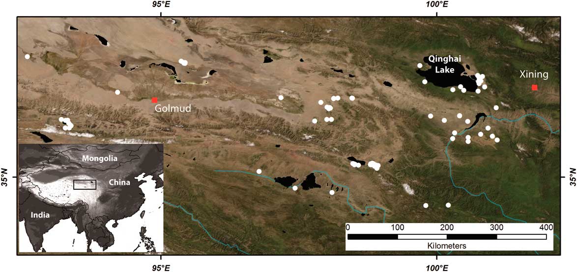
A further problem in the interpretation of aeolian sediments is the frequent reworking of older sediments, which results in a lower number of older sediment ages. Therefore, age distributions are biased towards younger ages (Telfer et al., Reference Telfer, Bailey, Burrough, Stone, Thomas and Wiggs2010; Bailey and Thomas, Reference Bailey and Thomas2014). This problem is obvious for presently active dunes that migrate downwind, resulting in a regular exposure of the sediment to sunlight (Lancaster, Reference Lancaster2008). However, reworking is not that obvious in fossil aeolian sections (Munyikwa, Reference Munyikwa2005; Telfer et al., Reference Telfer, Bailey, Burrough, Stone, Thomas and Wiggs2010). This is particularly the case in complex high-mountain environments such as those on the northeastern TP. The northeastern TP consists of different basins at elevations between 3000 and 4000 meters above sea level (m asl) and mountains of more than 5000 m asl (Fig. 1). Regions above 5000 m asl are partly glaciated (Owen et al., Reference Owen, Finkel, Haizhou, Spencer, Derbyshire, Barnard and Caffee2003). The climate in the area is mainly semiarid, with an annual precipitation of 100 to 500 mm (Maussion et al., Reference Maussion, Scherer, Mölg, Collier, Curio and Finkelnburg2013). Most precipitation falls during the Asian summer monsoon (ASM) period between June and September. Precipitation occurs as local torrential rainfall. The heavy rains have a profound influence on the redistribution of sediments (Stauch et al., Reference Stauch, IJmker, Pötsch, Zhao, Hilgers, Diekmann and Dietze2012). These intense rainfall events remove aeolian deposits on the slopes, resulting in the formation of gullies and redeposit the sediments in the valleys and basins.
(colour online) Overview of the northeastern Tibetan Plateau. White dots are locations of optically stimulated luminescence–dated sand.
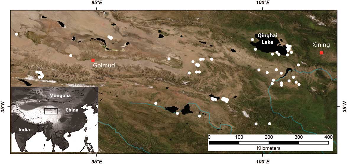
Aeolian sediments are widespread on the northeastern TP and range from a thin loess cover to fully developed dune systems (e.g., Lehmkuhl, Reference Lehmkuhl1997; Lehmkuhl and Haselein, Reference Lehmkuhl and Haselein2000; Sun et al., Reference Sun, Li, Muhs and Li2007; Lehmkuhl et al., Reference Lehmkuhl, Schulte, Zhao, Hülle, Protze and Stauch2014; Nottebaum et al., Reference Nottebaum, Lehmkuhl, Stauch, Hartmann, Wünnemann, Schimpf and Lu2014; Dong et al., Reference Dong, Hu, Qian, Lu, Zhang, Luo and Lyu2017). The main sediment sources are glacial outwash plains (e.g., Sun et al., Reference Sun, Li, Muhs and Li2007; Smalley et al., Reference Smalley, O’Hara-Dhand and Kwong2014), fluvial deposits, exposed lake beds (Lehmkuhl and Haselein, Reference Lehmkuhl and Haselein2000; Kaiser et al., Reference Kaiser, Lai, Schneider and Junge2010; IJmker et al., Reference IJmker, Stauch, Dietze, Hartmann, Diekmann, Lockot, Opitz, Wünnemann and Lehmkuhl2012; Yu et al., Reference Yu, Lai, An, Pan and Chang2015; Qiang et al., Reference Qiang, Jin, Liu, Song, Li, Li and Chen2016), and older aeolian archives (Stauch et al., Reference Stauch, Schulte, Ramisch, Hartmann, Hülle, Lockot and Diekmann2017). The aeolian system probably is not supply limited because abundant, thick Quaternary valley fill deposits throughout northeastern Tibet can be readily reworked. High wind speeds occur frequently on the northern TP (Maussion et al., Reference Maussion, Scherer, Mölg, Collier, Curio and Finkelnburg2013), which contribute to the erosion and result in a high transport capacity. Consequently, the actual sediment availability appears to be the most important factor for the initiation of aeolian transport, as has also been recognised for the large sand seas in northern China (Yang et al., Reference Yang, Li and Conacher2012).
This study evaluates the aeolian sedimentary archive in semiarid high-mountain environments on the northeastern edge of the TP to aid in palaeoenvironmental interpretation. We regard our study as robust because it represents a variable topography and a large number of OSL ages. A conceptual model is developed to synthesize the link between the phases of enhanced aeolian accumulation, as documented by increased numbers of OSL ages, and the underlying palaeoclimatic conditions. The results from the northeastern TP are compared with published records from the deserts of northern China and the Chinese Loess Plateau (CLP) to identify differences in the aeolian system between the high-mountain, semiarid area and the other regions hosting a wealth of aeolian sediment archives.
METHODS
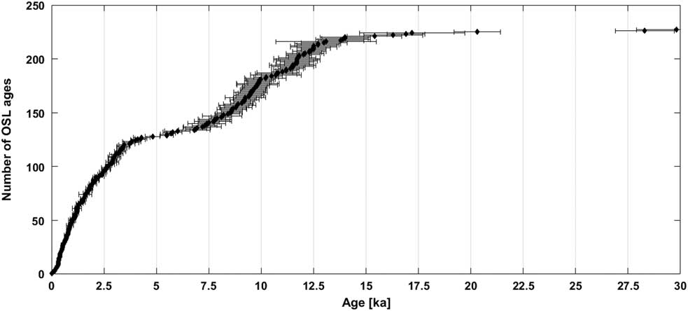
For this study, published OSL ages from the northeastern TP are analysed (Fig. 2) to elucidate the timing of sediment deposition and related forcing mechanisms. The data are based on the significantly expanded and updated database published by Stauch (Reference Stauch2016). The new data set (see the Supplementary Materials) comprises 232 OSL ages from sand deposits (Liu et al., Reference Liu, Lai, Madsen, Yu, Liu and Zhang2011, Reference Liu, Lai, Yu, Sun and Madsen2012, Reference Liu, Jin, Sun, Sun, Su and Zhang2013; Lu et al., Reference Lu, Zhao, Mason, Yi, Zhao, Zhou, Ji, Swinehart and Wang2011, Reference Lu, Jia, Gao, Shang, Li and Zhao2015; Stauch et al., Reference Stauch, IJmker, Pötsch, Zhao, Hilgers, Diekmann and Dietze2012, Reference Stauch, Lai, Lehmkuhl and Schulte2016, Reference Stauch, Schulte, Ramisch, Hartmann, Hülle, Lockot and Diekmann2017; Yu and Lai, Reference Yu and Lai2012, Reference Yu and Lai2014; Zhou et al., Reference Zhou, Zhu and Yuan2012; Qiang et al., Reference Qiang, Chen, Song, Liu, Li and Wang2013a, Reference Qiang, Jin, Liu, Song, Li, Li and Chen2016; Yu et al., Reference Yu, Lai and An2013; Lehmkuhl et al., Reference Lehmkuhl, Schulte, Zhao, Hülle, Protze and Stauch2014; Hu et al., Reference Hu, Yu, Dong, Jin, Luo, Wang and Lai2017). The aeolian sand deposits include dunes, sand sheets, and sandy sediments intercalated in loess deposits and fluvial or lacustrine sediments.
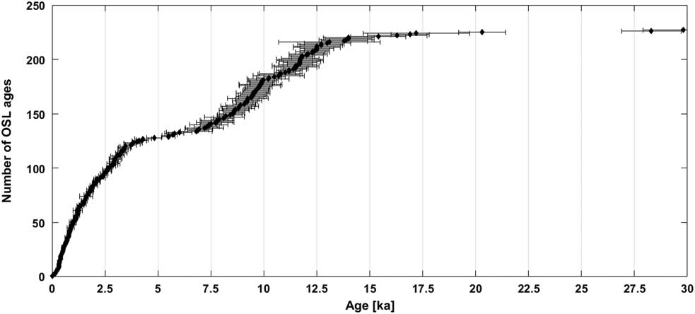
Optically stimulated luminescence (OSL) ages of sand deposits on the northeastern Tibetan Plateau for the last 30 ka.
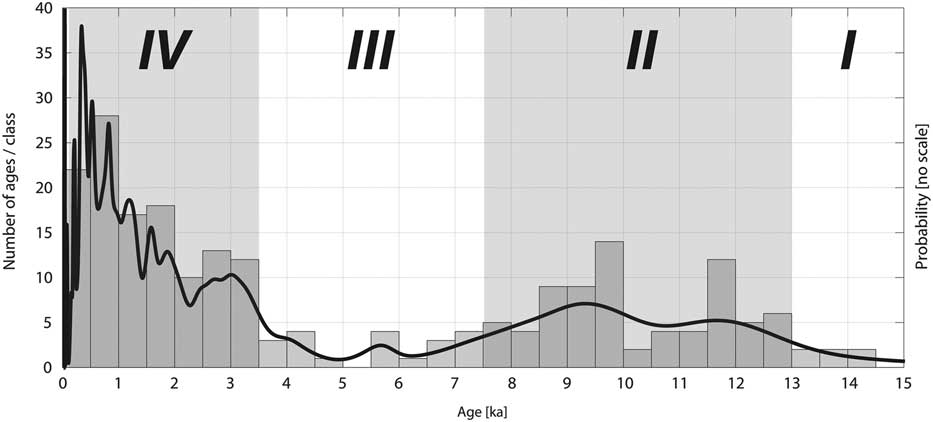
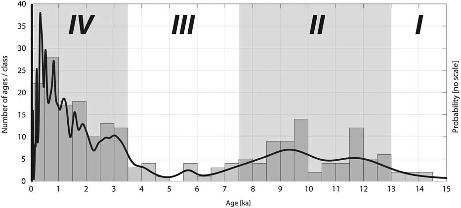
To highlight the different phases of aeolian activity, the data are presented in two ways (Fig. 3). At first, each mean age is binned in 500 yr classes. The resulting histogram allows an easy visualisation of phases with a larger number of OSL ages. Because each age indicates an individual accumulation event (Stauch, Reference Stauch2015), age clusters point to phases of higher aeolian accumulation. However, this kind of presentation does not include the uncertainty associated with each age. A method to overcome this weakness consists of probability density functions (pdfs). For each OSL age a pdf is calculated based on the mean and the standard deviation. Subsequently, the individual pdfs are summed for a cumulative pdf (Singhvi et al., Reference Singhvi, Bluszcz, Bateman and Rao2001; Lang, Reference Lang2003; Hesse, Reference Hesse2016). Nevertheless, because of increasing peak height with younger ages, the height of the peaks cannot be easily interpreted (Singhvi et al., Reference Singhvi, Bluszcz, Bateman and Rao2001; Hesse, Reference Hesse2016; Stauch, Reference Stauch2016). Furthermore, the age uncertainty is mostly not normally distributed (Galbraith, Reference Galbraith2010; Fitzsimmons et al., Reference Fitzsimmons, Cohen, Hesse, Jansen, Nanson, May and Barrows2013) and therefore not reliably represented by the standard deviation. For a more detailed discussion of the presentation of OSL ages with pdfs, see Hesse (Reference Hesse2016) and Stauch (Reference Stauch2016). To overcome at least some of the limitations, both methods are plotted in Figure 3.
Clustered optically stimulated luminescence (OSL) ages and cumulated probability density function (black line) for the last 15 ka from the northeastern Tibetan Plateau. Roman numbers indicate phases of high and low aeolian accumulation.
RESULTS
For the northeastern TP, 232 OSL ages are available from aeolian sand deposits. The oldest age in the data set is 97.5 ± 6.09 ka. However, only 11 ages are older than 14 ka (Fig. 2). Four different aeolian phases occurred during the last 30 ka. Hardly any preservation of aeolian sediments happened during the global last glacial maximum (gLGM) (phase I). Increased aeolian accumulation, as documented by the OSL ages, started at around 13 ka and lasted until 7.5 ka (Fig. 3) (II). In the early Holocene, strongest accumulation occurred from ~10 to 8.5 ka.
There are some noticeable variations in this second phase. After a period of strong aeolian accumulation from 12 to 11.5 ka, the histogram indicates a remarkable drop in OSL ages dating to 11.5–10 ka. However, this reduction in aeolian accumulation is hardly visible in the pdf, which includes the uncertainty of the OSL ages. Combining both approaches suggests that a reduction in aeolian accumulation most probably occurred during these 1.5 ka, but the presentation in the histogram overestimates the reduction.
During the mid-Holocene (III), accumulation was weak between 7.5 and 3.5 ka and nearly stopped for 1000 yr at ~5 ka (Fig. 2). A strong increase occurred since 3.5 ka (IV). The largest number of ages is available for the last 1000 yr (47). During the late Holocene, the pdf indicates fluctuating aeolian sand accumulation; however, this is not visualized in the histogram. This discrepancy documents the different information content in both methods again. Furthermore, short-term fluctuations in aeolian accumulation as in the late Holocene (IV) most probably also occurred during late glacial period and early Holocene (II) but are not resolved because of the larger standard deviation of the OSL ages. Additionally, the four phases are an integrated signal across the northeastern TP. Local variations might have occurred.
DISCUSSION
Comparison with neighbouring regions and palaeoclimatic proxies
Few ages are available for gLGM for the northeastern TP (Fig. 2). Climate on the northeastern TP was presumably cold and windy during that time (Herzschuh, Reference Herzschuh2006; An et al., Reference An, Colman, Zhou, Li, Brown, Jull and Cai2012). Many lakes desiccated (Herzschuh, Reference Herzschuh2006), and the pollen content in lake sediments was low (Wei et al., Reference Wei, Fan, Zhao, Ma, Shan, An and Yuan2015). Synchronously, aeolian transport is presumed to have been high on the northeastern TP. However, this phase of high activity is hardly preserved in the sedimentologic record because of the constant reworking of the deposits. Few ages are available from sections, which have been protected by a sediment cover or because of a sheltered topographic position (Stauch et al., Reference Stauch, Schulte, Ramisch, Hartmann, Hülle, Lockot and Diekmann2017). In a recent review, Li and Yang (Reference Li and Yang2016) compiled ages available in the INQUA Dune Database (state: 2013) from the deserts of northern China. The number of ages from glacial times is very limited. In contrast, enhanced deposition characterised the late glacial times (Li and Yang, Reference Li and Yang2016). This is in accordance with results from the southeastern margin of the Tengger Desert, where strong surface winds are inferred for the time between 19.1 and 11.4 ka (Qiang et al., Reference Qiang, Chen, Wang, Niu and Song2010). A set of older OSL ages was obtained from sand deposits at the northwestern margin of the CLP. Sand dunes were dated to pre–Marine Oxygen Isotope Stage 2, 35–25 ka (Long et al., Reference Long, Lai, Fuchs, Zhang and Yang2012). In contrast to the northeastern TP and the adjacent deserts, on the CLP accumulation rates were high during glacial times (Xiao et al., Reference Xiao, Porter, An, Kumai and Yoshikawa1995; An, Reference An2000; Porter, Reference Porter2001; Kohfeld and Harrison, Reference Kohfeld and Harrison2003), and these sediments are still preserved. Besides being considerably finer than the sediments analysed in this study, the area of the CLP was constantly covered by vegetation, even during glacial times (Jiang et al., Reference Jiang, Cheng, Yang and Yang2013), leading to the permanent fixation of the sediments. Additionally, the fine-grained sediments on the CLP are the result of long-distance transport from the deserts of northern and western China (Kukla, Reference Kukla1987; Vriend et al., Reference Vriend, Prins, Buylaert, Vandenberghe and Lu2011), whereas the sand deposits on the northeastern TP are of local origin (Lehmkuhl and Haselein, Reference Lehmkuhl and Haselein2000; Sun et al., Reference Sun, Li, Muhs and Li2007; Stauch et al., Reference Stauch, Pötsch, Zhao and Lehmkuhl2014; Stauch, Reference Stauch2015).
High accumulation on the northeastern TP started at 13 ka and lasted until 7.5 ka (phase II in Fig. 3). This pattern roughly resembles the high number of accumulated sands in the deserts of northern China, with enhanced accumulation rates starting in the late glacial period and lasting until the end of the early Holocene (Li and Yang, Reference Li and Yang2016). Similar results were obtained by an earlier study, which showed a high number of OSL ages from aeolian sands in the eastern deserts of China from around 11.5 to 8 ka (Mason et al., Reference Mason, Lu, Zhou, Miao, Swinehart, Liu, Goble and Yi2009). On the CLP, loess accumulation decreased during the early Holocene, and palaeosols were increasingly formed. This was interpreted as a signal of a gradual increasing ASM intensity (Wang et al., Reference Wang, Chen, Zhang and Chen2014a).
Local palaeoclimate reconstructions from the northeastern TP show a divergent picture. Several records are available for the Qinghai Lake. Li and Liu (Reference Li and Liu2017) used ostracod species assemblages to reconstruct climate variability. They inferred a cold and dry glacial climate and an increasing lake level after 15 ka. The lake level increased especially from around 11.6 to 7.4 ka (Li and Liu, Reference Li and Liu2017). Increasing precipitation values for the late glacial period and the early Holocene in the area of the Qinghai Lake were also reported by Shen et al. (Reference Shen, Liu, Wang and Matsumoto2005) and Colman et al. (Reference Colman, Yu, An, Shen and Henderson2007) and for other lakes on the northeastern TP (Mischke et al., Reference Mischke, Aichner, Diekmann, Herzschuh, Plessen, Wünnemann and Zhang2010; Opitz et al., Reference Opitz, Wünnemann, Aichner, Dietze, Hartmann, Herzschuh and IJmker2012; Qiang et al., Reference Qiang, Song, Chen, Li, Liu and Wang2013b; Wang et al., Reference Wang, Herzschuh, Shumilovskikh, Mischke, Birks, Wischnewski and Böhner2014b; Saini et al., Reference Saini, Günther, Aichner, Mischke, Herzschuh, Zhang, Mäusbacher and Gleixner2017). A shift to warmer and moister climate that started at around 15 ka was also inferred from a combination of several lake records (Wang et al., Reference Wang, Liu and Herzschuh2010). Therefore, the marked increase in OSL ages from the northeastern TP occurred synchronous to an increase in moisture in the area. However, this climate amelioration was not continuous. A short dry phase from 12.5 to 11.5 ka during the Younger Dryas stade was observed in many records (Yu and Kelts, Reference Yu and Kelts2002; Hong et al., Reference Hong, Hong, Lin, Zhu, Shibata, Hirota and Uchida2003; Wang et al., Reference Wang, Liu and Herzschuh2010, Reference Wang, Herzschuh, Shumilovskikh, Mischke, Birks, Wischnewski and Böhner2014b; Li and Liu, Reference Li and Liu2017). The later part of this phase is synchronous to a period represented by a high number of ages in the OSL chronology from the northeastern TP. Enhanced aeolian accumulation during the Younger Dryas stade was inferred for the southern margin of northern Chinese deserts. However, for this area a dry early Holocene climate and a rapid fixation of aeolian sediments were assumed (Mason et al., Reference Mason, Lu, Zhou, Miao, Swinehart, Liu, Goble and Yi2009). This rapid change is not consistent with the gradual changes inferred for the TP, which might be related to the generally thicker aeolian archives, which can reach up to 20 m, whereas the ones on the TP are only a few meters thick.
A low number of OSL ages from the TP are recorded from 7.5 until 3.5 ka, including a period of particularly low accumulation between 5.5 and 4.5 ka. Additionally, fluvial erosion of aeolian deposits occurred in several basins on the northeastern TP (Kaiser et al., Reference Kaiser, Schoch and Miehe2007; Stauch et al., Reference Stauch, Pötsch, Zhao and Lehmkuhl2014, Reference Stauch, Lai, Lehmkuhl and Schulte2016). A period of weak aeolian activity and enhanced soil formation from 8.2 to 2.5 ka was described from the deserts in eastern China (Mason et al., Reference Mason, Lu, Zhou, Miao, Swinehart, Liu, Goble and Yi2009). Additionally, limited aeolian activity characterised northern Chinese deserts from 5 to 4 ka (Li and Yang, Reference Li and Yang2016). In the Tengger Desert, northeast of the TP, aeolian activity dropped to a minimum from around 6 to 3 ka (Peng et al., Reference Peng, Dong, Han and Gao2016), and in the Mu Us dune field from 7 to 8 ka until 2.4 ka (Lu et al., Reference Lu, Miao, Zhou, Mason, Swinehart, Zhang, Zhou and Yi2005). Similarly, in the Hunshandake Sandy Land of northeastern China, a moister climate was inferred from the frequent occurrence of soils between 9.6 and 3 ka (Yang et al., Reference Yang, Wang, Liu, Li, Ren, Zhang, Ma, Rioual, Jin and Scuderi2013). On the CLP, low accumulation rates occurred from 7 to 3 ka (Kohfeld and Harrison, Reference Kohfeld and Harrison2003), whereas the highest numbers of OSL ages from palaeosols were related to the period between 8.2 and 3.4 ka (Wang et al., Reference Wang, Chen, Zhang and Chen2014a). This is consistent with moisture reconstruction from the CLP, where the highest moisture values occurred between 8 and 3 ka (Lu et al., Reference Lu, Yi, Liu, Mason, Jiang, Cheng and Stevens2013).
Climate reconstruction from Qinghai Lake showed the greatest moisture availability during the mid-Holocene (Shen et al., Reference Shen, Liu, Wang and Matsumoto2005; Li and Liu, Reference Li and Liu2017). A similar signal was obtained from proxy records from different lakes on the northeastern TP, like the Donggi Cona (Wang et al., Reference Wang, Herzschuh, Shumilovskikh, Mischke, Birks, Wischnewski and Böhner2014b), Kuhai Lake (Wischnewski et al., Reference Wischnewski, Mischke, Wang and Herzschuh2011), Genggahai Lake (Qiang et al., Reference Qiang, Song, Chen, Li, Liu and Wang2013b), and a loess-palaeosol sequence (Lehmkuhl et al., Reference Lehmkuhl, Schulte, Zhao, Hülle, Protze and Stauch2014). A wetter mid-Holocene was also evident from proxy records from the Hongyuan peat section (Hong et al., Reference Hong, Hong, Lin, Zhu, Shibata, Hirota and Uchida2003). These wetter climate conditions were caused by a stronger ASM (Hong et al., Reference Hong, Hong, Lin, Zhu, Shibata, Hirota and Uchida2003; Lu et al., Reference Lu, Yi, Liu, Mason, Jiang, Cheng and Stevens2013) and are more or less consistent over a large area in central Asia. These very moist climate conditions (Holocene moisture optimum) resulted in a strong reduction in aeolian activity.
A sharp increase in OSL ages from aeolian sands characterises the beginning of the late Holocene around 3.5 ka. The highest numbers of OSL ages in the entire record provide ages of <1 ka. A similar increase was observed in the deserts of northern China (Mason et al., Reference Mason, Lu, Zhou, Miao, Swinehart, Liu, Goble and Yi2009; Li and Yang, Reference Li and Yang2016; Peng et al., Reference Peng, Dong, Han and Gao2016). Additionally, during the late Holocene, several phases of enhanced accumulation of sands were observed on the northeastern TP and in the northern Chinese deserts (Stauch, Reference Stauch2016; Yang et al., Reference Yang, Wang, Long and He2017). However, theses short-term events, with durations of decades to centuries, are not completely resolved in Figure 3. The number of OSL ages from CLP palaeosols also decreased rapidly at around 3 ka, and loess deposition increased again (Wang et al., Reference Wang, Chen, Zhang and Chen2014a). The increase in OSL ages during the late Holocene is synchronous with a reduction in the precipitation on the northeastern TP. Several lakes recorded markedly drier conditions (Shen et al., Reference Shen, Liu, Wang and Matsumoto2005; Colman et al., Reference Colman, Yu, An, Shen and Henderson2007; Wang et al., Reference Wang, Herzschuh, Shumilovskikh, Mischke, Birks, Wischnewski and Böhner2014b; Li and Liu, Reference Li and Liu2017; Saini et al., Reference Saini, Günther, Aichner, Mischke, Herzschuh, Zhang, Mäusbacher and Gleixner2017), which is in agreement with results from peat deposits (Hong et al., Reference Hong, Hong, Lin, Zhu, Shibata, Hirota and Uchida2003; Liu et al., Reference Liu, Jin, Sun, Miao, Su and Zhang2014). This is attributed to a decline of ASM intensity. Furthermore, the human influence in the area strongly increased during the late Holocene (Schlütz and Lehmkuhl, Reference Schlütz and Lehmkuhl2009; Chen et al., Reference Chen, Dong, Zhang, Liu, Jia, An and Ma2015; Huang et al., Reference Huang, Liu, Dong, Qiang, Bai, Zhao and Chen2017b), which might have resulted in increased sediment mobilisation, reaccumulation, and thus in the high number of OSL ages during the last 1 ka.
The comparison between the timing of sediment accumulation on the northeastern TP and the neighbouring regions shows a similar timing of sediment accumulation in the deserts of northern China and a contrary behaviour for the gLGM and the late glacial period to the early Holocene on the CLP. Nevertheless, the interpretations of the increasing number in OSL ages are divergent. Although in the deserts of northern China the high accumulation rate was partly explained by enhanced aridity during the early Holocene (Mason et al., Reference Mason, Lu, Zhou, Miao, Swinehart, Liu, Goble and Yi2009), on the northeastern TP an increase in precipitation is assumed. The difference in interpretation might be related to the dissimilarity in the thickness of the archives. The greater thickness of the aeolian archives in the deserts of northern China might have supported the preservation of the sediments. During the mid- and late Holocene, the northeastern TP, the deserts of northern China, and the CLP show a similar behaviour in the timing of sediment accumulation.
Conceptual model
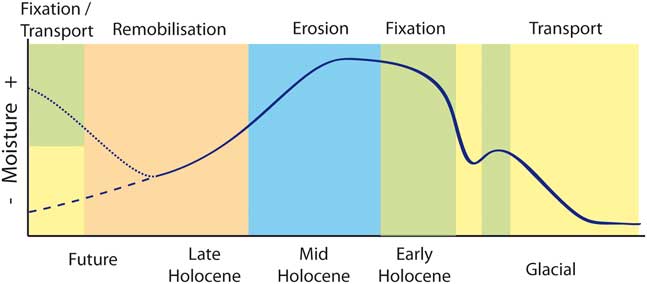
The analysis of the OSL ages in comparison with the independent palaeoclimatic data revealed four main phases of aeolian processes on the northeastern TP during the last 24 ka (Fig. 4). During glacial times, aeolian transport prevailed, but these sediments are poorly preserved. This was also observed for other sand deposits in China (Xu et al., Reference Xu, Lu, Yi, Vandenberghe, Mason, Zhou and Wang2015) and worldwide (Chase, Reference Chase2009; Mason et al., Reference Mason, Swinehart, Hanson, Loope, Goble, Miao and Schmeisser2011). In contrast to the northeastern TP and the deserts of northern China, the aeolian sediments on the CLP accumulated also under glacial conditions. A permanent vegetation cover favoured this sediment trapping (Jiang et al., Reference Jiang, Cheng, Yang and Yang2013). On the northeastern TP, cold and probably windy conditions prevailed during the gLGM, prohibiting the formation of a sufficient vegetation cover. Therefore, aeolian processes, presumably dominant on large parts of the northeastern TP, have not been preserved as aeolian landforms (e.g., dune fields, sand sheets), despite sufficient sediment supply, transport capacity, and a large sediment availability. Only in few locations, where sediments were protected from deflation, did the proxy record survive (Stauch et al., Reference Stauch, Schulte, Ramisch, Hartmann, Hülle, Lockot and Diekmann2017).
(colour online) Conceptual model of the interpretation of optically stimulated luminescence ages from aeolian sands on the northeastern Tibetan Plateau. The moisture curve is based on the effective moisture for monsoonal central Asia from Herzschuh (Reference Herzschuh2006). The left side of the figure includes two different future scenarios.
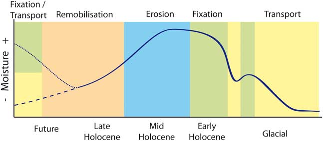
During the late glacial and the early Holocene, the number of OSL ages from aeolian sands increased. Aeolian sedimentary archives were preserved since this time. Because theses sediments are widespread on the northeastern TP (Lehmkuhl, Reference Lehmkuhl1997; Liu et al., Reference Liu, Lai, Yu, Sun and Madsen2012; Stauch et al., Reference Stauch, IJmker, Pötsch, Zhao, Hilgers, Diekmann and Dietze2012; Yu and Lai, Reference Yu and Lai2014; Qiang et al., Reference Qiang, Jin, Liu, Song, Li, Li and Chen2016), the constant fixation of sediments must have been much more efficient. A suitable trap is the development of a vegetation cover (Lancaster and Baas, Reference Lancaster and Baas1998). The development of the vegetation cover is related to an increase in moisture, which was related to the increasing strength of the ASM. Additionally, a vegetation cover reduces the amount of sediment available for deflation (Kocurek and Lancaster, Reference Kocurek and Lancaster1999). An additional factor might be a reduction in transport capacity because of lower wind speeds and an increase in sediment availability attributable to degrading permafrost as proposed by Xu et al. (Reference Xu, Lu, Yi, Vandenberghe, Mason, Zhou and Wang2015) for the Mu Us dune field. However, because the accumulation of sediments continued for ~5 ka, further mechanisms must be taken into account. First, the increase in moisture was a gradual process as indicated by various proxy records (Shen et al., Reference Shen, Liu, Wang and Matsumoto2005; Herzschuh, Reference Herzschuh2006; Li and Liu, Reference Li and Liu2017; Li et al., Reference Li, Dodson, Yan, Cheng, Zhang, Xu, Ni and Lu2017). This resulted in a gradual reduction in sediment availability. Denser vegetation covers progressively established and protected the formerly exposed landscape. In the mountain environment of the northeastern TP, local topographic position results in a diverse set of depositional environments, leading to a chronologically heterogeneous sedimentary record on a small spatial scale (Nottebaum et al., Reference Nottebaum, Stauch, Hartmann, Zhang and Lehmkuhl2015b; Stauch et al., Reference Stauch, Lai, Lehmkuhl and Schulte2016). Therefore, a relatively large number of sections in different topographic situations have to be utilised for a palaeoclimatic interpretation, which in turn results in a longer time span of aeolian accumulation. Furthermore, the increase in moisture was punctuated by phases of drier climate conditions like the Younger Dryas stade (Hong et al., Reference Hong, Hong, Lin, Zhu, Shibata, Hirota and Uchida2003; Wang et al., Reference Wang, Liu and Herzschuh2010; Li and Liu, Reference Li and Liu2017; Li et al., Reference Li, Dodson, Yan, Cheng, Zhang, Xu, Ni and Lu2017). This presumably extended the phase of aeolian transport by reactivating previously fixed sandy sediments. The remobilisation of sediments is evident by a large number of ages from 12 to 11.5 ka. Another important factor for the extended period of aeolian accumulation from the late glacial period until the early Holocene as recorded by the OSL ages is the high relief and the locally and temporarily strong fluvial activity (Stauch et al., Reference Stauch, IJmker, Pötsch, Zhao, Hilgers, Diekmann and Dietze2012), which provides large amounts of sediment for the basins of the northeastern TP. The importance of fluvial processes for aeolian processes has been highlighted before (Bullard and Livingstone, Reference Bullard and Livingstone2002; Field et al., Reference Field, Breshears and Whicker2009; Nottebaum et al., Reference Nottebaum, Lehmkuhl, Stauch, Lu and Yi2015a). The sediment storage in the upper part of the basins presumably emptied during the early Holocene. These arguments might also explain the low number of OSL ages after the Younger Dryas stade. Only few ages from aeolian sands are available covering the time between 11.5 ka and 10 ka. Nevertheless, no particularly moist period was recorded in the different proxy records from the area, which might have prevented aeolian transport because of a denser vegetation cover. The sediment storage in the lower parts of the basins might have been markedly reduced during the Younger Dryas stade because of intensive deflation. Thus, subsequently the deficit in sediment supply might have limited potential deflation. Only after further fluvial transport of sandy material could the deflation and, consequently, the accumulation of aeolian sands resume.
However, the record from the second phase is only a relict record. Erosion occurred on the northeastern TP during the subsequent two phases. During the mid-Holocene, the monsoon reached its maximum strength in the area, and consequently, the highest moisture values occurred (Hong et al., Reference Hong, Hong, Lin, Zhu, Shibata, Hirota and Uchida2003; Shen et al., Reference Shen, Liu, Wang and Matsumoto2005; Chen et al., Reference Chen, Wu, Chen, Zhou, Yu, Shen, Wang and Huang2016). Enhanced moisture availability facilitated the development of a dense vegetation cover, and sediment availability was low. Older aeolian archives were partly destroyed by fluvial processes (Kaiser et al., Reference Kaiser, Schoch and Miehe2007; Stauch et al., Reference Stauch, Pötsch, Zhao and Lehmkuhl2014, Reference Stauch, Lai, Lehmkuhl and Schulte2016).
During the late Holocene, a remobilisation of the sand by aeolian processes occurred. This remobilisation is caused by drier climate conditions, which are related to the weakening of the ASM. The remobilisation resulted in the high number of OSL ages in the last 3.5 and especially in the last 1 ka. In the basins, sediment availability increased again, providing sufficient material for deflation. Additionally, an increased human influence on the landscape is recorded at several sites in the area (Schlütz and Lehmkuhl, Reference Schlütz and Lehmkuhl2009; Chen et al., Reference Chen, Dong, Zhang, Liu, Jia, An and Ma2015; Huang et al., Reference Huang, Liu, Dong, Qiang, Bai, Zhao and Chen2017b). This might further have increased the number of open patches in the vulnerable landscape of the TP. Moreover, these ages are a classical example of the previously described bias towards younger sediments represented by the OSL data set (Telfer et al., Reference Telfer, Bailey, Burrough, Stone, Thomas and Wiggs2010; Bailey and Thomas, Reference Bailey and Thomas2014). During this remobilisation period, older aeolian archives are destroyed by deflation. However, short periods of drier climate occurred and resulted in short periods of enhanced aeolian accumulation. These periods are still evident in the sedimentary record (Stauch, Reference Stauch2016).
A comparison of the two main phases of aeolian activity during the Holocene (II and IV) indicates some important differences regarding the palaeoclimatic interpretation, despite that both phases indicate enhanced aeolian transport under relatively dry climate conditions. During phase II, the moisture increased, leading to a preservation of the aeolian sedimentary record. In contrast, the late Holocene phase (IV) is indicative of a remobilisation of aeolian sediments attributable to a shift to dry climate conditions.
In general, the aeolian sedimentary record is remarkably incomplete. The period with the highest aeolian activity is hardly recorded in geomorphological landforms. Generally, the results from OSL ages do not indicate the full length of the aeolian process. Only the final part of a phase of high aeolian activity is preserved. This holds true for not only the sand deposits on the northeastern TP, but also the deserts of northern China (Xu et al., Reference Xu, Lu, Yi, Vandenberghe, Mason, Zhou and Wang2015; Li and Yang, Reference Li and Yang2016). However, in other arid regions, like the deserts in southern Australia, there is an OSL age record from the gLGM (Lomax et al., Reference Lomax, Hilgers and Radtke2011), but this has been attributed to a patchy vegetation cover (Hesse, Reference Hesse2016). Another important parameter for the preservation of older aeolian sediments is the height and the morphology of the aeolian landform (Chase, Reference Chase2009). On the northeastern TP, the sand archives rarely reach a thickness of more than a few meters and can be easily eroded.
It can be further speculated that in the future a fifth period might occur (Fig. 4). If the presently relatively dry conditions on the northeastern TP prevail or might even be enhanced, all older archives would be reworked. This would result in the complete destruction of the late glacial and early Holocene aeolian palaeoclimatic archive. The effect might be similar to the destruction of the aeolian sedimentary archive from the last interglacial period, which was completely destroyed during subsequent dry periods on the northeastern TP. A shift to drier conditions on the northeastern TP has already been observed in the last decade (Huang et al., Reference Huang, Li, Fu, Chen, Fu, Dai and Shinoda2017a; Pang et al., Reference Pang, Wang and Yang2017). Because of its position at the margin of the midlatitude westerlies’ influence and the ASM, the region is potentially sensitive to climate change (Wang et al., Reference Wang, Chen, Huang and Zeng2017), and a further reduction in moisture is predicted (Yang et al., Reference Yang, Wu, Qin, Lin, Tang and Chen2014b; Huang et al., Reference Huang, Li, Fu, Chen, Fu, Dai and Shinoda2017a). However, the intensity of reworking depends on the strength and duration of the arid phase. In contrast, other regions, like the central and western TP, experience an increase in precipitation and rising lake levels (Yang et al., Reference Yang, Wu, Qin, Lin, Tang and Chen2014b; Deji et al., Reference Deji, Yang, Xu, Zhao, Li and Li2017), and this trend is partly expected also for the northeastern TP (Yang et al., Reference Yang, Qin, Wang, He, Melvin, Osborn and Briffa2014a). Under hypothetically moister climate conditions, a fixation of aeolian sediments would occur in the study area (Fig. 4).
CONCLUSION
The formation of aeolian archives on the northeastern TP is mainly controlled by sediment availability. Four different phases of higher and lower aeolian sand activity were deduced, and a conceptual model is developed to synthesize the link between these phases and the related palaeoclimate. During the gLGM, high aeolian activity occurred, but the sedimentary record has not been preserved until today. Under the dry and windy conditions, constant reworking of the sediment occurred. Consequently, aeolian processes are only incompletely recorded in the sedimentary archives. During the late glacial period and the early Holocene, the moisture in the area increased because of the strengthening of the ASM. This resulted in a denser vegetation cover and the permanent fixation of the sediments. However, because of the complex topography and the gradual increase in precipitation, aeolian activity continued for ~5 ka. Furthermore, a relatively short increase in aeolian activity between 12 and 11.5 ka indicates a return to dry climate conditions during the Younger Dryas stade. The mid-Holocene is characterised by a reduction in aeolian activity and fluvial reworking of aeolian archives. Aeolian accumulation resumed during the late Holocene from around 3.5 ka onwards. This is caused by a reduction in moisture on the northeastern TP. However, frequent changes in aeolian activity occurred during the late Holocene. Despite that the early and late Holocene are characterised by more arid conditions than the mid-Holocene, both periods hold distinctly different climatic information. While the early Holocene is indicative of a shift towards moister climate conditions, the late Holocene shows the opposite trend. Moreover, assuming that the presently dry conditions continue and/or increase, the generally low thickness of aeolian sand archives on the northeastern TP will allow a complete removal of the sedimentary proxy record.
SUPPLEMENTARY MATERIAL
To view supplementary material for this article, please visit https://doi.org/10.1017/qua.2018.35