


Introduction
This paper represents Phase 1 of a project focused on the irrigation systems around Eridu, in an arid and abandoned area between the western desert of Iraq and the modern course of the Euphrates. Our research represents the first scientific dating of canals and crevasse splay features at Eridu. In general, the chronology of water management features is poorly understood, and scholarship has long relied on dating canals by association with settlements (e.g., Adams Reference Adams1981). In the last few years, several studies have targeted different water management features throughout southern Iraq for scientific dating evidence, and therefore a clearer and more empirical chronology is emerging to which our research contributes. Radiocarbon dates from a levee cut near Nippur yielded dates as early as the fourth millennium B.C. (Wilkinson et al. Reference Wilkinson, Rayne and Jotheri2015). Most recently, Egberts et al. (Reference Egberts, Jotheri, Di Michele, Baxter and Rey2023) sampled seven canals around Girsu (occupied between 4800 and 1600 B.C.), radiocarbon dating shells and charcoal. The dates obtained fell between 5324–5132 cal B.C. (from a canal, date remodelled as 5015–4706 B.C.) to 2456–2204 B.C. (from lacustrine deposits from the tell, possibly representing a harbour, date corrected to 2100–1800 B.C.). Radiocarbon dating was also recently carried out at Abu Tbeirah (Forti et al. Reference Forti, Romano, Celant, D’Agostino, Di Rita, Jotheri, Magri, Mazzini, Tentori and Milli2022), in this case including crevasse splays yielding a date of 4572–4292 cal B.P.
Crevasse splays are a well-known feature of southern Mesopotamian geomorphology and can be natural or human-modified. They are spreads of sediment and traces of former channels in fluvial floodplains, often fan-like (Colombera and Mountney Reference Colombera and Mountney2021), which are clear in satellite images. The gradient of the plain in southern Iraq is very low. The Euphrates therefore flows 1-2 meters above the plain on the wide crest of natural levees made up of deposited sediments (Wilkinson et al. Reference Wilkinson, Rayne and Jotheri2015). This situation enables diversion of water down the levee slope, taking advantage of the gradient of the levee slope in the process of guiding water away from the river or main channel. This process led to channels being modified and extended over time by local communities. Water taken off levees in this way either naturally or deliberately creates the fans of sediment (Buringh Reference Buringh1960; Wilkinson et al. Reference Wilkinson, Rayne and Jotheri2015). Canals may also have a higher hydraulic head than natural channels and thereby also lead to the formation of crevasse splays (Colombera and Mountney Reference Colombera and Mountney2021). We originally proposed that these early stages of irrigation technology in southern Mesopotamia could have evolved into a regular system of channels with fields of similar size (Wilkinson et al. Reference Wilkinson, Rayne and Jotheri2015).
Clarity is needed, however, about exactly where crevasse splays fit in the development of irrigation technology in the region, because dated archaeological evidence is scarce. Wilkinson (Reference Wilkinson2003: 87) suggested that early irrigation would have used levee slopes and crevasse splays, eventually modifying these channels. In our 2015 paper we proposed that crevasse-splay systems could have been gradually modified and transformed into a herringbone layout of canals flowing on low levees, with offtakes then able to flow downslope to attain steeper gradients (Wilkinson et al. Reference Wilkinson, Rayne and Jotheri2015). Wilkinson proposed that larger-scale irrigated networks were constructed from the third millennium B.C. (Reference Wilkinson2003: 89), citing cuneiform texts which refer to canal cleaning, followed by regional-scale systems in the second millennium B.C. onwards (ibid: 9). However, he acknowledged that, locally, farms could have relied on smaller canals supporting date palms and narrow fields (ibid: 91). Originally, crevasse splays could have supported small areas cultivated by one or two households (Wilkinson et al. Reference Wilkinson, Rayne and Jotheri2015).
Wilkinson (Reference Wilkinson2003) emphasises that there is a paucity of evidence for these early stages of irrigation. This may be in part due to processes of sedimentation and wind erosion (Wilkinson et al. Reference Wilkinson, Rayne and Jotheri2015). Although the chronology of water management is starting to attract further scholarship, there are very few channels which are scientifically dated. Increasingly, water systems in the Near East have been mapped by remote sensing studies using satellite imagery and aerial photography that offer a bird’s eye view of the landscape. Several recent studies have used satellite imagery to map channel features in Mesopotamia in detail (e.g. Brown et al. Reference Brown, Jotheri, Rayne, Abdalwahab and Andrieux2025; Buławka and Orengo Reference Buławka and Orengo2024; Cigna et al. Reference Cigna, Tapete, Rayne, Lavris Makovics, Irvine, De Gruchy and Jotheri2024; Forti et al. Reference Forti, Romano, Celant, D’Agostino, Di Rita, Jotheri, Magri, Mazzini, Tentori and Milli2022; Hammer et al. Reference Hammer, Stone and McMahon2022a; Iacobucci et al. Reference Iacobucci, Troiani, Milli, Mazzanti, Piacentini, Zocchi and Nadali2020; Jotheri et al. Reference Jotheri, Rokan, Al-Ghanim, Rayne, de Gruchy and Alabdan2025; Le Doare et al. Reference Le Doaré, Mura and Giraud2023; and Rayne and Donoghue Reference Rayne and Donoghue2018). Le Doare et al. (Reference Le Doaré, Mura and Giraud2023) used a set of identification criteria (following Jotheri Reference Jotheri, Altaweel and Zhuang2018) to record a variety of channel types in the Uruk–Larsa region, including canals and crevasse splays. Forti et al. (Reference Forti, Romano, Celant, D’Agostino, Di Rita, Jotheri, Magri, Mazzini, Tentori and Milli2022) also used remote sensing to trace crevasse splay features around the site of Abu Tbeirah (Forti et al. Reference Forti, Romano, Celant, D’Agostino, Di Rita, Jotheri, Magri, Mazzini, Tentori and Milli2022: fig 7). Iacobucci et al. (Reference Iacobucci, Troiani, Milli and Nadali2023) mapped and classified channel features at Tell Zurghul, noting that the canals tend to be straight lines with a herringbone or trellis alignment, while natural channels are much more sinuous.
These mapped channel systems provide useful data on the layout of water management, but scientific dating of these features is needed in order to understand their chronology within their archaeological and historical context and to understand the trajectory of crevasse splay > herringbone system > larger-scale canals. Our project addresses this, aiming to: a) conduct a programme of mapping (for initial results see Jotheri et al. Reference Jotheri, Rokan, Al-Ghanim, Rayne, de Gruchy and Alabdan2025) and AMS (Accelerator Mass Spectrometry) dating of crevasse splays, canals and traces of the relict Euphrates around the site of Eridu (Tell Abu Shahrein), and b) using this data, reconstruct the development of irrigation around Eridu.
Eridu and its landscape
Irrigation is a necessity in southern Mesopotamia, where current evidence indicates the mean annual precipitation throughout the Holocene to today is often 100–200mm per year, at times lower and only occasionally slightly higher (particularly to the east between the Tigris and Zagros Mountains, see Hewett et al. Reference Hewett, de Gruchy and Lawrence2022). This level of annual precipitation is too low to rely on for cultivation and even falls under the ‘Zone of Uncertainty’, where annual variability in rainfall could allow for rainfed agriculture during wetter years (Hewett et al. Reference Hewett, de Gruchy and Lawrence2022).
Based on current evidence, without water management, throughout the whole of the Holocene, agriculture would have been completely impossible across the region, except on occasion between the Tigris River and Zagros Mountains (Hewett et al. Reference Hewett, de Gruchy and Lawrence2022). However, based on phytolith and diatom evidence for date palm trees in soils from boreholes near Uruk and Nippur, southern Mesopotamia has been ‘habitable’ since the eighth millennium B.C. and possibly earlier (Altaweel et al. Reference Altaweel, Marsh, Jotheri, Hritz, Fleitmann, Rost and Lintner2019; Altaweel Reference Altaweel2019). From the eighth through sixth millennium B.C., oak trees were also present as far south as the area around Uruk (Altaweel et al. Reference Altaweel, Marsh, Jotheri, Hritz, Fleitmann, Rost and Lintner2019).
Since the twentieth century, archaeologists have recorded ancient and historic channels across southern Iraq using aerial and satellite imagery, as well as field survey. Robert McCormick Adams (Reference Adams1981) mapped alignments of sites, which he linked to the presence of former channels and suggested that there had been major shifts in the positions of the rivers. Before Adams, Albrecht Goetze (Reference Goetze1953) published a reconstruction of canals, and Thorkild Jacobsen (Reference Jacobsen1960) mapped canals associated with the site of Ur, based on the linear arrangement of sites located through field survey and historical evidence from texts. In the twenty-first century, a growing volume of remote sensing data has allowed detailed mapping of the landscape. High resolution and very high resolution satellite imagery, including imagery available via Google Earth, and declassified historic CORONA, Hexagon and other historical images, have allowed features to be digitised, including in locations where they are no longer visible in the landscape (e.g., Deadman et al. Reference Deadman, Jotheri, Hopper, Almayali, al-Luhaibi and Crane2025; Gussone et al. Reference Gussone, Fowler and Schneider2023; Hammer et al. Reference Hammer, FitzPatrick and Ur2022b; Philip et al. Reference Philip, Donoghue, Beck and Galiatsatos2002; Rayne Reference Rayne, Kennedy and Besard2025; Rayne Reference Rayne2015; Ur Reference Ur, Comer and Harrower2013). Crucial information about the gradient and morphology of channels is supplied by elevation models (Hritz and Wilkinson Reference Hritz and Wilkinson2006). Understanding of these landscapes has also benefited from more recent geoarchaeological and geomorphological approaches (e.g., Wilkinson Reference Wilkinson2003) emphasising the complex processes of erosion and sedimentation.
These data are refining our understanding of water in the alluvial plains as dynamic and complex (Hritz et al. Reference Hritz, Al-Hawi, Al-Sudani, Albadran, Pournelle, Lawrence, Altaweel and Philip2020). The complex palimpsest of water management in Mesopotamia represents thousands of years of ‘hydraulic landscapes’, which transformed their environments (Wilkinson and Rayne Reference Wilkinson and Rayne2010). The Tigris and Euphrates rivers form anastomosing networks of branching channels which rejoin to form the Shatt al-Arab (Wilkinson et al. Reference Wilkinson, Rayne and Jotheri2015) and which have developed and changed over time. Adams (Reference Adams1981) suggested that the Euphrates shifted in the second millennium B.C., with some of its branches declining. Canals were constructed in response to these changes, in order to maintain flow to cities (Hritz et al. Reference Hritz, Al-Hawi, Al-Sudani, Albadran, Pournelle, Lawrence, Altaweel and Philip2020: 236). Early texts provide some insight into how water was managed over time in Mesopotamia. By the middle of the third millennium B.C., documents indicate different categories of canals and control devices and royal construction projects of herringbone layout (Rost Reference Rost2017: 9). Distribution of water through various canals was controlled by the use of reed bundles (Rost Reference Rost2017: 8). Second millennium B.C. texts describe how Hammurapi (1792–1750 B.C.) undertook dredging work to restore water to cities, including Eridu (Rost Reference Rost2017: 13).
Eridu itself has early origins in the sixth millennium B.C. and was occupied into the first millennium B.C. with sequences of mud-brick structures. Pioneering excavations at the constituent mounds of the site were undertaken in 1946–1949 by the State Board of Antiquities and Heritage of Iraq (Safar et al. Reference Safar, Mustafa and Lloyd1981), after a series of smaller-scale studies by the British Museum (Taylor Reference Taylor1855). The alluvial, low-lying and still somewhat marshy environs of Eridu were emphasised in this report (Safar et al. Reference Safar, Mustafa and Lloyd1981). Remains of fish were found as temple offerings, and they are interpreted as evidence for the importance of marshy environments (Oates Reference Oates1960: 50). This environment also enabled the breeding of cattle and pigs (Leick Reference Leick2001: 16). Oates suggested that hunting, fishing, herding and simple agriculture could have been undertaken in the marshes (Reference Oates1960: 49). Remains of plough furrows of unknown date were recorded close to the mound (Safar et al. Reference Safar, Mustafa and Lloyd1981: 30).
Eridu was a particularly sacred location in Mesopotamian myth, regarded as the ‘first’ city and temple, with close proximity to marshy land/water (Safar et al. Reference Safar, Mustafa and Lloyd1981: 33; Leick Reference Leick2001: 2- 3). It consists of several mounds, dating from the Ubaid to the Achaemenid periods (Safar et al. Reference Safar, Mustafa and Lloyd1981: 30–32). The earliest building excavated at Eridu was a structure interpreted as a pre-Ubaid shrine (Safar et al. Reference Safar, Mustafa and Lloyd1981: 45). Subsequently a mudbrick temple of the Ubaid era (5600–4000 B.C.) was replaced by an ongoing sequence of similar structures over this period (Safar et al. Reference Safar, Mustafa and Lloyd1981; Leick Reference Leick2001: 6). Houses dated to the Ubaid period were also excavated (Safar et al. Reference Safar, Mustafa and Lloyd1981). Based on funerary pottery, a cemetery was dated to this period and may have served the population of the local area, including the study area of this project (Safar et al. Reference Safar, Mustafa and Lloyd1981; Leick Reference Leick2001: 13). The ceramic and architectural remains from Eridu have been interpreted as suggesting cultural continuity from the Ubaid through the Uruk period (Oates Reference Oates1960: 45–47). During the Uruk period, the site appears to have been dominated by its rebuilt shrine (Safar et al. Reference Safar, Mustafa and Lloyd1981: 46). After the Uruk period, Eridu appears to have declined, with later episodes of restoration (Safar et al. Reference Safar, Mustafa and Lloyd1981: 46). Recently, further excavations at Eridu have been underway and recorded a possible drainage structure (D’Agostino et al. Reference D’Agostino, Rendu Loisel, Quenet and Serra2020). Excavations and survey since 2018 targeted some of the mounds and cemeteries of Eridu, refining knowledge of the sequences of key structures including the temple on Mound 1 where several stages of construction were found (Quenet et al. Reference Quenet, D’Agostino, Loisel, Galluser, Jotheri, Koerin, Makinson, Rambeau and Salomon2025; 281). Cuneiform sources dating from as far back as the Sumerian period reference abandonment and restorations of the city (Quenet et al. Reference Quenet, D’Agostino, Loisel, Galluser, Jotheri, Koerin, Makinson, Rambeau and Salomon2025: 286). Shells taken from the mound of Eridu were dated by AMS to 5770 cal. B.C. and 2291 cal. B.C. (Hritz et al. Reference Hritz, Pournelle and Smith2012).
The Area of Interest (AOI) of our study could represent part of the zone of early agriculture, as well as exploitation of other resources including fish, which supported Eridu. The AOI encompasses several crevasse splays and canals of unknown date fanning out from the relict Euphrates close to Eridu (see Fig. 1, also see Jotheri et al. Reference Jotheri, Rokan, Al-Ghanim, Rayne, de Gruchy and Alabdan2025). The area is generally flat, with the ancient natural river levees, canal levees, and crevasse splays elevated. The natural river levees’ elevations are generally less than 1 meter high, and the crevasse splays and ancient canal levees are less than 0.4 meters high.
Location of study area within Iraq. Background image: VISION-1 2020-07-02 (©Airbus D&S 2021)

Fig. 1 Long description
Panel A: A political map of Iraq highlighting the study area around Eridu. The map shows major cities such as Baghdad, Ramadi, Karbala, Hilla, Diwaniyah, Kut, Amarah, Nasiriyah, Ur, and Basrah. The Euphrates River and Tigris River are prominently marked, with the study area located between the western desert of Iraq and the modern course of the Euphrates. The map includes a scale bar indicating distances up to 50 kilometers. Panel B: A detailed map of the Eridu region showing specific splay areas labeled as Splay 1, Splay 2, Splay 3, Splay 4, and Splay 5. The map includes markers for various sampling locations with labels such as ER1, ER2, ER3, ER4, and ER5, each with associated depth measurements in centimeters. The Relict Euphrates is also marked on the map.
Some channels appear to overlay others, suggesting a sequence of irrigation over time. In satellite imagery, the former course of the Euphrates is clear, flowing close to Eridu. This course is represented by sequences of meander scroll features that were formed by migration of the river, leading to a pattern of parallel lines (Jotheri and Allen Reference Jotheri, Allen, Lawrence, Altaweel and Philip2020: 287). It curves past Eridu and cuts through a gap in a ridge to the north. In this area, there are several crevasse splays and layers of channels linked to these traces of the former Euphrates. Hritz et al. (Reference Hritz, Al-Hawi, Al-Sudani, Albadran, Pournelle, Lawrence, Altaweel and Philip2020) mapped some of the channels closest to the mound. This course of the river was active in the second millennium B.C. (Hritz et al. Reference Hritz, Al-Hawi, Al-Sudani, Albadran, Pournelle, Lawrence, Altaweel and Philip2020: 244) and was recorded by previous investigations (e.g., Buringh Reference Buringh1957). More recent near-surface samples gave dates of the first millennium B.C., with deeper excavations giving dates of the fifth–sixth millennium B.C. (Hritz et al. Reference Hritz, Al-Hawi, Al-Sudani, Albadran, Pournelle, Lawrence, Altaweel and Philip2020). Dating of this former river channel could give a terminus ante quem for the canals and crevasse splays that divert from it, both at Eridu and along the rest of its path.
Methods
Remote sensing and image interpretation
Undated and undifferentiated mapping was first undertaken (Jotheri et al. Reference Jotheri, Rokan, Al-Ghanim, Rayne, de Gruchy and Alabdan2025) and is classified in detail here for the first time. A time series of different satellite images was examined to identify, classify and digitise channel features (Table 1). Modern, free, very high resolution satellite imagery was obtained via Airbus and Google Earth and used for digitising channels around Eridu using GIS software (ArcMap and QGIS). While Google Earth and imagery streamed via the GIS software was only used to display imagery in RGB, without its radiometric properties, it can be used for image interpretation. A series of quarterly high-resolution VISION-1 images of 0.9 m resolution (March 2020, June 2020, September 2020, December 2020, and May 2021) was ordered from Airbus through a temporary scheme of Jisc (since discontinued). CORONA satellite imagery was used to map channels at Eridu which were visible in 1968–69. Although higher resolution modern imagery is available, declassified imagery such as CORONA remains invaluable as a historic record of the landscape that pre-dates decades of development.
Satellite Datasets Used for Mapping Water Management Features

Table 1: Long description
A table with three rows and three columns. The columns are labeled Sensor, Image dates, and Spatial resolution (m). The row labels are CORONA, VISION-1, and Google Earth (various sensors of CNES/Airbus/MAXAR). Row 1: CORONA, 04.1968, 03.1969, 2. Row 2: VISION-1, 03.2020–05.2021, 0.9. Row 3: Google Earth (various sensors of CNES/Airbus/MAXAR), 2002–2020, 0.3–1.
This range of imagery provided resolutions up to 0.31–0.95 m, which enables the mapping of smaller and narrower features. For this project, the very high-resolution satellite imagery was used to detect and trace any channels as narrow as around 50–100 centimetres in width. A process of image interpretation was applied, using our experience of identifying water management systems which tend to have a distinctive appearance in satellite imagery.
Our workflow was as follows: Examination of features using CORONA, Google Earth and VISION-1 imagery, which give a ‘time series’ from the 1960s to 2023. Exclusion of features which the time series shows are modern (post 1960s). Digitisation, done using VISION-1 and imagery streamed via QGIS as a base. Classification of features as: a) canal, b) qanat, c) crevasse splay, or d) unknown linear feature (ULF). Features were classified as ULF in cases where we were not certain if they were ancient canals, fragments of modern canals, or trackways. Future fieldwork might be able to confirm/correct interpretations of these features. Calculation of angles of degrees of each channel, using the appropriate tool in QGIS to aid with visual interpretation. Separation of canals into distinct systems and labelling based on: a) their abstraction point, b) their proximity/interconnections to each other, c) visual inspection of their overall bearing and alignment in relation to each other.
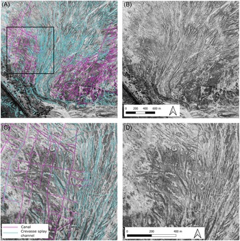
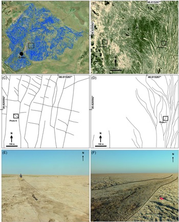
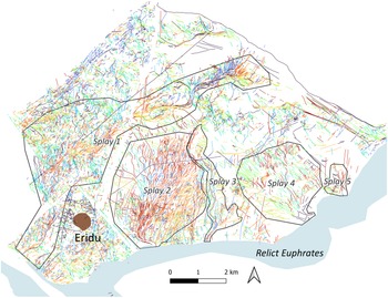
This process was possible because disused and ancient water channels are distinctive as dark linear features in the archaeological landscape (Figs. 2D and 3E). Their relative darkness is caused by continued, increased moisture contained in the (former) depressions of the former channels and due to fine sand infill which is more permeable than the sand of the surrounding area, leading to a difference in appearance. The channels can take different shapes depending on the type of features they represent and the degree of human construction or modification. Canals are straight (Figs. 2A and 2C), while natural channels are more sinuous (Figs. 3D and 3F). Crevasse splays originate at a waterway, such as a river or large canal, and form a fan-shaped collection of somewhat sinuous linear channels across the landscape, representing where the water flowed from the break in the side of the riverbank or canal levee. Linear features assumed to be channels were traced from these different images (Fig. 2). Although some roads can look like paleochannels, they tend to be narrower (Jotheri and Allen Reference Jotheri, Allen, Lawrence, Altaweel and Philip2020: 295). Digitised channels were then sorted into distinct canal and separate crevasse splay systems based on their connections, degree of sinuosity and compass angle. This process of interpretation was aided by using a colour palette to display the channel segments by compass angle alone (Fig. 4). For example, in Fig. 4, mapped channels oriented northwest–southeast are shown in orange/red, while those that are oriented more east–west appear darker. Meanwhile, crevasse splay 4, which originates in the middle of the southern edge of the image and fans outward to the north, is mainly green. Crevasse splay 1 can be seen originating near the north corner of the enclosed area around the site of Eridu and flowing to the northeast in bright orange changing to blue.
Different types of channels can be identified from satellite imagery using image interpretation based on their characteristics. A) and B) Rectilinear systems of canals (system 1) spread out on either side of a crevasse splay (splay 2) and location of C and D. C) and D) Closeup. It is possible to see that the straight lines of the canals overlay some parts of the crevasse splay. The crevasse splay channels are more meandering and sinuous than the canals. Background image: VISION-1 2020-07-02 (©Airbus D&S 2021)

Examples of appearance of canals in satellite images and on the ground. A) Google Earth images of the Eridu region (see Figure 1 for location) showing all the reconstructed canals and crevasse splays mapped using satellite images. B) One of the selected areas ground-truthed during fieldwork. C) The reconstructed canals in the ground-truthed area. D) The reconstructed crevasse splays in the ground-truthed area. E) Field photograph showing one of the reconstructed canals in the area. F) Field photograph showing one of the reconstructed crevasse splays in the area. Satellite image via Google Earth: Google, CNES/Airbus 11.2020

Fig. 3 Long description
Panel A: A satellite image of the Eridu region displaying reconstructed canals and crevasse splays mapped using satellite images. Panel B: A ground-truthed area selected during fieldwork, showing the landscape with visible channels. Panel C: A diagram of the reconstructed canals in the ground-truthed area, illustrating their straight lines and alignment. Panel D: A diagram of the reconstructed crevasse splays in the ground-truthed area, showing their more sinuous patterns. Panel E: A field photograph of one of the reconstructed canals in the area, with a person standing nearby for scale. Panel F: A field photograph of one of the reconstructed crevasse splays in the area, highlighting the greenspace splash.
Channel segments and unknown linear features colour-coded by compass degree angle, allowing easier interpretation of distinct, separate systems

Fieldwork and radiocarbon dating
Image interpretation allowed us to digitise, interpret and separate the channels and splays into several distinct systems (Fig. 5). Fieldwork was then undertaken to investigate these systems. For this pilot study, we were able to excavate a small number of trenches at a sample of the channel systems (indicated with circles on Fig. 5). Fieldwork was undertaken in October 2020 by Dr Jaafar Jotheri and Dr Raheem Abdan, assisted by students from the University of Thi-Qar. Locations were selected to encompass the main irrigation systems on the crevasse splays to the east of Eridu. We aimed to excavate significant channels and channel conjunctions, as well as trenches across the relict Euphrates. The digitised channel networks were visited on the ground to confirm our interpretations and to select the best locations for sampling. Some of the digitised canals were clearly traceable on the ground (Fig. 6) while others were not very visible. These features have a slight elevation of less than 0.4 meters above the plain, so in some cases are topographically recognisable. The tone or colour of the canal levees is also sometimes different from the canal bed.
Digitised channels, crevasse splays and sampling locations

Fig. 5 Long description
A map of ancient water management systems in the Uruk-Larsa region, showing channels, crevasse splays, and sampling locations. The map includes various channel systems labeled as System 1, System 2, System 3, System 4, and System 5. It also shows splay areas labeled as Splay 1, Splay 2, Splay 3, Splay 4, and Splay 5. Sampling locations are marked with pink dots and labeled with identifiers such as ER1-55cm, ER1-40cm, ER2-60cm, ER3-45cm, ER4-70cm, and ER5-60cm. The map uses different colors and line styles to distinguish between unknown linear features, roads, crevasse splays/natural features, and relict Euphrates. The scale bar at the bottom right indicates distances up to 2 kilometers.
Recording an ancient irrigation channel in the field, October 2020. The channel is distinct as a straight line of darker soil

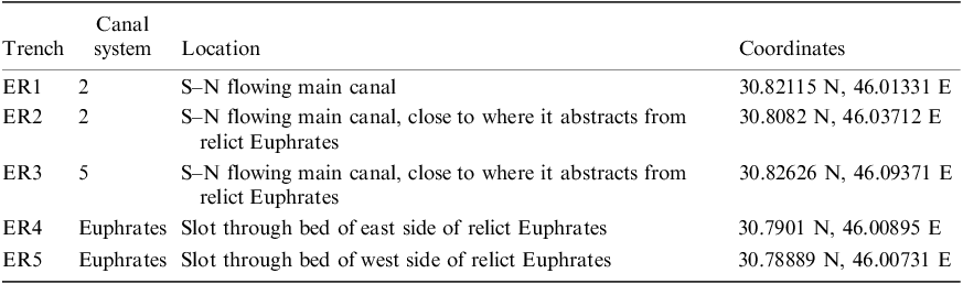
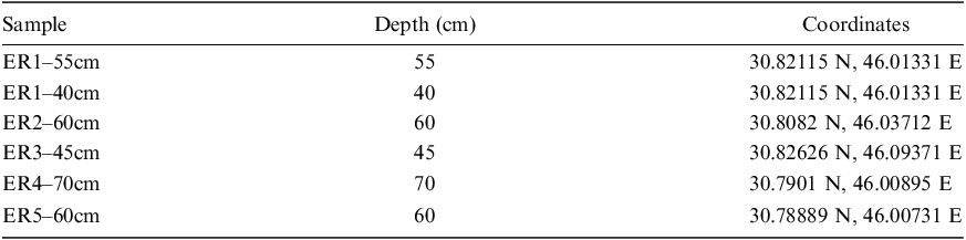
We selected sites (Table 2) representing a range of key features: the clearest and most extant canal system (System 2), trenches ER1 and ER2; a canal system where the main channel is merged with a crevasse splay channel, System 5, ER3; and the relict channel of the Euphrates, trenches ER4 and 5. In total, five trenches across clear channel profiles were excavated, photographed and recorded at each location using GNSS (see Tables 2–3 and Fig. 5 for trench locations and sample depths, Figs. 7–10 for each trench). It was found that the area was mostly covered by 10 to 20 cm of disturbed sediments that are heavily affected by eolian weathering, rains and vegetation cover. The common sediments in the canal beds are sandy (very fine sand, sandy silt and sandy clay).
Trench Locations
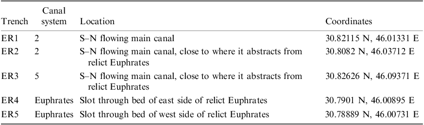
Table 2: Long description
A table with five rows and four columns detailing trench locations. The columns are labeled Trench, Canal system, Location, and Coordinates. Row 1: Trench ER1, Canal system 2, Location S-N flowing main canal, Coordinates 30.82115 N, 46.01331 E. Row 2: Trench ER2, Canal system 2, Location S-N flowing main canal, close to where it abstracts from relict Euphrates, Coordinates 30.8082 N, 46.03712 E. Row 3: Trench ER3, Canal system 5, Location S-N flowing main canal, close to where it abstracts from relict Euphrates, Coordinates 30.82626 N, 46.09371 E. Row 4: Trench ER4, Canal system Euphrates, Location Slot through bed of east side of relict Euphrates, Coordinates 30.7901 N, 46.00895 E. Row 5: Trench ER5, Canal system Euphrates, Location Slot through bed of west side of relict Euphrates, Coordinates 30.78889 N, 46.00731 E.
Sample list

Table 3: Long description
A table with five rows and three columns. The columns are labeled Sample, Depth (cm), and Coordinates. The rows list different samples with their respective depths and coordinates. Row 1: Sample ER1–55cm, Depth 55 cm, Coordinates 30.82115 N, 46.01331 E. Row 2: Sample ER1–40cm, Depth 40 cm, Coordinates 30.82115 N, 46.01331 E. Row 3: Sample ER2–60cm, Depth 60 cm, Coordinates 30.8082 N, 46.03712 E. Row 4: Sample ER3–45cm, Depth 45 cm, Coordinates 30.82626 N, 46.09371 E. Row 5: Sample ER4–70cm, Depth 70 cm, Coordinates 30.7901 N, 46.00895 E. Row 6: Sample ER5–60cm, Depth 60 cm, Coordinates 30.78889 N, 46.00731 E.
Trench ER1 and location of samples ER1-55 and ER1-40. Satellite image via Google Earth: Google, CNES/Airbus 11.2020

Fig. 7 Long description
Panel A: A satellite image showing a landscape with visible canal networks. Panel B: A map illustrating the layout of canals and the location of trench ER1. The map includes a scale bar indicating 30 meters and a north arrow. Panel C: A cross-sectional diagram of the canal bed and levee, showing different soil layers and the locations of samples ER1-55 and ER1-40. The diagram includes labels for canal levee, canal bed, disturbed deposit, very fine sand, silty clay, sandy silt, and silty clay. Panel D: A photograph of trench ER1 with a measuring tape and a sample bag labeled ER1-55. The trench shows distinct soil layers and the measuring tape indicates depths in centimeters.
Trench ER2 and location of sample ER2-60. Satellite image via Google Earth: Google, CNES/Airbus 11.2020

Trench ER3 and location of sample ER3-45. Satellite image via Google Earth: Google, CNES/Airbus 11.2020

Fig. 9 Long description
One satellite image, one diagram, one illustration, and one photo. The images are separate and side-by-side. The purpose of combining the images is to illustrate the formation and structure of crevasse splays in southern Mesopotamia. The main subject is the geological and hydrological features of the region. Panel A: A satellite image showing a network of channels and sediment spreads in a fluvial floodplain. Panel B: A diagram depicting the location of a trench (ER-3) and a canal in relation to the ancient Euphrates river. The diagram includes labels for the canal, ancient Euphrates, and ER-3 trench. The coordinates are marked as 46.093710 degrees latitude and 30.826200 degrees longitude. Panel C: A cross-sectional diagram showing the layers of sediment and the structure of the canal and its levees. The layers are labeled as canal levees, canal bed, and disturbed deposit. The sediment types are indicated as sandy silt, very fine sand, silt clay, and sandy silt. The sample ER3-45cm is marked within the disturbed deposit layer. Panel D: A photo of a trench (ER-3) showing the sediment layers and a measuring tape for scale. The measuring tape is marked in meters and centimeters.
Trenches 4 and 5, and locations of samples ER4-70 and ER5-60. Satellite image via Google Earth: Google, CNES/Airbus 11.2020

Shell samples were recovered from the channel fills, placed in two layers of labelled bags and shipped to the UK for dating. Shells are often the most available dating evidence in southern Iraq. Egberts et al. (Reference Egberts, Jotheri, Di Michele, Baxter and Rey2023) suggest that the dates obtained from shells at Girsu were offset by the freshwater reservoir effect, for which they model a correction at Girsu (between 310 ± 42 and 380 ± 42 14C years). It is possible that our shell samples from Eridu are also offset due to this effect, and future research beyond our pilot study will take this into account.
Results
Results of Remote Sensing
Digitising every clear channel, regardless of size, produced a dense map of numerous overlapping irrigation systems, including both crevasse splays and different arrangements of canals (Fig. 2). By examining the channels according to their orientation in compass degrees (Fig. 4), we have been able to begin separating individual systems based on their connections to each other, degree of sinuosity and compass angle/orientation.
Four significant crevasse splays are visible (Fig. 5). The direction of flow for these crevasse splays can be inferred from their morphology. Two of the crevasse splays are fan- shaped (splays 2 and 4). The base of the fan shape is located at their origin, where a break was made in the levee of the former Euphrates channel; from this point, the water fanned out across the fields. Crevasse splay 1 originates just to the west of Eridu and is more constrained, flowing in a narrow stream towards the channel running along the northeast edge of the mapped area. Similarly, splay 3 is a constrained feature. A small area of crevasse splay (5) was recorded immediately to the east of splay 4; it is not clear if this is simply part of splay 4, or a separate instance of a levee breach.
Overlapping and intersecting with the crevasse splays, several canal systems were mapped (Fig. 5). Most of the channels are straight, linear features that represent segments of canals that once extended across the area. The abstraction point of system 1 is not clear, but it may originate from crevasse splay 1 or part of the relict Euphrates. Some of the channels are also not clearly distinguishable from natural/unknown linear features, which may be trackways or later canals. The angle of the offtakes is somewhat describable as ‘herringbone’. There are some other linear features in this area which may represent more modern canals.
System 2’s (location of trenches ER1 and ER2) straight channel segments form a different alignment to System 1. The main canals of this system flow south–north and seem to abstract from the relict channel of the Euphrates and possibly also from the crevasse splay. Perpendicular to these, other channels intersect with the main canals as well as with crevasse splay 2 at the centre, forming a grid. The rectangular spaces between these channels are interpreted as fields. Hritz et al. (Reference Hritz, Al-Hawi, Al-Sudani, Albadran, Pournelle, Lawrence, Altaweel and Philip2020) also recorded some of these gridded fields.
In contrast, canal system 3 is more fragmented and seems to abstract from a crevasse splay (3). This crevasse splay itself takes a different form to its neighbours and is represented by a long, constrained and meandering channel with a few offshoots. Canal system 4 is also fragmented and is mainly represented by some long, straight, south–north canals abstracting from the relict Euphrates between splays 3 and 4. Some unknown linear features to the north of splay 4 could possibly be further traces of canals.
Canal system 5 abstracts from the relict Euphrates at the eastern edge of this splay and is of particular interest. Again, it consists of some south–north straight, linear main canals and some perpendicular canals and unknown linear features. Trench 3 was excavated here. The main canal of this system, where the trench was excavated, seems to run on a very close alignment to the remains of a crevasse splay channel. It is difficult to separate the canal and the offtakes from the crevasse splay. This may represent a crevasse splay which was in the process of being transformed into a canal system. Some linear features cutting across the relict Euphrates just to the south of Eridu were also recorded, which are likely later in date. Trenches 4 and 5 were excavated across the relict channel of the Euphrates close to these.
Results of radiocarbon dating
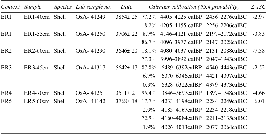
The radiocarbon samples were processed by the University of Oxford Radiocarbon Accelerator Unit using AMS (Accelerator Mass Spectrometry) and calibrated with the OxCal computer program using the IntCal20 dataset. The samples consisted of freshwater shells (see Figs. 7–10), which have been used elsewhere in southern Mesopotamia for dating (e.g., Hritz et al. Reference Hritz, Pournelle and Smith2012). The dating process involved sampling, pretreatment, combustion, graphitisation and AMS measurement (Ramsey et al. Reference Ramsey, Higham and Leach2004). Pre-treatment removed contamination such as sedimentary, organic and dissolved atmospheric carbon dioxide and comprised treatment with phosphoric acid, surface cleaning, drying and crushing (Brock et al. Reference Brock, Higham, Ditchfield and Ramsey2010). Duplicate measurements were performed on some samples to test reproducibility (Ramsey et al. Reference Ramsey, Higham and Leach2004).
The oldest date is situated in the fifth millennium B.C. from ER3 (excavated in system 5/splay 5; see Table 4 and Fig. 9), 4540–4443 calBC. This section was dug where a canal/crevasse splay channel off-takes from the relict channel of the Euphrates. The dates from the other, more distinctly reticulated, canals sampled (ER1 and 2, from System 2) fall into the third millennium B.C. The dates show that the irrigation systems identifiable on satellite images were indeed contemporary with the occupation of Eridu and that the canals represent an early stage of cultivation, in particular ER3. One discrepancy is that the deepest sample from channel section ER1 (Fig. 7) has a more recent date than the shallower sample. Although this could represent later activity, perhaps reuse of the channel, the fill may have been disturbed through bioturbation or perhaps the lower freshwater bivalve collected dug itself especially deep into the channel sediment. The difference in depth between the two samples is only 15 cm. Together the samples from ER1 indicate the channel was collecting fill by the late third millennium B.C. (2146–2455 B.C.).
C14 Dating Results

Table 4: Long description
The table contains radiocarbon dating results for shell samples from various contexts and depths. It has six columns: Context, Sample, Species, Lab sample no., Date, Calendar calibration (95.4 probability), and Δ 13C. The table includes data for five different contexts (ER1 to ER5) with multiple samples from each context. Each row provides details such as the sample identifier, species, lab sample number, date with associated uncertainty, calendar calibration with probabilities, and Δ 13C values. For example, the first row under context ER1 shows a sample from 40 cm depth, identified as OxA-41249, dated to 3854±25 with a calendar calibration of 4405-4225 calBP and 4205-4155 calBP, and a Δ 13C value of -2.97. The table provides a comprehensive overview of the radiocarbon dates and their calibrated ranges for the shell samples collected from different contexts and depths.
Discussion
The oldest radiocarbon date obtained (4540–4443 calBC), from ER3, is in keeping with the earliest phase of irrigation suggested by Wilkinson (Reference Wilkinson2003) and the earliest phase of activity at Eridu, which falls during the Ubaid period. At this location, a canal feature (part of system 5) merges with the trace of a crevasse splay channel (splay 5). The canal appears to abstract from the relict channel of the Euphrates, rather than from the crevasse splay. It represents a rare, very early date for a canal; this may be an example of modification of a crevasse splay to transform it into a canal system, as predicted by Wilkinson (Reference Wilkinson2003) for this period. Our excavation seems to have captured a transitional feature between crevasse splay and canal.
The rest of our dates fall into the third millennium B.C. and encompass more extensive networks of canals (System 2, ER1, ER2) and the relict channel of the Euphrates itself (ER4, ER5). This is the period when more formalised irrigation systems are indicated by archaeological research and cuneiform evidence (Wilkinson Reference Wilkinson2003). Rost discusses third millennium B.C. textual evidence for the administration and division of agricultural areas in the Umma province, which were recorded as around 39 ha (Rost Reference Rost, Michel and Chemla2020: 165). Interpretation of texts dealing with land surveying suggests several different field types, including long narrow strips and also more rectangular features (Lecompte Reference Lecompte, Michel and Chemla2020).
Different shapes of areas enclosed by canals (fields?) are present near Eridu (Fig. 11). The third millennium B.C. dated canal system 2 (from which ER1 and ER2 were taken) takes a gridded form, and it seems that some of the main canals abstract from parts of the crevasse splay (splay 2, for example canal at ER1) and some from the relict Euphrates (e.g., at ER2). The angle at which the offtakes branch from the main canals is nearly perpendicular, rather than acute as in a classic herringbone system, and the fields are squarer. There are some scant traces of more acute-angled herringbone- style canal alignments alongside Eridu (system 1) but we were not able to obtain a date from these. Therefore, it is still not clear if acute-angled herringbone-stye systems represent an earlier form of irrigation to the more gridded style we recorded at system 2 (ER1 and 2). Rost et al. (Reference Rost, Hamdani and George2011) and Wilkinson (Reference Wilkinson2003) suggest that herringbone systems could have been in use in the third millennium B.C., but it has been proposed that some later canals (e.g., Sasanian) also took this form (Wilkinson et al. Reference Wilkinson, Rayne and Jotheri2015). Le Doare et al. (Reference Le Doaré, Mura and Giraud2023) recorded straight line canals in the Uruk-Larsa area, similar in appearance to some of the features we mapped. They also noted the presence of some herringbone structures, similar to the system we mapped nearest Eridu (system 1). Iacobucci et al. (Reference Iacobucci, Troiani, Milli and Nadali2023) mapped canals with herringbone and trellis alignments at Tell Zurghul. Unfortunately, neither study as yet provides scientific dating.
The grid pattern of channels outlines individual farms or palm garden plots, coloured by angle of degree. Satellite image Vision-1 2.7.20 (©Airbus D&S 2021)

Given the difficulty of accessing field sites, many archaeological projects rely solely on remote sensing to map ancient canal systems. Although these data allow a practical bird’s eye view of whole systems, their use is limited without scientific dating evidence. Remote sensing combined with field-based geomorphological analysis is allowing past water management in Iraq to be understood (e.g., Jotheri and Allen Reference Jotheri, Allen, Lawrence, Altaweel and Philip2020). Our study reveals several distinct crevasse splay systems flowing from the former channel of the Euphrates close to Eridu (Fig. 4). Hritz et al. (Reference Hritz, Al-Hawi, Al-Sudani, Albadran, Pournelle, Lawrence, Altaweel and Philip2020) suggest that cultivation in this area would have been sprawls of palm gardens irrigated by crevasse splays. These gardens are represented by a grid pattern of channels (see Figs. 2, 3 and 7). Safar et al.’s excavations recorded the remains of dates and barley (Reference Safar, Mustafa and Lloyd1981), suggesting the kinds of crops the canal systems we have mapped could have supported. The AMS results are mostly consistent with the third–second millennium B.C. and the occupation of the site of Eridu, and the features themselves possibly represent the area of farms which directly fed the city. As Rost suggests, irrigation at this time aimed to deal with controlling flooding as well as water supply (Rost Reference Rost2017), perhaps including attempts to control the flow of water in crevasse splays. Hewett et al.’s series of rainfall models supports the idea that southern Iraq experienced more rain, but also more variable amounts of rain, during the third millennium B.C., followed by a reduced and more consistent amount of rain during the second millennium B.C. (Hewett et al. Reference Hewett, de Gruchy and Lawrence2022).
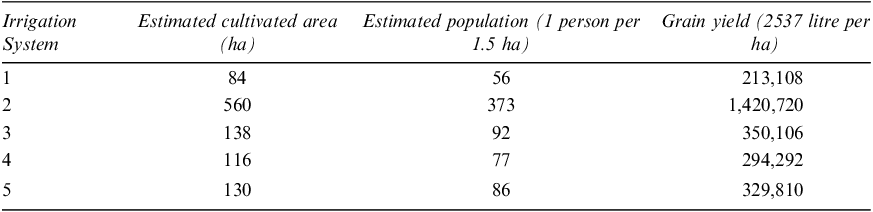
The layout of the digitised channels facilitates tentative estimation of past cultivation. By measuring the visible area encompassed by the extant field systems, the cultivated zone of each system can be calculated (see table 5). Wilkinson (Reference Wilkinson1998: 81), citing Adams (Reference Adams1981: 90), suggests that 1.5 ha land could support c. 1 person. Altaweel (Reference Altaweel, Wilkinson, Gibson, Christiansen and Widell2013: 2) cites sources from third millennium B.C. (c.2400 BC) Girsu indicating grain yields of 2537 litre per ha.
Size of field systems supplied by each irrigation system; population estimate based on 1.5 ha of cultivation supporting 1 person (after Wilkinson Reference Wilkinson1998: 81; Adams Reference Adams1981: 90); grain yield based on Altaweel (Reference Altaweel, Wilkinson, Gibson, Christiansen and Widell2013: 2)

Table 5: Long description
A table with five rows and four columns comparing estimated cultivated areas, populations, and grain yields for different irrigation systems. The columns are labeled 'Irrigation System', 'Estimated cultivated area (ha)', 'Estimated population (1 person per 1.5 ha)', and 'Grain yield (2537 litre per ha)'. Row 1: Irrigation System 1, Estimated cultivated area 84, Estimated population 56, Grain yield 213,108. Row 2: Irrigation System 2, Estimated cultivated area 560, Estimated population 373, Grain yield 1,420,720. Row 3: Irrigation System 3, Estimated cultivated area 138, Estimated population 92, Grain yield 350,106. Row 4: Irrigation System 4, Estimated cultivated area 116, Estimated population 77, Grain yield 294,292. Row 5: Irrigation System 5, Estimated cultivated area 130, Estimated population 86, Grain yield 329,810.
Each system at Eridu supported a larger area than the 39 ha farms at Umma (Rost Reference Rost, Michel and Chemla2020: 165). This may suggest that the irrigation systems supported several small farms each. System 2 could have supported a larger population. This may be an underestimation in each case however, depending on how much of the system remains; system 4 was especially fragmentary.
Our results potentially show cultivation using irrigation from the fifth–first millennium B.C. These data are only snapshots of past activity, but it can be suggested that this area could have been part of a very long-active agricultural zone supporting the city. This example (Table 5) models grain yield, and the data show that the inhabitants of Eridu had access to several types of primary resources from both a large area of fertile, easily irrigatable land and a wide area of marshes. The irrigated land could have provided Eridu with the required wheat, barley, palm trees and other land herbs and vegetables. In contrast, the marshes could have provided Eridu with fish, pigs, water buffalos, reeds, papyrus etc. Phytoliths and diatoms from the region evidence the presence of palm trees from the eleventh millennium B.C., indicating the possibility that they are native to the region, with intensification in the region starting in the late sixth millennium B.C. associated with date palm cultivation (Altaweel et al. Reference Altaweel, Marsh, Jotheri, Hritz, Fleitmann, Rost and Lintner2019).
Detailed hydrological modelling undertaken using our data in the future could give a more nuanced result. The agent-based modelling approach taken by Lang and Ertsen (Reference Lang and Ertsen2023) looks in detail at barley yields in relation to changes in river discharge and gate capacity. One future direction of this study could involve a comparison between these farms mapped from remote sensing and contemporary cuneiform tablets of field plans with measurements, such as those from Umma, but ideally from Eridu itself. Textual evidence from other sites across southern Mesopotamia allows us to guess at the procedures used to manage flow through irrigation systems at Eridu. For example, documents from Ur record flow division structures which allowed water to be easily directed into off-takes (Rost Reference Rost, Michel and Chemla2020: 171).
Ethnographic evidence could also provide insights into how traditional systems can develop and operate. Several crevasse splays have been in use recently in southern Iraq (Iacobucci et al. Reference Iacobucci, Troiani, Milli, Mazzanti, Piacentini, Zocchi and Nadali2020) for growing rice, although many have now disappeared due to modern irrigation projects. Crevasse Splay 2 (Fig. 5) may have been active in the 1960s, based on what can be seen on CORONA images, perhaps with some small canals in the ends of the branches of the crevasse splay in use.
Conclusion
This study addresses a gap in knowledge of the chronology of ancient water management in southern Mesopotamia, providing detailed mapping of the dense networks of channels around the site of Eridu and scientific dating of key sample locations. As predicted by earlier scholars (e.g., Wilkinson), the earliest date (fifth millennium B.C.) was obtained from a feature which seemed to be transitional between crevasse splay and canal (system 5). More clearly reticulated and organised gridded canal systems were dated to the third millennium B.C. and therefore seem to be clearly contemporary with occupation of the site of Eridu itself. The third–second millennium B.C. dates collected from the relict Euphrates are also consistent with the period in which this channel was believed to be active, although it is possible that the first millennium B.C. sample (ER4) is an outlier. These dates from the relict Euphrates may also help to give a terminus ante quem for other irrigation systems deriving from the same relict river course in the wider region.
Our study demonstrates evidence for irrigation from at least the fifth to the third millennium B.C. near Eridu, which aligns with existing narratives for the region (see Altaweel Reference Altaweel2019 for a review). The significance of this study lies in the identification and detailed mapping of the layout of this agricultural system to the level of possible individual fields and the confirmation of this system’s chronological association with the site of Eridu. It can be argued that some of the ancient irrigation systems in Mesopotamia were particularly resilient, based on their longevity. Hritz et al. (Reference Hritz, Al-Hawi, Al-Sudani, Albadran, Pournelle, Lawrence, Altaweel and Philip2020: 260) suggest that this supply of water made possible intensive garden cultivation of dates, which are tolerant of fluctuations in salinity and seasonal water supply. Although the kind of systems we have recorded at Eridu would have needed frequent cleaning, they could potentially have functioned as relatively sustainable, self or locally governed systems (Wilkinson et al. Reference Wilkinson, Rayne and Jotheri2015), facilitating the kind of intensive and resilient cultivation Hritz et al. (Reference Hritz, Al-Hawi, Al-Sudani, Albadran, Pournelle, Lawrence, Altaweel and Philip2020) propose.
It is likely that irrigation in this area was abandoned due to movement of the Euphrates. Understanding how past irrigation systems function in the long term and how environmental challenges were approached in the past could have implications for future sustainability. To achieve this, scholars should continue to prioritise investigating the chronology and trajectory of water management in Mesopotamia using scientific dating approaches. The next phase of this study will include survey of the canals to the south of the relict Euphrates, led by Dr Jotheri (see Jotheri et al. Reference Jotheri, Rokan, Al-Ghanim, Rayne, de Gruchy and Alabdan2025 for mapping). Continued research into ancient irrigation in Iraq using this methodology, which includes comprehensive mapping and sampling for scientific dating evidence, will eventually reveal a detailed picture of the development of water management technology that is still piecemeal and dependent on association with other types of features.
Acknowledgements
We are very grateful for the support of BISI who funded this project. References in support of our project were kindly provided by Dr Maurits Ertsen, Dr Jane Moon, and Dr Sebastien Rey. We would also like to acknowledge the helpful comments of our reviewers. Features were mapped using GIS by Rayne, de Gruchy and Ali Al-Ghanim. Fieldwork was led by Jotheri and assisted by Alabdan and al-Ghanim. Writing and editing was led by Rayne and contributed to by all authors. For Open Access, the authors have applied a Creative Commons Attribution (CC BY) licence to any Author Accepted Manuscript version arising from this submission.








 Open access

