Introduction
Canopy volume is an indicator of growth, health and yield potential in tree crops. It is also used for estimating sparing and fertilizer requirements. The current methods for canopy volume estimation in Brazilian orange groves are quite simplistic. One of the most used considers the tree volume as the volume of a cube enclosing the whole tree. Each side of such a cube is measured manually with a measuring tape. Besides its inaccuracy, the manual method is time consuming and requires a significant number of sampled trees for an adequate representation of the whole grove.
One alternative for the manual method is the ranging sensor (Dworak et al., Reference Dworak, Selbeck and Ehlert2011). Such technology permits not only a higher accuracy on the estimation of canopy geometric parameters but also higher amount of collected data. These data can be georeferenced and acquired throughout the entire field in order to characterize spatial variability. Once spatial variability of canopy volume is known, inputs can be applied in a variable-rate approach according to the tree size variation. Such applications can be carried out at the same time as sensor readings are acquired (i.e in “real time”) (Escolà et al., Reference Escolà, Rosell-Polo, Planas, Gil, Pomar, Camp and Solanelles2013). For these reasons, ranging sensors meet the needs of precision horticulture and represent great potential to enhance management in tree crops.
Two types of ranging sensors are mostly investigated in research, the ultrasonic and the LiDAR sensors. These sensors are usually mounted facing the side of the tree row being able to estimate the distance to the vegetation at different heights along the canopy. LiDAR sensors are considered a better solution than ultrasonic sensors because they are usually more accurate, more rapid, and permit distance measurements in multiple directions from one single sensor.
In the past decade, data acquisition and processing methods were developed based on LiDAR technology aiming at providing 3D models of trees and retrieve canopy volume information (Rosell and Sanz, Reference Rosell-Polo and Sanz2012). Rosell et al. (Reference Rosell-Polo, Llorens, Sanz, Arnó, Ribes-Dasi, Masip, Escolà, Camp, Solanelles, Gràcia, Gil, Val, Planas and Palacín2009) described a mobile terrestrial laser scanner (MTLS) in which raw LiDAR sensor data was transformed into a 3D point cloud representing the laser beam impacts on the canopy. Further works showed how to extract geometric canopy information from 3D point clouds obtained by similar data acquisition systems (Escolà et al., Reference Escolà, Martínez-Casasnovas, Rufat, Arnó, Arbonés, Sebé, Pascual, Gregorio and Rosell-Polo2016). Different methods are available for computing canopy volume from point clouds. Auat Cheein et al. (Reference Auat Cheein, Guivant, Sanz, Escolà, Yandún, Torres-Torriti and Rosell-Polo2015) classified such methods into two main approaches, one referred as the occupancy grid, in which small regular sized objects are created inside the point cloud structure; and another based on connecting the outer points of the point cloud in order to reconstruct the shape of the object formed by the point cloud structure. Both approaches were tested by the authors and were considered viable methods for estimating canopy volume.
Orange groves in Brazil cover approximately 500,000 ha of land (CONAB, 2013). Spray applications are crucial operations in the management of the groves and might occur at least once a month during the cropping season. Spraying recommendations are currently based on manual and poorly accurate measurements of canopy volume. Sensor-based estimation should greatly improve the management of these groves.
The hypothesis of this work is that LiDAR-based methods for canopy geometry estimation should be more accurate than manual methods. However, because different methods and algorithms can be used for processing LiDAR data, different results might be achieved evidencing the need for stablishing new standard methods of canopy volume estimation.
The objective of this work was to compare estimations of orange tree canopy volume by six different methods; two based on traditional manual methods and four based on LiDAR technology using different processing algorithms.
Material and Methods
Data acquisition
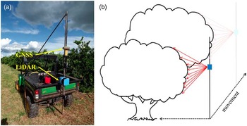
A mobile terrestrial laser scanner was developed based on a 2D LMS 200 LiDAR sensor (Sick, Waldkirch, Germany) and an RTK (Real Time Kinematic) GR3 GNSS receiver (Topcon, Tokyo, Japan). The system was mounted on an ATV vehicle as shown in Figure 1. The LiDAR sensor collected distance values in 181 directions every 13.3 ms (75 Hz) at one-degree angular steps along a vertical plane of the tree canopy. The vehicle moved along the two sides of the tree row at 3.3 m s−1.
LiDAR sensor and GNSS receiver mounted on an ATV vehicle (a); LiDAR sensor (in blue) facing the side of the tree row (b).

A commercial orange grove located in the state of São Paulo, Brazil, was scanned using the developed system. 25 trees inside the grove were selected for this study. The variety of the trees was “Valencia” grafted to “Swingle” rootstock. Trees were six years old at the time of data acquisition (October of 2015).
Data processing
The first step of data processing consisted in creating a georeferenced 3D point cloud representing the laser beam impacts over the canopy. Del-Moral-Martínez et al. (Reference Del-Moral-Martínez, Arnó, Escolà, Sanz, Masip-Vilalta, Company-Mesa and Rosell-Polo2015) give details about this process. The following step is to exclude points that did not represent the target tree canopy (soil and neighboring plants). This step was carried out by visually identifying such points and using tools for selecting and deleting points available in the CloudCompare 2.6.2 software. With the final point cloud from each of the 25 selected trees, the next step was to compute the canopy volume. Two types of surface reconstruction algorithms were applied, the convex-hull and the alpha-shape using the R software packages grDevices and the alphashape3d, respectively. Both algorithms connect the outer points of the cloud in order to produce the surface of the enveloping object. Unlike the convex-hull, the alpha-shape permits the creation of concave objects. The level of concavity is given by setting the index α (lower index results in greater concavities). Three indexes were tested: 0.25, 0.50 and 0.75.
Two types of canopy volume estimation inspired on traditional manual methods were also tested. The first one, which is the most common among Brazilian orange growers, consisted in measuring the volume of a cube that encloses the entire tree. This method is hereafter referred as the cube-fit. The second, referred as the cylinder-fit, considered the canopy volume as two-thirds the volume of a cylinder that encloses the tree. The dimensions of the cube and cylinder were not measured manually as it would be normal. This task usually produces uncertain measurements due to the difficulty of visually defining the limits of the canopy. Besides, it is highly dependent on the person responsible for the task, meaning that usually a systematic error is produced. In order to minimize such errors, the figure dimensions were collected directly from the point cloud using distance-measuring tools available in the CloudCompare 2.6.2 software. Each dimension was given by the average of three measurements.
Results and discussion
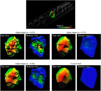
After the LiDAR scanning and the point cloud generation, the average number of points representing each tree was 12,100 distributed into approximately 60 perpendicular transects. The 3D models from the proposed algorithms applied to a single tree are shown in Figure 2. It is noticeable how the convex-hull model apparently produced a larger object, which occurs because salient branches enlarges the hull structure. As expected, concavities of the canopy were better represented by the alpha-shape algorithm. Because this algorithm permits the representation of concave structures, it is reasonable to consider it a suitable model for representing the tree canopy. However, the index α should be appropriately set (not too high neither too low). A low index might produce disconnected structures forming holes inside the canopy, which is not desirable (see alpha-shapes with α set to 0.25 and 0.50 in Figure 2). A guideline for setting α is to choose a value that produces the smallest volume while keeping the canopy as a whole. That result was obtained when α was set to 0.75.
3D canopy structure of a single tree modeled by different algorithms. Top: point cloud section and selected single tree. Middle: Alpha shape models (left, α=0.25; right, α=0.75). Bottom left: Alpha shape model, α=0.50. Bottom right: Convex-hull model.

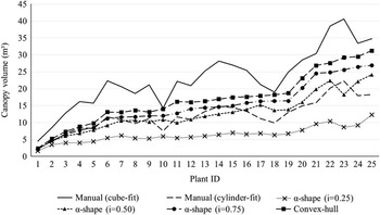
The volumes for each of the 25 individual trees calculated by the proposed algorithms and by the manual methods are showed in Figure 3. The plant IDs were given based on a rank from the smallest to the largest tree according to the alpha-shape (α=0.75) and convex-hull computation. It is to be noticed that this ranking is roughly followed by all the other algorithms. Generally, the manual methods produced a ranking with some disagreement with the other algorithms, which indicated a certain level of randomness in the manual measurements. The rough simplification of the canopy structure by the manual method based on the cube-fit overestimated the canopy volume in relation to all the other algorithms. The measurements from the cylinder-fit method were mainly close to the ones computed with the alpha-shape with index of 0.50.
Canopy volume of 25 individual trees computed by different methods. Plant IDs were given based on a rank from the smallest to the largest tree according to the alpha-shape (α=0.75) and convex-hull computation.

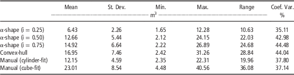
Table 1 shows the descriptive statistics of the measurements of the 25 orange trees. A noticeable difference in all statistical parameters between different computation methods is evident. As expected, the convex-hull model resulted in the highest mean canopy volume among the proposed algorithms, followed by the alpha-shape with higher index α. The volume retrieved from the alpha-shape with α set to 0.25 was significantly smaller than that of other algorithms, due to disconnected structures formed by the model and significant voids inside the canopy, as viewed in Figure 2. On the other end, the cube-fit method resulted in a significantly larger volume than all evaluated methods. Regarding the cylinder-fit, because it considered only two thirds of the cylinder, the final canopy volume is not as large as in the cube-fit method. The cylinder-fit method got closer results to the alpha-shape with index of 0.5, which, as noticed in Figure 1, produced voids inside the 3D model. The differences pointed out between canopy volume estimations indicate the need to adopt some new standard method.
Descriptive statistics of canopy volume of 25 individual trees by different methods

It is also noticeable from Table 1 that the manual methods presented lower coefficient of variation than the 3D modeling algorithms, with exception to the alpha-shape with index 0.25. That might occur because the cube-fit and cylinder-fit represent the tree using less complex figures which are less variable and often do not represent the actual volume of the canopy, i. e., trees with different volume in reality might present similar volumes when these methods are used.
Conclusions
LiDAR-based methods provided more realistic representation of the canopies than current manual methods and should be considered as a new standard for canopy volume estimations.
Important differences among the evaluated methods of canopy volume estimation in orange trees were found. The average canopy volume retrieved by the cube-fit method (the current practice in Brazilian orange groves) was approximately 150% larger than the volume from the alpha-shape with 0.75 index. The alpha-shape modeling with α set to 0.75 was considered an adequate method since it permitted the representation of concave structures of the canopy without creating disconnected objects or voids inside the canopy.
Methods based on cylinder or cube objects were less capable of representing tree size variability than LiDAR-based ones.
Testing more 3D modeling options in a larger amount of sampled trees is still needed. Nevertheless, some guidelines and promising results were presented in this study.