


The emergence of the modern presidency is one of the most important developments in United States history. Prior to the twentieth century, presidents were seen as largely unable to provide strong leadership except in instances of national crisis (Bryce Reference Bryce1888).Footnote 1 Nineteenth-century presidents are commonly regarded as “very ordinary people with very ordinary reputations” (Lowi Reference Lowi1986, 40) whose ambitions were constrained largely by the nature of the party system (Galvin Reference Galvin2014; Klinghard Reference Klinghard2010). Instead, the nineteenth century was “the golden age of the legislature” (Lowi Reference Lowi1986, 30) and the president was merely “the servant of Congress” (Wilson Reference Wilson1885, 213). But as the center of political power transitioned from what Woodrow Wilson (Reference Wilson1885) termed Congressional Government to what Polsby (Reference Polsby1983, 20) labeled the “presidential branch,” the nation entered “an entirely new constitutional epoch” (Lowi Reference Lowi1986, xi), in which modern presidents exert considerably greater influence over the national government’s activities than even Alexander Hamilton may have anticipated.
For all that has been written about the weaknesses of the premodern presidency, however, scholars have assembled little evidence in support of claims about congressional dominance in influencing the goings-on of the federal government. While other research has focused on presidents’ roles in state-building activities and bureaucratic expansion (Carpenter Reference Carpenter2000; Reference Carpenter2001; James Reference James2000; Reference James, Aberbach and Peterson2005; Skowronek Reference Skowronek1982; Whittington and Carpenter Reference Whittington and Carpenter2003), much less is known about the influence of presidents on public policy in earlier time periods. In one of the only such studies, Cohen (Reference Cohen1982) reports that presidents serving in the twentieth century were more successful in achieving the proposals they outlined in their State of the Union addresses than presidents who served in the second half of the nineteenth century. Moreover, recent revisionist scholarship argues that some of the characteristics associated with the modern presidency were in place well before the twentieth century (Bailey Reference Bailey2007; Cohen Reference Cohen2012; Galvin and Shogun Reference Galvin and Shogan2004; Klinghard Reference Klinghard2005; Reference Klinghard2010), raising the intriguing possibility that earlier presidents were more influential than commonly recognized.
In this article, I argue that presidents who served prior to the modern era benefited in their dealings with Congress from their position as head of the executive branch. Scholarship on nineteenth-century bureaucracies details the ways in which administrative officials gained autonomy from their political principals and developed valuable reputations and expertise (Carpenter Reference Carpenter2001; Gailmard and Patty Reference Gailmard and Patty2012), and these informational advantages cumulated to the president by generating patterns of congressional deference. Though previous literature recognizes that nineteenth-century bureaucracies served as important conduits of information, scholarship on Congress and the presidency has not previously acknowledged how this expertise systematically advantaged the president.
Understanding the scope of nineteenth-century presidential influence has important consequences for scholarship on interbranch relations, bureaucratic politics, and American political development more generally. First, presidential power is widely believed to have been at its nadir in the post-Reconstruction period, and the relative weakness of pre-twentieth century presidents is a key assumption of the modern presidency paradigm. Second, studies of the distribution of particularistic goods such as post offices, rural delivery routes, and rivers and harbors legislation typically focus on the roles of Congress (Kernell and McDonald Reference Kernell and McDonald1999; Wilson Reference Wilson1986) and the bureaucracy (Carpenter Reference Carpenter2000, Reference Carpenter2001) to the exclusion of the president. Moreover, the account offered here helps clarify the political incentives that contributed to bureaucratic growth and generated distinct patterns of state-building. Fourth, this article contributes to recent efforts to more fully incorporate both Congress (Katznelson and Lapinski Reference Katznelson and Lapinski2006; Lapinski Reference Lapinski2008) and quantitative methods (Wawro and Katznelson Reference Wawro and Katznelson2014) with the study of American political development.
Building on research that investigates presidential influence over the distribution of federal resources in the contemporary period (Berry, Burden, and Howell Reference Berry, Burden and Howell2010; Kriner and Reeves Reference Kriner and Reeves2015), I examine the relative influence of presidents and congressional majority parties over the expansion of the national post office in the late nineteenth century. Using an original dataset of the county-level distribution of post offices from 1876 to 1896, I find strong and consistent evidence of presidential influence over the provision of post office locations. Counties represented by a president’s copartisans received significantly more post offices than other counties, and these advantages were especially large under divided government and in electorally important states. The results are robust across a wide range of model specifications, empirical strategies, and when examining the Senate. The findings reported here suggest that premodern presidents directed the activities of the federal government to a larger degree than is commonly recognized and raise new questions about the links between the modern presidency and presidential influence.
POLITICAL INFLUENCE AND THE PRE-MODERN PRESIDENCY
Concerns about the proper distribution of power across the legislative and executive branches of government have animated discussions about American politics dating back to the Articles of Confederation. As Madison wrote in Federalist 51, “In republican government, the legislative branch necessarily predominates.” Scholars widely agree, however, that since at least the New Deal era the U.S. has witnessed the ascendence of the modern presidency (Cohen Reference Cohen1982; Lowi Reference Lowi1972; Reference Lowi1986; Moe Reference Moe, Chubb and Peterson1985; Neustadt Reference Neustadt1990), and modern presidents possess many levers of influence that were not available to their predecessors (e.g., Moe and Howell Reference Moe and Howell1999).
The breadth of presidential influence over lawmaking and the administrative state in earlier periods is much less clear. As the title of Woodrow Wilson’s (Reference Wilson1885) dissertation attests, American politics in the nineteenth-century was dominated by Congressional Government. In the years following the Civil War, rising incumbency rates, the centralization of power by party leaders, and vigorous electoral competition helped to institutionalize the House of Representatives in particular (Polsby Reference Polsby1968). In an apt summary of the conventional wisdom, Lowi (Reference Lowi1972, 201) wrote: “The ‘Republican Era’ of 1869-1901 is generally thought of as a period of congressional dominance.”
Congress was thought to dominate during this time period, moreover, because independent presidential leadership was weak or altogether nonexistent. As De Santis (Reference de Santis1963, 556) argued, “National political power was then vested chiefly in Congress and not in the presidency.” The late nineteenth-century presidency was said to have been weakened by the turbulent tenure of Andrew Johnson (White Reference White1958) and constrained by Whig commitments to the presidency’s limited constitutional role and responsibilities (Skowronek Reference Skowronek1993, 52).Footnote 2 As Lowi (Reference Lowi1972, 301) pointedly observed, “The only thing Presidents were strong about was their faith in the separation of powers, which meant steadfast passivity in the policy-making process.”
Congressional dominance in the nineteenth century plays an important role in the modern presidency paradigm. In Constitutional Government Wilson (Reference Wilson1908) articulated a new vision of the American political order that placed the president squarely at the center, and Lowi (Reference Lowi1986, vii) described the realization of this vision as the founding of a “Second Republic.” Reflecting on these developments, proponents of the modern presidency thesis argued that “the transformation of the office has been so profound that the modern presidencies have more in common with one another in the opportunities they provide and the demands they place on their incumbents than they have with the entire sweep of traditional presidencies from Washington’s to Hoover’s” (Greenstein Reference Greenstein1982, 3). However, a range of scholars have questioned the merits of such a bifurcacted periodization, arguing instead that many elements of the modern presidency appeared far earlier in history than generally acknowledged (Adler Reference Adler2013; Cohen Reference Cohen2012; Ellis and Walker Reference Ellis and Walker2007; Galvin and Shogan Reference Galvin and Shogan2004; Klinghard Reference Klinghard2005; Reference Korzi2010; Korzi Reference Korzi2004; Laracey Reference Laracey2002; Young Reference Young2011) and calling for a reconceptualization of the links between the historical and contemporary presidency (Skowronek Reference Skowronek1993; Reference Skowronek2002).
Scholars from Leonard White (Reference White1958) to Scott James (Reference James2000) have argued that traditional accounts underestimate the capacity for policy leadership by Gilded Age presidents. For instance, presidents during this era controlled patronage appointments, which enabled even the weakest presidents to successfully advance the party agenda (Whittington and Carpenter Reference Whittington and Carpenter2003). Bryce (Reference Bryce1888, vol. 1, 61) recognized the potential for patronage appointments to exalt presidential influence: “The president’s patronage is, in the hands of a skilful intriguer, an engine of far-spreading potency. By it he can oblige a vast number of persons, can bind their interests to his own, can fill important places with the men of his choice.” Though appointments were heavily influenced by party politics, a president’s ability to mete out appointments to advantage his party likely would have been an important indicator of a president’s success (Rogowski Reference Rogowski2015).
In addition to patronage authority, presidents oversaw a rapidly growing administrative state. Though bureaucracies during this period were much smaller than modern bureaucracies, presidents could appoint like-minded officials to carry out their wishes where discretion was delegated to the executive branch. Prior to the centralization of the budgetary process, moreover, the appropriations process was generally understood to provide Congress with little capacity for oversight over agency activities and expenditures (White Reference White1958). This lack of oversight over agency expenditures thus provided opportunities for bureaucratic officials to privilege the president’s priorities. Thus, despite a sizable literature’s insistence that “congressional dominance” characterized interbranch relations during the era of premodern presidents, presidents were hardly complicit in ensuring their subservience, and instead possessed tools that may have advantaged them vis-à-vis Congress.
I subject the congressional dominance thesis to empirical scrutiny and evaluate the relative influence of presidents and Congress in the context of the Post Office Department and the distribution of federal post offices.Footnote 3 While other research on the distribution of federal resources in the contemporary era generally focuses on federal grant expenditures (e.g., Berry, Burden, and Howell Reference Berry, Burden and Howell2010; Christenson, Kriner, and Reeves Reference Christenson, Kriner and Reeves2014; Dynes and Huber Reference Dynes and Huber2015; Kriner and Reeves Reference Kriner and Reeves2015; Levitt and Snyder Reference Levitt and Snyder1995; Mebane and Wawro Reference Mebane and Wawro2002; Stein and Bickers Reference Stein and Bickers1995), the distribution of post offices provides a direct measure of federal commitments and investment in public goods. As previous scholars have long recognized, however, presidential influence is difficult—if not impossible—to observe directly.Footnote 4 Instead, I study one set of observable implications that stem from the relative balance of influence across the branches of government, and examine whether a president’s copartisans in Congress, rather than members of the congressional majority party, were disproportionate recipients of post office locations in the late nineteenth century. In doing so, I distinguish between the provision of benefits to a president’s copartisans under unified government (in which case one cannot infer whether the president or the majority party is most influential) and divided government (in which case evidence of presidential influence suggests the ability to overcome the majority party in Congress). Examining how distributive benefits accrue to legislators sheds light on how the institutional arrangements during the premodern presidency affected political outcomes.
POLITICAL CONTROL OF THE POST OFFICE
The post office enjoys a privileged position in the story of the nineteenth-century American state. According to Leonard White (Reference White1958, 258), “The Post Office was unique in the closeness of its relations to the great mass of people.” The post office was “the only state organization that interacted with all citizens” (Carpenter Reference Carpenter2001, 66) and was “one of the most important institutions of the day” (John Reference John1995, vii).
Control over the provision of post offices was formally shared between the executive and legislative branches. Article I, Section 8 of the U.S. Constitution granted Congress the power “to establish Post Offices and post Roads,” and the Post Office Act of 1792 established that Congress had the sole power to designate post offices and establish postal routes. Congressional reins over post offices were loosened, however, with the Postal Act of 1825, in which Congress granted the Postmaster General the authority to “establish post offices, and appoint postmasters, at all such places as shall appear to him expedient, on the post roads that are, or may be established by law,” though Congress retained its exclusive authority over designating postal routes. In practice, these arrangements formally split control over the establishment of post offices between Congress and the executive branch, as post office locations could be established only when they could be served by an existing postal road.Footnote 5
Though the nineteenth-century Post Office Department was among the largest and most costly departments in the late nineteenth century—by 1895 its appropriations accounted for 18 percent of the domestic federal budget—in other ways it resembled many of the other bureaucracies. During this period, executive branch agencies were relatively amorphous structures and did not often have established protocols or routines (Blevins Reference Blevins2014). For instance, confusion over responsibility for post office decisions was reflected in whom citizens lobbied from the establishment of a post offices, as petitions submitted by local communities requesting new post offices were variously addressed to the Postmaster General, their member of Congress, members of the Post Roads and Post Offices committee, and the president himself.Footnote 6 These conditions made it especially difficult for Congress to exert much direct political control over nineteenth-century bureaucracies. Due to the sizable discretion afforded to the Postmaster General, this position was among the most powerful of the president’s cabinet officials.
Communities across the country mobilized around the establishment of post offices. For instance, in 1894, the New York Times reported on the “strenuous efforts” made by the Asbury Park, New Jersey Board of Trade “to obtain additional facilities for handling the increased business of the local Post Office.”Footnote 7 In 1884, local residents of Gresham, Oregon petitioned the government for a post office, and proposed renaming the city (then variously called Powell Valley and Camp Ground) after Postmaster General Walter Gresham if the post office request were granted.Footnote 8 Presidents themselves also took notice. As President Hayes wrote in his farewell message to Congress in December 1880: “All the inhabitants of the country are directly and personally interested in having proper mail facilities, and naturally watch the post office very closely. This careful oversight on the part of the people has proved a constant stimulus to improvement.”Footnote 9
Politics played a key role in the expansion of the post office. As Fuller (Reference Fuller2003, xi) writes, “No arm of the national government. . .was as closely connected to American politics or subject to more pressures from various interest groups.” Post offices were needed and distributed throughout every corner of the nation. This fact was not lost on political leaders. An article that appeared in the St. Louis Post-Dispatch on May 25, 1886 noted that “Post-office fights are among the most disagreeable subjects [House] members encounter in their careers,” and speculated that Rep. Albert Willis of Kentucky “will have a hard fight for renomination on account of his decision in the Louisville Post-office case.”Footnote 10 Presidents also were frequently involved in postal affairs. President Grover Cleveland’s assistant, George F. Parker, noted (Reference Parker1909, 266) that the president spent inordinate amounts of time meeting with prospective postmasters and regularly exercised his veto pen over post office appropriations—even for relatively minor sums. Thus, postal affairs consumed considerable attention from both members of Congress and the president.
Though providing post offices may have been an important component of political responsiveness to local communities, the patronage opportunities made available through the post office were a far more important commodity for presidents and Congress.Footnote 11 Debates over the establishment of post offices nearly exactly reflected Gailmard and Patty’s (Reference Gailmard and Patty2012, 98) observation that “Reconstruction-era politics. . .[revolved] around the struggle between Congress and the president for control of patronage.” According to Carpenter (Reference Carpenter2001, 66), these appointments were made “far less for service than for electoral fidelity.” The Postmaster General’s office reached out to congressional representatives from the relevant area to serve as “referees” on a given postmaster appointment, though this courtesy was extended far more frequently to a president’s copartisans (Cushing Reference Cushing1893; Fowler Reference Fowler1945).
DISTRIBUTIVE POLITICS AND THE POST OFFICE
Despite the relatively weak (by contemporary standards) bureaucratic structures that characterized the late nineteenth century, informational asymmetries between Congress and the executive branch were likely to advantage the president. Innovations undertaken by bureaucratic offices during this time period significantly increased the department’s expertise in a wide range of matters, including the demand for and performance of local post office locations. Executive branch expertise can advantage the president (e.g., Howell, Jackman, and Rogowski Reference Howell, Jackman and Rogowski2013, chap. 2), in large part due to the tendency of Congress to defer to bureaucratic experts (e.g., Carpenter Reference Carpenter2001; Gailmard and Patty Reference Gailmard and Patty2012).
Appointment prerogatives and bureaucratic expertise were likely to benefit the president (and his constituencies) across a wide range of domains. Mashaw’s study of administrative law during the late nineteenth century notes (Reference Mashaw2010, 1463) that “The president retained the power to appoint. . .and regained the removal power—a power than had been transformed into a presumptive power to direct administrative action.” For instance, control over military and civilian appointments generated considerable lobbying of executive branch officials during the Spanish-American war.Footnote 12 Beyond appointments, military pensions provided to veterans and their families operated as a relatively pure form of distributive good. These pensions consumed 34 percent of the federal budget by 1894 (Keller Reference Keller1977, 311–2), and Skocpol (Reference Skocpol1993) reports that pension officials often attended to pension requests based on the importance of the recipient’s state in the upcoming presidential election. Bureaucratic expertise was cultivated across the federal bureaucracy, including in the Patent Office, Department of Agriculture, and the Pension Office (Carpenter Reference Carpenter2001; White Reference White1958).Footnote 13 Thus, the conditions for presidential influence appeared to be in place for many domains of American government during this time period.
The postal inspector system was a key source of the post office’s informational advantages.Footnote 14 The inspectors traveled to local offices throughout the country, checking accounts, investigating claims of fraud, and helping to introduce greater efficiency into the mail system. Due to their travels, the inspectors “provided to Washington officials a previously unavailable view of local operations” such that they “became the informational glue of the department” (Carpenter Reference Carpenter2001, 109). For the purposes of establishing new locations, moreover, the postal inspectors were unrivaled in their knowledge of where post offices were most needed and how these decisions would be received. As Carpenter (Reference Carpenter2001, 109) explains:
When local offices were eliminated, when one community (and not another) was chosen for free delivery, when routes were changed or service terminated for a time, communities expressed varying levels of dissatisfaction. The department maintained an ongoing calculus of the political costs and benefits of these actions, even if the moves were administratively minute. What the special agents brought to the equation, again, was information. The department could propose the elimination of a delivery route or a local office, and the agents could provide an estimation of the local reaction.
Through bureaucratic structures like the postal inspectors, therefore, the executive branch secured important informational advantages that it could use to generate congressional complicity.
Perhaps reflecting these informational asymmetries, Congress appeared quite deferential to Post Office Department officials. For instance, on February 25, 1882, Congress passed a law that provided the Postmaster General with the authority to allow his subordinates to issue warrants for payments from the U.S. Treasury for postal operations. When it came to post office expansion, Post Office and Post Roads committees in the House and Senate “favored the wishes of postal officials, particularly when experimental results warranted it” (Carpenter Reference Carpenter2001, 95). Perhaps most importantly, Congress made little use of its key institutional advantage vis-à-vis the executive branch: appropriations power. Rather than using detailed line-item appropriations to control bureaucratic activity, Congress frequently allocated lump sums with respect to some of the largest items of expenditure (Mashaw Reference Mashaw2010). For instance, total post office appropriations for fiscal year 1895 summed to $87,236,599.55 spread over 41 line-items, most of which were extremely vague and allowed the Postmaster General and his staff to determine how funds were to be spent.Footnote 15 Though Congress had the capacity to make specific provisions for at least some forms of particularistic goods such as rivers and harbors, Congress appeared to do so relatively infrequently in the case of the post office.
Congressional deference to the Post Office Department was likely to privilege the president and, through the president’s role as de facto party leader (James Reference James2000, Reference James, Aberbach and Peterson2005), his congressional copartisans.Footnote 16 The president’s copartisans represent potential supporters of the president, and presidents stand to gain when their congressional copartisans are recognized by their constituents for providing valuable federal resources. Because the time period under investigation largely precedes the introduction of the Australian ballot, the electoral fates of presidents and their copartisans in Congress were linked especially tightly.
The hypothesis outlined here contrasts with the expectations offered by canonical theories of distributive politics that focus on how members of Congress secure resources for their constituencies. Universalistic theories argue that legislators engage in logrolling, and thereby secure benefits for their constituents by supporting other legislators’ claims to similar resources (Shepsle and Weingast Reference Shepsle and Weingast1987; Weingast Reference Weingast1979), and thus each legislator secures a roughly equal share of the federal pie for his constituents. Other theories emphasize the relative success of well-positioned legislators in securing distributive benefits for their constituents, such as those serving on key committees including Appropriations, Ways and Means, and, in the case of post offices, the Post Office and Post Roads committees, and committee chairs or ranking members may be especially well-positioned to secure additional distributive benefits (Deering and Smith Reference Deering and Smith1997; Ferejohn Reference Ferejohn1974; Shepsle and Weingast Reference Shepsle and Weingast1987). Alternatively, Congress may disproportionate rewards to majority party members. Because majority parties seek to cultivate a favorable view of the party “brand” among voters, their control of the agenda may enable them to funnel federal resources to the constituencies their members represent (Cox and McCubbins Reference Cox and McCubbins2005). The empirical tests that follow assess these hypotheses directly.
DATA
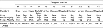
I test the congressional dominance thesis using an original dataset of county-level post offices in the late nineteenth century. The data were collected from the United States Official Postal Guide, which was published annually from 1874 to 1954 and contained information about the organization of the department, postal rates, changes to postal regulations, the names and salaries of postmasters appointed by the president, and a complete list of the locations of post offices by county and state. These data were collected for even years between 1876 and 1896.Footnote 17 The advent of rural free delivery in 1896 altered the need for continued post office expansion, and thus 1896 is a sensible endpoint for the analysis.Footnote 18 The number of post offices in the data nearly doubled over the time period under investigation, from 35,650 in 1876 to 69,116 by 1896.
Across the entire time period, the average number of post offices per county was just over 20, and the median county had 16. However, post offices do not appear to have been distributed uniformly across the country or within states. While each county had at least one post office, a number of counties had well over 100. The concentration of post offices was greatest in the northeast, and over this time period the number of post offices expanded dramatically across the South and West. While differences in the allocation of post offices were correlated with county population, population alone did not fully explain the distribution of post offices. For instance, though the two most populous counties in 1896, New York (1.8 million) and Cook (1.6 million) counties, had similar populations, the number of post offices differed considerably. New York County had 59 post offices, up from 42 in 1894, while Cook County had 225 post offices, which had increased from 174 just two years earlier. The variation across counties suggests that the distribution of post offices could have been influenced by political factors, and thus bears a close similarity to other research that investigates the distribution of federal spending on “high-variation” programs (Berry, Burden, and Howell Reference Berry, Burden and Howell2010; Kriner and Reeves Reference Kriner and Reeves2015; Levitt and Snyder Reference Levitt and Snyder1995; Stein and Bickers Reference Stein and Bickers1995).
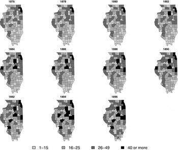
Figure 1 below shows how the number of post offices increased in Illinois from 1876 to 1896. Darker shades indicate greater numbers of post offices. In 1876, for instance, only Cook County—home of Chicago—had 40 or more post offices, while 46 counties had 15 or fewer. By 1886, three additional counties (Hancock, LaSalle, and McLean) had 40 or more post offices, and the number of counties with 15 or fewer post offices had reduced to 32. And by 1896, counties in the state’s northeastern and southwestern industrial areas had been blanketed with new post offices.
The Expansion of the Post Office in Illinois, 1876–1896

The use of counties as the units of analysis confers several advantages. Perhaps most critically, with counties I avoid geographic challenges associated with congressional redistricting. For instance, Ohio’s congressional lines were redrawn seven times between 1878 and 1892 (Taylor Reference Taylor1899). The use of congressional districts would only allow the analysis to take advantage of changes in political factors that occurred within a single redistricting cycle. Thus, because county lines are fixed and relatively stable across time, the analysis exploits all available changes in political alignments to identify their effects.
At the same time, this analysis − like virtually any analysis of congressional political geography during this time period − confronts unavoidable issues related to the overlap between counties and congressional districts. Two sets of counties are excluded from the analyses that follow. Most obviously, I excluded counties that are split across districts. Distributing these counties’ post offices across congressional districts is not straightforward; fortunately, however, only 1.3 percent of counties over this time period were shared by more than one congressional district. I also dropped counties in states with multiple congressional seats and used at-large districts exclusively, which applies mostly to South Dakota and Washington and represents another 1.6 percent of the counties during this time period.
Empirical Strategy
Based on the panel nature of the data, I use a differences-in-differences design to identify the effects of the political factors discussed above on the distribution of post offices. This approach isolates the effects of political affiliation on the provision of post offices while accounting for other time-invariant characteristics of counties, both observed and unobserved, that also influence the distribution of post offices. Specifically, I estimate the following model:
 $$\begin{eqnarray}
\mbox{ln}(\mbox{post offices}_{it}) = \beta _0 + \alpha _i + \delta _t + \beta _1 M_{it} + \beta _2 C_{it}\nonumber\\
&& +\, \beta _3 P_{it} + {\bf X} \Omega _{it} + \epsilon _{it},
\end{eqnarray}$$
where i and t index counties and years, respectively. Because the distribution of post offices is highly skewed, I use its logged value as the dependent variable.Footnote 19 The three key variables are indicators for the partisan alignment of the legislator with the House majority party and the president. Members of Congress who shared the president’s party and were also members of the House majority party are indicated by Mit ; members of the majority party who did not share the president’s party are indicated with Cit ; and legislators who shared the president’s party and were members of the House minority party are indicated by Pit . Thus, legislators who are members of the minority party and do not share the president’s partisanship are the omitted category. The coefficients that accompany these variables, β1 through β3, are the main parameters of interest. Positive values of these parameter estimates indicate that the associated variable increased the number of post offices in a given county. The key comparison is between the estimates associated with Cit and Pit . If presidents were more influential than congressional majority parties in directing post offices to their copartisans, then we would expect the coefficient for β3 to be larger in magnitude than the coefficient for β2. The congressional dominance hypothesis, in contrast, predicts that β2 is positive and significantly greater than the estimate of β3. The model also includes county fixed effects (α i ) to control for all observed and unobserved time-invariant county attributes that may affect the distribution of post offices, and time fixed effects (δ t ) to account for changes in the distribution of post offices across time. I also include a matrix (X it ) of other county, legislator, and contextual characteristics that may also be related to the distribution of post offices, which are explained below in greater detail. Finally, β0 is a constant term, Ω it is a vector of coefficients for the control variables, and ε it is a random error term, clustered on state.Footnote 20
The model represented by Equation (1) identifies the key parameters of interest using within-county changes in the alignment between the county’s congressional representative, the House majority party, and the president’s party. These changes can occur in two general ways. First, the county could be represented by a new legislator or a new president could take office. Second, majority control of the House could switch. The time period under investigation provides nearly ideal conditions for producing both kinds of variation. More than two-fifths (41.5 percent) of the members of Congress elected during this time period were elected to their first term, and another 26.3 percent had served one term or only a portion of a term, implying that turnover produced frequent changes in a county’s congressional representative. Moreover, only one president (Cleveland) served more than one term, no president was re-elected in successive elections, and the partisan affiliation of the president changed in three of the four president elections that occurred during the period. Party control of the House switched five times. Of the ten congresses that met between 1877 and 1896, party control of the House and the presidency was divided in six; Democrats held control of both the House and the presidency in three congresses, and Republicans had unified control in two. These frequent changes in the occupancy of the White House and Congress ensure a great deal of variation for identifying the key coefficients. Table 1 below summarizes these configurations and details the number of post office locations contained in the data.
Presidential Terms, Partisan Control of Government, and the Distribution of Post Offices (1876–1896)

Of course, the distribution of post offices was also explained by other, potentially confounding, factors. Thus, I estimated models with a broad set of control variables. First, more populous counties were likely to have more post offices, so I include the logged value of county population in all models. Second, because densely populated areas would have needed more post offices than rural areas, I also include a measure of population density, measured by hundreds of people per square mile. Third, some members of Congress may be better-positioned than others to deliver post offices to the counties in their districts. Thus, I include indicators for whether members served on the Ways and Means, Appropriations, and the Post Office and Post Roads committees.Footnote 21 As previous work on distributive politics has found (Berry, Burden, and Howell Reference Berry, Burden and Howell2010), there may also be partisan differences in the provision of post offices; thus, I include an indicator for counties represented by a Democrat.
The electoral environment and the member’s experience may also have affected the provision of post offices. For instance, presidents and their administrations may have strategically targeted states in which they narrowly won or lost election; thus, I include an indicator (Close presidential election) for whether a county is located in a state in which the margin of victory was five percentage points or less in the most recent presidential election. Similar dynamics may have affected legislators’ incentives to secure post offices, and thus I include an indicator (Marginal district) for whether the legislator’s margin of victory in the most recent congressional election was five percentage points or less.Footnote 22 Moreover, inexperienced legislators may be less effective at securing distributive benefits for their districts; thus, I include an indicator for counties represented by a first-term member of Congress.
Following Dynes and Huber (Reference Dynes and Huber2015), I also estimate models in which I distinguish the provision of post offices due to the partisanship of elected officials from the partisanship of the electorate.Footnote 23 Thus, I include a term President aligned with county, which interacts the indicator for being represented by a member of the president’s party with the district’s underlying partisan disposition.Footnote 24 Positive (negative) values indicate counties that were more (less) Republican than the average county. If presidential administrations attempt to deliver benefits to their copartisan constituencies, then the coefficient associated with President aligned with county should be positive. I construct an analogous variable that measures MC aligned with county and uses the county-level congressional election vote share.
RESULTS
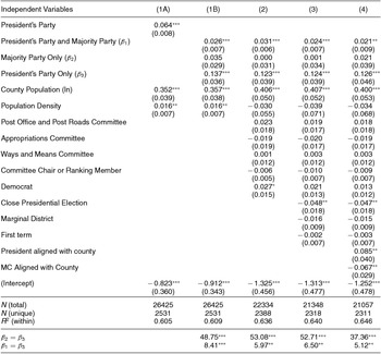
Table 2 below shows the results of the fixed effects regression analyses described above. I first estimated a reduced version of Equation (1), in which I simply regressed the logged number of post offices on an indicator for whether counties were represented by a legislator from the president’s party, along with county population (logged) and population density. Column (1A) displays the coefficient estimates and accompanying standard errors. The results of this rather simple model suggest that being represented by a member of the president’s party conferred clear benefits. On average, counties represented by a president’s copartisans received about 6 percent more post offices than counties not represented by a member of the president’s party. These results provide preliminary evidence, then, that the president’s legislative copartisans received disproportionate shares of distributive benefits.
Explaining the Distribution of Post Offices, 1876–1896

Notes: Entries are linear regression coefficients and standard errors, clustered by state. The dependent variable is the number of post offices per county (logged). County and year fixed effects were estimated but not reported. The last two rows report F statistics from Wald tests for the equality of the coefficients associated with the partisan affiliation of a county’s congressional representative.
*** Indicates p < 0.01; ** indicates p < 0.05; * indicates p < 0.10 (all two-tailed tests).
Column (1B) displays results using the full set of indicators for the partisan alignment of a county’s legislator, along with the population and population density variables. All three indicators are positive, indicating that counties represented by members of the House majority party and/or the president’s party received more post offices than counties represented by minority party members not aligned with the president, though their magnitudes vary. The coefficient for President’s party and majority party (β1) indicates that members of the president’s party under unified government received 2 to 3 percent more post offices, while the coefficient for President’s party only (β3) indicates that members of the president’s party under divided government received a considerably larger increase in post offices (13.7 percent). The coefficient for Majority party only (β2) is positive (0.035), but not statistically significant. Formal comparisons of β2 and β3 (shown in the bottom panel of the table) further reveal that the coefficient for President’s party only is statistically distinguishable from the coefficient for Majority party only. Moveover, while counties represented by a president’s copartisans received additional post offices compared to counties represented by members of the minority party not aligned with the president, this increase was significantly larger when the president’s copartisans were the minority party in the House.
The results from more fully specified regression models provide strong and consistent support for the findings from the model shown in column (1B). For instance, in model (2), I included indicators for whether legislators served on one of the key appropriations committees (Post Office and Post Roads, Appropriations, or Ways and Means), or served as a committee chair or ranking member, and their partisanship. Model (3) contains indicators for whether the margin of victory in the most recent presidential and congressional elections was five percentage points or smaller, and whether the county was represented by a first term legislator. Model (4) includes the measures of constituency partisanship in presidential and congressional elections, as suggested by Dynes and Huber (Reference Dynes and Huber2015). Across all these additional specifications, being represented by a presidential copartisan is associated with a statistically significant increase (between 12 and 13 percent) in post offices compared to being represented by a member of the minority party under unified government. Importantly, the coefficient for President’s party only is always substantially larger in magnitude than and statistically distinguishable from the coefficient for Majority party only.
The recovered coefficients for the control variables are also of interest for understanding distributive politics during the late nineteenth century. First, the coefficient for county population is consistently between 0.35 and 0.41. As the discussion above highlighted, this result implies that the provision of post offices did not perfectly correspond with growing populations, but rather increased at a rate about two-fifths the rate of population increase. The coefficient estimates for population density are somewhat inconsistent across the various models. In the simple model (1B), the coefficient is positive and statistically significant, but is negative and not distinguishable from zero in models 2 through 4.
None of the models provides evidence that members of the relevant committees secured greater resources. The coefficient for membership on the Post Office and Post Roads Committee is consistently positive, between 0.021 and 0.023, yet is not statistically different from zero. One potential explanation is that the Post Office and Post Roads committee was relatively small, ranging from 9 to 14 members during this time period, and represented approximately 3 percent of the counties in the data set. Thus, there may simply be too few observations to reliably estimate the effect of committee membership. The coefficient associated with Appropriations committee membership is consistently negative, while the coefficients for Ways and Means membership include zeroes in the first two places to the right of the decimal. Furthermore, I find no evidence that serving as a committee chair or a ranking member is associated with increased numbers of post offices. In addition, while there is suggestive evidence that counties represented by Democratic members of Congress received more post offices than counties represented by Republicans, the coefficient is statistically significant only for model 2.
The results also provide limited evidence that post offices were strategically allocated to more electorally competitive environments. The coefficient for Close presidential election is consistently negative and statistically significant, indicating that counties in states with close presidential elections actually received fewer post offices. Because states tended to be consistently competitive (or not) during the entire time period studied here, this negative coefficient may result from changes in electoral competitiveness in just a handful of states. There also is no evidence that marginal congressional districts are associated with increased numbers of post offices; the coefficient is consistently negative and small in magnitude. Additionally, first-term members of Congress appeared to be no less successful than more experienced legislators in securing post offices for the counties in their districts.
Finally, as the coefficients in column (4) show, consistent results are obtained when accounting for constituency partisanship. The coefficient for President aligned with county suggest that counties who supported the president and are represented by a presidential copartisan received larger shares of post offices. However, I find no evidence that majority party members of Congress directed increased numbers of post offices to counties that provided them with higher levels of support; in fact, the coefficient indicates a negative relationship.
The results above are suggestive of strategies presidents may have used to advantage his congressional copartisans. The entries in the bottom row of Table 2 show that the president’s copartisans were significantly more advantaged under divided government (when they were in the minority party) than under unified government. These results are generally consistent with insights from a model of presidential influence over distributive policy (McCarty Reference McCarty2000), in which presidents direct benefits toward favored constituencies such that the benefits accumulate at greater rates as the president’s constituency size reduces. As Table 1 shows, overall increases in post offices did not appear to vary with instances of unified and divided government; given this rather fixed budget, increases in the number of presidential copartisans would decrease the average difference between the benefits received by his constituency and members of the opposite party.Footnote 25 In supplementary analyses, I test this proposition more directly by interacting the indicators for partisan alignment with the proportion of House seats held by the legislator’s party, and the results provide further support for this explanation.Footnote 26
Alternative Dependent Variable
The analyses above provide strong support for the role of presidential copartisans in securing post offices for their constituents. To address the possibility that members of Congress were more concerned with maximizing increases in resources between one Congress and the next, I estimated models where the dependent variable is the change in the number of post offices between Congress t - 1 and Congress t. On average, the number of post offices increased by 1, though nearly ten percent of counties experienced an increase of 5 or more post offices.
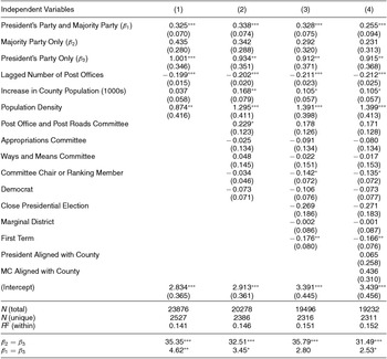
The results are shown below in Table 3.Footnote 27 Across all four models, the results again show that being represented by a presidential copartisan conferred significantly larger increases in the provision of post offices comapred with being represented by a member of the majority party.Footnote 28 The other substantive conclusions from Table 2 remain unchanged with the exception of counties represented by first term members of Congress, where the increase in post offices was significantly smaller compared to counties represented by more experienced legislators. Thus, in combination with the results from Table 2, the findings in Table 3 show that not only did counties receive more post offices when they were represented by a presidential copartisan, but the number of post offices in those counties also increased at higher rates.
Explaining Increases in the Distribution of Post Offices, 1876–1896

Notes: Entries are linear regression coefficients and standard errors, clustered by state. The dependent variable is the increase in the number of post offices in county i between year t and t − 1. County and year fixed effects were estimated but not reported. The last two rows report F statistics from Wald tests for the equality of the coefficients associated with the partisan affiliation of a county’s congressional representative.
*** Indicates p < 0.01; ** indicates p < 0.05; * indicates p < 0.10 (all two-tailed tests).
Robustness Checks
The results shown in Tables 2 and 3 are robust to several other alternative models and subsets of observations. First, all post offices were not the same. Some post offices were large, grand facilities that served many thousands of people and offered the opportunity for large numbers of patronage positions. The vast majority, however, were simple fourth class post offices stationed in rural locations. Thus, to examine the possibility that the results above are confounded by differences in the kinds of post offices awarded to different localities, I estimated the models shown in Table 2 focusing just on the distribution of these fourth class post offices. The results are strongly consistent with those shown above.Footnote 29
Second, the results presented above are also robust to accounting for within-legislator changes in the alignment of presidential copartisanship and affiliation with the majority party. I re-estimated the models shown above using legislator fixed effects in which the coefficients for President’s party and majority party, Majority party only, and President’s party only are identified using within-member changes in partisan control of the presidency and the House.Footnote 30 These results once again indicate that counties represented by presidential copartisans, particularly under divided government, received substantially more post offices than other legislators.Footnote 31
Third, though the differences-in-differences design accounts for time-invariant county characteristics, several time-varying characteristics may also confound the relationship between political factors and the distribution of post offices. Because the country changed rapidly over this time period, I included controls for the percentage of the county population that lived in urban areas, and the illiteracy rates in counties.Footnote 32 Though these county characteristics are significantly associated with the distribution of post offices (the provision of post offices was lower in counties with higher illiteracy rates and more urban populations), the substantive patterns shown in Table 2 remain unchanged.
Fourth, the results are not sensitive to the exclusion of the South (defined as the 11 states of the confederacy). After Reconstruction, both Republican and Democratic presidents prioritized expanding the administrative state in the South, thus raising questions about whether these efforts are responsible for the findings reported above. While I find that the rate of post office expansion was greater in the South than it was in other regions of the country, models that exclude the South generate results consistent with those shown in Tables 2 and 3.
Finally, the results shown above do not appear to be driven by any particular president or year. I re-estimated model (4) shown in Table 2 one at a time while dropping observations associated with each of the presidential administrations and years. The coefficient for President’s party only is statistically significant in each of these models, and the magnitude of the coefficient ranges from 0.087 to 0.158. In each instance it is statistically larger in magnitude than the coefficient for Majority party only. While the president’s copartisans could have benefited more during some presidential administrations than in others, the patterns shown here do not appear to be attributable to the idiosyncracies of any particular president or Congress.
Thus, across a wide range of model specifications, dependent variables, subsets of counties and presidential administrations, and modeling strategies, I find strong, consistent, and robust evidence that counties represented by legislators who shared the president’s party received substantially more post offices. At the same time, the results provide limited or no evidence that counties represented by members of the House majority party, key committees, or who served as committee chairs or ranking members received increased numbers of post offices.
Recipients of Presidential Targeting
Presidents may have had incentives to target some constituencies more than others, even within their own parties. Some of these decisions may have been predicated upon electoral goals. As the nominal heads of their party, presidents have incentives both to maximize their party’s opportunity to win the next presidential election as well as reward constituencies that provide reliable bases of support.Footnote 33 In addition, presidents may have targeted resources toward key members of Congress. For instance, post offices (and the attendant patronage jobs) could have been used to secure votes from or reward support from key members of Congress.
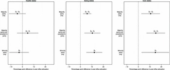
I investigated how the distribution of post offices interacted with the president’s partisan goals by distinguishing counties based on the electoral context of their states. Due to both the Electoral College and the decentralized nature of the party system in the late nineteenth century, presidents may have had incentives to privilege certain states over others in awarding post offices. Thus, I estimated models in which I interacted the indicator for the partisan alignment between a county’s congressional representative and the president based on the state’s electoral context. Following Kriner and Reeves (Reference Kriner and Reeves2015), I characterized swing states as those where the previous presidential election was decided by 10 percentage points or less, and core states as those where the president won by more than 10 percentage points. The omitted category, hostile states, indicates counties in states where the president lost by more than 10 percentage points. I re-estimated the model shown in column (4) of Table 2, and interacted the indicators for the partisan alignment of a county’s congressional representative with the indicators for state electoral context.
Figure 2 below graphically displays the results.Footnote 34 Each plot depicts the relative advantages in the distribution of post offices enjoyed by counties represented by the president’s copartisans under divided government. The plotted points shows the percentage point difference between the number of post offices awarded to counties represented by a presidential copartisan in divided government, and the number of post offices awarded to counties represented by legislators with different partisan alignments. Counties in hostile states do not stand to receive systematically larger numbers of post offices based on the partisan alignment of their congressional representative. Under divided government, presidential copartisans appear to receive fewer post offices than members of the majority party, yet this coefficient estimate is not distinguishable from zero. None of the other coefficient estimates are distinguishable from zero, either. Thus, counties in states that strongly opposed the president do not stand to gain additional post offices on the basis of the partisan alignment of the legislator who represents them. Counties in both Swing and Core states, however, benefitted substantially when represented by a member of the president’s party. For instance, in swing states, counties represented by the president’s party under divided government received 5.9 percent more post offices than counties represented by the minority party under divided government. In core states, the advantage was even larger, at 10.7 percentage points.Footnote 35 Counties represented by presidential copartisans in divided government also fared considerably better than counties in both swing and core states under unified government when those counties were represented by either majority or minority party members. On the whole, therefore, presidential influence in the distribution of federal post offices was felt most strongly in states that were most important to the president and his party.
Electoral Context and Presidential Targeting, 1876–1896

I also explored whether post offices were targeted to particular members of Congress. For instance, presidents may have used resources such as post offices to enhance the electoral prospects of their copartisans, in which they would have had the strongest incentives to direct post offices toward their copartisans in marginal districts. Presidents could also used vote-buying strategies in which they used post offices to secure legislative support from members of the opposite party, in which case presidents may have targeted more moderate legislators from the other party whose support would be “cheapest” to obtain. The results of these supplementary analyses do not provide convincing evidence in support of either of these potential explanations; in fact, somewhat surprisingly, the results indicate that presidential copartisans in marginal districts received fewer post offices compared to the president’s copartisans who won election by larger margins.Footnote 36 It is possible, however, that the relatively short time span and small number of congresses studied here limits the ability to more systematically study how these political characteristics interacted with the partisan alignment between legislators and the president.
Evaluating the Patronage Mechanism: Senate Results
Though prior research on distributive politics has focused almost exclusively on the role of the House, the account offered here regarding the president’s role in directing resources to his copartisans applies just as well to the Senate. Here I extend the empirical results offered above to the U.S. Senate over the same time period. Beyond offering a robustness check on the House results, analyzing the Senate allows me to study the patronage mechanism more directly. In comparison with members of the House, who may have desired post office locations for electoral purposes, Senators were chosen by state legislatures during this time period to serve the interests of the state parties. Thus, Senators would have strong incentives to procure post offices during this time period specifically for the purposes of securing valuable patronage positions. To conduct this analysis, I aggregate post office and population data at the state level.
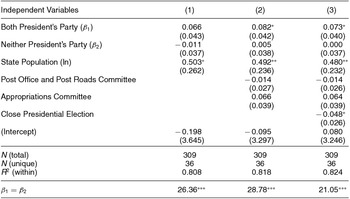
At the outset, though, I acknowledge that analyzing the Senate introduces several empirical challenges. Most critically, because each state is served by two senators, I cannot isolate the effect of partisan alignments between an individual senator, the majority party, and the president. Instead, I estimate models with two indicators that reflect the partisan composition of a state’s Senate delegation with respect to the president. Specifically, I include an indicator for whether both senators from state i in congress t were members of the president’s party, and an additional indicator for whether neither senator belonged to the president’s party. Thus, split delegations are the omitted category. As in Table 2, the dependent variable is the logged number of post offices and standard errors are clustered on states. I also include state and year fixed effects.
The results are shown below in Table 4. Column (1) displays the estimates from a simple model with the indicators for the state’s Senate partisan alignment and population. The coefficient for Both president’s party is positive and indicates that states served by two members of the president’s party received a 6.6 percent increase in post offices relative to states with split delegations, though the coefficient falls shy of conventional levels of statistical significance (p = 0.13). The coefficient for Neither president’s party, however, is negative (though also not distinguishable from zero), suggesting that states represented by two senators from the party opposite the president fared worse than states with split delegations. Importantly, this coefficient is statistically distinguishable (p < 0.001) from the coefficient for Both president’s party. In column (2), however, I include indicators for whether at least one senator served on the Post Office and Post Roads and Appropriations committees. Column (3) adds an indicator for whether the previous presidential election was decided by 5 percentage points or less. Across these latter two models, the coefficient for Both president’s party is positive, larger in magnitude, and statistically significant. The coefficient for Neither president’s party, however, is extremely small and not distinguishable from zero.
Senate Delegations and the Distribution of Post Offices, 1876–1896

Notes: Entries are linear regression coefficients and standard errors. The dependent variable is the number of post offices per state (logged). State and year fixed effects were estimated but not reported. The last row reports F statistics from Wald tests for the equality of the coefficients associated with the partisan affiliation of a state’s Senate delegation.
*** Indicates p < 0.01; ** indicates p < 0.05; * indicates p < 0.10 (all two-tailed tests).
On the whole, the results provide evidence that the partisan alignment between the president and a state’s senate delegation had importance consequences for the distribution of post office locations. Consistent with the results from the House analysis, states that were represented by a unified bloc of the president’s copartisans received more post offices than either states represented by a split delegation or whose senators both were members of the opposition party. I continue to find no evidence that committee membership was a significant predictor of the distribution of post offices, while states with close presidential elections received fewer post offices. Finally, the Senate analysis offers a useful check to ensure that the county-level analyses for the U.S. House were not an artifact of a particular level of analysis or aggregation.
CONCLUSION
Conventional wisdom dictates that modern presidents exercise a measure of influence over the goings-on of government that eluded presidents in earlier eras. Though Andrew Jackson, James K. Polk, and Abraham Lincoln are often acknowledged as exceptionally strong nineteenth-century presidents, policymaking in the nineteenth century is said to have been marked by congressional dominance. The subservience of both presidents and bureaucratic officials to Congress led Woodrow Wilson (Reference Wilson1885, 177) to declare that “In so far as the President is an executive officer he is the servant of Congress; and the members of the Cabinet, being confined to executive functions, are altogether the servants of Congress.”
This article provides clear evidence that bureaucratic policymaking in the Gilded Age systematically advantaged the president’s congressional copartisans. Counties represented by members of the president’s party received substantially more post offices, and the advantages conferred to presidential copartisans were significantly greater under divided government. The findings reported here suggest that presidents played substantially greater roles during this period in directing the activities of the federal government than scholars have typically acknowledged.
The results revise common understandings about the roles of presidents and Congress in expanding the federal administrative state. In contrast with accounts that emphasize congressional leadership over initiatives such as rural free delivery (Kernell and McDonald Reference Kernell and McDonald1999), this article documents the influence of the president over the expansion of the post office. This conclusion nicely extends Carpenter’s (Reference Carpenter2000, Reference Carpenter2001) argument that bureaucratic innovation was spurred by executive branch politics, and complements James’s (Reference James2006, 59) contention that “patronage discipline [was] systematically applied to service the electoral welfare of the president’s party” during the post-Reconstruction era. Identifying the incentives for political officials to engage in such behavior—such as how and when members of Congress and the president received electoral benefits from federal resources such as post offices—is an important topic for future research.
This article provides systematic empirical evidence in support of a growing chorus of research that raises questions about the utility of the modern presidency paradigm (Adler Reference Adler2013; Cohen Reference Cohen2012; Ellis and Walker Reference Ellis and Walker2007; Galvin and Shogan Reference Galvin and Shogan2004; Klinghard Reference Klinghard2010; Korzi Reference Korzi2004; Laracey Reference Laracey2002; Skowronek Reference Skowronek1992; Reference Skowronek1993; Reference Skowronek2002; Young Reference Young2011). While the challenges facing the country in the wake of two world wars and the Great Depression may have indeed exalted presidential power, the evidence suggests that the divide between premodern and modern presidencies may not be as dramatic or as deep as scholarship on the presidency indicates. Indeed, many of the key institutional advantages afforded modern presidents—including the ability to influence agency behavior—were also available to presidents in earlier eras, though perhaps to different degrees.
Several central theoretical implications follow. First, research on the presidency and the separation of powers should make more explicit the institutional changes that facilitated greater presidential influence during the modern presidency. Though recent work by Cohen (Reference Cohen2012) takes an important step in this direction, additional theoretical and empirical work is needed to trace and explain the development of presidential influence within the separation of powers. Second, presidents may have played a greater role in the construction of the bureaucracy than generally acknowledged; for instance, in directing where the federal postal system expanded, presidents helped shape the trajectory of this key bureaucratic institution. As Moe (Reference Moe1987) argued, explaining bureaucratic activity requires looking beyond the halls of Congress and instead focusing on the larger institutional environment.
A few important caveats apply. First, though the theoretical discussion posited that the president’s copartisans were likely advantaged due to congressional deference to Post Office Department expertise, the data do not allow me to evaluate this mechanism systematically. Gailmard and Patty (Reference Gailmard and Patty2012) highlight several examples of variation in expertise across nineteenth-century bureaucracies, and future research could further explore the implications of this variation for presidential influence over policy. Second, and related to this point, while the findings in this article indicate that presidents played a significant role in directing the locations of post offices, the theoretical logic outlined in this article suggests that appointment prerogatives and expertise served as key levers of presidential influence more generally in periods that preceded what scholars have termed the modern presidency. Indeed, ownership of property rights over appointments and bureaucratic expertise was not confined simply to the Post Office Department, and thus presidents were likely able to exert substantial influence in the conduct of government affairs in other domains as well, including matters related to war, military pensions, and the Departments of Agriculture and Interior. However, identifying the degree of (and limits to) presidential influence over other forms of policymaking and governmental activity, across historical periods and through various mechanisms, remains an important task in the study of political institutions and American political development.
SUPPLEMENTARY MATERIAL
To view supplementary material for this article, please visit http://dx.doi.org/10.1017/S0003055416000125




Comments
No Comments have been published for this article.