


The rate and style of contemporary ice sheet retreat relates to a number of globally important scientific and socio-economic questions (IPCC Reference Stocker2013). Mapping and dating ice-sheet retreat, both past and present, improves our understanding of how large ice masses dynamically respond to internal and external forcing, such as glaciological, climatic and sea level perturbations. In turn, this information can be used to better predict how present-day ice sheets will respond under future different climatic and sea level scenarios. The former British–Irish Ice Sheet (BIIS) during the last glacial cycle provides a relatively small but geospatially well constrained example of a mid-latitude marine-influenced ice sheet, which at its maximum was around one third the size of the present-day West Antarctic Ice Sheet, or approximately equivalent to ∼2 m of eustatic (global) sea level change (Hubbard et al. Reference Hubbard, Bradwell, Golledge, Hall, Patton, Sugden, Cooper and Stoker2009; Gibbard & Clark Reference Gibbard and Clark2011; Clark et al. Reference Clark, Hughes, Greenwood, Jordan and Sejrup2012).
Although well studied, with over 100 years of literature on the topic, the geometry of the BIIS and its deglaciation pattern in certain key sectors between the Last Glacial Maximum (LGM: ca. 25–30 ka BP) and Greenland Stadial 1 (13–11.5 ka BP) are still uncertain (e.g. Sutherland Reference Sutherland1984; Gordon & Sutherland Reference Gordon and Sutherland1993; Evans et al. Reference Evans, Clark and Mitchell2005; Chiverrell & Thomas Reference Chiverrell and Thomas2010). An insight into the distribution and complexity of the Quaternary stratigraphic succession on the continental shelf to the north and west of Scotland, as well as tentative ice limits, was established in the early 1990s as part of the BGS regional offshore mapping programme of the UK Continental Shelf (Fyfe et al. Reference Fyfe, Long and Evans1993; Stoker et al. Reference Stoker, Hitchen and Graham1993). The resultant stratigraphic framework was based upon a combination of geophysical data (seismic-reflection profiles), geological boreholes and shallow core material. The recent acquisition of seabed imagery – combined with the legacy geophysical and geological datasets – has shed important new light on the offshore extent and general retreat pattern of the ice sheet, especially in its northern and western sectors (Bradwell et al. Reference Bradwell, Stoker, Golledge, Wilson, Merritt, Long, Everest, Hestvik, Stevenson, Hubbard, Finlayson and Mathers2008a; Dunlop et al. Reference Dunlop, Shannon, McCabe, Quinn and Doyle2010; Stoker & Varming Reference Stoker, Varming, Ritchie, Ziska, Johnson and Evans2011; Ó Cofaigh et al. Reference Ó Cofaigh, Dunlop and Benetti2012; Howe et al. Reference Howe, Dove, Bradwell and Gaferia2012; Stoker Reference Stoker, Hitchen, Johnson and Gatliff2013). Collation of the pre-existing landform evidence (Clark et al. Reference Clark, Evans, Khatwa, Bradwell, Jordan, Marsh, Mitchell and Bateman2004) and dating constraints (Hughes et al. Reference Hughes, Greenwood and Clark2011) with new bedform mapping across the British (Hughes et al. Reference Hughes, Clark and Jordan2010) and Irish (Greenwood & Clark Reference Greenwood and Clark2009) landmasses, and the offshore landform evidence (Bradwell et al. Reference Bradwell, Stoker, Golledge, Wilson, Merritt, Long, Everest, Hestvik, Stevenson, Hubbard, Finlayson and Mathers2008a), as well as some additional mapping, allowed Clark et al. (Reference Clark, Hughes, Greenwood, Jordan and Sejrup2012) to produce an empirically based ice-sheet-wide reconstruction, with time slices showing key stages of retreat. Their work is currently the best available synthesis of the geomorphological evidence relating to the last BIIS, but is still only a generalised picture owing to the low-resolution and variable coverage quality of the offshore datasets used.
In this paper, we present a refinement of this picture for the NW sector. We use recently acquired marine geophysical data, in the form of both single-beam and multibeam echo sounder, alongside legacy seismic sub-bottom profiles, to map in detail the 3-D shape, distribution and internal character of seabed features relating to the ice sheet that once covered northern Scotland. The seabed glacial geomorphology is described and then interpreted – using geomorphological principles, established landsystem models and reference to other published geological data – to reconstruct a detailed and glaciologically plausible pattern of ice sheet retreat from the continental shelf edge to the Scottish mainland. The resulting pattern differs from previous mapping, including the interpretations presented by Bradwell et al. (Reference Bradwell, Stoker, Golledge, Wilson, Merritt, Long, Everest, Hestvik, Stevenson, Hubbard, Finlayson and Mathers2008a) and Clark et al. (Reference Clark, Hughes, Greenwood, Jordan and Sejrup2012), and opens up questions about the style and retreat dynamics of deglaciation around northern Scotland and, by implication, the palaeo-glaciology and palaeo-environment of the wider region.
1. Study area
1.1. Geographical extent
We focus on an area of the UK continental shelf around northern Scotland, where bathymetric data coverage is exceptionally good and the Pleistocene seabed geomorphology is remarkably well preserved. Specifically, the area comprises all the continental shelf within a box 310 km N–S by 330 km E–W, approximately centred on 59°N, 5°W (Fig. 1).
Extent of the study area in the northern UK, showing general topography and bathymetry around northern Scotland. Bathymetry coloured to emphasise depth variations on the continental shelf; water depths off the continental shelf (>200 m) are not shown. Bathymetric features in italic font; islands and headlands in roman font.
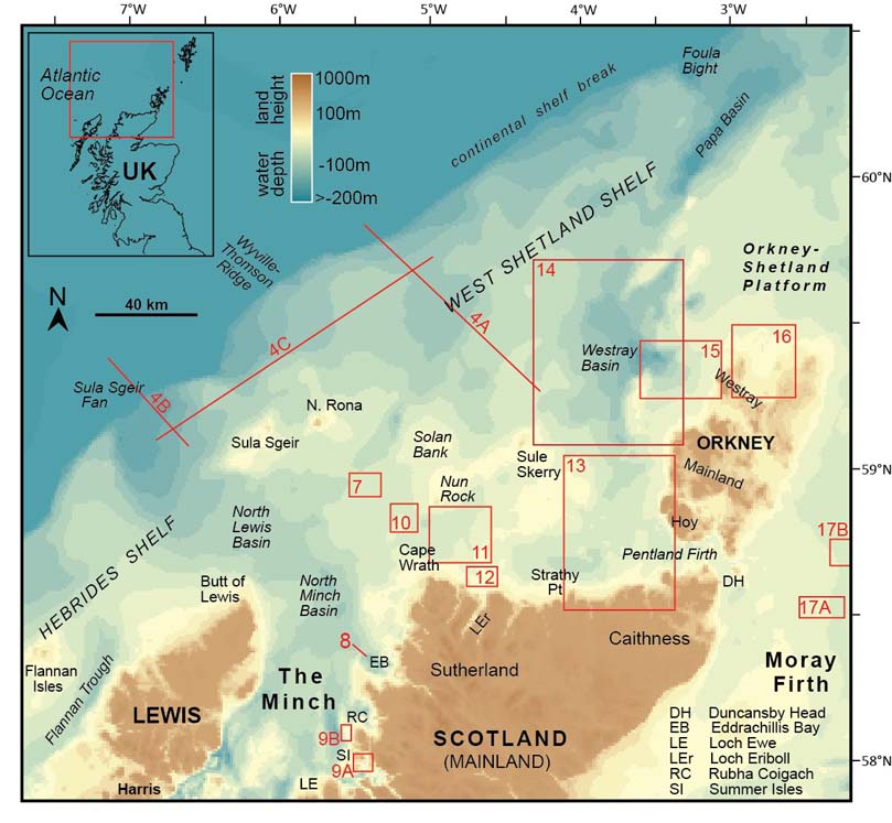
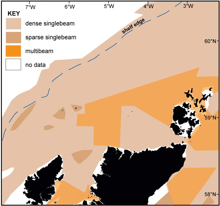
The westward extent of the continental shelf is defined by the shelf break, in this study approximated by the present-day 200 m water depth contour. The study area also includes part of the mainland of Scotland, north of Loch Ewe, as well as the islands of Orkney, Lewis and the small outlying islands and rocks of North Rona, Sula Sgeir and Sule Skerry – although no onshore data has been analysed in this study. The total area of continental shelf seabed within the study is ca. 55,000 km2, of which >90 % is covered by single-beam bathymetry data and ∼45 % is covered by recently acquired high-resolution multibeam data (Fig. 2).
Echo sounder bathymetry data coverage on the UK continental shelf within the study area (as of December 2013). Both single-beam and multibeam data sets were used in this work. Single-beam echo sounder data are part of a global dataset managed and compiled by Olex AS (Norway) and licensed for scientific research. Multibeam echo sounder data were primarily collected by the Maritime and Coastguard Agency between 2005 and 2011 and form part of ongoing UK Hydrographic Office surveys in UK waters.
1.2. Quaternary geology and glacial history
The Quaternary deposits and stratigraphy of the NW UK continental shelf are complex and difficult to correlate across the whole region, largely owing to their irregular and patchy nature, and the lack of well dated units. Stoker et al. (Reference Stoker, Hitchen and Graham1993) summarised the Quaternary succession on the Hebrides and West Shetland shelves based on numerous seismic reflection profiles, geological boreholes and other marine geophysical data collected by the BGS between the late 1960s and 1990 (Fig. 3). The regional development of the Quaternary succession presented by Stoker et al. (Reference Stoker, Hitchen and Graham1993) has since been updated and summarised for both the Hebrides (Stoker Reference Stoker, Hitchen, Johnson and Gatliff2013) and West Shetland (Stoker & Varming Reference Stoker, Varming, Ritchie, Ziska, Johnson and Evans2011) regions, and work continues in order to rationalise the Quaternary stratigraphy (Stoker et al. Reference Stoker, Balson, Long and Tappin2011a, Reference Stoker, McMillan and Watersb) as a basis to providing stratigraphic and geological context for seabed geomorphological mapping studies and palaeo-environmental (palaeo-glaciological) reconstructions.
(A) Distribution of Quaternary formations on the NW UK Continental shelf, determined from seismostratigraphy and seabed cores (modified from Stoker et al. Reference Stoker, Hitchen and Graham1993). Where the Quaternary succession is thin, patchy or cannot be resolved in seismic profiles, it remains undifferentiated; this results in some artificial boundaries. Inset maps show (B) available marine geophysical data and (C) seabed cores, on which these original interpretations were made. Black lines are single-channel seismic profiles, mostly collected by the British Geological Survey between 1970 and 1990. Green dots are existing BGS boreholes (variable depth penetration, typically 20–300 m); orange dots are BGS vibrocores (max. 6 m penetration).

Generally speaking, the Plio–Pleistocene deposits on the Hebrides Shelf, north of the Outer Hebrides, are thinner and less common than on shelf areas further south (e.g., the Malin Shelf) and in the North Sea sector. Seismic profiles from the northern Hebrides Shelf show an irregular glacial unconformity, with over-deepened basins, cut into Mesozoic and Cenozoic strata, punctuated by locally upstanding remnants of Pre-Cambrian basement rocks (e.g. Sula Sgeir High). It is in the deeper basins where locally thick accumulations of Pleistocene sediments are preserved. Seismic records and boreholes identify subglacial, ice contact (morainic) and proglacial (outwash) sediments overlain by glaciomarine sediments within the main depocentres – the North Minch and North Lewis basins – where the Quaternary sequence exceeds 100 m in places (Fyfe et al. Reference Fyfe, Long and Evans1993; Stoker et al. Reference Stoker, Hitchen and Graham1993; Stoker Reference Stoker, Hitchen, Johnson and Gatliff2013). These two large broad basins demarcate a wide bathymetric pathway, or cross-shelf trough, which terminates on the continental slope, where in excess of 200 m of Middle–Upper Pleistocene glacially-influenced sediments have accumulated on the Sula Sgeir Fan (Stoker Reference Stoker, Scrutton, Stoker, Shimmield and Tudhope1995) (Figs. 1, 4). The location of this trough-mouth fan, in association with numerous diagnostic geomorphological criteria onshore and offshore, led to the identification of a palaeo-ice stream in this sector of the British–Irish ice sheet (Stoker & Bradwell Reference Stoker and Bradwell2005; Bradwell et al. Reference Bradwell, Stoker and Larter2007). It is thought that the Minch ice stream was a quasi-stable glaciological feature draining ca. 10,000–15,000 km2 of the BIIS via a convergent system of fast-flowing tributaries (Bradwell et al. Reference Bradwell, Stoker and Larter2007; Bradwell Reference Bradwell2013); and was periodically active over the last 0.5 million years (Stoker & Bradwell Reference Stoker and Bradwell2005; Stoker Reference Stoker, Hitchen, Johnson and Gatliff2013)
Quaternary stratigraphy of (A) the West Shetland Shelf and (B) the Hebrides Shelf, derived from seismic profiles (from Stoker et al. Reference Stoker, Hitchen and Graham1993). (C) Schematic showing stratigraphic relationship between Pleistocene units on the mid-outer shelf, highlighting their angular discordance. See Figure 1 for lines of section.

Further north, the West Shetland Shelf has a Quaternary sediment architecture and glacial history generally similar to that of the Hebrides Shelf further south (Stoker Reference Stoker, Scrutton, Stoker, Shimmield and Tudhope1995; Stoker & Varming Reference Stoker, Varming, Ritchie, Ziska, Johnson and Evans2011). However, the mid-shelf is characterised by a number of thick partially overlapping diamicton-dominated sediment sequences forming moraine banks 30–50 m high and 3–6 km wide. Acoustically well-layered ponded sediments, proved in cores to be glaciomarine sandy muds, occur between the ridges. These large submarine moraines (or morainal banks), preserved on the seabed, are interpreted to mark sequential still-stands or ice-front oscillations during overall southeastward retreat of the ice sheet across the shelf (Stoker & Holmes Reference Stoker and Holmes1991; Bradwell et al. Reference Bradwell, Stoker, Golledge, Wilson, Merritt, Long, Everest, Hestvik, Stevenson, Hubbard, Finlayson and Mathers2008a). Micropalaeontological data from shallow cores in the uppermost glacial diamicton suggest deposition in water depths of less than 50 m (Stoker et al. Reference Stoker, Hitchen and Graham1993; Stoker & Varming Reference Stoker, Varming, Ritchie, Ziska, Johnson and Evans2011). The whole moraine complex, termed the Otter Bank Formation (Figs 3, 4), has been shown from seismostratigraphic correlations to be Late Weichselian (=Late Devensian) in age, although the sediments themselves remain undated (Stoker & Holmes Reference Stoker and Holmes1991). Importantly, this moraine system is clearly visible on the single-beam bathymetry NW of Orkney. The outer shelf and slope are characterised by a thick wedge of Plio–Pleistocene sediments with prograding and aggrading geometries. The uppermost semi-continuous ice-proximal debris-flow-dominated deposit forms the Rona and Foula Wedges – interpreted as large coalescent glacigenic sediment fans fed by an ice sheet margin reaching the shelf edge west of Orkney and Shetland (Stoker Reference Stoker, Scrutton, Stoker, Shimmield and Tudhope1995; Davison Reference Davison2005; Stoker & Varming Reference Stoker, Varming, Ritchie, Ziska, Johnson and Evans2011).
Close to the shelf edge, adjacent to the Sula Sgeir Fan, large broad sediment ridges with iceberg-scoured surfaces have been mapped from seismic data as submarine moraine banks (Stoker Reference Stoker, Dowdeswell and Scourse1990, Reference Stoker, Hitchen, Johnson and Gatliff2013; Stoker & Holmes Reference Stoker and Holmes1991) and stratigraphically defined as the MacDonald Formation (Stoker et al. Reference Stoker, Hitchen and Graham1993, Reference Stoker, Balson, Long and Tappin2011a). The largest of these MacDonald Formation moraines occurs at the shelf edge in present-day water depths of ∼200 m; it is a 20–30 m high ridge, up to 4 km wide with low angle slopes, and extending laterally for 50 km. BGS seismic profiles show an acoustically structureless unit makes up the bulk of the ridge, probably a glacial diamicton, although the ice-distal slope interdigitates with gently dipping acoustically layered units comprising the glacigenic slope apron on the upper Sula Sgeir Fan (Stoker Reference Stoker, Dowdeswell and Scourse1990, Reference Stoker, Scrutton, Stoker, Shimmield and Tudhope1995, Reference Stoker, Hitchen, Johnson and Gatliff2013; Stoker et al. Reference Stoker, Hitchen and Graham1993) (Fig. 4). The overall geometry and seismic character of the largest Macdonald Formation Moraine is similar to subaqueous grounding zone features (wedges and morainal banks) seen elsewhere in glaciated shelf settings (e.g. Shaw et al. Reference Shaw, Piper, Fader, King, Todd, Bell, Batterson and Liverman2006; Dowdeswell et al. Reference Dowdeswell, Ottesen, Evans, Ó Cofaigh and Anderson2008; Rydningen et al. Reference Rydningen, Vorren, Laberg and Kolstad2013). This large moraine is also visible in single-beam echo sounder bathymetry data. The MacDonald Formation moraines were taken as evidence of widespread glaciation on the Hebrides Shelf during the Late Pleistocene (Stoker & Holmes Reference Stoker and Holmes1991; Stoker et al. Reference Stoker, Hitchen and Graham1993, Reference Stoker, Leslie, Scott, Briden, Hine, Harland, Wilkinson, Evans and Ardus1994). However, a more precise age and their relationship with seabed moraines to the north and south remain unclear, though seismic-stratigraphic evidence indicates that their deposition pre-dates the moraines of the Otter Bank Formation, which rest with angular discordance on the MacDonald Formation (Stoker & Holmes Reference Stoker and Holmes1991; Stoker et al. Reference Stoker, Hitchen and Graham1993). Despite this stratigraphic discordance, subsequent large-scale shelf-wide seabed geomorphological mapping and the resulting reconstructions have tentatively correlated these Outer Hebrides Shelf moraines with others on outer West Shetland Shelf, ∼150 km to the NE (Bradwell et al. Reference Bradwell, Stoker, Golledge, Wilson, Merritt, Long, Everest, Hestvik, Stevenson, Hubbard, Finlayson and Mathers2008a; Chiverrell & Thomas Reference Chiverrell and Thomas2010; Clark et al. Reference Clark, Hughes, Greenwood, Jordan and Sejrup2012). Clearly, on the basis of seabed imagery alone, the stratigraphic and chronological basis for these correlations remains ambiguous.
1.3. Sea level history
Whether or not the last British–Irish ice sheet had large marine sectors, grounded below sea level, during deglaciation is currently a topic of key interest (cf. Clark et al. Reference Clark, Hughes, Greenwood, Jordan and Sejrup2012; Chiverrell et al. Reference Chiverrell, Thrasher, Thomas, Lang, Scourse, van Landeghem, Mccarroll, Clark, Ó Cofaigh, Evans and Ballantyne2013; Finlayson et al. Reference Finlayson, Fabel, Bradwell and Sugden2014); one which impacts strongly on the style and dynamics of ice sheet retreat (e.g., Alley et al. Reference Alley, Clark, Huybrechts and Joughin2005; Schoof Reference Schoof2012). At the time of Last Glacial Maximum, when Scotland was covered by a Late Weichselian ice sheet, global eustatic sea level was around 110–130 m below present (Lambeck Reference Lambeck1991, Reference Lambeck1993; Peltier & Fairbanks Reference Peltier and Fairbanks2006). The relative sea level picture at this time offshore western Scotland was complex and is not well constrained on the NW continental shelf, but would have varied with distance from the main area of isostatic depression (Lambeck Reference Lambeck1993; Gordon & Sutherland Reference Gordon and Sutherland1993). The apparent absence of raised marine (MIS 2) shorelines in the Outer Hebrides (Dawson Reference Dawson1984) indicates that sea levels were probably lower than today at ice-free times during much of the last glacial cycle. Numerical glacial rebound models predict that the Isle of Lewis and the adjacent Hebrides Shelf have experienced relative sea levels below that of the present day since c. 16 ka BP, and probably since the global sea level minima (∼26 ka BP) (Lambeck Reference Lambeck1991, Reference Lambeck1993; Milne et al. Reference Milne, Shennan, Youngs, Waugh, Teferle, Bingley, Bassett, Cuthbert-Brown and Bradley2006). Northern hemisphere ice sheet deglaciation produced rapidly rising eustatic sea levels between ∼14–8 ka BP; however, there is no evidence for raised sea levels in the Outer Hebrides even during the Holocene, suggesting that local crustal isostatic depression was great enough to more than offset eustatic sea level changes in the peripheries of NW Scotland. A similar setting is envisaged in Shetland, where no raised shorelines have been identified (Sissons Reference Sissons, Smith and Dawson1987) and relative sea levels are thought to have risen continuously (if not smoothly) from deglaciation to the present day (Lambeck Reference Lambeck1991; Shennan et al. Reference Shennan, Bradley, Milne, Brooks, Bassett and Hamilton2006). During Late Weichselian ice sheet deglaciation (∼18–16 ka BP), modelled seawater depths across much of the continental shelf around northern Scotland, between the Flannan Isles and Shetland, were 40–80 m lower than the present day (Lambeck Reference Lambeck1991, Reference Lambeck1993). However, as previously mentioned, this sea level scenario varied considerably with distance away from the centre of isostatic depression, with contemporaneous relative sea level at the coastline (Cape Wrath, ∼18–16 ka BP) being at or around the present-day marine limit; whilst ∼180 km further S in Skye and Arisaig, nearer the maximum isostatic depression, relative sea levels were probably 20–40 m higher than present during the same time period (Lambeck Reference Lambeck1991; Shennan et al. Reference Shennan, Bradley, Milne, Brooks, Bassett and Hamilton2006).
2. Methods
Shelf-wide single-beam echo sounder bathymetric datasets were used in conjunction with high-resolution multibeam data to map the glacial geomorphology of a large area (c. 50,000 km2) of the UK continental shelf. The single-beam echo sounder data is part of a global dataset, managed and compiled by Olex AS (Trondheim) and licensed for scientific research. The multibeam echo sounder data was collected between 2006 and 2012 by various survey vessels under contract to the Maritime & Coastguard Agency (MCA), and forms part of an ongoing UK-wide bathymetric survey programme conducted on behalf of the UK Hydrographic Office (UKHO). Both datasets use global navigation satellite systems (GNSS) for geo-spatial positioning. The single-beam data has a positional accuracy of 10 m or less; vertical resolution ranges from 0.1 m to 1 m. The dataset is more robust where multiple soundings have been conducted in the same area. Bathymetric surfaces can only be viewed and exported using the bespoke software which operates in Linux. The multibeam data is collected to UKHO survey standard using high-precision GNSS data and has a positional accuracy of <0.5 m in xyz and a resolution of <1 m. The final output data is made available at 5 m resolution. The bathymetric data were processed and gridded at the British Geological Survey. Data manipulation and visualisation were conducted in Fledermaus software, allowing full 3-D visualisation and enhancement of bathymetric surfaces. High resolution geotiffs of the surface elevation data layers were imported into ArcGIS 10.1, where geomorphological features were digitised manually using bathymetric hill shade and slope models to aid accuracy. Specific details relating to geophysical data acquisition are not detailed here, but are available in the Reports of Survey, available on request from MCA/UKHO or BGS/NERC.
3. Results
3.1. Seabed geomorphology
The digital bathymetric datasets around northern Scotland reveal well-preserved suites of seabed landforms covering large parts of the continental shelf (Figs 5, 6). This section systematically describes the geomorphology of these landforms, principally their 3-D shape and spatial relationship with other features. Where possible, these descriptions incorporate other published and unpublished geological information, principally BGS seismic sub-bottom profiles, marine cores and Quaternary geological maps, to examine substrate composition and aid landform interpretation. For convenience, we subdivide the following Results section into three distinct geographical/bathymetric areas: (i) the Minch and Hebrides Shelf; (ii) the Central sector; (iii) the West Shetland Shelf and Orkney–Shetland Platform (Fig. 5).
Bathymetry of study area. Image (top left) shows shelf-wide digital surface model compiled from various bathymetric datasets (single-beam and multibeam); surface model is hill-shaded with illumination from the NW. These data have been used to map the seabed glacial geomorphology around northern Scotland in detail. Bathymetric transects (1–10) show cross-profile (2-D) morphology of selected ridges on the continental shelf (named and described in this study). Long dashed lines show boundaries between three sub-areas, defined for convenience: (i) the Minch and Hebrides Shelf; (ii) Central Sector; (iii) West Shetland Shelf and Orkney–Shetland Platform.

Distribution of all ice-marginal landforms mapped in this study on the NW UK Continental Shelf. Areas of bedrock at seabed are also shown. For more detailed geomorphology of sub-areas, see Figures 6–15.

3.1.1. The Minch and Hebrides Shelf
Along the continental shelf edge in present-day water depths of ∼180–200 m, and adjacent to the Sula Sgeir Fan, the bathymetry data shows a single, continuous, broad ridge gently arcuate to the SE, 3–5 km wide, 20–30 m high and up to 60 km long. This is the largest, outermost MacDonald Formation moraine mapped at the shelf break and previously described by Stoker (Reference Stoker, Dowdeswell and Scourse1990) and Stoker & Holmes (Reference Stoker and Holmes1991) (see section 1.2 above). Three morphologically similar, 10–15 km long, 2–5 km broad, arcuate ridges, are clearly visible 10–30 km to the E (inboard) of the outermost moraine. These ridges are mapped from bathymetry data in the same location, as fragmentary seabed moraines were recorded on seismic profiles by Stoker et al. (Reference Stoker, Hitchen and Graham1993, fig 77). As such, we interpret these outer shelf ridges collectively as broad subaqueous moraines (or grounding-line features) part of the Middle–Upper Pleistocene MacDonald Formation, with clear lateral extensions to the NE (Figs 4–6) (see section 3.1.2, below).
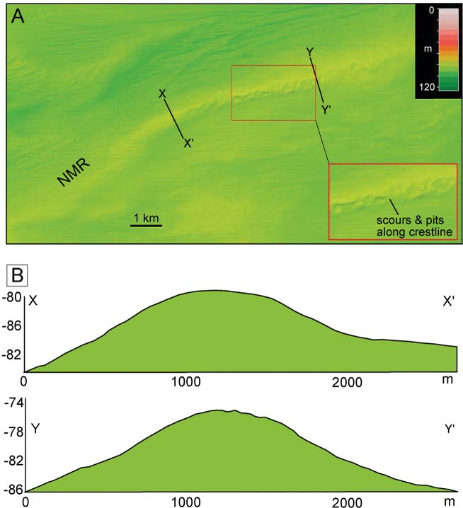
North of Lewis, on the mid shelf in water depths of 100–120 m, are two large broad ridges trending across the wide cross-shelf trough linking the Minch to the Sula Sgeir Fan. The outer ridge, which we call the North Lewis Ridge, ranges in width from 2 km to 5 km and has a maximum height of 20 m above the surrounding sea floor. This discontinuous ridge is 40–50 km long; however, the single-beam bathymetry data is sparse in the central part of the ridge system, which consequently remains undefined. The main ridge is curvilinear in form, arcing round from a northerly orientation offshore northernmost Lewis to a NE–SW orientation in its northern part; i.e., concave in plan form towards mainland Scotland. Bathymetric cross-profiles show no preferred slope asymmetry (Fig. 5). Seismic profiles show this region of seafloor is characterised by a featureless, in places acoustically transparent unit, which correlates with a 20 m-thick stiff foraminiferous clay proved in BGS borehole 77/08 (Fyfe et al. Reference Fyfe, Long and Evans1993). The inner broad ridge, which we here call the North Minch Ridge, is a well imaged feature in the single-beam data, trending generally NE–SW between the North Lewis and North Minch basins. This continuous ridge is 20–25 km long, 10–20 m high and 3–6 km wide, with linear and curvilinear sections in plan form. Single-beam echo sounder data show that the North Minch Ridge is asymmetrical in cross-profile in its central section, with a steeper NW-facing (distal) slope and a single broad crest line (Fig. 4). Bedrock does not outcrop in the vicinity of this ridge (BGS 1989, 1994). BGS seismic profiles show a thick Quaternary succession in and around the North Lewis Basin, and BGS borehole 77/08 on the flank of the North Minch Ridge recovered >20 m of stiff pebbly clay with arctic microfauna, indicating glaciomarine sedimentation (Fyfe et al. Reference Fyfe, Long and Evans1993). Approximately midway along the North Minch Ridge, a large broad flat-topped approximately rectangular mound occurs to the south, with a width of 5 km, a length of 8 km and a general N–S elongation. BGS seismic data show a considerable thickness of Quaternary sediment in this region (>50 m); however, the seismostratigraphic sequence is unclear, with the Pleistocene deposits left undifferentiated (Fyfe et al. Reference Fyfe, Long and Evans1993). Currently, no multibeam data exist for the outer or mid shelf NW of Lewis (Fig. 2); however, the eastern part of the North Lewis Ridge is captured by multibeam bathymetry data (Fig. 6). This high-resolution bathymetry reveals a broad ridge 2–3 km wide, with a generally smooth surface texture and no overall slope asymmetry, similar in form to large subaqueous moraines seen on the outer shelf (Stoker & Holmes Reference Stoker and Holmes1991) (Fig. 7). Of particular note is the irregular pitted and scoured surface of the ridge crest along a 5 km-long section (Fig. 7). In this relatively shallow shelf setting (<80 m present-day water depth), these are interpreted as keel marks of large icebergs, probably indicating former proximity to a calving ice-sheet margin.
(A) Hill-shaded multibeam bathymetry data, and (B) bathymetric cross-profiles of North Minch Ridge on the mid shelf, ∼40 km NW of Cape Wrath, in present-day water depths ca. 80 m. Note the irregular pitted surface, suggestive of iceberg keel marks and scours. Contains Maritime and Coastguard Agency MBES data.
Near the Flannan Isles, in the extreme west of the study area, are two large seabed ridges. The first is a broad low-elevation 15 km-long ridge trending NE–SW at around 100 m present-day water depth on the outer shelf (Figs 4, 5). This ridge is 2–5 km wide and typically 10–15 m high. BGS seismic profiles show a thin acoustically chaotic wedge of sediment draped on irregular basement bedrock in this area (Stoker et al. Reference Stoker, Hitchen and Graham1993). The second feature is a broad low-elevation ridge starting 20 km NW of Bernera, west Lewis, which we term the East Flannan Ridge. At its maximum, it is 4 km wide, 10 m high and 25 km long, and is weakly arcuate to the south where it is bounded by the Flannan Trough. This ridge may be partly bedrock controlled to the north, as seen in its irregular cross-profile, and terminates to the west on the submerged bedrock platform surrounding the Flannan Isles (Fig. 4). BGS seismic profiles show a thin poorly resolved sediment unit draped on bedrock, and seabed sediment maps show a broad belt of sandy gravel coincident with the East Flannan Ridge.
In the eastern Minch, large, arcuate seabed ridges occur in nearshore waters in present-day water depths of up to 100 m (Figs 5, 6). A number of these are clearly visible in the single-beam dataset, the most notable being a large ridge 1–2 km wide, up to 35 m high and nearly 20 km long, which extends N from the Stoer Penisula and arcs through almost 90 degrees to trend NW in the vicinity of Loch Laxford (Fig. 5). This large prominent sharp-crested ridge, here termed the Eddrachillis Ridge, has a simple asymmetric profile with a gentler eastern (proximal) flank and a steeper (distal) western flank – typical of large end moraines or grounding-zone features in submarine settings (e.g. Dowdeswell et al. Reference Dowdeswell, Ottesen, Evans, Ó Cofaigh and Anderson2008; Ó Cofaigh Reference Ó Cofaigh2012). Five similar but smaller sharp-crested ridges, 5–15 m high and 250–500 m wide, occur 1–2 km inshore of the Eddrachillis Ridge, all with similar asymmetric profiles – characteristic of recessional push moraines charting ice retreat from NW to SE.
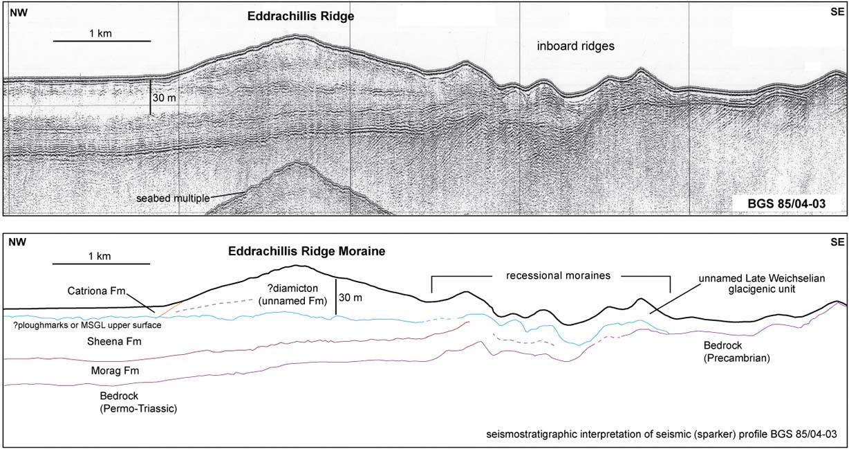
A BGS seismic profile (sparker) across the Eddrachillis Ridge (Fig. 8) shows it is comprised of a single generally chaotic to acoustically transparent unit, with very few internal structures unconformably deposited on underlying strata, typical of glacigenic (morainic) diamicton laid down at the margin of a grounded ice sheet. The five smaller inshore ridges are comprised of the same laterally continuous acoustic unit. In the SE, this uppermost glacigenic unit directly overlies Precambrian bedrock; in the NW it is deposited on an offshore-thickening stacked sequence of Late Pleistocene sediments, interpreted elsewhere as subglacial and ice-proximal glaciomarine facies (Sheena Formation, Morag Formation) (Fyfe et al. Reference Fyfe, Long and Evans1993) (Fig. 8). The innermost ridge in the sequence has a very similar seismic expression and morphology to recessional moraines found on the seabed in the Summer Isles region to the south (see below) (Stoker et al. Reference Stoker, Bradwell, Howe, Wilkinson and Mcintyre2009). The stratigraphic position of the unnamed uppermost glacigenic unit (comprising the Eddrachillis Ridge and adjacent inshore ridges) within the existing regional seismostratigrphic framework is currently unclear. However, its superposed stratigraphic position and well-preserved seabed morphology demonstrate a late-stage glacial event, younger than the Sheena Formation (Upper Weichselian) but older than the Late-glacial climate reversal (Greenland Interstadial/Stadial 1), and therefore probably within the time period ∼20–15 ka BP.
BGS sparker profile (upper panel) and seismostratigraphic interpretation (lower panel) of the Eddrachillis Ridge, eastern part of the Minch. This large 30–40 m-high ridge and the smaller ridges inboard to the SE have not been formally defined within the existing Quaternary stratigraphic framework. The collective evidence suggests they are relatively late-stage (MIS2) subaqueous moraines recording grounded ice-sheet margin oscillations offshore mainland NW Scotland. For line of section, see Figure 1.
The Eddrachillis Ridge may represent a northern equivalent of a similarly prominent late-stage moraine system imaged at the mouth of Loch Ewe and around the Rubha Coigach headland (Stoker et al. Reference Stoker, Bradwell, Howe, Wilkinson and Mcintyre2009) (Figs 5, 6). The Loch Ewe–Greenstone Point moraine complex is 1–2 km wide, up to 30 m high and >15 km long and forms a long broad arc open to the SE. Low-resolution echo sounder data suggest a bathymetric connection between this moraine complex and the morphologically similar moraines around the Rubha Coigach headland ∼20 km to the NE, although multibeam data is lacking in this intervening area. Multibeam echo sounder data acquired by BGS (in 2005) and new baythmetry data from the eastern Minch acquired by MCA (in 2011) show the detailed geomorphology of this substantial moraine complex, in present-day water depths of 30–100 m. The larger moraines indicate firmly grounded retreat, whilst the superimposed de Geer moraines (1–5 m high; <100 m wide) suggest lightly grounded retreat of a tidewater glacier margin close to flotation (Stoker et al. Reference Stoker, Bradwell, Howe, Wilkinson and Mcintyre2009; Stoker & Bradwell Reference Stoker and Bradwell2011)
Morphologically similar seabed ridges occurring to the N of the Eddrachillis Ridge are well imaged on single-beam data (Fig. 5). They form a nested sequence of nearshore ridges, ca. 10–20 km to the W and NW of Loch Inchard, in present-day water depths of 40–65 m. They are referred to here as the NW Sutherland ridges (Fig. 5). These five or six ridges vary in size and shape, but all trend in the same direction (NE–SW); most of the ridges are generally arcuate in plan form, concave to the SE (Fig. 6). The outer ridges are broader and generally lower, whilst the inner ridges are higher and better defined; the innermost ridge is the most pronounced, being <1000 m wide and rising 20 m from the seabed. Most of the ridges have no overall slope asymmetry in cross-profile (Fig. 5). The inner ridges due west of the Sheigra headland, when projected along trend, would make landfall in the vicinity of Sandwood Bay; the outermost ridges would make landfall further N in the vicinity of Cape Wrath (Fig. 6). BGS seismic lines across this part of the eastern Minch show these sediment ridges to have a similar acoustic character to the Eddrachillis Ridge – with a single acoustically chaotic unit unconformably overlying an irregular bedrock reflector, characteristic of diamicton-dominated end moraines. Unfortunately, this group of well-developed ice-sheet moraines is outside the area covered by existing multibeam data (Fig. 2); hence more detailed morphological information is currently lacking.
All the nearshore moraines in the eastern Minch described in this section are relatively large, well defined, morpho-stratigraphically equivalent features in similar water depths. We therefore suggest they were broadly coeval in formation and informally assign these moraines to the Late Pleistocene deglacial succession, stratigraphically older than the Assynt Glacigenic Formation (<16 ka BP) further inshore and stratigraphically younger than the Fiona Formation–Loch Broom Till Formation (∼20–25 ka BP) (Stoker & Bradwell Reference Stoker and Bradwell2011).
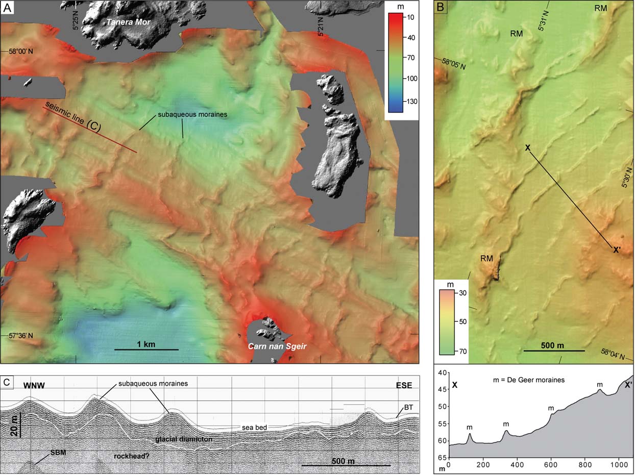
In the south of the study area, from the Gairloch and Coigach headlands inshore to the heads of the fjords (Loch Ewe, Loch Broom and Little Loch Broom) are numerous transverse seabed ridges in water depths typically of 30–100 m (Fig. 9). This part of the eastern Minch, known as the Summer Isles region, was surveyed with multibeam echo sounder and sub-bottom acoustic profiling by BGS in 2005, and over 100 seabed cores were recovered in separate scientific cruises in 2006 and 2009. The results of these data acquisitions have been the focus of detailed geomorphological and geological studies (Stoker et al. Reference Stoker, Bradwell, Wilson, Harper, Smith and Brett2006, Reference Stoker, Bradwell, Howe, Wilkinson and Mcintyre2009; Stoker & Bradwell Reference Stoker and Bradwell2011). Over 50 seabed ridges have been mapped in the area trending generally SSW–NNE and varying in length from 0.5 km to 5 km; ridge spacings typically range from 500 m to 1000 m. There are two distinct sets: an older group of more substantial ridges (5–15 m high; 80–150 m wide), and a younger group of smaller more delicate ridges (2–5 m high; 30–50 m wide), superimposed on the earlier ridges (Fig. 9). Most ridges are simple in plan form, consisting of linear sections; however some are more intricate in plan form, describing intricate or zigzag patterns. Occasionally, ridges continue to water depths of 100 m, but in basins and bathymetric deeps the ridges are notably absent. The larger ridges are typically asymmetric in cross-profile, whilst the smaller more delicate ridges tend to be symmetrical. BGS seismic profiles show the ridges to be typically composed of a single acoustically chaotic or structureless unit draped unconformably on an irregular bedrock surface (Fig. 9). A core taken from the flank of a seabed ridge recovered a massive, poorly sorted, sandy to muddy diamicton, with numerous striated clasts of non-local lithology (Stoker et al. Reference Stoker, Bradwell, Howe, Wilkinson and Mcintyre2009). The whole suite of seabed ridges have been lithostratigraphically assigned to the Assynt Glacigenic Formation and are interpreted as subaqueous moraines (and/or de Geer moraines), formed at the grounded, or partially buoyant, tidewater margin of a retreating ice sheet (Stoker et al. Reference Stoker, Bradwell, Wilson, Harper, Smith and Brett2006, Reference Stoker, Bradwell, Howe, Wilkinson and Mcintyre2009). In places, around the mouths of Loch Broom and Little Loch Broom, these moraines have clear onshore counterparts which have been studied, and in places dated, with terrestrial cosmogenic nuclides (∼15 ka BP; Bradwell et al. Reference Bradwell, Fabel, Stoker, Mathers, Mchargue and Howe2008b).
Seabed moraines in the Summer Isles region, NW Scotland (mapped and studied previously by Stoker et al. Reference Stoker, Bradwell, Wilson, Harper, Smith and Brett2006, Reference Stoker, Bradwell, Howe, Wilkinson and Mcintyre2009; Bradwell et al. Reference Bradwell, Fabel, Stoker, Mathers, Mchargue and Howe2008b): (A) hill-shaded multibeam bathymetric image showing suite of transverse ridges (moraines) between Tanera Mor and Carn nan Sgeir. [Multibeam echo sounder data acquisition by BGS]; (B) hill-shaded multibeam bathymetric image of seabed moraines ∼10 km NW of Tanera Mor. Note the small delicate de Geer moraines (m) overprinting the larger (older) set of regional moraines (RM). Location of bathymetric profile (lower panel) shown by line; (C) BGS seismic reflection (boomer) profile of subaqueous moraines between Tanera Mor and Carn nan Sgeir. Note the asymmetric cross-profile. Rockhead/diamicton contact mapped where acoustically resolvable. Line of seismic profile shown in (A). Abbreviations: SBM=seabed multiple; BT=bottom tracking pulse. Modified from Bradwell et al. Reference Bradwell, Fabel, Stoker, Mathers, Mchargue and Howe2008b.
3.1.2. Central sector
The seabed in the central sector of the study area is generally shallower, more rugged and more topographically variable than the shelf areas to the SE and NW. The bathymetry is punctuated by a number of large structural bedrock highs and platforms on the mid shelf; these include the North Rona, Solan Bank, and Nun Rock–Sule Skerry Highs (Fig. 1). Extensive single-beam data coverage and good multibeam data coverage exists for this part of the shelf, affording an excellent view of the seabed geomorphology (Fig. 5). The seabed in this central sector is characterised by an abundance of seabed ridges, with over 100 mapped in this study.
Approximately 5–30 km from the shelf break, on the outer shelf, ∼30–50 km NE of North Rona, at least four large, broad ridges extend semi-continuously for ∼100 km in a NE–SW direction parallel to the continental shelf break. They are typically 3-4 km wide, increasing in width (to 4–5 km) to the NE, with smooth subdued cross-profiles (Fig. 5). The ridges are generally low-elevation features ranging in height from 10 m to 20 m. Overall, the ridges are broadly arcuate in plan form but with long linear sections (Fig. 6). The exact plan morphology of the ridges is not easy to establish, even with image enhancement, owing to their subdued form and the vertical resolution of the single-beam data. However, the new mapping is an improvement on that presented in Bradwell et al. (Reference Bradwell, Stoker, Golledge, Wilson, Merritt, Long, Everest, Hestvik, Stevenson, Hubbard, Finlayson and Mathers2008a) and gives a better impression of the lateral continuity and spatial interrelationship of these ridges; for example, it is clear that the outermost fragmentary ridge is cut out or overprinted, at least in part, by the adjacent inshore ridge (Fig. 6). BGS seismic profiles across this part of the outer shelf show acoustically structureless or chaotic packages in the upper part of the sequence (<40 m thick) which occasionally interdigitate with layered deposits near the shelf break. BGS seismostratigraphic mapping, supported by borehole evidence, places these NE–SW-trending broad ridges within the Murray or MacDonald Formations (Stoker et al. Reference Stoker, Hitchen and Graham1993; BGS 1994) – a Late Pleistocene suite of ice-proximal to glaciomarine sediments laid down prior to the Otter Bank Formation (Stoker & Holmes Reference Stoker and Holmes1991). Whereas, spatial relationships revealed in the new bathymetry data (this study) suggest that the inner three ridges can be traced onto the northernmost part of the Hebrides Shelf, seemingly offering a potential correlation with the MacDonald Formation moraines at seabed; their stratigraphic relationship (angular discordance) with other Pleistocene deposits must be taken into consideration in any proposed reconstruction (Fig. 4).
Further inshore, on the mid shelf to the NE of North Rona, another group of seabed ridges are well imaged on the single-beam bathymetry. For convenience, we term these collectively the N Rona Ridges (Fig. 5). Four large broad ridges, interspersed with several smaller ridges, occur in present day water depths of 80–130 m, in a region of highly variable bathymetry, including the North Rona Basin and western part of the Solan Bank High (Figs 5, 6). The larger ridges are 2–4 km wide and 10–20 m high; the smaller ridges are up to 2 km wide and of similar vertical relief (10–20 m). The North Rona ridges arc round from a NE–SW trend to an E–W trend in their eastern parts and extend for ∼50 km on the mid shelf, where they abut a larger feature (the Solan Bank Ridge) on the mid shelf. The inner suite of ridges appear to fan out from the North Rona High, suggestive of topographic pinning; whereas the outer suite of ridges are more shelf-edge parallel features (Fig. 6). Most of the ridges comprise discontinuous sections, with the longest continuous ridge extending for ca. 30 km. The spacing between successive ridges is relatively close near the North Rona High, with six main seabed ridges mapped in only 15 km of horizontal distance (Figs 5, 6).
Multibeam bathymetry covers only a small part of this area to the east of North Rona (Fig. 2). Here, the 3-D shape and smooth surface of the North Rona sediment ridges can be clearly seen, as well as their unconformable relationship with the underlying basement bedrock. These ridges have strong morphological similarities with subaqueous moraines mapped elsewhere in the study area (e.g., in the eastern Minch) and in other glaciated continental shelf settings (e.g., Shaw et al. Reference Shaw, Piper, Fader, King, Todd, Bell, Batterson and Liverman2006; Todd et al. Reference Todd, Valentine, Longva and Shaw2007; Dowdeswell et al. Reference Dowdeswell, Ottesen, Evans, Ó Cofaigh and Anderson2008). Unfortunately, this whole region is not well resolved in BGS seismic lines, as bedrock is near to seabed across much of the area and correlation of thin discontinuous Pleistocene sequences is difficult (Fig. 3). However, BGS Quaternary geology maps and offshore reports assign the Pleistocene deposits in this region to the Otter Bank Formation: a heterogeneous glaciogenic unit comprising ice-proximal diamictons, glaciofluvial/deltaic gravelly sands and glaciomarine pebbly muds (Stoker et al. Reference Stoker, Hitchen and Graham1993; BGS 1994). Interestingly, the narrower innermost E–W-trending North Rona moraine ridge seems to join, or be truncated by, a broader NNE–SSW-trending sediment ridge in shallow water, projecting from the northern edge of the Solan Bank High, but the exact morphological relationship remains unclear (Fig. 6).
A prominent NNE–SSW-trending bathymetric high crosses the mid shelf between the submerged bedrock high of the Solan Bank (60 m water depth) and the main Otter Bank Formation Moraines (100–120 m water depth). This prominent 10–20 km wide, 80 km long feature is a structural bedrock platform – referred to as the Solan Bank High. BGS investigations proved basement rocks of the Lewisian complex at seabed on the Solan Bank and the adjacent Sule Skerry-Nun Rock high (Ritchie et al. Reference Ritchie, Ziska, Johnson and Evans2011). BGS borehole 77/07 recovered weathered basement rocks at shallow depth beneath Tertiary and Neogene deposits on the spine of the Solan Bank High (Stoker et al. Reference Stoker, Hitchen and Graham1993). Although predominantly a bedrock feature, seismic records show that the eastern portion of the platform is capped by a thin Pleistocene sequence (Otter Bank Formation) which thickens to the northeast (Stoker et al. Reference Stoker, Hitchen and Graham1993). We map a low broad NNE–SSW-trending sediment ridge along the length of the eastern side of the Solan Bank High which we call the Solan Bank Ridge. It is 3–4 km wide and generally rises only 10–15 m above the surrounding seafloor, with low angle slopes and a very poorly defined crest line (Fig. 6). However, its geometry is consistent with other subtle ice sheet moraines seen on the mid and outer shelf. A morphologically similar broad, low ridge occurs on the northern part of the Solan Bank High where the glacigenic Otter Bank Formation thickens, forming more pronounced moraines (morainal banks) (Stoker et al. Reference Stoker, Hitchen and Graham1993).
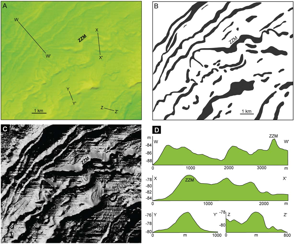
Inshore of the Solan Bank High, the number and density of seabed ridges increase considerably (Fig. 10). This area of rugged seafloor, punctuated by numerous bedrock highs, is well imaged in both the single-beam and multibeam data. The density of seabed ridges is typified in the area S of Solan Bank around Nun Rock – a rugged basement high that reaches to within −30 m of present-day sea level (Figs 1, 4). Detailed mapping of ridges in this region reveals numerous sediment ridges with complex plan form morphology and variable 3D shape (Figs 10, 11). The ridges on this part of the shelf have notably more variable geomorphology than the broad simple plan form ridges seen on the outer and mid shelf (Figs 5, 6). Some show clear overprinting or superimposed relationships (Fig. 10). The seabed ridges inshore of the Solan Bank High and around Nun Rock generally fall into two types: broader, more substantial, ridges with widths ca. 200–1000 m and heights of 5–10 m; and narrow, more delicate, ridges with widths ca. 100 m and heights of only 1–3 m above the surrounding seafloor. The larger ridges have variable geomorphology, often with strongly arcuate sections and numerous inflection points (Fig. 11). Ridge crests are generally broad and rounded; along-ridge heights can vary; most are slightly asymmetric in cross-profile, steeper on their shoreward (proximal) side. They are also nearly always continuous features, with very few breaks or missing sections. By contrast, the smaller ridges tend to be simple in plan form, with linear or curvilinear sections, and rarely extend more than 2–3 km without a break. Ridge crests are sharper and better defined; however, slope asymmetry is often lacking.
Seabed moraines in the central sector, SW of Nun Rock High: (A) hill-shaded multibeam bathymetry data showing area of dense seabed ridges interpreted as ice-sheet moraines; (B) outline geomorphological map of seabed ridges. Note how the morphology of zigzag moraine (ZZM) overprints adjacent (older) ridges, suggesting a re-advance of the ice sheet margin; (C) hill-shaded greyscale bathymetric surface model, illuminated from the NW, used to map ridge morphology and crest lines in detail; (D) bathymetric cross-profiles of closely spaced, well developed seabed moraines SW of Nun Rock; profile lines shown in (A). For bathymetric colour ramp, see Figure 7. Contains Maritime and Coastguard Agency MBES data.
Seabed moraines in the central sector, S of Nun Rock High: (A) hill-shaded multibeam bathymetric image showing suites of transverse ridges between Nun Rock and Cape Wrath; (B) outline geomorphological map of ridges (large and small) interpreted as ice sheet moraines; stipple is bedrock at seabed; (C) bathymetric transects perpendicular to ridge crests showing cross-profile (2-D) morphology of selected ridges. Depths and distances in metres. Lines of transects shown in (A); (D) BGS seismic reflection (airgun) profile across seabed moraines S of Nun Rock. Line of profile shown in (A) and (B). Note the Pleistocene sediment package thickening in the vicinity of the Nun Rock moraine; sediment cover is thin or absent in places to the east. For bathymetric colour ramp, see Figure 7. Contains Maritime and Coastguard Agency MBES data. Abbreviations: NRM=Nun Rock Moraine; RM1, RM2=regional moraines; m1, m2=smaller recessional moraines; SBM=seabed multiple.
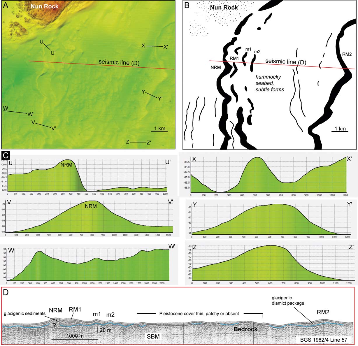
Immediately south of Nun Rock is an excellent example of one of the large continuous ridges found in the central part of the shelf off northern Scotland (Fig. 11). The ridge starts in the shallow water adjacent to Nun Rock and ends on the bedrock platform around Cape Wrath, traversing water depths from 55 m to 95 m below present-day sea level. Running almost due N–S and unbroken for 22 km, we term this the Nun Rock Ridge. The ridge ranges in width from ∼250 m to ∼1000 m and averages around 8–10 m in height. Bathymetric cross-profiles show that asymmetry is typical, with slope gradients of between 50:1 and 80:1 and a generally steeper E-facing slope (Fig. 11). The continuous, well-defined morphology of this feature on the seabed is striking. In particular, the arcuate, almost semi-circular, ridge sections concave to the E–SE; the numerous strong kinks or inflections where the ridge direction changes by up to 90 degrees; and the irregular, multi-lobed, overall plan form of the ridge (Fig. 11).
The BGS seismostratigraphic framework is poorly developed in the nearshore region around NW Scotland, with most deposits defined simply as “Quaternary undifferentiated” (Fig. 4). This is largely owing to the thin (<5–10 m) and patchy nature of the Pleistocene deposits on bathymetrically rough seabed (BGS 1989; Stoker et al. Reference Stoker, Hitchen and Graham1993). The Nun Rock Ridge is only poorly resolved on one or two BGS seismic profiles (airgun and sparker), owing to its small size, but is composed of a structureless, acoustically transparent unit, unconformably overlying highly reflective substrata interpreted as hard (?crystalline) bedrock (Fig. 11). BGS borehole 72/34, situated on the flank of the ridge, proved 8.5 m of grey silty, sandy clay with ice-worn pebbles and occasional sand lenses, typical of a glacial diamicton, overlying bedrock (Stoker et al. Reference Stoker, Hitchen and Graham1993). Maps made from seabed sediment samples show gravelly sands and gravels predominating on the highs (ridges), whereas sands predominate in the basins (BGS 1989). Taken collectively, the morphological and geological evidence, combined with the similarity to well-studied glacial features identified elsewhere on the seabed around NW Scotland (e.g. Stoker et al. Reference Stoker, Bradwell, Wilson, Harper, Smith and Brett2006, Reference Stoker, Bradwell, Howe, Wilkinson and Mcintyre2009), strongly favours the interpretation of the Nun Rock Ridge as a prominent end moraine, relating to a still-stand or oscillation of a grounded ice sheet margin.
Immediately adjacent to this seabed moraine, 1–2 km E, another less continuous but comparably-sized ridge mirrors its plan form shape with curves and inflection points in similar places along much of its length (Fig. 11). Approximately 10 km E of this, a further prominent seabed ridge occurs with similar dimensions and characteristic curved-and-kinked morphology. Like the Nun Rock Moraine, this broad-crested ridge is also asymmetric in cross-profile, with E- and W-facing slope gradients of 80:1 and 100:1 (Fig. 11). Based on their geomorphological similarity and spatial coherence with the Nun Rock Moraine, we also interpret these substantial ridges as end moraines, part of a suite of ‘regional moraines’ imaged in multibeam bathymetry data charting the retreat of a grounded ice sheet margin offshore northern mainland Scotland (Figs 6, 11).
The smaller, more delicate ridges, seen immediately W of the Nun Rock Moraine, form a different suite of four (or possibly five) ridges on the seabed. With wide spacings of 500–1000 m and heights of only 1–3 m, these ridges bear little similarity to marine (sediment transport) bedforms; their contextual setting adjacent to, and between, ice sheet moraines suggests a Pleistocene age and origin. Although geological and acoustic information about their composition is lacking, their morphological similarity to small subaqueous transverse moraines (de Geer moraines), identified elsewhere in formerly glaciated continental shelf settings, is strong (e.g. Ottesen & Dowdeswell Reference Ottesen and Dowdeswell2006; Todd et al. Reference Todd, Valentine, Longva and Shaw2007; Bradwell et al. Reference Bradwell, Fabel, Stoker, Mathers, Mchargue and Howe2008b). On this basis, we map these suites of smaller ridges in the vicinity of Nun Rock as de Geer-type moraines formed by incremental retreat of an ice-sheet grounding line over time (e.g. Lindén & Möller Reference Lindén and Möller2005). The stratigraphic and temporal relationship between these smaller moraines and the more substantial regional moraines is not clear, although there is a suggestion in the multibeam data that the former overprint or truncate the latter in places. It is very likely, judging by their good state of preservation, that all these moraines relate to the last (Late Weichselian) BIIS.
Multibeam echo sounder data also reveal an irregular hummocky area of seabed geomorphology, with faint linear N–S-orientated forms between the two large regional moraines (Fig. 11; RM1 and RM2). Sub-bottom geophysical profiles show thin and patchy Pleistocene sediment cover with bedrock at or close to seabed (Fig. 11); geological maps (BGS 1989, 1984) show undifferentiated Quaternary deposits in this area, with gravelly seabed sediments predominating. It is likely that some of the hummocks and discontinuous linear forms in the multibeam data may be glacigenic (morainic) in origin. It is notable that a further three small, delicate, morphologically distinct, but discontinuous ridges are seen with the same N–S orientation on the eastern margin of this hummocky area near RM2. We interpret these small discontinuous ridges as de Geer moraines, part of the Nun Rock moraines suite (described above).
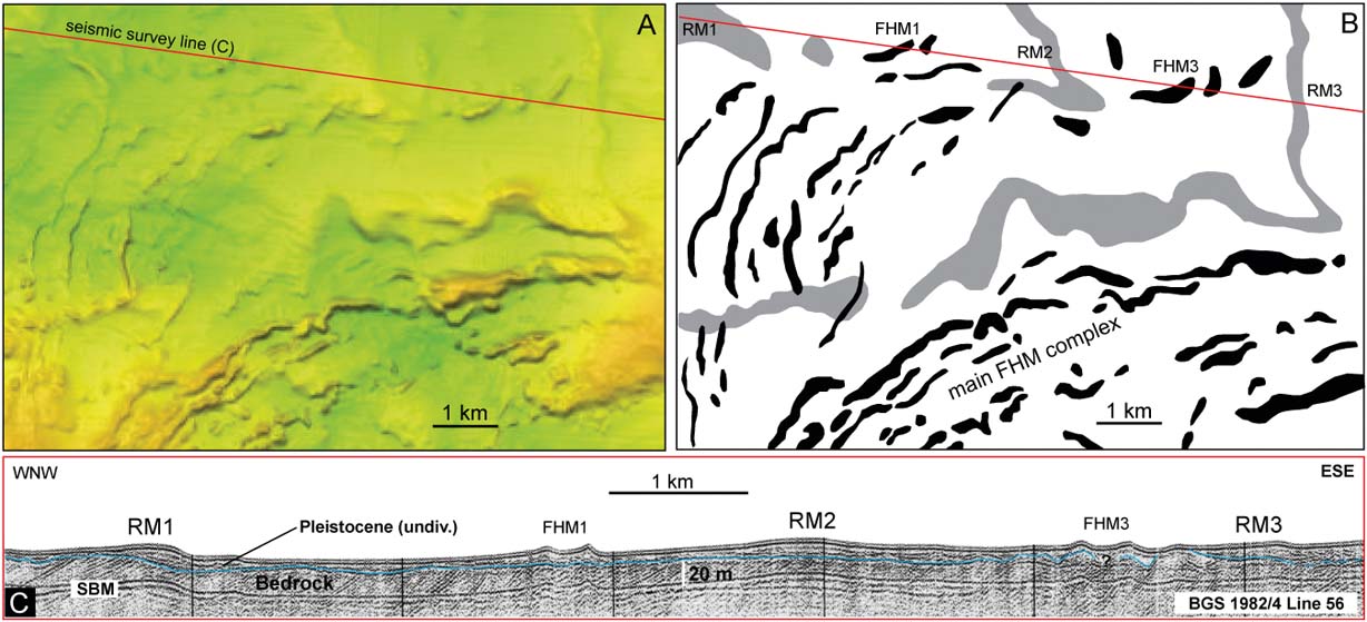
The suite of regional moraines imaged between Cape Wrath and Nun Rock continue eastward at a high angle to, in places almost perpendicular to, the present-day north coast of Sutherland (Fig. 6). A notable deviation from this trend is offshore Faraidh Head, N of the mouth of Loch Eriboll in water depths of 50–70 m, where large, morphologically similar, but more pronounced, transverse ridges are seen to interrupt or overprint this regional pattern (Fig. 12). Interpreted as a subsequent suite of ice-marginal landforms, the Faraidh Head moraines form a group of up to ten discrete arcuate, but laterally discontinuous, nested ridges. Their geomorphological and acoustic similarity with the Nun Rock moraines, as well as their discontinuous concentric pattern, is strongly suggestive of a grounded or partly grounded ice margin retreating from N to S – evidence of a locally-sourced ice mass in the mountains of NW Scotland (Fig. 12). The superimposition of one set of moraines on another in this area suggests that a major local ice sheet/ice cap re-advance occurred in NW Sutherland and, furthermore, that final retreat of this ice mass probably occurred under marine conditions; hence the preservation of both sets of landforms.
Seabed moraines off the Sutherland coast due N of Faraidh head: (A) hill-shaded multibeam bathymetric image showing the area of complex multi-phase glacial geomorphology; (B) outline geomorphological map of transverse seabed ridges interpreted as ice-marginal landforms (moraines). Larger, older ridges (grey) are regional moraines relating to ice sheet retreat generally from west to east; smaller, younger ridges (black, FHM) relate to a later phase of advance and retreat of an ice mass sourced to the S, in NW Sutherland; (C) BGS seismic reflection (airgun) profile across seabed moraines off Faraidh Head. Line of survey shown in (A) & (B). Pleistocene sediment package is locally up to 20 m thick in ridges, although sequence is undivided. Exact stratigraphic relationship between regional moraines and Faraidh Head Moraines is uncertain, owing to low resolution of airgun profile; however, geomorphology shows the latter, more pronounced, ridges superimposed on the former, broader ridges, in places. Abbreviations: FHM=Faraidh Head Moraines; RM=Regional Moraines; SBM=Seabed multiple. For bathymetric colour ramp, see Figure 6. Contains Maritime and Coastguard Agency MBES data.
Further E in the central sector, the single-beam bathymetry data shows the suite of regional moraines continuing adjacent to theN coast of Sutherland and Caithness (Fig. 6). The spatial pattern of the ridges continues, with lobate or broadly arcuate plan forms open to the E or SE. Bathymetric cross-profiles also show similar height and widths to the moraines in the vicinity of Nun Rock, and generally steeper E-facing slopes. In several places, between Faraidh Head and Dunnet Head, these large moraines are truncated or overprinted by another set of equally substantial seabed ridges; implying a subsequent phase of glacial advance–retreat. One notable ridge complex highlights this relationship. A broad seabed sediment ridge can be seen extending offshore in an ENE direction to the east of Strathy Point (Fig. 6). If projected onshore, this ridge would make landfall in the vicinity of Melvich Bay; hence we call this the Melvich Ridge. Approximately 15 km N of Sandside (Reay) Bay, this broad subdued ridge is overprinted by another smaller, but more prominent seabed ridge with a well-developed crest line (Fig. 13). This sharp-crested ridge forms a wide arc stretching over 40 km from the Caithness coast, between Reay and Brims Ness, to 10 km W of Hoy in Orkney. Good quality single-beam bathymetry data shows that this ridge is 400–1000 m wide and typically 10–20 m high, with an unusual asymmetry, being generally steeper on its W-facing slopes. In places, the ridge crest line widens, bifurcates or splits into two well-defined ridges, with one ridge set ∼1 km inside the other (Fig. 13). At a point c. 10 km W of Rora Head on Hoy, the ridge sharply changes direction, and continues with the same distinctive sharp-crested morphology in a northerly direction in present-day water depths of 60–80 m. Unfortunately, this ridge is not well imaged in existing seismic sub-bottom survey lines; although an airgun profile clearly shows the twin-crested morphology of the ridge, its relatively high-angle slopes and asymmetry (steeper W-facing slopes) (Fig. 13). As elsewhere on the inner continental shelf, the 3-D morphology (e.g., height, width, shape, etc.) and geospatial similarity (e.g., spacing and trend) of the ridges between Faraidh Head and Dunnet Head to other seabed moraines imaged elsewhere on the UK continental shelf strongly suggest that they formed at the margin of a grounded ice sheet, probably during the Late Weichselian period. We suggest that the superimposed Reay Ridge represents a notable and spatially extensive moraine-forming event during overall ice-sheet retreat, when the ice sheet margin underwent a significant re-advance; in places, beyond the position of older moraines (Fig. 13).
Seabed moraines off the N Caithness coast: (A, B) hill-shaded single-beam echo sounder bathymetric images (Olex dataset); arrows highlight prominent arcuate sediment ridge (RR) abutting or overprinting older more subdued forms (MR): (A) illuminated from the NE; (B) illuminated from the NW. (C) BGS seismic reflection (airgun) profile across seabed offshore Caithness. Line of survey shown in (A), perpendicular to crest of ridges. Note the Pleistocene sediment package thickening to form a distinctive double crested ridge – the Reay Moraine. Steep-sided transverse sediment ridges to the E are similar to large Holocene sand waves seen elsewhere on the Continental Shelf; although seismic reflection data suggest some may be draped over Pleistocene (glacial) sediment cores. Abbreviations: MR=Melvich Ridge; RR=Reay Ridge; SBM=Seabed multiple.
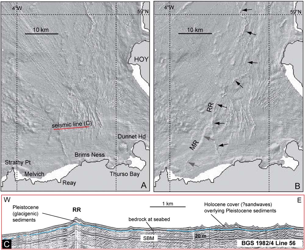
Three to eight kilometres east of the Reay Ridge are numerous closely spaced, prominent, sharp-crested seabed ridges trending generally N–S, but with irregular spacings and occasionally branching plan form (Fig. 13). The ridges are 1–20 m high and up to 1000 m wide; some are symmetrical in cross-profile, whilst others have strong asymmetry (both E-and W-facing) with asymptotic slopes. They are currently only imaged in single-beam, not multibeam, data. Their setting at the western entrance to the Pentland Firth in a hydrographic region renowned for its strong tidal currents (Kenyon & Stride Reference Kenyon and Stride1970) suggests that they are probably large-scale, mobile (but long-lived), sediment transport features (i.e., sand waves). Similar features have been mapped as sand waves on the seabed between Orkney and the Scottish mainland (Stoker et al. Reference Stoker, Hitchen and Graham1993). Seismic (airgun and sparker) profiles across this field of ridges are equivocal, showing prismatic structureless sediment bodies unconformably overlying acoustically bedded hard substrate (probably bedrock) (Fig. 13). However, the possibility that the ridges are reworked, glacigenic features (end/de Geer moraines) or have a glacial sediment core, cannot be ruled out at this time.
3.1.3. West Shetland Shelf and Orkney–Shetland Platform
Considerable previous work has been done on characterising the seabed morphology, seismic architecture and Quaternary geology of the West Shetland Shelf. The following section draws on this literature, whilst summarising the range of glacial landforms seen in the bathymetry data on the continental shelf around Orkney and west of Shetland.
Adjacent to the shelf break, in water depths of 160–200 m, are a suite of ridges; two large broad ridges and two smaller intervening ridges (Figs 5, 6). The longest of these extends semi-continuously for >120 km, beyond the northern limit of the study area, in a NE–SW direction, parallel to the continental shelf edge. The broad ridges are the largest depositional features imaged on the continental shelf, being typically 3–5 km wide and ca. 20–30 m high; the two intervening ridges are only 1–2 km wide (Fig. 6). All the ridges have smooth low-aspect cross-profiles, with very broad almost imperceptible crests. NW-facing (distal) slopes tend to be slightly steeper than SE-facing (proximal) slopes, though the exact plan morphology of the ridges is not easy to establish, even with image enhancement, owing to their subdued form. The ridges are part of a wider suite of glacigenic deposits on the West Shetland Shelf, identified in seismic data by Stoker & Holmes (Reference Stoker and Holmes1991) and interpreted as ice-sheet end moraines. This whole suite of shelf-edge and mid-shelf moraines forms part of the Upper Pleistocene (Late Weichselian) Otter Bank Formation, as defined by Stoker et al. (Reference Stoker, Hitchen and Graham1993, Reference Stoker, Balson, Long and Tappin2011a). Further work on their acoustic character and internal architecture has been carried out by Davison (Reference Davison2005).
New mapping of these moraine ridges from echo sounder imagery (Fig. 6) shows their spatial relationships more clearly; with the inner broad ridge abutting, and partially overprinting, the outer ridge along the northernmost part of the shelf in the study area. The moraines appear to stop abruptly where the shelf edge (200 m water-depth contour) makes a re-entrant inshore – known as the Foula Bight (Figs 1, 6). BGS seismic profiles across this part of the outer shelf show relatively thin (<20 m thick) acoustically structureless or chaotic packages within the broad ridges (Otter Bank Formation) passing laterally into layered deposits, part of the Morrison Formation on the West Shetland Slope (Stoker et al. Reference Stoker, Hitchen and Graham1993; Stoker Reference Stoker, Scrutton, Stoker, Shimmield and Tudhope1995; Davison Reference Davison2005).
Approximately 20 km to the SW, on the mid shelf, is another suite of large broad ridges, (∼2–5 km wide; 20–50 m high) with concentric, arcuate or lobate morphology, some with zigzag or convoluted plan forms. The whole suite has been interpreted as a complex of Late Weichselian ice-sheet end moraines; the outermost ridges forming part of the Otter Bank Formation, the innermost forming part of the Stormy Bank Formation (Stoker et al. Reference Stoker, Hitchen and Graham1993). The geomorphology and seismic architecture of this sequence has been described previously in detail by Stoker & Holmes (Reference Stoker and Holmes1991), Stoker et al. (Reference Stoker, Hitchen and Graham1993) and Bradwell et al. (Reference Bradwell, Stoker, Golledge, Wilson, Merritt, Long, Everest, Hestvik, Stevenson, Hubbard, Finlayson and Mathers2008a). These seabed landforms are clear in the single-beam bathymetry and represent the densest clustering of large moraines on the continental shelf within the study area (Figs 5, 6). Our mapping merely refines earlier work, showing that there are nine or ten large nested ridges within 50 km horizontal distance; some of them showing clear overprinting relationships.
Correlation of the outermost Otter Bank Formation moraines in this group with the large moraines W of Shetland (Stoker & Holmes Reference Stoker and Holmes1991; Stoker et al. Reference Stoker, Hitchen and Graham1993) is possible, based on seismostratigraphical and geomorphological grounds. However, correlation of the inner moraines in this group (Stormy Bank Formation) with ridge fragments on the West Shetland Shelf to the N remains equivocal, as a large area of bedrock occurs at seabed in this area ∼60°N (Fig. 6).
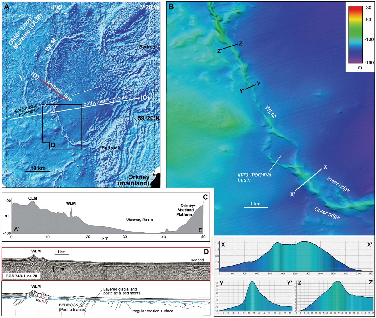
To the SE of the relatively shallow Otter Bank moraines (80–120 m water depth), the seabed deepens inshore, reaching −180 m in the parts of the broad Westray Basin, before rising abruptly at the Orkney–Shetland Platform (Fig. 14). A conspicuous well-defined ridge with a distinctive lobate or looped plan form occurs in water depths of ca. 110–130 m on this adverse-sloping seabed, ∼10 km to the SE of the main Otter Bank–Stormy Bank moraine complex described above. This ridge forms the innermost (youngest) large regional moraine within the Otter Bank–Stormy Bank sequence; we call it the Westray Loop Moraine (Fig. 14). This sharp-crested ridge forms a 70 km-long loop, with a remarkable degree of morphological continuity. Good quality single-beam and multibeam bathymetry data show that this ridge is 400–1600 m wide and typically 10–20 m high with strong asymmetry, being notably steeper on its E-facing (proximal) slopes. In places, the ridge crest line widens or splits into two well-defined ridges. Occasionally, these ridge bifurcations enclose small intra-ridge basins; one such notable basin is ∼1 km2 in area (Fig. 14). In other places, another small fragmentary ridge is set back 1–3 km inside the main ridge complex. The ridge has been previously interpreted by Bradwell et al. (Reference Bradwell, Stoker, Golledge, Wilson, Merritt, Long, Everest, Hestvik, Stevenson, Hubbard, Finlayson and Mathers2008a) as a lobate ice-sheet end moraine, possibly formed during a dynamic (?rapid) oscillation of the ice margin. BGS seismic data across the double-crested moraine would tend to support this interpretation, with strong parallel sub-surface reflectors within the ridge complex being truncated by a low-angle disruption plane at depth, interpreted here as a thrust (Fig. 14). Similar tectonic structures are often seen within contemporary thrust-block moraines, commonly associated with surging behaviour (Evans & Rea Reference Evans, Rea and Evans2003). Inboard of the Westray Loop Moraine, seismic reflection data show that the main part of the Westray Basin is covered in a relatively thick (>20 m), acoustically layered fill of glacial (?glaciomarine) and postglacial sediments overlying a strongly undulating, probably glacially moulded, erosion surface (Fig. 14).
Seabed moraines on the mid-shelf NW of Orkney: (A) hill-shaded echo sounder bathymetric surface model illuminated from the NW; dashed line shows join between single-beam and multibeam data; (B) hill-shaded multibeam bathymetry data showing the prominent Westray Loop Moraine (WLM) complex in detail (area of image shown in (A)). Lower panel: bathymetric profiles perpendicular to ridge complex showing different cross-profile (2-D) morphology of moraine at various points. Depths and distances in metres; (C) regional bathymetric transect showing depth profile of mid-shelf. Note the reverse (inshore-deepening) slope and location of main moraine complexes; (D) BGS seismic reflection (sparker) profile across Westray Loop Moraine and adjacent basin. Line of seismic profile shown in (A). Note the disrupted reflectors within the moraine ridge – possible evidence of glaciotectonic deformation. Contains Maritime and Coastguard Agency MBES data.
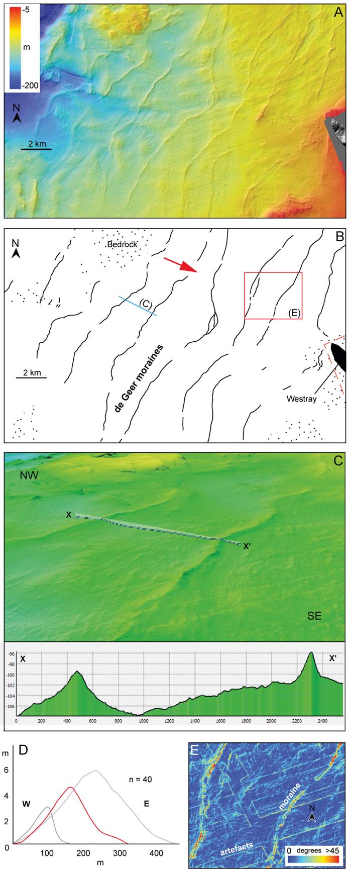
A large proportion of the seabed on the inner shelf around Orkney and Shetland consists of exposed bedrock, with structurally juxtaposed Lewisian, Moine, Devonian and Permo-Triassic rocks (Stoker et al. Reference Stoker, Hitchen and Graham1993; Ritchie et al. Reference Ritchie, Ziska, Johnson and Evans2011). This exposed bedrock is clearly imaged and can be mapped from the echo sounder bathymetry imagery, with a rugged highly irregular surface in multibeam data and a noisy chaotic seabed texture in single-beam data (Fig. 14). Across this predominantly bedrock seabed, numerous small sediment ridges are seen, particularly around northern Orkney and in the Orkney–Shetland Channel. These ridges generally occur in shallower water depths (<120 m below present-day sea level) and are well developed, continuous, linear features. Excellent examples are seen 5–20 km W of Westray on the gently sloping western flank of the Orkney–Shetland platform. Here, a suite of eight transverse ridges trends broadly NNE–SSW, in water depths of −120 m to −60 m, with linear, curvilinear or gently arcuate plan forms (Fig. 15). Most ridges can be traced semi-continuously for 20–30 km, although shorter ridge fragments <3–10 km in length also occur. Ridges are typically 100–300 m wide and 1–5 m in height. Ridge spacings are fairly regular and in the range of ∼1000–3000 m. Most ridges have simple crest lines, but one or two ridges bifurcate or display multiple crest lines. In cross-profile, ridge asymmetry is quite marked, with almost 60 % of moraine profiles (n=40) showing a steeper E-facing slope, although reversed asymmetry is noted locally (Fig. 15). Although no seismic sub-bottom profiles across these features were examined, the ridges are clearly draped directly on bedrock, corroborated by BGS seabed sediment maps, with little or no other Pleistocene deposits in the vicinity. The distinct morphological similarity of these transverse ridges with subaqueous moraines elsewhere strongly suggests that they are recessional moraines, probably de Geer moraines, deposited by a grounded ice front terminating in water (e.g., Lindén & Möller Reference Lindén and Möller2005; Ottesen & Dowdeswell Reference Ottesen and Dowdeswell2006). Large, isolated sandbanks, presumed to be Holocene, with distinctive slope morphology and E–W orientation are also seen in the shallows (<50 m water depth) close to the coast of Westray (Fig. 16).
Seabed moraines on the western flank of the Orkney–Shetland Platform: (A) hill-shaded multibeam bathymetry data showing suite of long transverse ridges W of Westray; (B) outline map of transverse seabed ridges interpreted as subaqueous recessional moraines. Red arrow indicates direction of ice-sheet retreat inferred from moraine morphology. Bedrock at seabed is stippled; (C) oblique view of seabed moraines, looking NW, showing line of bathymetric profile; generated in Fledermaus software. Lower panel: bathymetric profile (in metres) perpendicular to crest line of moraines along line X–X'; (D) morphometric analysis of moraines (from W to E; 40 cross-profiles). Grey profiles show end members: smallest (and most asymmetric) and largest (almost symmetrical) ridge. Red profile is more typical. [Note: other profiles removed to aid clarity]; (E) extract of seabed slope model (derived from bathymetric xyz data) for area shown in (A). Warm colours are steeper slopes. Note the generally higher slope angles on east-facing slopes, highlighting moraine asymmetry. Steep west-facing slopes occur locally. [Diagonal stripes are data and processing artefacts.] Contains Maritime and Coastguard Agency MBES data.
Seabed moraines on the Orkney–Shetland Platform: (A) hill-shaded multibeam bathymetry data showing suites of transverse ridges in the North Sound, offshore Papa Westray, Orkney. Onshore elevation model: hill-shaded NEXTMap Britain digital surface model; (B) summary map of transverse seabed ridges interpreted as subaqueous recessional (de Geer) moraines (black, grey lines). Red arrows indicate direction of ice-sheet retreat inferred from moraine morphology; large sandbanks are shown in blue; bedrock at seabed is stippled. Note how the moraines chart retreat in two different directions, suggesting separation of a palaeo-ice front around submerged bedrock highs (marked). Dashed line shows extent of multibeam data; (C) bathymetric profiles (in metres) perpendicular to crest line of moraines, showing typical slope asymmetry. Profile lines are shown in (A). Contains Maritime and Coastguard Agency MBES data.
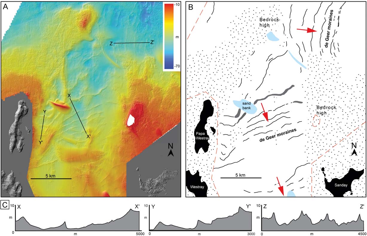
Other equivalent transverse seabed ridges, with similar dimensions and ridge spacings, occur in the waters around the Orkney Islands, particularly in North Sound between Westray and Sanday in present-day water depths of 20–70 m (Fig. 16). Collectively, we assign a common glacigenic (morainic) origin to these suites of transverse ridges with similar 3-D morphology and dimensions. Although the slope asymmetry may vary (steeper distal vs proximal slope) as well as the absolute dimensions, the de Geer-type moraines mapped on the Orkney–Shetland platform are easily distinguished in multibeam bathymetry from more recently formed sandbanks, sand waves or linear bedrock structures (Fig. 16). Owing to the very thin and patchy distribution of Pleistocene deposits on this part of the inner shelf, the Quaternary sequence around northern Orkney is undivided. However, on the basis of the regional stratigraphic overview (Stoker et al. Reference Stoker, Hitchen and Graham1993) any glacigenic sediments in this region are expected to fall within the Stormy Bank Formation (Stoker et al. Reference Stoker, Balson, Long and Tappin2011a, Reference Stoker, McMillan and Watersb). The steep-sided, fresh-looking form and good state of preservation of the Westray and North Sound moraines is entirely consistent with a Late Weichselian age; although no absolute age constraints currently exist (Figs 15, 16).
Around 30–50 km to the E of the Pentland Firth, in relatively shallow water (60–80 m water depth) to the SE of Orkney, are a number of seabed ridges and banks of differing scale and morphology clearly imaged in both single-beam and multibeam data (Figs 5, 6, 17). The three largest (and oldest) features are a collection of NE–SW-trending low, broad, discontinous ridges and mounds. The main ridge belts are 1–4 km wide and elevated only 5–10 m above the surrounding seabed, with gentle slopes and wide subtle, sometimes multiple, crest lines (Fig. 6). These features continue to the NE, outside the area covered by this study. Quaternary deposits in the area to the E of Orkney and the outer Moray Firth are not well understood, owing to the thin and patchy nature of Pleistocene deposits; those that are defined in BGS maps and reports are left undifferentiated (BGS 2013). Furthermore, no formal correlation has yet been made between glacial sediment sequences and landforms to the E of Orkney with those to the W of Orkney (e.g. Otter Bank Formation, Stormy Bank Formation, etc) (Stoker et al. Reference Stoker, Hitchen and Graham1993; Andrews et al. Reference Andrews, Long, Richards, Thomson, Brown, Chesher and McCormac1990). Superimposed, in places, on top of these broad ridges is a second set of more delicate NE–SW-trending transverse seabed ridges. These form suites of narrow closely spaced curvilinear ridges with well-defined, sometimes bifurcating, crest lines. In one suite, approximately 40 km E of Duncansby Head, 15 well-developed but discontinuous ridges are seen in a horizontal distance of ∼10 km at the extreme eastern edge of the study area (Fig. 17). The longest ridges can be traced laterally for ∼20 km, although most are shorter and continuous over only 5–10 km or less. Most ridges occur within a well-defined elevation threshold 65–75 m below present-day sea level; several ridges terminate abruptly where the seabed deepens (>75 m water depth). Ridges are typically 100–200 m wide and 1–5 m high; ridge spacings are in the range of ∼300–1000 m. In cross-profile, ridge asymmetry is marked, with most ridges possessing a steeper W- or NW-facing slope, although symmetrical and reversed asymmetry is noted in one or two cases (Fig. 17). No high-resolution seismic lines were available for this area; hence the internal sediment architecture could not be examined. However, the co-spatial presence of (presumably Holocene) marine bedforms in the multibeam data, with markedly different morphologies and orientations to both generations of seabed ridges, suggests that the ridges are not related to present-day marine bed-forming processes (Fig. 17). This fact, and the strong morphological similarity of the smaller transverse ridges to subaqueous moraines elsewhere, strongly suggests that they are Pleistocene glacigenic landforms, probably de Geer moraines akin to those seen elsewhere around Orkney (cf. Figs 15, 16). The collective evidence suggests that they were deposited by a large ice mass terminating in shallow water and retreating in a northwesterly direction back towards Orkney. The larger more subdued ridges are probably older (?terrestrial) end moraine complexes deposited during an earlier stage of firmly grounded ice sheet retreat and subsequently overprinted by de Geer moraines with a similar orientation, recording retreat of a lightly grounded (partly floating) tidewater ice-sheet margin.
Seabed moraines SE of Orkney: (A) hill-shaded multibeam bathymetry data showing suite of transverse ridges ∼40 km E of Duncansby Head, Outer Moray Firth; (B) summary map of transverse seabed ridges interpreted as subaqueous recessional (de Geer) moraines (black lines). Red arrow indicates direction of ice-sheet retreat inferred from moraine morphology. Note the absence of moraines in deeper water areas (>80 m); (C) bathymetric profile (in metres) perpendicular to crest line of moraines showing typical slope asymmetry; profile line shown in (A); (D) oblique view of seabed ∼25 km ENE of moraine suite in (A), looking N; shows moraines and marine bedforms at strongly different, almost perpendicular, orientations. Lines of bathymetric profiles are also shown. Lower panel: bathymetric profiles (in metres) perpendicular to transverse features, showing the markedly different cross-profile of de Geer moraines (steeper slopes; greater relief) vs. marine bedforms. Note different scales on x and y axes. Contains Maritime and Coastguard Agency MBES data.
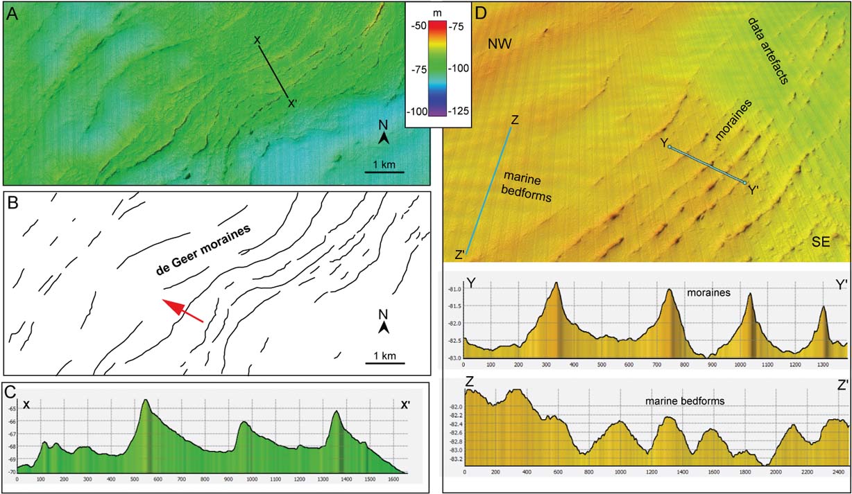
4. Discussion
4.1. Ice sheet reconstructions from submarine glacial landforms
Previous work has shown the general pattern of ice-sheet moraines around Northern Scotland, based solely on low-resolution echo sounder bathymetry from the continental shelf (Bradwell et al. Reference Bradwell, Stoker, Golledge, Wilson, Merritt, Long, Everest, Hestvik, Stevenson, Hubbard, Finlayson and Mathers2008a). The wider pattern of ice sheet retreat across the British Isles was subsequently proposed by synthesising all the available onshore and offshore geomorphological data (Clark et al. Reference Clark, Hughes, Greenwood, Jordan and Sejrup2012). We use the pattern of ice-marginal landforms, mapped here from single-beam and new multibeam echo sounder data (Fig. 6) and supported by seismostratigraphic interpretations and published Quaternary geological information, to reconstruct in more detail the ice-sheet configuration around northern Scotland at maximal extent and during deglaciation. Palaeo-ice margins are reconstructed based on the position and orientation of ice-marginal landforms (i.e., moraines and grounding-zone features), as has been done routinely in numerous palaeo-glaciological studies onshore and offshore (e.g., Bennett & Boulton Reference Bennett and Boulton1993; Benn et al. Reference Benn, Kirkbride, Owen, Brazier and Evans2003; Ó Cofaigh et al. Reference Ó Cofaigh, Dunlop and Benetti2012; Rydningen et al. Reference Rydningen, Vorren, Laberg and Kolstad2013). However, it is especially important that the stratigraphic relationships established between the different moraine-bearing formations are fully considered when attempting to reconfigure the palaeo-ice margins. Digitised crest lines, based on digital surface model data, or high points (where no crest could be discerned), of mapped moraines were used to mark the position of the former ice front. Adjacent, along-strike, crest lines were then joined using a continuous line where they form obvious chains, or coherent sequences; dashed lines were used where the interpretation is less certain. For example, dashed lines show a sense of connectivity between seabed moraines where extensive areas of bedrock are present at seabed or bathymetric data is lacking. Careful consideration of the bathymetry/topography was made at all times to improve the glaciological plausibility of reconstructed ice margins, especially when interpolating ice margins over long distances of >20 km. In certain areas, where glacial landform evidence is absent or very complex and difficult to interpret, no correlations with adjacent landforms were made. It should be remembered that the resulting map of reconstructed palaeo-ice margins is only firmly constrained where data coverage and landform evidence is good (see Figs 2, 5). Interpolated ice margins are clearly open to interpretation and we accept that other glaciologically plausible scenarios may exist. Furthermore, these reconstructions are likely to be refined and clarified in places, given the large amount of multibeam data becoming available from UK waters every year. Finally, no correlation with onshore moraines has been attempted in this work, owing to time constraints and the variable quality and vintage of Quaternary geological mapping in northern mainland Scotland and the Outer Hebrides (Clark et al. Reference Clark, Evans, Khatwa, Bradwell, Jordan, Marsh, Mitchell and Bateman2004; Evans et al. Reference Evans, Clark and Mitchell2005; BGS 2012). However, it is hoped that improved onshore–offshore correlations will form the focus of future research.
4.2. Ice-sheet retreat pattern and evolution
Our map of reconstructed ice margin positions around northern Scotland clearly shows the variations in ice sheet extent and geometry over time (Fig. 18). The overall pattern represents a large sector of the BIIS undergoing a widespread, but punctutated, size reduction – accompanied by significant changes in geometry – as it retreats, reorganises and ultimately disappears, in response to internal and external drivers. These general findings echo those put forward by Bradwell et al. (Reference Bradwell, Stoker, Golledge, Wilson, Merritt, Long, Everest, Hestvik, Stevenson, Hubbard, Finlayson and Mathers2008a), based solely on single-beam bathymetry data; but our detailed findings in the NW sector differ from the general three-stage model we proposed in 2008, as well as from some of the ‘timeslice’ reconstructions of Clark et al. (Reference Clark, Hughes, Greenwood, Jordan and Sejrup2012).
Reconstructed ice-sheet margins around northern Scotland, based on new geomorphological seabed mapping. Coloured lines show key ice-margin positions (Stages 1–10) during retreat. Solid lines are based on landform evidence (moraines); dashed lines are inferred or extrapolated. Key published terrestrial cosmogenic nuclide (TCN) exposure ages (from Phillips et al. Reference Phillips, Hall, Ballantyne, Binnie, Kubik and Freeman2008; Bradwell et al. Reference Bradwell, Stoker, Golledge, Wilson, Merritt, Long, Everest, Hestvik, Stevenson, Hubbard, Finlayson and Mathers2008a; Everest et al. Reference Everest, Bradwell, Stoker and Dewey2013) are also shown. TCN ages are means of several samples. Note the strongly asymmetric pattern of deglaciation relative to the shelf break – exemplified in Stage 7 – with ice-sheet retreat back to the coastline in NW mainland Scotland, at the same time as ice-sheet oscillations on the mid shelf W of Orkney and on the outer shelf W of Shetland. This reconstructed pattern of British–Irish Ice Sheet retreat differs from current models (cf. Bradwell et al. Reference Bradwell, Stoker, Golledge, Wilson, Merritt, Long, Everest, Hestvik, Stevenson, Hubbard, Finlayson and Mathers2008a; Clark et al. Reference Clark, Hughes, Greenwood, Jordan and Sejrup2012), and points to a large ice mass centred over Orkney–Shetland at a relatively late stage during Weichselian deglaciation. This model forms a new framework which will be tested by future work.
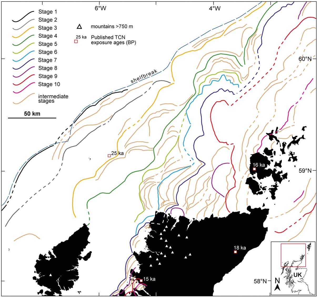
Examining the geographical distribution of ice-marginal landforms more closely, a detailed pattern of ice-sheet retreat emerges. Importantly, when combined with the distribution of Quaternary (Pleistocene) deposits on the NW UK continental shelf, compiled independently from seismostratigraphical evidence in the 1980s (Stoker et al. Reference Stoker, Hitchen and Graham1993), the pattern becomes more coherent and is firmly supported within a lithostratigraphic (relative-chronological) framework (Fig. 18). The overall pattern depicted in Figure 18 is subdivided into ten key stages outlined below:
• Stage 1. Large shelf-edge moraines adjacent to the Sula Sgeir Fan (MacDonald Formation moraines) indicate that grounded ice sheets extended across the Hebrides Shelf during the Mid to Late Pleistocene (<0.45 Ma), but probably did not reach this far during the Late Weichselian (MIS 2) (Stoker et al. Reference Stoker, Hitchen and Graham1993; Stoker Reference Stoker, Hitchen, Johnson and Gatliff2013). Morphologically similar shelf-edge moraines occur on the outermost parts of the shelf in the Central sector and West of Shetland (Murray and Otter Bank Formation moraines); however, the mapped stratigraphic relationships between all three major units indicate that they are probably not directly time-equivalent (Figs 3, 4). The combined morphological and seismostratigraphic evidence suggests that at Stage 1 an extensive ice sheet fed the substantial continental-slope Sula Sgeir Fan, via the Minch ice stream, depositing glacigenic debris flows and glaciomarine muds (within the Macauley Formation, Upper Macleod Formation and Morrison Formation) (e.g. Stoker et al. Reference Stoker, Hitchen and Graham1993; Stoker & Bradwell Reference Stoker and Bradwell2005; Bradwell et al. Reference Bradwell, Stoker and Larter2007). This ice-sheet front probably also extended as a marine-terminating margin at, or close, to the shelf edge from west of Lewis (∼58°N) to west of Shetland (>61°N) prior to MIS 2–3. Parts of the ice front may have extended into deeper water as floating ice shelves, especially where the indented bathymetry of the shelf break potentially allowed the ice sheet to be laterally supported (e.g. Wyville-Thomson Ridge). It is very likely that seabed moraine evidence for pre-Weichselian ice-sheet margins north of ∼60°N have been subsequently buried or removed by later glaciations (see below).
• Stage 2. Large moraines on the outer shelf in the Hebrides Shelf and Central sectors, 10–30 km inboard from the shelf break, record significant still-stands or oscillations of a pre-Late Weichselian ice-sheet margin. The innermost MacDonald Formation moraine on the Hebrides Shelf extends to the NW for ∼100 km, where it is truncated or overprinted by Otter Bank Formation moraines (of Late Weichselian age) on the outer West Shetland shelf (Stage 3). To the NW of Lewis, the Stage 2 limit is uncertain. At this time, the ice sheet probably still formed a single coherent shelf-break-parallel ice-sheet margin, near to its maximal position (=Stage 1), at a time of greatly lowered eustatic sea levels. As with Stage 1, clear landform evidence of this pre-Weichselian ice sheet retreat is lacking N of ∼60°N.
• Stage 3. Moraines on the mid shelf in the Hebrides and Central sectors (North Lewis Ridge and N Rona Ridges) are correlated with moraines on the outer part of the West Shetland shelf based on morphological and sesimostratigraphic grounds. We infer a broadly lobate ice sheet margin stretching from NW of the Butt of Lewis to the North Rona High. These moraines (or grounding-line features) probably relate to the Minch ice stream front as it stabilised on prominent mid-shelf bathymetric highs. From here, this ice sheet limit continues ∼70 km NW to join with the outermost Otter Bank Formation moraines close to the shelf break at ∼60°N. The ice-sheet configuration in Stage 3 is not a shelf-parallel one; the ice margin being situated close to the present-day coastline in NW Lewis – which may have hosted ice-free areas very early during deglaciation, consistent with sedimentological evidence of long-lived periglacial conditions (e.g. at Galson Beach; Gordon & Sutherland Reference Gordon and Sutherland1993) – but situated at or close to the shelf break in the West Shetland sector. Shelf-wide seismostratigraphic relationships suggest that this ice sheet configuration probably occurred during the Late Weichselian Stadial (MIS 2–3), coeval with North Rona deglaciation ca. 25 ka BP (Everest et al. Reference Everest, Bradwell, Stoker and Dewey2013), when eustatic sea levels were still close to their eustatic (LGM) minimum. The subsequent Stages (4–10) are all thought to be of MIS 2 age.
• Stage 4. Large mid-shelf moraine complexes stretching from N Lewis to the West Shetland Shelf are interpreted to mark a single (long-lived?) Late Weichselian (MIS 2) ice sheet 20–30 km margin inboard of Stage 3. We join the prominent North Minch Ridge moraine with the Solan Bank Ridge and the outermost, nested, Otter Bank Formation moraine NW of Orkney, which continues NW across the West Shetland Shelf for over 60 km. The ice sheet margin depicted by Stage 4 is developing a more asymmetric form relative to the continental shelf break, being ∼75 km from the shelf break in the Hebrides Shelf sector but <20 km from the shelf break on the West Shetland shelf in the extreme north. The ice sheet front was probably stably situated on land close to the present-day coastline in western Lewis at this time. Relative sea levels on the continental shelf NW of Britain at ∼20–25 ka BP are poorly constrained, but numerical glacio-isostatic models place them ca. 100 m below present levels on the mid to outer shelf (Lambeck Reference Lambeck1991, Reference Lambeck1993). The implication is that the ice sheet margin at this time was probably grounded below sea level to the N of Lewis, in the Minch and on the shelf NW of Orkney, but perhaps terminated close to sea level in shallows or on low-lying palaeo-islands in the central sector (around the Solan Bank high). It is likely that de-glaciated parts of the shelf W of Lewis and around North Rona would have also been dry land. We suggest that the interaction between topography, relative sea level and ice sheet grounding dynamics would have been particularly important in determining the rate and style of ice sheet retreat across the shelf at this time.
• Stage 5. Many small and medium-sized moraines occur on the seabed in the central sector inshore of the North Minch–Solan Bank Ridge. We draw a contiguous ice-sheet margin joining the outermost of these, to the W of Cape Wrath, with a moraine system to the E of the Solan Bank High. Unfortunately, no firm connection can be made between this moraine and those further N, owing to discontinuous landform evidence, but a link with one of the large nested Otter Bank Formation moraines on the mid shelf is highly likely on geomorphological and seismostratigraphical grounds. Stage 5 has no mapped equivalent in the Minch or N of ∼60°N, where it has been subsequently truncated or removed by later glacial advances (see below; Stages 6, 7).
• Stage 6. The NW Sutherland moraines, to the N of the large Eddrachillis Ridge, are projected to make landfall 5–10 km S of Cape Wrath. We join this ice sheet limit, across the Cape Wrath headland, with the Nun Rock Moraine and its lateral equivalent to the N. We continue this ice sheet margin, around the bathymetric Sule Skerry High, to the N where it joins with one of the large nested Otter Bank/Stormy Bank Formation moraines on the mid shelf, NW of Orkney. It is not currently possible to firmly trace the Stage 6 ice-sheet limit beyond this point, owing to the presence of bedrock at seabed across a large area. Relative sea levels on the continental shelf at this time are not well constrained, but were still probably considerably lower (∼100 m) than the present day (Lambeck Reference Lambeck1991), exposing palaeo-islands in the Central sector and on the Hebrides Shelf.
• Stage 7. The northern Minch, an area of ∼2500 km2, is notably lacking in ice-marginal landforms. The next suite of moraines encountered inshore of the North Minch Ridge, in the Hebrides sector, is the major nearshore system defined by the substantial Eddrachillis Ridge and Rubha Coigeach/Greenstone Point/Loch Ewe Moraine complexes. We interpolate a multi-lobed ice sheet margin extending from SW of Loch Ewe (Wester Ross) to the vicinity of Sandwood Bay, in NW Sutherland, where it makes landfall and probably continues across the Cape Wrath headland. The Stage 7 time-equivalent moraine system in the central sector cannot be firmly determined, owing to paucity of onshore data in far NW Sutherland; however, correlation with one of the regional moraines between Cape Wrath and Faraidh Head (e.g. RM3, Fig. 12) is most glaciologically plausible. This palaeo-ice sheet margin continues, with three strong inflections, for 150 km to the N until it joins the lobate nested Otter Bank/Stormy Bank moraine complex NW of Orkney. No firm correlations can be made N of this point, as moraines are not currently mapped across a large submarine bedrock area on the western Orkney–Shetland Platform, but a continuation to morphologically-similar Stormy Bank Formation moraines on the West Shetland shelf is most likely. The NW sector of the BIIS has a strongly asymmetric configuration in Stage 7 – with the ice-sheet margin close to the present-day coastline in mainland NW Scotland, >120 km inshore from the shelf break; ∼50 km from the shelf break NW of Orkney; and only ∼20 km from the shelf break on the West Shetland Shelf.
• Stage 8. This stage is defined only by a large lobate moraine complex that truncates (or overprints) the sequence of several regional moraines (W of the Reay Moraine) running broadly perpendicular to the N coast of mainland Scotland. It probably represents a short-lived re-advance of the ice sheet margin into deeper water west of Orkney. Time-equivalent moraines further N have most likely been removed by subsequent ice sheet re-advances (see Stage 9), although a prominent moraine ridge in the extreme NE of the study area may relate to this stage. Stage 8 may also have a time-equivalent ice sheet margin in the Summer Isles region where numerous seabed moraines record a period of repeated still-stands/re-advances during overall ice-sheet retreat prior to ∼15 ka BP (Bradwell et al. Reference Bradwell, Fabel, Stoker, Mathers, Mchargue and Howe2008b; Stoker et al. Reference Stoker, Bradwell, Howe, Wilkinson and Mcintyre2009); however, correlation cannot be confirmed with those moraines to the N of mainland Scotland, owing to a lack of chronological constraints. The late-stage re-advance (Faraidh Head) moraines offshore Loch Eriboll are also tentatively placed in Stage 8, on the basis of glaciological plausibility (i.e. post-dates Stage 7), though currently no published chronological data exist to confirm this.
• Stage 9. Represented by the distinctive double-crested lobate Reay Moraine, offshore NW Caithness, this palaeo-ice sheet margin records a relatively large, but possibly short-lived, re-advance of the ice sheet up to, and in places over, another prominent regional moraine. Extending N for ∼40 km, the Reay Moraine can be intermittently traced across a wide area of bedrock seabed W of Orkney. We correlate the Reay Moraine with the morphologically-similar, double-crested Westray Loop Moraine – the innermost Stormy Bank Formation moraine, NW of Orkney – the distinctive lobate morphology and seismic architecture of which is also highly suggestive of a dynamic short-lived re-advance. Any substantial ice-sheet re-advance (>10 km) is likely to have removed landform evidence of earlier retreat stages in this region, hence the general absence of Stage 8 and intermediate moraines on the West Shetland Shelf and Orkney–Shetland Platform. Time-equivalent Stage 9 moraines to the E of 3°30'W are hard to identify with certainty, owing to a large area of bedrock-dominated seabed, but a link to the innermost prominent Stormy Bank Formation moraine on the West Shetland shelf is highly likely. To the SE of Orkney, we infer an ice sheet margin, broadly concave to the NW, based on the largest seabed moraines identified; this pattern is suggestive of an ice mass centred on the higher ground of the Orkney–Shetland platform. The pattern and morphology of the surrounding de Geer moraine fields strongly support this Orkney–Shetland-centred ice sheet/ice cap geometry. Like Stage 8, Stage 9 may have a time-equivalent ice sheet margin in the Summer Isles region, where numerous seabed moraines, and their onshore counterparts, record a period of repeated still-stand/re-advance during the final stages of ice sheet decay in NW Scotland (Bradwell et al. Reference Bradwell, Fabel, Stoker, Mathers, Mchargue and Howe2008b; Stoker et al. Reference Stoker, Bradwell, Howe, Wilkinson and Mcintyre2009). Taken collectively, the carefully reconstructed Stage 9 ice margins represent a considerable reconfiguration during overall ice-sheet decay, when the northern sector of the British–Irish Ice Sheet had reorganised into large separate ice masses – one centred over Orkney and Shetland, and one centred over the western Scottish Highlands – with an ice-free corridor between. This is the first time this ice sheet configuration has been proposed for the BIIS.
• Stage 10. Ice-marginal landforms on the Orkney–Shetland Platform are small, mostly de Geer-type moraines, suggesting relatively rapid retreat of tidewater ice margins. Stage 10 marks one of numerous (?brief) still-stands during overall decay of the ice sheet/cap in its final stages, as a separate ice mass centred over Orkney and Shetland. The choice of de Geer moraine to represent this stage is not important; we simply represent a notional stage during final deglaciation – probably around 15–17 ka BP, as determined by TCN exposure ages on Orkney (Phillips et al. Reference Phillips, Hall, Ballantyne, Binnie, Kubik and Freeman2008). The chosen ice-sheet margin can be traced from the northern mainland of Orkney across the Westray Firth and linked with the prominent de Geer moraines offshore Papa Westray that continue for ∼20 km to the NE, and possibly join with those in the Orkney–Shetland Channel. It is currently not possible to firmly identify equivalent Stage 10 moraines to the east of Orkney, owing to a lack of moraine pattern information close to shore. However, we propose that morphologically-similar de Geer moraines in comparable water depths to those NE of Papa Westray (<65 m) support this overall pattern of ice-front retreat back towards Orkney. Broadly time-equivalent ice-sheet moraines in the fjords of the Summer Isles region (∼15 ka BP; Bradwell et al. Reference Bradwell, Fabel, Stoker, Mathers, Mchargue and Howe2008b; Stoker et al. Reference Stoker, Bradwell, Howe, Wilkinson and Mcintyre2009) record late-stage ice sheet/ice cap oscillations attributed to the final stage of marine-terminating glaciers in northern mainland Scotland.
We suggest that this ten-stage reconstruction of ice sheet retreat, with over 30 intermediate stages (Fig. 18), represents the most detailed and glaciologically plausible pattern of ice sheet retreat for the NW sector of the BIIS based on the currently available (as at December 2013) marine geophysical and geological data. This work refines those previous reconstructions presented for this region by Bradwell et al. (Reference Bradwell, Stoker, Golledge, Wilson, Merritt, Long, Everest, Hestvik, Stevenson, Hubbard, Finlayson and Mathers2008a) and Clark et al. (Reference Clark, Hughes, Greenwood, Jordan and Sejrup2012).
4.3. Chronology
Very few absolute dates currently exist for the formation of the seabed moraine systems around northern Scotland; addressing this forms one of the main objectives of the ongoing BRITICE-CHRONO research project (Clark et al. Reference Clark, Fabel, Ó Cofaigh, Chiverrell, Scourse, Hindmarsh and Bradwell2014). Notwithstanding this sparse chronology, most of the glacial landforms identified (excluding Stages 1–2) are believed to relate to the last ice sheet to have covered the British Isles (=Late Weischselian glaciation; ca. 32–15 ka BP) (in agreement with others: e.g., Sejrup et al. Reference Sejrup, Hjelstuen, Dahlgren, Haflidason, Kuijpers, Nygard, Praeg, Stoker and Vorren2005, Reference Sejrup, Nygard, Hall and Haflidason2009; Carr et al. Reference Carr, Holmes, van der Meer and Rose2006; Bradwell et al. Reference Bradwell, Stoker, Golledge, Wilson, Merritt, Long, Everest, Hestvik, Stevenson, Hubbard, Finlayson and Mathers2008a; Chiverrell & Thomas Reference Chiverrell and Thomas2010; Clark et al. Reference Clark, Hughes, Greenwood, Jordan and Sejrup2012). We consider this premise to be supported by four key independent lines of evidence:
1) Geomorphological preservation: we consider it unlikely that ice-marginal features (particularly small moraines) would have survived overriding by subsequent glaciation(s). This implies that at least the younger, morphologically more delicate, moraines seen in Stages 5–10, on the inner and mid shelf (Figs 6, 9–17), are almost certainly Late Weichselian in age (<30 ka BP).
2) Seismostratigraphy: interpretation of shelf-wide seismic data in the 1970s to 1990s shows a distribution and architecture of Pleistocene glacigenic deposits entirely consistent with advance and retreat of an ice sheet to/from the continental shelf edge, at least on the West Shetland Shelf, during the Late Weichselian (Figs 3, 19) (Stoker et al. Reference Stoker, Hitchen and Graham1993, Reference Stoker, Leslie, Scott, Briden, Hine, Harland, Wilkinson, Evans and Ardus1994; Fyfe et al. Reference Fyfe, Long and Evans1993; Stoker Reference Stoker, Hitchen, Johnson and Gatliff2013).
3) Ice-rafted detritus (IRD) evidence: marine cores recovered from deep water SW of the Barra–Donegal trough-mouth fan record a strong increase in ice-rafted detritus at ∼29 ka BP, peaking at 26.5 ka BP – interpreted to reflect the maximum calving flux from a proximal ice sheet source (Peck et al. Reference Peck, Hall, Zahn, Grousset and Hemming2007; Scourse et al. Reference Scourse, Haapaniemi, Colmenero-Hidalgo, Peck, Hall, Austin, Knutz and Zahn2009). This IRD peak is widely associated with maximum stage shelf-edge BIIS glaciation on the Malin Shelf and southern Hebrides Shelf in the Late Weichselian (MIS 2–3).
4) TCN age constraints: a suite of terrestrial cosmogenic nuclide (TCN) analyses from North Rona on the mid shelf date the deposition of glacial boulders and, hence, indicate ice sheet overriding ca. 25 ka BP (Everest et al. Reference Everest, Bradwell, Stoker and Dewey2013). These data constrain the period of maximum Late Weichselian glaciation (post-Stages 1 & 2) to between ∼25 ka BP and the sharp IRD increase at ∼29 ka BP. It follows, based on this chronology, that Stage 3 moraines just inshore of North Rona (and the subsequent Stages 4–10) must be younger than ∼25 ka BP. TCN exposure ages of ∼15–17 ka BP from low-level sites on mainland Orkney (Phillips et al. Reference Phillips, Hall, Ballantyne, Binnie, Kubik and Freeman2008) constrain thinning and final decay (Stage 10) of a large ice mass, which we infer to have been centred over Orkney and Shetland. Furthermore, TCN exposure ages from the moraines in the Summer Isles region constrain final onshore retreat of a time-equivalent large ice mass centred over W Scotland at ∼15 ka BP (Bradwell et al. Reference Bradwell, Fabel, Stoker, Mathers, Mchargue and Howe2008b; Ballantyne et al. Reference Ballantyne, Schnabel and Xu2009).
Distribution of seabed moraines mapped from echo sounder bathymetry data (this study) overlaid on the distribution of Quaternary Formations on the NW UK Continental Shelf, mapped from seismostratigraphy and borehole data (modified from Stoker et al. Reference Stoker, Hitchen and Graham1993). Ice-marginal landforms are from Figure 5; grey polygons (large); thin black lines (small) moraines. Note the clear agreement between the two independently derived maps: the generally eastward-younging Pleistocene sequence, north of 59°N, matches well with the pattern of seabed moraines, indicating predominantly eastward or southeastward ice sheet retreat.
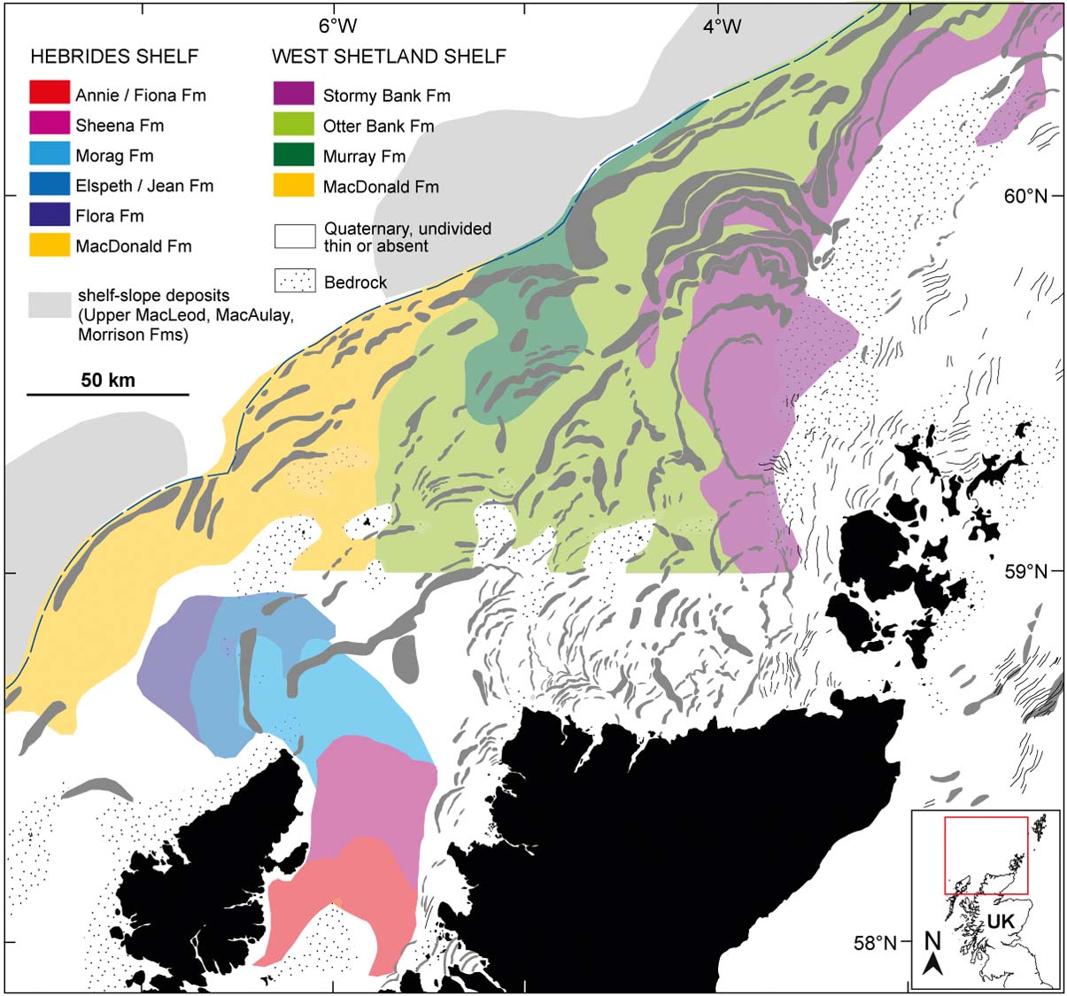
Owing to this relatively weak chronology, and the fact that it is currently the subject of a major onshore and offshore research effort (Clark et al. Reference Clark, Fabel, Ó Cofaigh, Chiverrell, Scourse, Hindmarsh and Bradwell2014), we deliberately do not attempt to put our reconstruction into a firm chronological context (i.e., by generating dated ‘timeslices’ or ‘isochrones’). However, we have used TCN exposure ages, where they exist, in key onshore localities to place reconstructed palaeo-ice sheet limits within a chronological framework and provide additional independent support for our empirically constrained ice-sheet retreat sequence (Fig. 18).
5. Summary, comparisons with previous work and some wider implications
The form and distribution of moraines on the seabed, seen in single-beam data and seismic sub-bottom profiles and in more detail in multibeam data, have allowed a new detailed pattern of ice-sheet retreat to be reconstructed for the continental shelf around northern Scotland. This pattern is one of a shrinking ice sheet undergoing extensive, non-uniform, sector retreat and major configuration change during decay. Our new reconstruction highlights that retreat was not simply concentric but strongly asymmetric – focused in marine-influenced sectors, most notably the Minch, where moraines are absent over ∼2500 km2 of seabed. This evidence, combined with the presence of well-preserved seabed glacial lineations – ice-stream bedforms – in the central part of the Minch (Stoker & Bradwell Reference Stoker and Bradwell2005; Bradwell et al. Reference Bradwell, Stoker and Larter2007), suggests deglaciation may have occurred rapidly in this vulnerable bathymetric setting (e.g., Alley et al. Reference Alley, Clark, Huybrechts and Joughin2005; Dowdeswell et al. Reference Dowdeswell, Ottesen, Evans, Ó Cofaigh and Anderson2008; Pritchard et al. Reference Pritchard, Arthern, Vaughan and Edwards2009).
The optimal reconstruction, based on newly available and collated existing data, depicts a single coherent ice-sheet margin initially retreating across the continental shelf broadly from NW to SE in a shelf-edge-parallel fashion (Stages 1–2; Fig. 18). However, it is very likely that these landforms relate to a pre-Weichselian, Mid to Late Pleistocene glaciation of Britain (Stoker et al. Reference Stoker, Hitchen and Graham1993; Stoker Reference Stoker, Hitchen, Johnson and Gatliff2013). Evidence of Late Weichselian glaciation (MIS 2) is seen in Stages 3 and 4 and the subsequent deglacial stages (5–10). Raised marine sediments at Galson in NW Lewis, first recorded by Baden-Powell (Reference Baden-Powell1938), have been interpreted to represent ice-free conditions throughout the last glaciation (Sutherland & Walker Reference Sutherland and Walker1984); although this has been strongly challenged (Hall et al. Reference Hall, Peacock and Connell2003). Our new reconstruction places the ice sheet margin onshore in NW Lewis at a very early stage during MIS 2 deglaciation (probably ∼25 ka BP) – entirely consistent with Quaternary geological evidence for periglacial conditions throughout much of the last glacial cycle (Gordon & Sutherland Reference Gordon and Sutherland1993). Following Stage 4, regional retreat patterns become focused in sectors – probably driven by changes in bed topography, bathymetry and ice dynamics – with the main part of the Minch (58–58.5° N) deglaciating in an uninterrupted fashion, perhaps very rapidly, without the formation of moraines. From this point onwards, the ice sheet configuration is substantially and irreversibly changed. With the ice sheet margin close to the coastline in NW Scotland and large ice sheet lobes terminating on the mid-shelf west of Orkney and Shetland (Stages 5–7; Fig. 18), the geometry is strongly asymmetric with respect to the present-day coastline and continental shelf break. Continued ice sheet retreat, and geometry change (accompanied by thinning), probably resulted in dynamic shifts in ice centres – with a large ice centre focused over the Orkney–Shetland Platform and another large ice centre dominating the West Scottish Highlands. We suggest that physical separation of these ice masses probably occurred between Stages 7 and 9, with far NW Scotland (Cape Wrath to Foinaven) being revealed relatively early as the ice sheets parted along the spine of high mountains (<750 m asl; Fig. 18). An ice-free corridor(s) connecting NE (Moray Firth) and NW mainland Scotland could have occurred at this time. Continued recession of the northern ice centre was seemingly punctuated by (?short-lived) re-advances of the ice margin (Stage 9), before final decay of the ice mass occurred in the vicinity of the Orkney Islands (Stage 10; Fig. 18) (ca. 15–17 ka BP; Phillips et al. Reference Phillips, Hall, Ballantyne, Binnie, Kubik and Freeman2008). A separate, but relatively large local ice centre probably also existed on Shetland at this time (cf. Golledge et al. Reference Golledge, Finlayson, Bradwell and Everest2008; Hall Reference Hall2013). The currently-available evidence suggests that the southern ice centre, focused over the western Scottish Highlands, had retreated onshore by ∼15 ka BP (Stage 10; Fig. 18), at least in the Assynt, Summer Isles and Wester Ross regions (Bradwell et al. Reference Bradwell, Fabel, Stoker, Mathers, Mchargue and Howe2008b; Ballantyne et al. Reference Ballantyne, Schnabel and Xu2009); whereafter its behaviour and final decay pattern is still the subject of debate (cf. Stoker et al. Reference Stoker, Bradwell, Howe, Wilkinson and Mcintyre2009; Finlayson et al. Reference Finlayson, Golledge, Bradwell and Fabel2011; Ballantyne & Stone Reference Ballantyne and Stone2010).
In their comprehensive ice-sheet-wide summary, combining all relevant chronological and geomorphological evidence, Clark et al. (Reference Clark, Hughes, Greenwood, Jordan and Sejrup2012, figs 17, 18) showed schematic, albeit generalised, reconstructions of ice-sheet retreat at key intervals during deglaciation. Focusing on northern Scotland, they proposed time-equivalent, contiguous, ice-sheet limits (isochrones), with some similarities to the three-stage reconstructions presented by Bradwell et al. (Reference Bradwell, Stoker, Golledge, Wilson, Merritt, Long, Everest, Hestvik, Stevenson, Hubbard, Finlayson and Mathers2008a) and the more detailed multi-stage reconstructions presented here (Fig. 18). Most notable similarities are: the shelf-edge configuration at maximum stage (isochrone ‘27 ka’ in Clark et al. (Reference Clark, Hughes, Greenwood, Jordan and Sejrup2012); but note the Pre-Weichselian age for Stages 1–2 (this study)); the general W–E retreat of ice on the Hebrides and Shetland shelves, with proportionately more ice loss in the S relative to the N (isochrones ‘27–17 ka’); the large open embayment in the Minch (isochrones ‘19–17 ka’); and the presence of separate late-stage ice centres on Orkney (and Shetland) and mainland Scotland (by isochrone ‘16 ka’). Where the reconstructions (Clark et al. Reference Clark, Hughes, Greenwood, Jordan and Sejrup2012 and this study) significantly diverge, however, is in the configuration changes that occur following their ‘isochrone 17 ka’ (broadly equivalent to our Stages 4–5). We envisage that the ice sheet ‘unzipped’ along the spine of high ground in NW Sutherland relatively early during deglaciation, radically altering the ice sheet geometry of both subsequent ice centres (referred to hereafter as northern and southern ‘ice sheets’). Moraine patterns suggest that this was followed by continued eastward retreat of the northern ice sheet's Atlantic margin, almost perpendicular to the N coast of mainland Scotland, towards the Orkney–Shetland Platform (Stages 6–9). At the same time, the geological evidence suggests the southern ice sheet's margin remained relatively stable in the eastern Minch, close to the present-day coastline (Stages 6–9), but that N–S thinning and retreat forced the terrestrial ice sheet margins back towards the main massifs of the Western Scottish Highlands. We find no evidence for an ice sheet limit adjacent and parallel to the north coast of mainland Scotland (cf. Clark et al. Reference Clark, Hughes, Greenwood, Jordan and Sejrup2012; with this study, Fig. 18). These key differences in ice-sheet retreat geometry, asymmetry and style, between previously published work (Clark et al. Reference Clark, Hughes, Greenwood, Jordan and Sejrup2012) and our new study, may be vitally important when seeking to chronologically constrain and refine the pattern of British–Irish Ice Sheet retreat using geological samples from onshore and offshore (e.g. using TCN, OSL, C-14, etc.). Alongside others, we seek to test and develop these hypotheses – part of ongoing work into the rate and style of marine-influenced ice-sheet decay around the British Isles.
6. Acknowledgments
This research was funded by BGS-NERC (Energy & Marine Geology Directorate) and is a scientific contribution to the MAREMAP programme. Bob Gatliff, Alan Stevenson and John Howe are thanked for organising the conference (Seabed Mapping in the 21st Century) and for inviting TB to contribute to it. This work was largely undertaken prior to the start of the NERC-funded BRITICE-CHRONO project, but has benefitted subsequently from conversations with several consortium members (most notably Chris Clark). We thank the journal reviewers for their comments and Rhys Cooper for processing MBES data. Vicki Hammond is thanked for editing the final MS. Multibeam echo sounder data were provided by MCA (UKHO), who are gratefully acknowledged. MCA survey data are Crown Copyright. Single-beam bathymetry data are from the Olex database, accessed under license by BGS/NERC. Published with the permission of the Executive Director, BGS (NERC). BGS/NERC Reference: 1PR/186-32CM.



